Showing 19 items matching " normanby avenue"
-
 Melbourne Tram Museum
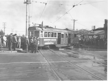
Photograph - W5 class 743 and truck collision in Thornbury - set of 9, Melbounre and Metropolitan Tramways Board, early 1970s
... ...Normanby Avenue...And two further photographs show the collision intersection days or weeks later from Normanby Avenue looking west. The collision appears to have occurred as south-bound 743 crossed Normanby Avenue and the truck cabin hit the driver's cabin and front left saloon wall. ...And two further photographs show the collision intersection days or weeks later from Normanby Avenue looking west. The collision appears to have occurred as south-bound 743 crossed Normanby Avenue and the truck cabin hit the driver's cabin and front left saloon wall. ...Five of the nine photographs show W5 class 743 (with destination 'City-Spencer St route 9A') with a demolished drivers cabin, severely burnt and derailed just south of the St Georges Road/Normanby Avenue intersection on a sunny dry day. They also show other vehicle, an overturned truck. Tramway workers, bystanders and fire brigade can be seen along with foam and smoke. Two further photographs show damaged 743 on an outside road at Preston Workshops. And two further photographs show the collision intersection days or weeks later from Normanby Avenue looking west. The collision appears to have occurred as south-bound 743 crossed Normanby Avenue and the truck cabin hit the driver's cabin and front left saloon wall. Perhaps the truck driver was travelling west on Normanby Road or turning west from St Georges Road and did not expect a south-bound tram on the west side of the centre reservation. Records show that the drop-centre section of 743 had its centre doors removed later in the 1970s and in 1985 was converted to an SW5.Yields information about the impact on W class trams of a major traffic collision and fire. Also the history or W5 class 743. Black and white prints with stamp and note on rear. "Melbourne & Metropolitan Tramways Board Ref No. P251.1898"w5 class, 743, demolished driver cabin, derailed, fire, st georges road, normanby avenue, preston workshops, drop-centre, sw5 class -
 Glen Eira Historical Society
Document - Historic Conservation Areas Project
... ... Normanby Avenue...Caulfield Library Dandenong Road Nepean Highway Hotham Street Iknerman Road Orrong Road North Road Poath Road ‘Plan of the City of Caulfield’ North Ward East Ward South Ward West Ward Kooyong Road Neerim Road Bambra Road Balaclava Road Shire of Caulfield Railways World War 1914-1918 Depression 1929-1939 Rippon Lea Labassa Parks Mansions Community Services ‘Caulfield North Draft Heritage Guidelines July 1999’ City of Glen Eira Caulfield North Heritage Area Glen Eira Heritage Management Plan Mayfield Grove Normanby Avenue Carnarvon Street Glenferrie Street Arthur Street Malakoff Street Normanby Road Heritage Advisory Service Construction Materials Victorian Style Mediterranean Style Spanish Mission Style Californian Bungalow Style Federation Style Architectural Style Architectural Features Heritage Conservation Design Building Construction Building Regulations Aboriginal Peoples Carnarvon Road Document Historic Conservation Areas Project ...Contains 4 items relating to historic conservation: 1/Five newsletters (one page each newsletter, dated 07/1975, 08/1975, 09/1975, 10/1975 and the final one 12/1975) describing how the project evolved, project funds, progress, study method, project 1 report, project 2 report and summary as no further funds available. Project was to include all of Melbourne but funding did not allow this. Note: newsletters stamped with Caulfield Historical Society. 2/Letter (one page on official city of Caulfield letterhead) from Andrew Rodda (manager planning) to Hazal Ford (dated 13/11/1989) describing ‘council resolved on 18/07/1989 to proceed with preliminary conservation survey’ and mentions that a copy is included. 3/Preliminary conservation survey for the City of Caulfield (nine pages) describing background, study area, budget, purpose, study outline, timeframe, report format, ownership, tasks and background information (mentions number and types of houses and properties as at 1986 and 1988) and a map of City of Caulfield. 4/Booklet (28 pages) titled ‘Heritage Area – Caulfield North Draft Heritage Guidelines July 1999 – City of Glen Eira’, containing Caulfield North Heritage Area, cultural heritage, Heritage Overlay Area, architectural description, common architectural forms and features, development guidelines, key design checklist. It includes a map of the Caulfield North Heritage Overlay Area, two illustrations about the development envelope and many black-and-white photographs of houses and architectural features.historic conservation areas project niven barbara, newsletters, town planning, historic buildings, heritage studies, housing, royal historical society of victoria (rhsv), read michael, plans, local government, historical societies, committee for urban action (cua), national trust, hopkins sherry ms., ford hazel, preliminary conservation survey, town planning, heritage studies, rodda andrew, city of caulfield, housing estates, victoria national estate grants program, australia icomos, burra charter, buildings structures and establishments, land surveys, suburbs, historic buildings, architectural significance, ‘caulfield’s heritage study’, soloman geulah dr., caulfield library, dandenong road, nepean highway, hotham street, iknerman road, orrong road, north road, poath road, ‘plan of the city of caulfield’, north ward, east ward, south ward, west ward, kooyong road, neerim road, bambra road, balaclava road, shire of caulfield, railways, world war 1914-1918, depression 1929-1939, rippon lea, labassa, parks, mansions, community services, ‘caulfield north draft heritage guidelines july 1999’, city of glen eira, caulfield north heritage area, glen eira heritage management plan, mayfield grove, normanby avenue, carnarvon street, glenferrie street, arthur street, malakoff street, normanby road, heritage advisory service, construction materials, victorian style, mediterranean style, spanish mission style, californian bungalow style, federation style, architectural style, architectural features, heritage conservation design, building construction, building regulations, aboriginal peoples, carnarvon road -
Glen Eira Historical Society
Letter - Pooley Family
... ... Normanby Avenue...Pooley Margaret Normanby Avenue Caulfield Dandenong Road Inkerman Road TOWONGA House names Graziers Pooley John Normanby Road Malvern Glen Eira Ellis Margaret Pooley Bessie Pooley John Ellis Pooley Percy Charles Pooley Edith Gwyn Pooley Ethel Margaret Ellwood Murray Glen Eira Historical Society Letter Pooley Family ...Printed history with research from Margaret Dunbar, in return for enquiry from Murray Ellwood about the Pooley and Ellis families of Normanby Road, Caulfield, with associated correspondence, dated 11/08/2010 and 22/07/2010.pooley margaret, normanby avenue, caulfield, dandenong road, inkerman road, towonga, house names, graziers, pooley john, normanby road, malvern, glen eira, ellis margaret, pooley bessie, pooley john ellis, pooley percy charles, pooley edith gwyn, pooley ethel margaret, ellwood murray, glen eira historical society -
 Kew Historical Society Inc
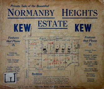
Plan - Subdivision Plan, Normanby Heights Estate, Kew, 1919
... ...normanby heights estate...pleasant avenue...The Normanby Heights Estate not unusually used hyperbole to attract purchasers to the auction of 17 lots facing Argyle Street (sic), Pleasant Avenue and Normanby Road. ...Barnes. subdivision plans - kew normanby heights estate pleasant avenue, normanby road, argyle street The Normanby Heights Estate not unusually used hyperbole to attract purchasers to the auction of 17 lots facing Argyle Street (sic), Pleasant Avenue and Normanby Road. ...Prue Sanderson, in her groundbreaking ‘City of Kew Urban Conservation Study : Volume 2 - Development History’ (1988), summarised the periods of urban development and subdivisions of land in Kew. The periods that she identified included 1845-1880, 1880-1893, 1893-1921, 1921-1933, 1933-1943, and Post-War Development. These periods were selected as they represented periods of rapid growth or decline in urban development. An obvious starting point for Sanderson’s groupings involved population growth and the associated economic cycles. These cycles also highlighted urban expansion onto land that was predominantly rural, although in other cases it represented the decline and breakup of large estates. A number of the plans in the Kew Historical Society’s collection can also be found in other collections, such as those of the State Library of Victoria and the Boroondara Library Service. A number are however unique to the collection.The Kew Historical Society collection includes almost 100 subdivision plans pertaining to suburbs of the City of Melbourne. Most of these are of Kew, Kew East or Studley Park, although a smaller number are plans of Camberwell, Deepdene, Balwyn and Hawthorn. It is believed that the majority of the plans were gifted to the Society by persons connected with the real estate firm - J. R. Mathers and McMillan, 136 Cotham Road, Kew. The Plans in the collection are rarely in pristine form, being working plans on which the agent would write notes and record lots sold and the prices of these. The subdivision plans are historically significant examples of the growth of urban Melbourne from the beginning of the 20th Century up until the 1980s. A number of the plans are double-sided and often include a photograph on the reverse. A number of the latter are by noted photographers such as J.E. Barnes.The Normanby Heights Estate not unusually used hyperbole to attract purchasers to the auction of 17 lots facing Argyle Street (sic), Pleasant Avenue and Normanby Road. Predictably factors appealed to included the proximity to schools etc, the availability of public utilities, friable soil, picturesque views and ‘advancing settlement’. If that were not enough, the sales pitch exhorted prospective purchasers to consider their backbone. ‘Thrift is unquestionably the Backbone of any Nation. No better form of Thrift can be encouraged in the young citizen than by investing his or her savings in a piece of land in a growing, healthy and beautiful locality. NORMANBY HEIGHTS ESTATE admirably fits the need.’ The experience of Australia at war undoubtedly contributed to the use of terms such as ‘Backbone of a Nation’ and the appeal to egalitarian principles in the choice of the term ‘young citizen’. The recognition that women had savings and might be the prospective purchaser also reflects a new sense of the rights and entitlements of women in the postwar period.subdivision plans - kew, normanby heights estate, pleasant avenue, normanby road, argyle street -
Glen Eira Historical Society
Book - CAULFIELD CENTENARY 1957
... Avenue... Normanby Road...Ward boundaries Dandenong Road Queens Avenue Normanby Road Station Street Bond Street Glen Eira Road Orrong Road Poath Road North Road Booran Road Nepean Highway Glen Huntly Road Glenhuntly Road Inkerman Road Hotham Street Nelson H.G. ...This file contains four items 1/Two copies of a twenty-four page booklet titled CITY OF CAULFIELD CENTENARY 1857-1957, created by the Caulfield City Council and printed by Peter Isaacson Pty Limited, Melbourne. The booklet details important aspects of Caulfield’s history including council procedures, the Caulfield Road District Proclamation, the first election and a summary of 100 years of local government with a description of the present Caulfield in 1957. The booklet also includes several pictures of various Caulfield landmarks and people including one of Caulfield City Councillors (11 men and 1 woman). Also one photocopied version of this booklet. 2/Eleven pages of typed notes for the City of Caulfield Centenary booklet. All notes are undated and incomplete. Two pages titled NOTES on THE HISTORY and PROGRESS OF THE CITY OF CAULFIELD, author unknown. Three and a half pages titled THE STRUCTURE OF LOCAL GOVERNMENT IN VICTORIA, author unknown. Five pages titled 100 YEARS OF LOCAL GOVERNMENT – EARLY CAULFIELD, by Mrs A. P. Bell. 3/A typed letter to Miss V. Webb-Langdon from the Town Clerk H.G. Nelson, acknowledging her contribution to historical details for the Caulfield Council’s Centenary booklet, dated 24/12/1957. 4/A handwritten letter and a handwritten note regarding the acquisition of notes for the Caulfield Centenary booklet. The letter is dated 03/08/2006 and the note is dated 09/02/2007.city of caulfield centenary, caulfield road district, sinclair a.j.g., city hall, war memorials, gamble h.a., machin l.r., bunny f.c.d., caulfield park, koornang reserve, parton e.m., sims h.e., thomson w.r., gunn e.e., yorston j.s., wallace g.e. mrs, green w.c., jenner e.r., ward boundaries, dandenong road, queens avenue, normanby road, station street, bond street, glen eira road, orrong road, poath road, north road, booran road, nepean highway, glen huntly road, glenhuntly road, inkerman road, hotham street, nelson h.g., fullard w.r., mackley g.j., ellis k.i, crosbie m.r., nutting b.i., body j.h., pritchard r.j., guildford l.t.g., lund l.m., street h.c., reynolds a.w., elections , political processes, local government, springthorpe reserve, greenmeadows gardens, business and finance, roads and streets, caulfield racecourse, east caulfield reserve, mackinnon reserve, hawthorn road, balaclava road, murrumbeena road, lempriere avenue, victoria street, koornang road, lord reserve, lyons street, murrumbeena reserve, kangaroo road, ormond park, beatty crescent, foch street, packer reserve, oakleigh road, leila road, prices park, bambra road, riley reserve, playgrounds, town hall, maternal and child health centres, truganini road, grange road, senior citizens centre, barkley sir henry, moore david, handasyde gilbert, caulfield school room, harris g.w., semple john, dempsey william, brooks w.a., wilson thomas, lyall william, murrum murrumbeen lifestyle, ‘greenmeadows’ house, lempriere family, aboriginal culture, ‘rippon lea’ house, caulfield john, ‘slaney’s’ home, alma road, paddy’s swamp, racecourse hotel, caulfield technical college, bevan mr., ‘grosmont’, hart john, railways, mansions, ‘rosecraddock’, langdon h. j., caulfield cup, ‘crotonhurst’, webb judge, ‘kilwinning’, service james, ricketson henry, ‘glen eira’, house names, garden vale, ross william murray, ‘ross’s folly’, outer circle railway, caulfield grammar school, davies j. henry, lagdon william, grimwade f.s., loyd charles du plan, hope george, ‘airdrie’, kooyong hill, market gardens, dairies, lady talbot milk supply, jenner family, o’niell college, presentation sisters, glenferrie road, grimwade frederick sheppard, grimwade alice, ‘harlston’, grimwade house, ‘saint aubin’s’, ‘st. aubin’s’, ‘caulfield hall’, caulfield john p.t., st georges road, caulfield military hospital, nursing homes, health establishments, dover street, sports and recreations, rosanna street, ‘cantala’, health services, parks and reserves, community services, town planning, local government finance, local officials and employees -
 Glen Eira Historical Society
Album - Album page, Normanby Road, Circa 1972
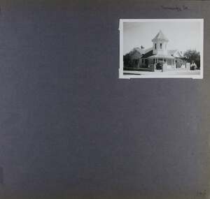
... Adopting forms and timber enrichment characteristic of the American Queen Anne style, it has this in common with the largely reconstructed timber villa at no. 11 Normanby Avenue and to a lesser extent, 746 Inkerman Road. ...Adopting forms and timber enrichment characteristic of the American Queen Anne style, it has this in common with the largely reconstructed timber villa at no. 11 Normanby Avenue and to a lesser extent, 746 Inkerman Road. ...This photograph is part of the Caulfield Historical Album 1972. This album was created in approximately 1972 as part of a project by the Caulfield Historical Society to assist in identifying buildings worthy of preservation. The album is related to a Survey the Caulfield Historical Society developed in collaboration with the National Trust of Australia (Victoria) and Caulfield City Council to identify historic buildings within the City of Caulfield that warranted the protection of a National Trust Classification. Principal photographer thought to be Trevor Hart, member of Caulfield Historical Society. Most photographs were taken between 1966-1972 with a small number of photographs being older and from unknown sources. All photographs are black and white except where stated, with 386 photographs over 198 pages. From: Glen Eira Heritage Management Plan (1996) - Vol 2 by Andrew Ward and Associates The widening of Dandenong Road during the late 1980's has resulted in the destruction of the houses in the path of the roadworks and the construction of a high fence serving as a visual barrier between that thoroughfare and the remaining houses. Where comparatively large villas once stood on spacious allotments, only "Wisteria" survives at No. 135 Normanby Road. Adopting forms and timber enrichment characteristic of the American Queen Anne style, it has this in common with the largely reconstructed timber villa at no. 11 Normanby Avenue and to a lesser extent, 746 Inkerman Road. Normanby Road retains its comparatively opulent Edwardian character in a mature landscaped setting with spacious gardens and mature planes parallel with the railway reserve which, on account of the low lying ground in its vicinity has a high embankment commencing on the alignment of Malvern Grove and continuing to Caulfield Station. The earliest villas are Edwardian. Page 148 of Photograph Album with one landscape photograph of a house on Normanby Road (not Street).Handwritten: Normanby St [top right] / 148 [bottom right]trevor hart, verandah, porch, bull nosed verandah, tower house, tower, stone fence, normanby road, wisteria, american queen anne style, queen anne style, 1890's, mayfield grove, normanby street, timber houses, caulfield north, house names, edwardian, edwardian style, gardens -
 Kew Historical Society Inc
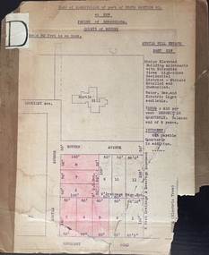
Plan - Subdivision Plan, J R Mathers & McMillan, Myrtle Hill Estate, East Kew, circa 1949, c.1949
... The subdivision plan of the ‘Myrtle Hill Estate’ indicates that in one such subdivision, 11 allotments were created fronting Bowyer Avenue, Myrtle Avenue, and Normanby Road. The outline and building profile of Myrtle Hill is shown on the west side of Bowyer Avenue....The subdivision plan of the ‘Myrtle Hill Estate’ indicates that in one such subdivision, 11 allotments were created fronting Bowyer Avenue, Myrtle Avenue, and Normanby Road. The outline and building profile of Myrtle Hill is shown on the west side of Bowyer Avenue. ...The Kew Historical Society's map collection includes a substantial number of real estate subdivision plans, mainly of Kew but also of surrounding suburbs in Melbourne. Most of the subdivision plans date from the 1920s and 1930s when the districts old homes and local farmland were being split up to accommodate residential growth in the postwar period. These early plans were assembled by a local firm, Jas R Mather & McMillan, which had an office in Cotham Road. Many of the plans, and sometimes photos, were annotated by the agents.Subdivision plans are historically important documents used as evidence for the growth of suburbs in Australia. They frequently provide information about when the land was sold as well as evidence relating to surveyors and real estate and financial agents. The numerous subdivision plans in the Kew Historical Society's collection represent working documents, ranging from the initial sketches made in planning a subdivision to printed plans on which auctioneers or agents listed the prices for which individual lots were sold. In a number of cases, the reverse of a subdivision plan in the collection includes a photograph of a house that was also for sale by the agent. These photographs provide significant heritage information relating house design and decoration, fencing and household gardens.The photograph may also be aesthetically significant depending on the importance of the photographic atelier.Myrtle Hill, at 14 Vista Avenue, Kew, is of local historical and architectural significance as a good example of a large and imposing single-storey Italianate house of the early 1870s surviving in Kew. Originally sited on a large allotment overlooking Normanby Road, the setting of the house has been dramatically altered through extensive subdivision and development. The subdivision plan of the ‘Myrtle Hill Estate’ indicates that in one such subdivision, 11 allotments were created fronting Bowyer Avenue, Myrtle Avenue, and Normanby Road. The outline and building profile of Myrtle Hill is shown on the west side of Bowyer Avenue.The full (typed) title of this subdivision plan is :"Plan of SUBDIVISION of part of CROWN PORTION 83. / at KEW / PARISH OF BOROONDARA. / COUNTY OF BOURKE". / "MYRTLE HILL ESTATE / EAST KEW" In addition to the Title and subtitle, the plan also lists the advantages of the subdivision. -
 Kew Historical Society Inc
Plan - Subdivision Plan, Jas R Mathers Son & McMillan, East Kew Tramway Estate, 1915
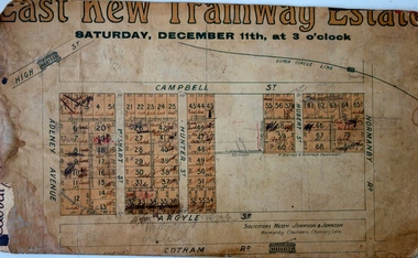
... The East Kew Tramway Estate was a subdivision of two separate parcels of land between Adeney Avenue and Normanby Road. The larger section included 54 lots facing Adeney Avenue, Argyle Road, and Campbell, Hunter and Wishart Streets. ...Barnes. east kew tramway estate subdivision plans - east kew The East Kew Tramway Estate was a subdivision of two separate parcels of land between Adeney Avenue and Normanby Road. The larger section included 54 lots facing Adeney Avenue, Argyle Road, and Campbell, Hunter and Wishart Streets. ...Pru Sanderson, in her groundbreaking ‘City of Kew Urban Conservation Study : Volume 2 - Development History’ (1988), summarised the periods of urban development and subdivisions of land in Kew. The periods that she identified included 1845-1880, 1880-1893, 1893-1921, 1921-1933, 1933-1943, and Post-War Development. These periods were selected as they represented periods of rapid growth or decline in urban development. An obvious starting point for Sanderson’s groupings involved population growth and the associated economic cycles. These cycles also highlighted urban expansion onto land that was predominantly rural, although in other cases it represented the decline and breakup of large estates. A number of the plans in the Kew Historical Society’s collection can also be found in other collections, such as those of the State Library of Victoria and the Boroondara Library Service. A number are however unique to the collection.The Kew Historical Society collection includes almost 100 subdivision plans pertaining to suburbs of the City of Melbourne. Most of these are of Kew, Kew East or Studley Park, although a smaller number are plans of Camberwell, Deepdene, Balwyn and Hawthorn. It is believed that the majority of the plans were gifted to the Society by persons connected with the real estate firm - J. R. Mathers and McMillan, 136 Cotham Road, Kew. The Plans in the collection are rarely in pristine form, being working plans on which the agent would write notes and record lots sold and the prices of these. The subdivision plans are historically significant examples of the growth of urban Melbourne from the beginning of the 20th Century up until the 1980s. A number of the plans are double-sided and often include a photograph on the reverse. A number of the latter are by noted photographers such as J.E. Barnes.The East Kew Tramway Estate was a subdivision of two separate parcels of land between Adeney Avenue and Normanby Road. The larger section included 54 lots facing Adeney Avenue, Argyle Road, and Campbell, Hunter and Wishart Streets. [Hunter and Wishart Streets were created as part of the subdivision.] A further 17 allotments faced Normanby Road, Hubert and Campbell Streets. [The name of Hubert Street was later to be changed to Cecil Street.] The promotion of the sale referred to the advantages of living between two tram routes, in High Street and Cotham Road. On the plan, quaintly drawn trams mark these routes. Also on the plan is the route of part of the Outer Circle [Railway] Line.east kew tramway estate, subdivision plans - east kew -
 Kew Historical Society Inc
Plan - Subdivision Plan, J R Mathers & McMillan, Plan of Subdivision of Part of Crown Portion 83 at Kew : LP6669, 1923-1939
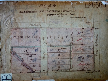
... In 1888, in the section of Park Hill Road between Belmont Avenue and Normanby Road there was only one street running between Park Hill Road and Cotham Road. ...Kew Historical Society Inc Kew Court House 188 High Street Kew melbourne In 1888, in the section of Park Hill Road between Belmont Avenue and Normanby Road there was only one street running between Park Hill Road and Cotham Road. ...In 1888, in the section of Park Hill Road between Belmont Avenue and Normanby Road there was only one street running between Park Hill Road and Cotham Road. This was Park Road, later to be named Adeney Avenue. Subsequent 20th century subdivisions created the ‘through roads’ of Cecil Street, Wimba Avenue, Florence Avenue, Marshall Avenue, Uvadale Road, and Barrington Avenue. This subdivision represents an attempt by auctioneers, rather than town planners to create an urban environment from larger residential allotments or in many cases farmland. Existing streets such as Parkhill and Normanby Roads provided a convenient starting point for the surveyors, but the Road named ‘Street Street’ indicates the role of the private surveyor in creating streets. Given that a number of allotments are listed as sold on the plan, the street is presumably Cecil Street. Even those lots that had been sold do not quite match the dimensions of the blocks in this parcel of land today, indicating that either further subdivisions or boundary alterations occurred.Subdivision plans are historically important documents used as evidence for the growth of suburbs in Australia. They frequently provide information about when the land was sold as well as evidence relating to surveyors and real estate and financial agents. The numerous subdivision plans in the Kew Historical Society's collection represent working documents, ranging from the initial sketches made in planning a subdivision to printed plans on which auctioneers or agents listed the prices for which individual lots were sold. In a number of cases, the reverse of a subdivision plan in the collection includes a photograph of a house that was also for sale by the agent. These photographs provide significant heritage information relating house design and decoration, fencing and household gardens.The photograph may also be aesthetically significant depending on the importance of the photographic atelier.Hand-drawn subdivision plan of 19 lots facing Parkhill Road, Normanby Road, and an unnamed street [now Cecil Street] in Kew.Estate Agent notes in ink indicate those lots which had sold.subdivision plans - kew, parkhill road - kew, cecil street - kew, normanby road - kew, cecil street -kew, parkhill road - kew, normanby road - kew, crown portion 83 - kew -
 Kew Historical Society Inc
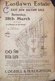
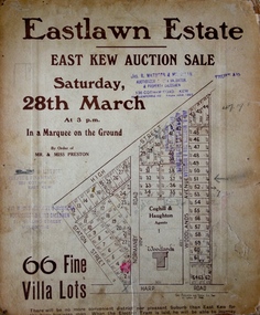
Plan - Subdivision Plan, Jas R Mathers Son & McMillan, Eastlawn Estate : East Kew Auction Sale, 1914
... station street, normanby road, high street, woodlands avenue, harp road...The allotments faced High, Station and Wright Streets, Harp and Normanby Roads, and Woodlands Avenue. Pru Sanderson in the Kew Conservation Study (Vol.2, 1988) wrote that the Eastlawn Estate ‘covered the western half of the failed Harp of Erin Estate’. ...The allotments faced High, Station and Wright Streets, Harp and Normanby Roads, and Woodlands Avenue. Pru Sanderson in the Kew Conservation Study (Vol.2, 1988) wrote that the Eastlawn Estate ‘covered the western half of the failed Harp of Erin Estate’. ...The Kew Historical Society's map collection includes a substantial number of real estate subdivision plans, mainly of Kew but also of surrounding suburbs in Melbourne. Most of the subdivision plans date from the 1920s and 1930s when the districts old homes and local farmland were being split up to accommodate residential growth in the postwar period. These early plans were assembled by a local firm, Jas R Mather & McMillan, which had an office in Cotham Road. Many of the plans, and sometimes photos, were annotated by the agents.Subdivision plans are historically important documents used as evidence for the growth of suburbs in Australia. They frequently provide information about when the land was sold as well as evidence relating to surveyors and real estate and financial agents. The numerous subdivision plans in the Kew Historical Society's collection represent working documents, ranging from the initial sketches made in planning a subdivision to printed plans on which auctioneers or agents listed the prices for which individual lots were sold. In a number of cases, the reverse of a subdivision plan in the collection includes a photograph of a house that was also for sale by the agent. These photographs provide significant heritage information relating house design and decoration, fencing and household gardens.The photograph may also be aesthetically significant depending on the importance of the photographic atelier.The ‘Eastlawn Estate’ was surveyed and ready for auction in March 1914, three months before the outbreak of World War I. Sixty-six allotments, created on the ‘order of Mr & Miss Preston’ surrounded the mansion of Woodlands in Harp Road. Woodlands formed part of the Estate, being advertised as lot 1. The allotments faced High, Station and Wright Streets, Harp and Normanby Roads, and Woodlands Avenue. Pru Sanderson in the Kew Conservation Study (Vol.2, 1988) wrote that the Eastlawn Estate ‘covered the western half of the failed Harp of Erin Estate’. Contemporary advertisements promoted the Eastlawn Estate as: ‘There will be no more convenient district nor pleasant Suburb than East Kew for the busy business man. When the Electric Tram is laid, he will be able to journey quickly and pleasantly direct from Collins Street to his home in the Eastlawn Estate in about 20 minutes’. The actual plans of subdivision were included in advertisements in The Argus and in the local newspapers."C" top left. Various annotations.subdivision plans - kew, station street, normanby road, high street, woodlands avenue, harp road, woodlands - kew -
 Kew Historical Society Inc
Plan - Subdivision Plan, Eastlawn Estate, 1914
... The allotments faced High, Station and Wright Streets, Harp and Normanby Roads, and Woodlands Avenue. Pru Sanderson in the Kew Conservation Study (Vol.2, 1988) wrote that the Eastlawn Estate ‘covered the western half of the failed Harp of Erin Estate’. ...The allotments faced High, Station and Wright Streets, Harp and Normanby Roads, and Woodlands Avenue. Pru Sanderson in the Kew Conservation Study (Vol.2, 1988) wrote that the Eastlawn Estate ‘covered the western half of the failed Harp of Erin Estate’. ...Subdivision plans are historically important documents used as evidence of the growth of suburbs in Australia. They frequently provide information about when the land was sold on which a built structure was subsequently constructed as well as evidence relating to surveyors and real estate and financial agents. The numerous subdivision plans in the Kew Historical Society's collection represent working documents, ranging from the initial sketches made in planning a subdivision to printed plans on which auctioneers or agents listed the prices for which individual lots were sold. In a number of cases, the reverse of a subdivision plan in the collection includes a photograph of a house that was also for sale by the agent. These photographs provide significant heritage information relating house design and decoration, fencing and household gardens.The ‘Eastlawn Estate’ was surveyed and ready for auction in March 1914, three months before the outbreak of World War I. Sixty-six allotments, created on the ‘order of Mr & Miss Preston’ surrounded the mansion of Woodlands in Harp Road. Woodlands formed part of the Estate, being advertised as lot 1. The allotments faced High, Station and Wright Streets, Harp and Normanby Roads, and Woodlands Avenue. Pru Sanderson in the Kew Conservation Study (Vol.2, 1988) wrote that the Eastlawn Estate ‘covered the western half of the failed Harp of Erin Estate’. Contemporary advertisements promoted the Eastlawn Estate as: ‘There will be no more convenient district nor pleasant Suburb than East Kew for the busy business man. When the Electric Tram is laid, he will be able to journey quickly and pleasantly direct from Collins Street to his home in the Eastlawn Estate in about 20 minutes’. The actual plans of subdivision were included in advertisements in The Argus and in the local newspapers.subdivision plans - east kew, eastlawn estate -
Glen Eira Historical Society
Document - Glen Eira Residents Association
... Normanby Road/Park Crescent... Kambrook Road... Balaclava Road... Hawthorn Road Tramway Estate... Caulfield South... Ulupna Road... Ormond... Murray Street... Prentice Street... Kambea Grove... Chestnut Street... McPherson Avenue...Whiteside Helen Mayor Save Our Suburbs (SOS) Walsh Mary Walsh Kevin French Christine Elsternwick Junction Planning Scheme Planning Scheme Amendment C87 Significant Character Areas (SCAs) Planisphere Final Report Oakdene Crescent Carnegie Blackwood Street Housing Diversity Areas Urandaline Grove Caulfield Normanby Road/Park Crescent Kambrook Road Balaclava Road Hawthorn Road Tramway Estate Caulfield South Ulupna Road Ormond Murray Street Prentice Street Kambea Grove Chestnut Street McPherson Avenue Queens Avenue Caulfield East Derby Crescent Clarinda Street St. ...Six items pertaining to Glen Eira Residents Asssociation Inc. 1/Two copies of the minutes of a Committee Meeting of Glen Eira Residents Association Inc., held on 04/12/2001. The minutes cover a range of routine meeting items, as well as the postponed release of the Princes Park Master Plans and the proposed construction of car parks at Caulfield Racecourse. 2/A copy of Glen Eira Residents’ Association Inc.’s 30/05/2003 newsletter, notifying members of matters presently before Glen Eira City Council for purposes of evaluation. Matters include an admonishment to the Council to sort out anomalies between the C25 Amendment (80/20 Plan) and the Melbourne 2030 Plan, the success at convincing the Ministerial panel to adopt GERA’s views regarding the C14 Council Plan for the Caulfield Racecourse, a request for information from the Council regarding the previous year’s rate increase, a request for information from the Council regarding spending on planning for improvements to Princes Park, a call for the Council to improve its consultative procedures, a recommendation that the purpose of Glen Eira News be expanded to the making of suggestions for city improvement, and a notification of the measures implemented to improve the visibility of Caulfield Racecourse’s usability by the public. Includes a black-and-white photograph of Orrong Road, Elsternwick, illustrating what Glen Eira’s roads would look like if lined with trees, which was excluded from Glen Eira News on account of a current prohibition on the making of suggestions for city improvements. 3/Four copies of a booklet entitled ‘A Short Guide to Planning Procedures’, composed 08/2006, which endeavours to explain, as concisely as possible, the methodology by which Glen Eira City Council approves real estate developments and issues planning permits. 4/A booklet containing the minutes of the 05/10/2009 Annual General Meeting of Glen Eira Residents’ Association Inc. Details both routine items and more specific matters of discussion, such as inappropriate charges on the part of the Glen Eira City Council and the proposed inception of a questionnaire to evaluate local residents’ opinion of the Council. 5/A booklet announcing the 07/10/2010 Annual General Meeting of Glen Eira Residents’ Association Inc. at St. John’s Uniting Church, Elsternwick. Front cover details agenda and contains four colour photographs pertaining to public transport (buses, trams, trains) within the city. Interior features president Don Dunstan reflecting on issues relevant to GERA occurring over the preceding twelve months, with an emphasis on the dubious behaviour of the City Council, as well as two colour photographs: one of Dunstan himself and one of traffic at Elsternwick Junction. The rear cover contains the Financial Statement presented to the Meeting. 6Two copies of a printout of an article from the website of Glen Eira Residents’ Association Inc., accessed 19/06/2012, explaining the affects wrought as a result of the implementation of Planning Scheme Amendment C87. Said amendment changes the Planning Scheme protecting neighbourhood character by replacing the previous Significant Character Area (SCA) designation with the new designations of Neighbourhood Character Overlay (NCO) and Design and Development Overlay (DDO). In developing the Amendment, Glen Eira City Council commissioned Planisphere to procure the Planisphere Final Report, in which recommendations regarding the expansion, creation and deletion of SCAs were offered. The article contains a summary of said recommendations.glen eira residents’ association inc., clubs and associations, glen eira, meetings, minutes, campbell jack, dunstan don, marwick geoff, pleydell max, teseriero dominic, robins kevin, princes park, south caulfield, glen eira city council, local government, councillors, brennan martin, victorian local government association (vlga), erlich mayor, project manikato, caulfield racecourse, caulfield racecourse flat, racecourses, parks, car parks, kennedy cr., kennedy norman mr., crown land, glen eira road, rippon lea, c25 plan (80/20), melbourne 2030 plan, c14 council plan, rates, orrong road, elsternwick, trees, station street, caulfield north, neerim road, glenhuntly, glenhuntly park, orrong ward, grossbard cr., martens cr., building permits, delegated planning committee (dpc), steward joy, brohier peter, campbell fliss, scutt alex, ray darren, hannah brian, st. john’s uniting church, mees paul dr., elsternwick club, sandham street, melbourne weekly bayside, glen eira debates, walsh investigation, whelen investigation, forge cheryl cr., whiteside helen mayor, save our suburbs (sos), walsh mary, walsh kevin, french christine, elsternwick junction, planning scheme, planning scheme amendment c87, significant character areas (scas), planisphere final report, oakdene crescent, carnegie, blackwood street, housing diversity areas, urandaline grove, caulfield, normanby road/park crescent, kambrook road, balaclava road, hawthorn road tramway estate, caulfield south, ulupna road, ormond, murray street, prentice street, kambea grove, chestnut street, mcpherson avenue, queens avenue, caulfield east, derby crescent, clarinda street, st. james parade/downshire road, exhibition street, mckinnon, field street, boyd park, murrumbeena, lindsay avenue, lydson street -
Glen Eira Historical Society
Document - Caulfield Sporting Club
... Normanby Road Caulfield... Moodie Road Caulfield... Kambrook Road Caulfield... Railway Avenue...Caulfield Sporting Club Caulfield Subscribers Memorandum Articles of association Jackson William Horace Webb Arthur John McCutcheon Arthur Robert Trusken James Way Henry Richard Normanby Road Caulfield Moodie Road Caulfield Kambrook Road Caulfield Railway Avenue Caulfield Stokes Henry Hyland Albert Williams John March Clifford Harris George Harris Monty V. ...This file contains one item. A handwritten report on the formation of the club on 07/03/1934, including company file number 18390, a list of subscribers to memorandum and articles of association, registered address, secretary members and directors year to 31/05/1939.caulfield sporting club, caulfield, subscribers, memorandum, articles of association, jackson william horace, webb arthur john, mccutcheon arthur robert, trusken james, way henry richard, normanby road caulfield, moodie road caulfield, kambrook road caulfield, railway avenue caulfield, stokes henry, hyland albert, williams john, march clifford, harris george, harris monty, v. r. c. trainer, bookmaker, agent, trainer, accountant, clubs, associations, societies, organisations, sports, recreations, competitions, entertainment, sports grounds, leisure, establishments, sports people, public record office, secretary, directors, victorian racing club -
 Kew Historical Society Inc
Plan - Subdivision Plan, J R Mathers & McMillan, Normanby Estate, c.1913
... The Normanby Estate, which was adjacent to Normanby Road, Kew East, included thirty-one lots for sale. Streets on the subdivision plan include Adeney Avenue, Park Hill Road, Normanby Road, Weir Street and Wharton Street. ...The Normanby Estate, which was adjacent to Normanby Road, Kew East, included thirty-one lots for sale. Streets on the subdivision plan include Adeney Avenue, Park Hill Road, Normanby Road, Weir Street and Wharton Street. ...The Kew Historical Society's map collection includes a substantial number of real estate subdivision plans, mainly of Kew but also of surrounding suburbs in Melbourne. Most of the subdivision plans date from the 1920s and 1930s when the districts old homes and local farmland were being split up to accommodate residential growth in the postwar period. These early plans were assembled by a local firm, Jas R Mather & McMillan, which had an office in Cotham Road. Many of the plans, and sometimes photos, were annotated by the agents.Subdivision plans are historically important documents used as evidence for the growth of suburbs in Australia. They frequently provide information about when the land was sold as well as evidence relating to surveyors and real estate and financial agents. The numerous subdivision plans in the Kew Historical Society's collection represent working documents, ranging from the initial sketches made in planning a subdivision to printed plans on which auctioneers or agents listed the prices for which individual lots were sold. In a number of cases, the reverse of a subdivision plan in the collection includes a photograph of a house that was also for sale by the agent. These photographs provide significant heritage information relating house design and decoration, fencing and household gardens.The photograph may also be aesthetically significant depending on the importance of the photographic atelier.The Normanby Estate, which was adjacent to Normanby Road, Kew East, included thirty-one lots for sale. Streets on the subdivision plan include Adeney Avenue, Park Hill Road, Normanby Road, Weir Street and Wharton Street. Cotham Road and its tramway are shown nearby. The plan is interesting as it shows Wharton Street, named after the architect and town planner George Wharton, who was the first chairman of the Municipality of Kew. The street was to later be renamed Cecil Street. Also shown are proposed ‘Municipal Gardens’ where Parkhill Drive is now located."D" in top left corner. Stamped auctioneers contact details: "Jas. R. Mathers & Son & McMillan / Auctioneer & Land Salesmen, / 271 Collins Street / Melbourne" and Jas. R. Mathers / Estate & Financial Agent / Cotham Road / Kew".weir street - kew, wharton street - kew, normanby road - kew, cotham road - kew, municipal gardens - kew, park hill parkhill road - kew, braemar - kew, subdivision plans - kew -
 Kew Historical Society Inc
Plan - Subdivision Plan, Wimba Estate, Kew, c.1925-c.1929, ca. 1925-ca. 1929
... ...normanby road – kew (vic.)...wimba avenue...These photographs provide significant heritage information relating house design and decoration, fencing and household gardens. wimba estate subdivision plans - kew parkhill road – kew (vic.) normanby road – kew (vic.) wimba avenue – kew (vic.) In 1925, the City of Kew called for tenders for the construction of Wimba Avenue, Cadow Street and Lalla Street. ...Pru Sanderson, in her groundbreaking ‘City of Kew Urban Conservation Study : Volume 2 - Development History’ (1988), summarised the periods of urban development and subdivisions of land in Kew. The periods that she identified included 1845-1880, 1880-1893, 1893-1921, 1921-1933, 1933-1943, and Post-War Development. These periods were selected as they represented periods of rapid growth or decline in urban development. An obvious starting point for Sanderson’s groupings involved population growth and the associated economic cycles. These cycles also highlighted urban expansion onto land that was predominantly rural, although in other cases it represented the decline and breakup of large estates. A number of the plans in the Kew Historical Society’s collection can also be found in other collections, such as those of the State Library of Victoria and the Boroondara Library Service. A number are however unique to the collection.Subdivision plans are historically important documents used as evidence of the growth of suburbs in Australia. They frequently provide information about when the land was sold on which a built structure was subsequently constructed as well as evidence relating to surveyors and real estate and financial agents. The numerous subdivision plans in the Kew Historical Society's collection represent working documents, ranging from the initial sketches made in planning a subdivision to printed plans on which auctioneers or agents listed the prices for which individual lots were sold. In a number of cases, the reverse of a subdivision plan in the collection includes a photograph of a house that was also for sale by the agent. These photographs provide significant heritage information relating house design and decoration, fencing and household gardens.In 1925, the City of Kew called for tenders for the construction of Wimba Avenue, Cadow Street and Lalla Street. Subsequent advertisements for the sale of land in Wimba Avenue continued from 1926 to 1929. The 18 lots (and a further five allotments on the eastern side of the street) offered for sale were unofficially described in the subdivision plan as the ‘Wimba Estate’. These lots began in Park Hill Road and extended almost to Cotham Road. The subdivision took its name from the house ‘Wimba’ in Cotham Road, which may have formed the southern boundary of the subdivision. (Wimba, at 235 Cotham Road was constructed between 1862-70). The Plan highlights the proximity and advantage of ‘electric’ trams in Cotham and Glenferrie Roads, and the Kew and Glenferrie Railway Stations. An oddity in the Plan is the reference to the electric tram terminus at Burke Road, given that the tramline had already been extended to Mont Albert in 1916.wimba estate, subdivision plans - kew, parkhill road – kew (vic.), normanby road – kew (vic.), wimba avenue – kew (vic.) -
 Kew Historical Society Inc
Plan - Subdivision Plan, Normanby Estate, East Kew, 1913
... The Normanby Estate, which was adjacent to Normanby Road, Kew East, included thirty-one lots for sale. Streets on the subdivision plan include Adeney Avenue, Park Hill Road, Normanby Road, Weir Street and Wharton Street. ...A number of the plans are double-sided and often include a photograph on the reverse. subdivision plans - kew normanby estate The Normanby Estate, which was adjacent to Normanby Road, Kew East, included thirty-one lots for sale. Streets on the subdivision plan include Adeney Avenue, Park Hill Road, Normanby Road, Weir Street and Wharton Street. ...Pru Sanderson, in her groundbreaking ‘City of Kew Urban Conservation Study : Volume 2 - Development History’ (1988), summarised the periods of urban development and subdivisions of land in Kew. The periods that she identified included 1845-1880, 1880-1893, 1893-1921, 1921-1933, 1933-1943, and Post-War Development. These periods were selected as they represented periods of rapid growth or decline in urban development. An obvious starting point for Sanderson’s groupings involved population growth and the associated economic cycles. These cycles also highlighted urban expansion onto land that was predominantly rural, although in other cases it represented the decline and breakup of large estates. A number of the plans in the Kew Historical Society’s collection can also be found in other collections, such as those of the State Library of Victoria and the Boroondara Library Service. A number are however unique to the collection.The Kew Historical Society collection includes almost 100 subdivision plans pertaining to suburbs of the City of Melbourne. Most of these are of Kew, Kew East or Studley Park, although a smaller number are plans of Camberwell, Deepdene, Balwyn and Hawthorn. It is believed that the majority of the plans were gifted to the Society by persons connected with the real estate firm - J. R. Mathers and McMillan, 136 Cotham Road, Kew. The Plans in the collection are rarely in pristine form, being working plans on which the agent would write notes and record lots sold and the prices of these. The subdivision plans are historically significant examples of the growth of urban Melbourne from the beginning of the 20th Century up until the 1980s. A number of the plans are double-sided and often include a photograph on the reverse. The Normanby Estate, which was adjacent to Normanby Road, Kew East, included thirty-one lots for sale. Streets on the subdivision plan include Adeney Avenue, Park Hill Road, Normanby Road, Weir Street and Wharton Street. Cotham Road and its tramway are shown nearby. The plan is interesting as it shows Wharton Street, named after the architect and town planner George Wharton, who was the first chairman of the Municipality of Kew. The street was to later be renamed Cecil Street. Also shown are proposed ‘Municipal Gardens’ where Parkhill Drive is now located.subdivision plans - kew, normanby estate -
 Kew Historical Society Inc
Plan - Subdivision Plan, Goldthorns Hill Estate, 1925
... Avenue -- Kew East (Vic.) Lady Loch Drive -- Kew East (Vic.) Argyle Road -- Kew East (Vic.) Lady Brassey Drive -- Kew East (Vic.) Campbell Street -- Kew East (Vic.) Goldthorns -- Kew (Vic.) Subdivisions -- Kew East (Viv.) Goldthorns Hill Estate The Goldthorns Hill Estate subdivision was first put up for auction in 1925. The subdivision took its name from the mansion ‘Goldthorns’, shown on the plan between Normanby ...Pru Sanderson, in her groundbreaking ‘City of Kew Urban Conservation Study : Volume 2 - Development History’ (1988), summarised the periods of urban development and subdivisions of land in Kew. The periods that she identified included 1845-1880, 1880-1893, 1893-1921, 1921-1933, 1933-1943, and Post-War Development. These periods were selected as they represented periods of rapid growth or decline in urban development. An obvious starting point for Sanderson’s groupings involved population growth and the associated economic cycles. These cycles also highlighted urban expansion onto land that was predominantly rural, although in other cases it represented the decline and breakup of large estates. A number of the plans in the Kew Historical Society’s collection can also be found in other collections, such as those of the State Library of Victoria and the Boroondara Library Service. A number are however unique to the collection.The Kew Historical Society collection includes almost 100 subdivision plans pertaining to suburbs of the City of Melbourne. Most of these are of Kew, Kew East or Studley Park, although a smaller number are plans of Camberwell, Deepdene, Balwyn and Hawthorn. It is believed that the majority of the plans were gifted to the Society by persons connected with the real estate firm - J. R. Mathers and McMillan, 136 Cotham Road, Kew. The Plans in the collection are rarely in pristine form, being working plans on which the agent would write notes and record lots sold and the prices of these. The subdivision plans are historically significant examples of the growth of urban Melbourne from the beginning of the 20th Century up until the 1980s. A number of the plans are double-sided and often include a photograph on the reverse. The Goldthorns Hill Estate subdivision was first put up for auction in 1925. The subdivision took its name from the mansion ‘Goldthorns’, shown on the plan between Normanby Road and Lady Loch’s Drive. Contemporary advertisements describe forty-three home sites being fro sale, yet only forty-one appear on this plan. Buyers were lured by the prospect of the proposed extension of the Burke Road tram to High Street. Discerning buyers were advised that only one house could be built per allotment, and that houses needed to be constructed of brick, stone or concrete and have a slate or tiled roof.goldthorns avenue -- kew east (vic.), lady loch drive -- kew east (vic.), argyle road -- kew east (vic.), lady brassey drive -- kew east (vic.), campbell street -- kew east (vic.), goldthorns -- kew (vic.), subdivisions -- kew east (viv.), goldthorns hill estate -
 Kew Historical Society Inc
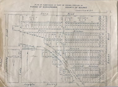
Plan - Subdivision Plan, Plan of Subdivision of Part of Crown Portion 84 / Parish of Boroondara / County of Bourke / Lodged Plan No. 2217, Twentieth Century
... Normanby Road...Lady Loch's Drive...Gladstone Street...Second Avenue...Subdivision plans -- Kew (Vic) Harp Road Burke Road Normanby Road Lady Loch's Drive Gladstone Street Second Avenue First Avenue Undated Plan of Subdivision of Crown Portion 84 in what is now Kew. ...Pru Sanderson, in her groundbreaking ‘City of Kew Urban Conservation Study : Volume 2 - Development History’ (1988), summarised the periods of urban development and subdivisions of land in Kew. The periods that she identified included 1845-1880, 1880-1893, 1893-1921, 1921-1933, 1933-1943, and Post-War Development. These periods were selected as they represented periods of rapid growth or decline in urban development. An obvious starting point for Sanderson’s groupings involved population growth and the associated economic cycles. These cycles also highlighted urban expansion onto land that was predominantly rural, although in other cases it represented the decline and breakup of large estates. A number of the plans in the Kew Historical Society’s collection can also be found in other collections, such as those of the State Library of Victoria and the Boroondara Library Service. A number are however unique to the collection.The Kew Historical Society collection includes almost 100 subdivision plans pertaining to suburbs of the City of Melbourne. Most of these are of Kew, Kew East or Studley Park, although a smaller number are plans of Camberwell, Deepdene, Balwyn and Hawthorn. It is believed that the majority of the plans were gifted to the Society by persons connected with the real estate firm - J. R. Mathers and McMillan, 136 Cotham Road, Kew. The Plans in the collection are rarely in pristine form, being working plans on which the agent would write notes and record lots sold and the prices of these. The subdivision plans are historically significant examples of the growth of urban Melbourne from the beginning of the 20th Century up until the 1980s. A number of the plans are double-sided and often include a photograph on the reverse. A number of the latter are by noted photographers such as J.E. Barnes.Undated Plan of Subdivision of Crown Portion 84 in what is now Kew. The area shown is bordered by Burke Road, Harp Road, Arglye Road and Normanby Road.subdivision plans -- kew (vic), harp road, burke road, normanby road, lady loch's drive, gladstone street, second avenue, first avenue -
 Kew Historical Society Inc
Plan, Kew! Kew!, 1888
... Avenue), and Belmore Road (now Harp Road). The 16 lots in the proposed subdivision are bisected by the route of the Outer Circle railway, and next to the proposed Normanby Station (later renamed East Kew). ...Avenue), and Belmore Road (now Harp Road). The 16 lots in the proposed subdivision are bisected by the route of the Outer Circle railway, and next to the proposed Normanby Station (later renamed East Kew). ...The Land Boom of the 1880s accelerated the rate of subdivisions in Kew. This subdivision, 'Kew! Kew!' was also impacted by, or resulted from, the decision by the Victorian Government to construct the Outer Circle railway. Construction of the railway began in 1888 and was completed in 1891. Plan of an 1888 subdivision bounded by Bulleen Road (now High Street), Gladstone Street (now Campbell Street?), Park Street (now Adeney Avenue), and Belmore Road (now Harp Road). The 16 lots in the proposed subdivision are bisected by the route of the Outer Circle railway, and next to the proposed Normanby Station (later renamed East Kew). On the plan, local landmarks such as the tram terminus, the Harp of Erin hotel, and the station are located. The street where the lots are numbered , was called Welsh Street on the plan as this was the name of the vendor. Surrounding land owners are also named: G. Smith Esq, Matthew Maher Esq, and Maurice Neligan Esq.outer circle railway, land subdivisions