
Showing 148 items matching " prices park"
-
 Glen Eira Historical Society
Book - CAULFIELD CENTENARY 1957
... ... Prices Park...Elections Political processes Local government Springthorpe Reserve Greenmeadows Gardens Business and finance Roads and streets Caulfield Racecourse East Caulfield Reserve Mackinnon Reserve Hawthorn Road Balaclava Road Murrumbeena Road Lempriere Avenue Victoria Street Koornang Road Lord Reserve Lyons Street Murrumbeena Reserve Kangaroo Road Ormond Park Beatty Crescent Foch Street Packer Reserve Oakleigh Road Leila Road Prices Park Bambra Road Riley Reserve Playgrounds Town Hall Maternal and child health centres Truganini Road Grange Road Senior Citizens centre Barkley Sir Henry Moore David Handasyde Gilbert Caulfield School Room Harris G.W. ...This file contains four items 1/Two copies of a twenty-four page booklet titled CITY OF CAULFIELD CENTENARY 1857-1957, created by the Caulfield City Council and printed by Peter Isaacson Pty Limited, Melbourne. The booklet details important aspects of Caulfield’s history including council procedures, the Caulfield Road District Proclamation, the first election and a summary of 100 years of local government with a description of the present Caulfield in 1957. The booklet also includes several pictures of various Caulfield landmarks and people including one of Caulfield City Councillors (11 men and 1 woman). Also one photocopied version of this booklet. 2/Eleven pages of typed notes for the City of Caulfield Centenary booklet. All notes are undated and incomplete. Two pages titled NOTES on THE HISTORY and PROGRESS OF THE CITY OF CAULFIELD, author unknown. Three and a half pages titled THE STRUCTURE OF LOCAL GOVERNMENT IN VICTORIA, author unknown. Five pages titled 100 YEARS OF LOCAL GOVERNMENT – EARLY CAULFIELD, by Mrs A. P. Bell. 3/A typed letter to Miss V. Webb-Langdon from the Town Clerk H.G. Nelson, acknowledging her contribution to historical details for the Caulfield Council’s Centenary booklet, dated 24/12/1957. 4/A handwritten letter and a handwritten note regarding the acquisition of notes for the Caulfield Centenary booklet. The letter is dated 03/08/2006 and the note is dated 09/02/2007.city of caulfield centenary, caulfield road district, sinclair a.j.g., city hall, war memorials, gamble h.a., machin l.r., bunny f.c.d., caulfield park, koornang reserve, parton e.m., sims h.e., thomson w.r., gunn e.e., yorston j.s., wallace g.e. mrs, green w.c., jenner e.r., ward boundaries, dandenong road, queens avenue, normanby road, station street, bond street, glen eira road, orrong road, poath road, north road, booran road, nepean highway, glen huntly road, glenhuntly road, inkerman road, hotham street, nelson h.g., fullard w.r., mackley g.j., ellis k.i, crosbie m.r., nutting b.i., body j.h., pritchard r.j., guildford l.t.g., lund l.m., street h.c., reynolds a.w., elections , political processes, local government, springthorpe reserve, greenmeadows gardens, business and finance, roads and streets, caulfield racecourse, east caulfield reserve, mackinnon reserve, hawthorn road, balaclava road, murrumbeena road, lempriere avenue, victoria street, koornang road, lord reserve, lyons street, murrumbeena reserve, kangaroo road, ormond park, beatty crescent, foch street, packer reserve, oakleigh road, leila road, prices park, bambra road, riley reserve, playgrounds, town hall, maternal and child health centres, truganini road, grange road, senior citizens centre, barkley sir henry, moore david, handasyde gilbert, caulfield school room, harris g.w., semple john, dempsey william, brooks w.a., wilson thomas, lyall william, murrum murrumbeen lifestyle, ‘greenmeadows’ house, lempriere family, aboriginal culture, ‘rippon lea’ house, caulfield john, ‘slaney’s’ home, alma road, paddy’s swamp, racecourse hotel, caulfield technical college, bevan mr., ‘grosmont’, hart john, railways, mansions, ‘rosecraddock’, langdon h. j., caulfield cup, ‘crotonhurst’, webb judge, ‘kilwinning’, service james, ricketson henry, ‘glen eira’, house names, garden vale, ross william murray, ‘ross’s folly’, outer circle railway, caulfield grammar school, davies j. henry, lagdon william, grimwade f.s., loyd charles du plan, hope george, ‘airdrie’, kooyong hill, market gardens, dairies, lady talbot milk supply, jenner family, o’niell college, presentation sisters, glenferrie road, grimwade frederick sheppard, grimwade alice, ‘harlston’, grimwade house, ‘saint aubin’s’, ‘st. aubin’s’, ‘caulfield hall’, caulfield john p.t., st georges road, caulfield military hospital, nursing homes, health establishments, dover street, sports and recreations, rosanna street, ‘cantala’, health services, parks and reserves, community services, town planning, local government finance, local officials and employees -
 Greensborough Historical Society
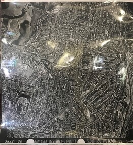
Aerial Photograph, Yan Yean M/S 7922 Run 17 No. 3833-20, 01/11/1984
... Covers Rosanna and parts of Viewbank and Heidelberg. East boundary Price Park; West boundary Hurstbridge railway line...Covers Rosanna and parts of Viewbank and Heidelberg. East boundary Price Park; West boundary Hurstbridge railway line rosanna viewbank heidelberg Laminated black and white aerial photograph; adjoins 6226 on east side Yan Yean M/S 7922 Run 17 No. 3833-20 Aerial Photograph ...Covers Rosanna and parts of Viewbank and Heidelberg. East boundary Price Park; West boundary Hurstbridge railway lineLaminated black and white aerial photograph; adjoins 6226 on east siderosanna, viewbank, heidelberg -
 Bendigo Historical Society Inc.
Document - BERT GRAHAM COLLECTION: BENDIGO EAST SWIMMING POOL
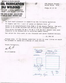
... Documents, Bert Graham Collection, Bendigo East Swimming Pool, from Morris & Nova Austin of EEL Fabrication DLI Welding submitting a quotation for supply and fit 1 pair of gates at Eastern Park, their price for this work is $1,700.00....BENDIGO Clubs bendigo east swimming pool Documents, Bert Graham Collection, Bendigo East Swimming Pool, from Morris & Nova Austin of EEL Fabrication DLI Welding submitting a quotation for supply and fit 1 pair of gates at Eastern Park, their price for this work is $1,700.00. Document BERT GRAHAM COLLECTION: BENDIGO EAST SWIMMING POOL. ...Documents, Bert Graham Collection, Bendigo East Swimming Pool, from Morris & Nova Austin of EEL Fabrication DLI Welding submitting a quotation for supply and fit 1 pair of gates at Eastern Park, their price for this work is $1,700.00.bendigo, clubs, bendigo east swimming pool -
 Federation University Historical Collection
Plan, Burrumbeep, 1884, 16/10/1884
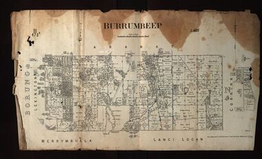
... price realised at auction was much more. Land was put up for sale in the study area on the Burrumbeep run in May 1855, on the Lexington run in 1857, and on the Gorrinn run in 1858. (http://www.ararat.vic.gov.au/library/document/thermatics.pdf, accessed 27 January 2015) For 70 years or more, Yalla-y-Poora, Burrumbeep, Edgarley, Mount William and Narrapumelap ranked in the leading wool producers in Victoria. 1 Stud owners at Yalla-y-Poora, Eurambeen, Burrumbeep and Challicum crossed merino sheep with sheep descended from John Macarthur's Camden Park in New South Wales. ...price realised at auction was much more. Land was put up for sale in the study area on the Burrumbeep run in May 1855, on the Lexington run in 1857, and on the Gorrinn run in 1858. (http://www.ararat.vic.gov.au/library/document/thermatics.pdf, accessed 27 January 2015) For 70 years or more, Yalla-y-Poora, Burrumbeep, Edgarley, Mount William and Narrapumelap ranked in the leading wool producers in Victoria. 1 Stud owners at Yalla-y-Poora, Eurambeen, Burrumbeep and Challicum crossed merino sheep with sheep descended from John Macarthur's Camden Park in New South Wales. ...Auctions of Crown land were introduced in the Colony of Victoria from 1851 to encourage settlers to occupy and work the land. Many squatters purchased land at auction at the upset (minimum) price of £1 per acre. In some areas where demand was high, such as the goldfields, the price realised at auction was much more. Land was put up for sale in the study area on the Burrumbeep run in May 1855, on the Lexington run in 1857, and on the Gorrinn run in 1858. (http://www.ararat.vic.gov.au/library/document/thermatics.pdf, accessed 27 January 2015) For 70 years or more, Yalla-y-Poora, Burrumbeep, Edgarley, Mount William and Narrapumelap ranked in the leading wool producers in Victoria. 1 Stud owners at Yalla-y-Poora, Eurambeen, Burrumbeep and Challicum crossed merino sheep with sheep descended from John Macarthur's Camden Park in New South Wales. (http://www.ararat.vic.gov.au/library/document/thermatics.pdf, accessed 27 January 2015) In what was to become the Ararat Mining Division, gold was discovered in May 1854 on the Burrumbeep run at a place that became known as Pinky Point on the Mount William goldfield. By 21 June 1854, between 600 and 1,000 people had arrived. (http://www.ararat.vic.gov.au/library/document/thermatics.pdf, accessed 27 January 2015)\ Town allotment plan for Burrumbeep. Merrymbuela, Borung, Lexington and Langi Logan are neighbouring areas. The plan includes the Burrumbeep Pre-Emptive Right (Roger and Wright); licensed land holders including Stephen Young, John Carroll, William Walsh, Thomas Purcell, Martha M. Bond, Colin Johnson, John Charles Webb, Henry Withycombe, William Henry Barbridge, John Wall, Thomas Flatelly, William Jenkinson, Elisia Radford, V. Radford, Denis Byrne, George Cook. Land holders included Andrew Maloney, Richard Wingfield Harrocks, W. Sporton, Terence Lynch, F. S. Falkiner, A. Millman, H. Morris, George Upham, J. McCLure, S. Fletcher, W. Parker, Thomas Myers, William wright, W.C. Winter, C. Wordman, Oliver A. Winter This plan is associated with former Ballarat School of Mines student Richard Squire (1875-6) Gift of the Squire FamilyVerso written in pencil - Plan of Burrembeep Ararat Burrembeep Araratburrumbeep, corrinn, langi logan, merrymbuela, lexington, ararat, roger & wright, cook, rogers, upham, george upham, ross, parsans, morris, johnson, withycoombe, colin johnson, falkiner, dsporton, john carroll, donald gordon, denis bryne, maurice dooley, martha bond, william harricks, \william wingfield harricks, william l.c. harricks, michael houlihan, thomas purcell, martin ryan, michael cody, fletcher, mccaw, w. parker, j.m. clow, elisia radford, thomas radford, thomas myers, barbridge, e. wilde, j. wall, flatelly, g. wardman, w.c. winter, david ball, jenkinson, ballarat school of mines, richard squire, squire -
 Marysville & District Historical Society
Document (Item) - Price list, Larry and Margaret Richmond, 2003
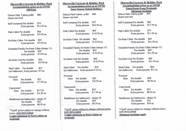
... park...accommodation...price...A list of accommodation prices as at July 1st, 2003 for the various facilities at the Marysville Caravan and Holiday Park....A list of accommodation prices as at July 1st, 2003 for the various facilities at the Marysville Caravan and Holiday Park....A list of accommodation prices as at July 1st, 2003 for the various facilities at the Marysville Caravan and Holiday Park. marysville victoria australia marysville caravan & holiday park accommodation price list A list of accommodation prices as at July 1st, 2003 for the various facilities at the Marysville Caravan and Holiday Park. ...A list of accommodation prices as at July 1st, 2003 for the various facilities at the Marysville Caravan and Holiday Park.A list of accommodation prices as at July 1st, 2003 for the various facilities at the Marysville Caravan and Holiday Park.marysville, victoria, australia, marysville caravan & holiday park, accommodation, price list -
 Flagstaff Hill Maritime Museum and Village
Photograph - Vessels, Sail and Steam Ships, c. 1972-1975
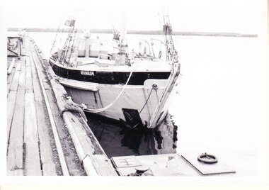
... Park Planning Board regarding the purchase a vessel suitable for use as an exhibit once Flagstaff Hill was opened. The Planning Board was set up by the Warrnambool Chamber of Commerce and approved by the City Council and State Government. Flagstaff Hill was investigating vessels in Adelaide and Tasmania as well as Melbourne. Andy looked at several vessels in 1972-1973. He also serviced the Reginald M among other vessels belonging to Captain Julian Dyson of Yarra Ferries, who had casually offered the vessel to Flagstaff Hill as a price...Park Planning Board regarding the purchase a vessel suitable for use as an exhibit once Flagstaff Hill was opened. The Planning Board was set up by the Warrnambool Chamber of Commerce and approved by the City Council and State Government. Flagstaff Hill was investigating vessels in Adelaide and Tasmania as well as Melbourne. Andy looked at several vessels in 1972-1973. He also serviced the Reginald M among other vessels belonging to Captain Julian Dyson of Yarra Ferries, who had casually offered the vessel to Flagstaff Hill as a price ...Andy Clapham owned and operated a boat yard on the Maribyrnong River in Footscray, Victoria. The river runs into Port Phillip Bay (sometimes known as Hobson’s bay) at Williamstown, an area with a history of trades associated with the shipping and construction industry. Andy Clapham’s photographs include those of the Reginald M and one of Polly Woodside, another vessel restored and used as a maritime exhibition. Andy Clapham’s letter of 1972 was posted in a and envelope with an early Australian decimal currency stamp showing the profile portrait of Queen Elizabeth II, and valued at 7 cent. Andy offered invaluable advice to the Flagstaff Hill Historic Park Planning Board regarding the purchase a vessel suitable for use as an exhibit once Flagstaff Hill was opened. The Planning Board was set up by the Warrnambool Chamber of Commerce and approved by the City Council and State Government. Flagstaff Hill was investigating vessels in Adelaide and Tasmania as well as Melbourne. Andy looked at several vessels in 1972-1973. He also serviced the Reginald M among other vessels belonging to Captain Julian Dyson of Yarra Ferries, who had casually offered the vessel to Flagstaff Hill as a price that was unattainable at the time. Flagstaff Hill later requested photographs of the hull to discern the dimensions and also the condition of the timbers as well as wanting advice on its seafaring capability. In 1972 the Flagstaff Hill Historic Park Planning Board – Chairman J. (John) S. Lindsay (1972-1980), Secretary J. (James) Mark – wrote a letter of appreciation to Mr A. (Andy) Clapham of 3 Charles Street Footscray ... “Dear Mr. Clapham, The Board has asked me to write to you to express our appreciation for the assistance you have offered us through our Chairman John Lindsay. The information you have already given us has been invaluable, in that is shows us that we have not been setting out to do something that is impossible. We look forward to receiving further information from you as it becomes available and we appreciate that you must be busy enough without our problems. Members of our Board hope to call and see you on a trip to Melbourne in the near future. The Board is optimistic about the future of Flagstaff Hill as a Maritime Museum and look forward to you visiting Warrnambool to examine what we believe will be an ideal site. Yours faithfully, James Mark.” ABOUT the vessel “Reginald M” The vessel “Reginald M” was a two-masted, timber coastal vessel built by John Henry Murch in Birkenhead, Port of Adelaide, South Australia. It was named after Reginald Murch. (It was occasionally referred to as the Reginald “Emm”). Its construction took approximately 6 months using many materials and fittings from salvage yards. It is believed that the keep was hewn from two telegraph poles! Reginald M was launched at Largs Bay in 1922. Reginald M was approximately 30 metres long and was fore-to-aft ketch rigged with an ‘auxiliary’ motor to support any loss of sail power. The Reginald M was built to service the coastal ports of South Australia to Port Victoria on the York Peninsular, Spencer Gulf. It freighted cargo from port to port cheaply and efficiently. It had a very shallow draft and a flat bottom, enabling it to come close to shore and sit high and dry at low tide, or to be beached on the sand. It could easily skim over reefs due to its flat bottom. Wagons could be loaded and unloaded directly from the side of the vessel. Over the years her cargo included guano, barley, wool, horses, cattle, timber, explosives, potatoes, shell grit and gypsum. The Murch brothers from Port Adelaide were owners of the Reginald M and Richard Murch as the Captain. On April 9, 1931, Reginald M weathered a large storm in St. Vincents Gulf, SA, suffering much damage; the mast snapped and the crew laboured for four hours to free it up by severing the mast and rigging. The crew patched it up and slowly returned to Port Adelaide with only a portion of the insured cargo being damaged. The crew members at that time were owner Mr John Henry Murch of Wells Street Largs Bay, Skipper Mr R Murch – John’s brother, Murray – son of Captain Murch and Seaman John Smith. At some stage it seems that the Reginald M was used as a Customs vessel “H.M.C. No. 3, Pt Adelaide” as shown in a photograph in Flagstaff Hill’s collection. In 1969 Reginald M’s last freight trip left Marion Bay, carrying grain, wool and explosives. In late 1970 it was sold to the Mount Lyall Mining and Railway Clompany and used as a barge to carry explosives. In 1972 The Navy League of Strahan, Tasmania, purchased the vessel for use by the Strahan Sea Cadet Unit at Macquarie Harbour; it was renamed “T.S. Macquarie”. (This plan did not come to pass.) In 1974 Mr Andrew Rennie of East Brighton, Melbourne, brought Reginald M for shipping purposes, He sailed it from Strahan to Melbourne, planning to use it for pleasure sailing. The Reginald M was later sold at auction to Captain Julian Dyson, owner of Yarra Passenger Ferries in Melbourne. Later in 1975 funds became available to Flagstaff Hill Maritime Village to purchase the Reginald M. It was then restored and used as an exhibit here for many hears. Flagstaff Hill’s collection also includes various objects related to the Reginald M: - Photographs of Reginald M over the years in various aspects of its use - a life buoy with the inscription of “Pt. Adelaide” - helm section that was removed and replaced during restoration - a bullet found in pieces of timber during the 1979 restoration ABOUT THE POLLY WOODSIDE On the bow in the Polly Woodside's photograph is the word "RONA". the Polly Woodside was built at Belfast in 1885. In 1904 the vessel was sold to A.H. Turnbull of New Zealand and renamed "RONA". The letter and photographs are significant for their association with the Reginald M, an Australian built coastal trader now on the Australian Register of Historic Vessels (number HV000562). The letter and photographs are also significant as part of both the history of Flagstaff Hill and the history of the vessel “Reginald M” that has been on display in the lake for many years. Objects retained from this boat are included in Flagstaff Hill’s collection of maritime history.Packet with photographs and negatives in a KODAK envelope. The photographs are of two sail and steam vessels; twelve (12) black and white photographs of the 'Reginald M', and one (1) colour photograph of the Polly Woodside, plus six (6) negative strips. Included int he packet is a letter in stamped and postmarked envelope addressed to Mr A Clapham of Footscray. The envelope postmarked 9 Dec 1972, with the Warrnambool postcode 3280, A 7c Australian postage stamp in attached to the envelope. They are associated with Flagstaff Hill’s acquisition of the vessel “Reginald M”. Envelope "9 DEC 1972 / 3280" Postage stamp "7c" "Australia" Inscriptions on one Reginald M;; "REGINALD M" and "Pt ADELAIDE H.M.C. No. 3" Inscriptions of the Polly Woodside; "RONA / MSC" "MHI / NO. 1" Ball point ink, reverse of photograph "POLLY WOODSIDE"flagstaff hill, warrnambool, shipwrecked coast, flagstaff hill maritime museum, maritime museum, shipwreck coast, flagstaff hill maritime village, great ocean road, vessel reginald m, reginald emm, t. s. macquarie, h.m.c. no. 3, pt adelaide, australian register of historic vessels (number hv000562), boat building trade, jack murch, john henry murch, birkenhead, port adelaide sa, largs bay sa, coastal trader south australia, 1920 ketch reginald m, marion bay produce, mount lyall mining and railway company, navy league of strahan, tasmania, melbourne ferry company, flagstaff hill historic park planning board, john lindsay, james mark, andy clapham of footscray, andy clapham boat builder, kodak photograph packet envelope, kodak super-size prints, kodak australia pty ltd, australian postage stamp 1972 - 7c -
 City of Moorabbin Historical Society (Operating the Box Cottage Museum)
Photograph - Map of Dendy's Special Survey, 1852 Map of Henry Dendy's Special Survey of 1841, 19th Century
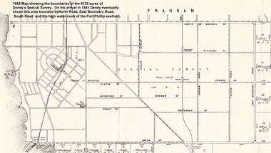
... price of the land. Dendy appointed Jonathan Were, (an entrepreneur, who had arrived in 1839), as his Manager and who later became a partner. Together, Dendy and Were decided on an area 5 miles south from Melbourne, bounded by North Road, East Boundary Road, South Road and to the west by Port Phillip Bay. Were and Dendy pitched their tents in the area now known as ' Park...price of the land. Dendy appointed Jonathan Were, (an entrepreneur, who had arrived in 1839), as his Manager and who later became a partner. Together, Dendy and Were decided on an area 5 miles south from Melbourne, bounded by North Road, East Boundary Road, South Road and to the west by Port Phillip Bay. Were and Dendy pitched their tents in the area now known as ' Park ...A Map drawn in 1852 that shows the 5,120 acres that formed Dendy's Special Survey of 1841. In 1840 Henry Dendy, a farmer in Surrey, England acquired a "Special Survey" from the Commissioners for Land and Emigration which gave Dendy the right to choose land in Port Phillip for the "bargain basement" price of only £1 per acre for 5120 acres, (an area of 8 square miles). The Special Survey also included the right to "the shipment of a worker for every £20 spent on land, whose free passage was paid by the Crown, equalling a total of 100 workers ". Accordingly Dendy sold his English holdings and paid the required £5120 and arrived in Melbourne in February 1841. However by this time land in the new colony was selling for £5 - £40 per acre. Because Henry Dendy possessed the order from the Colonial Office in London he was able to successfully oppose Governor LaTrobe's attempts to alter the price of the land. Dendy appointed Jonathan Were, (an entrepreneur, who had arrived in 1839), as his Manager and who later became a partner. Together, Dendy and Were decided on an area 5 miles south from Melbourne, bounded by North Road, East Boundary Road, South Road and to the west by Port Phillip Bay. Were and Dendy pitched their tents in the area now known as ' Park St, Brighton' and sank a well near the corner of 'St Andrew's St and Wells St'. By 1845 J.B Were and Company had bought almost half of Dendy's land and Were built himself "Moorabbin House" in Were St Brighton made from stone, quarried from local cliffs. It was still standing in 1924. Legend records Moorabbin is named after the Aboriginal word for ' Mother's Milk ' The soil is very fertile and well supplied with water especially in the area called 'East Brighton' - now known as Bentleigh and East Bentleigh - By 1850 the area had developed with numerous market gardens, dairy farms, fruit gardens and vineyards supplying food for the growing population of Melbourne.This Map shows the birth of the Brighton and Moorabbin area. On 18th January1859 Brighton was proclaimed a Municipality and a Borough by October 1863. Meanwhile, following a Petition, the area of East and South Brighton, incorporating Mordialloc, Cheltenham, Mentone, Sandringham and Oakleigh separated from Brighton to form the Moorabbin District Roads Board becoming the first Local Government Authority. Col. William Mair was elected as the first Chairman of the Moorabbin Roads Board. Moorabbin Shire 1871 developed further and was declared a City in1934. The City of Moorabbin was the largest Municipality in Melbourne before the Amalgamation of Councils in 1994 when it was divided in the south to City of Kingston and in the north to City of Glen Eira A Photo-lithographed 1852 Map showing the 5,120 acres that formed Dendy's Special Survey of 1841. Henry Dendy & Jonathan Were chose an area 5 miles south from Melbourne, bounded by North Road, East Boundary Road, South Road and to the west by Port Phillip Bay. Moorabbin County of Bourke / Photo-Lithographed at the department of Lands and Survey. /Melbourne. / Price 1/- brighton, moorabbin, bentleigh, cheltenham, dendy henry, bent thomas, were jonathan, special survey -
 Ringwood and District Historical Society
Flyer, Subdivisional Land Sale Brochure, Rozelle Park Estate, Ringwood East, Vic. - circa 1968
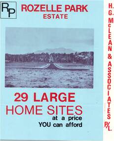
... Separate price list leaflet enclosed with terms of sale. Subdivisional Land Sale Brochure, Rozelle Park Estate, Ringwood East, Vic. - circa 1968 Flyer ...Folded land subdivision sale advertisement for 29 home sites, with location map and summary of local facilities and services. Separate price list leaflet enclosed with terms of sale.Subdivision includes Wingate Avenue and Rozelle Avenue, Ringwood East. Agent - H.G. McLean & Associates Pty. Ltd., 166 Canterbury Road, Heathmont. Phone 870 3422 A/H 870 5879. -
 Ringwood and District Historical Society
Plan, Residential Land Sale Sub-division
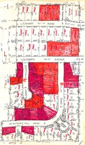
... price annotations. Subdivision includes Lockhart Road, Goldsmith Avenue, Albany Close and Park Hill Drive....price annotations. Subdivision includes Lockhart Road, Goldsmith Avenue, Albany Close and Park Hill Drive. ...Subdivision map of 60 residential allotments for sale in North Ringwood, Vic., circa 1968, with handwritten asking price annotations. Subdivision includes Lockhart Road, Goldsmith Avenue, Albany Close and Park Hill Drive. -
 Ringwood and District Historical Society
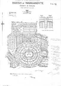
Document - Subdivision Map, Part of Crown Sections 18, 19, 24 & 25, Parish of Warrandyte, County of Evelyn, Vol 5228 Fol 472 - 1926. (Park Orchards, Victoria)
... Park Orchards, Victoria. A3 and A4 sized photocopies showing map section of land title showing streets, easements and allotment numbers, some with handwritten names and pricing notations circa mid 1950s. ...A3 and A4 sized photocopies showing map section of land title showing streets, easements and allotment numbers, some with handwritten names and pricing notations circa mid 1950s.Map includes Valley Road, Granard Avenue, Park Road, Arundel Avenue, Hylton Avenue, Aviemore Avenue, Bowmore Avenue, Hopetoun Road, Colin Avenue, Daintree Avenue, Brucedale Crescent, Feversham Avenue, Ennismore Crescent, Iona Grove, Elgin Crescent and Gosford Crescent, Park Orchards, Victoria. -
 Ringwood and District Historical Society
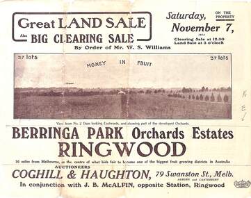
Pamphlet - Auction Sale, Berringa Park Orchards Estate, Ringwood, Victoria - 1914
... Three-page Park Orchards Estate Price List attached....Three-page Park Orchards Estate Price List attached. Berringa Park Orchards Estate, Ringwood, Victoria - 1914 Pamphlet Auction Sale ...Multi-fold brochure advertising public auction of 37 lots on Saturday 7th November, 1914. Brochure includes terms of sale, description of subdivision features and local facilities, and photographic images of the area. Three-page Park Orchards Estate Price List attached.Subdivison includes Smedley Road, Oban Road, Berringa Road, and Williams Road, North Ringwood. Auctioneers: Coghill & Haughton, 79 Swanston Street, Melbourne, in conjunction with J.G. McAlpin, Ringwood. Brochure includes Clearing Sale to be held same day for "everything required to work these orchards, from a packing needle to a traction engine ... comprising the most up-to-date and extensive farm & chaffcutting plant in this great district". -
 Ringwood and District Historical Society
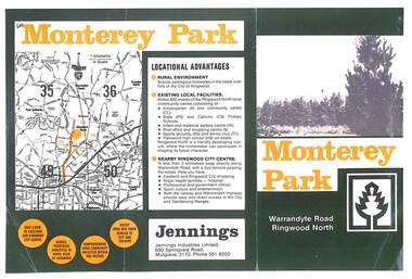
Document - Folder, Land Sale - Monterey Park Subdivision, Warrandyte Road, Ringwood North, Vic. - 1981
... Park streets. Subdivision includes Parkwood High School, Tortice Drive, Heape Way, Appleberry Place, Stringybark Court, Conifer Court, Crawley Grove, Monterey Close (later Monterey Place), Lucy Place, Middlebrook Drive, Gahnia Close, Glanfield Court, Cone Close, Jull Parade, Pinus Close (later Pinetree Court), Radiata Close, Old Warrandyte Road, and entry from Warrandyte Road. Vendor - Jennings Industries Limited, 690 Springvale Road, Mulgrave, 3170, Phone 5618000. A4 enclosures with tables showing each allotment List Price...Price. Information page headed "Form of Restrictive Covenant to be incorporated in Transfer" specific to Certificates of Title. Land Sale - Monterey Park ...Foolscap manilla folder containing double-sided flyer advertising residential subdivision development, including outline of local facilities and services, with locality map and layout of Monterey Park streets. Subdivision includes Parkwood High School, Tortice Drive, Heape Way, Appleberry Place, Stringybark Court, Conifer Court, Crawley Grove, Monterey Close (later Monterey Place), Lucy Place, Middlebrook Drive, Gahnia Close, Glanfield Court, Cone Close, Jull Parade, Pinus Close (later Pinetree Court), Radiata Close, Old Warrandyte Road, and entry from Warrandyte Road. Vendor - Jennings Industries Limited, 690 Springvale Road, Mulgrave, 3170, Phone 5618000. A4 enclosures with tables showing each allotment List Price, Builders Price, Cash Price and Terms Price. Information page headed "Form of Restrictive Covenant to be incorporated in Transfer" specific to Certificates of Title. Restrictive Covenant (summary): (Name/s) "... will not erect or construct or cause to be erected or constructed on the land hereby transferred (a) Any front boundary fence, other than a fence which does not exceed one metre in height unless the same is set back as least 1.5 metres from the front boundary and the same is effectively screened from that boundary by the planting of trees, shrubs or plants. (b) Any side boundary fence other than a fence which is set back at least 1.5 metres from the front boundary on which does not exceed 1 metre in height within 1.5 metres of the front boundary. (c) For a period of 5 years from the date hereof, any building on the said land unless and until the Plans and Specifications thereof have first been approved by the said Residential Developments Pty. Limited. (d) For a period of 2 years from the date hereof whilst the said land remains vacant any Signboard or Notice advertising the sale of the said lot or any other lot. These covenants shall appear on the Certificate of Title to issue for the said land and run with the land." -
 Ringwood and District Historical Society
Flyer, Residential Land Sale Brochure, Peppermint Park, Heathmont, Vic. - 2010
... Handwritten price list notations included, and Stage 2 Plan digitally signed by Michael Herwald Hipfel, Licensed Surveyor, 10/2/1916. Double-sided A3 size advertisement for Peppermint Park, Heathmont, Victoria, advertising sale of ten homesites with diagram showing locality map, size of blocks and layout of streets within and around the subdivision. ...Double-sided A3 size advertisement for Peppermint Park, Heathmont, Victoria, advertising sale of ten homesites with diagram showing locality map, size of blocks and layout of streets within and around the subdivision.Subdivision layout includes Pleasant Drive, Swain Court and Barbara Court off Culverlands Road and Armstrong Road in Heathmont. Agents - Carter Real Estate Agency, 90 Maroondah Highway, Ringwood Vic 3134 (Telephone) 98706211. Auctioneers - Richard Carter & William Lyall - 0411823337. Handwritten price list notations included, and Stage 2 Plan digitally signed by Michael Herwald Hipfel, Licensed Surveyor, 10/2/1916. -
 City of Moorabbin Historical Society (Operating the Box Cottage Museum)
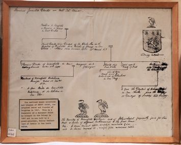
Document - Genealogy Chart Henry Dendy (Photocopy), 19 thC
... price of the land. Dendy appointed Jonathan Were, (an entrepreneur, who had arrived in 1839), as his Manager and who later became a partner. Together, Dendy and Were decided on an area 5 miles south from Melbourne, bounded by North Road, East Boundary Road, South Road and to the west by Port Phillip Bay. Were and Dendy pitched their tents in the area now known as ' Park...price of the land. Dendy appointed Jonathan Were, (an entrepreneur, who had arrived in 1839), as his Manager and who later became a partner. Together, Dendy and Were decided on an area 5 miles south from Melbourne, bounded by North Road, East Boundary Road, South Road and to the west by Port Phillip Bay. Were and Dendy pitched their tents in the area now known as ' Park ...In 1840 Henry Dendy, a farmer in Surrey, England acquired a "Special Survey" from the Commissioners for Land and Emigration which gave Dendy the right to choose land in Port Phillip for the "bargain basement" price of only £1 per acre for 5120 acres, (an area of 8 square miles). The Special Survey also included the right to "the shipment of a worker for every £20 spent on land, whose free passage was paid by the Crown, equalling a total of 100 workers ". Accordingly Dendy sold his English holdings and paid the required £5120 and arrived in Melbourne in February 1841. However by this time land in the new colony was selling for £5 - £40 per acre. Because Henry Dendy possessed the order from the Colonial Office in London he was able to successfully oppose Super-intendant LaTrobe's attempts to alter the price of the land. Dendy appointed Jonathan Were, (an entrepreneur, who had arrived in 1839), as his Manager and who later became a partner. Together, Dendy and Were decided on an area 5 miles south from Melbourne, bounded by North Road, East Boundary Road, South Road and to the west by Port Phillip Bay. Were and Dendy pitched their tents in the area now known as ' Park St, Brighton' and sank a well near the corner of 'St Andrew's St and Wells St'. By 1845 J.B Were and Company had bought almost half of Dendy's land and Were built himself "Moorabbin House" in Were St Brighton made from stone, quarried from local cliffs. It was still standing in 1924. Legend records Moorabbin is named after the Aboriginal word for ' Mother's Milk ' The soil is very fertile and well supplied with water especially in the area called 'East Brighton' - now known as Bentleigh and East Bentleigh - By 1850 the area had developed with numerous market gardens, dairy farms, fruit gardens and vineyards supplying food for the growing population of Melbourne.In 1840 Henry Dendy, a farmer in Surrey, England acquired a "Special Survey" from the Commissioners for Land and Emigration which gave Dendy the right to choose land in Port Phillip for the price of only £1 per acre for 5120 acres. This land was called Brighton in the Parish of Moorabbin, County of Bourke and emigrants developed the land establishing market gardens , dairy and poultry farms that provided the food for the growing population of Melbourne. A photocopy of the Genealogy Chart of the Dendy Family that Henry Dendy brought with him when he emigrated to Melbourne 1841Genealogy signs and descriptionsdendy henry, dendy's special survey brighton 1841, governor gipps, captain lonsdale, super-intendant latrobe, port phillip, melbourne, new south wales, squatters, emmigrants, county of bourke, parish of moorabbin, early settlers, pioneers, market gardeners, dairy farmers, fruit farms, moorabbin, bentleigh, brighton, cheltenham, were jonathan binn, -
City of Moorabbin Historical Society (Operating the Box Cottage Museum)
Document, Henry Dendy family Shield
... price of the land. Dendy appointed Jonathan Were, (an entrepreneur, who had arrived in 1839), as his Manager and who later became a partner. Together, Dendy and Were decided on an area 5 miles south from Melbourne, bounded by North Road, East Boundary Road, South Road and to the west by Port Phillip Bay. Were and Dendy pitched their tents in the area now known as ' Park...price of the land. Dendy appointed Jonathan Were, (an entrepreneur, who had arrived in 1839), as his Manager and who later became a partner. Together, Dendy and Were decided on an area 5 miles south from Melbourne, bounded by North Road, East Boundary Road, South Road and to the west by Port Phillip Bay. Were and Dendy pitched their tents in the area now known as ' Park ...In 1840 Henry Dendy, a farmer in Surrey, England acquired a "Special Survey" from the Commissioners for Land and Emigration which gave Dendy the right to choose land in Port Phillip for the "bargain basement" price of only £1 per acre for 5120 acres, (an area of 8 square miles). The Special Survey also included the right to "the shipment of a worker for every £20 spent on land, whose free passage was paid by the Crown, equalling a total of 100 workers ". Accordingly Dendy sold his English holdings and paid the required £5120 and arrived in Melbourne in February 1841. However by this time land in the new colony was selling for £5 - £40 per acre. Because Henry Dendy possessed the order from the Colonial Office in London he was able to successfully oppose Super-intendant LaTrobe's attempts to alter the price of the land. Dendy appointed Jonathan Were, (an entrepreneur, who had arrived in 1839), as his Manager and who later became a partner. Together, Dendy and Were decided on an area 5 miles south from Melbourne, bounded by North Road, East Boundary Road, South Road and to the west by Port Phillip Bay. Were and Dendy pitched their tents in the area now known as ' Park St, Brighton' and sank a well near the corner of 'St Andrew's St and Wells St'. By 1845 J.B Were and Company had bought almost half of Dendy's land and Were built himself "Moorabbin House" in Were St Brighton made from stone, quarried from local cliffs. It was still standing in 1924. Legend records Moorabbin is named after the Aboriginal word for ' Mother's Milk ' The soil is very fertile and well supplied with water especially in the area called 'East Brighton' - now known as Bentleigh and East Bentleigh - By 1850 the area had developed with numerous market gardens, dairy farms, fruit gardens and vineyards supplying food for the growing population of Melbourne. dendy henry, dendy's special survey brighton 1841, governor gipps, captain lonsdale, super-intendant latrobe, port phillip, melbourne, new south wales, squatters, emmigrants, county of bourke, parish of moorabbin, early settlers, pioneers, market gardeners, dairy farmers, fruit farms, moorabbin, bentleigh, brighton, cheltenham, were jonathan binn, -
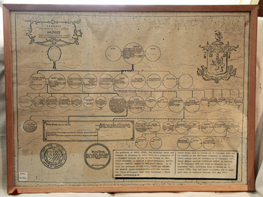 City of Moorabbin Historical Society (Operating the Box Cottage Museum)
Document - Pedigree of Henry Dendy, c1840 Original ; Copy 1985
... price of the land. Dendy appointed Jonathan Were, (an entrepreneur, who had arrived in 1839), as his Manager and who later became a partner. Together, Dendy and Were decided on an area 5 miles south from Melbourne, bounded by North Road, East Boundary Road, South Road and to the west by Port Phillip Bay. Were and Dendy pitched their tents in the area now known as ' Park...price of the land. Dendy appointed Jonathan Were, (an entrepreneur, who had arrived in 1839), as his Manager and who later became a partner. Together, Dendy and Were decided on an area 5 miles south from Melbourne, bounded by North Road, East Boundary Road, South Road and to the west by Port Phillip Bay. Were and Dendy pitched their tents in the area now known as ' Park ...This is a copy of the document brought by Henry Dendy to the Colony in 1841. In 1840 Henry Dendy, a farmer in Surrey, England acquired a "Special Survey" from the Commissioners for Land and Emigration which gave Dendy the right to choose land in Port Phillip for the "bargain basement" price of only £1 per acre for 5120 acres, (an area of 8 square miles). The Special Survey also included the right to "the shipment of a worker for every £20 spent on land, whose free passage was paid by the Crown, equalling a total of 100 workers ". Accordingly Dendy sold his English holdings and paid the required £5120 and arrived in Melbourne in February 1841. However by this time land in the new colony was selling for £5 - £40 per acre. Because Henry Dendy possessed the order from the Colonial Office in London he was able to successfully oppose Super-intendant LaTrobe's attempts to alter the price of the land. Dendy appointed Jonathan Were, (an entrepreneur, who had arrived in 1839), as his Manager and who later became a partner. Together, Dendy and Were decided on an area 5 miles south from Melbourne, bounded by North Road, East Boundary Road, South Road and to the west by Port Phillip Bay. Were and Dendy pitched their tents in the area now known as ' Park St, Brighton' and sank a well near the corner of 'St Andrew's St and Wells St'. By 1845 J.B Were and Company had bought almost half of Dendy's land and Were built himself "Moorabbin House" in Were St Brighton made from stone, quarried from local cliffs. It was still standing in 1924. Legend records Moorabbin is named after the Aboriginal word for ' Mother's Milk ' The soil is very fertile and well supplied with water especially in the area called 'East Brighton' - now known as Bentleigh and East Bentleigh - By 1850 the area had developed with numerous market gardens, dairy farms, fruit gardens and vineyards supplying food for the growing population of Melbourne. A copy of a paper chart of the Pedigree of Henry Dendy in a wooden frame with glassPedigree / of the branch of the family / DENDY moorabbin, brighton, henry dend special survey 1841 y, early settlers, pioneers, market gardeners -
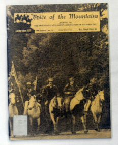 Orbost & District Historical Society
journal, E-Gee Printers, Voice of the Mountains, 1986
... Park". It is titled :"Voice of the Mountains, Journal of the Mountain District Cattlemen's Association of Victoria Inc., 1986 Edition no 10" and is priced at $4.00. ...Park". It is titled :"Voice of the Mountains, Journal of the Mountain District Cattlemen's Association of Victoria Inc., 1986 Edition no 10" and is priced at $4.00. ..."The Association was officially launched in November 1967 with the aim of preserving and maintaining good relations and understanding within the cattle industry and between that industry and all bodies and organisations with which the industry is associated in the spheres of Government, and land use and marketing." (ref Mountain Cattlemen's Association web-site) Since 1972, the Mountain Cattlemen’s Association of Victoria, have produced a journal, “The Voice of the Mountains”. This journal commemorates the activities and history of the previous twelve months and bygone years of cattlemen and their families. This item was used in the library of Orbost Secondary College. The journals form a part of Victoria’s history and are a useful research tool.A 44 pp book covered in clear contact. It has a brown cover with a photograph , "On the Road to Ringwood - protest ride against the establishment of Alpine national Park". It is titled :"Voice of the Mountains, Journal of the Mountain District Cattlemen's Association of Victoria Inc., 1986 Edition no 10" and is priced at $4.00. journal-voice-of-the-mountains cattlemen-history cattle-industry -
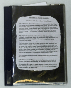 Orbost & District Historical Society
folder, Historical Flood Marker, 1999 - 2001
... Park, Orbost. Most photographs and printed text are glued in. There are twelve loose photographs.The front cover and spine are dark blue, the back is a lighter blue and has a bar code and price sticker attached....Park, Orbost. Most photographs and printed text are glued in. There are twelve loose photographs.The front cover and spine are dark blue, the back is a lighter blue and has a bar code and price sticker attached. ...This folder contains a record of the construction of the flood marker in Forest Park, Orbost. It depicts the six highest floods since the first recording. The construction of the marker was commenced in August 1999 and took eighteen months to be completed by nine volunteers under the tutelage of Ruth Hansen.This item is a contemporary record of the construction of an iconic marker in Orbost.A loose leaf folder containing information, records and photographs about the Historic Flood Marker in Forest Park, Orbost. Most photographs and printed text are glued in. There are twelve loose photographs.The front cover and spine are dark blue, the back is a lighter blue and has a bar code and price sticker attached.flood-marker-orbost -
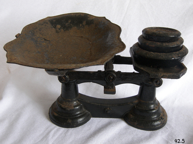 Flagstaff Hill Maritime Museum and Village
Instrument - Balance Scale, Henry Crane (Crane Foundry), 1870-1900
... Parkes & Sons Limited, Willenhall became a majority shareholder. Things were going well until the company’s liabilities spiraled out of control with the rise in electricity and gas prices along with the loss of two of the company’s largest customers. ...Parkes & Sons Limited, Willenhall became a majority shareholder. Things were going well until the company’s liabilities spiraled out of control with the rise in electricity and gas prices along with the loss of two of the company’s largest customers. ...The Crane foundry opened some time before 1827 and was known as Atherton’s Foundry, run by James Atherton and Henry Crane. Initially it was a brass foundry, but by 1827 iron castings were also produced on the site. The main products were castings for the building industry, ironmongery and brassware. In the 1830s castings for the hand tool and lock industries were added to the product range and by 1836 Henry Crane had taken control of the business. The company became known as the Crane Foundry in 1847 with its own registered trademark. By the 1850s iron weights were produced, and a design was registered in 1872 with roundels decorating the edge. Brass weights were also produced, mainly after the regulation of 1890 that required weights of 2oz. or less to be made of brass. In the early 1900s the foundry began to produce castings for electric motors and continued to do so throughout its life. The Crane family continued to control the company until 1917 when William Cyril Parkes of lock makers Josiah Parkes & Sons Limited, Willenhall became a majority shareholder. Things were going well until the company’s liabilities spiraled out of control with the rise in electricity and gas prices along with the loss of two of the company’s largest customers. The factory went into liquidation and then closed in 2006 an end to one of Wolverhampton’s oldest companies.An item made by one of England's foundry’s based in Wolverhampton that exported items all over the world for many years. The scale gives a snapshot into the commercial life not only of England by Australian colonial life before Federation.Beam scale with three weights (4lb, 2lb, 1lb), metal tray, corrodedMarked on 2lb weight "Wolverhampton Crane Foundry" flagstaff hill, warrnambool, flagstaff hill maritime museum, shipwreck coast, flagstaff hill maritime village, great ocean road, scale, beam scale, pounds and ounces, imperial weight, grocers scale, domestic scale, henry crane, crane foundry -
Ringwood and District Historical Society
Document, Property Research Notes - The History of 18 Vista Avenue, Ringwood East, Victoria
... price was £1000. Mr Boyd became sick not long after acquiring the land and offered the property, then a bush block, to Dr Arthur G Stephens. Dr Stephens purchased the block for £2,500 in 1959. The block was not immediately built on. Dr and Mrs Stephens said they were not able to afford a new building on the Vista Avenue block at the time, so relocated their house from 302 Maroondah Highway, near the current site of the Maroondah City Council, to the current location on the block. The garden design was created by Gloria Parker from Park...price was £1000. Mr Boyd became sick not long after acquiring the land and offered the property, then a bush block, to Dr Arthur G Stephens. Dr Stephens purchased the block for £2,500 in 1959. The block was not immediately built on. Dr and Mrs Stephens said they were not able to afford a new building on the Vista Avenue block at the time, so relocated their house from 302 Maroondah Highway, near the current site of the Maroondah City Council, to the current location on the block. The garden design was created by Gloria Parker from Park ...Single A4 page summary of the house and land prepared for real estate purposes by un-named author, undated, circa 1990s.The History Of 18 Vista Avenue, Ringwood East The Land The current block located at 18 Vista Avenue was originally part of an 80 acre block granted to R Blood on 12 March 1872. A Wallace Bruce subsequently sold off a portion of this land and on it the Davies family erected the house "Reaghill" shortly after 1909. A 35 acre parcel of this original block was subdivided into 22 lots in June 1955. The subdivision consisted of 15 lots from 1½ and 2½ acres and seven smaller blocks of about ½ acre fronting Bedford Road. The 18 Vista Avenue block, then just over 2 acres was purchased by Mr Campbell Boyd, a local pharmacist, in 1956. The purchase price was £1000. Mr Boyd became sick not long after acquiring the land and offered the property, then a bush block, to Dr Arthur G Stephens. Dr Stephens purchased the block for £2,500 in 1959. The block was not immediately built on. Dr and Mrs Stephens said they were not able to afford a new building on the Vista Avenue block at the time, so relocated their house from 302 Maroondah Highway, near the current site of the Maroondah City Council, to the current location on the block. The garden design was created by Gloria Parker from Park Orchards and included a variety of roses and unusual species of plants. The House The house which was built in 1959, was successfully moved in two pieces in 1972, from Maroondah Highway, under the railway crossing at Ringwood East and up Scenic Avenue. The route through the railway crossing on Dublin Road required the removal of the top four feet of roof from the building so it would fit under the overhead wires. The building was cut along the entrance hall and when put together the join was barely perceptible. The saw cuts on each side of the house when rejoined, were said to have matched exactly. There were originally two brick fireplaces in the house, one in the lounge (an Adams design) and the second in the library. The library fireplace was not reconstructed after the house was relocated. The bricks and bluestone slabs, which form a substantial part of the structure of the formal garden around the house, were salvaged from the demolition of the Burnt Bridge Hotel. Dr Stephens bought 32 truckloads of uncleaned bricks from the demolition contractor for $1 per load. Presumably the demolition contractor had already been paid to demolish, remove and dump the building rubble by the developer of the Burnt Bridge shopping centre and now was able to on-sell the bricks without the cost of disposal. These bricks make up the first three feet of the brick wall which encompasses the secret garden. This wall originally marked the start of a terraced area which extended back to the Vista Avenue road frontage. The large bluestone slabs making up most of the steps in the garden were the door steps on the old hotel and the large square roughmade bricks were originally the foundation stones for the stumps of the Burnt Bridge building. The terraced area and land to the south of the tennis court (the current 16A to 16E Vista Avenue) was sold off to Bovis Homes after the nine year covenant expried on the land. -
 Ringwood and District Historical Society
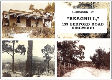
Archive, Richard Carter Collection - REAGHILL Subdivision Research (Parent Record)
... price paid for Lot 13 in 1957. The Role of Frank Leslie Walker These notes have so far recorded that of the sixty acres originally owned by Wallace Bruce in 1900, some 34.875 acres were sold to Dora Davies in 1909 and subdivided and sold by her descendants. The balance of Wallace Bruce’s land was sold on 6th April 1914 to Frank Leslie Walker. This is the land at the south east corner of Bruce’s holding fronting Canterbury Road and which now comprises Rawson Court and Wombalano Park...price paid for Lot 13 in 1957. The Role of Frank Leslie Walker These notes have so far recorded that of the sixty acres originally owned by Wallace Bruce in 1900, some 34.875 acres were sold to Dora Davies in 1909 and subdivided and sold by her descendants. The balance of Wallace Bruce’s land was sold on 6th April 1914 to Frank Leslie Walker. This is the land at the south east corner of Bruce’s holding fronting Canterbury Road and which now comprises Rawson Court and Wombalano Park ...This record is the Parent Record for researching the subdivision of Reaghill, 139 Bedford Road, Ringwood, compiled by Richard Carter. "Reaghill" is part of an older larger holding of sixty acres which came to comprise Vista Avenue, Vista Court, Homebush Court, Rawson Court and Wombalano ParkTranscript: Researching “Reaghill" The property “Reaghill” originally stood at 139 Bedford Road, Ringwood East before the property was subdivided in the 1950s and took a new address and frontage to Vista Avenue, Ringwood East. The purpose of these notes is to trace the origins of the property from the year 1900 to the present day. Information in the notes is sourced from the archives of Carter Real Estate, from Land Titles Office records and from the book of the history of Ringwood, “Ringwood, Place of Many Eagles” by Hugh Anderson. “Reaghill” is part of an older larger holding of sixty acres. It Is the story of those 60 acres, which now comprise Vista Avenue, Vista Court, Homebush Court, Rawson Court and Wombalano Park, which Is the subject of these notes. Earlier Times A convenient starting point for these notes Is the year 1900. On 11th June 1900 Wallace Bruce of 68 High Street, Windsor became registered as the proprietor of “sixty acres or thereabouts” (24.28 hectares) being part of Crown Allotment 43 Parish of Ringwood County of Mornington. That title. Volume 2773 Folio 485 did not name the streets to which the property abutted but clearly they were Canterbury Road at its intersection with Bedford Road. Title records a lease of the property from Wallace Bruce to Thomas Oates, with the lease endorsed on title on 22 July 1903 and removed 16 June 1908. Wallace Bruce subsequently subdivided the land Into three parcels, two of which he sold to Dora Stanisforth Davies during 1909 and the balance he sold to Frank Leslie Walker in 1914. The Era of the Davies Wallace Bruce firstly sold the western portion of the property, containing twenty four acres three roods and 20 perches (24.875 acres or 10.0667 hectares) on 6 October 1909. The new title, Volume 3381 Folio 021, records the new proprietor as “Dora Stanisforth Davies, wife of Seymour George Pilkington Davies of Burwood Road, Hawthorn, Bank Manager”. Shortly thereafter, Wallace Bruce sold a further parcel of “ten acres or thereabouts” (4 hectares) being the north eastern portion of his original holding. That title, Volume 3384 Folio 795, showed the purchaser once again as “Dora Stanisforth Davies, wife of Seymour George Pilkington Davies of Burwood Road Hawthorn, Bank Manager”. It is noteable that the second, title which is dated 8 December 1909, had no abuttal to any road, nor was it at any time (even when subdivided in the 1950s) consolidated with Davies' adjoining title. Both titles then recorded that Dora Stanisforth Davies died on 19 February 1945 with probate of her will being granted to John Seymour Davies of 69 Grantham Street West Brunswick, Medical Practitioner, and Hugh Percival Hall of 339 Collins Street Melbourne, Solicitor. Almost two years later, on 6th December 1946, both parcels of land were transferred by the Executors to Geoffrey Francis Seymour Davies of 20 Albert Road Strathfield N.S.W, Medical Practitioner. From this chronology it could be surmised that one of Dora Davies’ executors, John Seymour Davies, was probably her son. Was Geoffrey Francis Seymour Davies another son, or was he her grandson? In any event Geoffrey Francis Seymour Davies set about subdividing what was then the property “Reaghill” and its 34.875 acres (14.11 hectares). The Subdivision of “Reaghill The subdivision of “Reaghill” was made more viable by the subdivision in 1931 of the property to the north and the creation of Scenic Avenue, Vista Avenue and Grandview Avenue, all of which abutted “Reaghill’s” northern boundary. In fact Geoffrey Francis Seymour Davies bought the freehold to Grandview Avenue, Scenic Avenue and Vista Avenue in July 1955 for £84-9-0 to give him legal rights over those roads. Title to those roads and the newly created Vista Avenue, Vista Court and Homebush Court remain in his name to this day. It is particularly interesting to note that whilst those streets had typical allotments of about 1000 square metres, the subdivision of Reaghill was into blocks of one to two acres or more (4000 square metres to about one hectare) except for the blocks fronting Bedford Road. That speaks volumes about Davies’ attitude to the land, its natural beauty, its topography and vegetation. “Reaghill” was subdivided into twenty two lots by Plan of Subdivision LP 41463. The first eleven lots came off Vista Avenue and formed an extension of Vista Avenue and a newly created Vista Court. Lot sizes ranged from 1 acre 1 rood 1½ perches (5097 square metres) to 2 acres 3 roods 21½ perches (1.167 hectares). A further four lots came off Homebush Court, a newly created court off Bedford Road. Those lots ranged from 1 acre 1 rood 29 perches (5792 square metres) to 2 acres 1 rood 39 ®/io perches (1.01 hectares). Seven further lots, parallelogram in configuration, fronted Bedford Road and had a typical area of 1518 square metres. The names of the streets (“Vista” Avenue/Court and “Homebush” Court) give an insight into the elevation of the land, the views it offered and the bushland it featured. The Covenant As evidence of Davies’ desire to maintain the bush setting of the property, covenants were imposed on the transfers of Lots 1 to 15 (the acreage lots). That covenant allowed for only one dwelling house to be erected on each of those lots for a period of 15 years from sale. Effectively it froze subdivision for 15 years. But 15 years came around quickly. The Sales “Reaghill” 139 Bedford Road, Ringwood was offered for Private Sale as “22 Excellent Residential Allotments” by estate agents Anderson & Hickling of 239 Collins Street Melbourne (telephone Central 25!), with a “protective covenant” of one dwelling house only on lots 1-15 for a period of 15 years. Solicitors for the vendor were Messrs Meares, Duigan & Hall of 139 Collins Street Melbourne. Sales commenced in 1955 and went through to 1967. Prices were typically from £1350, the price paid for Lot 13 in 1957. The Role of Frank Leslie Walker These notes have so far recorded that of the sixty acres originally owned by Wallace Bruce in 1900, some 34.875 acres were sold to Dora Davies in 1909 and subdivided and sold by her descendants. The balance of Wallace Bruce’s land was sold on 6th April 1914 to Frank Leslie Walker. This is the land at the south east corner of Bruce’s holding fronting Canterbury Road and which now comprises Rawson Court and Wombalano Park. Frank Leslie Walker “of Albany Chambers, Collins Street Melbourne” was described as an Art Decorator. In “Ringwood - Place of Many Eagles” he is shown as living on his land “in a house which was surrounded by a four foot high brick wall and the long drive of rough cream-coloured Lilydale gravel was entered through handsome wrought iron gates obtained from some building wrecker”. The “old rambling house" had been extended and renovated using secondhand doors, windows and timber. “Every inch of wall space seemed to be crammed from floor to ceiling with oils, watercolours, etchings and drawings of all sorts by well known artists”. On 13th August 1954 Frank Leslie Walker transferred an area of 12 acres 3 rood 21 perches (5.213 hectares) to The Mayor Councillors and Burgesses of the Borough of Ringwood for no consideration as a Gift “for the providing of pleasure grounds on places of public resort or public recreation”. That is now Wombalano Park. The balance of his property, containing 6 acres 1 rood 5 perches (2.54 hectares) and including the original homestead (named Wombalano?) was gifted by Frank Leslie Walker to his nephew on 25 November 1955. It was later subdivided as Rawson Court in 1956. The house no longer survives. The “Reaghill” Homestead The original homestead on Wallace Bruce’s holding, as has just been described fronted Canterbury Road in the area which is now Rawson Court. The age of the house is unknown but is described in 1914 as being “old and rambling”. The “Reaghill” homestead is likely to have been built by the Davies and was retained on Lot 11 of their subdivision. Its date of construction is not known but might have been soon after the Davies bought the land in 1909. Lot 11, with “Reaghill” was not sold in the 1950s as part of the land subdivision and sale. It remained as the family home of Dr. Davies until its sale in 1968 (without the 15 year covenant) to James Hamilton Kelly of New York, USA for $15,000. In time, Lot 11 was resubdivided. The house today remains on a reduced site of 7112 square metres, still on the highest point in the locality with fine views. Further Subdivisions Once the 15 year time frame of the covenant expired, the various owners of the lots, having built homes, proceeded to subdivide their surplus land. Lot 1 was first, followed by Lot 7. Only four of the original 15 acreage lots have not been subdivided. Some subdivisions were less respectful of their environment and neighbourhood than others. Maroondah City Council's planning scheme provides for a minimum lot size of 864 square metres in the locality. But the horse has already bolted. Summary “Reaghill” in its heyday, and the acreage properties which later surrounded it, contributed some of the finest and most exclusive properties in Ringwood East. Notably, the locality was home to a significant number of local medicos over the years. Its location dose to the newly relocated Tintern CEGGS gave it added exclusivity. Subdivision over the years has impinged on the beauty and the environment. However it is still a most important part of Ringwood East, with a rich history. R.A Carter January 2005 -
 Ringwood and District Historical Society
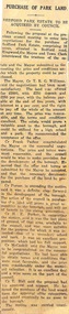
Newspaper, Bedford Park Estate to be Acquired by Council - Purchase of park land - undated and unsourced
... Following the proposal at the previous council meeting to enter into negotiations for the purchase of Bedford Park Estate, comprising 26 acres, situated in Bedford Rd., Ringwood, the Mayor and the Town Clerk interviewed the trustees of the estate and the Mayor submitted to the meeting the price and conditions under which the property could be purchased. ...Following the proposal at the previous council meeting to enter into negotiations for the purchase of Bedford Park Estate, comprising 26 acres, situated in Bedford Rd., Ringwood, the Mayor and the Town Clerk interviewed the trustees of the estate and the Mayor submitted to the meeting the price and conditions under which the property could be purchased. ...ClippingFollowing the proposal at the previous council meeting to enter into negotiations for the purchase of Bedford Park Estate, comprising 26 acres, situated in Bedford Rd., Ringwood, the Mayor and the Town Clerk interviewed the trustees of the estate and the Mayor submitted to the meeting the price and conditions under which the property could be purchased. The Mayor, Cr. T. R. G. Williams, said the negotiations had been most satisfactory. The land was offered for £2,000, with £250 deposit and £250 per year, with the balance payable at the end of five years. The estate would prove a valuable asset to the borough, and could be used for a high school and a park. -
 Ringwood and District Historical Society
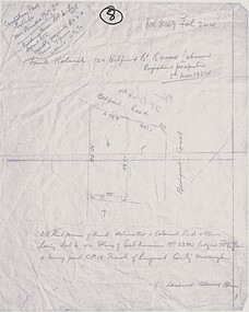
Map, Plan of Subdivision - Canterbury Park Estate, Ringwood East, Victoria - 1954
... Canterbury Park Estate T.M. Burke Pty Ltd. Purchase price lot 6 £525 Deposit £55. ...Canterbury Park Estate T.M. Burke Pty Ltd. Purchase price lot 6 £525 Deposit £55. ...Hand drawn page with diagram of map and property title information - three residential allotments on Bedford Road and Bedford Court, Ringwood East.Vol 8069 Fol 204. Canterbury Park Estate T.M. Burke Pty Ltd. Purchase price lot 6 £525 Deposit £55. Monthly payments £11. Terms 7 years, Interest 4-1/2%. Frank Kolarch 124 Bedford Road Ringwood, Labourer, Registered proprietor 5th November 1954. Lot 6 Plan of Subdivision no. 23805. Part of CP18, Parish of Ringwood, County of Mornington. -
Eltham District Historical Society Inc
Document - Folder, Spence, Maxwell
... Park...Orrs Dam...Pecks Dam...Wal Scriver...Montmorency Tennis Club...Albert Price...Maxwell Spence Briar Hill Montmorency Fernside Avenue Briar Hill Montmorency State School Were Street Montmorency Briar Hill State School Stan Stainsby Hee Alcock Ned Haughton Australian Paper Mills Lovitool Tomasetti baker of Greensborough Gladstone Avenue Briar Hill Beaconsfield Road Briar Hill Williams Road Briar Hill Ellis family Hillcrest playfield field Ben Barnett Bill Slater Colin Pugh Clifton Pugh St Helena Karingal Drive St Helena Ted Walker Weidligh Roslind Miller Graham Kennedy Jimmy Beale Leach Street St Helena Plenty River St Faith's Chrch of England Briar Hil St Andrew's Church Briar Hill St Francis Xavier Catholic Church Briar Hill Herbie Wilson Victoria Coffee Palace Eltham Higher Elementary School Kate McKenie Diamond Creek Frank Phillips Wingrove Park Bremner's Park Orrs Dam Pecks Dam Wal Scriver Montmorency Tennis Club Albert Price Hill Fred Balaam Greensborough RSL Joe Poulter Fairfield RSL Youth Club Bristcoes Hardware Merchants Montmorency RSL Jack Shallard Ted Weiland Petrie Park South Riding Ratepaers and Tenants Association Dr Keith Alexander Fred Durham Eltham Shire Council Meruka Park Max Watson Eric Harmer Spence Park Montmorency Mountain View Railway Bridge Montmrency Pre School Lower Plenty Fire Brigade Eltham High School Newspaper clippings, A4 photocopies, etc Spence, Maxwell Document Folder ...Max Spence came to Briar Hill as a child in 1923, and lived in the area for many years. Contents Typed and manuscript notes (2pp missing from MS), undated but ?c1990. "Spence: My Briar Hill and Montmorency." Reminiscences of Maxwell Spence of Briar Hill and Montmorency from 1923. Manuscript notes, AGM 1991, "Max Spence". Newspaper clippings, A4 photocopies, etcmaxwell spence, briar hill, montmorency, fernside avenue briar hill, montmorency state school, were street montmorency, briar hill state school, stan stainsby, hee alcock, ned haughton, australian paper mills, lovitool, tomasetti baker of greensborough, gladstone avenue briar hill, beaconsfield road briar hill, williams road briar hill, ellis family, hillcrest playfield field, ben barnett, bill slater, colin pugh, clifton pugh, st helena, karingal drive st helena, ted walker, weidligh, roslind miller, graham kennedy, jimmy beale, leach street st helena, plenty river, st faith's chrch of england briar hil, st andrew's church briar hill, st francis xavier catholic church briar hill, herbie wilson, victoria coffee palace, eltham higher elementary school, kate mckenie, diamond creek, frank phillips, wingrove park, bremner's park, orrs dam, pecks dam, wal scriver, montmorency tennis club, albert price hill, fred balaam, greensborough rsl, joe poulter, fairfield rsl youth club, bristcoes hardware merchants, montmorency rsl, jack shallard, ted weiland, petrie park, south riding ratepaers and tenants association, dr keith alexander, fred durham, eltham shire council, meruka park, max watson, eric harmer, spence park montmorency, mountain view railway bridge, montmrency pre school, lower plenty fire brigade, eltham high school -
Eltham District Historical Society Inc
Document - Folder, Squire family
... Price...Andrew Griffith...Irvine Hewitt...Honorary Justices Association...Eltham Court...William Brinkotter...Were Street Montmorency...Sherbourne Road...Eltham Police Station...Eltham District Play Centre Montmorency branch...Montmorency park...Frederick Vincent Squire Hazel Squire Lorraine Squire Briar Hill Primary School Eltham Shire Councill Sir Dallas Brooks Eltham Country Womens Association Dean Lacey Eltham Community Festival Edward Hughes Hazel Rose Squire nee Hughes Deirdre Squire James Squire Genista House Greensborough Avery sisters Diamond Valley Community Hospital Briar Hill Hardware 25-31 Sherbourne Road Briar Hill Eltham Cottage Hospital Eltham Methodist Hall Dr Edward Cordner Dr Bradbury Dr Sinclair Albert Charles Henry Price Andrew Griffith Irvine Hewitt Honorary Justices Association Eltham Court William Brinkotter Were Street Montmorency Sherbourne Road Eltham Police Station Eltham District Play Centre Montmorency branch Montmorency park Lower Plenty park Fitzsimmons Lane bridge Kangaroo Ground Max McMahon Martin McMahon Clive Tingate Eltham Clay Bird Shooting Club Greensborough Masonic Lodge Mountain View Road Briar Hill Briar Hill Hall H R Squire Family Reserve Hazel Rose Court Montmorency Briar Hill Swimming Pool Centre Briar Hill Timber and Hardware Stan Nedwell Montmorency Football Club Sylvia Davey Briar Hill Girl Guide Group Montmorency Girl Guides Eltham Pony Club Rederick Nedwell Robert Manuell Sutherland Homes Committee Red Cross Eltham Rurl Group Lower Plenty Neighbourhood House Eltham/Diamond Valley Citizens AdviceBureau Cape Otway ratio-operated lighthouse Heidelberg Town Hall Ouyen High School J B Were St Helena Briar Hill Timber and Trading Pty Ltd St Margaret's Church Eltham D V Darwin A W Brinkkotter D C O'Beirne Newspaper clippings, A4 photocopies, etc Squire family Document Folder ...Frederick Vincent Squire established a building business in Briar Hill, later becoming an Eltham Shire Councillor and responsible for many local advances; he was later Shire President. He and wife Hazel with involved with numerous community activities. Their children continued local involvement. Contents Letter Shire Secretary to F V Squite, 2 October 1981. Items of Council business of interest to F V Squire. Letter F V Squire to Shire Seretary, 3 October 1963. Accepting and declining social invitation. Newspaper article: "Wife of former councillor dies", Diamond Valley News, 7 October 1986. Death of Hazel Squire. Another article: "Young Eltham man recovering after horse-riding accident". Diamond Valley News, 7 October 1986. Dean Lacey seriously injured in horse riding accident. Another article: "Everyone loves a community parade.". Diamond Valley News, 7 October 1986. Eltham Community festival will be held again. Typed notes, no author:"Squire Family History", 18 December 1989. Newspaper article: "Briar Hill building recalls early days", Diamond Valley News, 12 November 1991. Biography of Fred Squite. Handwritten note, 30 January 1998: Names and telephone numbers.Newspaper clippings, A4 photocopies, etcfrederick vincent squire, hazel squire, lorraine squire, briar hill primary school, eltham shire councill, sir dallas brooks, eltham country womens association, dean lacey, eltham community festival, edward hughes, hazel rose squire nee hughes, deirdre squire, james squire, genista house greensborough, avery sisters, diamond valley community hospital, briar hill hardware, 25-31 sherbourne road briar hill, eltham cottage hospital, eltham methodist hall, dr edward cordner, dr bradbury, dr sinclair, albert charles henry price, andrew griffith, irvine hewitt, honorary justices association, eltham court, william brinkotter, were street montmorency, sherbourne road, eltham police station, eltham district play centre montmorency branch, montmorency park, lower plenty park, fitzsimmons lane bridge, kangaroo ground, max mcmahon, martin mcmahon, clive tingate, eltham clay bird shooting club, greensborough masonic lodge, mountain view road briar hill, briar hill hall, h r squire family reserve, hazel rose court montmorency, briar hill swimming pool centre, briar hill timber and hardware, stan nedwell, montmorency football club, sylvia davey, briar hill girl guide group, montmorency girl guides, eltham pony club, rederick nedwell, robert manuell, sutherland homes committee, red cross, eltham rurl group, lower plenty neighbourhood house, eltham/diamond valley citizens advicebureau, cape otway ratio-operated lighthouse, heidelberg town hall, ouyen high school, j b were, st helena, briar hill timber and trading pty ltd, st margaret's church eltham, d v darwin, a w brinkkotter, d c o'beirne -
 Eltham District Historical Society Inc
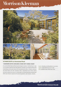
Document - Property Binder, 16 Homestead Road, Eltham, 'Handfield House'
... Esta Handfield died in 1995 The property was sold in 1996 Property history (source realestate.com.au) 2022 – Sold $2,240,000 September 17, 2022 by Jellis Craig - Eltham 1998 – Sold $348,500 June 20, 1998 1996 – Sold $250,000 September 9, 1996 (possibly Stockdale & Leggo) The property was offered for sale in 2008 by Morrison Kleeman with a price guide of $900,00 to $990,00 but it has not been confirmed if this sale proceeded Property Eltham houses John Handfield Esta Handfield Robin Boyd 16 Homestead Road Handfield House 45 Lavender Park Road Miscellaneous clippings, notes, photocopies, etc held on the subject property. 16 Homestead Road, Eltham, 'Handfield House' Document Property Binder ...Contents: 1. Morrison Kleeman Sales brochure 2008 2. Newsclipping; Advertisement, Morrison Kleeman, Eltham South 16 Homestead Road, Diamond Valley Leader, November 5, 2008, p7 (on reverse, p8 Advertisement, Morrison Kleeman, Eltham 45 Lavender Park Road) Designed by Robin Boyd for friends John and Esta Handfield, Handfield House was built 1961. In a letter dated 16 May 1989 to Blanche Shallard of the Shire of Eltham Historical Society, John Handfield advised that the house was designed by their friend Robin Boyd and that it was built in 1961. As of that date they had been the only occupants. They were still the owners when the house was included in the 1992 Shire of Eltham Heritage Study The 1992 Study advised: CULTURAL SIGNIFICANCE Designed by well-known Victorian Architect Robin Boyd after he returned from lecturing architectural students in Japan, the Handfield residence shows the influence of traditional Japanese design in its modular wall arrangements, solid and glazed panels and sliding exterior doors. The courtyard planning, floor to ceiling glass walls and the combination of single and double storey sections on the steep site illustrate quite advanced dwelling design for its time. Designed to house three generations, grandparents, their children and grandchildren, the house at the time of the 1992 study was reported to be very intact. DESCRIPTION Quite advanced design, in planning and detailing. Plan U-shaped. Single and double storied; the arms of the U are basically single storied, while the base running parallel with the Yarra River is two storied. Walls timber stud framed?, asbestos cement sheet clad. Roofs flat?. Floors timber, some concrete?. Features include the modular wall design, courtyard planning, combination of single and double storey sections, internal planning and floor to ceiling glass walls. SOURCES OF INFORMATION: Information from Mr. John Handfield. CONSERVATION GUIDELINES: Keep this residence intact. Esta Handfield died in 1995 The property was sold in 1996 Property history (source realestate.com.au) 2022 – Sold $2,240,000 September 17, 2022 by Jellis Craig - Eltham 1998 – Sold $348,500 June 20, 1998 1996 – Sold $250,000 September 9, 1996 (possibly Stockdale & Leggo) The property was offered for sale in 2008 by Morrison Kleeman with a price guide of $900,00 to $990,00 but it has not been confirmed if this sale proceeded property, eltham, houses, john handfield, esta handfield, robin boyd, 16 homestead road, handfield house, 45 lavender park road -
 Eltham District Historical Society Inc
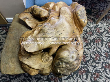
Photograph - Digital Photograph, Jim Connor, Sculpture; 'Platy' created by Peter Carrigy (c.1992), Eltham Library, 4 April 2024
... Park around 1992. He was moved by its beauty and creativity and felt then it should be where it could be explored by little hands but could not afford the asking price of $2,300. ...Park around 1992. He was moved by its beauty and creativity and felt then it should be where it could be explored by little hands but could not afford the asking price of $2,300. ...Platy is a wonderfully tactile platypus sculpture sensitively carved from the root of a Bunya Pine, by the highly awarded, collected wood artist, Peter Carrigy. The sculpture of Platy was a gift from the councillors of the then Shire of Eltham in 1994 to the children’s section of the new library, with the intention that it be placed where it could be touched, explored and experienced by children of current and future generations. Peter Carrigy travelled from his home in South Australia to attend the library opening of Eltham Library on Sunday, 22nd May 1994. Peter Carrigy’s delightful platypus sculpture (known as Platy), carved from the root of a Bunya Pine, has been lovingly appreciated since the opening of the Eltham Library in 1994, by many young (and older) visitors to the children’s section of this wonderful award-winning library, designed by Greg Burgess and associates. Jim Connor first saw the sculpture on display at the Wiregrass Gallery, opposite Eltham Lower Park around 1992. He was moved by its beauty and creativity and felt then it should be where it could be explored by little hands but could not afford the asking price of $2,300. Luckily, it was still available in 1994 when then Cr. Jim Connor approached all councillors about using some of their ward funds to purchase, then donate it as a gift for the children’s area, at the opening of the library. Cr. Connor negotiated with Leigh Carbines, who operated the gallery and he and Peter Carrigy, the sculptor, moved on price seeing where it was going to go. Cr. Connor arranged to purchase it for $1,500, being $500 from each of three wards, then Leigh organised the stand and mount for it. In the leadup to the 30th Anniversary celebrations of Eltham Library, Jim Connor (now president of Eltham District Historical Society) approached artist Peter Carrigy with the support of the Arts officers at Nillumbik Shire Council. They were interested to learn more about any method and technique that could be used for restoration. It was felt such information would be of great value to a short-and long-term conservation program, to ensure Platy is preserved for future generations to enjoy.dr andrew lemon, eltham library, irene gerard, jim connor, jim connor collection, peter carrigy, platy, sculpture -
 Glen Eira Historical Society
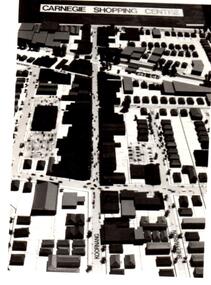
Article - Koornang Road, Carnegie
... The article provides a brief description of the area, house prices and includes a colour photograph of the Koornang Road Carnegie shopping strip. 2/The file also includes an undated original black and white aerial photograph (84mm x 64mm) of the Carnegie Shopping Centre. Source unknown. Carnegie Koornang Road Packer Park ...File contains 2 items about Carnegie shopping centre in Koornang Road. 1/A one page article from The Age newspaper, dated 05/11/2011, about Carnegie and its shopping centre along Koornang Road. The article provides a brief description of the area, house prices and includes a colour photograph of the Koornang Road Carnegie shopping strip. 2/The file also includes an undated original black and white aerial photograph (84mm x 64mm) of the Carnegie Shopping Centre. Source unknown.carnegie, koornang road, packer park, lord reserve, shepparson avenue, suburbs, shopping centres -
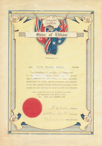 Eltham District Historical Society Inc
Certificate, Shire of Eltham: Presented to Pte. George Melville Balfour, VX6104, 1 August 1942
... Price, Eltham, George Melville Balfour, Lavender Park, Prisoner of War, Second Word War, shire of eltham, VX6104...Park, Eltham. He served in the 2/8 Batallion, AIF, in North Africa and taken prisoner of war in Greece. In the UK post May 1945 and in Australia December 1949. Never married. 2/8 Battallion, AIF, Certiificate, Cr. A. Brinkkotter, Cr. Price ...Certificate of appreciation presented to Private George Melville Balfour, VX6104, for voluntary enlistment for active service overseas. Prior to the war, George Balfour lived at Wangakeirra(?), Kangaroo Ground. Post war, he lived at Lavender Park, Eltham. He served in the 2/8 Batallion, AIF, in North Africa and taken prisoner of war in Greece. In the UK post May 1945 and in Australia December 1949. Never married.Colour photocopy 33 x 24 cm of a certificate 2/8 battallion, aif, certiificate, cr. a. brinkkotter, cr. price, eltham, george melville balfour, lavender park, prisoner of war, second word war, shire of eltham, vx6104 -
 Eltham District Historical Society Inc
Film - Video (VHS), Jenni Mitchell, Demolition of the Shire of Eltham Offices, 1996
... park for Shire Offices. Cuts to a group of people standing in access to visitor carpark with new Eltham Library in background, one being immediate former Shire of Eltham President, John Graves. Scenes of people looking through chain link fence and security guard checking front door. John Graves being filmed that someone informed him the Shire was offering the building to the Community Health Centre for $2.3 million and that if they had been offered a price...park for Shire Offices. Cuts to a group of people standing in access to visitor carpark with new Eltham Library in background, one being immediate former Shire of Eltham President, John Graves. Scenes of people looking through chain link fence and security guard checking front door. John Graves being filmed that someone informed him the Shire was offering the building to the Community Health Centre for $2.3 million and that if they had been offered a price ...Poor video quality (noise and interference), incomplete and unedited raw footage. A video documenting the demolition of the Shire of Eltham offices at 895 Main Road Eltham under the direction of the Commissioners appointed for the new Shire of Nillumbik and some of the communities activities surrounding the event. The building was demolished exactly 25 years after the southern wing housing Engineering and Planning on the upper level and the Eltham Library on the ground level was opened in celebration of the Shire of Eltham's centenary. Video has lots of distortion and noise, and sections of clips dubbed over. Immediate initial footage of Jenni Mitchell talking about asbestos claims in the Shire Offices (Sigmund Jorgensen standing behind her) advising Council did a review of the building several years previously and had been cleared of health problems. Cuts to group of people standing outside front door of offices but possibly voice dub over not related ? Then the date 27 Jul 1996 on a scene flashes on screen immediately followed by an edited clip intro of title and credits with classical music track. It then opens with Jenni Mitchell driving to the Shire Offices on Saturday 27 July 1996 at 11.00am. Footage of Main Road past Pitt Street, Alistair Knox Park then entering Shire Office driveway which is fenced off and contractor signs hanging up. Scenes at rear of building showing some internal demolition has commenced. View of the Administration wing. More clips of road driving, Alistair Knox Park, Eltham Library and visitor car park for Shire Offices. Cuts to a group of people standing in access to visitor carpark with new Eltham Library in background, one being immediate former Shire of Eltham President, John Graves. Scenes of people looking through chain link fence and security guard checking front door. John Graves being filmed that someone informed him the Shire was offering the building to the Community Health Centre for $2.3 million and that if they had been offered a price of $1.1 for what it apparently was sold for they would have snapped it up. View of truck loaded with brick rubble literally struggling to ascend the hill of Library Place to exit into Main Road. Cuts to a scene looking at Eltham War memorial Hall through the Memorial Gate, then the Shillinglaw trees and large banner sign ‘Delta Demolitions’ hanging on office façade. Views of front door, old library and bluestone wall. Scene (31 Jul 1996) filmed at night of several white crosses with “RIP Community” and “RIP Democracy”. Scene (1 August 1996) again driving along Main Road towards the Shire Offices then scenes of the offices showing substantially more demolition to exterior, groups of people standing on footpath outside watching, Delta heavy demolition machines, woman holding sign “Democracy where have you gone …”, the odd person in full protection gear and breathing apparatus hand carrying materials out to place on rubbish pile in front of people standing on footpath watching (with no protection) and then stamping on it to break it creating dust, security person in hard hat (no other protection) wandering around, many groups standing around watching, news film crew, person standing on roadside edge holding signs facing traffic stating “Pirate Planning” and “ Grant us your ears” also sign on back of parked car “Elthams High Jacks”, another sign “Community Democracy”, views of crosses in Main Road median strip “RIP Community”, groups of people on footpaths and reporters conducting interviews, footage of unknown person standing with Jenni Mitchell and Sigmund Jorgensen advising people have the right to protest, Jenni Mitchell urging people to ask questions of local MP and Council and Sigmund Jorgensen referring to the three historic Shillinglaw trees with demolition machinery operating in background, Jenni Mitchell and others installing more crosses in median strip; demolition machines operating inside and outside the building, more views of onlookers including Sigmund Jorgensen then Police approaching on footpath, workers and machinery continuing to operate, views of the old library being demolished, the former Community Services department, security personnel. Scene (2 August 1996) more heavy demolition machinery in operation smashing building up, people standing around southern wing watching, view overlooking Eltham Library of train pulling in to Eltham station. Scene (7 August 1996) more heavy demolition and people wandering around with only hard hat protection, no dust protection, comments from one operator dumping a bin of material stating “wait till there’s a Hungry Jack’s here, you’ll be laughing, fuel, videos, hamburgers. You’ll be up with the rest of the world soon, you’ll have electricity and everything here, ha ha ha ha”, more heavy machinery demolition and breaking up of materials, view of Hitachi train going by and Administration wing, view inside the front door opening of the staircase leading to upper level, person walking around operating heavy machinery with a hose spraying rubble (no protective gear other than hard hat interspersed with edit cuts of meeting of Commissioners and independent observers on panel as well as members of the community in public gallery. Nillumbik Shire CEO Barry Rochford addressing the meeting., Chief Commissioner Don Cordell directly addressing Jenni Mitchell with respect to permission to take photographs, Barry Rochford continues to address the question asked of Council about the valuation of the former Shire of Eltham Office building/site, public gallery calling out asking why was building demolished, what was the urgency. Scene (14 August 1996) views of southern wing, previous single demolition operator again mocking people filming, operators working in and around building, Shillinglaw trees and largely demolished front, heavy demolition equipment at work, piles of building rubble, hose spraying water over rubble, large trucks arriving for rubble removal and loading of truck. Scene (21 August) more of the same, building virtually down, Shillinglaw trees standing tall and alone, water spraying on rubble and wattle in bloom. Cuts to Council meeting with public onlookers. Barry Rochford walks out, Wayne Phillips addresses meeting explaining one or two people shouting, members of the community challenging Council (Commissioners) about why due process appear to have been subverted. Former Shire President Robert Marshall in public audience, cuts back to Shire office carpark entrance site and sign hung on fence in front of library “Think Again!” and people standing around observing awaiting a protest demonstration erecting a large sign on stilts stating “Shell No!”, people singing a revised version of God Save the Queen (God Save Us All), Sigmund Jorgensen in attendance, Jenni Mitchell, Sigmund Jorgenson and others address the protest crowd, followed by people mingling, music being played then people standing around the cleared site circumference all with arms linked (video very broken up with noise) then chants “Save the Gateway” and “No Shell for Eltham” and more music and singing “Put up a parking lot”. The crowd then proceeds to walk along the footpath of Main Road. Scene (15 Sep 1996) meeting at Montsalvat in Great Hall addressed by Sigmund Jorgensen discussing a recently published list of the Commissioner’s to senior Council Officers of banned Nillumbik people, others encouraging people to view proposed plans for the site and lodge objections. Specific issues regarding asbestos claims are also addressed. Harry Gilham addresses the meeting on the subject of the Eltham War Memorial and Memorial Gardens and how Council believe a roundabout in the vicinity is of greater importance. Views of various artworks on display (for auction) and music performance in the Barn Gallery. Meeting addressed by Sigmund Jorgensen discussing an appeal against Council granting a permit to Dallas Howgate to develop the site and that the Minister has called the matter in to be decided by the governing council. This is followed by an auction of paintings. 0.05 - Jenni Mitchel, Sigmund Jorgensen and Peter Doughtery in background. 0.18 - Jock Kyme in front of building – David Essex, Marg Johnson on his left-hand side. 5.34 - John Graves – ex Shire of Eltham Councillor and President. 9.02 - Unknown person being interviewed. 9.30 - Jenni Mitchell, unknown person, Mark Burns, community activist. 10.04 - Sigmund Jorgenson, Jenni Mitchell. 12.04 - Police members 21.33 - Nillumbik Council offices 7 August 1996 Barry Rochford CEO, Vin Heffernan Commissioner, Don Cordell Chief Commissioner, Kevin Abbott Commissioner, unknown person. 28.00 - Barry Rochford CEO 28.05 - Kahn Frankie - in commissioner’s seat after commissioners and council staff have vacated the council chamber. 28.26 - Wayne Phillips, State Liberal member for Eltham, addressing community in response to questions. 28.36 - Mark Burns, community activist addressing gallery. 28.48 - Ken Hines, ex Shire of Eltham Councillor and President. 29.34 - Ken Hines, ex Shire of Eltham Councillor and President standing, Robert Marshall, ex Shire of Eltham Councillor and President seated in front. 29.41 - Karen Gerhards, community activist. 30.06 - Marg Johnson with loud hailer, next to Jock Kyme, community activist. 31.32 - Marg Johnson with possibly Frank Burgoyne?, Sigmund Jorgensen, Jock Kyme. 35.35 - Harry Gilham at meeting at Montsalvat on 15 September 1996. 35.43 - Sigmund Jorgenson at lectern. 36.42 - Marg Jennings. 37.47 - Mark McDonald, Jim Connor, ex Shire of Eltham Councillor in background. 36.28 - John Cohen, ex Shire of Eltham Councillor and President. 38.56 - Ken Hines, ex Shire of Eltham Councillor and President. 41.11 - Harry Gilham, president of the Eltham District Historical Society. 43.55 - Sigmund Jorgensen in Long Gallery at Montsalvat, at start of the art auction to raise funds for community action. 45.50 - Unknown person conducting art auction. VHS Video cassette (poor quality) Converted to MP4 file format 45:01, 535MBvideo recording, 895 main road, alistair knox park, artworks, auction, barn gallery, barry rochford, community health centre, dallas howgate, delta demolitions, demolition, don cordell, eltham, eltham library, eltham shire office, eltham war memorial, eltham war memorial gate, eltham war memorial hall, great hall, harry gilham, jenni mitchell, john graves, library place, main road, memorial gardens, mervyn hannan, montsalvat, pitt street, protest, robert marshall, roundabout, shell oil, shillinglaw trees, sigmund jorgensen, sign, wayne phillips
