Showing 26709 items matching " road districts"
-
 Bacchus Marsh & District Historical Society
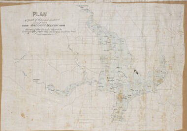
Map, Plan of part of the road district of Bacchus Marsh circa 1856-1862
... Plan of part of the road district of Bacchus Marsh circa 1856-1862......Road Districts...By 1856 the local committee in Bacchus Marsh was constituted as the Bacchus Marsh Road District. This entity continued until 1862 when the name changed to the Bacchus Marsh and Maddingley Road District. ...A single page paper map showing a plan of part of the road district of Bacchus Marsh. The map is pasted into a bound volume containing 76 maps or plans in total. ...Bacchus Marsh Victoria Maps Bacchus Marsh Road District Local government Road Districts Irrigation A single page paper map showing a plan of part of the road district of Bacchus Marsh. ...Local government in much of Victoria including the Bacchus Marsh area began with the formation of 'local committees'. These local committees could make representations to a Central Road Board regarding plans for road construction. Road construction and maintenance were seen as the essential tasks of these early local government authorities. By 1856 the local committee in Bacchus Marsh was constituted as the Bacchus Marsh Road District. This entity continued until 1862 when the name changed to the Bacchus Marsh and Maddingley Road District. This new entity lasted until 1871 when the local government authority in accordance with new statewide legislation became known as the Shire of Bacchus Marsh. The title of this plan being a plan of 'a portion of the road district of Bacchus Marsh' suggests that the plan was produced sometime between 1856 and 1862. The main purpose of this map was to shown the irrigable land in the district and the sources from which water for irrigation could be drawn. Bacchus Marsh was an early irrigation district in Victoria. Irrigation trusts were formed in the 1880s and 1890s to manage irrigation districts. But this was the culmination of many years of earlier attempts to construct irrigation systems in the Bacchus Marsh area and create a system to manage irrigation more broadly. This map dating from around 1856-1862 is an important cartographic document which provides evidence of how the early planning for irrigation was developing in the Bacchus Marsh region.A single page paper map showing a plan of part of the road district of Bacchus Marsh. The map is pasted into a bound volume containing 76 maps or plans in total. High resolution digital image stored on BMDHS computer network. bacchus marsh victoria maps, bacchus marsh road district, local government, road districts, irrigation -
 Glen Eira Historical Society
Book - Local Government Act First Report of the Assistant Commissioner of Roads and Bridges
... ... Road Districts...The report also gives some information about the Shire of Caulfield, which contained 24 road districts and 340 rate payers in 8¼ square miles, and the Shire of Moorabbin, which contained 62 road districts and 713 rate payers in 30 square miles....F. the Honourable Caulfield Moorabbin Road Districts Point Nepean Road Nepean Highway Dandenong Road Princes Highway Brown Edwin Osher Joseph Cosgrove John Ferres John Roads and Bridges Offices Caulfield Roads District Moorabbin Roads District Road Construction and Maintenance Roads and Streets Acts of Parliament Book Local Government Act First Report of the Assistant Commissioner of Roads and Bridges ...This file contains 1 item: 1/The Local Government Act, First Report of the Assistant Commissioner of Roads and Bridges, printed by order of the Victorian Legislative Assembly on 08/03/1865. The document is the first annual report of John Steavenson, Assistant Commissioner of Roads and Bridges under s330 of the Local Government Act no. 176 (1863), and relates to transactions which took place from 02/09/1863 to 31/12/1864. The report outlines operations carried out by the Department of Roads and Bridges in this period. In the Glen Eira area this includes: separating electoral subdivisions of single districts (Moorabbin), adding detached portions of territory to road districts and shires (Caulfield), appointing of and altering in polling places, appointing of polling places for ridings of shires and subdivisions of road districts (Moorabbin), preparing and transmitting of forms of books also of pro forma accounts for guidance of local bodies in keeping their accounts, appointment of main roads, construction of a main road, ‘Dandenong’, in the Caulfield and Gardiner districts, proclaiming of Common Toll Roads, names of and security given by Managers of Common Toll Roads. The report also gives some information about the Shire of Caulfield, which contained 24 road districts and 340 rate payers in 8¼ square miles, and the Shire of Moorabbin, which contained 62 road districts and 713 rate payers in 30 square miles.local government act, assistant commissioner of roads and bridges, legislative council, caulfield historical soceity, steavenson john, sullivan j. f. the honourable, caulfield, moorabbin, road districts, point nepean road, nepean highway, dandenong road, princes highway, brown edwin, osher joseph, cosgrove john, ferres john, roads and bridges offices, caulfield roads district, moorabbin roads district, road construction and maintenance, roads and streets, acts of parliament -
Glen Eira Historical Society
Plan - Nettalie
... ... Caulfield Road District...An A4 photocopy of the 'Plan of the Caulfield Road District' dated 1867. This plan shows the location of the properties owned by A Shaw and Blundell on Balaclava and Orrong Roads where Nettalie is situated. ...Glen Eira Historical Society 965 Glen Huntly Rd Caulfield VIC 3162 melbourne An A4 photocopy of the 'Plan of the Caulfield Road District' dated 1867. This plan shows the location of the properties owned by A Shaw and Blundell on Balaclava and Orrong Roads where Nettalie is situated. ...An A4 photocopy of the 'Plan of the Caulfield Road District' dated 1867. This plan shows the location of the properties owned by A Shaw and Blundell on Balaclava and Orrong Roads where Nettalie is situated. The plan includes all the landowners listed where their property was, the street names and other landmarks of 1867 including railways, hotels and reserves.caulfield, caulfield north, elsternwick, st kilda east, parish of prahran, parish of moorabbin, caulfield road district, melbourne and brighton railway, rosstown railway, elsternwick railway station, caulfield railway station, rosstown railway station, murrumbeena railway station, baptist church, paddy’s swamp reserve, cemetery reserve, leman swamp reserve, caulfield racecourse reserve, brighton cemetery, the vine caulfield hotel, the tam o’shanter hotel, melbourne hunt hotel, royal hotel, hotham street, horne street, nepean highway, north road, orrong road, dandenong road, princes highway, kooyong road, alma road, inkerman road, balaclava road, glen eira road, glen huntly road, hawthorn road, cemetery road, bambra road, redan road, kambrook road, neerim road, booran road, racecourse road, grange road, koornang road, murrumbeena road, crosbie road, kangaroo road, poath road, ford w, lempriere, cople j, riddell j c, manifold j, testar t, billing r h, semple, blundell, shaw a, butchart g, stephen j w, stephen g sir, hart j, duncan g, blackie r, stephen f, mccombie t, woollaston h, higgins j, lloyd j c, daish j, mcleod j, hughes d, wilson a, jamieson g, webb g h, renwick s, pennington h, dunn j, kirkpatrick w, ricketson w, toad a, sayce j, watts t, widgery, store, guess j, anketell j, clack j, sissen w, clayton g, dickson d, bevan j, hart t, anderson j, hart mrs, webb h, masters s, waghorn j, hemming c, hiam c, farquhar w, newing t, payne t, cooper r, snipe s, chambers j, forster w, summers r, harriman b, warrick, o’connell, long j, peck r, cochrane c, murray ross w, evans c, kennedy j, maclean n, forster, lyall w, dean j, newton h, looker w, baker c, johnston, crosbie j, kerr, jones, parr, nelson c, montgomery l, parsons w, james j c, sibon c, smith sydney w, plans, maps, land subdivisions, land use, settlements, roads and streets, hotels, churches, police stations, post offices, land surveys, railway stations, railways, schoolhouses, commerce, clergy residences, official buildings, local government, road districts -
Whitehorse Historical Society Inc.
Document, Constituting a road district to b a shire, 1857, 1862, 1872
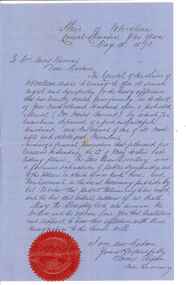
... Constituting a road district to b a shire.......Nunawading Road District...(v) Extract from Victorian Government Gazette, 7 Aug 1857 - Proclamation of Nunawading Road District (vi) Public meeting for election of members for Nunawading District Roads Board....(v) Extract from Victorian Government Gazette, 7 Aug 1857 - Proclamation of Nunawading Road District (vi) Public meeting for election of members for Nunawading District Roads Board....Constituting a road district to b a shire. Document Document ...Extract from Government Gazette(iv)Extract from Government Gazette No 25, 3 May 1872 - Proclamation of Shire of Nunawading. (v) Extract from Victorian Government Gazette, 7 Aug 1857 - Proclamation of Nunawading Road District (vi) Public meeting for election of members for Nunawading District Roads Board.Extract from Government Gazette local government, nunawading road district, shire of nunawading, barkly, henry sir -
Glen Eira Historical Society
Document - Watts, Thomas
... ... Road Districts...Local Government Road Districts Caulfield Roads District Caulfield Shire Council Shire President Watts James Salter Thomas Watts and Son Glen Eira Road Kooyong Road Edenthorpe Estate Watts Estate Watts Helen K Document Watts, Thomas ...This file contains various information on architect Thomas Watts who resided at GLENHUNTLY. It includes a photocopied entry on Watts contained in Sutherland VICTORIA AND ITS METROPOLIS, annotated hand-written entries from a rates book on ownership of GLENHUNTLY, and hand-written note of an entry in THE ARGUS dated 26th July 1913 about Watts, a pencilled card for Watts and a photocopy of an article on the property GLENHUNTLY in THE SOUTHERN CROSS newspaper, dated 18th June 1986 Photocopy of photograph, date and photographer unknown, of Thomas Watts and his daughter Kate Two page document describing the papers of Thomas Watts held at the State Library of Victoria. A brief list of documents held at the library is included.watts thomas architect, orrong road, house, glenhuntly st marys, glenhuntly road, rosstown sugar works, school, caulfield common school, justice of the peace, watts kate, armstrong (nee watts) mrs j.a., local government, road districts, caulfield roads district, caulfield shire council, shire president, watts james salter, thomas watts and son, glen eira road, kooyong road, edenthorpe estate, watts estate, watts helen k -
Whitehorse Historical Society Inc.
Document, Nunawading and District local government records
... ...Nunawading Road District...from Road District 1857 through to City of Nunawading 1994 and lists of location of records for each period within the Public Record Office. ...Records of the municipalities of Nunawading and Box Hill districts from Road District 1857 through to City of Nunawading 1994 and lists of location of records for each period within the Public Record Office. ...Local Government Nunawading Road District Shire of Nunawading Borough of Box Hill City of Box Hill Shire of Blackburn and Mitcham City of Nunawading Victoria. ...Records of the municipalities of Nunawading and Box Hill districtsRecords of the municipalities of Nunawading and Box Hill districts from Road District 1857 through to City of Nunawading 1994 and lists of location of records for each period within the Public Record Office. Extracts from PRO lists of holdings.Records of the municipalities of Nunawading and Box Hill districts local government, nunawading road district, shire of nunawading, borough of box hill, city of box hill, shire of blackburn and mitcham, city of nunawading, victoria. public record office -
 Sunshine and District Historical Society Incorporated
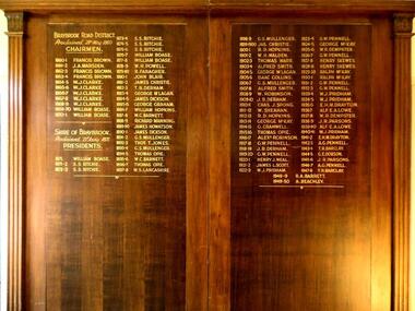
Honour Board - Braybrook Road District Honour Board Unveiling, Unveiled 15 March 1940
... Braybrook Road District Honour Board Unveiling...braybrook road district...Local government for the area began on 28th May 1860 when the BRAYBROOK ROAD BOARD DISTRICT was proclaimed, however this authority was soon superseded on 23rd January 1871 when the SHIRE OF BRAYBROOK came into existence. ...Contains in gold coloured lettering the names of people who served as CHAIRMEN of the BRAYBROOK ROAD DISTRICT and as PRESIDENTS of the SHIRE OF BRAYBROOK during the years 1860 to 1950....Braybrook Road District. Proclaimed 28th May 1860. Names: Francis Brown, J.A. ...Honour Board Braybrook Road District Honour Board Unveiling ...By around circa 1850 Braybrook was already well established, and during the gold rush period also became a staging point for prospectors on their way to the diggings. Local government for the area began on 28th May 1860 when the BRAYBROOK ROAD BOARD DISTRICT was proclaimed, however this authority was soon superseded on 23rd January 1871 when the SHIRE OF BRAYBROOK came into existence. The Shire of Braybrook continued as the local government authority for the district until the CITY OF SUNSHINE was proclaimed in 1951. This Honour Board was unveiled on Monday 18th March 1940 at 8:30 p.m., and was hung in the Council Chamber, at the Shire of Braybrook Hall, Sunshine.The Honour Board is a historical record of the people who served as heads of local government in the district from 1860 to 1950.Letter to special quests inviting them to the unveilingof the honour board on the 18th March 1940 at 8:30pm Photograph of large brown stained wooden structure comprised of two board sections positioned side by side to make one display board. Contains in gold coloured lettering the names of people who served as CHAIRMEN of the BRAYBROOK ROAD DISTRICT and as PRESIDENTS of the SHIRE OF BRAYBROOK during the years 1860 to 1950.Braybrook Road District. Proclaimed 28th May 1860. Names: Francis Brown, J.A. Marsden, W.J. Clarke, William Boase, S.S. Ritchie, W.H. Powell, R. Faragher, John Blair, James Christie, T.B. Derham, George Mclagan, James Dickson, George Graham, William Hopkins, W.C. Barnett, Richard Manning, James Howatson, G.S. Mullenger, Thomas Opie, W.S. Lancashire, R.D. Hopkins, W.H.Waldon, Thomas Warr, Alfred Smith, Isaac Collins, W. Robinson, J.B. Derham, Chas J. Spong, W. Sheahan, George McKay, G.Cranwell, Alexander Robinson, G.W. Pennell, Henry J. Neal, James L. Scott, W.J. Pridham, W.R. Dempster, Henry Skewes, Ralph McKay, E.M.H. Drayton, Alf E.A. Lowe, J.R. Parsons, A.G. Pennell, T.R. Barclay, G.E. Dobson, R.A. Barrett, A. Beachley.braybrook road district, shire of braybrook, chairmen, presidents -
 Sunshine and District Historical Society Incorporated
Honour Board - Braybrook Chairmen and Presidents Honour Boards, 1951
... ... Braybrook Road District...Two large honour boards of the Braybrook Road District Chairmen and Shire of Braybrook Presidents. ...Shire of Braybrook Braybrook Road District Honoue Board Names: Francis Brown, J.A. ...Erected in council offices to commemorate past civic leaders. Put up after the Shire of Braybrook was converted into the City of Sunshine in 1951. Removed after most of the City of Sunshine was absorbed into City of Brimbank on 15 December 1994. Salvaged by Sunshine & District Historical Society Inc.Two large honour boards of the Braybrook Road District Chairmen and Shire of Braybrook Presidents. Names and dates are in gold lettering.Names: Francis Brown, J.A. Marsden, W.J. Clarke, William Boase, S.S. Ritchie, W.H. Powell, R. Faragher, John Blair, James Christie, T.B. Derham, George Mclagan, James Dickson, George Graham, William Hopkins, W.C. Barnett, Richard Manning, James Howatson, G.S. Mullenger, Thomas Opie, W.S. Lancashire, R.D. Hopkins, W.H.Waldon, Thomas Warr, Alfred Smith, Isaac Collins, W. Robinson, J.B. Derham, Chas J. Spong, W. Sheahan, George McKay, G.Cranwell, Alexander Robinson, G.W. Pennell, Henry J. Neal, James L. Scott, W.J. Pridham, W.R. Dempster, Henry Skewes, Ralph McKay, E.M.H. Drayton, Alf E.A. Lowe, J.R. Parsons, A.G. Pennell, T.R. Barclay, G.E. Dobson, R.A. Barrett, A. Beachley.shire of braybrook, braybrook road district, honoue board -
Lakes Entrance Historical Society
Book, Bairnsdale Shire Council Centenary 1868, 1968
... A short history of the Shire of Bairnsdale Victoria from beginnings as a road district to the separation of the commercial centre as the Towns of Bairnsdale illustrated with photographs. ...Lakes Entrance Historical Society 4 Marine Parade Lakes Entrance gippsland Township Photography A short history of the Shire of Bairnsdale Victoria from beginnings as a road district to the separation of the commercial centre as the Towns of Bairnsdale illustrated with photographs. ...A short history of the Shire of Bairnsdale Victoria from beginnings as a road district to the separation of the commercial centre as the Towns of Bairnsdale illustrated with photographs. A list of Shire Presidents and officers is included.township, photography -
Canterbury History Group
Book, U.F.S Dispensary book
... Road... Canterbury and Districts United Friendly Societies Dispensary...Canterbury History Group 190A Canterbury Road Canterbury melbourne Canterbury Maling Road Canterbury and Districts United Friendly Societies Dispensary Wicks> C.W.B Friendly Societies Pharmacies Mr. ...Mr. C. W. B. Wick's prescription book for members of the Canterbury and District Friendly Societies Dispensary.canterbury, maling road, canterbury and districts united friendly societies dispensary, wicks> c.w.b, friendly societies, pharmacies -
 Ringwood and District Historical Society
Document, Extract from Government Gazette, 23/6/1871
... Page 998 of Gazette includes the following article: "Proposed attachment of part of the Shire of Berwick to the Upper Yarra Road district in the 'Parish of Ringwood'. Petition from Ratepayers."...Page 998 of Gazette includes the following article: "Proposed attachment of part of the Shire of Berwick to the Upper Yarra Road district in the 'Parish of Ringwood'. Petition from Ratepayers." ...Copy of printed documentPage 998 of Gazette includes the following article: "Proposed attachment of part of the Shire of Berwick to the Upper Yarra Road district in the 'Parish of Ringwood'. Petition from Ratepayers." -
Ringwood and District Historical Society
Envelope, Packet: Government Gazette photostats incl Toll charges 1864, Ringwood Cemetery 1871, Berwick items
... Government Gazette photostats (10 pages); Toll charges 1864; Berwick Road District 1862; Berwick Shire 1864; Berwick Shire added to 1871; Ringwood Cemetery 1871; Lillydale Shire 1872...Ringwood and District Historical Society 125A Warrandyte Road Ringwood North melbourne Government Gazette photostats (10 pages); Toll charges 1864; Berwick Road District 1862; Berwick Shire 1864; Berwick Shire added to 1871; Ringwood Cemetery 1871; Lillydale Shire 1872 Packet: Government Gazette photostats incl Toll charges 1864, Ringwood Cemetery 1871, Berwick items. ...Government Gazette photostats (10 pages); Toll charges 1864; Berwick Road District 1862; Berwick Shire 1864; Berwick Shire added to 1871; Ringwood Cemetery 1871; Lillydale Shire 1872 -
 Sunshine and District Historical Society Incorporated
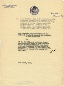
Document - Shire of Braybrook Invitation 1940 Unveiling of an honour board containing the names of Chairmen of Braybrook District Road Board and past presidents of the Shire, 1940
... Shire of Braybrook Invitation 1940 Unveiling of an honour board containing the names of Chairmen of Braybrook District Road Board and past presidents of the Shire...Shire of Braybrook Invitation 1940 Unveiling of an honour board containing the names of Chairmen of Braybrook District Road Board and past presidents of the Shire...Typed document inviting exShire of Braybrook presidents to the unveiling of an honour board containing the names of Chairmen of Braybrook District Road Board and past presidents of the Shire The document is dated 15th March 1940...Shire of Braybrook President Chairman Typed document inviting exShire of Braybrook presidents to the unveiling of an honour board containing the names of Chairmen of Braybrook District Road Board and past presidents of the Shire The document is dated 15th March 1940 Shire of Braybrook Invitation 1940 Unveiling of an honour board containing the names of Chairmen of Braybrook District Road Board and past presidents of the Shire Document Shire of Braybrook Invitation 1940 Unveiling of an honour board containing the names of Chairmen of Braybrook District Road Board and past presidents of the Shire ...Typed document inviting exShire of Braybrook presidents to the unveiling of an honour board containing the names of Chairmen of Braybrook District Road Board and past presidents of the Shire The document is dated 15th March 1940shire of braybrook, president, chairman -
Whitehorse Historical Society Inc.
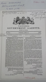
Document, Nunawading Road District, 1857
... Nunawading Road District......Nunawading Road District...A copy from Ivan Southall's 'A Tale of Box Hill', proclamation by Sir Henry Barkly, Governor of the Colony of Victoria, the name of Nunawading Road District. 6 Aug 1857. Extract from Victoria Government Gazette no 91....Nunawading Road District Document Document ...A copy from Ivan Southall's 'A Tale of Box Hill', proclamation by Sir Henry Barkly, Governor of the Colony of Victoria, the name of Nunawading Road District. 6 Aug 1857.A copy from Ivan Southall's 'A Tale of Box Hill', proclamation by Sir Henry Barkly, Governor of the Colony of Victoria, the name of Nunawading Road District. 6 Aug 1857. Extract from Victoria Government Gazette no 91.A copy from Ivan Southall's 'A Tale of Box Hill', proclamation by Sir Henry Barkly, Governor of the Colony of Victoria, the name of Nunawading Road District. 6 Aug 1857.local government, nunawading road district, barkly, henry (sir) -
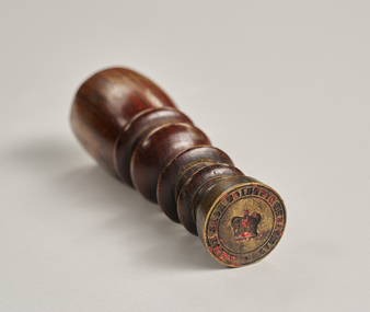 City of Greater Bendigo - Civic Collection
Ceremonial object - Common Seal, Campaspe District Road Board Seal
... Campaspe District Road Board Seal...Campaspe District Road Board...Remnants of red wax remain in seal. Campaspe District Road Board Seal Ceremonial object Common Seal ...Wax seals have been used since the Middle Ages and are primarily used for legitimising and authenticating official documents. This wax seal was used by the Campaspe Road Board (later the Huntly Council). The first president of the Campaspe Road Board was Sir James Joseph Casey who was a member of the municipal council of Sandhurst prior to holding this position in 1861.Circular, brass seal with wooden handle. Remnants of red wax remain in seal. Campaspe District Road Boardhuntly shire (1866-1994), city of greater bendigo administration item -
 Sunshine and District Historical Society Incorporated
Document - Track and Roads of Sunshine
... Details of the first tracks and roads in the district...Sunshine Handwritten notes of The First tracks of the White Invaders 1835 to 1840|Typed notes of The First Tracks of the White Invaders 1835 to 1840 Details of the first tracks and roads in the district Document Track and Roads of Sunshine ...Handwritten notes of The First tracks of the White Invaders 1835 to 1840|Typed notes of The First Tracks of the White Invaders 1835 to 1840sunshine -
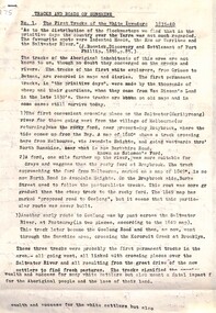
 Geelong Cycling Club
Banner
... geelong cycling club; banner; western district; road championships; horsham; senior; teams time trial; c.dowling; c.bain;...Notably Russell Mockridge was one of the first from the Geelong Cycling Club to compete in the Western District Road Races...."Western District/Road Championships/Horsham 1991/Senior/Teams Time Trial/Third Geelong/C.Dowling/C.Bain"...Notably Russell Mockridge was one of the first from the Geelong Cycling Club to compete in the Western District Road Races. This banner is one of the many awarded in the Western District of Victoria for competitive cycling races from the 1920s onwards. geelong cycling club; banner; western district; road championships; horsham; senior; teams time trial; c.dowling; c.bain; "Western District/Road Championships/Horsham 1991/Senior/Teams Time Trial/Third Geelong/C.Dowling/C.Bain" Grey coloured satin cloth banner. ...This banner is one of the many awarded in the Western District of Victoria for competitive cycling races from the 1920s onwards. Notably Russell Mockridge was one of the first from the Geelong Cycling Club to compete in the Western District Road Races.This banner is one of the many awarded in the Western District of Victoria for competitive cycling races from the 1920s onwards.Grey coloured satin cloth banner. The banner has a yellow fringe attached to the bottom of it and has yellow embossed inscriptions. There is a long yellow cord supported by a piece of dowel threaded through the top of the banner. "Western District/Road Championships/Horsham 1991/Senior/Teams Time Trial/Third Geelong/C.Dowling/C.Bain"geelong cycling club; banner; western district; road championships; horsham; senior; teams time trial; c.dowling; c.bain; -
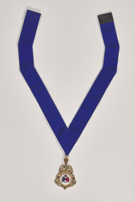 City of Greater Bendigo - Civic Collection
Ceremonial object - Rural City of Marong Medal, Blashki & Sons
... The first local government authority for Marong was the Marong Road District (an early form of single-purpose local government), which was proclaimed on 19 August 1860. ...front; RURAL CITY OF MARONG / verso; FORMED AS / MARONG DISTRICT ROADS BOARD / 27th AUGUST 1861 / PROCLAIMED SHIRE OF MARONG / 23rd DECEMBER 1864 / PROCLAIMED RURAL CITY OF MARONG / 1st OCTOBER 1990...City of Greater Bendigo - Civic Collection Bendigo Town Hall 189-193 Hargreaves St, Bendigo, 3550 goldfields The first local government authority for Marong was the Marong Road District (an early form of single-purpose local government), which was proclaimed on 19 August 1860. ...The first local government authority for Marong was the Marong Road District (an early form of single-purpose local government), which was proclaimed on 19 August 1860. Its boundary was altered twice in 1862 and on 12 December 1864 it was re designated as a shire. It absorbed Raywood Borough in 1915, and was proclaimed a Rural City in 1990. On 2 December 1994, with the creation of Greater Bendigo City Council, it was abolished by being amalgamated with Bendigo City, Eaglehawk Borough, Huntly Shire, part of McIvor Shire, part of Metcalfe Shire and Strathfieldsaye Shire to form Greater Bendigo City.Rural City of Marong Stirling silver drop, plated in 22 ct gold with enamel centre piece. Medallion hangs from a royal blue neck ribbon. front; RURAL CITY OF MARONG / verso; FORMED AS / MARONG DISTRICT ROADS BOARD / 27th AUGUST 1861 / PROCLAIMED SHIRE OF MARONG / 23rd DECEMBER 1864 / PROCLAIMED RURAL CITY OF MARONG / 1st OCTOBER 1990shire of marong, city of greater bendigo ceremonial item -
 Peterborough History Group
Document - Survey of Town of Peterborough, 2014
... Proclamation of road district and Shires, Map of original town blocks and ad for Sale...Peterborough History Group Peterborough great-ocean-road Proclamation of road district and Shires, Map of original town blocks and ad for Sale Displays original township settlement and layout peterborough history peterborough 3270 Photocopies, copies of maps, Document Survey of Town of Peterborough ...Proclamation of road district and Shires, Map of original town blocks and ad for SaleDisplays original township settlement and layoutPhotocopies, copies of maps, peterborough history, peterborough 3270 -
 City of Whittlesea
Document - Correspondence, Council letter to Mrs Moses Thomas 1868, 1878
... Road District Boards were one of the earliest forms of local government in Victoria. ...Road District Boards were one of the earliest forms of local government in Victoria. ...In 1851 Moses Thomas purchased 400 acres, including a half mile frontage to the Plenty River, at Mernda (then known as Morang) where he operated a farm, inn and other business. In 1865 Moses Thomas was appointed Engineer, Clerk and Collector for the Morang District Road Board. In this role he would have been responsible for overseeing the collection of local property rates and the maintenance and construction of local roads and drains. Road District Boards were one of the earliest forms of local government in Victoria. The Morang or Upper Plenty Road District was established in 1862. It covered part of what is today Mernda, Doreen, South Morang, Mill Park and Bundoora. In 1875, the area merged with the Whittlesea Road District to form the Shire of Whittlesea. Moses Thomas briefly served as a Councillor with the Shire of Whittlesea until his death in 1878. Correspondence. Letter, paper, handwritten text with seal. Letter from James Ryan, Shire Secretary, Shire of Whittlesea to Mrs Moses Thomas on the death of Moses 18 May 1878. -
Federation University Historical Collection
Map, Robinson's Ballarat Street Map, c1972, 1970s
... It also includes a district road map....It also includes a district road map. Robinson's Ballarat Street Map, c1972 Map Map ...A coloured fold-out street map of Ballarat. It also includes a district road map.ballarat, map, ballarat streets -
 Sunshine and District Historical Society Incorporated
Artwork, other - Braybrook Shire Hall Deer Park 1885 Painting, n.d
... Occasion for painting not known, but was displayed in Coles, Hampshire Road, Sunshine. Donated to Sunshine & District Historical Society Inc...."Shire Hall, Deer Park 1885. Braybrook road district was redefined as Braybrook Shire in 1871, and this hall, the first municipal building in the area, was erected in 1885. ...Braybrook Shire Hall Ballarat Road Deer Park "Shire Hall, Deer Park 1885. Braybrook road district was redefined as Braybrook Shire in 1871, and this hall, the first municipal building in the area, was erected in 1885. ...Occasion for painting not known, but was displayed in Coles, Hampshire Road, Sunshine. Donated to Sunshine & District Historical Society Inc.A large watercolour painting drawn to life of the Shire Hall, Deer Park in 1885, with a yellow golden building, white picket fence and a gentleman standing dressed in brown suit and white cap."Shire Hall, Deer Park 1885. Braybrook road district was redefined as Braybrook Shire in 1871, and this hall, the first municipal building in the area, was erected in 1885. It was used for shire purposes until the Memorial Hall was built after World War". Note: The Memorial Hall was demolished many years ago and gardens established on the site.braybrook shire hall, ballarat road, deer park -
 Federation University Historical Collection
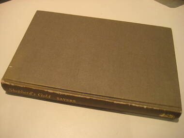
Book, C.E. Sayers, Shepherd's Gold: The Story of Stawell, 1966 (exact)
... Contents include Gold, squatters, Ayreys of Warranooke, Diggings, Reefs, Local Government, Road District, Shire, Borough, Town, Hospital, schools, Churches, Growth of Settlement, Claim Jumps, Sheep, Farming, Water, Grampians, Magdala, Callawadda, Deap Lead, Glenorchi, Great Western, Green's Creek, Marnoo, Wal Wal....Contents include Gold, squatters, Ayreys of Warranooke, Diggings, Reefs, Local Government, Road District, Shire, Borough, Town, Hospital, schools, Churches, Growth of Settlement, Claim Jumps, Sheep, Farming, Water, Grampians, Magdala, Callawadda, Deap Lead, Glenorchi, Great Western, Green's Creek, Marnoo, Wal Wal. ...One of the 6 University of Ballarat campuses is at Stawell.Grey hard covered book of 194 pages covering the history of Stawell, Victoria. Contents include Gold, squatters, Ayreys of Warranooke, Diggings, Reefs, Local Government, Road District, Shire, Borough, Town, Hospital, schools, Churches, Growth of Settlement, Claim Jumps, Sheep, Farming, Water, Grampians, Magdala, Callawadda, Deap Lead, Glenorchi, Great Western, Green's Creek, Marnoo, Wal Wal.education, religion, stawell victoria, stawell -
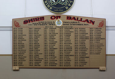 Ballan Shire Historical Society
Memorabilia, Ballan Shire President's Board
... This Memorial Board lists all the Presidents of the old Ballan Shire and is a complete record from the creation of a Road District in 1862, then the creation of a Shire in 1864 through to when the Shire was amalgamated into the Moorabool Shire in 1994....Ballan Shire Historical Society 45-47 Steiglitz St Ballan goldfields This Memorial Board lists all the Presidents of the old Ballan Shire and is a complete record from the creation of a Road District in 1862, then the creation of a Shire in 1864 through to when the Shire was amalgamated into the Moorabool Shire in 1994. ...This Memorial Board lists all the Presidents of the old Ballan Shire and is a complete record from the creation of a Road District in 1862, then the creation of a Shire in 1864 through to when the Shire was amalgamated into the Moorabool Shire in 1994.A large memorial board listing all the Presidents of the Ballan Shire.See photographballan shire president's board., ballan local government -
 Glen Eira City Council History and Heritage Collection
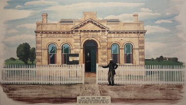
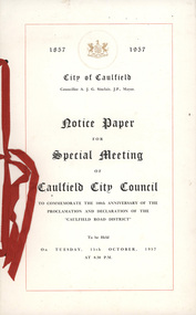
Notice, Arbuckle Waddell Pty Ltd, "Notice Paper for Special Meeting of Caulfield City Council", c. 1957
... Notice paper generated by council documenting the minutes of a special meeting of Caulfield City Council to commemorate the 100th anniversary of the proclamation and declaration of the "Caulfield Road District" and held as part of the 1957 Centenary of Caulfield Celebrations....Glen Eira City Council History and Heritage Collection Corner Glen Eira and Hawthorn Roads Caulfield melbourne Notice paper generated by council documenting the minutes of a special meeting of Caulfield City Council to commemorate the 100th anniversary of the proclamation and declaration of the "Caulfield Road District" and held as part of the 1957 Centenary of Caulfield Celebrations. ...Notice paper generated by council documenting the minutes of a special meeting of Caulfield City Council to commemorate the 100th anniversary of the proclamation and declaration of the "Caulfield Road District" and held as part of the 1957 Centenary of Caulfield Celebrations.Paper notice printed in black ink on cream colour paper, bound with red ribbon. 2x A3 sheets of paper folded to make a booklet including a cover and inside pages include an agenda; image of the Caulfield Town Hall; Council summons and a list of the Caulfield City Council. -
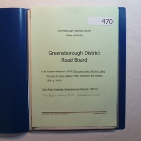 Greensborough Historical Society
Folder, Greensborough District Roads Board, 1847o
... Contains documents relating to the Greensborough District Roads Board....Contains documents relating to the Greensborough District Roads Board. Greensborough District Roads Board Folder Greensborough Historical Society ...Contents: The open road in Victoria [excerpt] by R H Croll; Newspaper articles on early road proposals in Greensborough area; Newspaper article from The Argus on Embezzelment of monies from Roads Board.20-page plastic binder, blue cover. Contains documents relating to the Greensborough District Roads Board.greensborough district roads board, robert henderson croll, charles buck -
 Sunshine and District Historical Society Incorporated
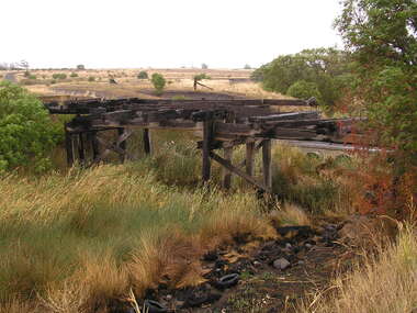
Photograph - Beattys Road Bridge Rockbank Photographs, John Alchin, 2008
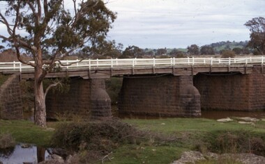
... Rockbank was once part of the Braybrook Road District. In, 1871 the Road District became the Shire of Braybrook. ...Brimbank Library, 301 Hampshire Road, Sunshine 3020. melbourne Rockbank was once part of the Braybrook Road District. In, 1871 the Road District became the Shire of Braybrook. ...Rockbank was once part of the Braybrook Road District. In, 1871 the Road District became the Shire of Braybrook. In 1916, this district was transferred to the Shire of Melton. In 1951, further land was lost to the Shire of Melton. During the early days of the Ballarat gold rush, Beatty's Road was one of the main routes from Melbourne to Ballarat via Keilor . In December 1854, troops of the 12th and 40th Regiments marching to suppress the Eureka Stockade would have used this route before stopping at the Rockbank Inn, which was located on Beatty's Road, further west towards Melton. One of the photographs captures a Terrestrial Road surface (Local Blue Stone), one of the district's early sealed section of road. 5644.01 - Beattys Road Bridge Rockbank 2008 Photo 01.JPG 5644.02 - Beattys Road Bridge Rockbank 2008 Photo 02.JPG 5644.03 - Beattys Road Terrestrial Road Surface Rockbank 2008 Photo 04.JPG 5644.04 - Beattys Road Paddocks Rockbank 2008 Photo 03.JPGbeatty's road, rockbank, rockbank inn, terrestrial road -
 City of Whittlesea
Photograph - Photographs - Bridges, Moses Thomas bridge over the Plenty River 1970, 1970
... Commissioned by Moses Thomas, Secretary Morang District Road Board 1867...City of Whittlesea 25 Ferres Boulevard South Morang melbourne bridges Moses Thomas Mernda Bridge Inn Road Bluestone bridge across the Plenty River, Mernda. Commissioned by Moses Thomas, Secretary Morang District Road Board 1867 Moses Thomas bridge over the Plenty River 1970 Photograph Photographs - Bridges ...Bluestone bridge across the Plenty River, Mernda. Commissioned by Moses Thomas, Secretary Morang District Road Board 1867bridges, moses thomas, mernda, bridge inn road -
Buninyong Visitor Information Centre
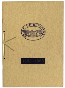
Document - Booklet, Shire of Buninyong 1858-1983, 1983
... Commemorates the 125th Anniversay of the first meeting of the Buninyong District Road Board....Commemorates the 125th Anniversay of the first meeting of the Buninyong District Road Board. Shire of Buninyong 1858-1983 Document Booklet ...Contains notice of Meeting; motions; copy of Government Gazette entry of 1858; list of Mayors and Presidents; chronology of eventsBeige coloured card cover with printed gloss. Commemorates the 125th Anniversay of the first meeting of the Buninyong District Road Board.Handwritten notes throughout the document.local government, buninyong, councils -
 Federation University Historical Collection
Book, Waller & Chester Printers, Shire of Buninyong 1858-1983, 1983
... ...buninyong road district...Documents special meeting of Buninyong Shire Council held on 30 August 1983 to commemorate the 125th anniversary of the first meeting of the Buninyong District Road Board.. Includes images of four generations of Archibald Fisken, photographic copy of Victoria Government Gazette proclamations of the Buninyong Road District, details of inaugural meeting and minutes of the first and second meetings, members of council 1983, a list of Chairmen, Mayors and Presidents and extracts from past records....Barker Library (top floor) Mount Helen goldfields Documents special meeting of Buninyong Shire Council held on 30 August 1983 to commemorate the 125th anniversary of the first meeting of the Buninyong District Road Board.. Includes images of four generations of Archibald Fisken, photographic copy of Victoria Government Gazette proclamations of the Buninyong Road District, details of inaugural meeting and minutes of the first and second meetings, members of council 1983, a list of Chairmen, Mayors and Presidents and extracts from past records. buninyong shire council buninyong road district archibald fisken local government Shire of Buninyong 1858-1983 Beige soft covered book 14 pages with images of four Archibald Fisken, KW McManus and other details related to the 100 years of the Bininyong Shire Council. ...Documents special meeting of Buninyong Shire Council held on 30 August 1983 to commemorate the 125th anniversary of the first meeting of the Buninyong District Road Board.. Includes images of four generations of Archibald Fisken, photographic copy of Victoria Government Gazette proclamations of the Buninyong Road District, details of inaugural meeting and minutes of the first and second meetings, members of council 1983, a list of Chairmen, Mayors and Presidents and extracts from past records.Beige soft covered book 14 pages with images of four Archibald Fisken, KW McManus and other details related to the 100 years of the Bininyong Shire Council. Ink on paper.Shire of Buninyong 1858-1983buninyong shire council, buninyong road district, archibald fisken, local government