Showing 466 items matching " transport map"
-
 Melbourne Tram Museum
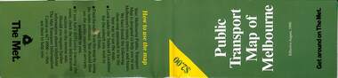
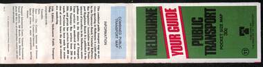
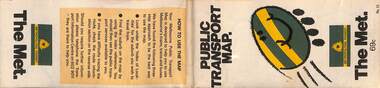
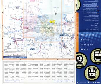
Map, The Met, Public Transport Map of Melbourne - Get around on The Met, 8/1990
... Public Transport Map of Melbourne - Get around on The Met...Melbourne transport map - dated August 1990 - includes a map of the ticket zones, and The Met contact details and notes where tickets can be obtained from...Fold out map (36 sections 9 across x 4 deep), "Public Transport Map of Melbourne", coloured of Melbourne's Tram and Bus routes, route numbers, rail lines, detailed for the central part of Melbourne and the outer Metropolitan services....Public Transport Map of Melbourne - Get around on The Met Map The Met ...Melbourne transport map - dated August 1990 - includes a map of the ticket zones, and The Met contact details and notes where tickets can be obtained fromYields information about Melbourne public transport services in August 1990Fold out map (36 sections 9 across x 4 deep), "Public Transport Map of Melbourne", coloured of Melbourne's Tram and Bus routes, route numbers, rail lines, detailed for the central part of Melbourne and the outer Metropolitan services.tramways, melbourne, tram services, bus services, railways, maps, zones -
 Melbourne Tram Museum
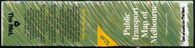
Map, The Met, Public Transport Map of Melbourne - Get around on The Met, 8/1989
... Public Transport Map of Melbourne - Get around on The Met...Melbourne transport map - dated August 1989 - zone ticket system, has a photo of the front of B2 2004, includes a map of the ticket zones, and The Met contact details....Fold out map (36 sections 9 across x 4 deep), "Public Transport Map of Melbourne", coloured of Melbourne's Tram and Bus routes, route numbers, rail lines, detailed for the central part of Melbourne and the outer Metropolitan services....Public Transport Map of Melbourne - Get around on The Met Map The Met ...Melbourne transport map - dated August 1989 - zone ticket system, has a photo of the front of B2 2004, includes a map of the ticket zones, and The Met contact details.Yields information about Melbourne public transport services in August 1989.Fold out map (36 sections 9 across x 4 deep), "Public Transport Map of Melbourne", coloured of Melbourne's Tram and Bus routes, route numbers, rail lines, detailed for the central part of Melbourne and the outer Metropolitan services.tramways, melbourne, tram services, bus services, railways, maps, zones -
 Melbourne Tram Museum
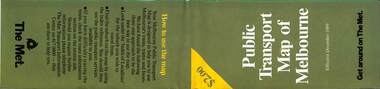
Map, The Met, Public Transport Map of Melbourne - Get around on The Met, 12/1989
... Public Transport Map of Melbourne - Get around on The Met...Melbourne transport map - dated December 1989 - scratch ticket system, has a photo of the front of B2 2004, includes a map of the ticket zones, and The Met contact details....Fold out map (36 sections 9 across x 4 deep), "Public Transport Map of Melbourne", coloured of Melbourne's Tram and Bus routes, route numbers, rail lines, detailed for the central part of Melbourne and the outer Metropolitan services....Public Transport Map of Melbourne - Get around on The Met Map The Met ...Melbourne transport map - dated December 1989 - scratch ticket system, has a photo of the front of B2 2004, includes a map of the ticket zones, and The Met contact details.Yields information about Melbourne public transport services in December 1989 following the introduction of Scratch tickets.Fold out map (36 sections 9 across x 4 deep), "Public Transport Map of Melbourne", coloured of Melbourne's Tram and Bus routes, route numbers, rail lines, detailed for the central part of Melbourne and the outer Metropolitan services.tramways, melbourne, tram services, bus services, railways, maps, zones, scratch tickets -
 Sunshine and District Historical Society Incorporated
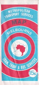
Map - Joseph 'Joe' Wlodarczyk Collection - Metropolitan Transport Services Map, No Date
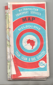
... Joseph 'Joe' Wlodarczyk Collection - Metropolitan Transport Services Map...This combined public transport map provides information on services operated by the Melbourne and Metropolitan Tramways Board, private bus operators and Victorian Railways, Bus Proprietors' Association and the Transport Regulations Board. ...Metropolitan Transport Services Map Melbourne Tram, train & Bus Services 15c...map shows the St. Albans electrification line stopping at the St. Albans Railway Station. Railways Bus Routes Tramlines Metropolitan Transport Services Map Melbourne Tram, train & Bus Services 15c Fold out paper map Map Joseph 'Joe' Wlodarczyk Collection - Metropolitan Transport Services Map ...This combined public transport map provides information on services operated by the Melbourne and Metropolitan Tramways Board, private bus operators and Victorian Railways, Bus Proprietors' Association and the Transport Regulations Board. It was published in the interest of travelers in the Melbourne metropolitan area.This map shows Melbourne's transport network prior to the City Loop being built. Locally the map shows the St. Albans electrification line stopping at the St. Albans Railway Station.Metropolitan Transport Services Map Melbourne Tram, train & Bus Services 15crailways, bus routes, tramlines -
 Melbourne Tram Museum
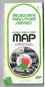
Map, Ministry of Transport, Melbourne Public Transport Map - No. 11, 1980
... Melbourne Public Transport Map - No. 11...Fold out map (27 sections 9 across x 3 deep), "Public Transport Map", coloured of Melbourne's Tram and Bus routes, route numbers, rail lines, detailed for the central part of Melbourne and the outer Metropolitan services....Melbourne Public Transport Map - No. 11 Map Ministry of Transport ...Map No. 11 dated on rear as 1980 - Includes description of tram and bus routes, private bus routes. Has contact details for bookings and lost property etc and how to use the map. Yields information about Melbourne public transport services in 1980Fold out map (27 sections 9 across x 3 deep), "Public Transport Map", coloured of Melbourne's Tram and Bus routes, route numbers, rail lines, detailed for the central part of Melbourne and the outer Metropolitan services.tramways, melbourne, tram services, bus services, railways, maps -
 Melbourne Tram Museum
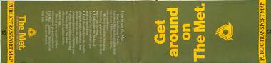
Map, The Met, Public Transport Map - Get around on The Met, c1987
... Public Transport Map - Get around on The Met...Fold out map (36 sections 9 across x 4 deep), "Public Transport Map", coloured of Melbourne's Tram and Bus routes, route numbers, rail lines, detailed for the central part of Melbourne and the outer Metropolitan services....Public Transport Map - Get around on The Met Map The Met ...Undated map - c1987 - Neighbourhood and travelcard tickets, has a photo of the front of B2 2004, includes a map of the travelcard neighbourhoods, commuter passes and The Met contact details.Yields information about Melbourne public transport services in c1987Fold out map (36 sections 9 across x 4 deep), "Public Transport Map", coloured of Melbourne's Tram and Bus routes, route numbers, rail lines, detailed for the central part of Melbourne and the outer Metropolitan services.tramways, melbourne, tram services, bus services, railways, maps, travelcard, neighbourhood tickets -
 Melbourne Tram Museum
Map, Ministry of Transport, Melbourne Public Transport Map - No. 9, 1979
... Melbourne Public Transport Map - No. 9...Fold out map (27 sections 9 across x 3 deep), "Public Transport Map", coloured of Melbourne's Tram and Bus routes, route numbers, rail lines, detailed for the central part of Melbourne and the outer Metropolitan services....Melbourne Public Transport Map - No. 9 Map Ministry of Transport ...Map No. 9 - Includes description of tram and bus routes, private bus routes. Has contact details for bookings and lost property etc and how to use the map. Yields information about Melbourne public transport services in 1979Fold out map (27 sections 9 across x 3 deep), "Public Transport Map", coloured of Melbourne's Tram and Bus routes, route numbers, rail lines, detailed for the central part of Melbourne and the outer Metropolitan services.tramways, melbourne, tram services, bus services, railways, travelcard, maps -
 Melbourne Tram Museum
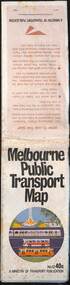
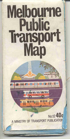
Document, Ministry of Transport, Melbourne Public Transport Map - No. 12, 1982
... Melbourne Public Transport Map - No. 12...Map No. 12 - Includes description of tram and bus routes, private bus routes. On the front cover is composite image of Melbourne public transport vehicles. ...Fold out map (36 sections 9 across x 4 deep), "Public Transport Map", coloured of Melbourne's Tram and Bus routes, route numbers, rail lines, detailed for the central part of Melbourne and the outer Metropolitan services....Melbourne Public Transport Map - No. 12 Document Ministry of Transport ...Map No. 12 - Includes description of tram and bus routes, private bus routes. On the front cover is composite image of Melbourne public transport vehicles. Has contact details for bookings and lost property etc and how to use the map. Priced at 40c, issue No. 12 of c1982. Has details of the then new Travelcard ticket system. Yields information about Melbourne public transport services in 1982.Fold out map (36 sections 9 across x 4 deep), "Public Transport Map", coloured of Melbourne's Tram and Bus routes, route numbers, rail lines, detailed for the central part of Melbourne and the outer Metropolitan services.tramways, melbourne, tram services, bus services, railways, travelcard -
 Melbourne Tram Museum
Map, The Met, "Public Transport Map - No. 13", 1984
... "Public Transport Map - No. 13"...Fold out map (36 sections 9 across x 4 deep), "Public Transport Map", coloured of Melbourne's Tram and Bus routes, route numbers, rail lines, detailed for the central part of Melbourne and the outer Metropolitan services...."Public Transport Map - No. 13" Map The Met ...Map No. 13 undated with the buzzing bee symbol on the front and throughout at the time of the introduction of the neighbourhoods. Includes description of tram and bus routes, private bus routes. Has contact details for bookings and lost property etc and how to use the map. Gives extensive details of the neighbourhood tickets and their used. C1984.Yields information about Melbourne public transport services in 1984.Fold out map (36 sections 9 across x 4 deep), "Public Transport Map", coloured of Melbourne's Tram and Bus routes, route numbers, rail lines, detailed for the central part of Melbourne and the outer Metropolitan services.tramways, melbourne, tram services, bus services, maps -
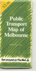
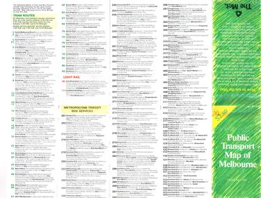
 Melbourne Tram Museum
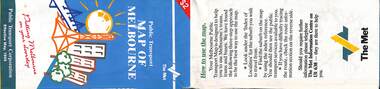
Map, Public Transport Corporation (PTC), "Public Transport Map of Melbourne", 5/1995
... "Public Transport Map of Melbourne"...map. Gives details of the ticketing system, along with photographs of the various modes. Dated May 1995 with a stylised image of some of Melbourne's landmarks on the cover. Published by the Public Transport...Fold out map (36 sections 9 across x 4 deep), "Public Transport Map", coloured of Melbourne's Tram and Bus routes, route numbers, rail lines, detailed for the central part of Melbourne and the outer Metropolitan services...."Public Transport Map of Melbourne" Map Public Transport Corporation (PTC) ...Map Includes description of tram and bus routes, private bus routes, and rail lines. Has contact details for bookings and lost property etc and how to use the map. Gives details of the ticketing system, along with photographs of the various modes. Dated May 1995 with a stylised image of some of Melbourne's landmarks on the cover. Published by the Public Transport Corporation.Yields information about Melbourne public transport services in 1995.Fold out map (36 sections 9 across x 4 deep), "Public Transport Map", coloured of Melbourne's Tram and Bus routes, route numbers, rail lines, detailed for the central part of Melbourne and the outer Metropolitan services.tramways, melbourne, tram services, bus services, maps, railways -
 Melbourne Tram Museum
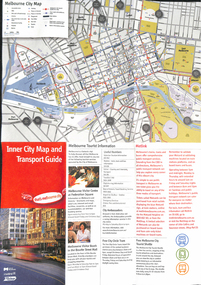
Map, City of Melbourne, "Inner City Transport Map", c1990
... "Inner City Transport Map"...Map... Public Transport...Map - 6 fold DL - full colour titled "Inner City Transport Map", providing information for Tourist Information centres, Metlink. ...Published by City of Melbourne, Melway and Metlink with each of their logos. "Inner City Transport Map" Map City of Melbourne ...Map - 6 fold DL - full colour titled "Inner City Transport Map", providing information for Tourist Information centres, Metlink. Melbourne City Tourist Shuttle, and two maps, one provided by Melway giving a list of attractions. Published by City of Melbourne, Melway and Metlink with each of their logos.trams, tramways, map, public transport, city of melbourne, metlink -
 Melbourne Tram Museum
Map, Metlink, Melbourne's Public Transport Map", 1/2005
... Melbourne's Public Transport Map"...Map titled Melbourne's Public Transport Map" published by Metlink 2005, giving details of tram and bus routes, an overall map of Melbourne showing public transport services, premium stations, general information including Metcard information and ticket types. ...Melbourne's Public Transport Map" Map Metlink ...Map titled Melbourne's Public Transport Map" published by Metlink 2005, giving details of tram and bus routes, an overall map of Melbourne showing public transport services, premium stations, general information including Metcard information and ticket types. See item 8798 for a 2006 version. Yields information Melbourne's public transport network.Map - full colour with card covers, 8 x 5 fold. tramways, maps, railways, buses, metlink, metcard, public transport -
 Melbourne Tram Museum
Map, Metlink, Melbourne's Public Transport Map", 1/2006
... Melbourne's Public Transport Map"...Map titled Melbourne's Public Transport Map" published by Metlink 2006, giving details of tram and bus routes, an overall map of Melbourne showing public transport services, premium stations, general information including Metcard information and ticket types. ...Melbourne's Public Transport Map" Map Metlink ...Map titled Melbourne's Public Transport Map" published by Metlink 2006, giving details of tram and bus routes, an overall map of Melbourne showing public transport services, premium stations, general information including Metcard information and ticket types. See item 8797 for a 2005 version. Yields information Melbourne's public transport network.Map - full colour with card covers, 8 x 5 fold. tramways, maps, railways, buses, metlink, metcard, public transport -
 Ballarat Tramway Museum
Map, Ministry of Transport, "Melbourne Public Transport Map" - "No. 9", 1979
... "Melbourne Public Transport Map" - "No. 9"...Pocket size - folded - public transport map of Melbourne, printed in colour on paper, showing public transport services in greater Melbourne and an index of localities. ..."Melbourne Public Transport Map" - "No. 9" Map Ministry of Transport ...Pocket size - folded - public transport map of Melbourne, printed in colour on paper, showing public transport services in greater Melbourne and an index of localities. The Central zone area shown in detail. On the rear, route numbers and line maps of tram routes and train lines or services. Includes private bus routes. Printed for the Ministry of Transport. Issue No. 9. Dated 1979.trams, tramways, melbourne, map, routes -
 Melbourne Tram Museum
Map, Department of Infrastructure (DOI), "Melbourne's Public Transport Map", Jul. 1999
... "Melbourne's Public Transport Map"...Map - 18 fold - 6 x 3 with colour map of public transport including buses, titled "Melbourne's Public Transport Map", published by the Department of Infrastructure, Effective July 1999. ..."Melbourne's Public Transport Map" Map Department of Infrastructure (DOI) ...Map - 18 fold - 6 x 3 with colour map of public transport including buses, titled "Melbourne's Public Transport Map", published by the Department of Infrastructure, Effective July 1999. Gives rail and tram maps, information on tickets, zones (3 Number) Has The Met contact details and website. Has DOI and State Govt logos. Priced $2.trams, tramways, map, doi, melbourne, the met -
 Melbourne Tram Museum
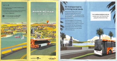
Map, Transport for Victoria, "Manningham Transport Map", c2018
... "Manningham Transport Map"...Pamphlet - 12 fold DL - colour titled "Manningham by Bus" or "Manningham Transport Map", giving a detailed bus and tram map for the City of Manningham, cantered around the Doncaster Shopping centre. ...At the time of entry, the given website "melbournebybus.com.au" went to the PTV website. "Manningham Transport Map" Map Transport for Victoria ...Pamphlet - 12 fold DL - colour titled "Manningham by Bus" or "Manningham Transport Map", giving a detailed bus and tram map for the City of Manningham, cantered around the Doncaster Shopping centre. Covers route 109 and 48. Published by "Transport for Victoria" c2018 - no publication date. The tram portion of the map has been imaged. At the time of entry, the given website "melbournebybus.com.au" went to the PTV website.trams, tramways, maps, manningham, route 48, route 109 -
 Melbourne Tram Museum
Map, The Met, "Public Transport Map of Melbourne", June 1992
... "Public Transport Map of Melbourne"...Map - 36 fold - 9 x 2 x 2- colour map of public transport including buses, titled "Public Transport Map of Melbourne", published by the Public Transport Corporation, Effective June 1992. ...Has The Met contact details. 2 copies held .1 - as above but a 6 fold DL, dated Jan 8, 1995 "Public Transport Map of Melbourne" Map The Met ...Map - 36 fold - 9 x 2 x 2- colour map of public transport including buses, titled "Public Transport Map of Melbourne", published by the Public Transport Corporation, Effective June 1992. Gives rail and tram maps, information on tickets. Has The Met contact details. 2 copies held .1 - as above but a 6 fold DL, dated Jan 8, 1995trams, tramways, map, ptc, melbourne, the met -
 Ballarat Tramway Museum
Map, Ministry of Transport, "Melbourne Public Transport Map" - "No. 12", 1982
... "Melbourne Public Transport Map" - "No. 12"...Pocket size - folded - public transport map of Melbourne, printed in colour on paper, showing public transport services in greater Melbourne, including ticketing information, travelcards and an index of localities. ..."Melbourne Public Transport Map" - "No. 12" Map Ministry of Transport ...Pocket size - folded - public transport map of Melbourne, printed in colour on paper, showing public transport services in greater Melbourne, including ticketing information, travelcards and an index of localities. The Central zone area shown in detail. On the rear, route numbers and line maps of tram routes and train lines or services and fare zones. The first map with the new three zone system of fares. Includes private bus routes. Printed 1982 by Government Printer. Issue No. 12.On inside, a circle route around Flinders, Queen, Little Collins and Swanston St in blue felt pen and arrow in blue ink. On the rear, a sketch map showing the location Charles St, Mantell St and William Road, and a circle around Upfield station.trams, tramways, melbourne, map, routes -
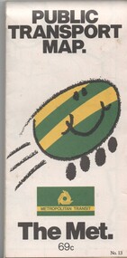 Melbourne Tram Museum
Map, Metropolitan Transit Authority (MTA), "Public Transport Map", c1984
... "Public Transport Map"...Fold out map (36 sections 9 across x 4 deep), "Public Transport Map", coloured of Melbourne's Tram and Bus routes, route numbers, rail lines, detailed for the central part of Melbourne and the outer Metropolitan services. ...Two copies held. "Public Transport Map" Map Metropolitan Transit Authority (MTA) ...Fold out map (36 sections 9 across x 4 deep), "Public Transport Map", coloured of Melbourne's Tram and Bus routes, route numbers, rail lines, detailed for the central part of Melbourne and the outer Metropolitan services. Includes description of tram and bus routes, private bus routes. On the front cover is The Met's Buzz symbol and their logo. Has contact details for bookings and lost property etc and how to use the map. Priced at 69c, issue No. 13 of c1984. Two copies held.trams, tramways, melbourne, map, tram & bus services, railways, the met, neighbourhood tickets -
 Ballarat Tramway Museum
Map, Ministry of Transport and The Met, "Public Transport Map of Melbourne" - "Effective August 1988", 1988
... "Public Transport Map of Melbourne" - "Effective August 1988"...Map - Pocket size - folded - public transport map of Melbourne, printed in colour on art paper, showing public transport services in greater Melbourne, an index of localities. ...On front under The Met logo and above the scale bar is "Effective 1/7/1988". "Public Transport Map of Melbourne" - "Effective August 1988" Map Ministry of Transport and The Met ...Map - Pocket size - folded - public transport map of Melbourne, printed in colour on art paper, showing public transport services in greater Melbourne, an index of localities. The City Saver area shown in detail. On the rear, route numbers, line maps of tram routes, train lines, outer metropolitan services, ticketing information, Transport Neighbourhoods, . Shows the St Kilda and Port Melbourne light rail lines. Price $2. Shows "The Met" logo. On front under The Met logo and above the scale bar is "Effective 1/7/1988". Niltrams, tramways, melbourne, map, routes -
 Melbourne Tram Museum
Map, The Met, "Public Transport Map of Melbourne" - "Effective August 1988", 1988
... "Public Transport Map of Melbourne" - "Effective August 1988"...Map - Pocket size - folded - public transport map of Melbourne, printed in colour on art paper, showing public transport services in greater Melbourne, an index of localities. ...Map - Pocket size - folded - public transport map of Melbourne, printed in colour on art paper, showing public transport services in greater Melbourne, an index of localities. ...Map - Pocket size - folded - public transport map of Melbourne, printed in colour on art paper, showing public transport services in greater Melbourne, an index of localities. The City Saver area shown in detail. On the rear, route numbers, line maps of tram routes, train lines, outer metropolitan services, ticketing information, Transport Neighbourhoods, . Shows the St Kilda and Port Melbourne light rail lines. Price $2. Shows "The Met" logo. On front under The Met logo and above the scale bar is "Effective 1/7/1988".In ink in top left hand corner, "11" in a circle.trams, tramways, melbourne, map, routes -
 Melbourne Tram Museum
Map - Metlink folder - Travel Smart Maps, Travelsmart - Department of Infrastructure, "Melbourne's Public transport Map", 2005 to 2006
... "Melbourne's Public transport Map" ...Detailed map showing rail, tram and bus routes. 2 - 6 x 4 fold map for Moonee Valley - Travelsmart - for public transport, walking and cycling - dated 2005 3 - 7 x 4 fold map for Moreland - Travelsmart - for public transport, walking and cycling - dated October 2006 - includes notes on taxis. 4 - 7 x 4 fold map for Ride to Work day - 5 Oct. 2005..."Melbourne's Public transport Map" Map Metlink folder - Travel Smart Maps Travelsmart - Department of Infrastructure Metlink Melway ...Set of four maps issued by Metlink - 2005 to 2006 contained within a Metlank badge plastic folder. Maps published in association with Melway 1 - 5 x 8 fold map with card cover dated Jan 2005 with a price of $2. Detailed map showing rail, tram and bus routes. 2 - 6 x 4 fold map for Moonee Valley - Travelsmart - for public transport, walking and cycling - dated 2005 3 - 7 x 4 fold map for Moreland - Travelsmart - for public transport, walking and cycling - dated October 2006 - includes notes on taxis. 4 - 7 x 4 fold map for Ride to Work day - 5 Oct. 2005Yields information about Melbourne Public Transport network.Metlink plastic folder containing maps.maps, metlink, public transport, moreland, moonee valley, travelsmart -
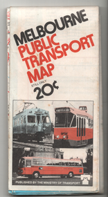 Melbourne Tram Museum
Map, Ministry of Transport, "Melbourne Public Transport Map", c1977
... "Melbourne Public Transport Map"...Map... Tram & Bus Services... Railways... MMTB... Minister For Transport..."Melbourne Public Transport Map" Map Ministry of Transport ...Fold out map (27 sections 9 across x 3 deep), coloured of Melbourne's Tram and Bus routes, route numbers, rail lines, detailed for the central part of Melbourne and insert section for Frankston. On rear description of routes, private bus routes and map of Melbourne metro lines. Has contact details for bookings and lost property etc. Priced 20c Dated 1977, says No. 6 on bottom of rear cover. Note shows route 59 being cut back to the highway.trams, tramways, melbourne, map, tram & bus services, railways, mmtb, minister for transport -
 Ballarat Tramway Museum
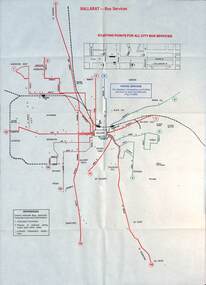
Map - Public Transport Map - Bus, Ministry of Transport, Ballarat, Bendigo & Geelong, 1977
... Public Transport Map - Bus - ...maps, c1977 show the bus routes for each of Ballarat, Bendigo and Geelong along with railways. Provides information on each route, summary timetables, who operated the route and places of interest. Published by the Ministry of Transport...Demonstrates a public transport map published by the Ministry of Transport. buses maps Ballarat Bendigo Geelong timetables railways On each map "7/77" in ink. ...Set of three maps, c1977 show the bus routes for each of Ballarat, Bendigo and Geelong along with railways. Provides information on each route, summary timetables, who operated the route and places of interest. Published by the Ministry of Transport in conjunction with the Transport Regulation Board, Bus Proprietors Association and VicRail. By comparison with the posters issued at the time of tram closure, can see the changes made to the routes in each city. See item 6813 for Ballarat, 6812 for Geelong, and 6814 for Bendigo.Demonstrates a public transport map published by the Ministry of Transport.Set of three 10 fold maps printed in colour to pocket size.On each map "7/77" in ink.buses, maps, ballarat, bendigo, geelong, timetables, railways -
 Ballarat Tramway Museum
Map, Ministry of Transport, "Metropolitan Transport Services Map - Melbourne - Tram and Bus Services", c1970
... "Metropolitan Transport Services Map - Melbourne - Tram and Bus Services"...Map... Public Transport...Pocket size - folded - public transport map of Melbourne, printed in colours showing the bus, train and tram routes around Melbourne. ...Ballarat Tramway Museum South Gardens Reserve Wendouree Parade Ballarat Ballarat goldfields Trams tramways Melbourne Map Public Transport Routes Pocket size - folded - public transport map of Melbourne, printed in colours showing the bus, train and tram routes around Melbourne. ...Pocket size - folded - public transport map of Melbourne, printed in colours showing the bus, train and tram routes around Melbourne. Has a cover price of 10c. No printing date shown, but c1970 as distances are still in imperial, the West gate bridge is shown, though so is the Williamstown Ferry. Gives telephone numbers in 6 digit figures. Lists route numbers for trams, tramways board bus services and private services. Gives various telephone numbers for further information. Notes the map is a combined effort of the Tramways Board, Victorian Railways, Bus Proprietors' Association and the Transport Regulation Board. Single sheet of paper folded in 9 x 3 folds.trams, tramways, melbourne, map, public transport, routes -
 Ballarat Tramway Museum
Map, Ministry of Transport, "Melbourne Transport Services Map - Tram, Train and Bus Services", 1974
... "Melbourne Transport Services Map - Tram, Train and Bus Services"...map...tram and bus services...MMTB...Minister for Transport..."Melbourne Transport Services Map - Tram, Train and Bus Services" Map Ministry of Transport ...Coloured map of Melbourne's Tram and Bus routes, route numbers, rail lines, detailed for the central part of Melbourne and insert section for Frankston. On rear description of routes, private bus routes and map of Melbourne metro lines. Has contact details for bookings and lost property etc. Priced 15c. Inscription dates the map as 1974. Yields information about public transport services in Melbourne as a comparison with that of Ballarat.Fold out map (27 sections 9 across x 3 deep), printed on paper.trams, tramways, railways, melbourne, map, tram and bus services, mmtb, minister for transport, public transport -
 Melbourne Tram Museum
Map, Ministry of Transport, "Metropolitan Transport Services Map - Melbourne Tram, Train and Bus Services", 10/1971
... "Metropolitan Transport Services Map - Melbourne Tram, Train and Bus Services"...Map... Tram & Bus Services... Railways... MMTB... Minister For Transport...Has map scale in miles. 2nd copy added 16/7/2014 "Metropolitan Transport Services Map - Melbourne Tram, Train and Bus Services" Map Ministry of Transport Graphic Print Services ...Fold out map (27 sections 9 across x 3 deep), coloured of Melbourne's Tram and Bus routes, route numbers, rail lines, detailed for the central part of Melbourne. On rear description of routes, private bus routes and map of Melbourne metro lines. Has contact details for bookings and lost property etc. Priced at 10c. Launched in a newspaper advert 26/10/1971. Has map scale in miles. 2nd copy added 16/7/2014On front cover in ink "#1" in top right hand corner and "4 G 33" along bottom edge.trams, tramways, melbourne, map, tram & bus services, railways, mmtb, minister for transport -
 Melbourne Tram Museum
Map, Ministry of Transport, "Melbourne Transport Services Map - Tram, Train and Bus Services", c1975
... "Melbourne Transport Services Map - Tram, Train and Bus Services"...Map... Tram & Bus Services... Railways... MMTB... Minister For Transport...Not dated, but circa 1975 - has map scale in kms and route 59 to Essendon Airport still extends into Airport. 2nd copy added 16/7/2014. See Reg Item 521 for issue No.. 2, 1974. "Melbourne Transport ...Fold out map (27 sections 9 across x 3 deep), coloured of Melbourne's Tram and Bus routes, route numbers, rail lines, detailed for the central part of Melbourne and insert section for Frankston. On rear description of routes, private bus routes and map of Melbourne metro lines. Has contact details for bookings and lost property etc. Not priced. Not dated, but circa 1975 - has map scale in kms and route 59 to Essendon Airport still extends into Airport. 2nd copy added 16/7/2014. See Reg Item 521 for issue No.. 2, 1974.On front cover in ink "issue #3" in top right hand corner and "4 G 33" along bottom edge.trams, tramways, melbourne, map, tram & bus services, railways, mmtb, minister for transport -
 Melbourne Tram Museum
Map, Ministry of Transport, "Melbourne Transport Services Map - Tram, Train and Bus Services", c1974
... "Melbourne Transport Services Map - Tram, Train and Bus Services"...Map... Tram & Bus Services... Railways... MMTB... Minister For Transport...Priced 15c Inscription dates the map as 1974. Two copies held. "Melbourne Transport Services Map - Tram, Train and Bus Services" Map Ministry of Transport ...Fold out map (27 sections 9 across x 3 deep), coloured of Melbourne's Tram and Bus routes, route numbers, rail lines, detailed for the central part of Melbourne and insert section for Frankston. On rear description of routes, private bus routes and map of Melbourne metro lines. Has contact details for bookings and lost property etc. Priced 15c Inscription dates the map as 1974. Two copies held.On front cover in ink "#3" in top right hand corner and "4 G 33 1974" along bottom edge of the first copy.trams, tramways, melbourne, map, tram & bus services, railways, mmtb, minister for transport -
 Melbourne Tram Museum
Map, Ministry of Transport, "Melbourne Transport Services Map - Tram, Train and Bus Services", 1975-1976
... "Melbourne Transport Services Map - Tram, Train and Bus Services"...Map... Tram & Bus Services... Railways... MMTB... Minister For Transport...map of Melbourne metro lines. Has contact details for bookings and lost property etc. Priced 20c possible 1975-1976 - has 1041 and silver train on front cover. "Melbourne Transport ...Fold out map (27 sections 9 across x 3 deep), coloured of Melbourne's Tram and Bus routes, route numbers, rail lines, detailed for the central part of Melbourne and insert section for Frankston. On rear description of routes, private bus routes and map of Melbourne metro lines. Has contact details for bookings and lost property etc. Priced 20c possible 1975-1976 - has 1041 and silver train on front cover.On front cover in ink "3" in top right hand corner and "4 G 33 " along bottom edge.trams, tramways, melbourne, map, tram & bus services, railways, mmtb, minister for transport