Showing 188 items matching " victoria hill map"
-
 Bendigo Historical Society Inc.
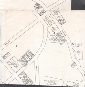
Map - VICTORIA HILL - MAP - HAPPY VALLEY RD - DARE ST
... VICTORIA HILL - MAP - HAPPY VALLEY RD - DARE ST....Victoria Hill... Victoria Hill - Map - Happy Valley Road - Dare Street...History House 11 Mackenzie Street Bendigo goldfields MAP Bendigo victoria hill Victoria Hill Victoria Hill - Map - Happy Valley Road - Dare Street W Rae J Rae Small map showing some blocks of land in the Happy Valley Road, Dare Street and Wells Streets area. ...Small map showing some blocks of land in the Happy Valley Road, Dare Street and Wells Streets area. Three of the blocks are in the name of Rae. Notes by Albert Richardson.map, bendigo, victoria hill, victoria hill, victoria hill - map - happy valley road - dare street, w rae, j rae -
 Bendigo Historical Society Inc.
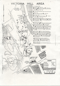
Document - VICTORIA HILL - VICTORIA HILL AREA MAP
... VICTORIA HILL - VICTORIA HILL AREA MAP...MAP...Bendigo...Victoria Hill...Photocopied map on cream paper. Map is the Victoria Hill area showing the locations of the Gold Mines Hotel, John Brown Factory and W Rae's Home. ...Map also shows mine shafts and open cuts. Document VICTORIA HILL - VICTORIA HILL AREA MAP ...Photocopied map on cream paper. Map is the Victoria Hill area showing the locations of the Gold Mines Hotel, John Brown Factory and W Rae's Home. Map also shows mine shafts and open cuts.map, bendigo, victoria hill, victoria hill map, gold mines hotel, john brown factory, w rae's home, victoria consols, adventure and advance open cut, great central victoria, rae's open cut, victoria qiartz, ballerstedt's open cut, lansell's '180', north old chum, central nell gwynne -
 Bendigo Historical Society Inc.
Document - VICTORIA HILL - SKETCH MAP - VICTORIA HILL
... VICTORIA HILL - SKETCH MAP - VICTORIA HILL......Victoria Hill... Sketch Map...Document VICTORIA HILL - SKETCH MAP - VICTORIA HILL ...Hand drawn sketch map of mines and depth. Some have distances between the shafts. Mines mentioned are: Great Central Victoria, Ballerstedt, Humboldt and Sterry's.document, gold, victoria hill, sketch map - victoria hill, great central victoria, ballerstedt, humboldt, sterry's -
 Bendigo Historical Society Inc.
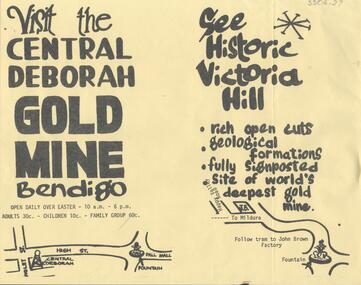
Document - CENTRAL DEBORAH GOLD MINE: ADVERTISING FLYER
... 'Visit the Central Deborah Gold Mine Bendigo' 'See Historic Victoria Hill'. Handrawn mud maps for each site on bottom of page....'Visit the Central Deborah Gold Mine Bendigo' 'See Historic Victoria Hill'. Handrawn mud maps for each site on bottom of page. ...BHS CollectionA4 advertising flyer,yellow background, black text. 'Visit the Central Deborah Gold Mine Bendigo' 'See Historic Victoria Hill'. Handrawn mud maps for each site on bottom of page.bendigo, mining, crentral deborah gold mine -
 Bendigo Historical Society Inc.
Document - LONG GULLY HISTORY GROUP COLLECTION: VICTORIA HILL
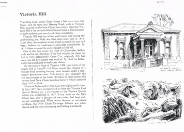
... of the Victoria Hill Area showing streets and the New Chum Anticline, a sketch of Ballerstedt's Open Cut and a Key to Victoria Hill Area Map. ... of the Victoria Hill Area showing streets and the New Chum Anticline, a sketch of Ballerstedt's Open Cut and a Key to Victoria Hill Area Map. ...Three pages numbered 18/19, 20/21 and 22/23 titled Victoria Hill. First page has some information on Victoria Hill, a sketch of W Rae's Home and Rae's Open cut. The second page has a map of the Victoria Hill Area showing streets and the New Chum Anticline, a sketch of Ballerstedt's Open Cut and a Key to Victoria Hill Area Map. The third page mentions the Victoria Quartz mine, Tributors and quartz roasting. It also has sketch of a 20 Head Crushing Battery, Victoria Hill.bendigo, history, long gully history group, the long gully history group - victoria hill, gold mines hotel, christopher ballerstedt, theodore ballerstedt, ballerstedt's open cut, lansell's 180 mine, little 180 mine, new chum syncline battery, victoria reef quartz mining co, victoria quartz, new chum drainage scheme, a roberts and sons, tributors, william rae's bon accord mine and open cut, william rae, adventure and advance open cuts, central nell gwynne, heinz butcher shop -
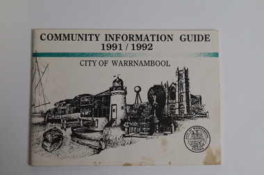 Warrnambool and District Historical Society Inc.
Booklet - Booklet Collection: City of Warrnambool Tourist Guides, Collett, Bain and Gaspar, Warrnambool
... map of the South West Region of Victoria. [.14] A 48 page colour booklet on glossy paper. The front cover has white writing on a blue background and includes photographs of the Twelve Apostles, the Promenade walk, Flagstaff Hill and a southern right whale's tail. ...map of the South West Region of Victoria. [.14] A 48 page colour booklet on glossy paper. The front cover has white writing on a blue background and includes photographs of the Twelve Apostles, the Promenade walk, Flagstaff Hill and a southern right whale's tail. ...This is a collection of sixteen tourist guides dating from the mid 1970's to 2013. These contain listings of businesses, accommodation, eateries and events in Warrnambool and district. They also include maps of Warrnambool and surrounds, advertising and photographs of various attractions. While mainly covering Warrnambool a small number of the guides cover the South West Region. These directories have mainly been published by the Warrnambool City Council and are a selection of the types of information provided to visitors at the Tourist information centre during this time period.These tourist guides give snapshots of the City of Warrnambool for the years covered and will be useful for research.[.1] An 8 page paper booklet with black printing and a black & white photo of the pond at the Botanical Gardens on the front cover. [.2] two photocopied A4 black and white pages from the book "On the Trail" K Winser 1956 (Main Roads of Australia) [.3] A trifold colour brochure with a stylised map of the coast on the yellow and blue front cover. The inside has stylised colour drawings on Warrnambool attractions. The rear cover has coloured photographs of bush, Liebig Street and Fletcher Jones gardens [.4] A trifold black and white brochure with a black line drawing of a whale on the front cover. [.5] A trifold white card with mauve printing. The front cover has a line drawing of the former Timor Street post office and a map of businesses and landmarks in Timor Street. The reverse side contains a brief history of Warrnambool. [.6] A 98 page stapled booklet with a foreword by Vanda Savill. There are 4 pages of coloured photographs. The remainder are black and white photographs. The front cover is purple with white writing in the lower third. There is an outline of the coast and five colour photographs of district attractions. The inside middle page has a map of the Western wonderland region. The content covers towns in this area. Content relating to Warrnambool is in the last six pages. [.7] Twelve loose photocopied black and white pages. The front cover has the Warrnambool Premier Town 1988-1991 logo and a photo of a Southern Right Whale and calf. The bottom right hand corner has a Standard Warrnambool logo. [.8] 44 page booklet printed with blue ink. The staples have been removed. The glossy front cover has blue printing with a coloured photo of Flagstaff Hill Maritime Village pond. The centre pages has a fold out map of the City of Warrnambool. The rear cover has photos of The Twelve Apostles and Hopkins Falls. [.9] 4 loose photocopied pages with Warrnambool Library and Corangamite Regional Library Service Warrnambool City Library black ink stamps. The front page line drawing illustrations of Warrnambool attractions [.10] A single sheet of glossy white paper folded in half to make four pages. The front page has a Warrnambool premier town logo 1979-1982 and blue printing and a visitor survey. [.11] A conference pack of light card folded to make a pocket containing three brochures, a shipwreck coast tourist directory and a Australian Heritage Parks Association conference program dated 24 to 27 May 1992. The front cover of the pack has green writing over a stylised upward arrow. There is a City of Warrnambool logo in the top right hand corner and two film strips diagonally across the cover containing photographs of Warrnambool. The rear cover has a coloured Warrnambool Premier Town logo. [.12] A 63 page stapled booklet with coloured photographs of Warrnambool. The front cover has black writing on white background. There is a coloured photograph of Flagstaff Hill in the middle of the cover and a Warrnambool City and Visit Victoria logos on the lower edge. The middle pages has a coloured of the city of Warrnambool with an inset map of Allansford. [.13] A single large sheet of white paper folded in ten to make a brochure. The front cover has black printing. The rear cover has a purple ink stamp for the City of Warrnambool Tourist Information Centre. When folded out the reverse side has a green, grey and white map of the South West Region of Victoria. [.14] A 48 page colour booklet on glossy paper. The front cover has white writing on a blue background and includes photographs of the Twelve Apostles, the Promenade walk, Flagstaff Hill and a southern right whale's tail. The rear cover has photographs of The Twelve apostles, a passenger train from Melbourne passing the Lake Pertobe playground, and a rural scene. There is white writing and a white Warrnambool City logo on a blue background. The centre pages have a stylised green and blue map of the city of Warrnambool. [.15] A 48 page colour booklet on glossy paper. The front cover has white writing over colour photographs of two people at a lookout, Flagstaff Hill, three southern right whales and a child at the Lake Pertobe playground. The lower edge has blue upper case writing on a white background. The rear cover has a colour photograph of the Twelve Apostles. The lower white border on the rear covers has a a blue and green City of Warrnambool logo and blue writing. The centre pages have a stylised green and blue map of the city of Warrnambool. [.16] A 64 page colour booklet on glossy paper. The front cover has black writing on a black background and there is a photograph of a southern right whale's tail. The lower edge has the Warrnambool City and Visit Victoria Logos. The centre pages have maps of Warrnambool and surrounds. [.1] This week in Warrnambool Vol 2 No. 5 Thurs 1st Feb. For the time of your life [.2] Warrnambool Way [.3] Warrnambool The Holiday Host on the South West Coast with compliments City of Warrnambool and Warrnambool Chamber of Commerce [.4] MMI Insurance presents Whales Giants of the Deep Whale Watcher's Logbook Warrnambool [.5] Warrnambool History began in Timor Street [.6] Western Wonderland Tourist Association [.7] A Premier Arrow Tour of Warrnambool Victoria's Premier Town Australia's Southern Right Whale Nursery [.8] Warrnambool The Heart of Victoria's Great Southwest Visitor's Handbook [.9] What to see in Warrnambool Victoria's Premier City 1979-1982 [.10] Win a Free Holiday & $200 Cash in Victoria's Premier Town [.11] Advancing Warrnambool together! [.12] Great Ocean Road Warrnambool Official Visitor Guide [.13] Tourist guide to the South West Region Victoria All it needs is you [.14] Warrnambool visitor guide 2005 the great ocean road experience attractions accommodation entertainment dining [.15] Warrnambool Visitor Guide 2006 the great ocean road experience Attractions Accommodation Entertainment Dining [.16] Official Visitors' Guide Warrnambool Victoria Australia Discover the Great Ocean Road warrnambool, warrnambool tourist guides -
 Warrnambool and District Historical Society Inc.
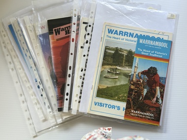
Booklet - Warrnambool Visitor's Handbooks 1979-2024, Collett, Bain and Gaspar, Printers, 1979-2014
... maps of Warrnambool and the surrounding district. The glossy cover has a black background with a colour photograph of the Twelve Apostles taken at sunset. The rear cover has three small of Proudfoot's boathouse on the Hopkins River, Flagstaff Hill, and the main beach area. The front cover has black writing inside to peach coloured rectangles. The inside rear cover has a fold out coloured tour map of Western Victoria...maps of Warrnambool and the surrounding district. The glossy cover has a black background with a colour photograph of the Twelve Apostles taken at sunset. The rear cover has three small of Proudfoot's boathouse on the Hopkins River, Flagstaff Hill, and the main beach area. The front cover has black writing inside to peach coloured rectangles. The inside rear cover has a fold out coloured tour map of Western Victoria ...This is a collection of eight Warrnambool Visitor handbooks produced between 1979 and 2014 by the City of Warrnambool Tourist Information Centre. They contain maps of Warrnambool, lists of services, accommodation and tourist attractions as well as many advertisements for local businesses.These handbooks give a useful snapshot of businesses and tourist attractions in Warrnambool for each of the years covered. (1979, 1980, 1986, 1990, 1993, 1994, 1995, 2014)[.1a] A 48 page booklet with white pages and blue printing. The front cover has a coloured photograph of Flagstaff Hill with boats on a man made lake in the foreground looking across Lake Pertobe toward South Warrnambool. [.1b] A coloured bifold brochure. The front cover has a fisherman on a cray-boat holding a crayfish in the lower section. The top quarter has a blue back ground with white printing. The rear cover is red and has small photos of the Hopkins River and the Framlingham Forest. [.2] A 48 page booklet with white pages and black printing. The front cover is white with black writing on the left hand side and a colour photograph of the Loch Ard peacock. The Warrnambool Premier Town stylised logo of seven Norfollk pines above blue waves is in the top right hand corner. There is a blank ink Warrnambool Library stamp underneath the logo. The rear cover has photographs of The Twelve Apostles and the Hopkins Falls and the Premier Town Logo [.3] A 40 page booklet with mainly black printing on white paper. There are three fold out maps of Warrnambool and the surrounding district. The glossy cover has a black background with a colour photograph of the Twelve Apostles taken at sunset. The rear cover has three small of Proudfoot's boathouse on the Hopkins River, Flagstaff Hill, and the main beach area. The front cover has black writing inside to peach coloured rectangles. The inside rear cover has a fold out coloured tour map of Western Victoria. [.4] A 40 page booklet printed on glossy white paper with coloured photographs and black and red printing. The front cover has a photograph of The Twelve Apostles surrounded by a white border. There is red writing in the upper border. There is a sandy coloured writing superimposed across the bottom of the photograph and a Victoria's Shipwreck Coast logo in the bottom right hand corner. [.5] A 44 page booklet printed on white paper with black printing. The cream coloured cover has a pale red rectangle with blue writing on the right hand facing edge and includes two stylised Norfolk pines and with waves underneath. There is is an intersecting blue rectangle with cream printing. [.6] A 48 page booklet printed on white paper with black printing. The cover is brown with a cream vertical strip containing black writing on the right hand side. There is a stylised map from Geelong to Mount Gambier showing the Great Ocean Road across the cover. [.7] A 48 page booklet printed on white paper with black print. The glossy colour cover has a photograph of a Southern Right whale fluke. There is white printing on a the blue background of the sky and sea. The bottom left hand side of the front cover has a Tourism Victoria logo made of jigsaw puzzle pieces. The back cover has a stylised coloured map of The Great Ocean Road located in a white rectangle at the top of the page. Within the rectangle is a small map of Australia locating Victoria and the part of Victoria covered by the map. [.8] A 64 page A5 coloured booklet printed on white pages with black print. The white front cover has black and grey print with a colour photograph of two people holding coffee cups watching four race horses being exercised on the beach and in the water of Lady Bay in the early morning. The bottom right hand corner has a Tourism Victoria logo. The rear cover has a mainly blue back ground with a pink orange and green colour splats contains words advertising the 2015 Fun 4 Kids Festival [.1a] Warrnambool The Heart of Victoria's Great Southwest Visitor's Handbook [.1b] Warrnambool City for all seasons; The Heart of Victoria's Great Southwest [.2] Warrnambool visitor's handbook Warrnambool Premier Town 1979-1982 [.3] Warrnambool Handbook Victoria [.4] Warrnambool The Shipwreck Coast [.5] Welcome to Warrnambool Warrnambool Visitors Handbook 1993-1994 [.6] Welcome to Warrnambool Visitors Handbook 1994-95 Rear cover: Warrnambool Centre of Victoria's Shipwreck Coast on Australia's Great Ocean Road [.7] Warrnambool Shipwreck Coast - Great Ocean Road; You'll love every piece of Victoria; Visitors Handbook [.8] Warrnambool Great Ocean Road Official Visitor Guide; It's a wonderful Warrnambool; You'll love every piece of Victoria visitvictoria.com. Rear Cover Live entertainment.Workshops.Creativity.Action 28 June - 5 July 2015 Australia's Best Children's Festival F4K The ultimate winter school holiday adventure Fun 4 kids festival Warrnambool For more information visit Fun4kids.com.au Warrnambool great Ocean Road Victoriawarrnambool, visitor handbooks, tourist information guides, warrnambool maps -
 Warrnambool and District Historical Society Inc.
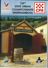
Programme - Booklet, CFA 126 Championship, 2009
... This booklet is a memento of the State Urban Championships that were held in Warrnambool in 2009 (Volunteer Fire Brigades Victoria and Country Fire Authority) warrnambool fire brigade state urban championships (2009) Front Cover: VFBV, Volunteer Fire Brigades Victoria, CWA, 126th State Urban Championships, 7th, 8th and 9th March 2009, Victorian State Senior Championships, Warrnambool 2009, Warrnambool City Council logo This is a booklet of 96 pages containing printed material, maps, advertisements, photographs and tables. The back cover is white with a Powercor Australia symbol in red and printed material. The front cover is multi-coloured with a photograph of the Fire Station at Flagstaff Hill ...The Warrnambool Fire Brigade was formed in 1863. The first fire engine house was in Liebig Street and carters were required to carry water to fire scenes. In 1889 the Council built a new Fire Station on Liebig Street and Warrnambool hosted its own Annual Demonstration in 1894. In 1891 the volunteer brigade became part of the Country Fire Brigade. The Fire Station relocated to Raglan Parade in 1915 and then to Timor Street in 1961. In 1989 the Brigade moved back to Raglan Parade. This booklet is a memento of the State Urban Championships that were held in Warrnambool in 2009 (Volunteer Fire Brigades Victoria and Country Fire Authority)This is a booklet of 96 pages containing printed material, maps, advertisements, photographs and tables. The back cover is white with a Powercor Australia symbol in red and printed material. The front cover is multi-coloured with a photograph of the Fire Station at Flagstaff Hill Maritime Village. The pages are stapled.Front Cover: VFBV, Volunteer Fire Brigades Victoria, CWA, 126th State Urban Championships, 7th, 8th and 9th March 2009, Victorian State Senior Championships, Warrnambool 2009, Warrnambool City Council logowarrnambool fire brigade, state urban championships (2009) -
 Warrnambool and District Historical Society Inc.
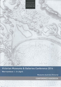
Booklet, Museums Aust Victoria, 2014
... Hill Maritime Village and the Warrnambool Art Gallery. Victorian Museums & Galleries Conference. Front Cover: Museums Australia, Victoria, Victorian Museums & Galleries Conference 2014, Warrnambool 3-4 April, Museums Australia (Victoria), Conference Handbook This is a paper back booklet of 16 pages. It is the Conference Handbook of the Victorian Museums & Galleries Conference 2014 which was held at Warrnambool in April 2014. The pages contain printed material, advertisements, the conference program and information on the conference presenters. The cover has a white background with a map ...This is the handbook for the third annual Victorian Museums & Galleries Conference held in Warrnambool. The conference was run in conjunction with Flagstaff Hill Maritime Village which was celebrating its 40th anniversary. Warrnambool Art Gallery was one of the sponsors of the conference. This handbook is of interest as it tells us of the activities and speakers at a conference which was held in Warrnambool in 2014 and which highlights particularly Flagstaff Hill Maritime Village and the Warrnambool Art Gallery. This is a paper back booklet of 16 pages. It is the Conference Handbook of the Victorian Museums & Galleries Conference 2014 which was held at Warrnambool in April 2014. The pages contain printed material, advertisements, the conference program and information on the conference presenters. The cover has a white background with a map of Warrnambool Bay and town (Stanley 1870) on the front cover and an advertisement on the back cover.Front Cover: Museums Australia, Victoria, Victorian Museums & Galleries Conference 2014, Warrnambool 3-4 April, Museums Australia (Victoria), Conference Handbookvictorian museums & galleries conference. -
 Bendigo Military Museum
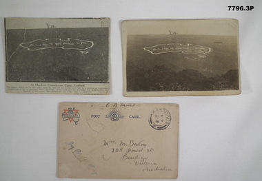
Postcard - POSTCARD - HURDCOTT, AIF CAMP, UK, R. H. Baron, 3. 3/11/1918
... Handwritten in black ink on back: 'This map has been cut in the hill and is only about 10 minutes walk from here, Bob' 3. Handwritten in black ink on front: 'Miss M. Baron, 208 Forest St. Bendigo, Victoria...Handwritten in black ink on back: 'This map has been cut in the hill and is only about 10 minutes walk from here, Bob' 3. Handwritten in black ink on front: 'Miss M. Baron, 208 Forest St. Bendigo, Victoria ...Cards relate to R.H. Baron's time at Hurdcott AIF Camp during 1918. Part of the "Robert H. Baron", No. 3596, and Cooper Collection. See Catalogue No. 1981P for details of Baron's service.1. Black and white newspaper clipping pasted onto a piece of cream card. Clipping features a black and white photograph of a map of Australia carved into the side of a hill. Caption in black type below photograph. 2. Black and white postcard style photograph of a map of Australia carved into the side of a hill. 3. Plain cream coloured postcard with YMCA logo and AIF insignia at the top. Handwritten address on front and handwritten letter on back.1. Handwritten in black ink on back: 'This map has been cut in the hill and is only about 10 minutes walk from here, Bob' 3. Handwritten in black ink on front: 'Miss M. Baron, 208 Forest St. Bendigo, Victoria, Australia'. Stamped in black on top R.H.C. of front: 'Postmark - AIF Camp P.O. No.4, 18,' Handwritten in black ink on back: 'Letter to R.H. Baron's sister Myrtle from Hurdcott Camp dated 3.11.18.'robert h. baron, cooper collection, postcards, hurdcott aif camp -
 Warrnambool and District Historical Society Inc.
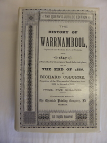
Book, The History of Warrnambool by Richard Osburne, 1980
... map of southwest Victoria (1880). There are five fold-up inserts (sketches, diagrams etc), a number of business advertisements, sepia photographs and sketches and an index. The dust cover includes information on the author. There are 25 chapters, a foreword by the Prime Minister of Australia, Malcolm Fraser and a Preface The proceeds of the book reprint went to Flagstaff Hill Maritime Village....map of southwest Victoria (1880). There are five fold-up inserts (sketches, diagrams etc), a number of business advertisements, sepia photographs and sketches and an index. The dust cover includes information on the author. There are 25 chapters, a foreword by the Prime Minister of Australia, Malcolm Fraser and a Preface The proceeds of the book reprint went to Flagstaff Hill Maritime Village....map of southwest Victoria (1880). There are five fold-up inserts (sketches, diagrams etc), a number of business advertisements, sepia photographs and sketches and an index. The dust cover includes information on the author. There are 25 chapters, a foreword by the Prime Minister of Australia, Malcolm Fraser and a Preface The proceeds of the book reprint went to Flagstaff Hill Maritime Village. ...Richard Osburne (1825-1895) came to Warrnambool in 1847, a pioneer resident in the new settlement. In 1851, with John Wilkinson, he founded Warrnambool’s first newspaper, the Warrnambool Examiner, and issued it weekly for some months until he left the town for the goldfields. Returning in 1853 he resumed publication of the Examiner and continued it, intermittently in its last few years, until 1880. He was acknowledged in his day as the Father of the Warrnambool Press and was a dominant figure in Warrnambool’s early history. He was associated with the establishment of the Aboriginal Reserves, Fire Brigade, Mechanics’ Institute, Warrnambool Council, National School, Presbyterian Church, Public Wants Committee, Villiers Building Society, Fish Protection Society, Dramatic Club, Cricket Club, Otway Gold Exploration Syndicate and other institutions. In 1882 he went to live in Melbourne, returning to publish his ‘History of Warrnambool’ in 1887, a Queen’s Jubilee publication. Richard Osburne’s book is a seminal work of the 19th century history of Warrnambool and its importance cannot be over-emphasized. The original copies of this book are now hard to get and are very valuable. This facsimile is kept because the facsimiles are also now becoming rare and they are good examples of the way a facsimile is reproduced and the reason for the existence of this particular reprint– the importance and usefulness of Osburne’s history and the need to make it accessible to researchers today.This is a facsimile edition (1980) of Richard Osburne's book on the history of Warrnambool from 1847 to 1886. It is a hard cover buff-coloured book with gold lettering on the spine. The dust cover is cream-coloured paper with black writing. Inside the cover is a map of southwest Victoria (1880). There are five fold-up inserts (sketches, diagrams etc), a number of business advertisements, sepia photographs and sketches and an index. The dust cover includes information on the author. There are 25 chapters, a foreword by the Prime Minister of Australia, Malcolm Fraser and a Preface The proceeds of the book reprint went to Flagstaff Hill Maritime Village.This is a facsimile edition (1980) of Richard Osburne’s book on the history of Warrnambool from 1847 to 1886. It is a hard cover buff-coloured book with gold lettering on the spine. The dust cover is cream–coloured paper with black writing. Inside the cover is a map of southwest Victoria (1880). There are five fold-up inserts (sketches, diagrams etc), a number of business advertisements, sepia photographs and sketches and an index. The dust cover includes information on the author. There are 25 chapters, a foreword by the Prime Minister of Australia, Malcolm Fraser and a Preface The proceeds of the book reprint went to Flagstaff Hill Maritime Village.richard osburne, the history of warrnambool, warrnambool examiner -
 Bendigo Military Museum
Photograph - Royal Australian Survey Corps - Map Production Processes, c1990
... Map Depot, Bandiana circa 1990. Colour photos are on 35mm slide film and were scanned at 96 dpi. They are part of the Army Survey Regiment’s Collection. Photo .2P is printed on photographic and scanned at 300 dpi. .1) – Photo, colour, c1980s. Geodetic Surveying: AN/PRR-14 Geoceiver antenna on hill surrounding Lake Hume. Series 3 Land Rover, field party tent and survey station beacon in background. .2) – Photo, black & white, c1980s. Geodetic Surveying: AN/PRR-14 Geoceiver antennas set up at the School of Military Survey, Bonegilla, Victoria...Map Depot, Bandiana circa 1990. Colour photos are on 35mm slide film and were scanned at 96 dpi. They are part of the Army Survey Regiment’s Collection. Photo .2P is printed on photographic and scanned at 300 dpi. .1) – Photo, colour, c1980s. Geodetic Surveying: AN/PRR-14 Geoceiver antenna on hill surrounding Lake Hume. Series 3 Land Rover, field party tent and survey station beacon in background. .2) – Photo, black & white, c1980s. Geodetic Surveying: AN/PRR-14 Geoceiver antennas set up at the School of Military Survey, Bonegilla, Victoria ...This is a collection of 20 photographs of Royal Australian Survey Corps phases of map production at the School of Military Survey, Bonegilla, the Army Survey Regiment, Bendigo, and the Army Map Depot, Bandiana circa 1990. Colour photos are on 35mm slide film and were scanned at 96 dpi. They are part of the Army Survey Regiment’s Collection. Photo .1P was probably taken on a survey station overlooking Lake Hume near Albury-Wodonga. The field party occupying the survey station was likely from a Map Control Survey course conducted by the School of Military Survey, Bonegilla. This survey station was part of a geodetic network used in field survey training and RASvy’s Lake Hume Test Range. Photos .3P to .16P were taken at the Army Survey Regiment, Bendigo and photos .17P & .18P were taken at the Army Map Depot, Bandiana. Photo .19P depicts a map of RASvy’s ARA units before the disbandment of 5th Field Survey Squadron, Perth and 2nd Field Survey Squadron, Sydney in 1990. This is a collection of 20 photographs of map production processes taken at the School of Military Survey, Bonegilla, the Army Survey Regiment, Bendigo, and the Army Map Depot, Bandiana circa 1990. Colour photos are on 35mm slide film and were scanned at 96 dpi. They are part of the Army Survey Regiment’s Collection. Photo .2P is printed on photographic and scanned at 300 dpi. .1) – Photo, colour, c1980s. Geodetic Surveying: AN/PRR-14 Geoceiver antenna on hill surrounding Lake Hume. Series 3 Land Rover, field party tent and survey station beacon in background. .2) – Photo, black & white, c1980s. Geodetic Surveying: AN/PRR-14 Geoceiver antennas set up at the School of Military Survey, Bonegilla, Victoria. .3) – Photo, colour, c1990. Aerotriangulation: Wild PUG4 point transfer device, SSGT Bruce Hammond. .4) – Photo, colour, c1990. Aerotriangulation: Zeiss (Jena) Stecometer, SSGT Bruce Hammond. .5) – Photo, colour, c1990. Aerotriangulation: computer tape maintenance, SSGT Noel McNamara. .6) – Photo, colour, c1990. AUTOMAP 2: computer tape maintenance, SPR Nadine (Paul) Read. .7) - Photo, colour, c1990s. AUTOMAP 2: Optronics 4040 scanning/film output in Lithographic Squadron, SGT Sherri (Dally) Burke. .8) - Photo, colour, c1990s. AUTOMAP 2: Benson verification plotter output, SPR Nadine (Paul) Read. .9) – Photo, colour, c1990. Aerotriangulation: data management, SGT Neil ‘Ned’ Kelly. .10) & .11) - Photo, colour, c1990s. AUTOMAP 2: Wild B8 Aviograph stereoplotter Feature Extraction, unidentified technician. .12) - Photo, colour, c1990s. AUTOMAP 2: Graphic Edit Workstation, SPR Nadine (Paul) Read. .13) - Photo, colour, c1990s. AUTOMAP 2: Graphic Edit Workstation, SPR Dawn Hoadley. .14) & .15) - Photo, colour, c1990s. AUTOMAP 2: Graphic Edit Workstation, unidentified technician. .16) – Photo, colour, c1990s. Heidelberg Speedmaster 102 computer-controlled five colour lithographic offset printing press. .17) & .18) – Photo, colour, c1990s. Army Map Depot, unidentified storeman, Bandiana. .19) – Photo, colour, c1990. RASvy ARA Unit Locations before disbandment of field units in Perth and Sydney. .20) – Photo, colour, c1990. Set of overlapping aerial photography..1P, .3P to .20P - Some equipment is identified on the frame of the 35mm slides.royal australian survey corps, rasvy, army survey regiment, army svy regt, fortuna, asr, school of military survey, army map depot -
 Kiewa Valley Historical Society
Report - Alpine Study Area Volume 2 Maps, Land Conservation Council, 1970s
... Victoria. The Land Conservation Council was established by the Land Conservation Act 1970. These maps provide an assessment of the Alpine area at the time the maps were created. Some of the topics eg. Rainfall and water resources may change over the years thus providing a comparative analysis. Others may provide information for future development such as mineral exploration, building of a dam / tunnel etc. alpine area maps of alpine area land conservation council Ex library item. Stamped in red "Discarded From Stock / Swan Hill ...The Victorian Environmental Assessment Council and the former Environment Conservation Council (ECC) and Land Conservation Council (LCC) have completed 36 land use investigations over more than 35 years, including 27 regional reviews. They provide a framework for use of Public Land in Victoria. The Land Conservation Council was established by the Land Conservation Act 1970.These maps provide an assessment of the Alpine area at the time the maps were created. Some of the topics eg. Rainfall and water resources may change over the years thus providing a comparative analysis. Others may provide information for future development such as mineral exploration, building of a dam / tunnel etc.Blue box shaped folder containing 9 of 10 Maps of the Alpine Study Area produced by the Land Conservation Council. Maps include 1. Public land and descriptive blocks. 2. Physiography. 3. Topography. 4. Geology (missing). 5. Rainfall and water resources. 6. Vegetation 7. Land systems. 8. Recreation. 9. Primary production. 10. Minerals Ex library item. Stamped in red "Discarded From Stock / Swan Hill Regional Libraryalpine area, maps of alpine area, land conservation council -
 Federation University Historical Collection
Map - Plan, Ballarat Deep Leads and Mines, 1992, 1992
... Victoria...Gold mines- Ballarat and District...Gold Mines Pitfield Plains District...Gold Mines Scarsdale District...Gold Mines Berringa Gold Field...Gold Mines Rokewood District...Gold Mines Sago Hill District...Map...Victoria. Map No.6 Ballarat Sheet 1 of 2 The map shows geology, topography and information on mines in the following areas: one large map of the Ballarat area with five enlargements for: Sago Hill District; Scarsdale District; Pitfield Plains District; Berringa Gold Field and Rokewood District. ...Victoria. Map No.6 Ballarat Sheet 1 of 2 The map shows geology, topography and information on mines in the following areas: one large map of the Ballarat area with five enlargements for: Sago Hill District; Scarsdale District; Pitfield Plains District; Berringa Gold Field and Rokewood District. ...This is Bulletin No. 62: Deep Lead Gold Deposits in Victoria. Map No.6 Ballarat Sheet 1 of 2 The map shows geology, topography and information on mines in the following areas: one large map of the Ballarat area with five enlargements for: Sago Hill District; Scarsdale District; Pitfield Plains District; Berringa Gold Field and Rokewood District. Ballarat Mines and Deep Leads Report No.94 (Finlay and Douglas,1992) provides a summary of the Geological Survey of Victoria mines database, references and geology for most of the mines on this map. Geology Compilation: simplified from earlier Departmental mapping with minor field checking by E.N.M. Plier-Malone. Very large rectangular sheet of paper with seven coloured maps of various sizes and a small green rectangle on the bottom rhs with a map of Victoria superimposed over a poppet head. this rectangle includes information of the other maps shown. The background for these maps is white. Also includes tables of names of mine companies, name of shafts and gold production.gold mines of australia, gold mines of victoria, gold mines- ballarat and district, gold mines pitfield plains district, gold mines scarsdale district, gold mines berringa gold field, gold mines rokewood district, gold mines sago hill district, map - gold mines, map - gold mines in victoria, ballarat, pitfield, scarsdale, berringa, rokewood, sago hill, deep lead gold deposits in victoria, geological survey - gold deposits in victoria, mining, gold deposits in victoria, gold mines in victoria, rokewook, pitfield plains -
Federation University Historical Collection
Booklet, Buninyong Heritage Walks and other Interesting Cycle Rides and Scenic Drives, 2008
... Barker Library (top floor) Mount Helen goldfields buninyong de soza park buninyong tannery buninyong railway station eagle hotel old buninyong library hastie's hill buninyong town hall hastie's spring crown hotel buninyong post office bowen tree aborigines buninyong primary school buninyong cemetery gold monument mount buninyong lal lal falls Blue soft covered book, with maps, plans and photographs relating to Buninyong, Victoria. ...Blue soft covered book, with maps, plans and photographs relating to Buninyong, Victoria. buninyong, de soza park, buninyong tannery, buninyong railway station, eagle hotel, old buninyong library, hastie's hill, buninyong town hall, hastie's spring, crown hotel, buninyong post office, bowen tree, aborigines, buninyong primary school, buninyong cemetery, gold monument, mount buninyong, lal lal falls -
Eltham District Historical Society Inc
Document - Folder, Panton, Joseph Anderson
... Hill is named for him. Contents Map: J A Panton's landholding with surrounding landholders. Printout and photocopy: Panton, Joseph Anderson, Australian Dictionary of Biography entry. Notes: Joseph Anderson Panton, brief biographical notes. Research Enquiry Form: Vivienne Worthington, seeking sources of information regarding Joseph Anderson Panton, 14 June 2017. Email and associated documents: Michael Kennedy seeking assistance of Eltham Gateway Action Group regarding proposed felling of manna gum tree near bridge across Diamond Creek, on land once held by Joseph Anderson Panton. Newspaper article: "Historic painting might be lost to Victoria...Hill is named for him. Contents Map: J A Panton's landholding with surrounding landholders. Printout and photocopy: Panton, Joseph Anderson, Australian Dictionary of Biography entry. Notes: Joseph Anderson Panton, brief biographical notes. Research Enquiry Form: Vivienne Worthington, seeking sources of information regarding Joseph Anderson Panton, 14 June 2017. Email and associated documents: Michael Kennedy seeking assistance of Eltham Gateway Action Group regarding proposed felling of manna gum tree near bridge across Diamond Creek, on land once held by Joseph Anderson Panton. Newspaper article: "Historic painting might be lost to Victoria ...Joseph Anderson Panton (1831-1913) came from Scotland to Australia in 1851. In Bendigo, he was appointed assistant gold commissioner 1852 and senior commissioner 1854. Over the years, he served as magistrate at Jamieson-Wood's Point, Anderson's Creek, Heidelberg, Geelong and Melbourne. He owned land on the Yarra River and Panton Hill is named for him. Contents Map: J A Panton's landholding with surrounding landholders. Printout and photocopy: Panton, Joseph Anderson, Australian Dictionary of Biography entry. Notes: Joseph Anderson Panton, brief biographical notes. Research Enquiry Form: Vivienne Worthington, seeking sources of information regarding Joseph Anderson Panton, 14 June 2017. Email and associated documents: Michael Kennedy seeking assistance of Eltham Gateway Action Group regarding proposed felling of manna gum tree near bridge across Diamond Creek, on land once held by Joseph Anderson Panton. Newspaper article: "Historic painting might be lost to Victoria," The Age, 22 October 1985. Painting by Joseph Anderson Panton of Captain William Lonsdale's house, Victoria's first Government House, to be in forthcoming auction. Newspaper clippings, A4 photocopies, etcjoseph anderson panton, william b burnley, w walsh, r hall, r a davidson, j orford, b speers, a speers, william bell, t baillie, d mcloughlin, t prior, g e hodgkins, n rodda, w r belcher, g d boursiquot, j p imley, t b darling, h g jones, t sweny, r lane, w gordon, a e morris, d w thring, j carfrae, thomas sweeney, michael kennedy, vivienne worthington, william crozier, j frank, p carrucan, panton hill -
 Bendigo Historical Society Inc.
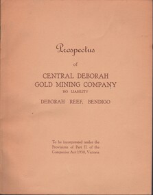
Document - MCCOLL, RANKIN AND STANISTREET COLLECTION: CENTRAL DEBORAH GOLD MINE NL: PROSPECTUS, 1939
... Victoria.' Details capital, proposed directors and manager. Contains map of Central and North Deborah mines and Monument Hill....Victoria.' Details capital, proposed directors and manager. Contains map of Central and North Deborah mines and Monument Hill. ...Document: McColl, Rankin & Stanistreet Collection: Central Deborah Gold Mine NL - 4 copies of prospectus. Buff covered booklet. Written on front ' Prospectus of Central Deborah Gold Mining Company No Liability Deborah Reef, Bendigo. To be incorporated under the Provisions of Part II of the companies Act 1938. Victoria.' Details capital, proposed directors and manager. Contains map of Central and North Deborah mines and Monument Hill.organization, business, central deborah gold mine, mccoll, rankin & stanistreet collection: central deborah gold mine nl. gold mining -
 Bendigo Historical Society Inc.
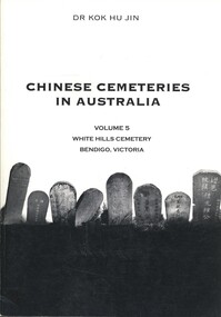
Book - CHINESE CEMETERIES IN AUSTRALIA VOLUME 5, c
... Hills Cemetery Bendigo, Victoria. Publisher: Golden Dragon Museum, Bendigo. ISBN: 09578013 7 8. 191 PAGES. Black and white illustrations & maps. ...Hills Cemetery Bendigo, Victoria. Publisher: Golden Dragon Museum, Bendigo. ISBN: 09578013 7 8. 191 PAGES. Black and white illustrations & maps. ...Chinese Cemeteries in Australia Volume 5, White Hills Cemetery Bendigo, Victoria. Publisher: Golden Dragon Museum, Bendigo. ISBN: 09578013 7 8. 191 PAGES. Black and white illustrations & maps. Published post 12 July 2003. Inscriptions $30.Dr Kok Hu Jinaustralia, history, chinese, white hills cemetery, chinese graves, genealogy -
 Bendigo Historical Society Inc.
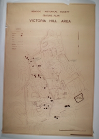
Map - VICTORIA HILL AREA, May 1971
... MAP...Bendigo...mining plan...Victoria Hill...Compiled by AHQ Survey Regiment, CMF Increment ( number 181 in Map Cupboard 1) Map VICTORIA HILL AREA ...Map: Bendigo Historical Society feature plan. There are 3 of these plans, one is without feature names and one has several places highlighted in pencil. Compiled by AHQ Survey Regiment, CMF Increment ( number 181 in Map Cupboard 1)map, bendigo, mining plan, victoria hill, bendigo historical society, conrad heinze butchers -
 Bendigo Historical Society Inc.
Document - MCCOLL, RANKIN AND STANISTREET COLLECTION: BENDIGO EXTENDED GOLD MINING COMPANY N/L MINING LEASE, 13 November 1956
... Map shows area running roughly parallel to Adam Street, Quarry Hill. Lease between Bendigo Extended Gild Mining Co. N/L and State of Victoria...Map shows area running roughly parallel to Adam Street, Quarry Hill. Lease between Bendigo Extended Gild Mining Co. N/L and State of Victoria ...Document: Bendigo Extended Gold Mining Company gold mining lease. 4 page document with attached map. Map shows area running roughly parallel to Adam Street, Quarry Hill. Lease between Bendigo Extended Gild Mining Co. N/L and State of Victoria. No. 11328, Vol 334 Fol 047.organization, mining, gold mining lease, bendigo extended gold mining co n/l; gold mining lease -
 Bendigo Historical Society Inc.
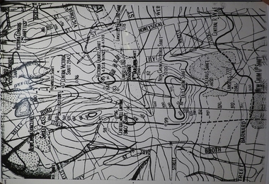
Map - MINING PLAN ,VICTORIA HILL AREA, No date visible
... MAP...Bendigo...mining plan...Mining... Gold Mines... Victoria Hill...Map: Large scale plan of an area of the Goldfield, Northward from Barnard Street, covering the Victoria Hill area. ...History House 11 Mackenzie Street Bendigo goldfields MAP Bendigo mining plan Mining Gold Mines Victoria Hill Lines of Reef Map: Large scale plan of an area of the Goldfield, Northward from Barnard Street, covering the Victoria Hill area. ...Map: Large scale plan of an area of the Goldfield, Northward from Barnard Street, covering the Victoria Hill area. Black printing on polycarbonate film. Transparent.map, bendigo, mining plan, mining, gold mines, victoria hill, lines of reef -
Bendigo Historical Society Inc.
Map - BIG 180 SHAFT POSITION, No date visible
... MAP...Bendigo...mining plan...Mining ... Gold Mines. Victoria Hill...Map: Plan showing the location of various shafts in the Victoria Hill area, hand draughted in pencil. ...History House 11 Mackenzie Street Bendigo goldfields MAP Bendigo mining plan Mining Gold Mines. Victoria Hill Big 180 Map: Plan showing the location of various shafts in the Victoria Hill area, hand draughted in pencil. ...Map: Plan showing the location of various shafts in the Victoria Hill area, hand draughted in pencil. Scale 2 Chains to 1 inchmap, bendigo, mining plan, mining , gold mines. victoria hill, big 180 -
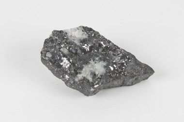
 The Beechworth Burke Museum
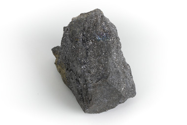
Geological specimen - Galena Chalcopyrite, Unknown
... Victoria that begun in 1852 (in response to the Gold Rush) to study and map the geology of Victoria. Collecting geological specimens was an important part of mapping and understanding the scientific makeup of the earth. Many of these specimens were sent to research and collecting organisations across Australia, including the Burke Museum, to educate and encourage further study. burke museum beechworth geological geological specimen galena galena chalcopyrite chalcopyrite broken hill bhp bhp mining broken hill mine mine australia mine lead lead mine A grey, solid hand-sized lead sulfide mineral with a silver metallic luster. ...Galena Chalcopyrite is the earth's primary ore of lead and is mined from a large number of deposits in many countries. It is also an important source of silver. Galena Chalcopyrite is one of the most abundant and widely distributed sulfide minerals across the world. The mineral is found in igneous and metamorphic rocks in medium- to low-temperature hydrothermal veins. This specific specimen was recovered from the mines in Broken Hill, New South Wales. The mines in Broken Hill were first established after Charles Rasp discovered a large amount of silver-lead-zinc ore-body in the area in 1883. BHP (Broken Hill Proprietary) mining company was then established in 1885 and quickly became the lead in Australia's mining industry after they began excavating and exporting the country's largest amount of lead, silver, and zinc. This feat generated over $100 billion in wealth for the company.Galena Chalcopyrite is signifiant as it represents the catalyst for the rise of Australia's most influential mining companies - BHP. The mineral was one of the first to be mined in the country and after being made into lead, was used for a variety of things such as paint, batteries, ammunition, and plumbing materials before it was known to be harmful to humans. This specimen is part of a larger collection of geological and mineral specimens collected from around Australia (and some parts of the world) and donated to the Burke Museum between 1868-1880. A large percentage of these specimens were collected in Victoria as part of the Geological Survey of Victoria that begun in 1852 (in response to the Gold Rush) to study and map the geology of Victoria. Collecting geological specimens was an important part of mapping and understanding the scientific makeup of the earth. Many of these specimens were sent to research and collecting organisations across Australia, including the Burke Museum, to educate and encourage further study. A grey, solid hand-sized lead sulfide mineral with a silver metallic luster.burke museum, beechworth, geological, geological specimen, galena, galena chalcopyrite, chalcopyrite, broken hill, bhp, bhp mining, broken hill mine, mine, australia mine, lead, lead mine -
 The Beechworth Burke Museum
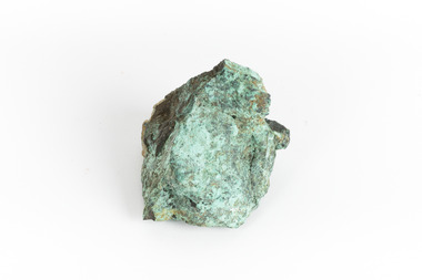
Geological specimen - Copper Ore
... Victoria that begun in 1852 (in response to the Gold Rush) to study and map the geology of Victoria. Collecting geological specimens was an important part of mapping and understanding the scientific makeup of the earth. Many of these specimens were sent to research and collecting organisations across Australia, including the Burke Museum, to educate and encourage further study. burke museum beechworth indigo shire beechworth musum geological geological specimen mineraology copper copper ore copper ore speciment broken hill new south wales A solid hand-sized cube-shaped sulfide and oxide with shades of green, grey and brown throughout. ...This specimen was recovered from Silverton Mine in Broken Hill, New South Wales. Otherwise known as the 'Day Dream Mine', the Silverton Mine was first established in 1883, when silver and lead deposits where discovered. Within a few short years, the population of Broken Hill reached 3000 people. As of today the Silverton Mine is still open, and has produced over 200 million tonnes of ore, which has generated over $100 billion. The Silverton Mine was also famous for a number of specimens such as silver, iron and zinc.Copper is considered to be a rare ore in that finding it in its pure form is rare. Nowadays when mining for Copper it is often found in mixed in with other minerals or it is recycled from use. Moreover, Copper is found in a range of everyday uses such as coins, cookware, pipes, heating conductors and anything that generate electricity. The fact that Copper is heat a heat conductor, electricity conductor and it does not corrode easily, makes this ore a versatile and useful. This specimen is part of a larger collection of geological and mineral specimens collected from around Australia (and some parts of the world) and donated to the Burke Museum between 1868-1880. A large percentage of these specimens were collected in Victoria as part of the Geological Survey of Victoria that begun in 1852 (in response to the Gold Rush) to study and map the geology of Victoria. Collecting geological specimens was an important part of mapping and understanding the scientific makeup of the earth. Many of these specimens were sent to research and collecting organisations across Australia, including the Burke Museum, to educate and encourage further study.A solid hand-sized cube-shaped sulfide and oxide with shades of green, grey and brown throughout. Copper is typically found as nuggets in the ground. It can be found in a range of forms such as its native state; mixed with other ores, such as zinc and iron; as porphyry copper deposits; and as major deposits. Porphyry deposits are when the mineral is scattered evenly throughout the rock. Major deposits are when the mineral is scattered amongst other minerals.burke museum, beechworth, indigo shire, beechworth musum, geological, geological specimen, mineraology, copper, copper ore, copper ore speciment, broken hill, new south wales -
 The Beechworth Burke Museum
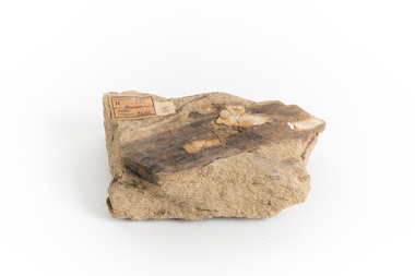
Geological specimen - Yellow Sandstone
... Victoria that begun in 1852 (in response to the Gold Rush) to study and map the geology of Victoria. Collecting geological specimens was an important part of mapping and understanding the scientific makeup of the earth. Many of these specimens were sent to research and collecting organisations across Australia, including the Burke Museum, to educate and encourage further study. burke museum beechworth indigo shire beechworth museum geological geological specimen mineralogy sandstone yellow sandstone victoria barefoot hills Geological survey / R.... ...This specimen is from Barefoot Hills, Victoria. Sandstones are economically important as major reservoirs for both petroleum and water, as building materials, and as valuable sources of metallic ores. Most significantly, they are the single most useful sedimentary rock type for deciphering Earth history. This specimen is part of a larger collection of geological and mineral specimens collected from around Australia (and some parts of the world) and donated to the Burke Museum between 1868-1880. A large percentage of these specimens were collected in Victoria as part of the Geological Survey of Victoria that begun in 1852 (in response to the Gold Rush) to study and map the geology of Victoria. Collecting geological specimens was an important part of mapping and understanding the scientific makeup of the earth. Many of these specimens were sent to research and collecting organisations across Australia, including the Burke Museum, to educate and encourage further study.A sedimentary rock composed mostly of quartz sand. Sandstone is the second most common sedimentary rock after shale. Sandstones consist of sand-sized grains principally quartz, feldspar and rock fragments. The two major classes of sandstone are arenite and wacke. the colour of sandstone varies from grey, yellow, red and white reflecting the variation in mineral content and cement and is gritty to touch (like sandpaper).Geological survey / R.... S 61 / Loc Bareboot Hills / Sheet / 24SE / 94 /burke museum, beechworth, indigo shire, beechworth museum, geological, geological specimen, mineralogy, sandstone, yellow sandstone, victoria, barefoot hills -
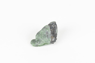
 The Beechworth Burke Museum
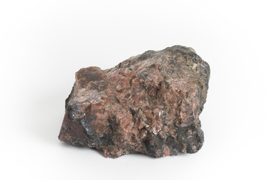
Geological specimen - Rhodonite with Galena and Sphalerite
... Victoria that begun in 1852 (in response to the Gold Rush) to study and map the geology of Victoria. Collecting geological specimens was an important part of mapping and understanding the scientific makeup of the earth. Many of these specimens were sent to research and collecting organisations across Australia, including the Burke Museum, to educate and encourage further study. burke museum beechworth geological geological specimen galena rhodonite sphalerite silver ore manganese lead sulphide lead ore zinc ore lapidary mineral specimen Broken Hill NSW A hand-sized piece of Sphalerite and Galena with Rhodonite crystals Geological specimen Rhodonite with Galena and Sphalerite ...This specimen is from Broken Hill, NSW. Galena is a natural mineral form of lead sulphide and is often found associated with sphalerite, calcite, and fluorite. Galena is an important lead ore mineral, and, in some regions, it is also an important mineral associated with silver ore. Sphalerite is a sulphide mineral that is the main ore of zinc. Rhodonite is an uncommon mineral once used as an ore of manganese in India, however today the scarcity and fragility of the crystals mean it is primarily used as lapidary materials or mineral specimens. In 1883, Charles Rasp who was a boundary rider at the time, discovered what he thought were deposits of tin but were in fact samples of silver and lead. He and six others went on to set up the first mining company in Broken Hill (BHP). The ore body became the largest and richest of its kind in the world mining ore worth more than 42,000 pounds in its first year. Many of these specimens were sent to research and collecting organisations across Australia, including the Burke Museum, to educate and encourage further study. Galena contains lead and silver, Sphalerite contains zinc. This specimen is part of a larger collection of geological and mineral specimens collected from around Australia (and some parts of the world) and donated to the Burke Museum between 1868-1880. A large percentage of these specimens were collected in Victoria as part of the Geological Survey of Victoria that begun in 1852 (in response to the Gold Rush) to study and map the geology of Victoria. Collecting geological specimens was an important part of mapping and understanding the scientific makeup of the earth. Many of these specimens were sent to research and collecting organisations across Australia, including the Burke Museum, to educate and encourage further study.A hand-sized piece of Sphalerite and Galena with Rhodonite crystalsburke museum, beechworth, geological, geological specimen, galena, rhodonite, sphalerite, silver ore, manganese, lead sulphide, lead ore, zinc ore, lapidary, mineral specimen, broken hill, nsw -
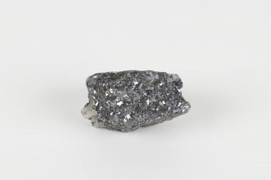
 The Beechworth Burke Museum
Geological specimen - Galena (with quartz), unknown
... Hill is one of the world’s most significant deposits of ore for the production of lead. This specimen is part of a larger collection of geological and mineral specimens collected from around Australia (and some parts of the world) and donated to the Burke Museum between 1868-1880. A large percentage of these specimens were collected in Victoria as part of the Geological Survey of Victoria that begun in 1852 (in response to the Gold Rush) to study and map ...Galena is the natural compound of lead and classed as a sulphide, it crystallises in a cubic pattern and its chemical formula is PbS. Galena is a primary source of both lead and silver. This specimen of Galena comes from Broken Hill. Broken Hill has one of the world’s largest and most significant deposit of ore for the production of lead. Mining of Galena at Broken Hill began with the staking of land by Charles Rasp in 1883. By the following year, in 1884, Rasp and six others had formed Broken Hill Mining Company. Broken Hill Mining Company eventually evolved into BHP group limited and is currently the largest mining company in the world and the largest company in Australia. There is archaeological evidence from artefacts discovered in Turkey that humans have been extracting lead from galena by the process of smelting since at least 6500 BCE. This specimen also has quartz on the top surface which is frequently discovered alongside Galena. This mineral specimen is of historic significance as a sample of Galena extracted from Broken Hill during the 19th century. Mining for Galena in Broken Hill begin in 1883 by Charles Rasp and evolved into the world’s largest mining company – BHP Group Limited. Broken Hill is one of the world’s most significant deposits of ore for the production of lead. This specimen is part of a larger collection of geological and mineral specimens collected from around Australia (and some parts of the world) and donated to the Burke Museum between 1868-1880. A large percentage of these specimens were collected in Victoria as part of the Geological Survey of Victoria that begun in 1852 (in response to the Gold Rush) to study and map the geology of Victoria. Collecting geological specimens was an important part of mapping and understanding the scientific makeup of the earth. Many of these specimens were sent to research and collecting organisations across Australia, including the Burke Museum, to educate and encourage further study.A flat, hand-sized, grey sulphide specimen that is the natural compound of lead with a quartz formation on the top surface. Existing Label: GALENA / (with quartz) / Locality: Broken Hill / N.S.W 120 x 70 x 29geological specimen, geology, geology collection, burke museum, beechworth, galena, galena quartz, quartz, charles rasp, broken hill mining company, bhp group limited, bhp, lead, ore, lead sulphide, sulphide, silver, broken hill -
 The Beechworth Burke Museum
Geological specimen - Galena (lead sulphide), Unknown
... Victoria that begun in 1852 (in response to the Gold Rush) to study and map the geology of Victoria. Collecting geological specimens was an important part of mapping and understanding the scientific makeup of the earth. Many of these specimens were sent to research and collecting organisations across Australia, including the Burke Museum, to educate and encourage further study. Geological Specimen geology Geology Collection Burke Museum Beechworth galena lead sulphide Alfred Selwyn Broken Hill ...Galena occurs in a range of deposit contexts, often in metalliferous veins, such as Broken Hill, Australia; Coeur d’Alene, Idaho, United States.; Clausthal Zellerfeld, Germany; and Cornwall, England. Large deposits also replace limestone, dolomite, or occasionally organic matter, or have a contact-metamorphic origin. Galena is additionally found in cavities, brecciated (fractured) zones in limestone and chert, and in coal beds. This specimen was recovered from Broken Hill NSW and is 60% lead with 8-12 oz/silver to the ton.Galena or 'lead glance' is a grey lead sulfide and the chief ore mineral of lead. It forms isometric crystals in which the ionic lattice is similar to sodium chloride. Galena is brittle and easily weathers to secondary lead minerals, with the upper part of mineral deposits often containing cerussite, anglesite, and pyromorphite. It usually contains silver, which is mined along with its lead content. Other commercially important minerals that form in close association with galena are antimony, copper, and zinc. This specimen is part of a larger collection of geological and mineral specimens collected from around Australia (and some parts of the world) and donated to the Burke Museum between 1868-1880. A large percentage of these specimens were collected in Victoria as part of the Geological Survey of Victoria that begun in 1852 (in response to the Gold Rush) to study and map the geology of Victoria. Collecting geological specimens was an important part of mapping and understanding the scientific makeup of the earth. Many of these specimens were sent to research and collecting organisations across Australia, including the Burke Museum, to educate and encourage further study.A small-sized solid specimen containing one mineral with a sparkly silver metallic lustre exterior and pastel-grey interior.geological specimen, geology, geology collection, burke museum, beechworth, galena, lead sulphide, alfred selwyn, broken hill -
 The Beechworth Burke Museum
Geological specimen - Green Feldspar (orthoclase)
... Victoria that begun in 1852 (in response to the Gold Rush) to study and map the geology of Victoria. Collecting geological specimens was an important part of mapping and understanding the scientific makeup of the earth. Many of these specimens were sent to research and collecting organisations across Australia, including the Burke Museum, to educate and encourage further study. Broken Hill ...Feldspar, derived from the German word feldspat, is a group of minerals which is the most common mineral group found on Earth, making up more than half of the planet's crust. The major rock-forming minerals in the Feldspar group include albite, anorthite, orthoclase and microcline. (Mindat, Feldspar Group). Orthoclase is part of the Feldspar Group subgroup, Alkaline Feldspar, which are known to be poor in calcium, and mostly rich in potassium. It is further also considered to be a K Feldspar, a subgroup of Alkaline Feldspar that are Potassium-dominant with variable crystal symmetry and Al-Si ordering state. Orthoclase are most commonly Colorless to white, Greenish white, Grayish yellow, or Pale pink and transparent to translucent with slightly pearly cleavage. The mineral rates at a 6 on the Mohs Hardness Scale. (cannot be scratched with a knife, but scratches glass with difficulty). The stronger green colour of this particular specimen is distinctive to the Broken Hill region (where it was found), and due to a small amount of lead. (BB) Its qualities find it misidentified at times as as microcline variety amazonite. Broken Hill is one of the world’s richest lead-zinc-silver deposits. The huge, 300-million-tonne orebody was discovered in 1883 and the superb mineral specimens attract collectors from around the world. (Australian Museum, Minerals from Australia: Australian mining regions)While feldspar is not by any means rare, this particular specimen has qualities distinctive to the Broken Hill mining district, with these properties leading at times to the mineral's misidentification. This creates potential for further study and identification of these mineral deposits through methods such as microscopic twinning, or using the position of certain d values in XRD patterns to calculate the degree of disorder of a K-feldspar, as discussed on the Mindat website (Mindat.com, Orthoclase:About Orthoclase). This specimen is part of a larger collection of geological and mineral specimens collected from around Australia (and some parts of the world) and donated to the Burke Museum between 1868-1880. A large percentage of these specimens were collected in Victoria as part of the Geological Survey of Victoria that begun in 1852 (in response to the Gold Rush) to study and map the geology of Victoria. Collecting geological specimens was an important part of mapping and understanding the scientific makeup of the earth. Many of these specimens were sent to research and collecting organisations across Australia, including the Burke Museum, to educate and encourage further study.A solid small aluminosilicate mineral composition which is primarily pale green and blue-grey in colour with traces of beige and white throughout. Note: green plumbian orthoclase (aka green feldspar) is an indicator mineral for the Broken Hill style lead-zinc deposits.N/Abroken hill mine, geological specimen, minerology -
Lorne Historical Society
Pamphlet - Tourist pamphlet Lorne, Lorne Victoria Australia
... Hill with two bathing suited young women in the foreground, and a blurb extolling the virtues of Lorne. On the back is a red, yellow and blue map of Lorne and district. Inside are eight black and white photographs of Lorne attractions,; the Main Street, tennis courts, Erskine River, walking tracks and the George River with the phrase ,” The resort that embraces everything for the perfect holiday.” Lorne Victoria ...Victorian Railways printed a series of brochures publicizing holiday destinations.A folded paper souvenir pamphlet. The cover is a colored picture of Lorne from Scotsman’s Hill with two bathing suited young women in the foreground, and a blurb extolling the virtues of Lorne. On the back is a red, yellow and blue map of Lorne and district. Inside are eight black and white photographs of Lorne attractions,; the Main Street, tennis courts, Erskine River, walking tracks and the George River with the phrase ,” The resort that embraces everything for the perfect holiday.”souvenirs, pamphlets, victorian railways,