Showing 96 items matching " wellington rd"
-
 Emerald Museum & Nobelius Heritage Park
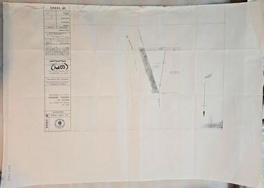
Map - Municipality Road classification - Wellington Rd. (section) 1978, Image of map indicating road classification alterations Wellington Rd. 1978, C1978
... Municipality Road classification - Wellington Rd. (section) 1978...Image of map indicating road classification alterations Wellington Rd. 1978...Map showing alterations to road classification Wellington Rd. Shire of Sherbrooke 1978...Title Survey Division/Crown Description/Part of Croan Allotment 104 Parish of Naree Worran County of Mornington/AMG reference 7922/55/358000/5798500/Municipality Road Classification/Shire of Sherbrooke Wellington Rd./Approved S.R. CLARKE, Principal Surveyor and Proper Officer 13.9.78/SP14820...Shire of Sherbrooke 1978 Image of map indicating road classification alterations Wellington Rd. 1978 Map Municipality Road classification - Wellington Rd. ...Map showing alterations to road classification Wellington Rd. Shire of Sherbrooke 1978Title Survey Division/Crown Description/Part of Croan Allotment 104 Parish of Naree Worran County of Mornington/AMG reference 7922/55/358000/5798500/Municipality Road Classification/Shire of Sherbrooke Wellington Rd./Approved S.R. CLARKE, Principal Surveyor and Proper Officer 13.9.78/SP14820 -
 Emerald Museum & Nobelius Heritage Park
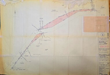
Map - Surveyors map of Wellington Rd. near Magpie Rd., Clematis, Part of Crown allotments 106E and 106G2, survey map of Wellington Rd., near Magpie Rd. 1972, c1972
... Surveyors map of Wellington Rd. near Magpie Rd., Clematis...Part of Crown allotments 106E and 106G2, survey map of Wellington Rd., near Magpie Rd. 1972...Image of Surveyors map outlining part of Wellington Rd., Near Magpie Rd., Clematis 1972...Gibson C/T 8047/414 subtract 0.01 1/2 for Title Image of Surveyors map outlining part of Wellington Rd., Near Magpie Rd., Clematis 1972 Part of Crown allotments 106E and 106G2, survey map of Wellington Rd., near Magpie Rd. 1972 Map Surveyors map of Wellington Rd. near Magpie Rd., Clematis ...Image of Surveyors map outlining part of Wellington Rd., Near Magpie Rd., Clematis 1972Title Survey Division/Crown Description/Part of Crown Allotments 106E and 106G2/Parish of Narree Worran, County of Mornington/Cardinia/Shire of Sherbrooke, Wellington Road/Rossley Paul Gardiner of Kirkpatrick & Webber, 289 Maroondah Hwy, Ringwood/Signed S.R. Clarke 21.6.72/B.A. Gibson C/T 8047/414 subtract 0.01 1/2 for Title -
 Emerald Museum & Nobelius Heritage Park
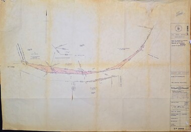
Map - Surveyors map of Wellington Rd. near Magpie Rd., and Paradise Rd., Clematis, Part of Crown allotments 106E and 106G2, survey map of Wellington Rd., near Magpie Rd. and Paradise Rd., Clematis 1972, c1972
... Surveyors map of Wellington Rd. near Magpie Rd., and Paradise Rd., Clematis...Part of Crown allotments 106E and 106G2, survey map of Wellington Rd., near Magpie Rd. and Paradise Rd., Clematis 1972...Image of Surveyors map outlining part of Wellington Rd., Near Magpie Rd. and Paradise Rd., Clematis 1972...Clarke 21.6.72 Image of Surveyors map outlining part of Wellington Rd., Near Magpie Rd. and Paradise Rd., Clematis 1972 Part of Crown allotments 106E and 106G2, survey map of Wellington Rd., near Magpie Rd. and Paradise Rd., Clematis 1972 Map Surveyors map of Wellington Rd. near Magpie Rd., and Paradise Rd., Clematis ...Image of Surveyors map outlining part of Wellington Rd., Near Magpie Rd. and Paradise Rd., Clematis 1972Title Survey Division/Crown Description/Part of Crown Allotments 106F2 and 106G1/Parish of Narree Worran, County of Mornington/Cardinia/Shire of Sherbrooke, Wellington Road/Rossley Paul Gardiner of Kirkpatrick & Webber, 289 Maroondah Hwy, Ringwood/Signed S.R. Clarke 21.6.72 -
 Emerald Museum & Nobelius Heritage Park
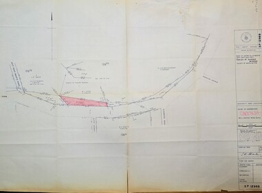
Map - Surveyors map of Wellington Rd. near Magpie Rd., and Paradise Rd., Clematis, Part of Crown allotments 106F2 and 106G1, survey map of Wellington Rd., near Magpie Rd. and Paradise Rd., Clematis 1972, c1972
... Surveyors map of Wellington Rd. near Magpie Rd., and Paradise Rd., Clematis...Part of Crown allotments 106F2 and 106G1, survey map of Wellington Rd., near Magpie Rd. and Paradise Rd., Clematis 1972...Image of Surveyors map outlining part of Wellington Rd., Near Magpie Rd. and Paradise Rd., Clematis 1972...Clarke 21.6.72 Image of Surveyors map outlining part of Wellington Rd., Near Magpie Rd. and Paradise Rd., Clematis 1972 Part of Crown allotments 106F2 and 106G1, survey map of Wellington Rd., near Magpie Rd. and Paradise Rd., Clematis 1972 Map Surveyors map of Wellington Rd. near Magpie Rd., and Paradise Rd., Clematis ...Image of Surveyors map outlining part of Wellington Rd., Near Magpie Rd. and Paradise Rd., Clematis 1972Title Survey Division/Crown Description/Part of Crown Allotments 106F2 and 106G1/Parish of Narree Worran, County of Mornington/Cardinia/Shire of Sherbrooke, Wellington Road/Rossley Paul Gardiner of Kirkpatrick & Webber, 289 Maroondah Hwy, Ringwood/Signed S.R. Clarke 21.6.72 -
 Emerald Museum & Nobelius Heritage Park
Map - Municipality Road Classification - Wellington Rd. (part) - Near Kitty Street, Crown Survey map - Crown allotments 106F2 & 106 G1 - Wellington Rd. near Kitty Street, c1972
... Municipality Road Classification - Wellington Rd. (part) - Near Kitty Street...Crown Survey map - Crown allotments 106F2 & 106 G1 - Wellington Rd. near Kitty Street...CLARKE, Principal Title Survey Officer & Proper Officer 21.6.72 Image of Title survey - Part of Crown Allotments 106F2 and 106G1 - Wellington Road, Shire of Sherbrooke Crown Survey map - Crown allotments 106F2 & 106 G1 - Wellington Rd. near Kitty Street Map Municipality Road Classification - Wellington Rd. ...Image of Title survey - Part of Crown Allotments 106F2 and 106G1 - Wellington Road, Shire of Sherbrooke SP12969/Title Survey Division/Crown Description/Part of Crown Alloments 106F2, 106F3 and 106G1, Parish of Narree Worran, County of Mornington/Municipality Road Classification/Shire of Sherbrooke, Wellington Road/(signed) Rossley Paul Gardner of Kirkpatrick & Webber, 280 Maroondah Highway, Ringwood, 29th March 1972/(Signed) S.R. CLARKE, Principal Title Survey Officer & Proper Officer 21.6.72 -
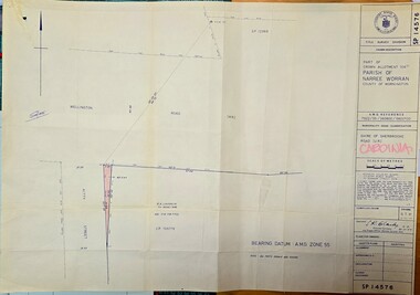 Emerald Museum & Nobelius Heritage Park
Map - Municipality Road Classification - Wellington Rd. (part), Crown Description - part of Crown Allotment 106 G1, Parish of Narree Worran, c1977
... Municipality Road Classification - Wellington Rd. (part)...Image of Title Survey, Part of Crown Allotment 106G1, Road Classification Shire of Sherbrooke Rd (Wellington Rd.)...CLARKE, Principal Surveyor and Proper Officer 21.11.77 Image of Title Survey, Part of Crown Allotment 106G1, Road Classification Shire of Sherbrooke Rd (Wellington Rd.) Crown Description - part of Crown Allotment 106 G1, Parish of Narree Worran Map Municipality Road Classification - Wellington Rd. ...Image of Title Survey, Part of Crown Allotment 106G1, Road Classification Shire of Sherbrooke Rd (Wellington Rd.)SP14576/Title Survey Division/Crown Description/Part of Crown Allotment 106 G1, Parish of Narree Worran, County of Mornington/AMG Reference 7922/55/360800/5800100/Municipality Road Classification/Shire of Sherbrooke Road/Kenneth Douglas Adams, Country Roads Board, 60 Denmark Street, Kew, Surveyor, dated 15th November, 1977/Approved S.R. CLARKE, Principal Surveyor and Proper Officer 21.11.77 -
 Mont De Lancey
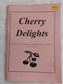
Book, Wandin and District Historical Museum Society, Cherry Delights: collection of recipes, Unknown
... Wellington Rd, Wandin , Victoria, Australia ...The 29 pages of recipes were contributed by the volunteers and friends of Mont De Lancey in Wandin.A small pink covered Cherry Delights recipe book with the title printed in black surrounded by a box and a few cherries drawn below. This is a collection of recipes in celebration of one of summer's favourite fruits, from Wandin's pioneers and country cooks. There is a Contents section at the back listing different types of recipes from main meals, puddings, deserts, cakes and more. There is an Acknowledgement on p.29 for the production of this publication. The back cover has Mont De Lancey Historical Home and Museum with the address. Pp. 31. non-fictionThe 29 pages of recipes were contributed by the volunteers and friends of Mont De Lancey in Wandin. cooking, cooking dishes, mont de lancey historical homestead, cookery books, fruit cooking -
Glenelg Shire Council Cultural Collection
Flyer - Flyer - Kurtze's Museum, n.d
... Flyer for Kurtze's Museum, 78 Wellington Rd Portland. White, black print, black and white photo of C.F. ...Glenelg Shire Council Cultural Collection History House Cliff Street Portland great-ocean-road Flyer for Kurtze's Museum, 78 Wellington Rd Portland. White, black print, black and white photo of C.F. ...Flyer for Kurtze's Museum, 78 Wellington Rd Portland. White, black print, black and white photo of C.F. Kurtze, proprietor -
 Melbourne Tram Museum
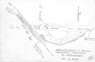
Drawing, Melbourne & Metropolitan Tramways Board (MMTB), "Modal Interchange Huntingdale Railway Station", 1973
... ... Wellington Rd...Melbourne Tram Museum 8 Wallen Road Hawthorn melbourne Trams tramways Huntingdale North Rd New Tramway Railways Wellington Rd Monash University Set of five foolscap sheets illustrating model interchange at Huntingdale Railway station to serve Monash University and further east. .1 - Photocopy of a sketch titled "Approximate layout of possible train tram interchange at Huntingdale" - dated 15/11/1973 Shows North Road, railway line, railway station and possible tram line. .2 - P14529 - Perspective of above, coloured, has figure 2 along the bottom edge. .3 - P14531 - sketch of a schematic layout at Huntingdale showing trains at either platform face along with a tram. ...Set of five foolscap sheets illustrating model interchange at Huntingdale Railway station to serve Monash University and further east. .1 - Photocopy of a sketch titled "Approximate layout of possible train tram interchange at Huntingdale" - dated 15/11/1973 Shows North Road, railway line, railway station and possible tram line. .2 - P14529 - Perspective of above, coloured, has figure 2 along the bottom edge. .3 - P14531 - sketch of a schematic layout at Huntingdale showing trains at either platform face along with a tram. Dated 7-12-1973. Has figure 2 along the bottom edge. .4 - P14545 - dated 11-11-74 - showing "Typical cross section Wellington Road for scheme D (Light rail)", showing the tramway in a trench possibly passing under Dandenong Road and other major intersections. has figure 8 along the bottom edge. .5 - P14523, dated 11-12-73 - showing a proposed loop into Monash University. Shows an extension to Ferntree Gully Station - See Reg Item 3807. Has figure 9 along the bottom edge.trams, tramways, huntingdale, north rd, new tramway, railways, wellington rd, monash university -
 Melbourne Tram Museum
Drawing, Melbourne & Metropolitan Tramways Board (MMTB), "Modal Interchange Huntingdale Railway Station", 1973
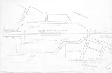
... ... Wellington Rd...Melbourne Tram Museum 8 Wallen Road Hawthorn melbourne Trams tramways Ferntree Gully New Tramway Railways Wellington Rd Monash University Set of four foolscap and folded sheets illustrating model interchange at the Ferntree Gully Railway station to serve Monash University and further west. .1 - Photocopy of a sketch titled "Approximate layout of possible train tram interchange at Ferntree Gully" - dated 16/11/1973 Shows North Road, railway line, railway station and possible tram line. .2 - P14532 - sketch of a schematic layout at Huntingdale showing trains at either platform face along with a tram. ...Set of four foolscap and folded sheets illustrating model interchange at the Ferntree Gully Railway station to serve Monash University and further west. .1 - Photocopy of a sketch titled "Approximate layout of possible train tram interchange at Ferntree Gully" - dated 16/11/1973 Shows North Road, railway line, railway station and possible tram line. .2 - P14532 - sketch of a schematic layout at Huntingdale showing trains at either platform face along with a tram. Dated 11-12-1973. Has figure 10 along the bottom edge. .3 - P14536 - dated Dec. 1973, showing a possible route to Modal Interchange at Ferntree Gully railway station using Forest Road. .4 - P14537 - ditto, but using Station St. See Reg Item 3806 for sketches at the Huntingdale Railway Station and Monash University.trams, tramways, ferntree gully, new tramway, railways, wellington rd, monash university -
 Southern Sherbrooke Historical Society Inc.
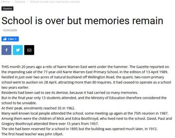
Ephemera - Narre Warren East School
... The school building on Wellington Rd, Narre Warren East now functions as a childcare centre....The school building on Wellington Rd, Narre Warren East now functions as a childcare centre. ...Narre Warren East School operated from 1912 to 1987. The school building on Wellington Rd, Narre Warren East now functions as a childcare centre. -
 Southern Sherbrooke Historical Society Inc.
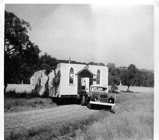
Photograph, Narre Warren Methodist Church being relocated in 1968
... Black and white photo showing the Narre Warren East Methodist Church in 1968 being backed onto a block on the north side of Wellington Rd near the intersection with (now) Edebohls Rd. ...Photo copied from Edna Boothroyd whose family lived on Wellington Rd, Narre Warren East. Also mud map showing where the church was moved from and to. ...Black and white photo showing the Narre Warren East Methodist Church in 1968 being backed onto a block on the north side of Wellington Rd near the intersection with (now) Edebohls Rd. It was moved from a site closer to Kerrs Park. Photo copied from Edna Boothroyd whose family lived on Wellington Rd, Narre Warren East. Also mud map showing where the church was moved from and to. -
Glenelg Shire Council Cultural Collection
Photograph - Photograph - Railway Construction, Port of Portland, n.d
... Portland Harbour Trust railway line in foreground. Wellington Rd/ Cliff St; Gardens tennis courts and clubhouse, Botanical gardens with lifeboat shelter, at rear....Portland Harbour Trust railway line in foreground. Wellington Rd/ Cliff St; Gardens tennis courts and clubhouse, Botanical gardens with lifeboat shelter, at rear. ...Port of Portland Authority Archivesport of portland archives, portland harbour trust, portland lifeboat, botanical gardens -
Glenelg Shire Council Cultural Collection
Photograph - Photograph - oil tanks, n.d
... Black and white photograph showing shell oil tanks, west side of Wellington Rd. Photo taken from Fishermans breakwater area, Satcol on left, bridge over canal in front of tanks....Glenelg Shire Council Cultural Collection History House Cliff Street Portland great-ocean-road Port of Portland Authority Archives Port of Portland Archives oil tanks Back: 2398 Lines drawn in biro 5 3/4" 4 1/8" 8036 s/s in pencil Black and white photograph showing shell oil tanks, west side of Wellington Rd. Photo taken from Fishermans breakwater area, Satcol on left, bridge over canal in front of tanks. ...Port of Portland Authority ArchivesBack: 2398 Lines drawn in biro 5 3/4" 4 1/8" 8036 s/s in pencilport of portland archives, oil tanks -
 Mont De Lancey
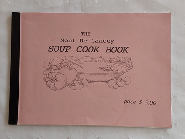
Book, Marie Colling, The Mont De Lancey Soup Cook Book, Unknown
... On the back cover: 'Complied and printed by Marie Colling for Mont De Lancey Wellington Rd Wandin 3139'...On the back cover: 'Complied and printed by Marie Colling for Mont De Lancey Wellington Rd Wandin 3139' A small rectangular pink covered home made Soup Cook Book printed with the title, an illustration of a bowl of soup with vegetables around it, and the price $5.00 in the lower right hand corner. ...A simple soup recipe book compiled by a local resident of the area, Marie Colling for sale at Mont De Lancey Historical Homestead which may be purchased along with other items of interest at the reception desk and small shop area.A small rectangular pink covered home made Soup Cook Book printed with the title, an illustration of a bowl of soup with vegetables around it, and the price $5.00 in the lower right hand corner. Inside are a large variety of soup recipes, including ones that can be made in a microwave. The back cover has compilation details for Mont De Lancey. It is stapled together and bound at the spine with black tape. Pp.40.non-fictionA simple soup recipe book compiled by a local resident of the area, Marie Colling for sale at Mont De Lancey Historical Homestead which may be purchased along with other items of interest at the reception desk and small shop area.cooking, soup cooking, cookery books -
 Glenelg Shire Council Cultural Collection
Photograph - Photograph - Portland, n.d
... Black & White photo taken from the bottom of Wellington Rd. looking across the harbour. Bridge across Salt Creek in foreground; Botanic gardens on left; Fisherman's Breakwater right; Railway Pier: Ocean Pier; Bentinck Street in background....Glenelg Shire Council Cultural Collection History House Cliff Street Portland great-ocean-road Con Kroker Collection Black & White photo taken from the bottom of Wellington Rd. looking across the harbour. Bridge across Salt Creek in foreground; Botanic gardens on left; Fisherman's Breakwater right; Railway Pier: Ocean Pier; Bentinck Street in background. ...Con Kroker Collection -
Glenelg Shire Council Cultural Collection
Negative - Negative - Portland Museum, Victoria, c. 1934
... NEGATIVE FOR BLACK AND WHITE PHOTOGRAPH Portland museum east side of Wellington Rd. Wooden building, iron roof, whale bones on verandah and in garden. ...Glenelg Shire Council Cultural Collection History House Cliff Street Portland great-ocean-road negative Portland Gordon Hotel building construction museum NEGATIVE FOR BLACK AND WHITE PHOTOGRAPH Portland museum east side of Wellington Rd. Wooden building, iron roof, whale bones on verandah and in garden. ...NEGATIVE FOR BLACK AND WHITE PHOTOGRAPH Portland museum east side of Wellington Rd. Wooden building, iron roof, whale bones on verandah and in garden. Woman standing on veranda. Building one of original buildings of hotel where current Gordon Hotel is.negative, portland, gordon hotel, building, construction, museum -
Glenelg Shire Council Cultural Collection
Financial record - Catalogue - Auction items, c. 1976
... Twenty-three page catalogue for the auction of antique furniture, Victoriana china, silver, bric-a-brac, etc. at 'Stanton Drew' 89 Wellington Rd. Portland, on Mon. 15th March, 1976. ...Glenelg Shire Council Cultural Collection History House Cliff Street Portland great-ocean-road Twenty-three page catalogue for the auction of antique furniture, Victoriana china, silver, bric-a-brac, etc. at 'Stanton Drew' 89 Wellington Rd. Portland, on Mon. 15th March, 1976. ...Twenty-three page catalogue for the auction of antique furniture, Victoriana china, silver, bric-a-brac, etc. at 'Stanton Drew' 89 Wellington Rd. Portland, on Mon. 15th March, 1976. Covers glossy paper, light burgundy and white, photo of 'Stanton Drew'. White glossy pages, burgundy print. -
Southern Sherbrooke Historical Society Inc.
Photograph - Set of photos of official opening of works at Cardinia Reservoir, May 1970
... The photos were taken by Edna or Mick Boothroyd of Wellington Rd, Narre Warren East and were brought by Edna to the first display of the Southern Sherbrooke Historical Society on 20th June 1993....The photos were taken by Edna or Mick Boothroyd of Wellington Rd, Narre Warren East and were brought by Edna to the first display of the Southern Sherbrooke Historical Society on 20th June 1993. ...A set of four black and white photos of the official opening of works at Cardinia Reservoir, Narre Warren East, May 1970. The photos were taken by Edna or Mick Boothroyd of Wellington Rd, Narre Warren East and were brought by Edna to the first display of the Southern Sherbrooke Historical Society on 20th June 1993. -
 Southern Sherbrooke Historical Society Inc.
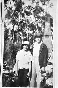
Photograph - Bill Slingo Senior and Junior by tin chimney, 1937
... The Slingos lived on Wellington Rd, Narre Warren East. ...The Slingos lived on Wellington Rd, Narre Warren East. Photograph Bill Slingo Senior and Junior by tin chimney, 1937. ...Photo shows a man dressed in pale trousers, an open-necked shirt, a blazer and a peaked cap. He is with a boy dressed in dark pants, a pale, short-sleeved shirt and a narrow-brimmed sunhat. A tin chimney narrowing towards the top is behind them. There are hydrangea bushes nearby and tall trees in the background. The Slingos lived on Wellington Rd, Narre Warren East. -
 Southern Sherbrooke Historical Society Inc.
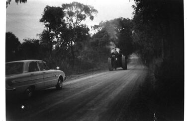
Photograph - Steam-driven tractor on Duffys Rd, Narre Warren East
... Photo copied from Edna Boothroyd whose family lived on Wellington Rd, Narre Warren East. ...Photo copied from Edna Boothroyd whose family lived on Wellington Rd, Narre Warren East. Photograph Steam-driven tractor on Duffys Rd, Narre Warren East. ...Black and white photo of a steam-driven tractor being driven down Duffys Rd, Narre Warren East. Steam is rising about the tractor. There is at least one other person on the tractor apart from the driver, possibly a woman and a boy. The driver lived further down Duffys Rd. His house was moved prior to work beginning on the Cardinia Reservoir. A sedan is driving behind the tractor. Photo copied from Edna Boothroyd whose family lived on Wellington Rd, Narre Warren East. -
 Melbourne Tram Museum
Document - Folder of Track crossections drawings, Melbourne & Metropolitan Tramways Board (MMTB), c1928
... The folder is marked "H Bell" most likely the son of the later Chairman, Mr Hector Bell who was a civil engineer with the MMTB. 1 - P3948 - Camberwell Road - 1926 2 - P2789 - Camberwell Road reconstruction - 1920 3 - P3753 - Chapel St - 1926 4 - P60 - Expansion joints Church St bridge - 1924 5 - P3686 - Commercial Road reconstruction - 1926 6 - P4024 - Cotham Road reconstruction - 1927 7 - P4699 - Droop St duplication - 1927 8 - P2384 - Flemington Road conversion - 1925 9 - P1187 - Flemington Road tramway - undated c1920 10 - P4131 - Flinders St conversion - 1927 11 - P4132 - Flinders St conversion - special track drains where subject to flooding - 1927 12 - P3603 - Glenferrie Road east track - 1926 13 - P2608 - Glenferrie Road reconstruction - 1925 14 - P3577 - Glen Huntly Road extension - 1926 15 - P3745 - Glen Huntly Rd duplication - 1926 16 - P4655 - Gilbert Rd duplication - 1928 17 - P2472 - Hannah St at Crossings 1925 18 - P2459 - Hannah St in plantations - 1925 19 - P2582 - High St Prahran reconstruction - 1926 20 - P1594 - High St Prahran reconstruction - 1925 21 - P3611 - High St Malvern reconstruction - 1926 22 - P3900 - Lygon St - 1926 23 - P3689 - Malvern Road reconstruction - 1926 24 - P3951 - West Coburg Route - sleeper spacing - 1926 25 - P4703 - Nicholson St Coburg - duplication - 1928 26 - P4470 - Norwood Road duplication - 1927 27 - P2473 - Park St tramway - 1925 28 - P3707 - Riversdale Road reconstruction - 1926 29 - P4630 - Riversdale Road extension - 1927 30 - P4497- Riversdale Road duplication - 1927 31 - P1387 - South Melbourne Road - special boxed in Construction for Albert Road (parking loop) - 1924 32 - P4691 - Swan St reconstruction - 1927 33 - P3640 - Victoria St part - 1926 (2 copies) 34 - P4522 - Wallen Road reconstruction - 1927 35 - P3939 - Wallen Road reconstruction in front of depot - 1927 36 - P4702 - Trial types of track - 1928 37 - P4254 - Wattletree Road reconstruction - 1927 38 - P4531 - Wattletree Road connection to Glenferrie Road - 1927 39 - P4708 - Wellington Rd siding - 1928...The folder is marked "H Bell" most likely the son of the later Chairman, Mr Hector Bell who was a civil engineer with the MMTB. 1 - P3948 - Camberwell Road - 1926 2 - P2789 - Camberwell Road reconstruction - 1920 3 - P3753 - Chapel St - 1926 4 - P60 - Expansion joints Church St bridge - 1924 5 - P3686 - Commercial Road reconstruction - 1926 6 - P4024 - Cotham Road reconstruction - 1927 7 - P4699 - Droop St duplication - 1927 8 - P2384 - Flemington Road conversion - 1925 9 - P1187 - Flemington Road tramway - undated c1920 10 - P4131 - Flinders St conversion - 1927 11 - P4132 - Flinders St conversion - special track drains where subject to flooding - 1927 12 - P3603 - Glenferrie Road east track - 1926 13 - P2608 - Glenferrie Road reconstruction - 1925 14 - P3577 - Glen Huntly Road extension - 1926 15 - P3745 - Glen Huntly Rd duplication - 1926 16 - P4655 - Gilbert Rd duplication - 1928 17 - P2472 - Hannah St at Crossings 1925 18 - P2459 - Hannah St in plantations - 1925 19 - P2582 - High St Prahran reconstruction - 1926 20 - P1594 - High St Prahran reconstruction - 1925 21 - P3611 - High St Malvern reconstruction - 1926 22 - P3900 - Lygon St - 1926 23 - P3689 - Malvern Road reconstruction - 1926 24 - P3951 - West Coburg Route - sleeper spacing - 1926 25 - P4703 - Nicholson St Coburg - duplication - 1928 26 - P4470 - Norwood Road duplication - 1927 27 - P2473 - Park St tramway - 1925 28 - P3707 - Riversdale Road reconstruction - 1926 29 - P4630 - Riversdale Road extension - 1927 30 - P4497- Riversdale Road duplication - 1927 31 - P1387 - South Melbourne Road - special boxed in Construction for Albert Road (parking loop) - 1924 32 - P4691 - Swan St reconstruction - 1927 33 - P3640 - Victoria St part - 1926 (2 copies) 34 - P4522 - Wallen Road reconstruction - 1927 35 - P3939 - Wallen Road reconstruction in front of depot - 1927 36 - P4702 - Trial types of track - 1928 37 - P4254 - Wattletree Road reconstruction - 1927 38 - P4531 - Wattletree Road connection to Glenferrie Road - 1927 39 - P4708 - Wellington Rd siding - 1928 Yields information about the various tramway track cross sections used by the MMTB including cable tram conversions. tramways MMTB Tram tracks rails civil engineering cable conversion new tramways Has "H Bell" in ink on rear cover. ...The document provides cross sections of track used from c1920 to 1928. The folder is marked "H Bell" most likely the son of the later Chairman, Mr Hector Bell who was a civil engineer with the MMTB. 1 - P3948 - Camberwell Road - 1926 2 - P2789 - Camberwell Road reconstruction - 1920 3 - P3753 - Chapel St - 1926 4 - P60 - Expansion joints Church St bridge - 1924 5 - P3686 - Commercial Road reconstruction - 1926 6 - P4024 - Cotham Road reconstruction - 1927 7 - P4699 - Droop St duplication - 1927 8 - P2384 - Flemington Road conversion - 1925 9 - P1187 - Flemington Road tramway - undated c1920 10 - P4131 - Flinders St conversion - 1927 11 - P4132 - Flinders St conversion - special track drains where subject to flooding - 1927 12 - P3603 - Glenferrie Road east track - 1926 13 - P2608 - Glenferrie Road reconstruction - 1925 14 - P3577 - Glen Huntly Road extension - 1926 15 - P3745 - Glen Huntly Rd duplication - 1926 16 - P4655 - Gilbert Rd duplication - 1928 17 - P2472 - Hannah St at Crossings 1925 18 - P2459 - Hannah St in plantations - 1925 19 - P2582 - High St Prahran reconstruction - 1926 20 - P1594 - High St Prahran reconstruction - 1925 21 - P3611 - High St Malvern reconstruction - 1926 22 - P3900 - Lygon St - 1926 23 - P3689 - Malvern Road reconstruction - 1926 24 - P3951 - West Coburg Route - sleeper spacing - 1926 25 - P4703 - Nicholson St Coburg - duplication - 1928 26 - P4470 - Norwood Road duplication - 1927 27 - P2473 - Park St tramway - 1925 28 - P3707 - Riversdale Road reconstruction - 1926 29 - P4630 - Riversdale Road extension - 1927 30 - P4497- Riversdale Road duplication - 1927 31 - P1387 - South Melbourne Road - special boxed in Construction for Albert Road (parking loop) - 1924 32 - P4691 - Swan St reconstruction - 1927 33 - P3640 - Victoria St part - 1926 (2 copies) 34 - P4522 - Wallen Road reconstruction - 1927 35 - P3939 - Wallen Road reconstruction in front of depot - 1927 36 - P4702 - Trial types of track - 1928 37 - P4254 - Wattletree Road reconstruction - 1927 38 - P4531 - Wattletree Road connection to Glenferrie Road - 1927 39 - P4708 - Wellington Rd siding - 1928Yields information about the various tramway track cross sections used by the MMTB including cable tram conversions.Folder - heavy card cloth covers fitted with two interscrews containing some 39 plus one duplicate folded blue prints. Covers made by Swinnerton Bros of Melbourne - see image 6 for their logo/trademark.Has "H Bell" in ink on rear cover.tramways, mmtb, tram tracks, rails, civil engineering, cable conversion, new tramways -
 Bendigo Military Museum
Postcard - POSTCARD, ALDERSHOT, UK, Valentine's Series, c 1914 - 1918
... Wellington Monumental, Aldershot. Handwritten on back in black ink: 'I was right up around this place!' 8. Municipal Gardens, Aldershot. Handwritten on back in black ink: 'This place is very pretty, Bob'. 9. Cambridge Hospital, Aldershot. Handwritten on back in black ink "This is a fine place!". 10. Hospital Hill, Aldershot. 11. Smith Dorrien Home, Aldershot. Handwritten on back in black ink. 'I was all over Aldershot with Uncle. I have saw all these places. Bob.' 12. R.A.M.C. Memorial, Aldershot. 13. Victoria Rd...Wellington Monumental, Aldershot. Handwritten on back in black ink: 'I was right up around this place!' 8. Municipal Gardens, Aldershot. Handwritten on back in black ink: 'This place is very pretty, Bob'. 9. Cambridge Hospital, Aldershot. Handwritten on back in black ink "This is a fine place!". 10. Hospital Hill, Aldershot. 11. Smith Dorrien Home, Aldershot. Handwritten on back in black ink. 'I was all over Aldershot with Uncle. I have saw all these places. Bob.' 12. R.A.M.C. Memorial, Aldershot. 13. Victoria Rd ...R..H. Baron took leave from Herdcott Camp between 4.10.19918 and 8.10.1918 to visit Aldershot. See Catalogue No. 7743 for leave pass details. Relatives lived in the Aldershot area. Part of the 'Robert H. Baron', No.3596 and Cooper Collections. See Catalogue No. 19819 for details of Baron's service.1. Coloured street scene with buildings, groups of people and horse drawn transport. 2. Coloured street scene with buildings, groups of people and horse drawn transport. 3. Coloured street scene with buildings, groups of people. 4. Coloured scene features a canal with boat, tow path, bridge and house. 5. Coloured, Band marching down a street. Spectators lining the road. Church in background. 6. Coloured Group of soldiers in uniform marching along the road. Spectators, church in background. 7. Coloured statue of a man on a horse. Statue located on a hill 8. Coloured scene of gardens surrounded by buildings and a church. Groups of women. 9. Coloured - Large building with a clock tower. 10. Coloured column of uniformed soldiers on horseback. Buildings lining road. Horse drawn transport sharing road. 11. Coloured street scene with red brick building and pedestrians. 12. Coloured Monument with inscription. Buildings in background. 13. Black and wgite street scene. Street lined with buildings. Horse drawn transport. Pedestrians.1. High Street, Aldershot. 2. Wellington Street, Aldershot. 3. Union Street, Aldershot. Handwritten in black ink on back: (Notice how narrow the streets are). 4. Wharf Bridge, Farnborough Road, Aldershot. Handwritten in black ink on back: "I was all over these places with Uncle. I had a good time in Aldershot, Bob. 5. Wellington Avenue (Church Parade), Aldershot. Handwritten in black ink: 'One of the Aldershot bands', R.H. Baron.' 6. Queens Avenue and St. George's Church, Aldershot. Handwritten in black ink on back: 'Soldiers going to church". 7. Wellington Monumental, Aldershot. Handwritten on back in black ink: 'I was right up around this place!' 8. Municipal Gardens, Aldershot. Handwritten on back in black ink: 'This place is very pretty, Bob'. 9. Cambridge Hospital, Aldershot. Handwritten on back in black ink "This is a fine place!". 10. Hospital Hill, Aldershot. 11. Smith Dorrien Home, Aldershot. Handwritten on back in black ink. 'I was all over Aldershot with Uncle. I have saw all these places. Bob.' 12. R.A.M.C. Memorial, Aldershot. 13. Victoria Rd, Aldershot.robert h. baron, cooper collection, aldershot uk, postcards -
 Eltham District Historical Society Inc
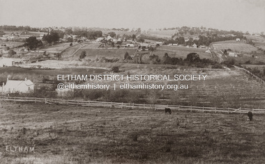
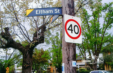
Photograph, Brougham Street, Eltham, early 1900s, 1900s
... Eltham District Historical Society Inc 728 Main Rd Eltham melbourne eltham brougham street wellington street susan street Colour photograph of a poor quality photograph (in album) of Brougham Street, Eltham looking east from near Susan Street, early 1900s Brougham Street, Eltham, early 1900s Photograph ...Colour photograph of a poor quality photograph (in album) of Brougham Street, Eltham looking east from near Susan Street, early 1900seltham, brougham street, wellington street, susan street -
Glen Eira Historical Society
Book - Nathan, Bertram
... Rd Caulfield VIC 3162 melbourne This site comprises of the entry for Bertran Nathan in the publication ‘500 Victorians Centenary Edition 1934 [page 215]’. The entry consists of a cartoon figure of Mr.Nathan with a superimposed photograph of his head together with sketches illustrating his interest. Below the cartoon is a modified ‘who’s who entry for Mr.Nathan with his occupation academic qualification, date of birth, schooling details, address, club membership, hobbies and recreational interests. Celebrations Optician Wellington ...This site comprises of the entry for Bertran Nathan in the publication ‘500 Victorians Centenary Edition 1934 [page 215]’. The entry consists of a cartoon figure of Mr.Nathan with a superimposed photograph of his head together with sketches illustrating his interest. Below the cartoon is a modified ‘who’s who entry for Mr.Nathan with his occupation academic qualification, date of birth, schooling details, address, club membership, hobbies and recreational interests.celebrations, optician, wellington college[nz], 500 victorians centenary edition 1934, nathan bertram, legacy club, education, sports and recreations, occupations, secondary education, stamp collecting, health professional, wesley college, angling, golfers -
 Eltham District Historical Society Inc
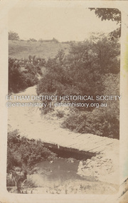
Postcard - Photograph postcard, Old Bridge, Kaylock's Crossing, Brougham Street, Eltham, c.1912
... Eltham District Historical Society Inc 728 Main Rd Eltham melbourne Date estimated to be circa 1912 based on the style of printing on the reverse of the card - Kodak Austral paper for real photo postcards, the paper was manufactured c.1908-1914 (See also POSTCARDS ON KODAK PAPER - IS IT POSSIBLE TO "DATE" THEM? http://tps.org.au/bb/viewtopic.php?t=115) Brougham Street was created in Josiah Holloway's 1851 subdivision of Little Eltham. It was one of several east-west streets shown on the subdivision plan as crossing the Diamond Creek. The western part was named Wellington ...Date estimated to be circa 1912 based on the style of printing on the reverse of the card - Kodak Austral paper for real photo postcards, the paper was manufactured c.1908-1914 (See also POSTCARDS ON KODAK PAPER - IS IT POSSIBLE TO "DATE" THEM? http://tps.org.au/bb/viewtopic.php?t=115) Brougham Street was created in Josiah Holloway's 1851 subdivision of Little Eltham. It was one of several east-west streets shown on the subdivision plan as crossing the Diamond Creek. The western part was named Wellington Street on the subdivision plan but was later changed to conform with the name of the eastern part as acknowledgement of the continuity of the street. It is not known when the first bridge was constructed in Brougham Street however it was certainly mentioned at Council’s meeting of 2 June 1884 as being in a dangerous state of repair. This photo (c.1895) of an old bridge shows a very low-level simple log girder bridge crossing the creek at a right angle and so the approaches involved bends in the road alignment. This bridge was generally known as Kaylocks Bridge or Kaylock’s Crossing after the owner of the adjoining land. It was most likely built from around the mid-1850s, or a crossing of some fashion established as Richard George Kaylock, butcher of Little Eltham and his wife Emily Ann settled there in 1854. His property was in Wellington Street (now Brougham Street) and apparently extended across the Diamond Creek. The land on the western side of the creek was farmed, the house being on the eastern side. Kaylock's Bridge formed part of the original coach road to Eltham and in 1922 was described as an "old rustic bridge". Its low level and insubstantial construction made it susceptible to flood damage, necessitating frequent closures until repairs could be carried out. In September 1922, Council called for tenders for a new timber bridge to be constructed at Kaylock’s crossing. An engineering assessment carried out for the Council by Macleod Consulting at the time of the replacement suggested that the construction details indicate that it was in the 1900s, however this dating could possibly have been the result of numerous repairs undertaken over the years to flood damage. The tender was awarded to Mr Weller of Kangaroo Ground who commenced work in February 1923 on a higher-level timber trestle bridge. Work was slowed due to illness of the contractor and the accidental death of a man in March 1923 following the collapse of the bank after he had jumped into a hole that had just been blasted. The bridge was completed around July 1923 at which point the old structure was pulled up, marking what was described in the ‘Advertiser’ newspaper as the passing of an old and well-loved landmark in the district. In April 1924 the approach to Kaylocks bridge was washed away during the heavy flooding that destroyed the Main Road bridge. The western side was repaired, and an extra span was added to the eastern side using timber from the destroyed Main Road bridge. The bridge was again severely damaged four months later in August 1924 When a lack of finances delayed repairs to the Bridge Street bridge in 1931 (also referred to as Obelisk Bridge at the time), traffic had to detour via Brougham Street for some time. Local residents feared that the Bridge Street bridge might never reopen. Kaylocks Bridge was constantly subject to damage by floods. In the 1934 flood it was submerged by two feet of water. In more recent times the bridge was again severely damaged by flooding and repairs made. A new bridge and adjoining footbridge were constructed in 2009.Digital file only Postcards scanned from the collection of Michael Aitken on loan to EDHS, 2 Sep. 2022michael aitken collection, eltham, postcards, bridge, brougham street, diamond creek (creek), kaylocks bridge, wellington street -
 Eltham District Historical Society Inc
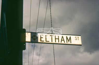
Slide - Photograph, Eltham Street, Flemington, c.1993
... Eltham District Historical Society Inc 728 Main Rd Eltham melbourne Eltham Street Flemington Wellington Street 35mm colour positive transparency Mount - Black and White Eltham Street, Flemington Slide Photograph ...35mm colour positive transparency Mount - Black and Whiteeltham street, flemington, wellington street -
 Eltham District Historical Society Inc
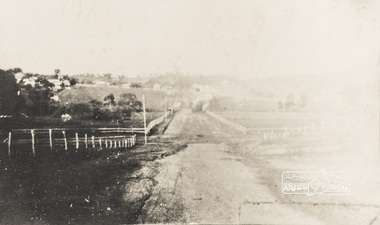
Photograph - Photograph postcard, J.H. Clark, Eltham (from Bolton Street), c.1915
... Eltham District Historical Society Inc 728 Main Rd Eltham melbourne Original sepia photo postcard of early view of Eltham looking east from Bolton Street between Bridge Street and Brougham Street (Wellington). ...Original sepia photo postcard of early view of Eltham looking east from Bolton Street between Bridge Street and Brougham Street (Wellington). Fenced road reserve on right is Brougham Street. Originally dated as pre-1877 introduction of the Telegraph (the Telegraph was connected to the Post Office on Thursday, June 7, 1877) given the lack of poles and wires visible, a more recent higher resolution scan has revealed more detail highlighting the presence of several Telegraph poles: one about half way between Brougham Street and Dalton Street, one opposite the Police Residence, another opposite W.B Andrew’s Corn Store (Zen Den site), one possibly near the Fountain/Evelyn Hotel. Also, given the photo was originally marked “J. H. Clark Photo” it is safer to assume the image is dated circa 1915 until dates of further image details can be confirmed. Photographer: J.H. Clark John Henry Clark was the youngest of three boys born to William Henry Clark (1823-1877) and Maria White (1843-1914). He and his brothers, William Charles Clark (1872-1945), Clement Kent Clark (1874-1912) operated a photography business (Clark Bros.) from 25 Thomas Street, Windsor near Prahran during the period c.1894 to 1914. Following death of Clement in September 1912 and their mother in 1914, the Clark Bros business appears to have dissolved, the premises demolished, and a new house was under construction in 1915. John set up business independently in 1914 operating out of 29 Moor Street, Fitzroy where he is registered in the 1914 and 1915 Electoral Rolls. By 1916 John had relocated to Eltham where he continued his practice as a photographer and took many of the early images around the district of Little Eltham. Around 1930 John changed professions and opened a small cobbler's shop in 1931 near the pond opposite Dalton Street adjacent to the Jarrold family cottage. He never married and continued his profession as a bootmaker from this little shop, maintaining a close relationship with Mrs Jarrold for the rest of their lives. His bootmaker shop remains today beside the Whitecloud cottage and is one of only three remaining shops in the area from the early 20th century. There are a couple of images of Eltham taken by Clark Bros. in the Eltham District Historical Society collection, one such example being Hunniford’s Post Office with Miss Anne Hunniford out front (EDHS_00140 - marked on the back of the print, Clark Bros., 25 Thomas St. Windsor), which would date this image between c.1894 and 1914. Other early images of Eltham taken by John Henry Clark are marked on the face “J. H. Clark Photo” and it is assumed these are dated between 1914 and 1930. It is noted that the Grant of Probate for John H Clark of Eltham South dated 5 April 1957 (513/387) records his occupation as "X Photographer".1. Original sepia postcard - water damaged lower left corner over approximate 30mm diameter destroying image and photohgrapher's markings (same as EDHS_00533 and EDHS_00535 - all from same donor collection) 2. A second black and white print copy of the same image from a different unknown source (of lower resolution quality) is also held. 3. A digital enhanced version has been created using the lower quality black and white print as a donor source for the damaged section of the postcard.In pencil on back of postcard: A. Petrie Verandah on Andrews shop Pearsons house (Living and Learning Centre)bolton street, brougham street, cafe zen den, courthouse, eltham courthouse, eltham hotel, eltham living and learning centre, eltham living and learning, eltham, fountain hotel, j.h. clark photo, knapmans forge, main road, maria street, pitt street, police residence, police station, post office, st margaret’s church, w.b. andrew corn store, wellington street, early eltham, little eltham -
 Eltham District Historical Society Inc
Photograph, Eltham Street and Wellington Road, Flemington
... Eltham District Historical Society Inc 728 Main Rd Eltham melbourne eltham street Colour photograph Eltham Street and Wellington Road, Flemington Photograph ...Colour photographeltham street -
 Flagstaff Hill Maritime Museum and Village
Equipment - Pattern, Briggs Brass Foundry, 1912-1972
... Wellington St, Collingwood, and specialised in casting ship bells and other marine equipment and fittings. It also made decorative items such as miniature ship propellers. The great-granddaughter of Herbert Briggs inherited a Briggs brass bell, similar to one at Flagstaff Hill Maritime Village. In 1965, Cyril was the only remaining family member involved in Briggs Marine Products. The firm relocated to Chesterville Rd...Wellington St, Collingwood, and specialised in casting ship bells and other marine equipment and fittings. It also made decorative items such as miniature ship propellers. The great-granddaughter of Herbert Briggs inherited a Briggs brass bell, similar to one at Flagstaff Hill Maritime Village. In 1965, Cyril was the only remaining family member involved in Briggs Marine Products. The firm relocated to Chesterville Rd ...The wooden pattern forms part of a larger collection; some of them were secured within a durable wooden crate. The cast pattern was an essential tool at Briggs Brass Foundry, specifically designed for creating sand casts. Sand casting is a time-honoured technique, with a history exceeding 2,000 years. The handcrafted nature of this process produces brass and copper alloy items particularly suitable for maritime applications. Typical products include bells, boat hooks, cowls, propellers, handles, lids, rowlocks, hooks, letters, bolts, rail holders, brackets, deck plates, flanges, rudder guides, portholes and covers. The distinctive bronze mixture used at Briggs’ Foundry is copper based. It is composed of local ingots of copper, tin, zinc and lead, blended in precisely measured quantities. The resulting alloy is non-ferrous, known for its exceptional durability and longevity. HISTORY OF BRIGGS MARINE: The Briggs Brass Foundry, trading as Briggs & Son Foundry, was established in 1912 by Herbert Harrison Briggs (1863-1931) with his son George Edward Briggs. In 1922, the youngest son, Cyril Falkiner McKinnon Briggs, joined the foundry. After Herbert died in 1931, his sons George and Cyril ran the foundry. The business became known as Briggs Marine Foundry, the “non-ferrous founders” and “bell specialists”. The foundry products were made using the traditional sand-casting method, which is now over two thousand years old and is becoming a dying art. The foundry operated at 70 Wellington St, Collingwood, and specialised in casting ship bells and other marine equipment and fittings. It also made decorative items such as miniature ship propellers. The great-granddaughter of Herbert Briggs inherited a Briggs brass bell, similar to one at Flagstaff Hill Maritime Village. In 1965, Cyril was the only remaining family member involved in Briggs Marine Products. The firm relocated to Chesterville Rd, Moorabbin and Cyril went into partnership with Frank Lee. In the same year, the firm exhibited its products at the 1965 Boat Show. When Cyril passed away in 1967, Frank took over the business with two new partners. After Frank Lee died in 1971, the foundry was run by his son and daughter-in-law, Les and Eva Lee. Briggs Marine still exists today, but the Briggs family is no longer involved. Briggs Foundry had a community-minded retail branch in Warrnambool, selling cast boat fittings and equipment to fishermen and others in the regional marine industry. The branch closed in 1972. In Flagstaff Hill’s formative years, 1972-1975, many Briggs Marine brassware products were generously donated from its Melbourne foundry, along with casting patterns, tools, machinery and a cupboard. EXHIBITION and LEGACY: The donated items were displayed in a simulated Brass Foundry within the Village, where visitors could view them and gain insight into the foundering and metalwork trades that supported maritime industries, including shipwrights and boatbuilders. The castings produced at the foundry were also vital for farmers, manufacturers and other local industries. This exhibit was part of a broader showcase of working crafts, trades and services typical of a Maritime town. The display was available to the public from the completion of the building in 1986 until 1994, when the space was repurposed. It is believed that Briggs Marine’s family members gave personal assistance in setting up the displays in the original village shops, particularly the ‘Brass Foundry’ building. A notable feature of the Village Brass Foundry was the historic Cornish chimney, presented as a working model. This chimney visually demonstrated the process of smelting metal in furnaces and pouring it into sand moulds. Constructed from specially curved bricks, the chimney now stands at about two-thirds of its original height, having been relocated from the Grassmere Cheese factory. The hand-cast sand patterns hold considerable significance due to their association with Briggs Brass Founders, a firm established in the early 20th century and widely recognised for its expertise in producing, repairing, and restoring ship bells and marine equipment. Known for their specialisation in non-ferrous metal casting, Briggs Brass Founders supplied high-quality fittings and equipment for maritime use. The company extended its operations by opening a branch in Warrnambool, where it actively supported the local community. The foundry’s ability to cast essential products was important to local and regional industries, like fishing, farming, manufacturing and commercial businesses. Through its presence, its reputation was reinforced as both a skilled manufacturer and a community-minded enterprise. The foundry is notably associated with the Schomberg Bell at Flagstaff Hill, having restored this small, historic bell to its original condition. The Schomberg Bell is a fine example from a luxury migrant vessel dating back to the mid-19th century, reflecting the craftsmanship and heritage preserved by Briggs Brass Foundry. Pattern; round wooden shape with a wide concave centre and a round flat handle in the middle, painted dark brown. The underside has a large wooden disc added to the centre. The pattern is part of a set of foundry patterns from Briggs Brass Foundry.flagstaff hill, flagstaff hill maritime museum and village, warrnambool, maritime museum, maritime village, great ocean road, shipwreck coast, briggs' bronze, traditional method, trade, sand cast, cast, brass alloy, copper alloy, pattern, mould, foundry, brass foundry, metal foundry, casting, sand mould, sand casting, marine equipment, marine tools, marine fittings, copper tin zinc lead, non-ferrous, non-corrosive, brassware, metalware, foundering, metalwork, maritime, bell founders, ship chandlers, marine products, biggs, briggs family, herbert harrison briggs, h h briggs, george edward briggs, cyril falkiner mckinnon briggs, cyril briggs, briggs & son brass foundry, h h briggs & sons foundry, briggs marine, alliance casting & engineering solutions, grassmere cheese factory, cornish chimney, curved bricks, collingwood, moorabbin, collingwood foundry, moorabbin foundry, 1912, briggs, briggs brass foundry, briggs marine foundry, briggs marine products, frank lee, les lee, eva lee, briggs marine warrnambool, non-ferrous founders, bell specialists, ship bell specialists, founders, metalworking, traditional sand casting, casting pattern, foundry pattern