Showing 94 items matching " western plains"
-
 Sunshine and District Historical Society Incorporated
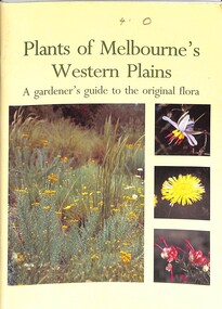
Booklet - Plants of Melbourne's Western Plains A Gardener's guide to the original flora, Keilor Plains Group, 1995
... Plants of Melbourne's Western Plains A Gardener's guide to the original flora...Plants of Melbourne's Western Plains A Gardener's guide to the original flora...... Western Plains...Plants of Melbourne's Western Plains A Gardener's guide to the original flora...Plants Western Plains Plants of Melbourne's Western Plains A Gardener's guide to the original flora Soft covered book Plants of Melbourne's Western Plains A Gardener's guide to the original flora Booklet Plants of Melbourne's Western Plains A Gardener's guide to the original flora Keilor Plains Group ...Soft covered bookplants, western plains -
 Ballarat Clarendon College
Book, Claud Notman, Of sheep and men: a story of the flocks, the founders and descendants of Victoria's Western Plains over a period of almost 200 years in Australia's history, 1981
... Of sheep and men: a story of the flocks, the founders and descendants of Victoria's Western Plains over a period of almost 200 years in Australia's history...Handwritten on endpage: From Skips Bookshelves / 30/3/1992 / to the young folks of the future Handwritten on inside flyleaf: Claud Notman / 10/10/81 Handwritten on title page: For, the boys of today, / to learn of the, hard times / of years ago / Skipper / 24/4/1993 / Boys note Small hardback book Of sheep and men: a story of the flocks, the founders and descendants of Victoria's Western Plains over a period of almost 200 years in Australia's history Book Claud Notman ...Claud Notman served on the Ballarat College council 1958 - 1973. An old Geelong College collegian he wrote several books relating to the history of Skipton. This book indexes the families or individual associated with Ballarat College from its earliest beginnings. Small hardback bookHandwritten on endpage: From Skips Bookshelves / 30/3/1992 / to the young folks of the future Handwritten on inside flyleaf: Claud Notman / 10/10/81 Handwritten on title page: For, the boys of today, / to learn of the, hard times / of years ago / Skipper / 24/4/1993 / Boys noteclaud notman, sheep industry -- victoria -- western district -- history. -
 Victorian Railway History Library
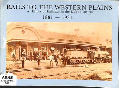
Book, Oates, Gordon et al, Rails to the Western Plains: A History of Railways in the Dubbo District 1881-1981, 1981
... Rails to the Western Plains: A History of Railways in the Dubbo District 1881-1981...Rails to the Western Plains: A History of Railways in the Dubbo District 1881-1981 Book Oates, Gordon Oates, Pam Gordon & Pam Oates ...A history of the railways in the Dubbo District of New South Wales.ill, maps, p.95.non-fictionA history of the railways in the Dubbo District of New South Wales.railroad construction - new south wales - history, railroad operations - new south wales - history -
 Linton and District Historical Society Inc
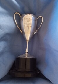
Trophy, Henry Brunn Cup, 1957 : won by D. Hart
... ...Western Plains Football League...The Western Plains Football League operated in Victoria from 1930 to 1998. ...Linton and District Historical Society Inc 69 Sussex Street Linton 3360 goldfields The Western Plains Football League operated in Victoria from 1930 to 1998. ...The Western Plains Football League operated in Victoria from 1930 to 1998. Participating football clubs included Carngham-Linton, Cressy, Illabarook, Lismore, Rokewood, and Skipton. The Henry Brunn Cup was awarded to the Best & Fairest player.Silver plated trophy cup with handles, on circular Bakelite base."HENRY BRUNN CUP / 1957 / W.P.F.L. / Best & Fairest / Won by / D. Hart"dean hart, western plains football league -
 Department of Health and Human Services
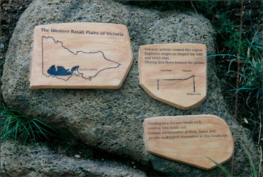
Photograph, Parkville Youth Training Centre - Plaque title "The Western Basalt Plains of Victoria"
... Parkville Youth Training Centre - Plaque title "The Western Basalt Plains of Victoria" ...Department of Health and Human Services 50 Lonsdale St Melbourne melbourne Parkville Youth Training Centre - Plaque title "The Western Basalt Plains of Victoria" Photograph Photograph ... -
 Linton and District Historical Society Inc
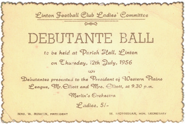
Card - Ticket, Linton Football Club Ladies' Committee Debutante Ball, 1956
... Debutantes to be presented to the President of the Western Plains League, Mr. Elliott, and to Mrs. ...Text: ' Linton Football Club Ladies' Committee / DEBUTANTE BALL / to be held at Parish Hall, Linton / on Thursday, 12th July, 1956 / Debutantes presented to the President of Western Plains / League, Mr. Elliott and Mrs. Elliott, at 9.30 p.m. / Merlin's Orchestra / MRS. ...Debutantes to be presented to the President of the Western Plains League, Mr. Elliott, and to Mrs. ...Gold-edged yellow ticket with gold lettering, ticket for a debutante ball to be held in the Parish Hall, Linton on Thursday 12th July, 1956. Debutantes to be presented to the President of the Western Plains League, Mr. Elliott, and to Mrs. Elliott. Text: ' Linton Football Club Ladies' Committee / DEBUTANTE BALL / to be held at Parish Hall, Linton / on Thursday, 12th July, 1956 / Debutantes presented to the President of Western Plains / League, Mr. Elliott and Mrs. Elliott, at 9.30 p.m. / Merlin's Orchestra / MRS. W. RINGIN, PRESIDENT M. MOYNIHAN, HON. SECRETARY. ' linton football club ladies' committee, sports, social gatherings, debutante balls, debutantes, mrs. w. ringin, m. moynihan -
 Bacchus Marsh & District Historical Society
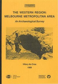
Book, The Western Region: Melbourne Metropolitan Area: An Archaeological Survey
... Aboriginal Australians Victoria Western Plains...The specific aim of the study was to investigate the Aboriginal archaeology of the Western Plains area in the vicinity west of Melbourne. ...This study aimed to locate and document Aboriginal archaeological sites in the western region of Melbourne. This area was defined by the study as extending out from the western suburbs of Melbourne to the Brisbane Ranges and north beyond Bacchus Marsh. The specific aim of the study was to investigate the Aboriginal archaeology of the Western Plains area in the vicinity west of Melbourne. The Bacchus Marsh, Melton and Werribee shire boundaries of the time defined the areas of the study. The study contains extensive lists of the types of artifacts found the the locations where they were found.Soft cover foolscap size book. 96 pages with b & w illustrations, images and maps (some folded). Part of Occasional reports series (Victoria Archaeological Survey) ; No. 27. Published by Department of Conservation and Environment, Melbourne, 1990. Author, Hilary Du Cros. BMDHS Loc. AR/SU5This study aimed to locate and document Aboriginal archaeological sites in the western region of Melbourne. This area was defined by the study as extending out from the western suburbs of Melbourne to the Brisbane Ranges and north beyond Bacchus Marsh. The specific aim of the study was to investigate the Aboriginal archaeology of the Western Plains area in the vicinity west of Melbourne. The Bacchus Marsh, Melton and Werribee shire boundaries of the time defined the areas of the study. The study contains extensive lists of the types of artifacts found the the locations where they were found. aboriginal australians victoria western plains, aboriginal artifacts, archaelogical sites victoria western plains, aboriginal artifacts bacchus marsh region -
Federation University Historical Collection
Document, C.E. Hounam et al, Commonwealth of Australia Bureau of Meteorology - Climate of the Basaltic Plains of Western Victoria, 1963
... Commonwealth of Australia Bureau of Meteorology - Climate of the Basaltic Plains of Western Victoria...Symposium - Royal Society of Victoria "Basaltic Plains of Victoria" 12 September 1963 Brown cardboard covered foolscap sized typed document with diagrams Commonwealth of Australia Bureau of Meteorology - Climate of the Basaltic Plains of Western Victoria Document C.E. Hounam F.A. ...Brown cardboard covered foolscap sized typed document with diagrams Handwritten on front. Symposium - Royal Society of Victoria "Basaltic Plains of Victoria" 12 September 1963basaltic plains of victoria, royal society of victoria, commonwealth of australia bureau of meteorology, c.e. hounam, f.a. powell, symposium, maps -
Stawell Historical Society Inc
Ceremonial object - Realia, Carved Aboriginal Shield
... Believed to have come from Hopwood Property near Mt Egerton Near Gordon Western Plains ...Stawell Historical Society Inc 46 Longfield St Stawell grampians Believed to have come from Hopwood Property near Mt Egerton Near Gordon Western Plains Parallel groves on face Carved Curved Shield with handgrip, front has parallel groves covered in Ochre. ...Believed to have come from Hopwood Property near Mt Egerton Near Gordon Western Plains Carved Curved Shield with handgrip, front has parallel groves covered in Ochre. Parallel groves on face -
Stawell Historical Society Inc
Ceremonial object - Realia, Woomera like object possibly Sacred Object Kulpidje
... Believed to have come from Hopwood Property near Mt Egerton Near Gordon Western Plains ...Stawell Historical Society Inc 46 Longfield St Stawell grampians Believed to have come from Hopwood Property near Mt Egerton Near Gordon Western Plains Indigenous Parallel groves on face Carved on front, with snaking pattern of groves. ...Believed to have come from Hopwood Property near Mt Egerton Near Gordon Western Plains Carved on front, with snaking pattern of groves. Small Hole on one end. Made of wood with curved back. Parallel groves on faceindigenous -
 8th/13th Victorian Mounted Rifles Regimental Collection
Photograph
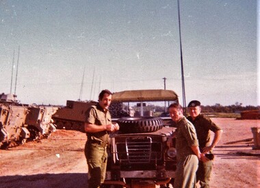
... The western plains of southern NSW provided ideal training areas for a cavalry squadron engaged in reconnaissance training....8th/13th Victorian Mounted Rifles Regimental Collection 4/19 Prince of Wales's Light Horse Simpson Barracks McLeod melbourne The western plains of southern NSW provided ideal training areas for a cavalry squadron engaged in reconnaissance training. ...The western plains of southern NSW provided ideal training areas for a cavalry squadron engaged in reconnaissance training.Colour photograph of three officers of 8/13 Victorian Mounted Rifles standing near Land Rover during annual exercise in Balranald area c. 1979. From left: Lieutenant T. Goode, Captain J. Mclean and Captain T. fraser. -
 8th/13th Victorian Mounted Rifles Regimental Collection
Photograph
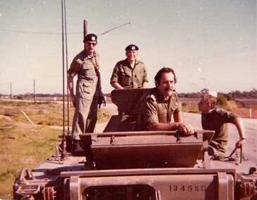
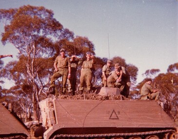
... Western plains of southern New South Wales provided good training areas for a unit practicing reconnaissance tasks....8th/13th Victorian Mounted Rifles Regimental Collection 4/19 Prince of Wales's Light Horse Simpson Barracks McLeod melbourne Western plains of southern New South Wales provided good training areas for a unit practicing reconnaissance tasks. ...Western plains of southern New South Wales provided good training areas for a unit practicing reconnaissance tasks.Colour photograph of four 8/13 Victorian Mounted Rifles soldiers on an M113 Light Reconnaissance Vehicle ( LRV ) during Annual exercise at Balranald NSW. From left: Lance Corporal lM. Roberts, Captain T. Fraser, Lieutenant T. Goode and Trooper Bone. -
 Federation University Historical Collection
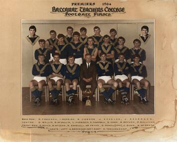
Photograph - Photograph - Colour, N. L. Harvey, Ballarat Teachers' College: Football Firsts Premiers, 1964, 1964
... Team Member Garry Dark won the Brunn Trophy for Best and Fairest in the now defunct Western Plains League, and went on to play for Footscray in the Victorian Football League....Barker Library (top floor) Mount Helen goldfields Team Member Garry Dark won the Brunn Trophy for Best and Fairest in the now defunct Western Plains League, and went on to play for Footscray in the Victorian Football League. ballarat teachers' college football j scanlon premiers r freeman i morrish r umbers j sharrock d wallis b mcmullin l harrison r braszell e campbell barrie beynon g dark d sullivan d royce b mccann g powell captain j gunn k mcgrath n broad vice-captain d teschendorf garry dark peter fryar australian rules football gary powell Colour photograph of football team. ...Team Member Garry Dark won the Brunn Trophy for Best and Fairest in the now defunct Western Plains League, and went on to play for Footscray in the Victorian Football League.Colour photograph of football team. Mounted on heavy card Names of player printed below photoballarat teachers' college, football, j scanlon, premiers, r freeman, i morrish, r umbers, j sharrock, d wallis, b mcmullin, l harrison, r braszell, e campbell, barrie beynon, g dark, d sullivan, d royce, b mccann, g powell, captain, j gunn, k mcgrath, n broad, vice-captain, d teschendorf, garry dark, peter fryar, australian rules football, gary powell -
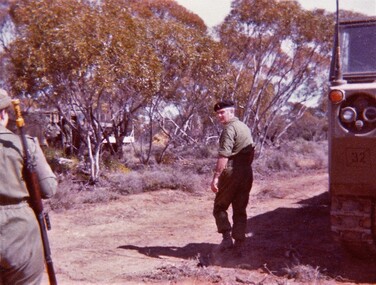 8th/13th Victorian Mounted Rifles Regimental Collection
Photograph
... Western plains of southern NSW provided good training areas for a unit practicing reconnaissance skills. ...8th/13th Victorian Mounted Rifles Regimental Collection 4/19 Prince of Wales's Light Horse Simpson Barracks McLeod melbourne Western plains of southern NSW provided good training areas for a unit practicing reconnaissance skills. ...Western plains of southern NSW provided good training areas for a unit practicing reconnaissance skills. Technical Support Troop provided first line repair and recovery to the reconnaissance squadron.Colour photograph of Sergeant Viv Schmidt, Technical Support Troop ( TST ) A Squadron 8/13 Victorian Mounted Rifles standing beside a M 548 tracked load Carrier ( TLC ) on exercise near Balranald NSW.military, training, vehicle, vmr, victorian mounted rifles -
Federation University Art Collection
Oil on primed paper, Whitson, Robert, 'Construction' by Robert Whitson, 2002
... The project was concerned with a visial exploration of the land of the Western Plains of Victoria and the nature of 'the sacred' in the landscape. ...The project was concerned with a visial exploration of the land of the Western Plains of Victoria and the nature of 'the sacred' in the landscape. ...Robert WHITSON (1962- ) Born Mortlake, Victoria Robert Whitson studied Fine Art at the University of Ballarat (now Federation University) from 1980 to 1983, returning to undertake Honours. He completed a Masters degree in 2002 at the University of Ballarat. This item is part of the Federation University Art Collection. The Art Collection features over 1000 works and was listed as a 'Ballarat Treasure' in 2007.Framed artwork which forms part of the Robert Whitson's Masters folio "Sacred Landscape: An Unsettling". The project was concerned with a visial exploration of the land of the Western Plains of Victoria and the nature of 'the sacred' in the landscape. The artwork attemts to develop images of layered multiple histories, juxtaposed within the landscape. art, artwork, robert whitson, landscape, oil on paper, alumni -
 Coal Creek Community Park & Museum
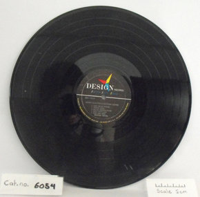
Phonograph record, Jimmy Clanton & Bristow Hopper; Love has no strings, Just a dream, etc
... Vinyl LP with black 'Design Records' label; Spectra Sonic Sound Jimmy Clanton & Bristow Hopper - TRACKS: Just a Dream, Angel Face, The Slave, Please Me, I Need to Be Loved, Love Has No Strings, Foolish Thing, Baby That's Love, Hate That Bear, Rolling Western Plains. Ref. DLP-176-A...Coal Creek Community Park & Museum 12 Silkstone Road Korumburra gippsland Vinyl LP with black 'Design Records' label; Spectra Sonic Sound Jimmy Clanton & Bristow Hopper - TRACKS: Just a Dream, Angel Face, The Slave, Please Me, I Need to Be Loved, Love Has No Strings, Foolish Thing, Baby That's Love, Hate That Bear, Rolling Western Plains. Ref. DLP-176-A Jimmy Clanton & Bristow Hopper; Love has no strings, Just a dream, etc. ...Vinyl LP with black 'Design Records' label; Spectra Sonic Sound Jimmy Clanton & Bristow Hopper - TRACKS: Just a Dream, Angel Face, The Slave, Please Me, I Need to Be Loved, Love Has No Strings, Foolish Thing, Baby That's Love, Hate That Bear, Rolling Western Plains. Ref. DLP-176-A -
 Sunbury Family History and Heritage Society Inc.
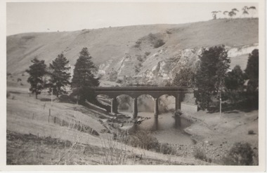
Photograph, Bulla Bridge, 27 June 1934
... It has been constructed from bluestone which is found across the volcanic western plains in Victoria. Kaolin was quarried from the cliff face in the background and was used in the making of bricks and pottery products manufactured at Northcote and Brunswick potteries.The bridge was built in 1869....It has been constructed from bluestone which is found across the volcanic western plains in Victoria. Kaolin was quarried from the cliff face in the background and was used in the making of bricks and pottery products manufactured at Northcote and Brunswick potteries.The bridge was built in 1869. ...This is a photograph of the bridge in the Bulla township which spans the Deep Creek, a tributary of the Maribyrnong River. It has been constructed from bluestone which is found across the volcanic western plains in Victoria. Kaolin was quarried from the cliff face in the background and was used in the making of bricks and pottery products manufactured at Northcote and Brunswick potteries.The bridge was built in 1869.This is one of the many notable bluestone bridges which were built in the district in the nineteenth century.A non-digital black and white photograph of a valley with a five arched bridge spanning a river. There are high cliffs in the background. Information about the bridge has been written on then back of the photograph. The image was published in then Weekly Times on 23rd December 1933.bulla township, deep creek, bridges -
 Sunshine and District Historical Society Incorporated
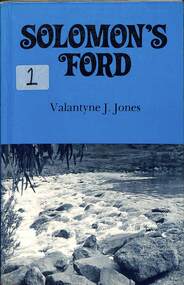
Book - Solomon's Ford, Valantyne J. Jones, Solomon's Ford. Valantyne J Jones, 1983
... It is recorded in the first accounts of exploration (Grimes' 1803 journey) and in subsequent accounts of the difficulties of traversing the western plains. The ford was later named Solomon's Ford after Michael Solomon, early Keilor district squatter and grazier who came to the area in 1835....It is recorded in the first accounts of exploration (Grimes' 1803 journey) and in subsequent accounts of the difficulties of traversing the western plains. The ford was later named Solomon's Ford after Michael Solomon, early Keilor district squatter and grazier who came to the area in 1835. ...A history of Solomons Ford, located in Canning Street Avondale Heights.Small paper back book with picture of Solomon's Ford on frontnon-fictionA history of Solomons Ford, located in Canning Street Avondale Heights.solomon, braybrook, maribyrnong river, valantyne jones -
 Sunshine and District Historical Society Incorporated
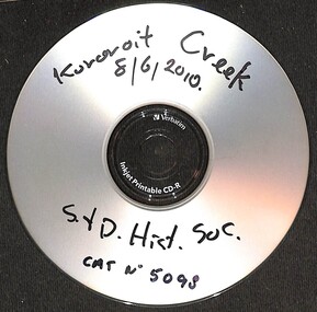
Photograph - Kororoit Creek Photograph Compilation
... The name Kororoit is thought to have been derived from an Aboriginal word meaning male kangaroo, but the meaning is in dispute, the name may be also derived from the Woiwurrung language, meaning “Creek on the western plain"....The name Kororoit is thought to have been derived from an Aboriginal word meaning male kangaroo, but the meaning is in dispute, the name may be also derived from the Woiwurrung language, meaning “Creek on the western plain". Kororoit Creek Korotoit Creek 8/6/2010 CD with a compilation of Kororoit Creek photographs from the collection of the Sunshine & District Historical Society Photograph Kororoit Creek Photograph Compilation ...Kororoit Creek flows through Albion, Deer Park & Sunshine. It is a vital ecological corridor and recreational trail, known for its basalt cliffs, revegetation efforts, and community significance. Kororoit Creek has deep Aboriginal significance, with evidence of long-standing occupation and cultural practices along its banks. The area surrounding Kororoit Creek is part of the traditional lands of the Wurundjeri Woi-wurrung people, who belong to the Kulin Nation. The name Kororoit is thought to have been derived from an Aboriginal word meaning male kangaroo, but the meaning is in dispute, the name may be also derived from the Woiwurrung language, meaning “Creek on the western plain".Korotoit Creek 8/6/2010kororoit creek -
 8th/13th Victorian Mounted Rifles Regimental Collection
Photograph
... The western plains of southern NSW provided ideal training areas for units practicing reconnaissance skills sso were frequently used.The 8th/13th Victorian Mounted Rifles was raised as a regiment of the Royal Australian Armoured Corps on 1 May 1948 with Headquarters in Melbourne and squadrons in Sale, Benalla/Wangaratta and Albury. ...8th/13th Victorian Mounted Rifles Regimental Collection 4/19 Prince of Wales's Light Horse Simpson Barracks McLeod melbourne The western plains of southern NSW provided ideal training areas for units practicing reconnaissance skills sso were frequently used.The 8th/13th Victorian Mounted Rifles was raised as a regiment of the Royal Australian Armoured Corps on 1 May 1948 with Headquarters in Melbourne and squadrons in Sale, Benalla/Wangaratta and Albury. ...The western plains of southern NSW provided ideal training areas for units practicing reconnaissance skills sso were frequently used.The 8th/13th Victorian Mounted Rifles was raised as a regiment of the Royal Australian Armoured Corps on 1 May 1948 with Headquarters in Melbourne and squadrons in Sale, Benalla/Wangaratta and Albury. In 1955 Regimental Headquarters moved to Wangaratta and a second squadron was located at Albury. The Sale squadron transferred to 4th/19th Prince of Wales’s Light Horse. In 1977 8/13 VMR Regiment was reduced to an independent squadron A Squadron 8th/13th Victorian Mounted Rifles and in 1991 was linked with 4th/19th Prince of Wales’s Light Horse forming the VMR Squadron of that regimentColour photograph of 8/13 Victorian Mounted Rifles soldiers standing on top of M113 Light Reconnaissance Vehicle { LRV ) during annual exercise near Balranald NSW, 1985. From left : Corporal Anton Florent, Corporal Peter Hicks, Lance Corporal Terry Mitchell.Centre group unknownAt right seated : Corporal Doug Cameron. -
 Sunshine and District Historical Society Incorporated
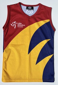
Uniform - Brimbank Little Athletics Competition Uniform
... The yellow wheat graphic represents the area’s history of agriculture manufacture and the flat grassy landscape of the western plains, and is an adoption from the City of Brimbank's logo. ...The yellow wheat graphic represents the area’s history of agriculture manufacture and the flat grassy landscape of the western plains, and is an adoption from the City of Brimbank's logo. ...Brimbank Little Athletics Centre is one of Victoria's Little Athletics registered clubs. These clubs offer track and field programs for children aged 5–17, promoting fitness, fun, and personal achievement. The three colours represents the colours of the three individual centres that were merged in 2000, Deer Park (Yellow), Red (St. Albans) & Blue (Sunshine) to form the Brimbank Little Athletics Centre. The yellow wheat graphic represents the area’s history of agriculture manufacture and the flat grassy landscape of the western plains, and is an adoption from the City of Brimbank's logo. On the back, the 151, means the centre is the 151th registered Little Athletics Centre in Victoria. This competition top was used at the local centre competition days including regional & state events.Yellow, red & blue sleeveless polyester athletic size 8 competition uniform.Front - Little Athletics Victoria with Little Athletics logo Back - Brimbank Little Athletics Centre 151brimbank little athletics, little athletics, athletics -
 Warrnambool and District Historical Society Inc.
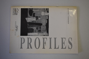
Booklet, Profiles Warrnambool Art Gallery Catalogue, 1994
... It was intended to be the first of similar exhibitions and was initiated by the Warrnambool-based Cultural Association of the South Coast and Western Plains. The Warrnambool Art Gallery was officially opened in 1886 though the local Mechanics’ Institute and Museum had been collecting works of art before this date. ...It was intended to be the first of similar exhibitions and was initiated by the Warrnambool-based Cultural Association of the South Coast and Western Plains. The Warrnambool Art Gallery was officially opened in 1886 though the local Mechanics’ Institute and Museum had been collecting works of art before this date. ...This booklet is a catalogue of most of the works of art that were displayed in an exhibition in the Warrnambool Art Gallery in 1994. It was described as ‘a celebration of artists committed to living and working in country Victoria’. It was intended to be the first of similar exhibitions and was initiated by the Warrnambool-based Cultural Association of the South Coast and Western Plains. The Warrnambool Art Gallery was officially opened in 1886 though the local Mechanics’ Institute and Museum had been collecting works of art before this date. When the Mechanics’ Institute building was taken over for Council use in 1963 the Art Gallery ceased to exist and the works put in storage. The Gallery re-opened in temporary premises in 1971 and the present Warrnambool Art Gallery, a memorial to Fletcher Jones, was opened in 1986 in Liebig Street. This is an interesting catalogue as it is one of the few examples we have of the work of the Cultural Association of the South Coast and Western Plains. This Warrnambool-based group operated for a short time only in the 1990s.This is a soft cover booklet of 40 pages. It is bound with metal staples. It has a white cover with black printing and reproductions of black and white works of art on the front and back covers. The booklet contains reproductions of the works of art (in black and white) by 34 south west Victoria artistswarrnambool art gallery, history of warrnambool -
 Lake Bolac & District Historical Society
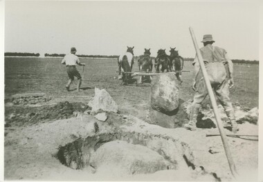
Black and white photograph, Grubbing rocks at "Boswell Park", Lake Bolac
... Most ground on the Western District volcanic plains had to be prepared in this way before the soil could be tilled. ...Most ground on the Western District volcanic plains had to be prepared in this way before the soil could be tilled. ...Grubbing rocks at "Boswell Park" Lake Bolac, in order to prepare the ground for ploughing and cropping. Most ground on the Western District volcanic plains had to be prepared in this way before the soil could be tilled. "Boswell Park" was run by the Moreton family.lake bolac, boswell park, grubbing rocks, moreton, cropping -
 Melton City Libraries
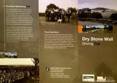
Pamphlet, Dry Stone Wall Driving Trail, Unknown
... In the case of the dry stone walls built around Melton, the characteristic round or oval shape of the volcanic fieldstones on the western plains inspired some distinctive designs.54 Another advantage of dry stone walls was their ability to withstand the ravages of flood, fire and drought often experienced in the district. ...In the case of the dry stone walls built around Melton, the characteristic round or oval shape of the volcanic fieldstones on the western plains inspired some distinctive designs.54 Another advantage of dry stone walls was their ability to withstand the ravages of flood, fire and drought often experienced in the district. ..."The dry stone walls provide a tangible link to the area’s white settlement, and they remain a symbol of the profound change in land usage from the original Kulin custodians to the European arrivals of the nineteenth century. The bulk of dry stone wall construction in Victoria occurred between the 1850s and 1880s. The gold rush of the early 1850s in particular inspired a flurry of construction. At this time, labour previously available for shepherding livestock dried up, as men gravitated to the goldfields to seek their fortunes. This necessitated the building of fencing to contain the district’s growing number of sheep, cattle and horses. An explosion in surveying, subdivision and the sale of Crown lands also contributed to a boost in construction. Government regulations that punished pastoralists for allowing their livestock to stray provided further incentive to fence-off previously open expanses of land. The major benefit of this type of fencing was that it utilised the materials at hand; the plentiful grey basalt that scattered the landscape. In the case of the dry stone walls built around Melton, the characteristic round or oval shape of the volcanic fieldstones on the western plains inspired some distinctive designs.54 Another advantage of dry stone walls was their ability to withstand the ravages of flood, fire and drought often experienced in the district. This durability accounts for the fact that many of these fences still exist today". Dry Stone Wall trail brochure/pamphlet for visitors provided by Melton Visitor Information Centrecouncil, landscapes of significance -
 Merri-bek City Council
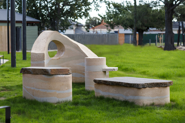
Sculpture - Rammed earth, basalt, mudstone, Isadora Vaughan, Terra Pneumatics, 2021
... The City of Merri-bek and Glenroy lie on the Western Basalt plains of Victoria, with soil and bluestone derived from ancient volcanic lava flows. ...The City of Merri-bek and Glenroy lie on the Western Basalt plains of Victoria, with soil and bluestone derived from ancient volcanic lava flows. ...Located at the Glenroy Community Hub, Isadora Vaughan’s rammed earth and bluestone sculpture draws attention to the continual transformation of Glenroy’s geology and its communities. The City of Merri-bek and Glenroy lie on the Western Basalt plains of Victoria, with soil and bluestone derived from ancient volcanic lava flows. Vaughan’s sculpture is created from these locally found sediments with the range of colours and textures reflecting the changing use of the land as various soils, rocks and sand were introduced from the coastal areas of Victoria. These forms reflect Glenroy’s changing communities, emphasising our relationship with the earth, and have been shaped to enable connection through offering places to sit, lean, play and to gather. Terra Pneumatics embodies the history and sediment of Glenroy —both human and geological — and invites the community to become part of this process of layering and transformation.merri-bek public art collection -
 Melton City Libraries
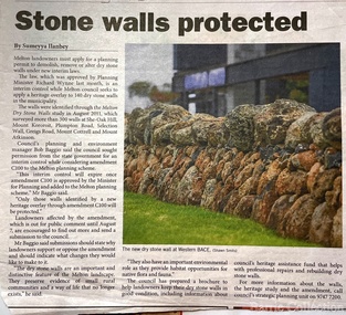
Newspaper, Stone Walls protected, 2015
... Across the volcanic plains of western Victoriaare marvelous sheep dips, stock loading ramps, huts, dams, retaining walls, and the rich and largely undiscovered heritage of indigenous dry stone structures. ...Across the volcanic plains of western Victoriaare marvelous sheep dips, stock loading ramps, huts, dams, retaining walls, and the rich and largely undiscovered heritage of indigenous dry stone structures. ...Dry stone construction as a technique is used for much more than paddock walls. Across the volcanic plains of western Victoriaare marvelous sheep dips, stock loading ramps, huts, dams, retaining walls, and the rich and largely undiscovered heritage of indigenous dry stone structures. Dry stone walls indicate many aspects of our rural environment; the geological beginnings of the way the landscape was created, the patterns of early settlement by pastoralists and squatters, the types of stock that grazed the land and the methods of cattle and sheep management, of the efforts to thwart the spread of rabbits .... "For the casual but interested observer dry stone walls are good to look at, to photograph, to get up alongside and see the way they are constructed, to appreciate the varying shapes and sizes of stones and learn of the techniques of keeping often quite rounded stones in place. Apart from walls and other dry stone structures on grazing land we can also see dry stone techniques used in other places and in other phases of our history. Indigenous Australians have built, and continue to build, structures for shelter or hunting or trapping eels and fish in rivers and estuaries around the country. At spots around our coast line there is evidence of simple stone structures built by early maritime explorers. Prospectors in early mining encampments used dry stone construction to build retaining walls or the low walls of rudimentary shelters. If the future of dry stone walls in the Australian landscape is to be assured. wall owners and local governments have to accept and embrace their custodial role in assuring the preservation and celebration of walls. This is not an easy task, but, along with putting the necessary statutory mechanisms to ensure their retention, it is a task that must be pursued. The Dry Stone Walls Association of Australia has as its primary goal the increase in awareness of wall owners and local governments of the importance of dry stone walls. It also seeks to increase the level of training of skilled and semi skilled wallers, and the gaining of rudimentary skills by farmers so that they can maintain their own walls". Melton Star Weekly article about the Stone Wallslandscapes of significance -
Federation University Historical Collection
Document, Zelda Martin, Central Victorian Goldmining towns - Boom Towns or Ghost Towns?, c1996
... Friends of the State Library, 1989 +"The Public Lands of Australia Felix"; settlement and land appraisal in Victoria1834-91 with special reference to the Western Plains", J.M.Powell, Melb. Oxford University Press 1970 +*Bibliography of the Victorian Aborigines' from the earliest manuscripts to 31st December 1970, Massoa, Aldo, Melb. ...Friends of the State Library, 1989 +"The Public Lands of Australia Felix"; settlement and land appraisal in Victoria1834-91 with special reference to the Western Plains", J.M.Powell, Melb. Oxford University Press 1970 +*Bibliography of the Victorian Aborigines' from the earliest manuscripts to 31st December 1970, Massoa, Aldo, Melb. ...Zelda Martin was a PhD candidate at the University of Melbourne.[.1] 4th item in light blue display book titled Research Approach/Overview of Chapters/Confirmation of Canditure/Chapters1,2,3&4 of proposed thesis. *Twenty-seven page article on Victorian goldfields towns titled: Central Victorian Goldmining Towns - Boom Towns or Ghost Towns. The article was written during the author's PhD study. It outlines the context methodology, and resources and the chapters of the proposed thesis: (1) Central Victorian Goldmining Towns - The Context (2) Contemporary Views of the Factors Necessary for Town Growth (3) Outward Manifestations of Town Growth (4) The Trappings of Government (5-9) The Main Towns and Their Hinterland. [.2] 5th item in Light Blue display book as above item. *Chapter 1 of proposed thesis titled 'Pick, Shovel and Tin Dish Mining.' Covers in Section A: Central Victoria - Pre 1851: Aborigines in Central Victoria, Squatters, and Government. Section B: The years 1851-1854: The Early Gold Rushes, Government Reaction, Township Surveys, Legislation, Town Development, Local Government and Early Settlement. [.3] 6th item in Light Blue display book as above item. *2A of proposed thesis titled 'Contemporary Views of the Factors Necessary for Town Growth'. Similar information to Chapter 1 plus extra re towns and maps. Sections: Introduction, Context of Place - Geographical Towns Listed, The Context of Time - Pre1851 Aborigines, Governance of Port Phillip, The Squatters, The Villages of Central Victorian Highlands, Conclusion, Condensed Version of Chapter2B. [.4] 7th item in Light Blue display book as above item. *Chapter2B of proposed thesis. Sections: Area of Research, Schools, Banks, Newspapers, Progress Association, Town Development - Sandhurst (Bendigo), Ballarat, Castlemaine,, Maryborough, Ararat and Stawell. [.5] 8th item in Light Blue display book as above item. *Chapter 3 of proposed thesis titled 'Outward Manifestations of Town Growth'. Sections: Introduction, Contemporary Writing, Educationalists, The Bankers, The Townsfolk, Current Theory, General Theories of Urban Development, and Conclusion. [.6] 9th item in Light Blue display book as above item. *Chapter 4 of proposed thesis titled 'Trappings of Government' Sections: Introduction, Early Government Attitudes to Mining and Town Development, Law and Order, Township Surveys, Legislation, Local Government, Transport and Communication, The People and Lobbyists. [.7] 10th item in Light Blue display book as above item. *'The Rise and Fall of Central Victorian Goldmining Towns'. Includes a map showing main Goldfields, a table showing towns and villages at two points in time - 1857 and 1871; a Bibliography of Primary and Secondary Sources. [.8] Resource No1. Black display book titled Local Towns 1 : Alma: *Brief history *Directory *Maps Amphitheatre / Mountain Hut: *Brief History Post Office Directory Ararat: *Brief History *Post Office Directory 1869 - Alphabetical Listing by Occupation *Ararat - Prominent Citizens of 1858 *Langi-Morgala Museum Avoca: *Brief History *Excerpts from 'Avoca The Early Years', Margery and Betty Beavis; pg1 - Beginnings; pg11 - The Midas Touch; pg25 - Local Gold Escorts; pg27 - A Town is Born; pg51- The Administration of Justice; pg53 - The Ways of the Law; pg61 - News of the Day; pg65 - A Time to Play; pg72 - Land Ownership *Post Office Directory (Bailliere's) 1869 *Tourism Map and Information of area *Historic Avoca - A 5.5km Tour *Avoca & the Pyrenees Region - information pamphlet Ballarat: *Early History of Ballarat - Ballarat Historical Society, Publication No.1: origin of the name; Ballaarat - the Beginning; Fabulous Yields from the Ballaarat Goldfield; *Streetscape Lydiard Street. *Hand drawn map showing Leigh River, Old Portland Bay Road, plaque on road to Colac; etc. *Newspaper article re 'The Theatre Royal' ( which stood in the vicinity of the current Owen Williams store) - 'The News'15/04/1998 *Article - 'Ballarat's Mechanics' Institute Lives On' Ballarat Courier, 14/09/1985 *Article - Standing the Test of Time' The News 17/11/1993 re The Mechanics Institute & picture of the Reading Room *'Ballarat a Study of a City, Phyllis Reichl, pub. Nelson, 1968; no.3 place, time and people field studies series *Investigator Vol.33 No.2, 1998 Geelong Historical Society. Article on pg75 describes Ballarat in 1861 *Folded poster - 'Ballarat 100' a history of telegraph communication, pub. Telecom. Beaufort (Fiery Creek): *Brief history *Post Office Directory [.9] Resource No.2 Black Folder Titled Towns cont.No2 Bendigo (Sandhurst): *'Family & Local History at the Bendigo Library - 1851-2001 150 years of gold'. *Bendigo Government Camp in 1853 illustration; key to sketch and names of Government officers stationed there *Excerpts from 'Bendigo and Vicinity' Adolph Haman *The Bendigo Goldfield Registry - pgs 1-7 Introduction *Excerpt: 'Breaking the Grip' *Excerpt: The Most Go-Ahead Place *Excerpts from 'History of Bendigo' - anti license agitation; laying out of town; proposed railway; gold calls and dividends; the Sandhurst Municipality; journalism *Bibliography Blackwood: *Excerpts from 'Aspects of Early Blackwood - The Goldfield, the Landmarks, the Pioneers' Alan J Buckingham and Margaret F Hitchcock, JG Publishing,1980 Buninyong: *A Brief History *Investigator Vol1 No.2 Feb 1966 Geelong Historical Society. Pg3 - Article re gold escort route - Mt Alexander to Adelaide - (see a simple monument on the Western Highway a few miles out of Horsham. Pg 15 - Ballarat Excursion - re the finding of gold. *Three articles published by Buninyong and District Historical Society Inc: (Magpie Exploration; Finding Gold In The Green Hills; Magpie Exploration; Burnt Bridge to Cargarie to Mt Mercer) *Copies of newspaper articles/items *Buninyong Street Directory Carisbrook: *In the Beginning There Was Carisbrook *The History of the Carisbrook Racecourse Carngham / Snake Valley: *Brief History *Directory Castlemaine: *Directory 1865-1866 - Alphabetical and Street *Poster - Castlemaine A Contemporary Guide "The Great Centre" 1866 - A Contemporary Guide to the Fascinating Past *Pamphlet - Castlemaine District Community Hospital *Map - Castlemaine, Maldon & Surrounding Districts *Map and Information - The Dry Diggings Track - a 55kl walk among historic goldfields relics ( Castlemaine Fryerstown Vaughan Mt Franklin Hepburn Daylesford) *Postcard - Former Court House *Directory 1867 - Alphabetical, Trade [.10] Resource No.3 Grey folder Titled Towns 3 Creswick to Maryborough Creswick: *Brief History *Booklet - "Creswick Cemetery Walk" *Booklet - The Buried Rivers of Gold Heritage Trail Creswick *Creswick Historical Museum Information Sheet *Chronological History of Creswick *Alphabetical Directory of the Borough of Creswick *Creswick's Creek Directory 1856 *Historic Creswick Walking Tour *A Brief Account of the Schools of Creswick - Past and Present *100 Years of Railway Travel in Creswick *The Berry Deep Leads *The Spence Home at Jackass Gully in the Creswick State Forest ( William Guthrie Spence - Pioneer) *The New Australian Mine and the 1882 Disaster *Creswick District News, Issue 7, July August 1999 *The Creswick Miners Walk - Information and Map *Maps Chewton: *Brief History *Directory Clunes: *Brief History *Clunes Street Directory Daylesford: *Brief History *Notable Bushfires in Daylesford District Over More Than a Century - "Black Thursday" 1851; 1862; 1899; the Disastrous Hepburn Fire of 1906; 1939; 1944; 1969. *Post Office Directory -Daylesford and Hepburn Dunolly / Inkerman: *Brief History *Directory *Pamphlet - Goldfields Historical Museum *Pamphlet - Historic Dunolly - Victoria's Best Kept Secret *Map of Gold Workings at Dunolly Area - showing where the main gold rushes occurred *Brief History - Inglewood *Directory - Inglewood - Name Occupation, Dwelling Kingower: *Brief History *Directory - Name / Ocupation / Dwelling Linton / Happy Valley / Piggoreet: *Brief History *Directory - Lintons McIvor: *"A History of the Shire and the Township of Heathcote" by J.O. Randell Majorca: *Brief History *Official Post Office Directory 1869 - Name / Occupation/ Address Maldon (Tarrangower): *Brief History Part 1 *Brief History Part 2 *Post Office Directory *List - Alphabetical Order by Names plus Business and Trade (Tarrangower Times Oct/1858) *List - Alphabetical Order by Trade plus Name and Business *Directory - Name / Occupation / Dwelling Maryborough: *Worsley Cottage - built by Arthur Worsley, a contractor in stonework in 1894 [.11] Resource No. 4 Blue Display Book titled Towns 4 Moliagul to Stawell Moliagul: *Brief History *Moligul Legislative Assembly (Voting?) List - Names and Occupations *Moliagul Victorian Post Office Directory 1868 - Name / Ocupation / Address / Comments *"The Welcome Stranger" gold nugget *The Sunday School *The Welcome Stranger Discovery Walk - information and map Moonambel (Mountain Creek) Redbank *Brief History *List of names extracted from advertisments of the Pioneer and Mountain Creek Advertiser 16/02/1861. *Bailliere's Directory 1869 - Alphabetical List of Name / Occupation / Place St Arnaud: *Brief History Sebastapol: *Brief History *Directory 1869 - Alphabetical by Name; plus occupation and address. Browns and Scarsdale: *Brief History *Browns Street Directory - Name and Occupation Smythesdale: *Brief Description *Smythesdale Street Directory -Name and Occupation Stawell (Pleasant Creek) *Brief History *Victorian Official Post Office Directory - Name /Occupation / Dwelling *Chronology - 1841-1920 *Production of gold statistics - 1879 - 1900 *Big Hill *Extracts from "The Golden Years of Stawell". Chapt 1 - Stawell's Coming Out. Capt. 2 - The Gold Rush. Caapt.3 - Cradle of Democracy. Chapt.4 - The Reefs Becomes Stawell. Chapt. 5 - Rushing In. Chapt.6 - The Pioneers. Chapt 7 - The Decade of Optimism. [.12] Resource No. 5: Blue Display Book titled 'Towns Steiglitz to the The Golden Triangle. Steiglitz: Brief History Victorian Post Office Directory 1869 *Map of Steiglitz *List of maps relevant to Steiglitz history *Information 6 tables of data from "Reports of Mining Surveyors Talbot (Back Creek) Brief History Taradale: Post office Directory 1869 - Name/Occupation/Street. Also list in alphabetical order by Occupation Taradale *Chronological Reference to Taradale Mines *Water - The Coliban System of Waterworks *Joseph Brady *The Syphon Tarnagulla (Sandy Creek) *Brief History *Tarnagulla Businessmen Cameos to give depth to advertisments in 'The Tarnagulla Courier' various issues 1864-1871 *Directory - Name/Occupation /Address *List - Name/Business/Trade Wedderburn (Koorong) *Brief History *List - Name/Occupation The Golden Triangle: *The Early Rushes - Wedderburn / Moliagul / Sandy Creek - Tarnagulla / Jones Creek - Waanyarra / Kingower / Dunolly - Goldsborough / Inglweood *Census of 1857 - Population / Occupations *1858-1871 - A Time of Consolidation- Wedderburn / Moliagul / Sandy Creek- Tarnagulla / Arnold *Census 1871 - Population *Information gleaned from the census data - Demographics / Population / Occupations / marital / Birthplace / Religion / Literacy/ Occupation and Housing Cameos *Graphs - Birthplace of settlers /Male-Female Ratio / Married males / Children under 15 as Percentage of Population / Religion *Census 1857 - Statistical data *Maps *Bibliography [.13] Resource No. 6 - Black Display Book Information and Research in Central Victoria including: *Banking - Research from ANZ Bank Archives *Institutions - also includes articles listed from the Ballarat Times Newspaper *Australian mining History Association - A.M.H.A. Bibliography *Australia's Mining History * Bibliography - Land Surveys Victoria - *1853 Administration (Statistics and Other) includes: schools / ministers of religion / police / military / local administration / licences for sale of spirits / distances between various Victorian gold fields. * Victoria Government Gazette (Copy) - N0. 116, 12/12/1854 includes: Gold Felds Commission of Enquiry & No. 85, 15/09/1854 - Addresses presented to the Lieutenant Governor (Sir Charles Hotham) during his tour through the Gold Fields of Victoria,1854. Addresses on behalf of : the people of Bendigo; Members of the Church of England, Bendigo; Members of the Wesleyan Church on the Bendigo Gold Fields; Bendigo Gold District General Hospital; the Bendigo Prospecting Association; Committee of the Bendigo Local Exhibition; Bendigo District Medical Association; Coloured Americans Resident at Bendigo; German Inhabitants of Bendigo; Landowners, Inhabitants, and Miners of Castlemaine; Inhabitants of Forest Creek; Inhabitants of Heathcote and Gold Miners of McIvor; Residents and landholders of the District of Bacchus Marsh; Inhabitants of Kilmore and Vicinity. *Gold Fields Correspondence 1853: letter from Lieutenant Colonel Valiant, (Officer commanding the Troops in Victoria) to the Lieutenant Governor re threatened disturbance at Sandhurst (Bendigo) regarding the Gold License Fee. * Extracts from a book "Victoria" re Gold Fields Commission of Enquiry involving mainly Ballarat and Castlemaine and a chapter titled 'A Tour to the Victorian Gold-Fields' *Lists of central Victorian newspapers - listed by date published 1851to 1874; by first date available to State Library. *A list of cities and towns showing County, population in 1861 &1871, and municipal status. [.14] Resource no.7. Black display book. *Reference: Papers presented to Parliament Victoria - 1859-1860 4 volumes - relevant sections copied. Contains information on Branches of Government. General / Finance / Gold / Gazette / Commission and Warrant / Statistic. *Gold Fields Act. In accordance with the Act the gold fields are divided into six districts - Ballaarat, Castlemaine , Sandhurst, Avoca, Ararat, and Beechworth.. Official staff in each gold district consists of a Resident Warden, Wardens, Wardens' Clerks, Bailiffs, Chinese Protectors, Chinese Interpreters, and Mining Surveyors. *Gold Receiver *Gaols *Police magistrates and Clerks of Petty Sessions, etc. *Field Branch *Immigration and Emigration Overland - Chinese - 1859 *Population on the Goldfields *The Geological Survey - The Government Geologist is assisited by staff from four branches - the office Branch; the Publishing Branch; the Field Branch and the Museum Branch. *Commission to Enquire Into Sludge dated 10/02/1859 (Some sections copied) - Report to the Honorable Chief Commissioner of Public Works, Melbourne re the mode of carrying the sludge from the puddling mills in Sandhurst without interfering with the drainage of the town and the roads in the neighbourhood. [.15] Resource No.8: Camel display book titled Resource No. 8. Aborigines *Lists of book titles - +"Readings in Victorian prehistory" +"The Aborigines of Port Phillip" +Aboriginal languages and clans" +"A History of the Port Phillip District" +"Langi Ghiran 1: Aboriginal Rock...." +"Koorie History: sources for aboriginal studies in the State Library of Victoria", ed. Tom Griffiths, Melb. Friends of the State Library, 1989 +"The Public Lands of Australia Felix"; settlement and land appraisal in Victoria1834-91 with special reference to the Western Plains", J.M.Powell, Melb. Oxford University Press 1970 +*Bibliography of the Victorian Aborigines' from the earliest manuscripts to 31st December 1970, Massoa, Aldo, Melb. Hawthorn Press, 1971 +"Aborigines in Colonial Victoria, 1836-1886", M.F. Christie, Sydney University Press, 1979 +"Urban and Industrial Australia: readings in Human Geography" ed J.M. Powell, Melb. Sorrett Pub. 1974 *Extracts: -Processes of Pioneer Settlement - The Squatting Occupation of Victoria, 1834-60. J.M. Powell -Areal Variations in the Class Structure of the Central-Place Hierarchy. P. Scott - Volume1 and Volume 2: Notes Relating to the Habits of the Natives of Other Parts of Australia and Tasmania. Compiled from various sources for the Government of Victoria by R Brough Smyth. John Curry, O'Neil, Melb. 1st pub. Melb. 1876. p31-45 - Numbers and Distribution of the Aborigines in Victoria -Victorian Aborigines 1835-1901 - A Resource Guide to the Holdings of the Public Record Office, Victoria; published by the Government Information Centre 1984. *History of the Aboriginal Artefacts Displayed in the Daylesford Museum. F. G. Powell (4 page pamphlet) *Letter to Zelda Martin from Peter Lovett, Cultural Officer, Ballarat & District Aboriginal Co- Operative, 05/02/1997 *Map: Ian Clarke Victorian Tribunal Boundary Map - Clans of Central Victoria. *Victorian Rock Art and Mythology - Article about Mount Langhi Ghiran and myths of the Tjapwarong people. *Two Aboriginal myths relating to the Grampians - 'The Monster Emu' / 'The Aquisition of Fire', by the Aborigines in the Grampians Areas *Article titled (chapter 8) Ballarat - information re camping sites in the region. Lake Wendouree / Lake Burrumbeet (includes a myth) / Mt Bunninyong / Lal Lal / Pitfield / Mount Elephant / Mount Egerton / Meredith / Lake Goldsmith / Lake Learmonth / Ercildoune *Notes on the Aborigines of the Wider Ballarat Region plus European names=Aboriginal names. John Morris 26/07/1995 *Role of Aborigines in Town Development in Central Victoria. Mentions Native Police Force est. in Port Phillip 1842 and Central Board for Aborigines est. 1860 *The Grave of King Billy. (Frank Wilson) Pamphlet. *Camping Places in Central and Northern Victoria. Article re Lake Burrumbeet site. *Programme for the Unveiling of Memorial Cairn for Edward Stone Parker 1802-1865. Note portrait not accurate. Accurate portrait is available in the book "A Successful Failure A Trilogy The Aborigines and Early Settlers", Edgar Morrison, Graffiti Publications, 2002. * Large envelope addressed to Mr G Netherway containing newspaper cuttings regarding the life of Edward Stone Parker, the unveiling of the Memorial Cairn as mentioned above, articles titled 'Episodes from Our Early Days' (Edgar Morrison, Yandoit)- The Black's School, A School At Last and The Final years. Also a typed page titled 'Historical Background to E.S.Parker's Career. Includes an interesting tale titled 'When the cat lay doggo' re laying power leads for the unveiling ceremony at the memorial site. [.16] green display folder titled 'Research Aids' *List of references to Commissioners' & W'ardens' Reports (formerly held at La Trobe Library Archives, now at Public Records Office [PRO]). Indicates town referred to / date of report / name of camp if different to town. * Archive information re Anglican Records *Movement around the Goldfields - Miners and Storekeepers - usefulness of newspapers in providing information - areas covered - Castlemaine, Maldon, Ararat, Stawell, Tarnagulla, Dunolly. *Port Phillip /Victoria Directories 1839/1867 - Chronological list of Directories included in this series. *"Notes on the History of Local Government in Victoria" A.W. Greig Melb. University Press 1925 - Photo-copied extract p5-p40. (Source - Deakin University Library) - Introduction by W.Harrison Moore. Section 1 - Development in New South Wales Before Separation. Section 2 - Development in Victoria After Its Separation from New South Wales. Hand written notations: 'roads, markets, and local government 1855 on' ;'opportunity of squatters in parliament' and 'opportunities of matters in parliament p33' * Notes on the Establishment of Surveyor General's Department 1851and Commissioner of Crown Lands and Survey. * Newspaper articles from The Argus, 1849, re the discovery of gold in the Pyrenees region. * Excerpt - a report on schools - A.B.Orlebar, Inspector; re the need for permanent school buildings rather than tents. *Excerpt from - 'Approaches to Urban History', Sean Glynn: The Case for Caution * Except from - 'The Urban Sprinkle', Weston Bate: Country Towns and Australian Regional History *Reference- 'The History of Land Tenure in the Colony of Victoria', John Quick. References the Haines Land Bill, land tenure and Land Leagues. [.17] Light blue envelope folder titled 'Birtchnell's Ballarat, etc. Directory 1862 *Contains various directories for Smythesdale, Buninyong, Clunes, Brown's and Creswick. [.18] Red envelope folder no.2 titled Victorian Gazetteer *Selected pages from 1869 Victorian Gazetteer on A4 paper (with a handwritten note questioning if some pages are from 1868 Victorian Gazetteer as appears to be different sizes - A3 pages.) Information includes locations and descriptions of towns, hotels, banks, communications and populations. (Does not include names, residences and occupations) [.19] Red Envelope folder titled Bailliere's Official Post Office Directory 1868 (or1869 or a mixture of both?) *Preface *Contains a selection of pages of towns highlighted in yellow in the the index *Work on this directory was commenced in 1867. *Information includes: Municipalities - mayors and councilors; lists of towns naming male inhabitants and their occupations. [.20]Yellow manila folder titled Post Grad Seminar Presentation 1996 *Gives some background to Zelda Martin's proposed thesis and why she chose the topic Gold Mining Towns Boom or Bust [.21] A3 display book - No. 1A * A list of 'Relevant Newspapers collected: The Tarrangower Times and Maldon Advertiser (first published 1858) Includes dates 1858-1867. The Mount Alexander Mail. Includes dates 1854-1866 The Tarnagulla Courier. Includes dates from1864-1871 Dunolly and Burnt Creek Express. Includes dates from 1862-1871 * Selection of newspaper pages from The Mount Alexander Mail 1854 to 1856, mostly showing advertisements for businesses and services provided to that community. [.22] A3 display book - No. 1B * Selection of newspaper pages from The Mount Alexander Mail 1857 to 1866, mostly showing advertisements for businesses and services provided to that community. [.23] A3 display book -No. 2 * Selection of newspaper pages from The Tarnagulla Courier 1864 to 1871, mostly showing advertisements for businesses and services provided to that community. [.24] A3 display book - No. 3 *Selection of newspaper pages from The Tarrangower Times (and Maldon and Newstead) Advertiser 1858 to1867, mostly showing advertisements for businesses and services provided to that community. [.25] A3 display book - No.4 * Selection of newspaper pages from The Dunolly and Burnt Creek Express; and The Dunolly and Betbetshire Express 1862 to 1871, mostly showing advertisements for businesses and services provided for that community. [.26] A3 display book - No.5 Includes: * Bryce Ross's Diggings Directory. Includes instructions for using this directory. This directory was used by "all persons having connexion or desiring to communicate with 'working parties, private friends, or Stores at the Diggings." As a directory for each area wwas completed it was published in each month's issue of Bonwick's "Digger's Magazine." Years c1852/1853. This Directory commences first at the head of Forest Creek. Includes a directory for Bendigo and Ballarat. Of interest at the end of the Bendigo and Ballarat directory is a list of the number of storekeepers, butchers, doctors, smiths, eating houses, lemonade sellers and chapels. * The Castlemaine Directory and Book of General Information Comprehending Glass's Model Calendar for the Two Years 1862 and1863. "zelda martin, victorian goldfield towns, bendigo, castlemaine, ballarat, maldon, stawell, ararat, maryborough, creswick, avoca, heathcote, banks, bank of australasia, union bank of australia, government camp, sandhurst, water supply, tarnagulla, talbot, back creek, mountain creek, police court, carisbrook, dunolly, thompson's foundry, charles clacy, anthony trollope, robert cecil, mount alexander, urbanisation, national schools, education, govenrment, industry, railway, transport, settlement, land settlement in central victoria, steiglitz, joseph brady, the new australian mine, berry deep leads, william guthrie spence, creswick state forest, arthur worsley, worsley cottage, the welcome stranger, moliagul, moonambel, redbank, st arnaud, sebastapol, brown's, scarsdale, clunes, chewton, daylesford, bushfires, inkerman, inglewood, kingower, lintons, happy valley, piggoreet, mcivor, majorca, tarrangower, taradale, the coliban system, the syphon, sandy creek, wedderburn, koorong, arnold, jones creek, waanyarra, the golden triangle, census 1857, blackwood, buninyong, durham lead, magpie, carngham, snake valley, alma, amherst, daisy hill, amphitheatre, mountain hut, beaufort, fiery creek, counties, population, gold fields commission of enquiry1854, william westgarth, gold license fee, lieutenant colonel valiant, administration of the victorian gold fields, commission to enquire into sludge 1859, e.s. parker, edward stone parker, edgar morrison, mount franklin protectorate, dja dja wurrung, memorial cairn, franklinford, mt franklin memorial cairn, jajowurrong, dja dja wurung, tjaowarong, wothowurong, assistant protectors, daylesford museum, buluk, rock art - grampians, aboriginal mythology - grampians, aborigines, first nations people, mount franklin, aboriginal artifacts, lake burrumbeet, native police force, central board of aborigines, yandoit, commissioners' reports, wardens' reports, port phillip/victoria directories 1839-1867, local government - victoria 1853/1854, surveyor general's department - 1850's, victorian schools 1850's, a.b.orlebar, haines land bill, william charles haines, wilson gray, land tenure, land leagues, victorian gazetteer, the tarrangower times and maldon advertiser - 1858-1867, the mount alexander mail 1854-1866, the tarnagulla courier 1864, dunolly and burnt creek express 1862-1871, bryce rose's diggings directory, the castlemaine directory 1862-1863 -
 Warrnambool and District Historical Society Inc.
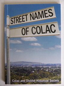
Book, Street Names of Colac, 2008
... plain in the world and European settlement began in 1837. The book was commenced by Ian McIntosh in the 1970s and in 2005 the Colac and District Historical Society took on the project again with the major editors being Ida and Andrew McIntosh. This book is of interest, particularly those in the Western ...This is a book giving information on the streets of Colac and the origins of the names. Colac is a city 150 kilometres south west of Melbourne and is a commercial centre for a major agricultural area. It is situated near the 3rd largest volcanic plain in the world and European settlement began in 1837. The book was commenced by Ian McIntosh in the 1970s and in 2005 the Colac and District Historical Society took on the project again with the major editors being Ida and Andrew McIntosh. This book is of interest, particularly those in the Western District of Victoria, as it contains information on Colac streets, many of which were named after pioneers of the district. The book will be useful for research. This is a soft cover book of 60 pages. The cover has a blue background and features a colour photograph (mainly in green, blue and white tonings) of a panorama of the Colac district. The photograph extends over the front and back covers. The book contains the names and name origins of Colac streets in alphabetical order and many black and white photographs. The pages have a glued binding. Front Cover: ‘Street Names of Colac’ ‘Colac and District Historical Society’ history of colac, colac and district historical society, street names of colac, ian mcintosh -
 Warrnambool and District Historical Society Inc.
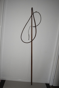
Whip, Bullock Whip, Early 20th century
... Bullocks and Bullockies in the Western District Warrnambool history of warrnambool This is a wooden stick, slightly tapered to the top, with a leather binding at the top with a small knob. Attached to the top of the stick is a whip made of plaited leather. The leather is brown and stained and slightly worn. At the end of the whip is a strip of plain ...Bullock teams and bullockies were common sights in Australia in the 19th and early 20th centuries. Bullock teams were used for the transport of heavy goods such as wool, wheat, timber, sugar cane, farm equipment, building supplies etc. and their presence and that of their colourful bullock drivers in the countryside have become part of Australia bush folklore. Bullocks were often favoured over horses as they could pull heavy loads over rough surfaces and were less expensive to maintain. As the bullock teams frequently varied in size (up to 40 bullocks have been recorded in the one team) the whip was always a very long one. This item is of considerable significance as a memento of the days (19th century and early 20th century) when bullock teams were the common form of transport for heavy goods. As in other parts of Australia, bullock teams were a feature of the area around Warrnambool and created much interest when they arrived in the smaller towns. This is a wooden stick, slightly tapered to the top, with a leather binding at the top with a small knob. Attached to the top of the stick is a whip made of plaited leather. The leather is brown and stained and slightly worn. At the end of the whip is a strip of plain leather with a knot at the end. bullocks and bullockies in the western district, warrnambool, history of warrnambool