Showing 7 items matching "55 rattray road montmorency"
-
 Eltham District Historical Society Inc
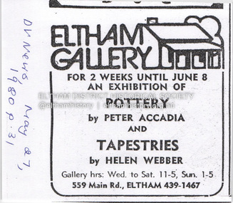
Document - Property Binder, 559 Main Road, Eltham
... ...55 Rattray Road Montmorency...Main Road Property Businesses Eltham Gallery Wiregrass Gallery Eltham Gateway Action Group Robert Marshall Mud brick building Eltham (Vic) 559 Main Road Eltham Artists Bernhard Rust Bob Smith Jan Neil John Adams Marian Sussex Michael Wilson Tony Dopheide 47-55 Main Street Diamond Creek 50 Were Street Montmorency 55 Rattray Road Montmorency 410 Main Road Lower Plenty Abbey of Diamond Creek Adams North Riding Restaurant Advertising Eltham Barrel Montmorency Mustard Seed Restaurant Peking House Restaurant St Andrews Tamara's Miscellaneous clippings, notes, photocopies, etc held on the subject property. 559 Main Road, Eltham Document Property Binder ...Newspaper advertisement: Diamond Valley News, 27 May 1980, Exhibition, Peter Accadia, pottery, and Helen Webber, tapestries. Newspaper article: Five for the price of one, Diamond Valley News, Tuesday, July 8, 1986, p27; exhibition of five artists at Eltham Gallery. On reverse, numerous advertisements for food and entertainment Newspaper advertisement: The Age ,17 June 1989, Exhibition, Donald Ramsay "Watching the river flow". Newspaper article: Landmark gallery says goodbye, Diamond Valley Leader, 24 November 2004, Gallery site sold to Sentinel Equities, present tenant Julie Skate, quotes from former part-owner Val Murray. Newspaper article: Rift over gallery plans, Diamond Valley Leader, 21 February 2007, purchasers Jethro Tull and Suzanne Still plan to build offices, gallery and cafe; Eltham Gateway Action Group objected while supporting need for a gallery elsewhere. Newspaper article: New try for gallery-cafe ready soon, Diamond Valley Leader, 18 April 2007, purchaser Jethro Tull to have a new plan ready in two weeks for gallery and cafe. Newspaper article: Gateway for artists, Diamond Valley Leader, 25 May 2007, Jenni Mitchell opened a new gallery pending decision by Nillumbik Council. Newspaper article: Art gallery proposal rejected, Diamond Valley Leader, 30 May 2007, Nillumbik Council against planned new building. Newspaper article: Artful win for gallery, Diamond Valley Leader, 30 January 2008, VCAT approved mudbrick art gallery. Newspaper article: Rocky road to create a landmark, Diamond Valley Leader, 13 February 2008, VCAT approved Robert Marshall's design, artists's impression, Eltham Gateway Action Group opposed.main road, property, businesses, eltham gallery, wiregrass gallery, eltham gateway action group, robert marshall, mud brick building, eltham (vic), 559 main road eltham, artists, bernhard rust, bob smith, jan neil, john adams, marian sussex, michael wilson, tony dopheide, 47-55 main street diamond creek, 50 were street montmorency, 55 rattray road montmorency, 410 main road lower plenty, abbey of diamond creek, adams north riding restaurant, advertising, eltham barrel, montmorency, mustard seed restaurant, peking house restaurant, st andrews, tamara's -
 Eltham District Historical Society Inc
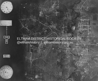
Photograph - Aerial Photograph, Landata, Eltham and Montmorency, Nov. 1931
... Eltham District Historical Society Inc 728 Main Rd Eltham melbourne Centred over present-day Belmont Reserve, Montmorency Historic Aerial Imagery Source: Landata.vic.gov.au Aerial Photo Details: Project No :1931 Project : MALDON PRISON Run : 19 Frame : 3130 Date : 11/1931 Film Type : B/W Camera : F8 Flying Height : 11000 Scale : 18860 Film Number : 60 GDA2020 : 37°43'13"S, 145°07'54"E MGA2020 : 335330, 5823576 (55) Melways : 21 F6 (ed. 42) Aerial Photo Eltham Neil Webster Collection Belmont Reserve Montmorency Rattray Road Digital tif and electronic PDF file Eltham and Montmorency Photograph Aerial Photograph Landata ...Centred over present-day Belmont Reserve, Montmorency Historic Aerial Imagery Source: Landata.vic.gov.au Aerial Photo Details: Project No :1931 Project : MALDON PRISON Run : 19 Frame : 3130 Date : 11/1931 Film Type : B/W Camera : F8 Flying Height : 11000 Scale : 18860 Film Number : 60 GDA2020 : 37°43'13"S, 145°07'54"E MGA2020 : 335330, 5823576 (55) Melways : 21 F6 (ed. 42)aerial photo, eltham, neil webster collection, belmont reserve, montmorency, rattray road -
 Eltham District Historical Society Inc
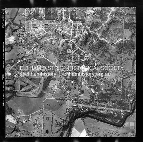
Photograph - Aerial Photograph, Landata, Eltham, Vic, Apr. 1963
... Rattray Road to west. Historic Aerial Imagery Source: Landata.vic.gov.au Aerial Photo Details: Project No :486 Project : MELBOURNE (1963) PROJECT Run : 6 Frame : 124 Date : 04/1963 Film Type : B/W Camera : RC8 Flying Height : 5100 Scale : 9600 Film Number : 1805 GDA2020 : 37°43'12"S, 145°08'16"E MGA2020 : 335876, 5823604 (55) Melways : 21 G6 (ed. 42) Aerial Photo Neil Webster Collection 1963-04 Bible Street Bolton Street Eltham Eltham Ridge Main Road Montmorency Rattray Road Reichelt Avenue Digital jpg and electronic PDF file Eltham, Vic. ...Centred on present day Eltham Ridge, Bolton Street, Eltham bounded by Elsa Court to north, Main Road to south, Bible Street to east and Reichelt Avenue and Rattray Road to west. Historic Aerial Imagery Source: Landata.vic.gov.au Aerial Photo Details: Project No :486 Project : MELBOURNE (1963) PROJECT Run : 6 Frame : 124 Date : 04/1963 Film Type : B/W Camera : RC8 Flying Height : 5100 Scale : 9600 Film Number : 1805 GDA2020 : 37°43'12"S, 145°08'16"E MGA2020 : 335876, 5823604 (55) Melways : 21 G6 (ed. 42)aerial photo, neil webster collection, 1963-04, bible street, bolton street, eltham, eltham ridge, main road, montmorency, rattray road, reichelt avenue -
 Eltham District Historical Society Inc
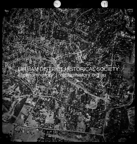
Photograph - Aerial Photograph, Landata, Montmorency / Lower Plenty, 28 Jan. 1946
... Montmorency bounded by Rattray Road to north, Main Road, Lower Plenty to south, Bolton Street to east and Looker Road to west. Historic Aerial Imagery Source: Landata.vic.gov.au Aerial Photo Details: Project No :5 Project : MELBOURNE AND METROPOLITAN AREA PROJECT Run : 34 Frame : 61778 Date : 12/1945 (28.1.46) Film Type : B/W Camera : EAG4 Flying Height : 10200 Scale : 6000 Film Number : 212 GDA2020 : 37°43'30"S, 145°07'37"E MGA2020 : 334934, 5823043 (55) Melways : 21 E8 (ed. 42)...Montmorency bounded by Rattray Road to north, Main Road, Lower Plenty to south, Bolton Street to east and Looker Road to west. Historic Aerial Imagery Source: Landata.vic.gov.au Aerial Photo Details: Project No :5 Project : MELBOURNE AND METROPOLITAN AREA PROJECT Run : 34 Frame : 61778 Date : 12/1945 (28.1.46) Film Type : B/W Camera : EAG4 Flying Height : 10200 Scale : 6000 Film Number : 212 GDA2020 : 37°43'30"S, 145°07'37"E MGA2020 : 334934, 5823043 (55) Melways : 21 E8 (ed. 42) Aerial Photo Bolton Steet Looker Road Lower Plenty Main Road Montmorency Phoebe Mason Collection Rattray Road Electronic PDF file Montmorency / Lower Plenty Photograph Aerial Photograph Landata ...Centred on 32 Grand Boulevard, Montmorency bounded by Rattray Road to north, Main Road, Lower Plenty to south, Bolton Street to east and Looker Road to west. Historic Aerial Imagery Source: Landata.vic.gov.au Aerial Photo Details: Project No :5 Project : MELBOURNE AND METROPOLITAN AREA PROJECT Run : 34 Frame : 61778 Date : 12/1945 (28.1.46) Film Type : B/W Camera : EAG4 Flying Height : 10200 Scale : 6000 Film Number : 212 GDA2020 : 37°43'30"S, 145°07'37"E MGA2020 : 334934, 5823043 (55) Melways : 21 E8 (ed. 42)aerial photo, bolton steet, looker road, lower plenty, main road, montmorency, phoebe mason collection, rattray road -
 Eltham District Historical Society Inc
Photograph - Aerial Photograph, Landata, Montmorency / Lower Plenty, Feb. 1956
... Rattray Road to north, Yarra River to south, Bolton Street to east and Heidelberg Golf Club to west. Historic Aerial Imagery Source: Landata.vic.gov.au Aerial Photo Details: Project No : 250 Project : MELBOURNE OUTER SUBURBS PROJECT Run : 16A Frame : 53 Date : 02/1956 Film Type : B/W Camera : EAG9 Flying Height : 10000 Scale : 12000 Film Number : 1187 GDA2020 : 37°43'47"S, 145°07'25"E MGA2020 : 334645, 5822519 (55) Melways : 21 D9 (ed. 42) Aerial Photo Lower Plenty Main Road Montmorency Phoebe Mason Collection Bolton Steet Heidelberg Golf Club Rattray Road Electronic PDF file Montmorency / Lower Plenty Photograph Aerial Photograph Landata ...Centred on 20 Panorama Avenue, Lower Plenty bounded by Rattray Road to north, Yarra River to south, Bolton Street to east and Heidelberg Golf Club to west. Historic Aerial Imagery Source: Landata.vic.gov.au Aerial Photo Details: Project No : 250 Project : MELBOURNE OUTER SUBURBS PROJECT Run : 16A Frame : 53 Date : 02/1956 Film Type : B/W Camera : EAG9 Flying Height : 10000 Scale : 12000 Film Number : 1187 GDA2020 : 37°43'47"S, 145°07'25"E MGA2020 : 334645, 5822519 (55) Melways : 21 D9 (ed. 42)aerial photo, lower plenty, main road, montmorency, phoebe mason collection, bolton steet, heidelberg golf club, rattray road -
 Eltham District Historical Society Inc
Photograph - Aerial Photograph, Landata, Montmorency / Lower Plenty, Nov. 1975
... Rattray Road, Montmorency to north, Rosehill Road to south, Falkiner Street to east and Lower Plenty shops to west. Historic Aerial Imagery Source: Landata.vic.gov.au Aerial Photo Details: Project No :1243 Project : (ALSO A.P. 1227) Run : 24A Frame : 146 Date : 11/1975 Film Type : B/W Camera : RC8 Flying Height : 5000 Scale : 10000 Film Number : 2722 GDA2020 : 37°43'40"S, 145°07'32"E MGA2020 : 334820, 5822743 (55) Melways : 21 D8 (ed. 42)...Rattray Road, Montmorency to north, Rosehill Road to south, Falkiner Street to east and Lower Plenty shops to west. Historic Aerial Imagery Source: Landata.vic.gov.au Aerial Photo Details: Project No :1243 Project : (ALSO A.P. 1227) Run : 24A Frame : 146 Date : 11/1975 Film Type : B/W Camera : RC8 Flying Height : 5000 Scale : 10000 Film Number : 2722 GDA2020 : 37°43'40"S, 145°07'32"E MGA2020 : 334820, 5822743 (55) Melways : 21 D8 (ed. 42) Aerial Photo Lower Plenty Main Road Montmorency Phoebe Mason Collection Eltham Lower Park Falkiner Street Lower Plenty Shops Rattray Road Rosehill Road Electronic PDF file Montmorency / Lower Plenty Photograph Aerial Photograph Landata ...Centred on 328 Main Road, Lower Plenty bounded by Rattray Road, Montmorency to north, Rosehill Road to south, Falkiner Street to east and Lower Plenty shops to west. Historic Aerial Imagery Source: Landata.vic.gov.au Aerial Photo Details: Project No :1243 Project : (ALSO A.P. 1227) Run : 24A Frame : 146 Date : 11/1975 Film Type : B/W Camera : RC8 Flying Height : 5000 Scale : 10000 Film Number : 2722 GDA2020 : 37°43'40"S, 145°07'32"E MGA2020 : 334820, 5822743 (55) Melways : 21 D8 (ed. 42)aerial photo, lower plenty, main road, montmorency, phoebe mason collection, eltham lower park, falkiner street, lower plenty shops, rattray road, rosehill road -
 Eltham District Historical Society Inc
Photograph - Aerial Photograph, Landata, Montmorency / Lower Plenty, Mar. 1987
... Rattray Road, Montmorency to north, Yarra River to south, Falkiner Street, Eltham to east and Lower Plenty shops to west. Historic Aerial Imagery Source: Landata.vic.gov.au Aerial Photo Details: Project No :1716 Project : WESTERN PORT FORESHORES Run : 16 Frame : 132 Date : 03/1987 Film Type : B/W Camera : RC10 Flying Height : 5600 Scale : 10000 Film Number : 4102 GDA2020 : 37°43'51"S, 145°07'38"E MGA2020 : 334968, 5822406 (55) Melways : 21 E9 (ed. 42)...Rattray Road, Montmorency to north, Yarra River to south, Falkiner Street, Eltham to east and Lower Plenty shops to west. Historic Aerial Imagery Source: Landata.vic.gov.au Aerial Photo Details: Project No :1716 Project : WESTERN PORT FORESHORES Run : 16 Frame : 132 Date : 03/1987 Film Type : B/W Camera : RC10 Flying Height : 5600 Scale : 10000 Film Number : 4102 GDA2020 : 37°43'51"S, 145°07'38"E MGA2020 : 334968, 5822406 (55) Melways : 21 E9 (ed. 42) Aerial Photo Lower Plenty Main Road Montmorency Phoebe Mason Collection Eltham Eltham Lower Park Falkiner Street Lower Plenty Shops Main Road Eltham Rattray Road Yarra River Electronic PDF file Montmorency / Lower Plenty Photograph Aerial Photograph Landata ...Centred on 354-356 Main Road, Lower Plenty bounded by Rattray Road, Montmorency to north, Yarra River to south, Falkiner Street, Eltham to east and Lower Plenty shops to west. Historic Aerial Imagery Source: Landata.vic.gov.au Aerial Photo Details: Project No :1716 Project : WESTERN PORT FORESHORES Run : 16 Frame : 132 Date : 03/1987 Film Type : B/W Camera : RC10 Flying Height : 5600 Scale : 10000 Film Number : 4102 GDA2020 : 37°43'51"S, 145°07'38"E MGA2020 : 334968, 5822406 (55) Melways : 21 E9 (ed. 42)aerial photo, lower plenty, main road, montmorency, phoebe mason collection, eltham, eltham lower park, falkiner street, lower plenty shops, main road eltham, rattray road, yarra river