Showing 289 items matching "a country heritage"
-
 Eltham District Historical Society Inc
Document - Property Binder, 931 Main Road, Eltham
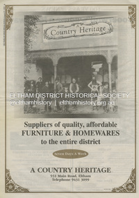
... ...A Country Heritage...Present day location of Nongkhai Thai Eltham restaurant Formerly the location of: Luther Haleys Bakery and General Store (Sep 1902-1917) - Hayley built this store, which was the first store erected in the present-day Eltham shopping district Hannah Lloyd's General Store (1917-c.Feb 1920) Various owners Staff's General Store (c.1939-Feb 1965) then demolished Ray Staff Eltham Big Star Food Centre (c.1965-1967) Eltham Big Star Food Centre (Staffs new building c.1965-1967) A Country Heritage Furniture and Homewares (?-2006) Newspaper advertisement: Leader Associated Newspapers, 100 Years of News Special Edition, August 27, 1997, p6; A Country Heritage Newspaper advertisement: Diamond Valley Leader, 4 September 2006, Closing Down Sale, A Country Heritage In February 1965, Staffs Railway Store, the oldest business premises in the Eltham shopping district was demolished. ...Eltham District Historical Society Inc 728 Main Rd Eltham melbourne Present day location of Nongkhai Thai Eltham restaurant Formerly the location of: Luther Haleys Bakery and General Store (Sep 1902-1917) - Hayley built this store, which was the first store erected in the present-day Eltham shopping district Hannah Lloyd's General Store (1917-c.Feb 1920) Various owners Staff's General Store (c.1939-Feb 1965) then demolished Ray Staff Eltham Big Star Food Centre (c.1965-1967) Eltham Big Star Food Centre (Staffs new building c.1965-1967) A Country Heritage Furniture and Homewares (?-2006) Newspaper advertisement: Leader Associated Newspapers, 100 Years of News Special Edition, August 27, 1997, p6; A Country Heritage Newspaper advertisement: Diamond Valley Leader, 4 September 2006, Closing Down Sale, A Country Heritage In February 1965, Staffs Railway Store, the oldest business premises in the Eltham shopping district was demolished. ...Present day location of Nongkhai Thai Eltham restaurant Formerly the location of: Luther Haleys Bakery and General Store (Sep 1902-1917) - Hayley built this store, which was the first store erected in the present-day Eltham shopping district Hannah Lloyd's General Store (1917-c.Feb 1920) Various owners Staff's General Store (c.1939-Feb 1965) then demolished Ray Staff Eltham Big Star Food Centre (c.1965-1967) Eltham Big Star Food Centre (Staffs new building c.1965-1967) A Country Heritage Furniture and Homewares (?-2006) Newspaper advertisement: Leader Associated Newspapers, 100 Years of News Special Edition, August 27, 1997, p6; A Country Heritage Newspaper advertisement: Diamond Valley Leader, 4 September 2006, Closing Down Sale, A Country Heritage In February 1965, Staffs Railway Store, the oldest business premises in the Eltham shopping district was demolished. Formerly a self-service grocery, restaurant and electrical repair shop, the building for many years housed Eltham’s only ‘family’ grocer and feed store. Earlier it had appeared to have been the town’s bakery. The building had been purchased in late March 1939 by Mr Eric N. Staff. At the time of E.N. Staff’s purchase there were huge bakers’ ovens located at the rear and the building also had a well and four toilets for employees. When the ‘pictures’ came to Eltham with the opening of the Eltham Public Hall across the road in 1941, Mr E.N. Staff extended the business and opened a milk bar and sweet shop. Further extensions re-established the tea rooms of days gone by. Mr E.N. Staff conducted business for about 15 years before handing over the reins to his son, Ray Staff. When his son Ray took over, the milk bar and tea rooms were closed for several years but the milk bar and was later re-opened and subsequently became a greengrocers and later again, a restaurant. The tea rooms section was converted to an electrical repair shop about 1955. Electoral Roll records for 1967 record Raymond Charles Staff at 929 Main Road, Eltham, grocer, and in 1968 at Lot 4, Hillcrest Avenue, Eltham, taxi truck operator. Staff’s store appears to have occupied 929-933 Main Road and the Eltham Big Star Food Centre was centred around 931 Main Road. It would appear that Ray continued to run the business for approximately two years after the original store was demolished and a new supermarket was built. Today, 931 Main Road is the Nongkhai Thai Restaurant and is precisely where the original Staffs store stood. Even though the facade has been modified at eye level with new larger windows, the upper facade is identical to that of the new Eltham Big Star Food Centre of 1965/66. But how did the original building, the oldest premises in the 1965 era shopping centre come about? On August 12th, 1902 at the Eltham Courthouse, appearing before T. Smallman, Esq,. Police Magistrate, and Messrs. W. Duncan and W.J. Taylor, Justices of the Peace is Luther Haley, baker. Wilfred Henry Johnston, by his agent Stanley Ernest Elder had applied for a warrant of ejectment under the Landlord and Tenant Act 1890 against Luther Haley from the bakery premises at the corner of Main Road and York Street. From the evidence presented we learn that Mrs Burgoyne of Eltham had purchased the property some months earlier from Mr Johnston, which consisted of a store and bakery establishment at Eltham occupied by Mr. Luther Haley, and whose lease expired some little time back, and up to the present time, Mr. Haley was not prepared to leave. He informed the court that he is unable to secure at Eltham a suitable house in which to carry on his business, but was building a place near the railway station which he expected to be done in about three weeks time, and he is then prepared to give up possession of the premises he now occupies. Mr Smallman informed the defendant, Luther Haley, that he will have to quit the premises in three weeks from the present date, and that a warrant of ejectment would be issued. However he also informed Mr Haley that he would order the warrant to lie in the office for three weeks from that date. The premises under construction referred to by Luther Haley in court were situated on the western side of Main Road, near the railway station slightly opposite present-day Arthur Street. It was opened around September 1902 as a General Store, Bakery and Tea Rooms. This was the original building in the present-day shopping precinct. At the time the only thing nearby was the railway station. Luther Haley’s business appeared to prosper and he would have catered to not only the locals abut also day visitors by train on Sundays coming up from Melbourne, offering fresh baked produce, tea rooms and summer drinks. The fields across Main Road running between present day Arthur Street and Luck Street were known as Haley’s Paddock and at times were used for community festivities and picnics. A newspaper report on the annual State schools picnic held at Haley’s Paddock on March 11, 1904 described it as “quite close to the railway station, and is quite capable of holding comfortably 10,000 people. With its ample shade and hilly surroundings, it is an ideal place for any gathering.” Luther Haley successfully ran his general store, bakery and tea rooms until 1917 when he and his family departed the district and moved to Westgarth Street in Northcote where he changed careers and became a publisher. It was then taken over by Hannah Lloyd and became known as Lloyd’s Railway General Store from 1917 to 1920. From then it had a succession of owners, one as short as two months until March 31, 1939 when the Grocery Business formerly carried on by Mr. T.K. White of Eltham for the previous eight years was purchased by Mr Eric N. Staff of Research and became known as E.N. Staff’s Railway Store. The ownership timeline for the store is as follows: Luther Haley Sep 1902-1917 Hannah Lloyd 1917-c.Feb 1920 Messrs J.R. & N.E. Lee 1920-Sep 1922 A. & E. Copeland Sep 1922-Sep 1925 Mr Price Sep 1925-Nov 1925 Mr Warren Nov 1925?-Nov 1926 A.W.J. Edwards Nov 1926-1931 T.K. White 1931-Mar 1939 Eric Staff Apr 1939-c.1954 Ray Staff c.1954-Feb 1965 then demolished Ray Staff Eltham Big Star Food Centre c.1965-1967 THROWBACKTHURSDAY: ELTHAM BIG STAR FOOD CENTRE, MAIN ROAD, 1966 https://elthamhistory.wordpress.com/2020/04/16/throwbackthursday-eltham-big-star-food-centre-main-road-1966/eltham, businesses, a country heritage, property, shops, main road eltham, a. copeland, a.w.j. edwards, big star food centre, e. copeland, eric staff, general store, hannah lloyd, j.r. lee, lloyd's general store, luther haley, n.e. lee, price, ray staff, staffs general store, supermarket, t.k. white -
 Glenelg Shire Council Cultural Collection
Newspaper - Newspaper article - Bridgewater Golf Club, Jul-92
... Article headed 'Bridgewater Golf Club' and details proposed Heritage Valley country Club at Cape Bridgewater, as part of the Heritage Valley subdivision....Article headed 'Bridgewater Golf Club' and details proposed Heritage Valley country Club at Cape Bridgewater, as part of the Heritage Valley subdivision. ...Photocopy of article from Portland 'Observer', Friday July 10, 1992, in two halves, not joined together. Article headed 'Bridgewater Golf Club' and details proposed Heritage Valley country Club at Cape Bridgewater, as part of the Heritage Valley subdivision. -
 Kiewa Valley Historical Society
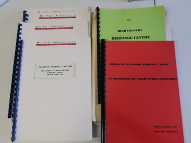
Collection of Papers and Books re - Mt Beauty Heritage Centre
... Heritage Centre - manila folder 4. High Country Heritage Centre - 1991 - green spiral folder 5. ...Heritage Centre - manila folder 4. High Country Heritage Centre - 1991 - green spiral folder 5. ...In the early 1990s the KVHS applied for a grant to create the Mt Beauty Heritage Centre / Discovery Centre. This involved employing consultants and further research.This collection includes a lot of detail of the Kiewa Valley area.1. Bogong - The Alpine Discovery Centre 2. Heritage Centre - black folder 3. Heritage Centre - manila folder 4. High Country Heritage Centre - 1991 - green spiral folder 5. Six Heritage Centre - Matt Viney & Associates - white spiral folders 6. Landscape Consultants - Susan Campbell & son - red spiral folder 7. Plant List - Upper Kiewa Valley Water Supply Catchment 8. Geological Survey of Vic., Plates, Bulletin No. 44 - in battered paper 'bag' with front cover list of contents - 15 plates 9. Geological Survey - A3 photo copies of pages 106-117 10. Geological Survey of Vic. - Report of Progress No VII 1884 - bound book 11. Geological Survey of Vic. Bulletin 56 - includes nth east Vic. 1958 - bound book with green cloth spine 12. Department of Mines Report Vic. 1906 - booklet held with two staples 13. Royal Society of Vic book - The Geology of the Kiewa Area 1961 14. Miscellaneous papers - Geological Survey, Reports of Fossil Specimens and maps of local area 15. Gold - Appendix K and Appendix 111, Part C - photocopied pages from Vic Mining Registrars Report 1888 - manila foldermt beauty heritage centre, mt beauty discovery centre, geological surveys -
 Eltham District Historical Society Inc
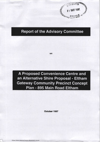
Document - Report, Paul Jerome, Advisory Committee on a Proposed Convenience Centre and an Alternative Shire Proposal - Eltham Gateway Community Precinct Concept Plan - 895 Main Road Eltham, October 1997
... In particular, these policies seek • to conserve and enhance the bushland/country atmosphere, artistic heritage and strong sense of community of the Eltham Town Centre by ensuring that the design and height of any new development is sympathetic to existing buildings • to achieve a pleasing physical environment within the Eltham Town Centre by encouraging a high standard of architecture and urban design • to encourage Improvement to pedestrian amenity through such facilities as open and shattered rest areas and meeting places, crossing facilities, pedestrian arcades, pedestrian links to car parks and pedestrian weather protection • to reduce conflict between vehicular traffic and pedestrian flows, and • to encourage pedestrian thoroughfares It is submitted, as set out In the main body of this report, that the DPP proposal fails substantially to meet these policies and In so doing does not merit the exercise of discretion In Its favour with the Issuing of a permit. ...In particular, these policies seek • to conserve and enhance the bushland/country atmosphere, artistic heritage and strong sense of community of the Eltham Town Centre by ensuring that the design and height of any new development is sympathetic to existing buildings • to achieve a pleasing physical environment within the Eltham Town Centre by encouraging a high standard of architecture and urban design • to encourage Improvement to pedestrian amenity through such facilities as open and shattered rest areas and meeting places, crossing facilities, pedestrian arcades, pedestrian links to car parks and pedestrian weather protection • to reduce conflict between vehicular traffic and pedestrian flows, and • to encourage pedestrian thoroughfares It is submitted, as set out In the main body of this report, that the DPP proposal fails substantially to meet these policies and In so doing does not merit the exercise of discretion In Its favour with the Issuing of a permit. ...On 15 December 1994 the former Shire of Eltham ceased to exist following the Liberal Kennett Government local council amalgamations. A new Nillumbik Shire Council was established with unelected commissioners appointed. That Council sold the former Eltham Shire Council Offices and land at 89S Main Road Eltham to Dallas Price Homes Pty. Ltd. the sale being conditional upon the granting of a planning permit for a petrol station/convenience store, fast food and video outlet. The sale was conditional that if the permit was not granted by 30 August. 1997, the contract could be avoided by either the purchaser or the vendor. The proposed development consisted of a petrol station with undercover fuelling facilities, convenience shopping, a drive through service facility for fast food, an 80 seat cafe, automated banking, a children's play area and retail space. In addition, the proposal included a 200 square metre community facility for Council use, provision of on site carparking over 2 levels for 83 vehicles, and advertising signage. An Advisory Committee consisting of Dimitry Reed and Margaret Pitt was appointed under Section 151 of the Planning and Environment Act 1987 to hear submissions on the proposal to develop the land at 895 Main Road Eltham, the site of the former Eltham Shire Offices. In September 1996, two applications were made by Contour Consultants Australia Pty Ltd on behalf of Dallas Price Homes Ply Ltd, to Nillumbik Shire Council. After extensive notification, the Council received 213 objections and a petition of over 1400 signatures. On October 9, 1996, Nillumbik Shire Council issued Notices of Decision to Grant Permit on Applications number 96/03376 and 96/0377 for the use and development of the land as a convenience Centre consisting of a petrol station, convenience store, cafe/takeaway food premises, a retail facility and a community facility, with associated advertising signs. Objectors to the proposals lodged Planning Appeals number 96/40724 and 96/40812 with the Administrative Appeals Tribunal on November 1, 1996. The grounds of appeal can be summarised as: inappropriate development, insufficient carparking, traffic and access issues, unsatisfactory design, inadequate permit conditions, the proposal being out of character with the area. and being contrary to the purpose and orderly development of the Eltham Town Centre, excessive noise, lack of consultation and unsuitable signage. On November 13, 1996, the Minister for Planning and Local Government directed the Registrar of the Administrative Appeals Tribunal. under Section 41 (1) (a) of the Planning Act 1980, to refer the Appeals to the Governor in Council for determination without a hearing or recommendation by the Tribunal. The Minister for Planning and Local Government called in the Appeals as he considered that they raised major issues of policy relating to the facilitation of development in accordance with the objectives set out in Section 4 of the Planning and Environment Act 1987, and that determination of the Appeals could have a substantial effect on the achievement of these planning objectives. The Minister required the Advisory Committee to consider the planning merits of the proposed use and development, and to address the issues raised in the objections. The Advisory Committee was required to produce a report providing: • The Committee's response to the matters detailed; • Relevant supporting information for the Advisory Committee's recommendation; and • A description of the proceedings conducted by the Advisory Committee and a list of those consulted or heard by the Committee. In March 1997, elections were held in the Shire of Nillumbik and the view of the new Council to this proposal differed from the view held by the earlier Council Hence the Submission made to the Committee by the Shire was against the decision by the Shire of Nillumbik to issue the Notices of Decision to Grant a Permit. The Recommendations of the Advisory Committee were: i. The cafe and take away food premises are as of right uses and are therefore allowable, but that shop and petrol station are unacceptable uses. A community facility is a discretionary use and is acceptable. ii. A development of the type and scale proposed is totally inappropriate for this land and that the Applications number 96/03376 and 96/0377 for the use and development of the land as a convenience Centre consisting of a petrol station, convenience store, café/takeaway food premises, a retail facility and a community facility, with associated advertising signs, be refused. iii. The land should be rezoned for public purposes and should remain in the community's ownership for community use. Following this, the Minister for Planning and Local Government, the Hon. Robert Maclellan, appointed Mr. Paul Jerome as an Advisory Committee under section 151 of the Planning and Environment Act 1987 to consider a Convenience Centre and an alternative proposal by Iha Shire of Nillumbik being the Eltham Gateway Community Precinct Concept Plan for the site of the former Shire of Eltham municipal offices at 895 Main Road, Eltham. In summary, the terms of reference for the Advisory Committee required it to: • consider the merits of the Council proposal • examine the merits of both proposals in terms of net community benefit • address the report of the previous Advisory Committee on the Convenience Centre proposal The Advisory Committee inspected the site and considered all the material before It including submissions made by all parties to the previous Advisory Committee and correspondence received by the Department of Infrastructure both before and after that Committee submltted its report. The Advisory Committee also held discussions with the following people: • Cr. Robert Marshall • Cr. Margaret Jennings • Cr. Lex de Man • Mr. Dallas Howgate of Dallas Price Properties, also Dallas Price Homes • Mr. Barry Rochford, CEO, Shire of Nillumbik • Ms. Yvonne Rust, Planning Officer, Shire of Nillumbik • Mr. Gregory Burgess, Architect of the Eltham Library and of Council’s Community Precinct Concept Plan • Mr. Jim Connor representing Mrs Thelma Barkway of the Eltham Senior Citizens Club Having considered all the material before it, the Committee arrived at two basic conclusions. First, the DPP proposal should be rejected because, on its merits, It does not sufficiently satisfy the requirements of the planning scheme which is a statutory document. The planning scheme requires that, before making a decision on the permit applications for the DPP proposal, a range of matters must be considered. It follows that consideration of these matters should Influence the decision. These matters include local policies relating to character and amenity. In particular, these policies seek • to conserve and enhance the bushland/country atmosphere, artistic heritage and strong sense of community of the Eltham Town Centre by ensuring that the design and height of any new development is sympathetic to existing buildings • to achieve a pleasing physical environment within the Eltham Town Centre by encouraging a high standard of architecture and urban design • to encourage Improvement to pedestrian amenity through such facilities as open and shattered rest areas and meeting places, crossing facilities, pedestrian arcades, pedestrian links to car parks and pedestrian weather protection • to reduce conflict between vehicular traffic and pedestrian flows, and • to encourage pedestrian thoroughfares It is submitted, as set out In the main body of this report, that the DPP proposal fails substantially to meet these policies and In so doing does not merit the exercise of discretion In Its favour with the Issuing of a permit. This finding is not offset by the investment and employment attributes of the proposal. They do not override the need to comply with the planning scheme. Second, the Council proposal, on Its own merits, substantially meets all statutory requirements applicable to this site with a possible reservation about car parking and traffic management which need further definition and assessment as the concept is refined. The Council proposal, however, has a serious weakness in that Its financial viability has not been adequately tested. The Committee refers to 'financial' rather than 'commercial' viability in recognition that Council owns the land and may enter into a range of agreements and partnerships to realise its concept some of which may be truly commercial and some of which may involve an element of subsidy arising from Council's involvement as a public body acting on behalf of its community. The Committee concludes that Council should be given the opportunity, within a reasonable timeframe to establish the financial feasibility of its concept and should develop a strategy for the future of Its land asset at 895 Main Road in the event that Its concept for the site cannot be realised. 895 main road, advisory committee, dallas price homes, eltham, eltham shire office, nillumbik shire council, planning application, administrative appeals tribunal -
 Warrnambool and District Historical Society Inc.
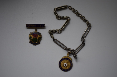
medal, 1 Newman .2 Stokes, Warrnambool & District Caledonian Society, Mid 20th century
... This group is dedicated to preserving and promoting Scottish heritage in the local area and sponsors Scottish country dancing and Highland dancing. ...This group is dedicated to preserving and promoting Scottish heritage in the local area and sponsors Scottish country dancing and Highland dancing. ...These medals have been issued to members of the Warrnambool and District Caledonian Society (one to a committee member). This group is dedicated to preserving and promoting Scottish heritage in the local area and sponsors Scottish country dancing and Highland dancing. The group has its origins in the establishment in Warrnambool of the Western Caledonian Society in 1864 and annual Highland Gatherings were held in the district for many decades after this. These medals, artistically-pleasing ones, are of interest as mementoes of a long- established society in Warrnambool – the Warrnambool & District Caledonian Society. .1 aA gold-coloured medal with gold lettering within a blue circle, a thistle image at the top of the medal and an image in the centre of a coat of arms surrounding an enamelled shield. The medal is attached by a metal clip to a metal chain. .2 A medal in the shape of a shield with gold lettering and images of a thistle and leaves in green and maroon colouring set against a gold background. The medal has a metal bar attached to the top and this bar has a metal clip at the back. .1 Warrnambool & District Caledonian Society In Defence Nemo Me Impune Lacessit Newman .2 Warrnambool & District Caledonian Soc. Committee Stokes warrnambool & district caledonian society, history of warrnambool, warrnambool and district caledonian society, scottish country dancing and highland dancing -
 Warrnambool and District Historical Society Inc.
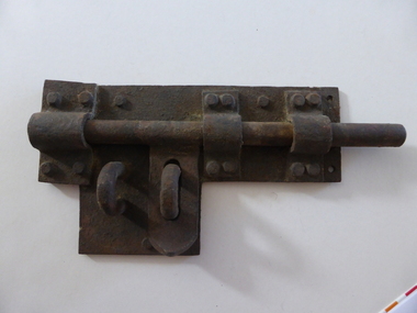
Artefact, Old gaol lock, c.1880
... heritage buildings which comprise a police station, a police residence, police stables as well as the gaol. These were built between 1883 and 1888 from the designs of the Victorian Public Works Department architect, E.R. Laver. He was responsible for the designs of many 19th century country...heritage buildings which comprise a police station, a police residence, police stables as well as the gaol. These were built between 1883 and 1888 from the designs of the Victorian Public Works Department architect, E.R. Laver. He was responsible for the designs of many 19th century country ...This lock was once used in the old 19th century gaol in Gilles Street, Warrnambool. The gaol is part of a group of four heritage buildings which comprise a police station, a police residence, police stables as well as the gaol. These were built between 1883 and 1888 from the designs of the Victorian Public Works Department architect, E.R. Laver. He was responsible for the designs of many 19th century country police stations, post offices and courthouses in Victoria. The four heritage buildings, of which the gaol is one, are important because they are some of the few surviving Warrnambool 19th century bluestone buildings. Today they form part of the South West Tafe Complex. This lock is of considerable interest as one used in the Warrnambool 19th century gaol building. The door on which it was used appears to be walled up now. This is a large iron lock with a base plate with three rivets and a projection piece. There are three curved iron pieces on the plate and these are fixed to the plate with 12 rivets. The bolt is rounded and moves under the three curved pieces across the plate. There are two other curved pieces, part of the bolt locking system. The lock has surface rust. warrnambool police and gaol heritage buildings, history of warrnambool -
 Kiewa Valley Historical Society
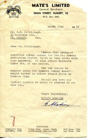
Photograph - Mt Beauty Community Centre original colour plan and photos of upgrade in 2000, 1. Dated March 22nd, 1962 2. Photographs taken during renovations in 2000
... Kiewa Valley Historical Society Mount Beauty Information Centre 31 Bogong High Plains Rd Mt Beauty high-country The Community Centre was built in the early 1950’s as an all-purpose hall for the social and recreational use of the workers and families employed on the Victorian state government Kiewa Hydro-electric scheme. The hall was originally called Mt Beauty Recreation Centre and later changed to Mt Beauty Community Centre. It has been the heart of the community for over 65 years and had a heritage ...The Community Centre was built in the early 1950’s as an all-purpose hall for the social and recreational use of the workers and families employed on the Victorian state government Kiewa Hydro-electric scheme. The hall was originally called Mt Beauty Recreation Centre and later changed to Mt Beauty Community Centre. It has been the heart of the community for over 65 years and had a heritage listing put on it around the year 2000. The Alpine Shire secured a heritage grant and the hall was restored to its former glory in 2000. In heritage circles it is claimed that the hall is the best example of a 1950’s construction town community hall, which is still functioning anywhere in AustraliaThe Community Centre was and is a very important part of life in the small remote community of Mount Beauty and a range of activities have taken place in the Community Centre over the past 65 years- Picture theatre; Dances and balls; A physical education and boxing club run by Alex McCollough for 30 years; School and social club concerts; Girls gymnastics; Drama group productions, revues and pantomimes; Callisthetics and ballet; Badminton; Wedding receptions and birthday parties; Music festival events; Staging area in times of natural disaster; The library for many years; Shire and community meetings; Secondary College gymnasium for many years and shelter for the Community Market in inclement weather 1 – 1972 specifications for colour scheme of original Mt Beauty Recreation centre, Typed on buff foolscap paper with small colour swatches and letter of explanation to Mr A.J. McCullough. 2 – Set of 10 colour photographs of the upgrade and extension to Mt Beauty Community Centre undertaken in 2000. Photos mounted 2 to a page on blue copy paper. 3. Second copy of No.1 above. Also - typed A4 sheet re history of "The Mount Beauty Community Centre"1 – Header on pages-Mate’s Colour Bar Personal Colour Scheme for Recreation Centre Mt Beauty Vic. 21/3/62. Accompanying letter to A.J McCullough signed by Colour Consultant Ena Chatuein 2. First page of photos, written in black felt marker – Mt Beauty Community Centre 30/11/00 mt beauty, community centre -
 Kiewa Valley Historical Society
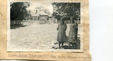
Photographs x 2- Khancoban Station and Comet the horse
... Khancoban lies in the heart of the high country and is home of Australia’s mountain cattlemen. This heritage is celebrated in Banjo Paterson’s epic poem, “The Man from Snowy River”. ...Khancoban lies in the heart of the high country and is home of Australia’s mountain cattlemen. This heritage is celebrated in Banjo Paterson’s epic poem, “The Man from Snowy River”. ...In 1824, Hume and Hovell were the first Europeans to pass through the district and graziers soon followed, impressed by the abundance of fodder and water. The first cattle run in the area was settled in about 1838 in what was known as Swampy Plains. Later, this run became known as “Khancoban Station”. Khancoban lies in the heart of the high country and is home of Australia’s mountain cattlemen. This heritage is celebrated in Banjo Paterson’s epic poem, “The Man from Snowy River”. In 1962, Bruce and Jo Chisholm relocated from Bond Springs to Khancoban Station, which Bruce had acquired in 1959. Khancoban Hereford and thoroughbred stud progeny were keenly sought after whenever they were presented in the sale ring. Bruce imported a stallion, Comet, from England in 1964. Comet stood at Khancoban for 15 years and was the sire of numerous winners, including Cobbermine, Kelly's Eye, Boack and Starglow. Photographs demonstrate local Kiewa Valley residents enjoying a community visit to the historic homestead at Khancoban Station which holds significance to the early history of the area. Its heritage is celebrated in Banjo Paterson’s epic poem, “The Man from Snowy River”. Also demonstrates a pictorial history of social activities undertaken during this period Black and white photographs mounted on buff card 1. Kiewa Valley residents visiting Khancoban Station 2. Photo of thoroughbred horse Comet and handler at Khancoban Station1. Handwritten in black ink below photo- Khancoban Station. Mrs. Young, Mrs Van Der Weyde 2. Handwritten in black ink above photo- "Comet' at Khancobankiewa valley residents, clare roper -
 Kiewa Valley Historical Society
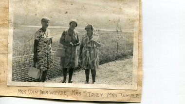
Photographs x 2- Groups of Kiewa Valley residents on tour of Khancoban area
... country Demonstrates a pictorial history of social activities undertaken by Kiewa Valley residents during this period possibly 1970’s to 1980’s. Also a pictorial record of residents of the Kiewa Valley during this period. Photographs demonstrate local Kiewa Valley residents enjoying a community visit to the Khancoban area, which holds significance to the early history of the district. Its heritage ...Demonstrates a pictorial history of social activities undertaken by Kiewa Valley residents during this period possibly 1970’s to 1980’s. Also a pictorial record of residents of the Kiewa Valley during this period. Photographs demonstrate local Kiewa Valley residents enjoying a community visit to the Khancoban area, which holds significance to the early history of the district. Its heritage is celebrated in Banjo Paterson’s epic poem, “The Man from Snowy River”. 2 black and white photographs mounted on buff card. 1. Group of ladies on a tour of the Khancoban area 2. Mixed group of ladies and men on a tour of the Khancoban area 1. Handwritten in black ink below photo 'Mrs Van Der Weyde, Mrs Storey, Mrs Temple 2. Handwritten in black pen below photo 'A.O. Smith, A. Angus, Mrs. Pullin, S. Ross, C. Roper, Mrs Temple, A. E. Campbell (name of last person obscured)kiewa valley residents, clare roper -
 Kiewa Valley Historical Society
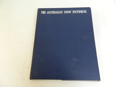
Book - Miscellaneous - Pictorial - Snow, Georgian House, The Australian Snow Pictorial, c1952
... country This book records the history of skiing in Victoria with photos of places and people showing equipment used in the snow fields and used by skiers. Falls Creek and the Bogong High Plains are included in this book showing photos of local people and machinery etc. Dorothy Anderson (nee Ryder) owned and used this book. She lived at Tawonga. snow skiing photography pioneers enthusiasts heritage ...This book records the history of skiing in Victoria with photos of places and people showing equipment used in the snow fields and used by skiers.Falls Creek and the Bogong High Plains are included in this book showing photos of local people and machinery etc. Dorothy Anderson (nee Ryder) owned and used this book. She lived at Tawonga.This is a bound pictorial book with a blue cover and white printed title.. The subject is Alpine resorts and ski areas in the Australian High Country in the 40s and 50s. 'To our very dear friends, Mr and Mrs Ryder, with our best wishes for a Merry Christmas & a Happy New Year from Harold and 'Rel / Ril ?' 'snow, skiing, photography, pioneers, enthusiasts, heritage, st elmo, secv machinery, ryder family, bogong high plains, rope tow -
 Kiewa Valley Historical Society
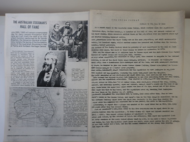
Papers - Roper Family, The Australian Stockman's Hall of Fame
... country The Australian Stockman's Hall of Fame is a museum located in Longreach, Queensland, Australia, which pays tribute to pioneers of the Australian outback. The centre is also dedicated to Australian stockmen who have shown bravery and courage. Registered in 1974. On July 28th 1985 the foundation stone of the Australian Stockman's Hall of Fame and Outback Heritage ...The Australian Stockman's Hall of Fame is a museum located in Longreach, Queensland, Australia, which pays tribute to pioneers of the Australian outback. The centre is also dedicated to Australian stockmen who have shown bravery and courage. Registered in 1974. On July 28th 1985 the foundation stone of the Australian Stockman's Hall of Fame and Outback Heritage Centre was laid. Hoofs and Horns magazine was established by R.M.Williams in 1944 and ceased in 2005. It was aimed at cattlemen and horsemen.'The Roper family's ancestors settled in the beautiful Kiewa Valley, Victoria over a century ago and started breeding Hereford cattle and horses.' This is their interest in Hoofs and Horns but the Hall of Fame is interested in 'John Roper, who came to Australia in 1843 at the age of 23 years and joined Leichhardt's expedition ...'2 papers - Hoofs and Horns, July 1985, Page 88 and page 90 printed with photos and map. The article has the title: 'The Australian Stockman's Hall of Fame' 2 papers - Title The Roper Family compiled by Wilma Davies (nee Roper) and Mr Mike Cummings. Members of the Hall of Fame.. australian stockman's hall of flame, hoofs and horns magazine, cattlemen and horsemen, the roper family -
 Kiewa Valley Historical Society
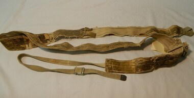
Seal Skins Ski Straps / Soles, mid 1900's
... country These seal skin straps and webbing were introduced into the Victorian Alps by European engineers, conducting survey work for the SEC Hydro scheme in the late 1930s. This period in time produced many immigrants from a war torn Europe with highly developed technical skills. Many of these immigrants provided articles that were well suited to the alpine regions of Australia, ones they used in their homelands. These were times when the home grown cultures of the Anglo Saxon heritage ...These seal skin straps and webbing were introduced into the Victorian Alps by European engineers, conducting survey work for the SEC Hydro scheme in the late 1930s. This period in time produced many immigrants from a war torn Europe with highly developed technical skills. Many of these immigrants provided articles that were well suited to the alpine regions of Australia, ones they used in their homelands. These were times when the home grown cultures of the Anglo Saxon heritage of the earlier settlers within the Kiewa Valley became interwoven with the various European cultures and this formed, what in later years became the beginning of the Australian multi-cultural society. The Kiewa Valley and its surrounding regions where the major rural areas which did not progress in a so typical Aussie "dinky-di", "she'll be right" fashion. The European influence was however not too strong, so as to obliterate the flavour of the home grown rural society.The major populated sections of the upper Kiewa Valley and the Alpine regions were accelerated by the SEC Hydro Development which brought into the slow growing rural regions a quasi multi ethnic society, however this was only noticeable up to the time when the final Power Station was commissioned in the 1960s. The slight variations to the typical Australian rural settlements of the time were in some food preparations, winter apparel such as these seal skin straps and soles and "langlauf" (cross-country skis). The sealskins were sewn so that their grain ran from front to back thereby allowing the skins to grip going up hill and glide going downhill.The gardens and varieties of flowering shrubs and trees where also more in line with traditional European "outdoor" settings. Seal skin sewn onto one side of a strap of webbing. There is a webbing loop on the front that slips over a small point at the front of the ski. There is a webbing strap attached to the back of the seal skin sole coming over the back of ski that clips metal fasteners onto a loop of webbing behind the ski boot. alpine sports, snow skis, winter clothing, mount bogong recreational activities, snow sports -
 Kiewa Valley Historical Society
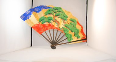
Fan Personal, circa 1920's
... Kiewa Valley Historical Society Mount Beauty Information Centre 31 Bogong High Plains Rd Mt Beauty high-country Personal fan of Asian origin used by early immigrant family living in Kiewa Valley and indicative of the mixed heritages within the Valley. ...Personal fan of Asian origin used by early immigrant family living in Kiewa Valley and indicative of the mixed heritages within the Valley. Personal Fan of vintage circa 1920s suggests middle to upper socio-economic levelHistorically this item places certain ethnic group in the Kiewa Valley circa 1920's - 1950's. This personal fan indicates that it may have belonged to a middle class person with greater leisure time than that of a working class. The multicultural fabric of the region is also highlighted.Personal hand fan (slide out sideways open). Cardboard screen on wooden spine frame. Main side bright coloured green trees on golden red and royal blue background. Wispy silver lined clouds, black branches and brown earth with moss. Flip side gold speckled on white background Bamboo like sliversfan, personal fan, cooling, oriental, hand fan -
 Kiewa Valley Historical Society
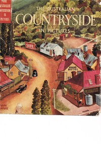
Book - Reference Countryside, The Australian Countryside in Pictures, circa 1950s
... The strong heritage link to this region of many families still residing within its boundaries, is a clear affirmation of the bond that the Kiewa Valley and its Regions have upon family unity. This unity within the rural environment is something that is attracting more and more families from sometimes alienating city life. country life australian "outback" rural industries life on the land swag-man of the bush On the tittle page is a signature "C Roper" This printed coloured sketched, or painted paper sleeve of the book is freely wrapped over a dark red hard cover. ...This book is a "snapshot" in time (1950s) detailing life in Australia covering a time when a "man's word and handshake" were his moral and quasi legal bond, and the now relative defunct saying "smoko" (having a "time out" from work for a cigarette and tea or coffee). The book spans an era where the male was still the "head" of the family even though for a majority of families the women took on the many "male only" roles during the World War II period. This shift in the leadership of the family hierarchy is mentioned, so ever slightly, (not to offend the still predominant macho male image) in both rural and city environments. The effects of the war, and later the push for women's emancipation and equality in both family, social, workplace and political areas of life, since this book was published, is now finally resolved. However there are still some sections of the recent migrate population where this male dominance is causing a few problems.The significance of this book is not only because it was donated by Mrs C. Roper ( from the Roper Family, a pioneer Kiewa Valley and surrounding Region family - originally beef cattle graziers) but also a Kiewa Valley resident and family, experiencing the shift in the social and economical life of post World War II rural Australia. The strong heritage link to this region of many families still residing within its boundaries, is a clear affirmation of the bond that the Kiewa Valley and its Regions have upon family unity. This unity within the rural environment is something that is attracting more and more families from sometimes alienating city life.This printed coloured sketched, or painted paper sleeve of the book is freely wrapped over a dark red hard cover. Into the front of the cover is pressed a standing pose of a farmer with long sleeves rolled up over his elbows. Behind him and to the right are what appears to be three sacks of wheat and next to him is a merino sheep. To the left and down are two dogs one with a fox in its jaws. The book contains 240 pages, 300 illustrations in gravure and 25 pictures in full colour. The inside fly leaf is a colour photograph of a rural scene with dirt road running in the centre and to the left a farm house and a five bay open storage barnOn the tittle page is a signature "C Roper"country life, australian "outback", rural industries, life on the land, swag-man of the bush -
 Kiewa Valley Historical Society
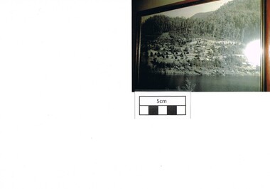
Photograph Bogong, Bogong Township Circa 1950, circa 1940s to 1950s
... Kiewa Valley Historical Society Mount Beauty Information Centre 31 Bogong High Plains Rd Mt Beauty high-country The Bogong Village was originally constructed (1937-1940) by the State Electricity Commission to house, engineers and construction workers working on the Kiewa Hydroelectric Scheme. These workers were initially settled in 26 houses and were mainly of European heritage ...The Bogong Village was originally constructed (1937-1940) by the State Electricity Commission to house, engineers and construction workers working on the Kiewa Hydroelectric Scheme. These workers were initially settled in 26 houses and were mainly of European heritage. At the completion of the scheme, in the 1960's, the village was opened to public/tourism use. This photograph shows the village before beautification for tourism was introduced and "bare bones" homes and village usage existed.This photo clearly presents a period of restricted human occupation of a very fragile Alpine environment(up to 4000 workmen involved). This was the beginning of a planned and controlled form of sustainable tourist orientated development of the Victorian Alps and high plains region. The Bogong Township was the base camp for workers employed by the State Electricity Commission. After the construction phase was completed, the planning and controls originating from this period have been modified to allow a greater public access of this unique environment.Photograph of a framed glass enclosed black and white photograph of the Bogong settlement Paper details "KodakXtraLife paper" on back of photo. bogong village, bogong township, sec alpine constructions, hydro, kiewa scheme -
 Kiewa Valley Historical Society
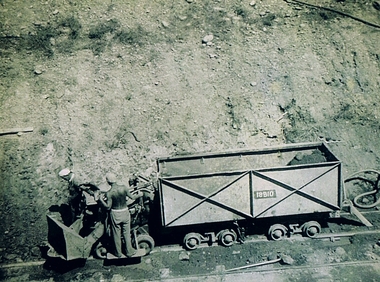
Photograph Shovel Truck, Shovel Loading Rail Truck, circa 1950s
... Kiewa Valley Historical Society Mount Beauty Information Centre 31 Bogong High Plains Rd Mt Beauty high-country This item shows the excavation of the side of a railway track using a pneumatic shovel and a rail mounted truck by two workmen. The period covered was well before State Health and Safety requirements, such as helmets, became law. It also details that the workmen were from European heritage ...This item shows the excavation of the side of a railway track using a pneumatic shovel and a rail mounted truck by two workmen. The period covered was well before State Health and Safety requirements, such as helmets, became law. It also details that the workmen were from European heritage as their head coverings were a handkerchief knotted at each corner. This was typical for workmen of this heritage, others used caps or hats or no head covering at all (the macho male look)The photograph of this item was one of many depicting great achievements and opening up the region. A visual link or time capsule of the 1950s rural/mining sectors clashing with the established rural industriesThis photo depicts the time (1950's) and place (Bogong and Mount Beauty) where construction workers had an immense impact, not only on the physical environment but also on the social and economic development of the Victorian Alps region. The fast expansion of smaller settlements brought about increased pressures on the welfare viability of certain subgroups within the region e.g. farming, droving and commerce (caravan hawkers versus static shops). These changes brought about a heightened awareness by both local and State Governments to upgrade not only facilities within the region but also access to the region. Black and white photo of two workmen on a rail mounted shovel truck. The photo is of good definition allowing a clear view of the subject matter. The paper is semi gloss.On the back of the photo, paper suppliers etchings are "Kodak XtraLife II paper"mining, hydro electricity, victorian alps, construction camps, earth moving machines -
 Emerald Museum & Nobelius Heritage Park
Postcard - Warragal District Postcards, c. 1900s
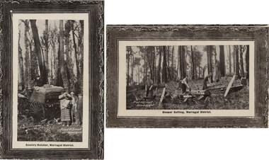
... Heritage Park 5 Crichton Rd Emerald yarra-valley-and-the-dandenong-ranges This postcard is part of an album of postcards which date from late 19th century to mid 20th century. Now spelt as 'Warragul', these postcards use the word "Warragal", which is one spelling for the word for 'dingo' in the Darug language. This postcard is in an album of postcards dating from the late 19th century to mid 20th century and, as such, indicate the popularity of postcards during that time. Postcard 1900s "Green Postcard Album" VEMU2231.1: 'Country ...This postcard is part of an album of postcards which date from late 19th century to mid 20th century. Now spelt as 'Warragul', these postcards use the word "Warragal", which is one spelling for the word for 'dingo' in the Darug language.This postcard is in an album of postcards dating from the late 19th century to mid 20th century and, as such, indicate the popularity of postcards during that time.Two postcards depicting various types of work in the Warragal District, produced by newsagent Fred H Small.VEMU2231.1: 'Country Butcher, Warragal District' VEMU2231.2: 'Sleeper Cutting, Warragal District'postcard, 1900s, "green postcard album" -
 Emerald Museum & Nobelius Heritage Park
Administrative record - Account Book, 1893 - 1902
... Heritage Park 5 Crichton Rd Emerald yarra-valley-and-the-dandenong-ranges This account book is a record of accounts of the Gembrook Nurseries (aka Nobelius Nurseries) in their early days. This account book is a record of the early days of the Gembrook Nurseries which were considered, at their height in 1914, to be the largest in the Southern Hemisphere and which had a significant influence on parks, gardens and streetscapes throughout Australia and in other countries. ...This account book is a record of accounts of the Gembrook Nurseries (aka Nobelius Nurseries) in their early days.This account book is a record of the early days of the Gembrook Nurseries which were considered, at their height in 1914, to be the largest in the Southern Hemisphere and which had a significant influence on parks, gardens and streetscapes throughout Australia and in other countries.Grey embossed leather hard-cover account book with partial leather binding, brown marbled end pages, A-Z tabbed pages with list of accounts followed by 530 pages. Dates start 12 November 1893 and conclude 15 June1902.gembrook nurseries, nobelius nurseries, carl axel nobelius, account book, 1890s -
 Emerald Museum & Nobelius Heritage Park
Administrative record - Account Book, 1902 - 1922
... Heritage Park 5 Crichton Rd Emerald yarra-valley-and-the-dandenong-ranges This account book is a record of accounts of the Gembrook Nurseries (aka Nobelius Nurseries) in their early days. This account book provides an insight into the operations (including client details) of the Gembrook Nurseries which were considered, at their height in 1914, to be the largest in the Southern Hemisphere and which had a significant influence on parks, gardens and streetscapes throughout Australia and in other countries. ...This account book is a record of accounts of the Gembrook Nurseries (aka Nobelius Nurseries) in their early days.This account book provides an insight into the operations (including client details) of the Gembrook Nurseries which were considered, at their height in 1914, to be the largest in the Southern Hemisphere and which had a significant influence on parks, gardens and streetscapes throughout Australia and in other countries. Accounts Book of the Gembrook Nurseries (aka Nobelius Nurseries). Hard cover with brown leather binding. A-Z tabbed pages at start of book shows account holders and is followed by account records which start 9 December 1902 and conclude 6 June 1922. 1002 pages but not all are used.On spine in gold letters with red background "LEDGER"gembrook nurseries, nobelius nurseries, carl axel nobelius, account book, 1900s -
Emerald Museum & Nobelius Heritage Park
Administrative record - Account Books
... Heritage Park 5 Crichton Rd Emerald yarra-valley-and-the-dandenong-ranges These account books provide an insight into the early operations of the Gembrook Nurseries including the range of their clients. These books are significant because they are among the earliest records of the Gembrook Nurseries. The Nurseries, at their height in 1914, were considered to be the largest in the Southern Hemisphere and influenced the development of parks, streetscapes, private and public gardens throughout Australia. They also exported trees to several other countries ...These account books provide an insight into the early operations of the Gembrook Nurseries including the range of their clients.These books are significant because they are among the earliest records of the Gembrook Nurseries. The Nurseries, at their height in 1914, were considered to be the largest in the Southern Hemisphere and influenced the development of parks, streetscapes, private and public gardens throughout Australia. They also exported trees to several other countries.Two consecutively dated Account Books compiled by the Gembrook Nurseries (aka Nobelius Nurseries). Both are hard-cover volumes which are divided into two parts: account holders who are listed on A-Z tabbed pages followed by account records. One volume was used from 12 November 1893 to 15 June 1902. The second volume was used from 9 December 1902 to 6 June 1922.carl axel nobelius, gembrook nurseries, c. a. nobelius & sons, account books, 1890s, 1900s -
 Emerald Museum & Nobelius Heritage Park
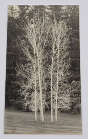
Photograph - Image of 5 silver birch trees at the Emerald Country Club, Rocky Koopmans, The Five Sisters, 1971-1973
... Emerald Museum & Nobelius Heritage Park 5 Crichton Rd Emerald yarra-valley-and-the-dandenong-ranges Photograph taken by Rocky Koopmans in 1971/73 of 5 silver birch trees at the Emerald Country Club. ...Photograph taken by Rocky Koopmans in 1971/73 of 5 silver birch trees at the Emerald Country Club. Trees known as the five sistersBlack & White photograph of 5 silver birch trees 'The Five Sisters' at the Emerald Country Club 'The Five Sisters birches at Emerald Coiuntry Club, Photo by Rocky Koopmans, Taken 1971/73photograph, emerald country club -
 Emerald Museum & Nobelius Heritage Park
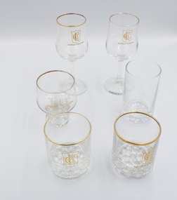
Functional object - Drinking glasses, 1983-1995
... Emerald Museum & Nobelius Heritage Park 5 Crichton Rd Emerald yarra-valley-and-the-dandenong-ranges The Emerald Country Club operated from the late 1920s until around 2010 on the northern section of the land previously occupied by Gembrook Nurseries. ...The Emerald Country Club operated from the late 1920s until around 2010 on the northern section of the land previously occupied by Gembrook Nurseries. The building was modelled on American country clubs of the time. The Club's profile included a golf club and a bowls club serviced by a club house that provided meeting and eating facilities. It played an important role in the local community as it attracted state, national and international visitors for special sporting events and regular recreation. These glasses were bowls trophies presented to Doreen Ball for success in singles or team events between 1983 and 1995The six glasses are artefacts from the Emerald Country Club which was an iconic part of the Emerald community for around 90 years. It contributed to and played a major role in the social and sporting profile of the district.Six decorative clear drinking glasses awarded as prizes by the Emerald Country Club. "Emerald Country Club" with associated logoemerald, emerald country club, emerald country club and golf course, sports, trophy, glassware -
 Emerald Museum & Nobelius Heritage Park
Functional object - Wine glasses, 1983-1995
... Emerald Museum & Nobelius Heritage Park 5 Crichton Rd Emerald yarra-valley-and-the-dandenong-ranges The Emerald Country Club operated from the late 1920s until around 2010 on the northern section of the land previously occupied by Gembrook Nurseries. ...The Emerald Country Club operated from the late 1920s until around 2010 on the northern section of the land previously occupied by Gembrook Nurseries. Its profile included a golf club and a bowls club serviced by a club house that provided meeting and eating facilities. It played an important role in the local community as it attracted state, national and international visitors for special sporting events and regular recreation. These wine glasses were awarded as prizes to Doreen Ball for successes in singles or teams bowls events between 1983-1995.The six glasses are artefacts from the Emerald Country Club which was an iconic part of the Emerald community for around 90 years. It contributed to and played a major role in the social and sporting profile of the district.Two wine glasses awarded as prizes by the Emerald Country Club. On bowl: 'ECC' / BOWLS TROPHY' Under base: ' FRANCE LUMINARE'emerald, emerald country club, emerald country club and golf course, sports, trophy, glassware, bowls -
 Emerald Museum & Nobelius Heritage Park
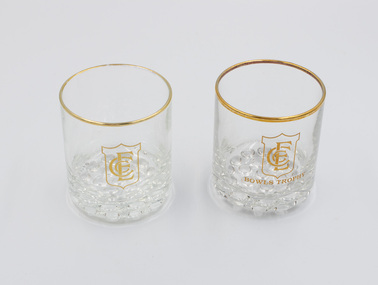
Functional object - Two drinking glasses, 1980s-1990s
... Emerald Museum & Nobelius Heritage Park 5 Crichton Rd Emerald yarra-valley-and-the-dandenong-ranges The Emerald Country Club operated from the late 1920s until around 2010 on the northern section of the land previously occupied by Gembrook Nurseries. ...The Emerald Country Club operated from the late 1920s until around 2010 on the northern section of the land previously occupied by Gembrook Nurseries. Its profile included a golf club and a bowls club serviced by a club house that provided meeting and eating facilities. It played an important role in the local community as it attracted state, national and international visitors for special sporting events and regular recreation. These glasses were awarded as prizes to Doreen Ball for successes in bowls singles or team events between 1983-1995.These glasses are artefacts from the Emerald Country Club which was an iconic part of the Emerald community for around 90 years. It contributed to and played a major role in the social and sporting profile of the district.Two short, squat trophy glasses with 'bubble' base and gold rim. On bowl: 'ECC / BOWLS TROPHY'emerald, emerald country club, emerald country club and golf course, sports, trophy, glassware, bowls -
 Emerald Museum & Nobelius Heritage Park
Functional object - Drinking glass
... Emerald Museum & Nobelius Heritage Park 5 Crichton Rd Emerald yarra-valley-and-the-dandenong-ranges The Emerald Country Club operated from the late 1920s until around 2010 on the northern section of the land previously occupied by Gembrook Nurseries. ...The Emerald Country Club operated from the late 1920s until around 2010 on the northern section of the land previously occupied by Gembrook Nurseries. Its profile included a golf club and a bowls club serviced by a club house that provided meeting and eating facilities. It played an important role in the local community as it attracted state, national and international visitors for special sporting events and regular recreation. This glass is part of a group of six glasses - the other five are clearly marked as trophy glasses but not this one.This glass is an artefact from the Emerald Country Club which was an iconic part of the Emerald community for around 90 years. It contributed to and played a major role in the social and sporting profile of the district.One tall, plain drinking glass with 'bubble' base and Emerald Country Club logo on the side. "Emerald Country Club" with associated logoemerald, emerald country club, emerald country club and golf course, sports, trophy, glassware -
 Emerald Museum & Nobelius Heritage Park
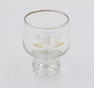
Functional object - Drinking glass with short stem, c.1980s-1990s
... Emerald Museum & Nobelius Heritage Park 5 Crichton Rd Emerald yarra-valley-and-the-dandenong-ranges The Emerald Country Club operated from the late 1920s until around 2010 on the northern section of the land previously occupied by Gembrook Nurseries. ...The Emerald Country Club operated from the late 1920s until around 2010 on the northern section of the land previously occupied by Gembrook Nurseries. Its profile included a golf club and a bowls club serviced by a club house that provided meeting and eating facilities. It played an important role in the local community as it attracted state, national and international visitors for special sporting events and regular recreation. This was awarded to Doreen Ball for success in a bowls competition between 1983 and 1995.This glass is an artifact from the Emerald Country Club which was an iconic part of the Emerald community for around 90 years. It contributed to and played a major role in the social and sporting profile of the district.One clear drinking glass, squat, round shape, gold-rimmed with a short stem, awarded as a prize by the Emerald Country Club. "BOWLS TROPHY" with associated ECC logo on the bowlemerald, emerald country club, emerald country club and golf course, sports, trophy, glassware -
 Emerald Museum & Nobelius Heritage Park
Sepia photograph, Nightingale/Thompson Collection, c 1870 to 1915
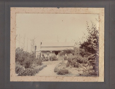
... Heritage Park 5 Crichton Rd Emerald yarra-valley-and-the-dandenong-ranges Photograph of farmhouse with family members on front veranda. Inscription on the back reads: 'To dear Emma with love from Lizzy'. Emma is possibly Emma Augusta Nightingale (nee Thompson) b 1859; d 1949. Lizzie is possibly Elizabeth Anna Thompson (nee Fleming) b 1874; d 1954 information sourced from Nightingale Family History folder Clear photograph depicting country ...Photograph of farmhouse with family members on front veranda. Inscription on the back reads: 'To dear Emma with love from Lizzy'. Emma is possibly Emma Augusta Nightingale (nee Thompson) b 1859; d 1949. Lizzie is possibly Elizabeth Anna Thompson (nee Fleming) b 1874; d 1954 information sourced from Nightingale Family History folder Clear photograph depicting country farmhouse with large family on front veranda, very good example of charming country cottage garden with plants easily recognisable Sepia photograph mounted on brown card'To dear Emma with love from Lizzy'thompson collection, nightingale -
 Emerald Museum & Nobelius Heritage Park
Golf Trophy
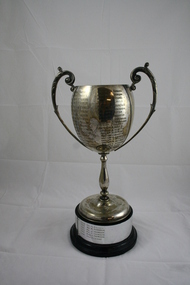
... Emerald Museum & Nobelius Heritage Park 5 Crichton Rd Emerald yarra-valley-and-the-dandenong-ranges Emerald Country Club Associates Ladies Championship Trophy from 1937 to 1996 Local golf club trophy donated by ex committee member Rosalie Leake Emerald Country Club WM Kennon Cup Golf Trophy 1937 to 1996 Emerald Country Club Associates E.M..KENNON CUP 1937 Mrs G.L. ...Emerald Country Club Associates Ladies Championship Trophy from 1937 to 1996Local golf club trophy donated by ex committee member Rosalie LeakeSilver Golf Trophy Cup (Ladies) on wooden base.. engraved with winners from 1937 to 1996 Emerald Country Club Associates E.M..KENNON CUP 1937 Mrs G.L. Elkins 1938 Mrs T.W. Gunnersen 1939 Mrs Norman 1940 Mrs A. Baker 1946 Mrs L.A. Fenton 1947 Mrs A.L. Newold 1948 Mrs C. Bedgood 1949 Mrs A. Baker 1950 Miss P. Massey 1951 Mrs W.H. Symon 1952 Mrs W.H. Symon 1953 Mrs A.L. Newbold 1954 Mrs W.H. Symon 1955 Miss M. Jamison 1956 Mrs W.H. Symon 1957 Miss J. Mellor 1958 Mrs L. Bulmer 1959 Mrs W.H. Symon 1960 Miss J. Mellor 1961 Mrs E. Hoy 1962 Mrs L. Bulmer 1963 Miss D. Smith 1964 Mrs N. Tuxen 1965 Mrs M. Hanger 1966 Mrs A. Howard 1967 Mrs R. Morgan 1968 Mrs P. Young 1969 Mrs J. Little 1970 Mrs J. Fountain 1971 Miss P. Jackson 1972 Mrs J. Little 1973 Mrs J. Houghton 1974 Mrs J. Meldrum 1975 Mrs. B. Barraclough 1976 Mrs J. Meldrum 1977 Mrs F. Gooch 1978 Mrs S. Hunter 1979 Ms F. Fenton 1980 Mrs J. Martin 1981 Mrs C. Grand-Court 1982 Mrs J. Pugh 1983 Mrs M. Ruigrok 1984 Mrs P. Summers 1985 Miss A. Scurry 1986 Mrs P. White 1987 Mrs M. Ruigrok 1988 Mrs P. White 1989 J. Ross 1990 Miss B. Bates 1991 Ms A. Felgate 1992 Ms M. Purbrick 1993 Ms J. Thomson 1994 Ms J Tomson 1995 Ms J Thomson 1996 Mrs R. Leake emerald country club, wm kennon cup, golf trophy 1937 to 1996 -
 Emerald Museum & Nobelius Heritage Park
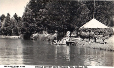
Postcard, Emerald Country Club Swimming Pool, Emerald, Vic, circa 1930's - 50's
... Emerald Museum & Nobelius Heritage Park 5 Crichton Rd Emerald yarra-valley-and-the-dandenong-ranges Emerald Country Club and Golf Course was originally part of the Nobelius Nursery complex. ...Emerald Country Club and Golf Course was originally part of the Nobelius Nursery complex. When Nobelius died in 1921 the nursery was sold, and part of the grounds developed as the Emerald Country Club (20's) the Emerald Country Club and Golf Course still exists and functions as originally intendedHistory of Emerald Country Club and Golf CourseB/W postcard showing a party of people swimming in pool. Rose Series Postcard P.2469Front: The Rose Series P.2469 'Emerald Country Club Swimming Pool, Emerald, Vic. Back: Published by the Rose Stereograph Co. Armadale, Vic. The "Rose" Series De Luxe A Real Photograph Produced in Australiaemerald country club and golf course, rose series -
 Emerald Museum & Nobelius Heritage Park
B/W Photograph, December 1904
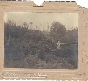
... Emerald Museum & Nobelius Heritage Park 5 Crichton Rd Emerald yarra-valley-and-the-dandenong-ranges The card was probably sent as a Christmas gift to an unknown recipient by "H & GB", presumably a married couple. The two women in the photo might be known to sender and receiver, or might even be the receivers. The scene is suspected to be in the grounds of the Country ...The card was probably sent as a Christmas gift to an unknown recipient by "H & GB", presumably a married couple. The two women in the photo might be known to sender and receiver, or might even be the receivers. The scene is suspected to be in the grounds of the Country Club at Emerald, Victoria.As the card is clearly dated, and the figures clearly named, it is a record of people resident in Emerald. From it we can make out some details of their dress and the physical surroundings of the time.B/W photograph mounted on embossed cardboard with crimped edges. It depicts two women standing on a small bridge over a creek in dense vegetation. There are trees in the background and ferns in the foreground. Front bottom left: silver embossed "With the Compliments of the Season" Rear: Handwritten "Mrs Airey & Miss Doolan on Bridge over Creek From ?H & ?GB 18?/12/1904" At bottom: "May be Country Club"airey, doolan, creek, country club, 1904