Showing 27 items matching "aerial photograph - kew"
-
 Kew Historical Society Inc
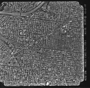
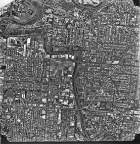
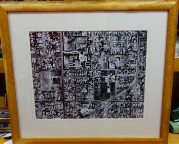
Photograph - Aerial photograph: City of Kew No.1/6, Department of Property & Services (Victoria), 12/12/1987
... Aerial photograph: City of Kew No.1/6......aerial photograph -- kew (vic.)...One of a series of six small square black and white aerial photographs of Kew taken and produced by the Victorian Department of Property Services....Aerial photograph of a part of Kew, taken by photographers employed by the Victorian Department of Property and Services in December 1987....Photograph Aerial photograph: City of Kew No.1/6 Department of Property & Services (Victoria) ...One of a series of six small square black and white aerial photographs of Kew taken and produced by the Victorian Department of Property Services.Aerial photographs, of which the Society has a number in its collection, allow researchers to identify changes in urban infrastructure and demographics over timeAerial photograph of a part of Kew, taken by photographers employed by the Victorian Department of Property and Services in December 1987.4132-106 Ringwood M'Sheet 7922-3 Run 4 5600'ASL Vic DPS © 12-12-87aerial photography, aerial photograph -- kew (vic.) -
 Kew Historical Society Inc
Photograph, Department of Property & Services (Victoria), City of Kew No.2/6, 12/12/1987
... aerial photograph - kew...One of a series of six small square black and white aerial photographs of Kew taken and produced by the Victorian Department of Property Services....Aerial photograph of a part of Kew, taken by photographers employed by the Victorian Department of Property and Services in December 1987....Kew Historical Society Inc Kew Court House 188 High Street Kew melbourne One of a series of six small square black and white aerial photographs of Kew taken and produced by the Victorian Department of Property Services. ...One of a series of six small square black and white aerial photographs of Kew taken and produced by the Victorian Department of Property Services.Aerial photographs, of which the Society has a number in its collection, allow researchers to identify changes in urban infrastructure and demographics over timeAerial photograph of a part of Kew, taken by photographers employed by the Victorian Department of Property and Services in December 1987.aerial photograph - kew -
 Kew Historical Society Inc
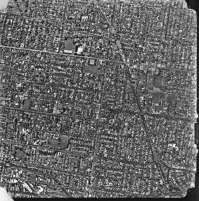
Photograph, Department of Property & Services (Victoria), City of Kew No.3/6, 12/12/1987
... aerial photograph - kew...One of a series of six small square black and white aerial photographs of Kew taken and produced by the Victorian Department of Property Services....Aerial photograph of a part of Kew, taken by photographers employed by the Victorian Department of Property and Services in December 1987....Aerial photographs, of which the Society has a number in its collection, allow researchers to identify changes in urban infrastructure and demographics over time aerial photograph - kew aerial photographs Aerial photograph of a part of Kew, taken by photographers employed by the Victorian Department of Property and Services in December 1987. ...One of a series of six small square black and white aerial photographs of Kew taken and produced by the Victorian Department of Property Services.Aerial photographs, of which the Society has a number in its collection, allow researchers to identify changes in urban infrastructure and demographics over timeAerial photograph of a part of Kew, taken by photographers employed by the Victorian Department of Property and Services in December 1987.aerial photograph - kew, aerial photographs -
 Kew Historical Society Inc
Photograph, Department of Property & Services (Victoria), City of Kew No.4/6, 12/12/1987
... aerial photograph - kew...One of a series of six small square black and white aerial photographs of Kew taken and produced by the Victorian Department of Property Services....Aerial photograph of a part of Kew, taken by photographers employed by the Victorian Department of Property and Services in December 1987....Aerial photographs, of which the Society has a number in its collection, allow researchers to identify changes in urban infrastructure and demographics over time aerial photograph - kew aerial photographs Aerial photograph of a part of Kew, taken by photographers employed by the Victorian Department of Property and Services in December 1987. ...One of a series of six small square black and white aerial photographs of Kew taken and produced by the Victorian Department of Property Services.Aerial photographs, of which the Society has a number in its collection, allow researchers to identify changes in urban infrastructure and demographics over timeAerial photograph of a part of Kew, taken by photographers employed by the Victorian Department of Property and Services in December 1987.aerial photograph - kew, aerial photographs -
 Kew Historical Society Inc
Photograph, Department of Property & Services (Victoria), City of Kew, No.5/6, 12/12/1987
... aerial photograph - kew...One of a series of six small square black and white aerial photographs of Kew taken and produced by the Victorian Department of Property Services....Aerial photograph of a part of Kew, taken by photographers employed by the Victorian Department of Property and Services in December 1987....Aerial photographs, of which the Society has a number in its collection, allow researchers to identify changes in urban infrastructure and demographics over time aerial photograph - kew aerial photographs Aerial photograph of a part of Kew, taken by photographers employed by the Victorian Department of Property and Services in December 1987. ...One of a series of six small square black and white aerial photographs of Kew taken and produced by the Victorian Department of Property Services.Aerial photographs, of which the Society has a number in its collection, allow researchers to identify changes in urban infrastructure and demographics over timeAerial photograph of a part of Kew, taken by photographers employed by the Victorian Department of Property and Services in December 1987.aerial photograph - kew, aerial photographs -
 Kew Historical Society Inc
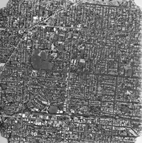
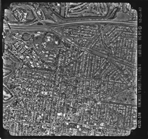
Photograph, Department of Property & Services (Victoria), City of Kew, No.6/6, 12/12/1987
... aerial photograph - kew...One of a series of six small square black and white aerial photographs of Kew taken and produced by the Victorian Department of Property Services....Aerial photograph of a part of Kew, taken by photographers employed by the Victorian Department of Property and Services in December 1987....Kew Historical Society Inc Kew Court House 188 High Street Kew melbourne One of a series of six small square black and white aerial photographs of Kew taken and produced by the Victorian Department of Property Services. ...One of a series of six small square black and white aerial photographs of Kew taken and produced by the Victorian Department of Property Services.Aerial photographs, of which the Society has a number in its collection, allow researchers to identify changes in urban infrastructure and demographics over timeAerial photograph of a part of Kew, taken by photographers employed by the Victorian Department of Property and Services in December 1987.4312-108 Ringwood M'Sheet 7922-3 Run 4 5600'ASL Vic DPS © 12-12-87aerial photograph - kew, aerial photographs -
 Kew Historical Society Inc
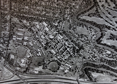
Photograph - Framed Photograph, Aerial Photograph, Willsmere Hospital (Kew), 1988, 1988
... Aerial Photograph, Willsmere Hospital (Kew), 1988...Kew melbourne Dr Frederick Stamp graduated from Bristol Medical School (UK) in 1968. He and his family emigrated to Australia in 1977 to Goulburn (NSW), moving to Melbourne in 1980. He became Superintendent at Willsmere in 1991 until its closure in 1988. Important photograph of the Kew Mental Hospital in the year of its closure. aerial ...Dr Frederick Stamp graduated from Bristol Medical School (UK) in 1968. He and his family emigrated to Australia in 1977 to Goulburn (NSW), moving to Melbourne in 1980. He became Superintendent at Willsmere in 1991 until its closure in 1988.Important photograph of the Kew Mental Hospital in the year of its closure.Framed, colour aerial photograph of the Willsmere Hospital, presented to Dr Fred Stamp (1941-2018), the Medical Superintendent of the Hospital from 1981 until its closure in 1988.aerial photographs - kew (vic), dr fred stamp, willsmere -
 Kew Historical Society Inc
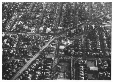
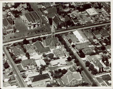
Photograph - Kew Junction, Herald & Weekly Times, 1962
... ...aerial photograph (kew)...An aerial photograph of Kew Junction, showing the intersection of High Street South, Studley Park Road, Princess Street, High Street and Denmark Street. ...Chinner". An aerial photograph of Kew Junction, showing the intersection of High Street South, Studley Park Road, Princess Street, High Street and Denmark Street. ...This is an aerial oblique image looking north. It shows Kew Junction before construction of VicRoads (Country Roads Board), Murphy's (Leo's) supermarket, and office towers. It also shows a building on the land now known as the Raoul Wallenberg Reserve, the Kew Municipal Offices in Walpole Street, and St Paul's School for the Blind in Fernhurst Grove, and Kew Bowling Club in Wellington Street.An aerial photograph of Kew Junction, showing the intersection of High Street South, Studley Park Road, Princess Street, High Street and Denmark Street. A number of buildings, now demolished can be identified in the photo, including Jellis’ Bakeries on the corner of Princess Street and Studley Park Road." Annotation on reverse: "Kew Historical Society from Mr L. H. Chinner".kew junction, aerial photograph (kew), oblique aerial, st paul's school for the blind, kew municipal offices, high street kew, studley park road, kew war memorial, kew post office, kew police station, kew court house, high street south, kew, wellington street kew, denmark street kew -
 Kew Historical Society Inc
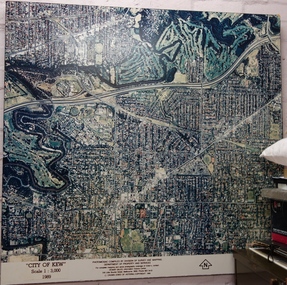
Photograph - Aerial Photograph, Division of Survey and Mapping, Department of Property and Services, City of Kew, Scale 1 : 3,000, 1989, 1989
... Very large aerial photograph of “City of Kew” Scale 1 : 3,000. 1989. ...kew (Vic.) aerial photography “City of Kew” Scale 1 : 3,000. 1989. Photomosaic compiled by Division of Survey and Mapping, Department of Property and Services. © Crown (State of Victoria) Copyright 1990. Very large aerial photograph ...The City of Kew was a local government area about 4 kilometres east of Melbourne, the state capital of Victoria, Australia, on the southeast bank of the Yarra River. The city covered an area of 14.56 square kilometres, and existed from 1860 until 1994.Very large aerial photograph of “City of Kew” Scale 1 : 3,000. 1989. “City of Kew” Scale 1 : 3,000. 1989. Photomosaic compiled by Division of Survey and Mapping, Department of Property and Services. © Crown (State of Victoria) Copyright 1990.city of kew, kew (vic.), aerial photography -
 Kew Historical Society Inc
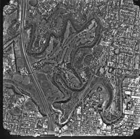
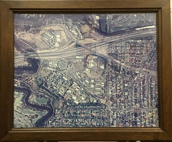
Photograph - Aerial Photograph, Aerial Photograph of Willsmere, circa 1980, c. 1980
... This aerial photograph shows the Kew Cottages, and doctors/clergy residences on the north side of Wills Street, before the State Government sold the land for residential development. ...Aerial photograph of Willsmere and the Kew Cottages bounded by the Boulevard, the Chandler Highway, Princess Street and Fellows Street. ...According to neighbours of the time most of the buildings were demolished overnight in the 1980s. kew cottages eastern freeway willsmere yarra river aerial photographs -- kew (vic) kew boulevard Willsmere Mental Hospital kew mental hospital Kew Childrens Cottages Aerial photograph of Willsmere and the Kew Cottages bounded by the Boulevard, the Chandler Highway, Princess Street and Fellows Street. ...This aerial photograph shows the Kew Cottages, and doctors/clergy residences on the north side of Wills Street, before the State Government sold the land for residential development. The doctors residences in Wills street were made of 'Glen Iris' Olympic Bricks. According to neighbours of the time most of the buildings were demolished overnight in the 1980s.Aerial photograph of Willsmere and the Kew Cottages bounded by the Boulevard, the Chandler Highway, Princess Street and Fellows Street. The roundabout at the intersection of Princess Street, Wills Street, and Eglinton Street is at the top left. The Eastern Freeway is at the lower edge of the photograph.kew cottages, eastern freeway, willsmere, yarra river, aerial photographs -- kew (vic), kew boulevard, willsmere mental hospital, kew mental hospital, kew childrens cottages -
 Ringwood and District Historical Society
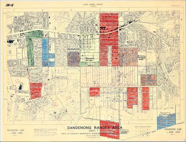
Map - State Aerial Survey, Dandenong Ranges Area Sheet 7, Parishes of Warrandyte, Scoresby, Ringwood and Nunawading - 1956
... aerial photographs and Cadastral Survey information. Subsequent coloured hand-drawn additions showing layout of a number of post-NSW Separation era proposed subdivisions that did not eventuate, including Village of Studley Estate, Township of East Kew Estate, Township of Ballyduffy Estate, Township of New Flemington Estate, Township of East Hawthorne Estate. ...aerial photographs and Cadastral Survey information. Subsequent coloured hand-drawn additions showing layout of a number of post-NSW Separation era proposed subdivisions that did not eventuate, including Village of Studley Estate, Township of East Kew Estate, Township of Ballyduffy Estate, Township of New Flemington Estate, Township of East Hawthorne Estate. ...Map of central and southern areas of Ringwood and part of Ringwood East and Heathmont compiled by Dept of Lands and Survey, July 1956, from aerial photographs and Cadastral Survey information. Subsequent coloured hand-drawn additions showing layout of a number of post-NSW Separation era proposed subdivisions that did not eventuate, including Village of Studley Estate, Township of East Kew Estate, Township of Ballyduffy Estate, Township of New Flemington Estate, Township of East Hawthorne Estate. Ringwood A4B2, 849 A4B Zone 7. Scale: 10 chains to 1 inch. Contour interval 20 feet. -
 Villa Alba Museum
Document, Villa Alba Museum Archaeological Test Excavations, 2002
... Kew melbourne Conservation studies Conservation reports archaeological reports villa alba museum A preliminary report on archaeological test excavations, conducted on 5 & 7 September 2002 by Maddy Atkinson (Ripple Arc). The purpose of the excavations was twofold. Firstly, to conduct subsurface testing at Villa Alba to determine the presence, location and depth below ground of archaeological remains relating to a number of landscape features identified in historical plans, photographs, survey field books and aerial photographs. ...A preliminary report on archaeological test excavations, conducted on 5 & 7 September 2002 by Maddy Atkinson (Ripple Arc). The purpose of the excavations was twofold. Firstly, to conduct subsurface testing at Villa Alba to determine the presence, location and depth below ground of archaeological remains relating to a number of landscape features identified in historical plans, photographs, survey field books and aerial photographs. Secondly, soils surrounding the Villa Alba mansion, which have been found to be contaminated with lead will need to be removed up to a depth of up to 0.6 metres. Removal of deposits from the site may have an adverse impact on any archaeological remains existing below the surface.Contents: Acknowledgements / Abbreviations / List of figures / List of tables / List of plates / Introduction / Historical context / Methodology / Results and interpretations / Discussion / Recommendations / References / Appendix 1 - Plates / Appendix 2 - Content list / Appendix 3 - Copy of Heritage Victoria permit.non-fictionA preliminary report on archaeological test excavations, conducted on 5 & 7 September 2002 by Maddy Atkinson (Ripple Arc). The purpose of the excavations was twofold. Firstly, to conduct subsurface testing at Villa Alba to determine the presence, location and depth below ground of archaeological remains relating to a number of landscape features identified in historical plans, photographs, survey field books and aerial photographs. Secondly, soils surrounding the Villa Alba mansion, which have been found to be contaminated with lead will need to be removed up to a depth of up to 0.6 metres. Removal of deposits from the site may have an adverse impact on any archaeological remains existing below the surface. conservation studies, conservation reports, archaeological reports, villa alba museum -
Villa Alba Museum
Document, Maddy Maitri (Maitri Archaeology), Villa Alba Landscape Reconstruction: Archaeological Test Excavations Phase 2, 2002
... Kew, by Maddy Maitri (Maitri Archaeology) in October 2002. The testing was conducted as part of the design development stage of a proposed landscape reconstruction. The broad aim of subsurface testing at Villa Alba was to determine the presence, location and depth below ground of archaeological remains relating to a number of landscape features identified in historical plans, photographs, survey field books and aerial photographs. ...This document documents the results of archaeological excavations conducted within the grounds of Villa Alba in Kew, by Maddy Maitri (Maitri Archaeology) in October 2002. The testing was conducted as part of the design development stage of a proposed landscape reconstruction. The broad aim of subsurface testing at Villa Alba was to determine the presence, location and depth below ground of archaeological remains relating to a number of landscape features identified in historical plans, photographs, survey field books and aerial photographs. This information would then be used by the landscape architect in the development of a design which approximates the 1880s/1890s landscape of Villa Alba.Contents: Acknowledgements / Abbreviations / List of figures / List of tables / List of plates / Introduction / Historical context / Methodology / Results and interpretations / Discussion / Recommendations / References / Appendix 1 - Plates / Appendix 2 - Content list / Appendix 3 - Copy of Heritage Victoria permit. This document documents the results of archaeological excavations conducted within the grounds of Villa Alba in Kew, by Maddy Maitri (Maitri Archaeology) in October 2002. The testing was conducted as part of the design development stage of a proposed landscape reconstruction. The broad aim of subsurface testing at Villa Alba was to determine the presence, location and depth below ground of archaeological remains relating to a number of landscape features identified in historical plans, photographs, survey field books and aerial photographs. This information would then be used by the landscape architect in the development of a design which approximates the 1880s/1890s landscape of Villa Alba.villa alba - archaeology, villa alba - garden reconstruction, 2002 -
 Kew Historical Society Inc
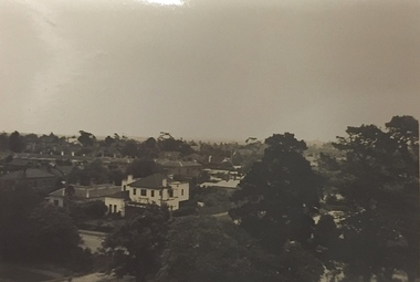
Photograph - Studley Park (Kew), c.1949
... Illapa -- 84 Princess Street -- Kew (Vic.) aerial photographs -- kew (Vic.) studley park (kew) -1930s Small black and white photograph of a panoramic view from the tower of 84 Princess Street, Kew during the occupation of the house by the Weir family during the years 1918-1950. ...An item forming part of a collection of costumes, photographs and documents relating to the Weir family who lived in a mansion, originally named Illapa, at 84 Princess Street, Kew, from c.1917 to 1950. This historically significant collection includes items relating to both George Weir (1866-1937), his wife Edith Mary Weir (1867-1948) and their children. George Weir attained national prominence in the mining industry, becoming General Manager of the North Broken Hill Silver Mining Company in 1903 (later renamed North Broken Hill Mining Company 1905-12, and North Broken Hill Ltd 1912-1988), and subsequently President of the Mine Owners Association. He was to remain General Manager of North Broken Hill Ltd until his retirement in 1926.Small black and white photograph of a panoramic view from the tower of 84 Princess Street, Kew during the occupation of the house by the Weir family during the years 1918-1950. The house and garden had formerly been named Illapa and then Parcnacilla. In 1950 the family sold the house to a religious order who renamed the house 'The Towers'. It now forms part of 'Rylands'.illapa -- 84 princess street -- kew (vic.), aerial photographs -- kew (vic.), studley park (kew) -1930s -
 Kew Historical Society Inc
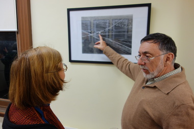
Photograph - Digital Photographs [Series], Robert Baker, Exhibition: Kew From Above, Kew Court House, 2014, 2014
... Smaller displays continue to be mounted in the Kew Library. kew historical society - exhibitions exhibition - aerial photographs - kew (vic) A born digital photograph of members and guests at the exhibition opening. ...The Kew Historical Society, founded in 1958, is one of the oldest continuing historical societies in the Greater Melbourne region. From its beginnings, the Society has mounted exhibitions and/or displays, in early days in shop windows and in community spaces located in the Kew City Hall (later Kew Library), and since 2010 at the Kew Court House. Exhibitions typically coincided with the annual Kew Community Festival in March, but after 2013 evolved into three new exhibitions yearly at the Kew Court House. Smaller displays continue to be mounted in the Kew Library. A born digital photograph of members and guests at the exhibition opening. Photo 1: L-R Terryl de Lacey, Janet Walker, Don Garden Photo 2: Les Littlechild, Sue Littlechild, Ian Job, ..., ... Photo 3: John Torpey, Slavka Jelovac kew historical society - exhibitions, exhibition - aerial photographs - kew (vic) -
 Kew Historical Society Inc
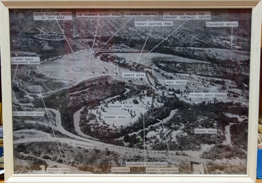
Photograph, Yarra Bend Park Trust, Yarra Bend Park Facilities, 1940s
... Kew Historical Society Inc Kew Court House 188 High Street Kew melbourne Old aerial photograph of Yarra bend Park labelled with park facilities yarra bend park sports facilities - kew - fairfield sir herbert olney oval fairfield hospital chandler bridge deep rock swimming basin kane's footbridge Framed annotated aerial photograph of Yarra Bend Park. ...Old aerial photograph of Yarra bend Park labelled with park facilitiesFramed annotated aerial photograph of Yarra Bend Park. The white frame is original to the work.yarra bend park, sports facilities - kew - fairfield, sir herbert olney oval, fairfield hospital, chandler bridge, deep rock swimming basin, kane's footbridge -
 Kew Historical Society Inc
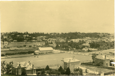
Photograph, J F C Farquhar, Bird's Eye View Looking West, 1891
... photographs are held in national collections. It is believed that the Kew Historical Society’s copy of the Kellett album is unique and that the photographs in the book were the first copies taken from the original plates. It is the first and most important series of images produced about Kew. The individual images have proved essential in identifying buildings and places of heritage value in the district. kew illustrated kew where we live photographic books henry kellett denmark street kew recreation hall kew bowling club wellington street Bird's Eye View Looking West Before true aerial photography became possible, photographers such as J.F.C. ...At the beginning of the 1890s, the Kew businessman and Town Councillor, Henry Kellett, commissioned J.F.C. Farquhar to photograph scenes of Kew. These scenes included panoramas as well as pastoral scenes. The resulting set of twelve photographs was assembled in an album, Kew Where We Live, from which customers could select images for purchase.The preamble to the album describes that the photographs used the ‘argentic bromide’ process, now more commonly known as the gelatine silver process. This form of dry plate photography allowed for the negatives to be kept for weeks before processing, hence its value in landscape photography. The resulting images were considered to be finely grained and everlasting. Evidence of the success of Henry Kellett’s venture can be seen today, in that some of the photographs are held in national collections.It is believed that the Kew Historical Society’s copy of the Kellett album is unique and that the photographs in the book were the first copies taken from the original plates. It is the first and most important series of images produced about Kew. The individual images have proved essential in identifying buildings and places of heritage value in the district.Before true aerial photography became possible, photographers such as J.F.C. Farquhar were compelled to shoot their images from the highest vantage point. Here, it is presumed to be the roof of Xavier College, from which the panoramic view extends west towards the rise of Studley Park. The houses in the foreground face the southern end of Gellibrand Street. Wellington Street is at an angle to the camera with the Queen Street intersection on the near right. The wooden building behind the large horse paddock on the other side of Gellibrand Street is the Kew Recreation Hall, built 1888, demolished 1960. It was reputed to have one of the finest dancing floors in or around Melbourne. The Bowling Green at the rear of the Hall belonged to the Kew Bowling Club. Further west is the Kew Railway Station on Denmark Street, opened to the public in 1887. At this period, much of Studley Park was locked up in large landholdings, dominated by large mansions such as ‘Byram’. Bird's Eye View Looking Westkew illustrated, kew where we live, photographic books, henry kellett, denmark street, kew recreation hall, kew bowling club, wellington street -
 Kew Historical Society Inc
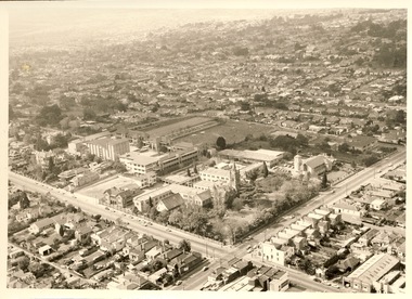
Photograph - Digital Image, Methodist Ladies' College Hawthorn from the Air, 2020
... Kew Historical Society Inc Kew Court House 188 High Street Kew melbourne Digital image of MLC Kew from a photograph album belonging to Judith Scurfield. Methodist Ladies' College - Kew (Vic) aerial photographs Aerial photograph of Methodist Ladies' College, Hawthorn. ...Digital image of MLC Kew from a photograph album belonging to Judith Scurfield.Aerial photograph of Methodist Ladies' College, Hawthorn.methodist ladies' college - kew (vic), aerial photographs -
 Kew Historical Society Inc
Photograph - Aerial View of East Kew, c.1930
... Framed aerial photograph of that part of Kew in which is located Genazzano FCJ, the Kew Reservoir, and the retail nurseries of Bennett’s and Rimington's....Kew was settled from the 1850s with all land sold in the vicinity by 1851. The original large estates were further subdivided in the second half of the 19th and in the first decades of the 20th centuries. Early aerial photograph ...The Municipality of Kew was proclaimed in 1860. This eastern section of Kew was settled from the 1850s with all land sold in the vicinity by 1851. The original large estates were further subdivided in the second half of the 19th and in the first decades of the 20th centuries.Early aerial photograph of KewFramed aerial photograph of that part of Kew in which is located Genazzano FCJ, the Kew Reservoir, and the retail nurseries of Bennett’s and Rimington's.genazzano fcj, kew reservoir, rimington's nurseries, bennett's nursery, cotham road, mont victor road (kew) -
 Kew Historical Society Inc
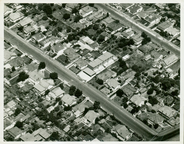
Photograph - Aerial photograph of Cotham Road and Highbury Grove, Kew, c.1970
... Aerial photograph of Cotham Road and Highbury Grove, Kew...Black and white aerial photograph of the intersection of Cotham Road and Highbury Grove in Kew, looking south. ...Kew melbourne This aerial photo was used by John O'Neill in The Church on the Hill, published 1974, so the photo predates that. The photographer is unknown. Cotham. Road -- Kew Highbury Grove -- Kew Mary Street -- Kew St John's Parade -- Kew Alice Anderson Bib Stilwell Kew Baptist Church Kew Presbyterian Church Sacred Heart Church – Kew (Vic.) Sacred Heart Primary School – Kew (Vic.) Nil Black and white aerial photograph ...This aerial photo was used by John O'Neill in The Church on the Hill, published 1974, so the photo predates that. The photographer is unknown.Black and white aerial photograph of the intersection of Cotham Road and Highbury Grove in Kew, looking south. This historically important photo shows major churches and schools in the vicinity, including a number that have since been demolished. Bordering St John''s Parade at the top of the photo are, on the left Sacred Heart Church and Primary School, while on the right are the original buildings of the Kew Baptist Church, beside which is Bib Stilwell's caryard and the remains of Alice Anderson's garage. In the foreground is the new Baptist Church and on Cotham Road, the Kew Presbyterian Church.Nilcotham. road -- kew, highbury grove -- kew, mary street -- kew, st john's parade -- kew, alice anderson, bib stilwell, kew baptist church, kew presbyterian church, sacred heart church – kew (vic.), sacred heart primary school – kew (vic.) -
 Kew Historical Society Inc
Photograph - Aerial photograph of the intersection of Derby and Earl Streets, Kew, c.1970
... Aerial photograph of the intersection of Derby and Earl Streets, Kew...Black and white aerial photograph of the intersection of Derby and Earl Streets in Kew. The photo is presumed to date from c.1970....Derby Street -- Kew (vic.) Nil Black and white aerial photograph of the intersection of Derby and Earl Streets in Kew. ...Black and white aerial photograph of the intersection of Derby and Earl Streets in Kew. The photo is presumed to date from c.1970.Nilearl street -- kew (vic.), derby street -- kew (vic.) -
Kew Historical Society Inc
Photograph, Yarra Bend Park August 1983
... Kew Historical Society Inc Kew Court House 188 High Street Kew melbourne Aerial photographs Yarra Bend Park "Yarra Bend Park" / "Tucana Air Systems" Colour aerial photograph of Yarra Bend Park in 1983 Yarra Bend Park August 1983 Photograph ...Colour aerial photograph of Yarra Bend Park in 1983"Yarra Bend Park" / "Tucana Air Systems"aerial photographs, yarra bend park -
 Ballarat Heritage Services
Photograph - Digital photographs, L.J. Gervasoni, Kew and Hawthorn from the air, c2017
... kew cottages...willsmere...melbourne...aerial...cityscape...landscape...kew...yarra river...aerial photograph...Ballarat Heritage Services PO Box 2209 Bakery Hill Post Office goldfields hawthorn camberwell kew junction eastern freeway camberwell junction glenferrie kew cottages willsmere melbourne aerial cityscape landscape kew yarra river aerial photograph Digital images of the Melbourne suburb od Kew and Hawthorn from the air. ...Digital images of the Melbourne suburb od Kew and Hawthorn from the air.hawthorn, camberwell, kew junction, eastern freeway, camberwell junction, glenferrie, kew cottages, willsmere, melbourne, aerial, cityscape, landscape, kew, yarra river, aerial photograph -
 Ballarat Heritage Services
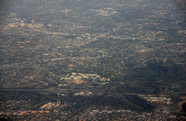
Digital photographs, L.J. Gervasoni, Kew from the Air, c2014
... Colour aerial photograph of the Melbourne Suburb of Kew taken from an aeroplane coming into land at Tullamarine Airport, Melbourne. ...Ballarat Heritage Services PO Box 2209 Bakery Hill Post Office goldfields melbourne kew hawthorn camberwell landscape aerial Colour aerial photograph of the Melbourne Suburb of Kew taken from an aeroplane coming into land at Tullamarine Airport, Melbourne. ...Colour aerial photograph of the Melbourne Suburb of Kew taken from an aeroplane coming into land at Tullamarine Airport, Melbourne. melbourne, kew, hawthorn, camberwell, landscape, aerial -
Kew Historical Society Inc
Plan - Pointed Firs Estate, Camberwell North, 1936
... Kew, a number of other plans and advertisements have been donated by individuals, of which this is an example. Pointed Firs Estate -- Balwyn North Subdivisions -- Balwyn North (Vic.) Original multi-page sales brochure of the Pointed Firs Estate, advertised as located in Camberwell North, but now in Balwyn North. The 4-page bifold brochure includes promotional material as well as a detailed plan of the 28 lots for sale, a photograph of the locality with the plan overlaying it, as well as aerial ...Subdivision plans and real estate flyers/brochures reveal a number of aspects of urban development and history. The Kew Historical Society's collection of these plans, as well as advertisements extracted from magazines, cover key aspects of community development and architectural history of Kew and Kew Eat as well as surrounding suburbs. While most of the plans in the collection were gifted to the Society by the former City of Kew, a number of other plans and advertisements have been donated by individuals, of which this is an example.Original multi-page sales brochure of the Pointed Firs Estate, advertised as located in Camberwell North, but now in Balwyn North. The 4-page bifold brochure includes promotional material as well as a detailed plan of the 28 lots for sale, a photograph of the locality with the plan overlaying it, as well as aerial photos and street views. The estate included lots in Doncaster Road, Thackeray Street, Houghton Street, an dMaud Street. pointed firs estate -- balwyn north, subdivisions -- balwyn north (vic.) -
Kew Historical Society Inc
Booklet - Old Kew Golf Links Estate, 1926
... Kew Council to use the land for industrial development. The estate, advertised was advertised as being within five miles of Melbourne. The brochure is notable as it includes photographs of Kew East Primary School, the former Kew Golf Club clubhouse, and 'The Moorings' Boathouse (aka Chipperfield's Boat House). The aerial...Kew Council to use the land for industrial development. The estate, advertised was advertised as being within five miles of Melbourne. The brochure is notable as it includes photographs of Kew East Primary School, the former Kew Golf Club clubhouse, and 'The Moorings' Boathouse (aka Chipperfield's Boat House). The aerial ...Subdivision plans and real estate flyers/brochures reveal a number of aspects of urban development and history. The Kew Historical Society's collection of these plans, as well as advertisements extracted from magazines, cover key aspects of community development and architectural history of Kew and Kew Eat as well as surrounding suburbs. While most of the plans in the collection were gifted to the Society by the former City of Kew, a number of other plans and advertisements have been donated by individuals, of which this is an example.8-page brochure advertising 80 residential home sites for sale in a subdivision called the 'Old Kew Golf Links Estate'. These sites had historic importance in Kew's history as they had previously belonged to Kodak Pty Ltd who were refused permission by Kew Council to use the land for industrial development. The estate, advertised was advertised as being within five miles of Melbourne. The brochure is notable as it includes photographs of Kew East Primary School, the former Kew Golf Club clubhouse, and 'The Moorings' Boathouse (aka Chipperfield's Boat House). The aerial photograph, overlaid with names of notable sites, on the final page is of interest as it shows the area before the intrusion of the Eastern Freeway, which resulted in changing the course of a section of the Yarra River. old kew golf links estate, subdivision -- kew (vic.), subdivisions -- kew east (vic), chipperfield's boathouse, kew east primary school, kew golf club -
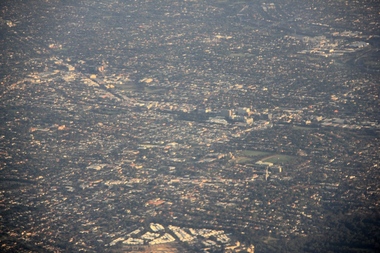
 Melbourne Tram Museum
Photograph - Compact Diskette with photographs, Kevin O'Reilly, "Flyers of Time K'O'Reilly - Tram shots collected", 2012
... aerial photographs of Ballarat (2) and Melbourne ( 15 ) Disc has the hi-resolution TIF files and jpg file. Files in order on CD: Ballarat 5 - copy sent to the Ballarat Tramway Museum - images on this record as tiff files. Ballarat - ditto Elizabeth Street - see htd136 for image Kew...aerial photographs of Ballarat (2) and Melbourne ( 15 ) Disc has the hi-resolution TIF files and jpg file. Files in order on CD: Ballarat 5 - copy sent to the Ballarat Tramway Museum - images on this record as tiff files. Ballarat - ditto Elizabeth Street - see htd136 for image Kew ...CD (Compact Diskette for use in computers) (108mm diameter plastic disc with plastic case and cover) containing a series of aerial photographs of Ballarat (2) and Melbourne ( 15 ) Disc has the hi-resolution TIF files and jpg file. Files in order on CD: Ballarat 5 - copy sent to the Ballarat Tramway Museum - images on this record as tiff files. Ballarat - ditto Elizabeth Street - see htd136 for image Kew Barkers Road - see htd137 for image Kew Burke Road - see htd138 for image Kew Junction - see htd139 for image Merri Creek - see htd140 for image Richmond 6 - see htd141 for set of three images Richmond 7 - see htd142 for image Richmond - see htd141 for set of three images Richmond3- see htd141 for set of three images Royal Park 2 - see htd143 for image Sandringham - see htd144 for image Scotch - see htd145 for image Spencer - see htd146 for image St Kilda 1 - see htd147 for image St Kilda - see htd148 for imagetrams, tramways, melbourne