Showing 90 items matching "air photography"
-
 Bendigo Military Museum
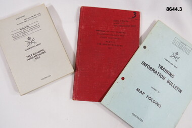
Manual - MAP READING, London War Office, 1958, 1973
... ...Air Photography...Bendigo Military Museum 37 - 39 Pall Mall Bendigo goldfields Passchendaele Barracks Trust Maps Air Photography Field Sketching PBT 69 98 99 1. 3 OCTU 3 TRG GP, Albert Rd, South Melbourne 3205. ...Medium sized manuals to enable officers and NCO's to make use of air photographs when ground reconnaissance is impossible. 1. Manual of map reading, Air Photo Reading and Field Sketching Part II. 2. Training Information Bulletin - map folding. 3. Map Reading AIDE-MEMOIRE 1973 ( x 7 booklets.)1. 3 OCTU 3 TRG GP, Albert Rd, South Melbourne 3205.passchendaele barracks trust, maps, air photography, field sketching, pbt 69 98 99 -
 Bendigo Military Museum
Administrative record - Funds for New Air Photograph coverage of (Australian) Training Areas, DMT, 26 June 1960
... This document is the justification for additional funds to acquire new air photography coverage of Australian Defence Training areas as existing air photography was out of date and the scale of the photography was unsuitable. ...Bendigo Military Museum 37 - 39 Pall Mall Bendigo goldfields This document is the justification for additional funds to acquire new air photography coverage of Australian Defence Training areas as existing air photography was out of date and the scale of the photography was unsuitable. ...This document is the justification for additional funds to acquire new air photography coverage of Australian Defence Training areas as existing air photography was out of date and the scale of the photography was unsuitable. RAAF was incapable of flying the required photography and contractors were required to complete the task. This is the justification for additional funds for the task.2 x poorly photocopied A4 page minute dated 1960royal australian survey corps, rasvy, fortuna, army survey regiment, army svy regt, asr -
 Bendigo Military Museum
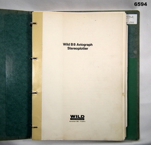
Manual - Wild Heerbrugg B8 Aviograph Stereoplotter Manual 1963, Wild Heerbrugg, Germany, 1963
... Wild Heerbrugg B8 Aviograph Stereoplotters were a very accurate piece of equipment for the extraction of topographical information from stereo air photography. This is an operating manual covering all aspects of the Wild B8 Stereoplotter. ...Bendigo Military Museum 37 - 39 Pall Mall Bendigo goldfields Wild Heerbrugg B8 Aviograph Stereoplotters were a very accurate piece of equipment for the extraction of topographical information from stereo air photography. This is an operating manual covering all aspects of the Wild B8 Stereoplotter. ...Wild Heerbrugg B8 Aviograph Stereoplotters were a very accurate piece of equipment for the extraction of topographical information from stereo air photography. This is an operating manual covering all aspects of the Wild B8 Stereoplotter. Chapters include, construction, descriptions of the optical train, electrical equipment, technical data, assembly (adjustment, instructions for use and maintenance). They were widely used throughout the Royal Australian Survey Corps from 1965 onwards. They were later upgraded with tri axis locators for capturing digital topographical data.Green hard covered operating manual covering all aspects of the Wild B8 Stereoplotter. Chapters include, construction, descriptions of the optical train, electrical equipment, technical data, assembly (adjustment, instructions for use and maintenance). There are 70 x pages of text and plans and diagrams. There are 33 x unnumbered pages of photographs, diagrams and tables. Additional photocopied pages added "P2 Relative Orientation - Semi Numerical Method." "1927" (Presumed to be the Serial Number of the B8 Stereoplotter that the manual was used with).royal australian survey corps, rasvy, fortuna, army survey regiment, army svy regt, asr -
 Bendigo Military Museum
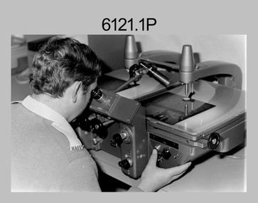
photograph - Aerotriangulation Production – Army Survey Regiment, Fortuna, Bendigo, c1980
... The Zeiss (Jena) Stecometer analytic stereocomparator for air photography was introduced at Air Survey Squadron in 1963. ...The Zeiss (Jena) Stecometer analytic stereocomparator for air photography was introduced at Air Survey Squadron in 1963. ...This collection of five photos was most likely taken in 1980. Wild PUG4 point transfer devices were used by technicians in Air Survey Squadron to stereoscopically view the photography containing the survey control points and the mapping aerial photography. The Control points were transferred from the control photography to the mapping diapositives of aerial photography by drilling their locations into the photographic emulsion. The Zeiss (Jena) Stecometer analytic stereocomparator for air photography was introduced at Air Survey Squadron in 1963. Aerotriangulation production was expedited using computers for analytical photogrammetric processes. The technician accurately measured between pass, tie, and survey control points on aerial photographs.Air Survey Squadron Aerotriangulation Section - Army Survey Regiment, Bendigo. c1980. This is a set of five photographs of Air Survey Squadron personnel operating aerotriangulation equipment at the Army Survey Regiment at Fortuna, Bendigo, c1980. Photographs .1P to .4P are on 35mm negative film and were scanned at 96 dpi. Black and white photo .5P is on photographic paper and was scanned at 300 dpi. They are part of the Army Survey Regiment’s Collection. .1) - Photo, black & white, c1980, Wild PUG4 point transfer device, unidentified technician. .2) - Photo, black & white, c1980, Wild PUG4 point transfer device, unidentified technician. .3) - Photo, black & white, c1980, Wild PUG4 point transfer device, unidentified technician. .4) - Photo, black & white, c1980, Zeiss (Jena) Stecometer, unidentified technician. .5) - Photo, black & white, c1980, Zeiss (Jena) Stecometer..1P to .5P No personnel are identified.royal australian survey corps, rasvy, army survey regiment, army svy regt, fortuna, asr, air survey, aerotrig -
 Bendigo Military Museum
Photograph - Aerotriangulation Production – Army Survey Regiment, Fortuna, Bendigo, c1993
... The Zeiss (Jena) Stecometer analytic stereocomparator for air photography shown in photo .1P was introduced at Air Survey Squadron in 1963. ...The Zeiss (Jena) Stecometer analytic stereocomparator for air photography shown in photo .1P was introduced at Air Survey Squadron in 1963. ...This is a collection of eight photographs of Air Survey Squadron personnel operating aerotriangulation equipment at the Army Survey Regiment at Fortuna, Bendigo, c1993. PUG4 devices were used by technicians to stereoscopically view the photography containing the survey control points and the mapping aerial photography. The Control points were transferred from the control photography to the mapping diapositives of aerial photography by drilling their locations into the photographic emulsion. The Zeiss (Jena) Stecometer analytic stereocomparator for air photography shown in photo .1P was introduced at Air Survey Squadron in 1963. Wild PUG4 point transfer devices shown in photos .2P to .4P were introduced in c1968 superseding the PUG2 devices. See item 6195.19P for more photos and descriptions of Air Survey Squadron personnel and aerotriangulation equipment.This is a set of eight photographs of Air Survey Squadron personnel operating aerotriangulation equipment at the Army Survey Regiment at Fortuna, Bendigo, c1993. The photographs were on 35mm negative film and were scanned at 96 dpi. They are part of the Army Survey Regiment’s Collection. .1) - Photo, black & white, c1993, Zeiss (Jena) Stecometer, SPR Kim Baker. .2) - Photo, black & white, c1993, Wild PUG4 point transfer device, CPL Paul Bouton. .3) to .4) - Photo, black & white, c1993, Wild PUG4 point transfer device, L to R: CPL Darren Scott, CPL Paul Bouton. .5) to .6P) - Photo, black & white, c1993, CPL Doug Willis. .7) - Photo, black & white, c1993, WO2 Noel ‘Macca’ McNamara. .8) - Photo, black & white, c1993, SGT Barry Miller..1P to .8P - There are no annotations.royal australian survey corps, rasvy, army survey regiment, army svy regt, fortuna, asr, aerotrig -
 Bendigo Military Museum
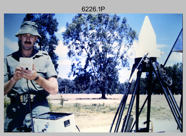
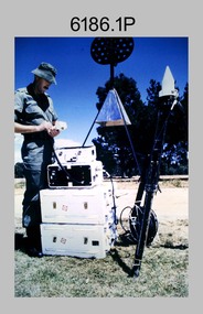
Photograph - Demonstration of TI4100 GPS Receiver, Royal Australian Survey Corps, c1988
... The equipment was deployed to establish the baseline for a GPS controlled air camera and photogrammetric system to significantly reduce the requirement for ground survey to accurately control air photography for topographic mapping. Personnel from the four field survey squadrons at this time were trained at the SMS to operate the TI4100 receivers. ...The equipment was deployed to establish the baseline for a GPS controlled air camera and photogrammetric system to significantly reduce the requirement for ground survey to accurately control air photography for topographic mapping. Personnel from the four field survey squadrons at this time were trained at the SMS to operate the TI4100 receivers. ...This is a set of four photographs of WO2 Graham Ragless from the Royal Australian Survey Corps demonstrating the operation of Global Positioning System equipment in c1988. The photos were probably taken at the School of Military Survey (SMS), Bonegilla, VIC. Texas Instruments TI4100 portable Global Positioning System (GPS) geodetic receivers were introduced from 1986–1988. The GPS receivers and Ferranti FILS3 helicopter and vehicle mounted Inertial Positioning System (IPS) replaced the TRANSIT satellite receivers. The equipment was deployed to establish the baseline for a GPS controlled air camera and photogrammetric system to significantly reduce the requirement for ground survey to accurately control air photography for topographic mapping. Personnel from the four field survey squadrons at this time were trained at the SMS to operate the TI4100 receivers. Field survey operations using GPS and IPS equipment followed in the late 1980s. This technology is described in more detail in the RA Svy booklet titled An Introduction to Topographic Mapping. See record ID - 6010. WO2 Graham Ragless progressed to the rank of WO1 and was appointed as RSM of the Army Survey Regiment from 1990 to 1992. Refer to item 6186.2P for more photographs of WO2 Graham Ragless demonstrating the TI4100.This is a set of four photographs of a technician from the Royal Australian Survey Corps demonstrating the operation of Global Positioning System equipment in c1988. Colour photos are on 35mm slide film and were scanned at 96 dpi. .1) to .4) - Photo, colour, c1988, WO2 Graham Ragless demonstrating the operation of a TI4100 GPS receiverThere are no annotations.royal australian survey corps, rasvy, army survey regiment, army svy regt, fortuna, asr, surveying -
 Bendigo Military Museum
Photograph - Demonstration of TI4100 GPS Receiver, Royal Australian Survey Corps, c1988
... The equipment was deployed to establish the baseline for a GPS controlled air camera and photogrammetric system to significantly reduce the requirement for ground survey to accurately control air photography for topographic mapping. Personnel from the four field survey squadrons at this time were trained at the SMS to operate the TI4100 receivers. ...The equipment was deployed to establish the baseline for a GPS controlled air camera and photogrammetric system to significantly reduce the requirement for ground survey to accurately control air photography for topographic mapping. Personnel from the four field survey squadrons at this time were trained at the SMS to operate the TI4100 receivers. ...This is a set of two photographs of WO2 Graham Ragless from the Royal Australian Survey Corps demonstrating the operation of Global Positioning System equipment in c1988. The photos were probably taken at the School of Military Survey (SMS), Bonegilla, VIC. Texas Instruments TI4100 portable Global Positioning System (GPS) geodetic receivers were introduced from 1986–1988. The GPS receivers and Ferranti FILS3 helicopter and vehicle mounted Inertial Positioning System (IPS) replaced the TRANSIT satellite receivers. The equipment was deployed to establish the baseline for a GPS controlled air camera and photogrammetric system to significantly reduce the requirement for ground survey to accurately control air photography for topographic mapping. Personnel from the four field survey squadrons at this time were trained at the SMS to operate the TI4100 receivers. Field survey operations using GPS and IPS equipment followed in the late 1980s. This technology is described in more detail in the RA Svy booklet titled An Introduction to Topographic Mapping. See record ID - 6010. WO2 Graham Ragless progressed to the rank of WO1 and was appointed as RSM of the Army Survey Regiment from 1990 to 1992. Refer to item 6226.4P for more photographs of WO2 Graham Ragless demonstrating the TI4100.This is a set of two photographs of a technician from the Royal Australian Survey Corps demonstrating the operation of Global Positioning System equipment in c1988. Colour photos are on 35mm slide film and were scanned at 96 dpi. .1) and .2) - Photo, colour, c1988, WO2 Graham Ragless demonstrating the operation of a TI4100 GPS receiverThere are no annotations.royal australian survey corps, rasvy, army survey regiment, army svy regt, fortuna, asr, surveying -
 Bendigo Military Museum
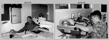
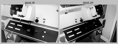
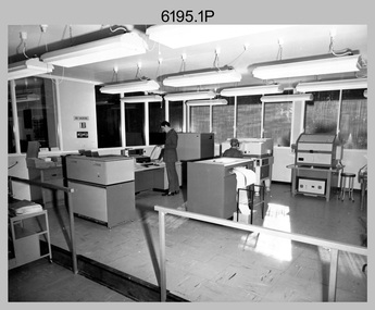
Photograph - Aerotriangulation Production – Army Survey Regiment, Fortuna, Bendigo, c1989
... The Zeiss (Jena) Stecometer analytic stereocomparator for air photography shown in photo .16P was introduced at Air Survey Squadron in 1963. ...The Zeiss (Jena) Stecometer analytic stereocomparator for air photography shown in photo .16P was introduced at Air Survey Squadron in 1963. ...This collection of 17 photographs of Air Survey Squadron aerotriangulation equipment and personnel was taken at the Army Survey Regiment, Fortuna, Bendigo, circa 1989. The PDP 11/70 minicomputer was the operating system introduced in 1977 as the mainframe system for the control of the APC4, aerial triangulation block adjustments, SORA OP Analytical Orthophoto control, APR Analytical Terrain Profile Recorder computation, graphics, and general computing. The OMI/Nistri AP/C-3 analytical plotter shown in photo .1P to .6P and .9P was introduced in 1972–1973. The Zeiss (Jena) Stecometer analytic stereocomparator for air photography shown in photo .16P was introduced at Air Survey Squadron in 1963. Aerotriangulation production was expedited using computers for analytical photogrammetric processes. The technician accurately measured between pass, tie, and survey control points on aerial photographs. Wild PUG4 point transfer devices as shown in photo .17P, were introduced in c1968 superseding the PUG2 devices. PUG4 devices were used by technicians to stereoscopically view the photography containing the survey control points and the mapping aerial photography. The Control points were transferred from the control photography to the mapping diapositives of aerial photography by drilling their locations into the photographic emulsion. See item 6195.19P for more photos of aerotriangulation equipment and their operation in map production.This is a set of 17 photographs of Air Survey Squadron aerotriangulation equipment and personnel taken at the Army Survey Regiment at Fortuna, Bendigo, circa 1989. The photographs are on 35mm negative film and scanned at 96 dpi. They are part of the Army Survey Regiment’s Collection. .1) to .7) - Photo, black & white, c1989, OMI/Nistri APC/3-1 analytical stereoplotter. .8) - Photo, black & white, c1989, miscellaneous aerotriangulation equipment. .9) to.10) - Photo, black & white, c1989, Digital Equipment Corporation (DEC) 11 VO3-L Superminicomputer, with VT52 DECScope terminal. .11) to .15) - Photo, black & white, c1989, miscellaneous aerotriangulation equipment. .16) - Photo, colour, c1989, Zeiss (Jena) Stecometer, unidentified technician. .17) - Photo, black & white, c1989, Wild PUG4 point transfer device, unidentified technician..1P to .17P – There are no annotationsroyal australian survey corps, rasvy, fortuna, army survey regiment, air survey, aerotrig -
 Mission to Seafarers Victoria
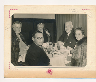
Photograph - Gelatin silver photograph, c. 1960
... On the reverse "Fully air-conditioned" and "Photography by Renouf of Marios'" is printed in red ink. ...On the reverse "Fully air-conditioned" and "Photography by Renouf of Marios'" is printed in red ink. ...The photograph shows five seated individuals dining at Marios' restaurant in Carlton, Melbourne. The ladies are wearing finery and corsages which suggests that this may have been a post-marriage celebration following the wedding of Lillie and James Morgan. Their marriage certificate records the date as 26th of April, 1969.This is a photograph of social and historic significance, being part of a sub-collection of material that provides a snapshot of the type of individuals involved in the Ladies Harbour Lights Guild and the activities carried out by that organisation. The image is also an insight into fashions of the time as well as into the relationship between Lillie and James.A professional photograph of Lillie Morgan (nee Duncan) and husband James Morgan dining at Marios' restaurant in Melbourne with three unidentified friends. The printed image is professionally mounted in a Marios' display folder.The front of the display folder reads "Greetings from Marios' Continental Restaurant Melbourne - Australia" Insignia of the restaurant is printed beneath the photograph and the photographer's name 'Renouf' is printed alongside. On the reverse "Fully air-conditioned" and "Photography by Renouf of Marios'" is printed in red ink. There is also a sketch in blue biro of a cat and a horse and rider.lillie duncan, lillie morgan, james morgan, marios', 1960s -
 Bendigo Military Museum
Photograph - Aerotriangulation Production – Army Survey Regiment, Fortuna, Bendigo, c1979
... The Zeiss (Jena) Stecometer analytic stereocomparator for air photography shown in photos .5P to .9P was introduced at Air Survey Squadron in 1963. ...The Zeiss (Jena) Stecometer analytic stereocomparator for air photography shown in photos .5P to .9P was introduced at Air Survey Squadron in 1963. ...This collection of 19 photos was most likely taken in 1979 in Air Survey Squadron. The PDP 11/70 minicomputer shown in photos .2P to .3P was the operating system introduced in 1977 as the mainframe system for the control of the APC4, aerial triangulation block adjustments, SORA OP Analytical Orthophoto control, APR Analytical Terrain Profile Recorder computation, graphics, and general computing. The Zeiss (Jena) Stecometer analytic stereocomparator for air photography shown in photos .5P to .9P was introduced at Air Survey Squadron in 1963. Aerotriangulation production was expedited using computers for analytical photogrammetric processes. The technician accurately measured between pass, tie, and survey control points on aerial photographs. The OMI/Nistri AP/C-3 analytical plotter shown in photos .10P and .11P was introduced in 1972–1973. Photo .11P shows a coordinatorgraph attached to the AP/C-3. The Zeiss D2 Planimat Stereoplotter shown in photo .12P was used for analytical orthophoto control. Wild PUG4 point transfer devices shown in photos .17P to .19P were introduced in c1968 superseding the PUG2 devices. PUG4 devices were used by technicians to stereoscopically view the photography containing the survey control points and the mapping aerial photography. The Control points were transferred from the control photography to the mapping diapositives of aerial photography by drilling their locations into the photographic emulsion.See item 9045.17P for more photos of aerotriangulation equipment and their operation in map production.This is a set of 19 photographs of Air Survey Squadron personnel operating aerotriangulation equipment at the Army Survey Regiment at Fortuna, Bendigo, c1979. Black and white photos are on photographic paper and were scanned at 300 dpi. They are part of the Army Survey Regiment’s Collection. .1) - Photo, black & white, c1979, Aerotriangulation tasks, unidentified technicians. .2) to .3) - Photo, black & white, c1979, PDP-11 minicomputers tasks, unidentified technician. .4) - Photo, black & white, c1979, Aerotriangulation tasks, unidentified technician. .5) - Photo, colour, c1979, Zeiss (Jena) Stecometer, unidentified technician. .6) to.9) - Photo, black & white, c1979, Zeiss (Jena) Stecometer, unidentified technician. .10) - Photo, black & white, c1984, OMI/Nistri APC/3-1 analytical stereoplotter, SPR Kristin (Isaac) Skidmore. .11) - Photo, colour, c1979, OMI/Nistri APC/3-1 analytical stereoplotter, unidentified technician. .12) - Photo, colour, c1979, Zeiss D2 Planimat Stereoplotter, unidentified technician. .13) - Photo, black & white, c1979, Aerotriangulation tasks, unidentified technician. .14) - Photo, black & white, c1979, Aerotriangulation tasks, unidentified technician. .15) - Photo, black & white, c1979, Aerotriangulation tasks, CPL Ken Talbot-Smith .16) - Photo, black & white, c1979, Aerotriangulation tasks, SPR David Jobe. .17) - Photo, black & white, c1979, Wild PUG4 point transfer device, WO2 Brian Mead. .18) - Photo, black & white, c1979, Wild PUG4 point transfer device, CPL Andy Wilson. .19) - Photo, black & white, c1979, Wild PUG4 point transfer device, unidentified technician..5P is annotated ‘OMI-Nistri AP/C Analytical Plotter’ and ’Topo 36’. .12P is annotated ‘Zeiss Jena Stecometer Stereocomparator’ and ’Topo 35’. There are no annotations on the other photos.royal australian survey corps, rasvy, army survey regiment, army svy regt, fortuna, asr, aerotrig, air survey -
 Bendigo Military Museum
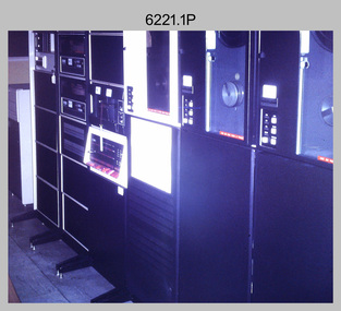
Photograph - Aerotriangulation Production – Army Survey Regiment, Fortuna, Bendigo, c1970s to 1980s
... It was introduced in 1972-1973 The Zeiss (Jena) Stecometer analytic stereocomparator for air photography shown in photos .5P to .11P and .14P was introduced at Air Survey Squadron in 1963. ...It was introduced in 1972-1973 The Zeiss (Jena) Stecometer analytic stereocomparator for air photography shown in photos .5P to .11P and .14P was introduced at Air Survey Squadron in 1963. ...This collection of 14 photos was most likely taken in the 1970s and 1980s in Air Survey Squadron. The PDP 11/70 minicomputer shown in photo .1P was the operating system introduced in 1977 as the mainframe system for the control of the APC4, aerial triangulation block adjustments, SORA OP Analytical Orthophoto control, APR Analytical Terrain Profile Recorder computation, graphics, and general computing. Technicians used the Wild A9 Stereocomparator shown in photo .2P to accurately measure between pass, tie, and survey control points on aerial photographs. The Zeiss D2 Planimat Stereoplotter shown in photos .3P to .4P was used for analytical orthophoto control. It was introduced in 1972-1973 The Zeiss (Jena) Stecometer analytic stereocomparator for air photography shown in photos .5P to .11P and .14P was introduced at Air Survey Squadron in 1963. Aerotriangulation production was expedited using computers for analytical photogrammetric processes. The technician accurately measured between pass, tie, and survey control points on aerial photographs. Wild PUG4 point transfer devices shown in photos .12P to .13P were introduced in c1968 superseding the PUG2 devices. PUG4 devices were used by technicians to stereoscopically view the photography containing the survey control points and the mapping aerial photography. The Control points were transferred from the control photography to the mapping diapositives of aerial photography by drilling their locations into the photographic emulsion.This is a set of 14 photographs of Air Survey Squadron personnel operating aerotriangulation equipment at the Army Survey Regiment at Fortuna, Bendigo, c1970s to 1980s. Photographs .1P to .13P were on 35mm colour slide film and scanned at 96 dpi. Photograph.14P was printed on photographic paper and was scanned at 300 dpi. They are part of the Army Survey Regiment’s Collection. .1) - Photo, colour, c1979, PDP-11 minicomputer. .2) - Photo, colour, c1970s, Unidentified technician operating a Wild A9 Stereocomparator. .3) - Photo, colour, c1970s, Zeiss D2 Planimat Stereoplotter. .4) - Photo, colour, c1970s, Zeiss D2 Planimat Stereoplotter, unidentified technicians. .5) - Photo, colour, c1970s, Zeiss D2 Planimat Stereoplotter, SGT Christopher Wardley. .6) - Photo, colour, c1970s, Zeiss D2 Planimat Stereoplotter. .7) to.9) - Photo, colour, c1970, Zeiss (Jena) Stecometer, unidentified technicians. .10) to.11) - Photo, colour, c1988, SPR Toni Wright operating a Zeiss (Jena) Stecometer. .12) - Photo, colour, c1970s, Wild PUG4 point transfer device, SPR John Shepard. .13) - Photo, colour, c1970s, Wild PUG4 point transfer device, SPR David Edwards. .13) - Photo, colour, c1970s, Wild PUG4 point transfer device, SPR David Edwards. .14) - Photo, colour, c1980, Zeiss (Jena) Stecometer, SGT Bruce Hammond.Some of the equipment is annotated on the frame of the 35mm slides.royal australian survey corps, rasvy, army survey regiment, army svy regt, fortuna, asr, aerotrig, photogrammetry -
 Bendigo Military Museum
Administrative record - Advisory Committee on Commonwealth Mapping Meeting Notes - (National Mapping Council Meetings), Circa 1972
... Submission 8 National Mapping Survey and Mapping Co-ordination. .4 Air photography and Mapping Programme 1956/57. ...Submission 8 National Mapping Survey and Mapping Co-ordination. .4 Air photography and Mapping Programme 1956/57. Signed by LF Fitzgerald OBE Director of Military Survey 26 Jan 56. .5 Letter Hon WS Kent Hughes MVO, OBE, MC, ED, MP. ...Advisory Committee on Commonwealth Mapping (ACOCM) Meeting Notes. 15 Items of typed pages and diagrams. .1 Letter to the Hon WS Kent Hughes MVO, OBE, Mc, ED, MP, Minister for the Interior, ACT Signed Jos Francis. Cabinet Decision taken on 22 July 1954, effects on current military mapping agreements between AUS, UK and USA. Australian responsibility "Noted was the fact that RASvy was in preparation for War." .2 Letter by H Wells Lieutenant General, Chief of the General Staff, 17 Feb 1955. Refers to the invitation of Major General RL Brown UK Defence to visit Australia to help align the mapping programme. .3 Draft Cabinet Submission on National Mapping Survey and Mapping Co-ordination of the 22 July 1955. Attachment 1 Cabinet Minute, Vice-President's letter Canberra22 July 1954. Decision No2 (VP). Submission 8 National Mapping Survey and Mapping Co-ordination. .4 Air photography and Mapping Programme 1956/57. Signed by LF Fitzgerald OBE Director of Military Survey 26 Jan 56. .5 Letter Hon WS Kent Hughes MVO, OBE, MC, ED, MP. Minister for the Interior ACT. Confirming the Cabinet Decision No2 (VP) Signed by Joe Francis .6 National Mapping Programme 1956/57. States a view to Army's contribution to this programme .7 Clarifies Army participation in Cabinet Decision No2 (VP) .8 History of National Mapping Asst Secretary (General) 24 Apr 1958 .9 Report on Army Committee on National Mapping. 2 July 1958 .10 RASvy Brief Review of Activities Jan - Dec 1964 .11 Advisory Committee on Commonwealth Mapping Meeting Notes 12 Feb 1965 - Agenda item 8. This endorsed the principle of grouping Commonwealth Mapping Agencies in a Survey Mapping Group in Canberra which included AHQ Survey Regiment. This did not come to fruition. .12 Advisory Committee on Commonwealth Mapping Meeting Notes 12 Feb 1965 - Agenda item 8 para 5.1.3 - 11.2 .13 ACOCM Meeting Agenda 1968 .14 ACOCM Meeting Minutes 1970 .15 Letter to Mr B White CBE Secretary from LF BottAdvisory Committee on Commonwealth Mapping (ACOCM) Meeting Notes. 15 Items of typed pages and diagrams. .1 Letter 22 July 1954 .2 Letter 17 Feb 1955 .3 Letter 22 July 1955 .4 letter 26 Jan 1956 .5 Letter Hon WS Kent Hughes Minister for the Interior ACT .6 National Mapping Programme 1956/57 .7 Clarifies Army participation in Cabinet Decision No2 (VP) .8 History of National Mapping 24 Apr 1958 .9 Report on Army Committee on National Mapping 2 July 1958 .10 RASvy Brief Review of Activities Jan - Dec 1964 .11 Advisory Committee Meeting Notes 12 Feb 1965 - Agenda item 8 .12 Advisory Committee Meeting Notes 12 Feb 1965 - Agenda item 8 para 5.1.3 - 11.2 .13 ACOCM Meeting Agenda 1968 .14 ACOCM Meeting Minutes 1970 .15 Letter to Mr B White CBE Secretary from LF Bottroyal australian survey corps, rasvy, fortuna, army survey regiment, army svy regt, asr, national mapping -
 Moorabbin Air Museum
Document (series) - Nomad Development Material - Collection of Vilem Gottlieb
... 106 Nomad Nomad Series N22 Maintenance Manual figure 203 - Horizontal Stabiliser Trim Control System 107 Nomad Nomad series N22 - N24 108 Map of Portartlington 109 Folder Nomad GAF Nomad N22B Float Plan - Performance Summary 1981 110 Disc Case Nomad 5 computer discs 111 Disc Case 5 computer discs 112 Metal Plate Nomad GAF N24A - 98F 113 Folder Engineering Standard Method for Weighing Aircraft with Portable Electronic Weighing Kits 1988 114 Stapled book Hartzell Propellor Inc Blade Specifications 1981 115 Nomad GAF Brochure: Nomad - The Australian N22B and N24A Turboprop 116 Bound book Nomad ASTA Nomad Performance Torque Charts - N24A-21021 1992 117 Photocopy Nomad SFTE Copy of article: Australian Searchmaster II Delivered to United States - Volume 21, January 1990 1990 118 Photography Nomad Air Safaris Nomad N24A near Mt Cook New Zealand 119 Bound book Nomad GAF N22C - Nomad Performance Summary for DOA Normal Catagory (sic) Operations 120 Stapled book Nomad GAF N24A - Performance Summary for Air Taxi and Commercial Operations to United States FAA/FAR 135 121 Technical Drawings Nomad N22A 122 Bound book Nomad ASTA Acceptance Test Schedule for Nomad N22S Searchmaster Series II Aircraft (does not include radar or FLIR) 1989 123 Manila Folder Nomad GAF Folder of paperwork pertaining to the delivery of aircraft to US Customs 1987 124 Suspension folder Nomad ASTA Project Note N2/120 - Nomad Horizontal stabiliser report 1991 125 Nomad ASTA Army Nomad Modification Program - Acceptance Test Plan 1991 126 Nomad ASTA Memo: Discussion points raised by ARDU 1991 127 Nomad ASTA Minute: NMP Acceptance Test Plan (ATP) 1991 128 Suspension folder Copies of the Civil Aviation Regulations 129 Blank Aircraft weighing and balance sheets 130 Print out of the Computerised track and balance for the H60 helicopter 1989 131 ASTA Letter: Seahawk Flying program 1990 132 ASTA Letter: Training for panel operator 1990 133 ASTA Memo: RAN Seahawk flight operations role 1990 134 Memo: Avionics Course detail 1990 135 Bound book Jetstream Handley Page Flight Manual 1972 136 Bound book Jetstream Handley Page Flight Manual 1969 137 Folder Jetstream Lots of Jetstream data and papers 138 Suspension folder American Jet Industries Publication/brochure 139 Metro II Swearingen Brochure: Metro II by Swearingen 140 Cheyenne IIIA Piper Aircraft Specifications and Performance 19855 141 Australian Light Wing Howard Huges Engineering Brochure: Australian Light Wing 1993 142 SAAB MFI 15 SAAB Brochure: SAAB MFI 15 King Air Exec-Liner Beechcraft Brochure: Beechcraft King Air Exec-Liner 1986 International Corporate Aviation Publication: British Aerospace 125-800 Turbine Islander Article: Turbine Islander in the air 1981 ...106 Nomad Nomad Series N22 Maintenance Manual figure 203 - Horizontal Stabiliser Trim Control System 107 Nomad Nomad series N22 - N24 108 Map of Portartlington 109 Folder Nomad GAF Nomad N22B Float Plan - Performance Summary 1981 110 Disc Case Nomad 5 computer discs 111 Disc Case 5 computer discs 112 Metal Plate Nomad GAF N24A - 98F 113 Folder Engineering Standard Method for Weighing Aircraft with Portable Electronic Weighing Kits 1988 114 Stapled book Hartzell Propellor Inc Blade Specifications 1981 115 Nomad GAF Brochure: Nomad - The Australian N22B and N24A Turboprop 116 Bound book Nomad ASTA Nomad Performance Torque Charts - N24A-21021 1992 117 Photocopy Nomad SFTE Copy of article: Australian Searchmaster II Delivered to United States - Volume 21, January 1990 1990 118 Photography Nomad Air Safaris Nomad N24A near Mt Cook New Zealand 119 Bound book Nomad GAF N22C - Nomad Performance Summary for DOA Normal Catagory (sic) Operations 120 Stapled book Nomad GAF N24A - Performance Summary for Air Taxi and Commercial Operations to United States FAA/FAR 135 121 Technical Drawings Nomad N22A 122 Bound book Nomad ASTA Acceptance Test Schedule for Nomad N22S Searchmaster Series II Aircraft (does not include radar or FLIR) 1989 123 Manila Folder Nomad GAF Folder of paperwork pertaining to the delivery of aircraft to US Customs 1987 124 Suspension folder Nomad ASTA Project Note N2/120 - Nomad Horizontal stabiliser report 1991 125 Nomad ASTA Army Nomad Modification Program - Acceptance Test Plan 1991 126 Nomad ASTA Memo: Discussion points raised by ARDU 1991 127 Nomad ASTA Minute: NMP Acceptance Test Plan (ATP) 1991 128 Suspension folder Copies of the Civil Aviation Regulations 129 Blank Aircraft weighing and balance sheets 130 Print out of the Computerised track and balance for the H60 helicopter 1989 131 ASTA Letter: Seahawk Flying program 1990 132 ASTA Letter: Training for panel operator 1990 133 ASTA Memo: RAN Seahawk flight operations role 1990 134 Memo: Avionics Course detail 1990 135 Bound book Jetstream Handley Page Flight Manual 1972 136 Bound book Jetstream Handley Page Flight Manual 1969 137 Folder Jetstream Lots of Jetstream data and papers 138 Suspension folder American Jet Industries Publication/brochure 139 Metro II Swearingen Brochure: Metro II by Swearingen 140 Cheyenne IIIA Piper Aircraft Specifications and Performance 19855 141 Australian Light Wing Howard Huges Engineering Brochure: Australian Light Wing 1993 142 SAAB MFI 15 SAAB Brochure: SAAB MFI 15 King Air Exec-Liner Beechcraft Brochure: Beechcraft King Air Exec-Liner 1986 International Corporate Aviation Publication: British Aerospace 125-800 Turbine Islander Article: Turbine Islander in the air 1981 Nomad Development Material - Collection of Vilem Gottlieb Document Nomad Development Material - Collection of Vilem Gottlieb ...Donation from Anna Gottlieb -
 Bendigo Military Museum
Administrative record - AHQ Fd Svy Sect (Sth Comd Det) - Air Photo Liaison draft notes 1950, 14 Mar 1950
... photography can be adhered to. Royal Australian Survey Corps RASvy Fortuna Army Survey Regiment Army Svy Regt ASR 4 x A4 pages of typed notes, poorly photocopied AHQ Fd Svy Sect (Sth Comd Det) - Air Photo Liaison draft notes 1950 Administrative record AHQ Fd Svy Sect (Sth Comd Det) - Air Photo Liaison draft notes 1950 AHQ Fd Svy Sect (Sth Cmd Det) ...These notes indicate that the "Standard Specification for Aerial Photography RASvy" be revised, and that all liaison personnel be issued with a copy so that the required standard of photography can be adhered to.4 x A4 pages of typed notes, poorly photocopiedroyal australian survey corps, rasvy, fortuna, army survey regiment, army svy regt, asr -
 Bendigo Military Museum
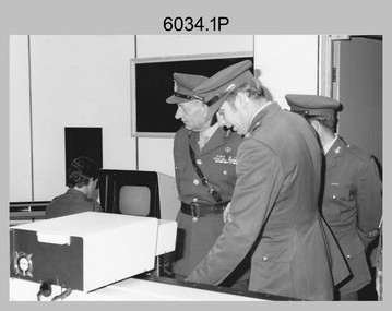
Photograph - Visit by the Chief of the General Staff to the Army Survey Regiment, Fortuna, Bendigo, 1979
... Air Survey Squadron. LTGEN General Sir Donald Dunstan AC, KBE, CB; views 3D stereoscopic aerial photography on a Zeiss (Jena) Stecometer. ...Air Survey Squadron. LTGEN General Sir Donald Dunstan AC, KBE, CB; views 3D stereoscopic aerial photography on a Zeiss (Jena) Stecometer. ...This is a set of 14 photographs of a visit to the Army Survey Regiment, Fortuna, Bendigo on the 5th of June 1979 by the Chief of the General Staff (CGS) Lieutenant General Sir Donald Dunstan AC, KBE, CB. He was accompanied by his wife. They were escorted through the production areas of the Army Survey Regiment by the CO LTCOL Bob Skitch. Lieutenant General Sir Donald Dunstan AC, KBE, CB was an esteemed Australian Army officer, who was CGS from 1977 to 1982. Upon retirement from the Army in 1982, he was appointed to the position of Governor of South Australia from 1982 to 1991. LTCOL Bob Skitch was the CO of the Army Svy Rgt from 1976 to 1980. Also featuring in these photos is MAJ Peter Eddy, who was the OC of Air Survey Squadron. He was later promoted to LTCOL and was CO of the Army Svy Rgt from 1981 to 1982. See item 6035.9P for photos of the CGS’s presentation of the Defence Force Service Medal to four recipients.This is a set of 14 photographs of a visit by the Chief of the General Staff to the Army Survey Regiment Fortuna, Bendigo on the 5th of June 1979. The photographs were printed on photographic paper and are part of the Army Survey Regiment’s Collection. They were scanned at 300 dpi. .1) - Photo, black and white, 1979. Tour of Air Survey Squadron. L to R: unidentified, LTGEN General Sir Donald Dunstan AC, KBE, CB; OC MAJ Peter Eddy, unidentified. .2) - Photo, black and white, 1979. Tour of Air Survey Squadron. LTGEN General Sir Donald Dunstan AC, KBE, CB; views 3D stereoscopic aerial photography on a Zeiss (Jena) Stecometer. OC MAJ Peter Eddy is on his right. .3) - Photo, black and white, 1979. Tour of Air Survey Squadron. L to R: unidentified, CO LTCOL Bob Skitch, OC MAJ Peter Eddy, LTGEN General Sir Donald Dunstan AC, KBE CB viewing an aerial photograph. WO1 Brian Mead and others are operating a Wild PUG4 point transfer device. .4) - Photo, black and white, 1979. Enlargement of photo .3). Tour of Air Survey Squadron. L to R: unidentified, CO LTCOL Bob Skitch, OC MAJ Peter Eddy, LTGEN General Sir Donald Dunstan AC, KBE CB viewing an aerial photograph. .5) - Photo, black and white, 1979. Tour of Air Survey Squadron. LTGEN General Sir Donald Dunstan AC, KBE, CB; and unidentified technician view 3D stereoscopic aerial photography on a Wild B8 stereo plotter. .6) - Photo, black and white, 1979. Tour of Air Survey Squadron. L to R: OC MAJ Peter Eddy LTGEN General Sir Donald Dunstan AC, KBE CB; CO LTCOL Bob Skitch, view the output of a verification plot on an AUTOMAP 1 Gerber 1442 drum plotter. .7) - Photo, black and white, 1979. Tour of Air Survey Squadron. L to R: CO LTCOL Bob Skitch, unidentified aide de camp officer, LTGEN General Sir Donald Dunstan AC, KBE CB; OC MAJ Peter Eddy discuss aero triangulation planning documents. CAPT Don Maskew in background. .8) - Photo, black and white, 1979. Tour of Cartographic Squadron. L to R: CPL Dennis Learmonth, acting OC CAPT Bob Roche, CAPT Eddy Schulze, LTGEN General Sir Donald Dunstan AC, KBE CB; SSGT John ‘JB’ Barrie discuss cartographic map compilation procedures .9) - Photo, black and white, 1979. Tour of Cartographic Squadron. L to R: Tech WO WO1 Roger Rix, acting OC CAPT Bob Roche, CAPT Eddy Schulze, unidentified visitor, Mrs Dunstan with examples of map products. .10) - Photo, black and white, 1979. Tour of Cartographic Squadron. L to R: CPL Terry Danger, CO LTCOL Bob Skitch, LTGEN General Sir Donald Dunstan AC, KBE CB; discuss terrain embossing (hill shading) procedures. .11) - Photo, black and white, 1979. Tour of Cartographic Squadron. L to R: CO LTCOL Bob Skitch, LTGEN General Sir Donald Dunstan AC, KBE CB; acting OC CAPT Bob Roche, SSGT Dick Manley, CAPT Don Maskew and CAPT Steve Cooper in background. SPR Cheryl Lofthouse is retouching blemishes on a map separation film negative. .12) - Photo, black and white, 1979. Tour of Lithographic Squadron. L to R: CAPT Stan Vote, unidentified aide de camp officer, CO LTCOL Bob Skitch, LTGEN General Sir Donald Dunstan AC, KBE CB; MAJ Sam Schwartz EXCH-US, LT John Harrison discuss bulk map printing processes with an Ultra-MAN-III Printing Press. .13) - Photo, black and white, 1979. Officers Mess L to R: LTGEN General Sir Donald Dunstan AC, KBE CB; with CO LTCOL Bob Skitch. .14) - Photo, black and white, 1979. Officers Mess L to R: MAJ Peter Eddy, LTGEN General Sir Donald Dunstan AC, KBE CB..1P to .14P – no annotationsroyal australian survey corps, rasvy, army survey regiment, army svy regt, fortuna, asr -
 Bendigo Military Museum
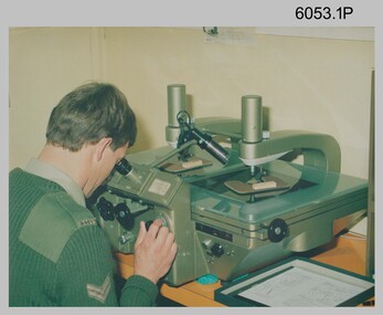
Photograph - Army Survey Regiment Map Production Equipment, c1980s, c1990s
... Air Survey Squadron c1980s. Control points were transferred onto the mapping diapositives of aerial photography by drilling their locations into the photographic emulsion. ...Air Survey Squadron c1980s. Control points were transferred onto the mapping diapositives of aerial photography by drilling their locations into the photographic emulsion. ...Photos .1P, .2P, and.4P were most likely taken in the 1980s and photos .3P, .5P to .8P in the c1990s at the Army Survey Regiment, Fortuna, Bendigo. Despite lacking annotation on exact dates, locations and personnel, they are positively identified. CPL Ian Nelson in photo .1P is operating a Wild Pug 4 point transfer device in Air Survey Squadron c1980s. Control points were transferred onto the mapping diapositives of aerial photography by drilling their locations into the photographic emulsion. SPR Viv (Hawkins) Doherty in photo .2P, SPR Jeanette Drury-Lane in photo .5P and SGT Sandy Craig are operating a Wild B8 Stereoplotter coupled to a digital workstation in Air Survey Squadron c1994. Topographic features were extracted with the B8 in 3D and feature coded with attributes, using keyboard, menu, keypad and voice inputs to the computer. The features were stored in the AUTOMAP 2 digital database for subsequent cartographic production and printing. CPL Mick Ellis in photo .3P is operating the Optronix 4040 Scanner/Film Writer in Lithographic Squadron c1990s. In scanning mode, compilation sheets were mounted on the drum and scanned. The resultant raster file was vectorized, feature coded with attributes and stored by cartographic technicians in the AUTOMAP 2 database. In film writing mode, digital cartographic files were output at very high resolution for each print colour on photosensitive film, for subsequent finalisation, platemaking and printing.This is a set of eight photographs of technicians operating map production equipment at the Army Survey Regiment, Bendigo. The photographs were printed on photographic paper and are part of the Army Survey Regiment’s Collection. The photographs were scanned at 300 dpi. Photo negatives were scanned at 2400 dpi. .1) - Photo, colour, c1980s. CPL Ian Nelson operating a Wild Pug 4 point transfer device in Air Survey Squadron. .2) - Photo, colour, c1980s. Wild B8 Aviograph stereoplotter feature extraction, SPR Viv (Hawkins) Doherty in Air Survey Squadron. .3) - Photo, colour, c1990s. CPL Mick Ellis operating the Optronics 4040 Scanner in Lithographic Squadron. .4) - Photo, colour, c1984. AUTOMAP 2 Graphic Edit Workstation, SPR Craig Kellet in Cartographic Squadron. .5) - Photo, colour, c1994. Wild B8 Aviograph stereoplotter feature extraction, SPR Jeanette Drury-Lane in Air Survey Squadron. .6) - Photo, colour, c1994. AUTOMAP 2 Graphic Edit Workstation, L to R: unidentified, SPR Rachel (Stanford) Scott, CPL Chris Wynn in Cartographic Squadron. .7) - Photo, colour, c1994. Wild B8 Aviograph stereoplotter AUTOMAP 2 Graphic Edit Workstation, L to R: unidentified (x2), SGT Sandy Craig in Air Survey Squadron. .8) - Photo, colour, c1994. AUTOMAP 2 Graphic Edit Workstation, L to R: unidentified, SPR Peter Smyth, SPR Frank Savy, SPR Quentin Seecamp, CPL Steve McGuiness in Cartographic Squadron. .1P – no annotations .2P – annotated “Stereoplotter Workstation. The operator has the use of keyboard, menu, keypad and voice for input to the computer. Feedback is given through voice and screen messages.” .3 to .8P – no annotationsroyal australian survey corps, rasvy, army survey regiment, army svy regt, fortuna, air survey, litho, aerotrig, automap 2 -
 Bendigo Military Museum
Administrative record - Royal Australian Survey Corps - Operation Sandy Bush Phase 3, Operation Instruction 8/75, 22 Sept 1975
... air. The positions of these crosses could then be accurately transferred from this new photography in stereo onto the aerial photography coverage used to produce mapping....air. The positions of these crosses could then be accurately transferred from this new photography in stereo onto the aerial photography coverage used to produce mapping. 8 Fd Svy Sqn RASvy Royal Australian Survey Corps Fortuna Army Survey Regiment Army Svy Regt Some annotations in top LH corner Typed Instructions and diagrams without cover, 14 x A4 pages stapled in Top Left Hand Corner. ...Operation Instruction 8/75, Operation Sandy Bush Phase 3 was conducted in the period 1 Oct to 30 Nov 1975 by Det A, 8 Fd Svy Sqn. The Operation was to complete the marking, panelling measurement of already marked control in the Louisiade and D'Entrecasteaux groups and to Recce, Mark, Panel and Measure new survey control in the Trobriand and Woodlark Islands. In addition Photo Identification was to be obtained of all marked survey control. Panelling was the process of accurately laying out large sheets of white plastic to form a cross over the Survey Control Points (Points where the position is accurately known) so that they could then be photographed from the air. The positions of these crosses could then be accurately transferred from this new photography in stereo onto the aerial photography coverage used to produce mapping.Typed Instructions and diagrams without cover, 14 x A4 pages stapled in Top Left Hand Corner.Some annotations in top LH corner8 fd svy sqn, rasvy, royal australian survey corps, fortuna, army survey regiment, army svy regt -
 Bendigo Military Museum
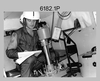
Photograph - Royal Australian Survey Corps Aerial Surveys, c1980
... The Wild RC10 super wide-angle air survey cameras were first introduced in 1971, were equipped with virtual distortion free lenses for supplementary, spot and special photography. ...The Wild RC10 super wide-angle air survey cameras were first introduced in 1971, were equipped with virtual distortion free lenses for supplementary, spot and special photography. ...This is a set of nine photographs of technicians from the Royal Australian Survey Corps operating aerial surveys equipment c1980s. In photo .1P, CPL Steve Gloster was operating a RC10 air survey camera mounted in an Australian Army Pilatus Porter aircraft. The Wild RC10 super wide-angle air survey cameras were first introduced in 1971, were equipped with virtual distortion free lenses for supplementary, spot and special photography. In photo .2P, Roger Rees was operating Air Profile Recorder (APR) equipment. it was possibly taken during OP NERVOSE 84, sometime between June – August 1984 when based in Ngukurr, Northern Territory. The APR was operated at this time in unison with an RC10 camera. In 1963 the Royal Australian Survey Corps introduced the radar airborne profile recorder (Canadian Applied Research Ltd, Mark V, Airborne Profiler Recorder) was introduced for 1:100,000 mapping to replace terrain heighting by aneroid barometry. Later in 1974-1975, the Australian developed WREMAPS II airborne laser terrain profile recorder was introduced. In photo .3P, Neil Jones appears at the door of Airsearch Beechcraft Queen Air aircraft, Registration / Serial VH-MWX. This aircraft was typically used by RA Svy on air survey operations flying mission with Aerodist, APR and RC10 camera equipment. The Australian Army’s Pilatus Porter (short take-off and landing turbo propeller) was also equipped with a Wild RC10 aerial mapping camera for identification photography. The Pilatus Porter was also used on RA Svy’s map field checking operations. Photo .9P was taken at a survey station at an unknown location. In this photo an Australian Army Kiowa Light Observation Helicopter (LOH) is supporting a field survey party undertaking Magnavox AN/PRR-14 portable Doppler satellite observations. The satellite receiver’s antenna is plumbed over the survey ground mark surrounded by white plastic panels. The panels were used to identify the survey station on aerial photography. Introduced in 1974–1975, the Magnavox AN/PRR-14 portable Doppler satellite (US Navy Navigation Satellite System – TRANSIT) receivers and computing system provided independent three-dimensional point positions anywhere in the world, anytime, in any weather accurate to about 1.5metres with precise satellite ephemerides. The Bell OH-58 Kiowa LOH was a family of military helicopters used for observation, utility, and direct fire support. It was identified by RA Svy in the mid-1970s that considerable time was lost in replacing unserviceable remote equipment by road. Therefore Aerodist operations (pre-dating satellite receiver operations) were fully supported by Army’s Kiowa LOH aircraft. This is a set of nine photographs of technicians from the Royal Australian Survey Corps operating aerial surveys equipment c1980s. .1P to .3P, .5P to .9P - Colour and black and white photos on photographic paper and scanned at 300 dpi. .4P - Colour photo on 35mm slide film and scanned at 96 dpi. .1) & .2) - Photo, black & white, c1980s, CPL Steve Gloster operating an RC10 air camera. .3) - Photo, colour, 1984, Roger Rees operating Air Profile Recorder (APR) equipment. .4) - Photo, colour, c1980s, Neil Jones at the door of an Airsearch Beechcraft Queen Air aircraft, typically used by RA Svy on air survey operations. .5) - Photo, colour, c1980s. A Beechcraft King Air aircraft, also used by RA Svy on air survey operations. .6) - Photo, colour, c1980s. An Australian Army Pilatus Porter, used by RA Svy on air survey and map field checking operations. SGT Peter Mustart is possibly in the foreground. .7) to .8) - Photo, colour, c1980s. An Australian Army Pilatus Porter and unidentified personnel, used by RA Svy on air survey and map field checking operations. .9) - Photo, colour, c1980s. An Australian Army Kiowa helicopter supporting a field survey party undertaking Magnavox AN/PRR-14 portable Doppler satellite observations. There are biro marks on photos .4P to .9Proyal australian survey corps, rasvy, army survey regiment, asr, fortuna, aerial surveys -
 Bendigo Military Museum
Photograph - SUNDERLAND PHOTO, Post 1943
... Refer Cat No 3627.5 for his service details. photography sunderlands military On rear, “ BRITISH OFFICIAL PHOTOGRAPH, No CH 3210 Air Ministry photograph - crown copyright reserved. ...Item in the collection of Reginald Charles Allardice No 418557 RAAF. Refer Cat No 3627.5 for his service details.Aerial B & W photo of a Sunderland Flying Boat over land. On the rear a paper is pasted to with typed writing in purple.On rear, “ BRITISH OFFICIAL PHOTOGRAPH, No CH 3210 Air Ministry photograph - crown copyright reserved. On patrol, a short Sunderland Flying Boat of the RAF Coastal Command sets out on a patrol. This particular aircraft is flown by the RAAF Squadron operating with Coastal Command The Sqd is on the 9,000 hours flying mark during its 16 months operating duty in this country”photography, sunderlands, military -
 Bendigo Military Museum
Photograph - PHOTOGRAPH RAAF WW2, 1939 - 1946
... History of site written on rear of photo in biro. photography aerial photos Mallala On rear - "No. 6 Service Flying Training School, RAAF, Mallala" Air photo of RAAF base. ...Item in the collection re Maxwell Matheson RAAF. History of site written on rear of photo in biro.Air photo of RAAF base. Mounted on cardboard. No. 6 service flying training school, Mallala SA. Large writer description. Photo shows very large quantity of Avro Ansons, revetments & building.On rear - "No. 6 Service Flying Training School, RAAF, Mallala"photography, aerial photos, mallala -
 Bendigo Military Museum
Photograph - PHOTOGRAPH WW2, C. WW2
... photography-photographs...military history - air...Bendigo Military Museum 37 - 39 Pall Mall Bendigo goldfields photography-photographs military history - air force Passchendaele barrracks trust Portrait of an airman in uniform, no rank shown. ...Portrait of an airman in uniform, no rank shown. Has an air crew 1/2 wing badge on chest. Photo has been glued onto a breakfast cereal packet.photography-photographs, military history - air force, passchendaele barrracks trust -
 Bendigo Military Museum
Photograph - PHOTOGRAPH WW2, FRAMED, C.1939 - 45
... photography-photographs...military history - air...Bendigo Military Museum 37 - 39 Pall Mall Bendigo goldfields photography-photographs military history - air force Passchendaele barracks trust Colour photo in wooden frame, is a head portrait of an airman wearing a peaked cap. ...Colour photo in wooden frame, is a head portrait of an airman wearing a peaked cap.photography-photographs, military history - air force, passchendaele barracks trust -
 Bendigo Military Museum
Photograph - PHOTOGRAPH, AIR FORCE, C.1939 - 45
... photography-photographs...military history - air...Bendigo Military Museum 37 - 39 Pall Mall Bendigo goldfields photography-photographs military history - air force Passchendaele Barracks Trust Photo, black & white, showing a Sunderland Aircraft. ...Photo, black & white, showing a Sunderland Aircraft. On its wings & in front of it are a large number of airmen. The aircraft is in front of a camouflaged hanger. The photo is glued to a Weeties packet.photography-photographs, military history - air force, passchendaele barracks trust -
 Bendigo Military Museum
Photograph - PHOTOGRAPH, AIRFORCE, c. 1939 - 45
... photography-photographs...military history - air...Bendigo Military Museum 37 - 39 Pall Mall Bendigo goldfields photography-photographs military history - air force Passchendaele Barracks Trust The photo shows three of the four engines of the Sunderland. ...The photo shows three of the four engines of the Sunderland. There are about 70 airmen in front of the aircraft.photography-photographs, military history - air force, passchendaele barracks trust -
 Bendigo Military Museum
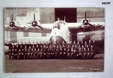
Photograph - PHOTOGRAPH, AIRFORCE, C. WW2 onwards
... photography-photographs...military history - air...Bendigo Military Museum 37 - 39 Pall Mall Bendigo goldfields photography-photographs military history - air force Passchendaele Barracks Trust Photo, black & white, showing Sunderland Aircraft floating on water, 4 air crew on top of wing, engines undergoing maintenance. ...Photo, black & white, showing Sunderland Aircraft floating on water, 4 air crew on top of wing, engines undergoing maintenance.photography-photographs, military history - air force, passchendaele barracks trust -
 Bendigo Military Museum
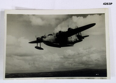
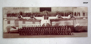
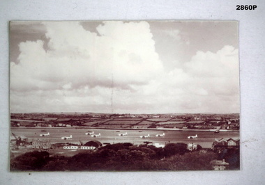
Photograph - PHOTOGRAPH, AIR FORCE, C. WW2 onwards
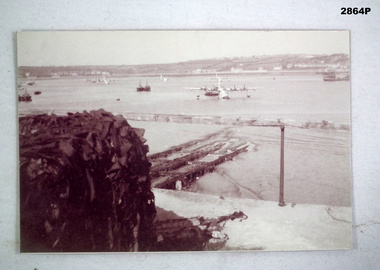
... photography-photographs...military history - air...Bendigo Military Museum 37 - 39 Pall Mall Bendigo goldfields photography-photographs military history - air force Sunderland Passchendaele Barracks Trust Photo, black & white, this is a distant shot showing patchy/cloudy sky. ...Photo, black & white, this is a distant shot showing patchy/cloudy sky. There is a waterway in the centre with 8 Sunderland Aircraft moored in it. The Tactical Air Command are facing left. The foreground shows buildings, a crane & trees.photography-photographs, military history - air force, sunderland, passchendaele barracks trust -
 Bendigo Military Museum
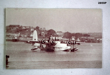
Photograph - PHOTOGRAPH, AIRFORCE, c.WWII
... photography-photographs...military history - air...Bendigo Military Museum 37 - 39 Pall Mall Bendigo goldfields photography-photographs military history - air force Passchendaele Barracks Trust Photo, black & white, showing a waterway with several Sunderland Air Craft moored, some boats & shipping. ...Photo, black & white, showing a waterway with several Sunderland Air Craft moored, some boats & shipping. On left in foreground shows a large object covered in some sort of camouflage.photography-photographs, military history - air force, passchendaele barracks trust -
 Bendigo Military Museum
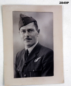
Photograph - PHOTOGRAPH WW1, C.1917
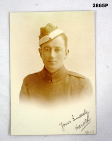
... photography-photographs...military history - air...Bendigo Military Museum 37 - 39 Pall Mall Bendigo goldfields photography-photographs military history - air force Passchendaele barracks trust Bottom: "Yours sincerely Harold 22.1.17" Photo, black & white, a chest up portrait of a young man in what appears to be the Flying Corps uniform. ...Photo, black & white, a chest up portrait of a young man in what appears to be the Flying Corps uniform. He is wearing a fore & aft forage cap with light coloured band.Bottom: "Yours sincerely Harold 22.1.17"photography-photographs, military history - air force, passchendaele barracks trust -
 Bendigo Military Museum
Photograph - PHOTOGRAPH WW1, C. 1917 onwards
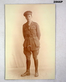
... photography-photographs...military history - air...Bendigo Military Museum 37 - 39 Pall Mall Bendigo goldfields This is possibly a British Flying Corp unit. photography-photographs military history - air force AFC Passchendaele barracks trust Photo, black & white, showing a WW1 Flying Corp Officer standing. ...This is possibly a British Flying Corp unit.Photo, black & white, showing a WW1 Flying Corp Officer standing. He is wearing a Sam Browne belt, lace up knee boots and a peaked cap.photography-photographs, military history - air force, afc, passchendaele barracks trust -
 Bendigo Military Museum
Photograph - BADGE PHOTOGRAPH, Possible post WW1
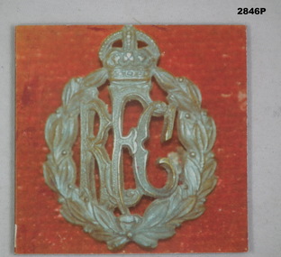
... photography-photographs...military history - air...Bendigo Military Museum 37 - 39 Pall Mall Bendigo goldfields Wording is most likely “Royal Flying Corp” photography-photographs military history - air force Passchendaele barracks trust Photo, colour, showing the RFC Badge. ...Wording is most likely “Royal Flying Corp”Photo, colour, showing the RFC Badge. Red background the RFC Badge has the 3 RFC letters surrounded by oak leaves, a crown surmounts the lot.photography-photographs, military history - air force, passchendaele barracks trust