Showing 1565 items matching "allotment"
-
 Emerald Museum & Nobelius Heritage Park
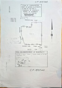
Map - Plan of Consolidation part of Crown Allotments 51 & 10B, Section A, Township of Emerald, Parish of Gembrook, County of Evelyn, Plan of consolidation for government allotment in Emerald, sealed on 19 November, 1984 (Property later to be known as Nobelius Heritage Park, Emerald), c1984
... Plan of consolidation for government allotment in Emerald, sealed on 19 November, 1984 (Property later to be known as Nobelius Heritage Park, Emerald)...Image of Plan of Consolidation of Crown Allotments in township of Emerald...CP159745, Plan of Consolidation Part of Crown Allotments 51 & 10B Section A, Township of Emerald, Parish of Gembrook, County of Evelyn, area bounded by Emerald Lake Rd., Princess Avenue, Crichton Rd., Kings Avenue. ...Seal and endorsement of municipality - this plan is sealed puRsuant to Section 569AB of the Local Government Act, dated 19th November, 1984, (Property later to be known as Nobelius Heritage Park, Emerald) Image of Plan of Consolidation of Crown Allotments in township of Emerald Plan of consolidation for government allotment in Emerald, sealed on 19 November, 1984 (Property later to be known as Nobelius Heritage Park, Emerald) Map Plan of Consolidation part of Crown Allotments 51 & 10B, Section A, Township of Emerald, Parish of Gembrook, County of Evelyn ...Image of Plan of Consolidation of Crown Allotments in township of Emeraldnon-fiction -
 Ringwood and District Historical Society
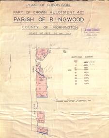
Map - Plan of Subdivision, Part of Crown Allotment 40C, Parish of Ringwood, County of Mornington - (Undated, circa 1940s)
... Part of Crown Allotment 40C, Parish of Ringwood, County of Mornington - (Undated, circa 1940s)...Copy of land title map in manilla folder showing layout and size of residential allotments in Allens Road Heathmont, Victoria....Typewritten sales notations attached for some allotments with rubber stamp impression - H.G. ...Typewritten sales notations attached for some allotments with rubber stamp impression - H.G. ...Copy of land title map in manilla folder showing layout and size of residential allotments in Allens Road Heathmont, Victoria.J.S. Watson & Associates, Surveyors & Chartered Engineers, 7 Main Street Mornington, (Tel) Mornington 86. Typewritten sales notations attached for some allotments with rubber stamp impression - H.G. McLean, Builder, 5 Whitehorse Road, Ringwood. -
 Ringwood and District Historical Society
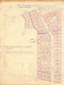
Map - Plan of Subdivision, Part of Crown Allotment 27 & 27B, Parish of Ringwood - (Undated, circa late 1950s)
... Part of Crown Allotment 27 & 27B, Parish of Ringwood - (Undated, circa late 1950s)...Copy of land title map in manilla folder showing layout and size of 60 allotments in Railway Avenue, Victoria Street, Smithdene Avenue, Richard Court, Jeanette Court, Bruce Court and Loma Street, Ringwood East, Victoria....Map includes handwritten sales notations for several allotments, e.g. Sold....Part of Crown Allotment 27 & 27B, Parish of Ringwood - (Undated, circa late 1950s) Map Plan of Subdivision ...Copy of land title map in manilla folder showing layout and size of 60 allotments in Railway Avenue, Victoria Street, Smithdene Avenue, Richard Court, Jeanette Court, Bruce Court and Loma Street, Ringwood East, Victoria.Note: Lot 15 is to be transferred to the Ringwood Borough Council for use as a children's playground. Map includes handwritten sales notations for several allotments, e.g. Sold. -
 Linton and District Historical Society Inc
Documents - purchase of land, Purchase of land by David McFadzean, 1872 - Allotment A1A, Township of Linton, Parish of Argyle
... Purchase of land by David McFadzean, 1872 - Allotment A1A, Township of Linton, Parish of Argyle...This allowed long-term tenants ("licensees") of government-held land to purchase ("alienate") the land. The allotment is in present-day Jackson Street, Linton....Twelve A4-size photocopies of documents relating to the purchase of an allotment of land - Allotment A1A, measuring 5 acres, 3 roods and 37 perches - within the boundaries of the Township of Linton. ...Allotment A1A Township of Linton David McFadzean Victoria. ...The land was purchased by David McFadzean under the 42nd section of the Amending Land Act, 1865. This allowed long-term tenants ("licensees") of government-held land to purchase ("alienate") the land. The allotment is in present-day Jackson Street, Linton.Twelve A4-size photocopies of documents relating to the purchase of an allotment of land - Allotment A1A, measuring 5 acres, 3 roods and 37 perches - within the boundaries of the Township of Linton. First page is headed "SECTION 31, "LAND ACT 1869". Documents include David McFadzean's application to purchase, notes made about the land and the application by officers of the Board of Land and Works, a plan of the allotment, and information about purchase price and fees.allotment a1a township of linton, david mcfadzean, victoria. amending land act 1865, conveyance, land sales, land purchases, documents and records, james beament -
 Emerald Museum & Nobelius Heritage Park
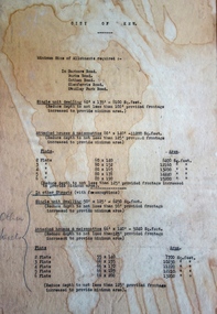
Map - Municipality Road Classification - Beaconsfield-Emerald Rd., Shire of Gembrook 1973, Title Survey Division, Crown Description - Part of Crown Allotment 44, Parish of Gembrook, County of Mornington, c1973
... Title Survey Division, Crown Description - Part of Crown Allotment 44, Parish of Gembrook, County of Mornington...Image of Crown Survey Map for crown allotment 44 (Beaconsfield-Emerald Rd.) parish of Gembrook, County of Mornington...Title Survey Division/Crown Description/Part of Crown Allotment 44, Parish of Gembrook, County of Mornington/Municipality Road Classification, Shire of Berwick, Beaconsfeld-Emerald Rd. ...(MR)/Francis J Webber of Kirkpatrick & Webber, 285 Maroondah Hwy., Ringwood/(Signed) - Principal Title Survey Office 16.1.73/SP13461 Image of Crown Survey Map for crown allotment 44 (Beaconsfield-Emerald Rd.) parish of Gembrook, County of Mornington Title Survey Division, Crown Description - Part of Crown Allotment 44, Parish of Gembrook, County of Mornington Map Municipality Road Classification - Beaconsfield-Emerald Rd., Shire of Gembrook 1973 ...Image of Crown Survey Map for crown allotment 44 (Beaconsfield-Emerald Rd.) parish of Gembrook, County of MorningtonTitle Survey Division/Crown Description/Part of Crown Allotment 44, Parish of Gembrook, County of Mornington/Municipality Road Classification, Shire of Berwick, Beaconsfeld-Emerald Rd. (MR)/Francis J Webber of Kirkpatrick & Webber, 285 Maroondah Hwy., Ringwood/(Signed) - Principal Title Survey Office 16.1.73/SP13461 -
 Bacchus Marsh & District Historical Society
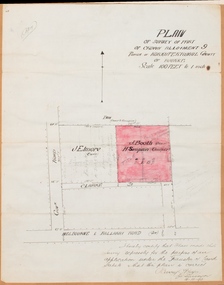
Map, Plan of Survey of Part of Crown Allotment 9, Parish of Korkuperrimul, 1890
... Plan of Survey of Part of Crown Allotment 9, Parish of Korkuperrimul, 1890...Simpson as the occupier. Next to this allotment is a an allotment of land owned by J. ...Single page map showing Crown allotment 9, Parish of Korkuperrimul, County of Bourke. ...Simpson as the occupier. Next to this allotment is a an allotment of land owned by J. ...This map documents a transfer of an allotment of land in Clarke Street Bacchus Marsh in 1890. Clarke Street is located on the eastern side of Bacchus Marsh not far from Main Street and Crook Street. It is now known as Candeloro Street. The map indicates J. Booth as the owner of the land and H. Simpson as the occupier. Next to this allotment is a an allotment of land owned by J. Elmore,Single page map showing Crown allotment 9, Parish of Korkuperrimul, County of Bourke. Scale 100 feet to inch. Part of a set of maps which are pasted into a bound volume containing 76 maps or plans in total. High resolution digital image stored on BMDHS computer network. At bottom of map: I hereby certify that I have made this survey expressly for the purpose of an application under the Transfer of Land Statute that this plan is correct. Barry B???, Lic. Surveyor, 16.10.90bacchus marsh victoria maps, clarke street bacchus marsh maps -
 Emerald Museum & Nobelius Heritage Park
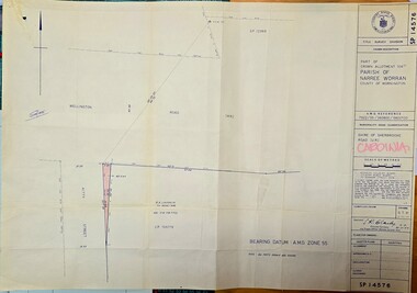
Map - Municipality Road Classification - Wellington Rd. (part), Crown Description - part of Crown Allotment 106 G1, Parish of Narree Worran, c1977
... Crown Description - part of Crown Allotment 106 G1, Parish of Narree Worran...Image of Title Survey, Part of Crown Allotment 106G1, Road Classification Shire of Sherbrooke Rd (Wellington Rd.)...SP14576/Title Survey Division/Crown Description/Part of Crown Allotment 106 G1, Parish of Narree Worran, County of Mornington/AMG Reference 7922/55/360800/5800100/Municipality Road Classification/Shire of Sherbrooke Road/Kenneth Douglas Adams, Country Roads Board, 60 Denmark Street, Kew, Surveyor, dated 15th November, 1977/Approved S.R. ...Crown Description - part of Crown Allotment 106 G1, Parish of Narree Worran Map Municipality Road Classification - Wellington Rd. ...Image of Title Survey, Part of Crown Allotment 106G1, Road Classification Shire of Sherbrooke Rd (Wellington Rd.)SP14576/Title Survey Division/Crown Description/Part of Crown Allotment 106 G1, Parish of Narree Worran, County of Mornington/AMG Reference 7922/55/360800/5800100/Municipality Road Classification/Shire of Sherbrooke Road/Kenneth Douglas Adams, Country Roads Board, 60 Denmark Street, Kew, Surveyor, dated 15th November, 1977/Approved S.R. CLARKE, Principal Surveyor and Proper Officer 21.11.77 -
Linton and District Historical Society Inc
Certificate of Title, Certificate of Title: Allotment 36, Section 4, Township of Linton
... Certificate of Title: Allotment 36, Section 4, Township of Linton....James and Theo Nelson had already purchased adjacent allotments 27 - 30 in 1929....Copy of a Certificate of Title for an allotment of land situated between Grantley Street and Springdallah Creek in Linton. ...James and Theo Nelson had already purchased adjacent allotments 27 - 30 in 1929. Certificates of Title Allotment 36 Section 4 Township of Linton James Adolphus Nelson Theophilus William Nelson Copy of a Certificate of Title for an allotment of land situated between Grantley Street and Springdallah Creek in Linton. ...Title of the land was transferred to James Adolphus Nelson and Theophilus William Nelson in 1955. James and Theo Nelson had already purchased adjacent allotments 27 - 30 in 1929.Copy of a Certificate of Title for an allotment of land situated between Grantley Street and Springdallah Creek in Linton. Copy comprised of three photostat sheets held together by tape. Most recent holders of the Title recorded as James Adolphus Nelson and Theophilus William Nelson.certificates of title, allotment 36 section 4 township of linton, james adolphus nelson, theophilus william nelson -
 Wonga Park Community Cottage History Group
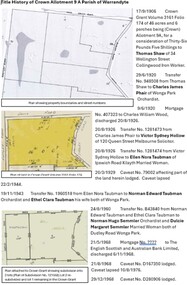
Document - Title History, Title History of Crown Allotment 9A Wonga Park
... Title History of Crown Allotment 9A Wonga Park...The allotment history for Crown allotment 9A Wonga Park (after Crown leases from 1893) starts in 1906 with the Crown granting 46 acres and 6 perches to Thomas Shaw, an iron worker in Collingwood. ...Archive file for Crown allotment 9A containing title history documents and research. ...Wonga Park Community Cottage History Group Unit 1, 9 – 13 Old Yarra Road Wonga Park melbourne The allotment history for Crown allotment 9A Wonga Park (after Crown leases from 1893) starts in 1906 with the Crown granting 46 acres and 6 perches to Thomas Shaw, an iron worker in Collingwood. ...The allotment history for Crown allotment 9A Wonga Park (after Crown leases from 1893) starts in 1906 with the Crown granting 46 acres and 6 perches to Thomas Shaw, an iron worker in Collingwood. The history of registered owners who have a connection with the allotment include Charles James Phair (1920), Victor Sydney Hollow, Ellen Nora Taubman, Norman Edward Taubman, Ethel Clara Taubman, Norman Hugo Semmler, Dulcie Margaret Semmler, Wesley Charles Robinson, Margaret Joyce Robinson, Roslan Pty Ltd, Aktip Pty. Ltd., Hendricus Martinus Versteegen, Marie Therese Versteegen, Gary Grey Hutchins and Annette Louise Hutchins, Frederick Allen Lang, Beverley Elizabeth Lang, Gary John Cole, Kay Jean Cole, Trevor James Lethlean and Rosalie Dawn Lethlean, inter alia.Archive file for Crown allotment 9A containing title history documents and research. Documents include copies of Crown Grant Volume 3161 Folio 174, Certificates of Titles Volume 9274 Folio 298, Volume 9274 Folio 299, Volume 9274 Folio 300, Volume 9538 Folio 560, Volume 10155 Folio452, Volume 10155 Folio 453, Volume10177 Folio 343, Plan of consolidation No. 354507C and Plan of Subdivision No. 331410J -
 Greensborough Historical Society
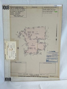
Poster - Planning Document, Shire of Diamond Valley et al, Subdivision Plan # 1018 - Parish of Nillumbik, County Bourke, Crown Allotment 4 Section 15, and Crown Allotment B Section 12, Eltham North, 1981-1982
... Subdivision Plan # 1018 - Parish of Nillumbik, County Bourke, Crown Allotment 4 Section 15, and Crown Allotment B Section 12, Eltham North....Subdivision Plan # 1018 - Parish of Nillumbik, County Bourke, Crown Allotment 4 Section 15, and Crown Allotment B Section 12, Eltham North. ...Greensborough Historical Society 34A Glenauburn Road Lower Plenty Lower Plenty melbourne Subdivision Plan # 1018 - Parish of Nillumbik, County Bourke, Crown Allotment 4 Section 15, and Crown Allotment B Section 12, Eltham North. ...Subdivision Plan # 1018 - Parish of Nillumbik, County Bourke, Crown Allotment 4 Section 15, and Crown Allotment B Section 12, Eltham North. This subdivision plan includes Ryans Road (also known as Government Road) and St Clems Street. The developer for this subdivision is Taunton Developments and the Surveyors are Fisher Cleeland Turner & Dwyer Vic, Surveyors and Engineers.An example of hard copy subdivision plans from the Greensborough area. Mainly from the Shire of Diamond Valley era (1964-1994).Plan (single sided) mounted on heavy card. Stamped and handwritten Council permissions, dates and other details. subdivision plans, shire of diamond valley, taunton developments -
 Kew Historical Society Inc
Document - Urban Planning Document, City of Kew, City of Kew : Minimum Size of Allotment Required, 1945-1955
... City of Kew : Minimum Size of Allotment Required...The by-laws specify the size of allotments in which single unit dwellings, attached houses and maisonettes, and flats could be built. ...Undated typed document, issued by the City of Kew (1921-1994) indicating the minimum size of allotment required in Barkers Road, Burke Road, Cotham Road, Glenferrie Road and Studley Park Road. ...The by-laws specify the size of allotments in which single unit dwellings, attached houses and maisonettes, and flats could be built. ...A document outlining the relevant by-laws produced by the City Of Kew to regulate the minimum size of allotments in Barkers Road, Burke Road, Cotham Road, Glenferrie Road and Studley Park Road, as well as in other streets more generally. The by-laws specify the size of allotments in which single unit dwellings, attached houses and maisonettes, and flats could be built. In the ‘main streets’ a minimum land area for single unit dwellings was 8,100 square feet, with an average frontage of 60’ and a depth of 135’. In other streets this was reduced to an overall size of 6,250 square feet, with an average dimensions of 50’ x 125’. In specifying the land area required by flats, different sizes were regulated for the construction of between two and six flats. Six flats at the time when the regulations were passed must have been the upper limit permitted. Understanding the size of land listed in imperial measurements can be a challenge. Within Australia, the so-called quarter acre block was approximately 11,000 square feet. Those specified in the by-laws would appear to be smaller. The document was pasted on the reverse of a subdivision plan in the collection.This is a rare (undated) document produced by the City of Kew defining how subdivision within the municipality should occur. The document was created to constrain unbridled speculation in subdivisions in the various parts of Kew and East Kew.Undated typed document, issued by the City of Kew (1921-1994) indicating the minimum size of allotment required in Barkers Road, Burke Road, Cotham Road, Glenferrie Road and Studley Park Road. The document is mounted on board and waterstained. It was presumably used by a real estate agent. [Formerly catalogued as MAP.0066].city of kew - by-laws and regulations, subdivisions - kew - studley park -
 Bacchus Marsh & District Historical Society
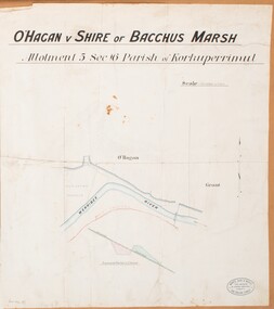
Map, O'Hagan v Shire of Bacchus Marsh, Allotment 5, Sec 16, Parish of Korkuperrimul
... O'Hagan v Shire of Bacchus Marsh, Allotment 5, Sec 16, Parish of Korkuperrimul...Features identified on the map are allotment 5, section 16, Parish of Korkuperrimul, a 'cultivation paddock', a section of the Werribee River, the path of a section of a 'Main Channel', and a barrier or filled in section across the Werribee River called 'Lee's Filling'. ...Single page map showing allotment 5, section 16 in the Parish of Korkuperrimul, Scale 4 chains to inch. ...O'Hagan v Shire of Bacchus Marsh, Allotment 5, Sec 16, Parish of Korkuperrimul Map Shire of Bacchus Marsh ...The purpose for this map being created or the date when it was made has not been established. It appears to be documentation relating to a legal dispute by a landowner named O'Hagan and the Shire of Bacchus Marsh. Features identified on the map are allotment 5, section 16, Parish of Korkuperrimul, a 'cultivation paddock', a section of the Werribee River, the path of a section of a 'Main Channel', and a barrier or filled in section across the Werribee River called 'Lee's Filling'. The O'Hagan is likely to be Patrick O'Hagan, 1829-1914 who arrived in Bacchus Marsh in 1864 and was a prominent citizen and landowner in the area for many years until his death in 1914.Single page map showing allotment 5, section 16 in the Parish of Korkuperrimul, Scale 4 chains to inch. Part of a set of maps which are pasted into a bound volume containing 76 maps or plans in total. High resolution digital image stored on BMDHS computer network. Stamped: Munzt, Bace and Muntz, Civil Engineers and Licensed Surveyors , 388 Collins Streetbacchus marsh victoria maps, water supply structures and establishments, watercourses -
 Emerald Museum & Nobelius Heritage Park
Map - Image of Surveyors Map of road classification - Beaconsfield-Emerald Rd. near Summit Ave., Emerald 1973, Crown allotment and former Govt. Road classification - Beaconsfield-Emerald Rd. near summit Ave., Emerald 1973, c1973
... Crown allotment and former Govt. Road classification - Beaconsfield-Emerald Rd. near summit Ave., Emerald 1973...Title Survey Division/Crown Description/Part of Crown Allotment and Former Government Rd., Parish of Gembrook, County of Mornington...Emerald Museum & Nobelius Heritage Park 5 Crichton Rd Emerald yarra-valley-and-the-dandenong-ranges Title Survey Division/Crown Description/Part of Crown Allotment and Former Government Rd., Parish of Gembrook, County of Mornington Image of Surveyors map indicating changes to Beaconsfield-Emerald Rd., near Summit Ave., Emerald Crown allotment and former Govt. ...Image of Surveyors map indicating changes to Beaconsfield-Emerald Rd., near Summit Ave., EmeraldTitle Survey Division/Crown Description/Part of Crown Allotment and Former Government Rd., Parish of Gembrook, County of Mornington -
 Ringwood and District Historical Society
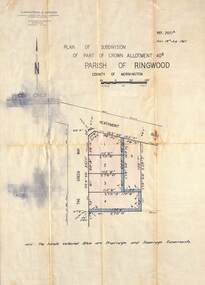
Map - Plan of Subdivision, Part of Crown Allotment 40B, Parish of Ringwood, County of Mornington - 1965
... Part of Crown Allotment 40B, Parish of Ringwood, County of Mornington - 1965...Map showing residential allotments numbered 1 to 5 on Heathmont Road and The Greenway, Heathmont, Victoria....Map showing residential allotments numbered 1 to 5 on Heathmont Road and The Greenway, Heathmont, Victoria. ...Map showing residential allotments numbered 1 to 5 on Heathmont Road and The Greenway, Heathmont, Victoria.Ref. 2937A Date 19 July 1965. Kirkpatrick & Webber, Licensed Surveyors, Civil Engineers & Town Planners, Maroondah Highway, Ringwood Telephone 870 0321. -
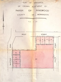 Ringwood and District Historical Society
Document, Plan of Subdivision - Part of Crown Allotment 10A, Parish of Ringwood, County of Mornington - 1957
... Plan of Subdivision - Part of Crown Allotment 10A, Parish of Ringwood, County of Mornington - 1957...Map of residential allotments in Wantirna Road and Reilly Street, Ringwood, and Philip Street, Heathmont, Vic....Map of residential allotments in Wantirna Road and Reilly Street, Ringwood, and Philip Street, Heathmont, Vic. ...Map of residential allotments in Wantirna Road and Reilly Street, Ringwood, and Philip Street, Heathmont, Vic.Footnote includes "Lots numbered 5 to 11 and 16 to 23 both inclusive are not included in this plan. Signature of Consulting Engineer - Alan J. Brown BCE, LS, MVIS, Licensed Surveyor, Dillons Buildings, 1 Riversdale Road, Camberwell (Phone) WF3528 dated 1-4-1957. -
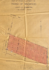
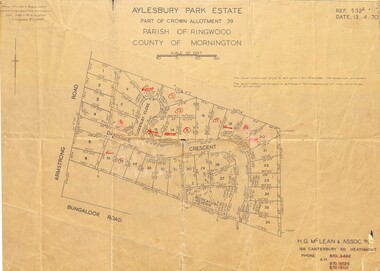 Ringwood and District Historical Society
Map - Plan of Subdivision, Aylesbury Park Estate, Part of Crown Allotment 39, Parish of Ringwood, County of Mornington - 1970
... Aylesbury Park Estate, Part of Crown Allotment 39, Parish of Ringwood, County of Mornington - 1970....Map showing residential allotments for sale in Armstrong Road, Danielle Crescent and Locksley Close, Heathmont, Victoria....Aylesbury Park Estate, Part of Crown Allotment 39, Parish of Ringwood, County of Mornington - 1970. ...Map showing residential allotments for sale in Armstrong Road, Danielle Crescent and Locksley Close, Heathmont, Victoria.Ref.532A Date 13.4.70. Paul Millar & Associates, Land & Engineering Surveyors, 14A Main Street Croydon (Phone) 723 4493. Ref.532A Date 13.4.70. (Agent) H.G. McLean & Assoc P/L, 166 Canterbury Road Heathmont, Phone 8703422 A.H. 8706726 8700112. -
 Ringwood and District Historical Society
Map - Plan of Subdivision, Part of Crown Allotment 39, Parish of Ringwood, County of Mornington - 1949
... Part of Crown Allotment 39, Parish of Ringwood, County of Mornington - 1949...Map showing residential allotments numbered 1 to 12 on Armstrong Road and Louis Street, Heathmont, Victoria....Map showing residential allotments numbered 1 to 12 on Armstrong Road and Louis Street, Heathmont, Victoria. ...Map showing residential allotments numbered 1 to 12 on Armstrong Road and Louis Street, Heathmont, Victoria.Certification signed and dated by Russell Francis Kinnane, Licensed Surveyor, 18th February, 1949. -
 Ringwood and District Historical Society
Map - Plan of Subdivision, Part of Crown Allotment 39, Parish of Ringwood, County of Mornington - 1949
... Part of Crown Allotment 39, Parish of Ringwood, County of Mornington - 1949...Map showing residential allotments numbered 1 to 18 on Armstrong Road and Harriet Street, Heathmont, Victoria....Map showing residential allotments numbered 1 to 18 on Armstrong Road and Harriet Street, Heathmont, Victoria. ...Map showing residential allotments numbered 1 to 18 on Armstrong Road and Harriet Street, Heathmont, Victoria.Certification signed and dated by Russell Francis Kinnane, Licensed Surveyor, 12th October, 1949. -
 Whitehorse Historical Society Inc.
Document, Crown Allotment
... Crown Allotment...Land documents relating to Crown Allotment 116 Shady Grove Nunawading Parish of Nunawading County of Bourke...Whitehorse Historical Society Inc. 2-10 Deep Creek Road Mitcham melbourne land titles holmes dave shady grove nunawading no.76 helen jobbins thomas the freehold investment and banking company of australia ltd wilson david duncan butchart boyle walter holbery emily rachel fisher james cowley morgan Land documents relating to Crown Allotment 116 Shady Grove Nunawading Parish of Nunawading County of Bourke Land documents relating to Crown Allotment 116 Shady Grove Nunawading Parish of Nunawading County of Bourke Crown Allotment Document Document ...Land documents relating to Crown Allotment 116 Shady Grove Nunawading Parish of Nunawading County of BourkeLand documents relating to Crown Allotment 116 Shady Grove Nunawading Parish of Nunawading County of BourkeLand documents relating to Crown Allotment 116 Shady Grove Nunawading Parish of Nunawading County of Bourkeland titles, holmes, dave, shady grove nunawading no.76, helen, jobbins, thomas, the freehold investment and banking company of australia ltd, wilson, david duncan butchart, boyle, walter, holbery, emily rachel, fisher, james cowley morgan -
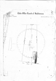
 Ringwood and District Historical Society
Map, Plan of Survey, Parish of Ringwood - Part of Crown Allotment 31A - 1950
... Plan of Survey, Parish of Ringwood - Part of Crown Allotment 31A - 1950...Hand drawn and labelled copy of map with survey measurements of allotment on Isobel Avenue (Isabel Avenue?), Ringwood East. ...Plan of Survey, Parish of Ringwood - Part of Crown Allotment 31A - 1950 Map ...Hand drawn and labelled copy of map with survey measurements of allotment on Isobel Avenue (Isabel Avenue?), Ringwood East. Raymond Dudley Steele Licensed Surveyor 10-8-50, signed 6-9-50, Seal of Borough of Ringwood 26-9-50. Rubber stamp - Dugdale, Simmons & Stevens, Solicitors, Peacock House, 486 Bourke Street Melbourne. Typewritten heading on backing paper - Capt. M.H. Moyes - Correspondence Supplementary to Statements. -
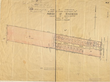 Ringwood and District Historical Society
Map, Plan of Subdivision - Part of Crown Allotment 33A, Parish of Ringwood, County of Mornington - (Undated, circa 1920s-30s)
... Plan of Subdivision - Part of Crown Allotment 33A, Parish of Ringwood, County of Mornington - (Undated, circa 1920s-30s)....Map showing layout of 24 numbered allotments in Byrne Road, off Bayswater Road, North Bayswater, Victoria....Map showing layout of 24 numbered allotments in Byrne Road, off Bayswater Road, North Bayswater, Victoria. ...Map showing layout of 24 numbered allotments in Byrne Road, off Bayswater Road, North Bayswater, Victoria.Rubber-stamped Garlick and Stewart Engineers and Surveyors, Melbourne. Handwritten price notations ranging between £65-£300. Terms 3 years on £50 deposit at 4-1/2% 6 months. K.P. Rees Solicitors acting for the vendor. -
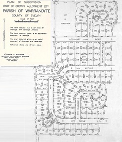 Ringwood and District Historical Society
Document - Map, Part of Crown Allotment 27C, Parish of Warrandyte, County of Evelyn, Ringwood, Victoria - c.1970
... Part of Crown Allotment 27C, Parish of Warrandyte, County of Evelyn, Ringwood, Victoria - c.1970...Photocopy of subdivision plan 75131 Vol 3439 Fol 712 showing numbered residential allotments with property dimensions....Photocopy of subdivision plan 75131 Vol 3439 Fol 712 showing numbered residential allotments with property dimensions. Part of Crown Allotment 27C, Parish of Warrandyte, County of Evelyn, Ringwood, Victoria - c.1970 Document Map ...Photocopy of subdivision plan 75131 Vol 3439 Fol 712 showing numbered residential allotments with property dimensions.Surveyors and Consulting Engineers - O'Connor & Beveridge, Main Eltham Road, Lower Plenty, Tel. 432668. Rubber-stamped "Photocopy - Titles Office Complied 17 Feb 1970". Map includes Lockhart Road, Lansell Close, Terrara Place, Goldsmith Avenue, Park Hill Drive, Hilldale Close, and Elm Court, Ringwood, Victoria. -
 Ringwood and District Historical Society
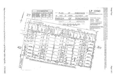
Document, Property Research Notes - Reaghill, Ringwood East, Victoria. Appendix 10 - Plan of Subdivision, Part of Crown Allotment 43, Parish of Ringwood, County of Mornington, circa 1931
... Appendix 10 - Plan of Subdivision, Part of Crown Allotment 43, Parish of Ringwood, County of Mornington, circa 1931....Photocopy of A4 Landata printout showing numbered allotments and property dimensions. Includes undated list of easement modifications....Photocopy of A4 Landata printout showing numbered allotments and property dimensions. Includes undated list of easement modifications. ...Photocopy of A4 Landata printout showing numbered allotments and property dimensions. Includes undated list of easement modifications.LP13543. Subdivision includes Alexander Road, Wood Street, Scenic Avenue, Vista Avenue and Grand View Avenue, Ringwood East. -
 Ringwood and District Historical Society
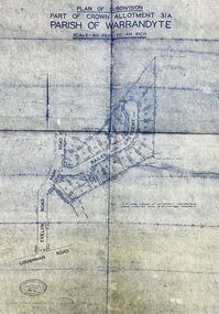
Map - Plan of Subdivision, Part of Crown Allotment 31A, Parish of Warrandyte - (Undated)
... Part of Crown Allotment 31A, Parish of Warrandyte - (Undated)...Attached photocopy of undated map of allotment on south-east corner of Evelyn and Park Roads....Part of Crown Allotment 31A, Parish of Warrandyte - (Undated) Map Plan of Subdivision ...Facsimile blueprint copy of 24 residential allotments with property dimensions in Bailey Crescent (later Gabriella Court) and McEwan Street (later Suzanne Court) off Park Road and Evelyn Road, Ringwood North. Attached photocopy of undated map of allotment on south-east corner of Evelyn and Park Roads.Rubber stamp impression - J. Horne, Licensed Surveyor, 458 Nepean Highway, Frankston 31736. -
 Ringwood and District Historical Society
Map, Subdivision Plan - Crown Allotment 20 Section E, Parish of Ringwood, Township of Ringwood, County of Mornington. (Undated, circa 1920s)
... Subdivision Plan - Crown Allotment 20 Section E, Parish of Ringwood, Township of Ringwood, County of Mornington. ...Wax/parchment paper printout of numbered subdivision allotments and store, corner of Mount Dandenong Road and Braeside Avenue, Ringwood....Subdivision Plan - Crown Allotment 20 Section E, Parish of Ringwood, Township of Ringwood, County of Mornington. ...Wax/parchment paper printout of numbered subdivision allotments and store, corner of Mount Dandenong Road and Braeside Avenue, Ringwood.Rubber-stamped with circa 1920s stamp of W.J. Bonwick, Licensed Surveyor, 19 Clarence Street, East Malvern, Telephone U4833. -
 Emerald Museum & Nobelius Heritage Park
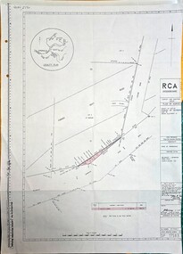
Map - Plan of Survey County of Evelyn Crown Allotment 51, Belgrave - Gembrook Rd. Acquire & declare, Near Lawson Rd, Acquire & declare Crown Allotment 51, Belgrave - Gembrook Rd, c1988
... Acquire & declare Crown Allotment 51, Belgrave - Gembrook Rd. ...Image of Plan of Survey County of Evelyn Crown Allotment 51, Belgrave - Gembrook Rd. Acquire & declare, Near Lawson Rd....Acquire & declare Crown Allotment 51, Belgrave - Gembrook Rd. Map Plan of Survey County of Evelyn Crown Allotment 51, Belgrave - Gembrook Rd. ...Image of Plan of Survey County of Evelyn Crown Allotment 51, Belgrave - Gembrook Rd. Acquire & declare, Near Lawson Rd.RCA/Survey and Mapping/Plan of Survey/ County of Evelyn, Parish of Gembrook, Part of Crown Alloment 51/A.M.G. reference 792/55/364200/5801000/Municipality - Shire of Sherbrooke/Proposed Action Belgrave - Gembrook Road - Acquire & Declare/Plan prepared and signed by John E. Tulloch, 60 Denmark Street, Kew/10th March 1988/Approved Manager of Survey & Mapping - JD Murray 2-6-88/File number 87/17936/1/Survey Register Number 622/SP 17583 -
 Ringwood and District Historical Society
Map - Plan of Subdivision, Part of Crown Allotment 27B Parish of Warrandyte County of Bourke (undated, circa 1970)
... Part of Crown Allotment 27B Parish of Warrandyte County of Bourke (undated, circa 1970)...Photocopied subdivision map of 38 residential allotments in Glenvale Road, Cantala Crescent, and Giana Court, north of Kubba Road, Ringwood....Part of Crown Allotment 27B Parish of Warrandyte County of Bourke (undated, circa 1970) Map Plan of Subdivision ...Photocopied subdivision map of 38 residential allotments in Glenvale Road, Cantala Crescent, and Giana Court, north of Kubba Road, Ringwood. -
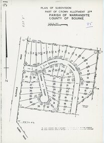
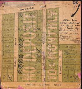 Ringwood and District Historical Society
Map, Residential Subdivision Allotment Layout on Mullum Mullum Road, Hobart Street, Paxton Street, Arnold Street and Warrandyte Road, Ringwood, Vic. (Undated, circa 1920)
... Residential Subdivision Allotment Layout on Mullum Mullum Road, Hobart Street, Paxton Street, Arnold Street and Warrandyte Road, Ringwood, Vic. ...Map on cardboard backing clipped from Subdivision Plan 7578 - Part of Crown Allotment 32, Parish of Warrandyte, County of Evelyn....Map on cardboard backing clipped from Subdivision Plan 7578 - Part of Crown Allotment 32, Parish of Warrandyte, County of Evelyn. ...Map on cardboard backing clipped from Subdivision Plan 7578 - Part of Crown Allotment 32, Parish of Warrandyte, County of Evelyn.H.C. Crouch, Licensed Surveyor, 443 Lt Collins Street, Melbourne. Includes handwritten real estate sales notations and Certificate of Title reference - Vol 3922 Fol 784242. -
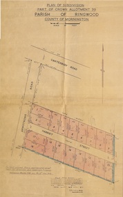
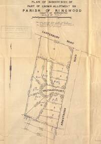 Ringwood and District Historical Society
Map - Plan of Subdivision, Part of Crown Allotment 39, Parish of Ringwood, County of Mornington - (Undated, circa 1950)
... Part of Crown Allotment 39, Parish of Ringwood, County of Mornington - (Undated, circa 1950)....Map showing residential allotments numbered 1 to 13 on Valdale Court and Armstrong Road off Canterbury Road, Heathmont, Victoria....Part of Crown Allotment 39, Parish of Ringwood, County of Mornington - (Undated, circa 1950). ...Map showing residential allotments numbered 1 to 13 on Valdale Court and Armstrong Road off Canterbury Road, Heathmont, Victoria. Richard Rogalsky, Land Surveyor and Town Planner, 25 Napier Street, Essendon (at Essendon Junction) 37-2642 - 37-6570. -
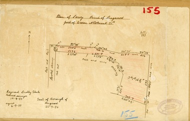
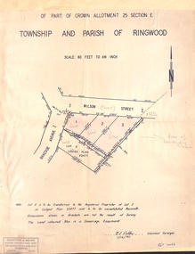 Ringwood and District Historical Society
Document - Plan of Subdivision, Part of Crown Allotment 25 Section E, Township and Parish of Ringwood - 1961
... Part of Crown Allotment 25 Section E, Township and Parish of Ringwood - 1961...Map showing residential allotments numbered 1, 2, 3 and 4, on Wilson Street and Braeside Avenue, Ringwood East, Victoria....Part of Crown Allotment 25 Section E, Township and Parish of Ringwood - 1961 Document Plan of Subdivision ...Map showing residential allotments numbered 1, 2, 3 and 4, on Wilson Street and Braeside Avenue, Ringwood East, Victoria.Signed and dated 1/12/1961. Rubber stamped Kirkpatrick & Webber, Licensed Surveyors, Civil Engineers & Town Planners, 225 Maroondah Highway, Ringwood, Telephone 870-0321. Ref 3438C. "Note: Lot 4 is to be transferred to the Registered Proprietor of Lot 2 on Lodged Plan 23477 and is to be consolidated therewith." Map also includes handwritten Estate Agent notations.