Showing 133 items matching "alluvial gold"
-
 Tarnagulla History Archive
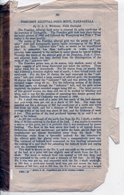
Pages from a book: Poseidon Alluvial Gold Mine, Tarnagulla, Poseidon Alluvial Gold Mine, Tarnagulla, circa 1916
... Pages from a book: Poseidon Alluvial Gold Mine, Tarnagulla...Poseidon Alluvial Gold Mine, Tarnagulla...Pages from a book (unknown), this excerpt titled 'Poseidon Alluvial Gold Mine, Tarnagulla' by O.A.L. Whitelaw, Field Geologist. ...Poseidon Alluvial Gold Mine, Tarnagulla Pages from a book: Poseidon Alluvial Gold Mine, Tarnagulla ...Murray Comrie Collection. Pages from a book (unknown), this excerpt titled 'Poseidon Alluvial Gold Mine, Tarnagulla' by O.A.L. Whitelaw, Field Geologist. Includes a map (also extracted from the book) with title 'Poseidon Alluvial Gold Mines'. Map of the mines entire workings, above and below ground. tarnagulla, poseidon, mine, mining, gold -
 Eltham District Historical Society Inc
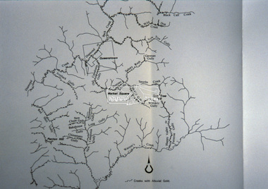
Slide - Photograph, Creeks with Alluvial gold, St Andrews, c.Sep. 1989
... Creeks with Alluvial gold, St Andrews......Alluvial gold...The presentation included slides of historic photos from the Shire of Eltham Pioneers collections as well as several recent views. Map Creeks Alluvial gold St Andrews Process Date Sep 1989 35mm colour positive transparency (1 of 33) Mount - Agfa CS System grey 8 dots Creeks with Alluvial gold, St Andrews Slide Photograph ...Part of a slide show presentation "Bridges & Waterways of the Shire" by Russell Yeoman to the 13 September 1989 Society meeting. The presentation included slides of historic photos from the Shire of Eltham Pioneers collections as well as several recent views.35mm colour positive transparency (1 of 33) Mount - Agfa CS System grey 8 dotsProcess Date Sep 1989map, creeks, alluvial gold, st andrews -
 Bendigo Historical Society Inc.
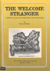
Book - BOOK: THE WELCOME STRANGER - A DEFINITIVE ACCOUNT OF THE WORLDS LARGEST ALLUVIAL GOLD NUGGET, 1999
... BOOK: THE WELCOME STRANGER - A DEFINITIVE ACCOUNT OF THE WORLDS LARGEST ALLUVIAL GOLD NUGGET...This alluvial gold nugget was discovered in 1869 at Moliagul, by Cornish miners, John Deason and Richard Oates. ...Book BOOK: THE WELCOME STRANGER - A DEFINITIVE ACCOUNT OF THE WORLDS LARGEST ALLUVIAL GOLD NUGGET ...This alluvial gold nugget was discovered in 1869 at Moliagul, by Cornish miners, John Deason and Richard Oates. It's gross weight was 109.51 kg and net weight of gold was 72.02 kg. It was melted down and the ingots sent to the Bank of England.Softcover book with gold coloured cover with a sketch of the Welcome Stranger nugget on the front and a blurb on the back. Contains 50 pages covering the history, myths, geology, details of the discoverers and the discovery of the nuggett. Contains black and white photographs and sketches.Terry F Pottergold -
 The Beechworth Burke Museum
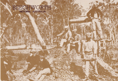
Postcard, George Symons, c.1990
... ...alluvial gold...During this period, in the 1870s, the surface alluvial gold had been discovered and removed from location. ...In order to reach less / accessible alluvial gold diggers began sinking shafts as much as twenty to thirty feet down / and the mines required timbering and winches / to bring the paydirt to the top. / This syndicate has been unable to afford the / luxury of a horse (about 50 pounds) and so everything / must go up and down by windlass and rawhide / bucket. / Photo: Mitchell Library, Sydney / A sepia tone facsimile of / an early Australian photograph...During this period, in the 1870s, the surface alluvial gold had been discovered and removed from location. ...The photograph printed on this postcard comes from the collection of the Mitchell Library in Sydney. It is sepia in tone and depicts seven men standing and sitting around a mine shaft in the Beechworth region. The photograph has been dated to approximately 1872. This period in history post-dates the Victorian gold rushes which occurred 1852-1853 in Ballarat, Bendigo and Beechworth. During this period, in the 1870s, the surface alluvial gold had been discovered and removed from location. Therefore, in order to reach the deeper and less accessible alluvial gold, diggers began to dig shafts into the earth. These shafts sunk below the ground level by 20 to 30 feet and required timber structures around the entrance and winches to bring the paydirt to the top. The top of this wooden structure is visible behind the man standing in the upper right of the image. This type of mining was highly dangerous as mines often caved in which injured the minors and often resulted in death. Thus, following this period, in the early 1900s, miners opted instead for hydrolic slucing which cut away the earth without the devastating consequences of a mine cave in. This particular group of miners appear to have been unable to afford a horse (then worth around 50 pounds) which were generally used at mines like this to help pull buckets attached to ropes up and down the mine. Instead, this group brought the buckets up and down by windlass. The windlass was a wooden structure mounted over the mining shaft and fitted with a hand-cranked winch which enabled the bucket attached to the rope to be brought up and down.Gold was first discovered in Beechworth in Spring and Reid's Creek in the summer of 1852-1853. At its popularity, this region had approximately 8000 people on the gold fields searching for gold on the banks of these creeks. These periods did not require the use of heavy machinery or the digging of deep mining shafts like the one depicted in this image. Therefore, this image has important connotations for the technologies associated with mining during the approximated 1870s when gold was harder to access. This is a later period in gold history which does not fit into the "gold rush" period. Instead, it occurred after the surface gold had disappeared and therefore, is essential for researchers who are investigating the mining techniques and structures used to reach the alluvial gold which was located deeper under ground in the 1870s. This period predates the use of big heavy machinery used to mine in the 1900s which include dredges. Images such as this one can also impart essential information as to the wardrobe and fashion of men during this period. It also imparts knowledge about the landscape of Beechworth which is useful for people researching the environment and impact of gold mining in the north-east region of Victoria. In addition, since this image is a postcard reproduction of an early Australian image which may date to approximately 1990 it can impart knowledge as to the interests of people during this time period when there may have been an increase into Australian history.A sepia tone facsimile of an early Australian photograph (circa 1872) printed as a postcard.Obverse: BEECHWORTH / Victoria, Australia / Reverse: GM 2 3275 / CORRESPONDENCE / AUSTRALIAN / YESTERYEAR / CARDS / ADDRESS / Published by George Symons (057) 65 3240 / THE MINEHEAD C. 1872 / The easily gleaned gold of the early fields did / not last very long. In order to reach less / accessible alluvial gold diggers began sinking shafts as much as twenty to thirty feet down / and the mines required timbering and winches / to bring the paydirt to the top. / This syndicate has been unable to afford the / luxury of a horse (about 50 pounds) and so everything / must go up and down by windlass and rawhide / bucket. / Photo: Mitchell Library, Sydney / A sepia tone facsimile of / an early Australian photographmining album, gold mine, beechworth, burke museum, mine shaft, postcard, australian yesteryear cards, george symons, the minehead, gold fields, alluvial gold, early australia, c.1872, 1872, gold diggers, north east victoria -
 Clunes Museum
Photograph, C. NETTLETON, APPROX. 1865
... .1 SEPIA PHOTOGRAPH OF CLUNES ALLUVIAL GOLD MINING CO. .2 SEPIA PHOTOGRAPH OF POPPET HEAD-MINERS ON PLATFORM-THATCHED ROOF BUILDINGS, SCATTERING OF LARGE LOGS IN FOREGROUND, USED FOR FIRES. .3 COPY OF ABOVE PHOTOGRAPH IN BLACK AND WHITE (POSTCARD SIZE)....1 PRINTED: CLUNES ALLUVIAL GOLD MINING COMPANY REGISTERED CLUNES .2 PRINTED ON FRONT : ALLUVIAL GOLD MINING COMPANY REGISTERED CLUNES HANDWRITTEN: PERIOD 1865. ...RED CLAY FROM THIS MINE WAS USED FOR BRICK MAKING. photographs mining CLUNES ALLUVIAL MINING COMPANY .1 PRINTED: CLUNES ALLUVIAL GOLD MINING COMPANY REGISTERED CLUNES .2 PRINTED ON FRONT : ALLUVIAL GOLD MINING COMPANY REGISTERED CLUNES HANDWRITTEN: PERIOD 1865. ...THIS MINE WAS SITUATED ABOUT 100 YARDS SOUTH WEST OF ALBERT STREET AND ANGUS STREET CORNER. RED CLAY FROM THIS MINE WAS USED FOR BRICK MAKING..1 SEPIA PHOTOGRAPH OF CLUNES ALLUVIAL GOLD MINING CO. .2 SEPIA PHOTOGRAPH OF POPPET HEAD-MINERS ON PLATFORM-THATCHED ROOF BUILDINGS, SCATTERING OF LARGE LOGS IN FOREGROUND, USED FOR FIRES. .3 COPY OF ABOVE PHOTOGRAPH IN BLACK AND WHITE (POSTCARD SIZE).1 PRINTED: CLUNES ALLUVIAL GOLD MINING COMPANY REGISTERED CLUNES .2 PRINTED ON FRONT : ALLUVIAL GOLD MINING COMPANY REGISTERED CLUNES HANDWRITTEN: PERIOD 1865. SITUATED ABOUT 100 YDS SW OF ALBERT AND ANGUS STREET CORNER. RED CLAY FROM THIS MINE WAS USED FOR BRICK MAKINGphotographs, mining, clunes alluvial mining company -
 Clunes Museum
Document - MINING CERTIFICATE, 1889
... ...CLUNES ALLUVIAL GOLD MINING SYNDICATE...ORIGINAL SHARE HOLDERS CERTIFICATES FOR CLUNES ALLUVIAL GOLD MINING SYNDICATE TO BE REGISTERED AS A NO LIABILITY COMPANY IN FIFTY PROPRIETARY SHARES TO LACHLAN McLENNAN CLUNES. 31/7 1889 .1 No 47 , STAMPED BY JOHN LANGDON, STOCK BROKER, MELBOURNE .2 No 48, STAMPED BY JOHN LANGDON, STOCK BROKER, MELBOURNE...Clunes Museum 36 Fraser Street enter building through Collins Place Clunes goldfields local history document mining mining 1889 SHARE CERTIFICATE MCLENNAN LANGDON CLUNES ALLUVIAL GOLD MINING SYNDICATE ORIGINAL SHARE HOLDERS CERTIFICATES FOR CLUNES ALLUVIAL GOLD MINING SYNDICATE TO BE REGISTERED AS A NO LIABILITY COMPANY IN FIFTY PROPRIETARY SHARES TO LACHLAN McLENNAN CLUNES. 31/7 1889 .1 No 47 , STAMPED BY JOHN LANGDON, STOCK BROKER, MELBOURNE .2 No 48, STAMPED BY JOHN LANGDON, STOCK BROKER, MELBOURNE Document MINING CERTIFICATE ...ORIGINAL SHARE HOLDERS CERTIFICATES FOR CLUNES ALLUVIAL GOLD MINING SYNDICATE TO BE REGISTERED AS A NO LIABILITY COMPANY IN FIFTY PROPRIETARY SHARES TO LACHLAN McLENNAN CLUNES. 31/7 1889 .1 No 47 , STAMPED BY JOHN LANGDON, STOCK BROKER, MELBOURNE .2 No 48, STAMPED BY JOHN LANGDON, STOCK BROKER, MELBOURNElocal history, document mining, mining, 1889, share certificate, mclennan, langdon, clunes alluvial gold mining syndicate -
 Bendigo Historical Society Inc.
Document - ''REVIEW OF BENDIGO HISTORY'' (BHS)
... ... Alluvial Gold Mining. S. T. Gill...Sections headed: Earlier Days; Discovery of Gold; Influx of Diggers; Water and Mining; Transport and Development; Building and the City; A Place of Commerce; Heritage of the Past; Further information - references; Appendix 1 - Alluvial Gold Mining in Bendigo; appendix 2 - Architectural and Heritage Features; Appendix 3 - Historical Time Line Summary (1836 - 2003). ...History House 11 Mackenzie Street Bendigo goldfields BENDIGO History bendigo historical society Water Mining Architectural Influx of diggers Alluvial Gold Mining. S. T. Gill Bendigo Historical Society ''Review of Bendigo History'' 8 pages, with three appendices. ...''Review of Bendigo History'' 8 pages, with three appendices. (Published by the BHS and based on the more detailed 60-page 'Historic Guide to Bendigo'). Sections headed: Earlier Days; Discovery of Gold; Influx of Diggers; Water and Mining; Transport and Development; Building and the City; A Place of Commerce; Heritage of the Past; Further information - references; Appendix 1 - Alluvial Gold Mining in Bendigo; appendix 2 - Architectural and Heritage Features; Appendix 3 - Historical Time Line Summary (1836 - 2003). Limited number of illustrations. Attached is correspondence with Data Metallogenica re the use of this Review (date 2009). Also included are 3 pages of and email, and 2 pages of advertising Data Metallogenical.Bendigo Historical Societybendigo, history, bendigo historical society, water, mining, architectural, influx of diggers, alluvial gold mining. s. t. gill -
Whitehorse Historical Society Inc.
Article, Gold discovery at Mount Waverley, 1967
... Holland, sunk a shaft and the ground for miles was pegged out and prospectors were busy in the gullies searching for alluvial gold....Holland, sunk a shaft and the ground for miles was pegged out and prospectors were busy in the gullies searching for alluvial gold....Holland, sunk a shaft and the ground for miles was pegged out and prospectors were busy in the gullies searching for alluvial gold. Gold discovery at Mount Waverley Article Article ...Article - In 1896 gold was discovered at Mount Waverley near the corner of Springvale Road and High Street Road.Article - In 1896 gold was discovered at Mount Waverley near the corner of Springvale Road and High Street Road. The discoverer, Mr P. Holland, sunk a shaft and the ground for miles was pegged out and prospectors were busy in the gullies searching for alluvial gold.Article - In 1896 gold was discovered at Mount Waverley near the corner of Springvale Road and High Street Road. mines and mining, high street road, glen waverley, springvale road, goldmining -
 Rutherglen Historical Society
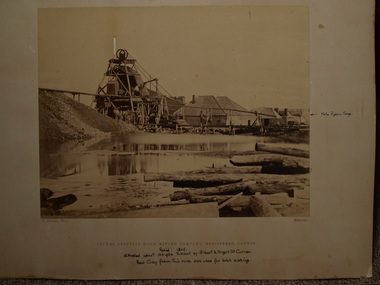
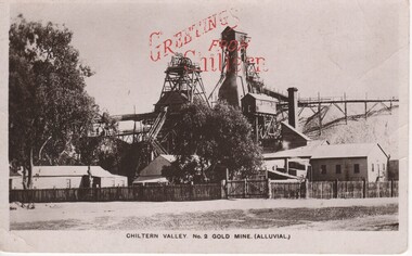
Image, F W Force, Chiltern Valley. No. 2 Gold Mine. (Alluvial.), c1900
... Chiltern Valley. No. 2 Gold Mine. (Alluvial.)...Chiltern Valley. No. 2 Gold Mine. (Alluvial.) Image F W Force ...Black and white postcard photograph of the upper structures of a gold mine and surrounding buildings.Printed in red at top of photo: "Greetings From Chiltern" Written on back of card: "c/o Mrs A. Smith. Melbourne Rd. Chiltern | Just a line to let you know I arrived safely and am having a good time. I went to a picnic on Easter Monday and had a great time. Did you go to the sports were they a success. We have plenty of music here Aggie plays the piano and I brought my violin up and a boy staying here from Melbourne sings. Hoping to hear from you soon. Your loving friend etc."chiltern, gold mining, mining industry, chiltern mine -
 Stawell Historical Society Inc
Memorabilia - Realia
... Wooden Miners Gold Cradle used for panning Alluvial Gold...Stawell Historical Society Inc 46 Longfield St Stawell grampians Stawell Wooden Miners Gold Cradle used for panning Alluvial Gold Memorabilia Realia ...Wooden Miners Gold Cradle used for panning Alluvial Goldstawell -
Federation University Historical Collection
Book, Mining Heritage Places Assessment Manual, 2000, 2000
... ...alluvial gold...Barker Library (top floor) Mount Helen goldfields mining heritage assessments heritage register coal copper alluvial gold reef gold mining terminology mount shamrock glossary of terms Brwon soft covered book of 187 pages. ...Brwon soft covered book of 187 pages. mining, heritage assessments, heritage register, coal, copper, alluvial gold, reef gold, mining terminology, mount shamrock, glossary of terms -
Clunes Museum
Memorabilia - SPECIMEN, UNKNOWN
... ...ALLUVIAL...GOLD...Clunes Museum 36 Fraser Street enter building through Collins Place Clunes goldfields MINING ALLUVIAL GOLD NIL SAMPLE OF GOLD SPECIMEN IN GREEN SMALL WOODEN AND GLASS CONTAINER Memorabilia SPECIMEN ...SAMPLE OF GOLD SPECIMEN IN GREEN SMALL WOODEN AND GLASS CONTAINERNILmining, alluvial, gold -
 Ringwood and District Historical Society
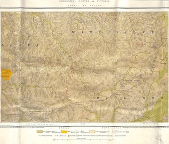
Map, Geological Survey of Victoria - County of Evelyn, Published June 1893
... Markings include soil and rock types, alluvial gold workings, quartz reefs....Markings include soil and rock types, alluvial gold workings, quartz reefs. Geological Survey of Victoria - County of Evelyn, Published June 1893 Map ...Markings include soil and rock types, alluvial gold workings, quartz reefs.Published under the direction of A.W. Howitt F.G.S. Secretary for Mines. The Hon J.H. McColl, Minister of Mines, June 1893. Surveyed by R.A. Moon, Field Geologist, under the supervision of R.A.F. Murray, Govt Geologist. Lithographed by J. M. Coakley. -
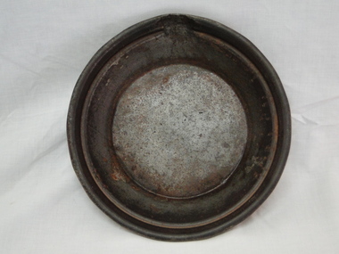
 Ballarat Heritage Services
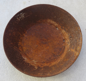
Photograph, Clare Gervasoni, Metal Gold Pan, 2017
... A gold pan was used to wash alluvial gold from gravel and dirt....Ballarat Heritage Services PO Box 2209 Bakery Hill Post Office goldfields A gold pan was used to wash alluvial gold from gravel and dirt. gold pan mining gold mining tools tools Colour photographs of a large gold pan. ...A gold pan was used to wash alluvial gold from gravel and dirt.Colour photographs of a large gold pan.gold pan, mining, gold mining tools tools -
 Federation University Historical Collection
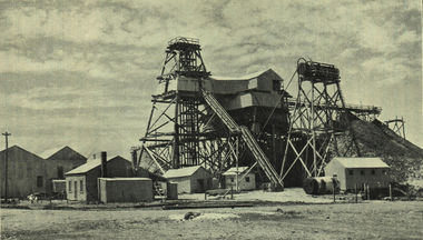
Photograph - Photograph - black and white, Talbot Alluvial Mine: working a deep lead
... ...alluvial mine...gold...Barker Library (top floor) Mount Helen goldfields Photograph included in book "Victoria: Gold and Minerals" issued by Mines Department Victoria, 1935 victoria prospecting method talbot alluvial mine gold mining mining poppet head Photograph Talbot Alluvial Mine: working a deep lead Photograph Photograph - black and white ...Photograph included in book "Victoria: Gold and Minerals" issued by Mines Department Victoria, 1935Photographvictoria, prospecting method, talbot, alluvial mine, gold mining, mining, poppet head -
 Bendigo Historical Society Inc.
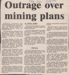
Newspaper - Kangaroo Flat Gold Mine Collection: mine exploration
... Gold...alluvial sands...Content of article includes: Ranger Gold proposal to mine alluvial sands in a streamside reserve along the Bendigo Creek; Huntly residents meet to oppose mining proposal and Bendigo and District Environmental Council were concerned about the negative effects of mining....Gold mining Bendigo Ranger Gold alluvial sands Huntly Paul Duke Jennifer Rank Bendigo Creek arsenic methyl mercury SHelley Cohn Bendigo Advertiser article, 6th April,1995, titled 'Outrage over mining plans'. ...Bendigo Advertiser article, 6th April,1995, titled 'Outrage over mining plans'. Content of article includes: Ranger Gold proposal to mine alluvial sands in a streamside reserve along the Bendigo Creek; Huntly residents meet to oppose mining proposal and Bendigo and District Environmental Council were concerned about the negative effects of mining.gold mining, bendigo, ranger gold, alluvial sands, huntly, paul duke, jennifer rank, bendigo creek, arsenic, methyl mercury, shelley cohn -
 Bright & District Historical Society operating the Bright Museum
Pan gold
... Gold pans were widely used in alluvial gold fields for seperating particles or flakes of gold from gravel, sand and the like. ...Gold pans had widespread use in alluvial gold fields where water is available. gold gold pan goldfields Gold Pan, small. ...Gold pans were widely used in alluvial gold fields for seperating particles or flakes of gold from gravel, sand and the like. This one is small and may have been used for demonstration only or for display purposes.Gold pans had widespread use in alluvial gold fields where water is available.Gold Pan, small. Diameter 240mm.gold, gold pan, goldfields -
 Halls Gap & Grampians Historical Society
Photograph - B/W, C 1887
... D'Alton's searching for alluvial gold. Photo shows Alfred and Charles D'Alton at Stony Creek Diggings. ...Halls Gap & Grampians Historical Society Centennial Hall 117-119 Grampians Road Halls Gap grampians D'Alton's searching for alluvial gold. Photo shows Alfred and Charles D'Alton at Stony Creek Diggings. ...D'Alton's searching for alluvial gold. Photo shows Alfred and Charles D'Alton at Stony Creek Diggings. Charles is on the right and Alfred is on the left. Records 126 and 127 are enlargements from this photo showing each man separately.Photo shows two men working near a sluice. One man is shovelling into a sluice, on a creek and the other is holding an implement. A gold pan rests against a tree.people, d'alton, mining, stoney creek -
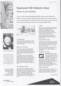 Bendigo Historical Society Inc.
Document - DIAMOND HILL HISTORIC AREA PARKS VICTORIA
... On second page is a map of the area showing historic features: Deborah Consolidated Gold workings Red, White and Blue Extended gold workings Goldfields Extended gold workings Dead Dog Gully, alluvial gold workings Glasgow & Golconda Gold workings and tramway Surface gold mining site Hansel Mundy gold workings Bendigo Goldfields Pty gold workings Stafford gold workings Langdon gold workings Great Opossum Gully alluvial gold workings...On second page is a map of the area showing historic features: Deborah Consolidated Gold workings Red, White and Blue Extended gold workings Goldfields Extended gold workings Dead Dog Gully, alluvial gold workings Glasgow & Golconda Gold workings and tramway Surface gold mining site Hansel Mundy gold workings Bendigo Goldfields Pty gold workings Stafford gold workings Langdon gold workings Great Opossum Gully alluvial gold workings Document DIAMOND HILL HISTORIC AREA PARKS VICTORIA ...Document, two pages, prepared by Parks Victoria in relation to the Diamond Hill Historic Area. Contains information regarding the history of the area; German Miners; Plants and animals. On second page is a map of the area showing historic features: Deborah Consolidated Gold workings Red, White and Blue Extended gold workings Goldfields Extended gold workings Dead Dog Gully, alluvial gold workings Glasgow & Golconda Gold workings and tramway Surface gold mining site Hansel Mundy gold workings Bendigo Goldfields Pty gold workings Stafford gold workings Langdon gold workings Great Opossum Gully alluvial gold workingsbendigo, mining, diamond hill -
 Bendigo Historical Society Inc.
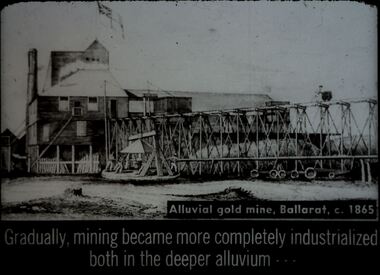
Slide - DIGGERS & MINING. DIGGERS AND MINERS, c1865
... Diggers and miners. Alluvial gold mine, Ballarat, c. 1865. Gradually, mining became more completely industrialized both in the deeper alluvium - - - Slide shows the building at the mine, with the raised rails to take the rock raised from in the mine to be crushed to allow the gold to be extracted. ...Diggers and miners. Alluvial gold mine, Ballarat, c. 1865. Gradually, mining became more completely industrialized both in the deeper alluvium - - - Slide shows the building at the mine, with the raised rails to take the rock raised from in the mine to be crushed to allow the gold to be extracted. ...Diggers & Mining. Diggers and miners. Alluvial gold mine, Ballarat, c. 1865. Gradually, mining became more completely industrialized both in the deeper alluvium - - - Slide shows the building at the mine, with the raised rails to take the rock raised from in the mine to be crushed to allow the gold to be extracted. The mine's flag is flying. Markings: 28 994:LIF I. Used as a teaching aid.hanimounteducation, tertiary, goldfields -
Clunes Museum
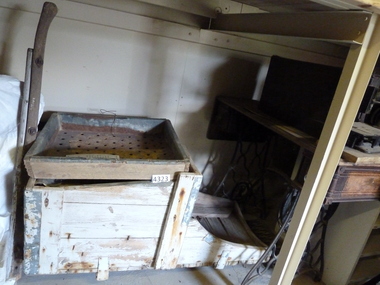
Tool - GOLD CRADLE & PANNING DISH, JAMES ESMOND, CIRCA 1850
... USED TO OBTAIN ALLUVIAL GOLD THE DESIGN OF THIS EQUIPMENT IS MOSTLY BASED ON THE PRINCIPLE OF THE WAY HEAVY MINERALS ARE CONCENTRATED IN ALLUVIAL DEPOSITS. ...Clunes Museum 36 Fraser Street enter building through Collins Place Clunes goldfields USED TO OBTAIN ALLUVIAL GOLD THE DESIGN OF THIS EQUIPMENT IS MOSTLY BASED ON THE PRINCIPLE OF THE WAY HEAVY MINERALS ARE CONCENTRATED IN ALLUVIAL DEPOSITS. ...USED TO OBTAIN ALLUVIAL GOLD THE DESIGN OF THIS EQUIPMENT IS MOSTLY BASED ON THE PRINCIPLE OF THE WAY HEAVY MINERALS ARE CONCENTRATED IN ALLUVIAL DEPOSITS. THE PROSPECTING DISH IS USED WHEN WORKING WITH SMALL AMOUNTS OF STONES & CLAY WHILE BIGGER JOBS THE CRADLE OR BANJO IS MORE EFFICIENT. THE GAUZE OF MESH IN THE SIEVE IS VARIABLE. THE CRADLE OR BANJO IS USUALLY SET UP AT RIGHT ANGLES TO A SHALLOW CREEK OR WATERHOLE WITH THE OPEN ENDS TOWARDS THE WATER.1 WOODEN CONSTRUCTION MADE BY HAND WITH GAUZE FILTER IN UPPER SECTION TO SEPARATE QUARTZ ROCKS, SAND AND SOIL. A HANDLE ON BOX LIKE CONSTRUCTION IS USED TO ROCK THE CRADLE WHICH IS MOUNTED WITH ITS ROCKERS RESTING ON WOODEN BEARERS. .2 PANlocal history, mining equipment, mining -
 Ballarat Heritage Services
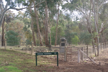
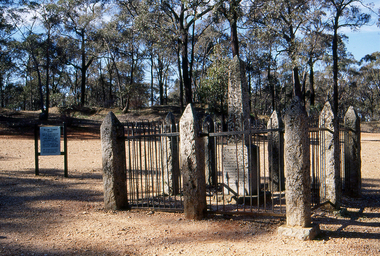
Photograph - Colour, Vaughan Chinese Cemetery, 2017, 16/07/2017
... Established during the great Mount Alexander alluvial gold rush of 1852-54 the cemetery is located on a small hill overlooking one of the richest spots on the goldfield (the junction of Fryers Creek and Loddon River). ...Ballarat Heritage Services PO Box 2209 Bakery Hill Post Office goldfields Established during the great Mount Alexander alluvial gold rush of 1852-54 the cemetery is located on a small hill overlooking one of the richest spots on the goldfield (the junction of Fryers Creek and Loddon River). ...Established during the great Mount Alexander alluvial gold rush of 1852-54 the cemetery is located on a small hill overlooking one of the richest spots on the goldfield (the junction of Fryers Creek and Loddon River). The location of the cemetery was chosen because it was a convenient piece of ground where gold was not likely to be discovered, and burials were mainly of Chinese miners. It remained in use until 1857. The cemetery was restored in 1929 using money raised within the Chinese communities of Bendigo and Castlemaine. Colour photograph of the Chinese Cemetery at Vaughan. vaughan, vaughan springs, vaughan chinese cemetery, chinese -
 Bendigo Historical Society Inc.
Document - MINING IN BENDIGO COLLECTION: MINING ARTICLE FROM THE SCHOOL PAPER
... Mentioned in the article are the licence tax, which preceded the Miners Right, the building of slab huts, a nugget of gold weighing 340 ounces and christened The Victoria which was later presented to Queen Victoria, how alluvial gold came into being, notes about the Needle Mine's square shaped chimney with the smoke holes in its tapering top and the progress which has occurred in Bendigo both cultural and in the buildings....Mentioned in the article are the licence tax, which preceded the Miners Right, the building of slab huts, a nugget of gold weighing 340 ounces and christened The Victoria which was later presented to Queen Victoria, how alluvial gold came into being, notes about the Needle Mine's square shaped chimney with the smoke holes in its tapering top and the progress which has occurred in Bendigo both cultural and in the buildings. ...Printed article from The School Paper dated July 1, 1952. The article was written for The School Paper by Lucy Hill. Mentioned in the article are the licence tax, which preceded the Miners Right, the building of slab huts, a nugget of gold weighing 340 ounces and christened The Victoria which was later presented to Queen Victoria, how alluvial gold came into being, notes about the Needle Mine's square shaped chimney with the smoke holes in its tapering top and the progress which has occurred in Bendigo both cultural and in the buildings.document, gold, mining in bendigo, mining in bendigo, mining article from the school paper, lucy hill, miners right, queen victoria, marco polo sailing ship, bendigo goldfield, the needle mine, loddon regional, bendigo advertiser, easter fair, chinese dragon, teachers' training college, competitions society, shakespeare society, agricultural society and show -
 Federation University Historical Collection
Slide, Welcome Stranger Monument, c1970
... With the help of Oates, he uncovered the largest recorded alluvial gold nugget – known as the Welcome Stranger. ...With the help of Oates, he uncovered the largest recorded alluvial gold nugget – known as the Welcome Stranger. ...The first recorded discovery of gold in Moliagul was in September 1852 and, before long, the area was flooded with over 4,000 miners. Two of those miners, John Deason and Richard Oates, had arrived in Bendigo in 1954 seeking their fortune. After eight years of little success, the friends moved to Moliagul and pegged a puddling claim. On 05 February 1869, Deason discovered a nugget near the roots of a tree, just 3cm beneath the soil. With the help of Oates, he uncovered the largest recorded alluvial gold nugget – known as the Welcome Stranger. The 61cm x 31cm nugget was taken to Dunolly to be measured on the bank’s scales, however at 69kg the gold needed to be broken on an anvil to actually fit on the scales.Photograph of the monument for the Welcome Nugget, a large gold nugget found by John Deason and Richard Oates at Moliagul.Obelisk inscription Welcome Stranger Nugget On this spot the largest nugget of gold in the world was discovered on the 5th February 1869 by John Deason and Richard Oates. Weight 2316 oz, Value £9553 Erected by the Mines Department 1897 Henry Foster Minister of Mines, D. J. Duggan M.L.A. Member for Dunollywelcome nugget, welcome nugget monument, john deason, richard oates -
 Bendigo Historical Society Inc.
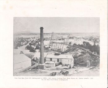
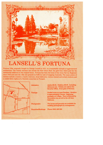
Pamphlet - Fortuna - Informatiopn Tourist Brochures, Early 2000s
... Fortuna was historically significant in Bendigo's deep alluvial gold mining operations.The site was purchased from the Crown in 1857 by Theodore Ballerstedt and his father, Christopher, who arrived in Bendigo in 1853 from California....Fortuna was historically significant in Bendigo's deep alluvial gold mining operations.The site was purchased from the Crown in 1857 by Theodore Ballerstedt and his father, Christopher, who arrived in Bendigo in 1853 from California. bendigo fortuna george lansell Ballerstadt Fortuna - Informatiopn Tourist Brochures This item contains the following documents: 11217.57a Four page colour brochure "Introducing the Defense Sire Fortuna - Centre pages contain a map of the site with prominant features. ...Defence Site Fortuna is a 7.5-hectare property located on the northern side of Chum Street at Golden Square, Bendigo, Victoria. The main building is Fortuna Villa, with additional structures including two accommodation buildings, a former mess building, storage buildings, and a parade ground. The property is owned by the Department of Defence. It was most recently used by the Defence Imagery and Geospatial Organisation (DIGO), which relocated in October 2008.The site is now surplus to Defence requirements, and investigations into its heritage and environmental values are underway to inform future disposal plans. Fortuna was historically significant in Bendigo's deep alluvial gold mining operations.The site was purchased from the Crown in 1857 by Theodore Ballerstedt and his father, Christopher, who arrived in Bendigo in 1853 from California.Fortuna - Informatiopn Tourist Brochures This item contains the following documents: 11217.57a Four page colour brochure "Introducing the Defense Sire Fortuna - Centre pages contain a map of the site with prominant features. Also parts of the back page describe " What is Happening at Fortuna"; significant values of the site and determination of disposal from the Defence Department. 11217.57b Four copies of A4 size coloured brochure, two-sided, tri-fold produced by the Villa Fortuna action Group 11217.57c A4 size coloured brochure, two-sided, tri-fold produced by the Bendigo Tourism Inc. Advertises two hour conductd and group tours 11217.57d Two copies of one page brochure advertiing guided toursnon-fictionbendigo, fortuna, george lansell, ballerstadt -
 Orbost & District Historical Society
black and white photograph, late 19th century - early 20th century
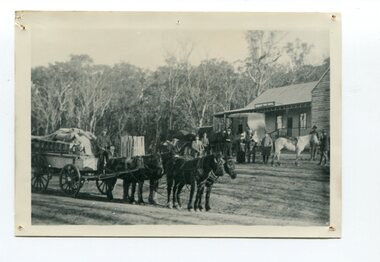
... In the late 1890s, small quantities of alluvial gold were found in the creek. A school commenced classes in 1913, but enrolment was small and at times the school operated part time with several other small schools in the area. ...In the late 1890s, small quantities of alluvial gold were found in the creek. A school commenced classes in 1913, but enrolment was small and at times the school operated part time with several other small schools in the area. ...This is a photograph of Alice Swallow's hotel at Cabbage Tree. The settlement of Cabbage Tree Creek is located on the Princes Highway, 27 km east of Orbost in East Gippsland. The first white settler arrived in the valley in 1887 cutting a dray track from Marlo to the south-west. Several families cleared the alluvial flats, growing maize, peas and beans and raising pigs, cattle and sheep. Later the farmers milked cows, sending cream to Orbost. In the late 1890s, small quantities of alluvial gold were found in the creek. A school commenced classes in 1913, but enrolment was small and at times the school operated part time with several other small schools in the area. The school building served as a hall for the district. From the 1920s the Cabbage Tree Hotel catered to drivers on the improved Princes Highway. (info. from Victorian Places)This is a pictorial record of Cabbage Tree, East Gippsland in the late 20th century. It shows a building that no longer exists.A black / white photograph of a small, single - storey wooden building in a bush setting. There are people standing in front of the building with a horse and wagon nearby. In the foreground is a wagon with four horses hitched to it and the driver seated behind the horses. -
 Orbost & District Historical Society
black and white photograph, late 19th century - early 20th century
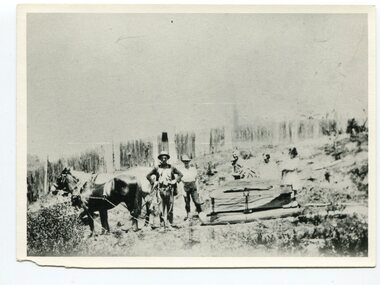
... From 1845 the Bendoc area was part of pastoral leases. In the 1850s alluvial gold was discovered in the Bendoc River. ...From 1845 the Bendoc area was part of pastoral leases. In the 1850s alluvial gold was discovered in the Bendoc River. ...This photograph shows land clearing at Bendoc. From 1845 the Bendoc area was part of pastoral leases. In the 1850s alluvial gold was discovered in the Bendoc River. This was quickly exhausted, and a number of mines began successful reef operations. At the head of the river, the settlement of Clarkville clustered round several other mines. Many miners, including numbers of Chinese, sluiced the rivers. The population of the area was as high as 500 during this period. The township was surveyed in 1869 and the hotel built in 1870. This building was burnt down in the early 1900s and rebuilt. A school was also begun at this time. In the 1870s there was a decline in gold mining. Some miners selected land, which in many cases is still held by descendants. Dairying was common in the early days, supplying a butter factory at the New South Wales border, and a milk factory at Orbost in more recent times. Wheat was grown for the settlers' own use and ground at Bombala. Now beef cattle grazing is the main occupation. (info. from Victorian Places)This is a pictorial history associated with the early settlement of Bendoc in East Gippsland.A badly distorted black / white photograph of a horse drawn wagon, three men and two women clearing land.on back - "Clearing land at Bendoc"bendoc-land-clearing bendoc-early-settlement -
 Orbost & District Historical Society
black and white photograph, 1920s -1930s
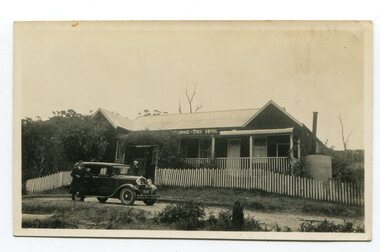
... In the late 1890s, small quantities of alluvial gold were found in the creek. A school commenced classes in 1913, but enrolment was small and at times the school operated part time with several other small schools in the area. ...In the late 1890s, small quantities of alluvial gold were found in the creek. A school commenced classes in 1913, but enrolment was small and at times the school operated part time with several other small schools in the area. ...The Cabbage Tree Creek township was originally established to support the booming timber industry of the mid 20th century. Five timber mills worked full time supporting the families that were drawn to the area's wealth of natural resources. The settlement of Cabbage Tree Creek is located on the Princes Highway, 27 km east of Orbost in East Gippsland. The first white settler arrived in the valley in 1887 cutting a dray track from Marlo to the south-west. Several families cleared the alluvial flats, growing maize, peas and beans and raising pigs, cattle and sheep. Later the farmers milked cows, sending cream to Orbost. In the late 1890s, small quantities of alluvial gold were found in the creek. A school commenced classes in 1913, but enrolment was small and at times the school operated part time with several other small schools in the area. The school building served as a hall for the district. From the 1920s the Cabbage Tree Hotel catered to drivers on the improved Princes Highway. (info. from Victorian Places)This is a pictorial record of Cabbage Tree, East Gippsland in the late 20th century. It shows a building that no longer exists.A small black / white photograph of a single storey timber building. On a sign below the roof is "Cabbage Tree Hotel". The hotel is surrounded by a wooden picket fence. A man and woman are standing on either side of a motor car parked on the roadway in front of the building.on back - on label - Cabbage Tree Hotelcabbage-tree-hotel -
 Wodonga & District Historical Society Inc
Photograph - North-Eastern Gold Days, 1900
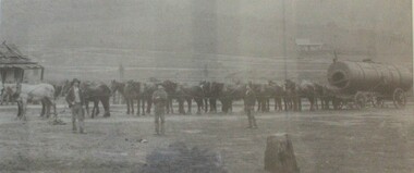
... Before 1876 gold mining in the Bethanga district occurred to the north of the town and was known as the 'Talgarno diggings'. Reports of alluvial gold date back to 1852. Early gold fields were worked at Ruby Creek, Gold Creek and Jarvis Creek. ...Before 1876 gold mining in the Bethanga district occurred to the north of the town and was known as the 'Talgarno diggings'. Reports of alluvial gold date back to 1852. Early gold fields were worked at Ruby Creek, Gold Creek and Jarvis Creek. ...Bethanga was established as a result of the discovery of gold. Gold was first reported in the Bethanga area in 1852. Before 1876 gold mining in the Bethanga district occurred to the north of the town and was known as the 'Talgarno diggings'. Reports of alluvial gold date back to 1852. Early gold fields were worked at Ruby Creek, Gold Creek and Jarvis Creek. The opening of the Bethanga goldfields began with the discovery of a gold-bearing quartz reef on New Year’s Day 1876. The 'Gift' mine site is located southeast of Kurrajong Gap lookout to the west of Bethanga township. The Great Eastern Copper Smelting Works was opened in 1878. Due to the nature of the gold-bearing quartz reef, the gold was difficult to extract, and the discovery of copper led to a change in focus. It was not until the early 1890s that an efficient technique for extracting the gold from the ore was discovered, and once again gold became the focus, with copper as a by-product. Bethanga was removed from the official list of goldfields in 1912, however some mining activity has taken place since.This image reflects an important time in the development of Bethanga and Northeast Victoria.A large mounted and framed image of horse teams and their owners hauling a large boiler to the gold mine near Bethanga, Victoria. On label beneath image: "North-eastern "Gold Days"/ Combined teams hauling a boiler to Bethanga Mines, 1900. Teamsters - Mr. G. Pearce, W. Chapple, G, Bannon." Donated by Ron Saunders and Barbara Cadman"bethanga, gold mining northeast victoria, gold mining bethanga, bethanga history -
Federation University Historical Collection
Map - Map - Geological, Geological Survey of Victoria - Ballarat, 09/1858
... The map show alluvial silt, gold drift, geological orders, volcanic, and gold workings. ...The map show alluvial silt, gold drift, geological orders, volcanic, and gold workings. ...Coloured Geological Map of Ballarat, edged with masking tape. The map show alluvial silt, gold drift, geological orders, volcanic, and gold workings. Scale is 8 chains to an inch. WGS 84 Centroid: 37 degrees 33 feet 33 inches south 143 degrees 52 feet 02 inches east W.E. extent: 5km NS extent: 3 kmballarat, ballaarat, geology, goldfield, phillips, j. phillips, mining, alfred selwyn, ferguson and mitchell