Showing 148 items matching "alpine area"
-
 Kiewa Valley Historical Society
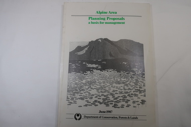
Book - Book - Alpine Area - Department of Conservation, Forests & Lands, Alpine Area / Planning Proposals / a basis for management. 1987
... Book - Alpine Area - Department of Conservation, Forests & Lands...Alpine Area / Planning Proposals / a basis for management. 1987...Alpine Area...It is the policy of the Government that most of the State's alpine area will be proclaimed as an Alpine National Park, which would complement the Kosciusko National Park in N.S.W.. ...The map is coloured green to indicate the planning area. Alpine Area / Planning Proposals / a basis for management. 1987 Book Book - Alpine Area - Department of Conservation, Forests & Lands ...It is the policy of the Government that most of the State's alpine area will be proclaimed as an Alpine National Park, which would complement the Kosciusko National Park in N.S.W.. This is yet to be achieved (1987), however there is a need for sound, efficient and coordinated management based on the area's natural features, values and uses. Planning is proceeding on this basis.Victoria's alpine area is one of the State's most outstanding and spectacular natural areas. It is noted for its diverse plant and animal life, scenery, recreation opportunities and as a water catchment. This country is at the upper end of the Kiewa Valley and the planning for it is of interest to the Kiewa Valley inhabitants.White bound book with green print for title at the top, black & white picture and black print at the bottom for the name of the government authority publishing the book.143 pages with fold out map after page 7. The map is coloured green to indicate the planning area.alpine area, bogong national park, victorian department of conservation forests & lands -
 Kiewa Valley Historical Society
Maps - Bogong x2, Tawonga, Omeo, Dargo, Victoria and others, 1. Bogong Alpine Area; 2. Bogong 8324; 3. Tawonga Topographical; 4. Omeo 8433; 5. Dargo 8323; 6. Victoria State
... 1. Bogong Alpine Area; 2. Bogong 8324; 3. Tawonga Topographical; 4. ......bogong alpine area...1. Bogong Alpine Area (outdoor Leisure Map. survey & Mapping Victoria, Government of Victoria, Edition 2, reprinted 1991 with an image of Mt. ...Scale 1: 850,000 1. Bogong Alpine Area; 2. Bogong 8324; 3. Tawonga Topographical; 4. ...1. Bogong Alpine Area (outdoor Leisure Map. survey & Mapping Victoria, Government of Victoria, Edition 2, reprinted 1991 with an image of Mt. Feathertop on the front. Information for tourist in the Alpine National Park: Bogong Area. Including: recreational activities, history, weather and vegetation and a list of walks together with locality maps and photographs. The front cover has an image of Mt Feathertop against a blue sky with yellow writing 'Bogong Alpine Area', there is a yellow triangular block on the right hand top corner with black writing 'Outdoor Leisure Map. On the bottom edge is a block of yellow with black writing 'Survey & Mapping Victoria' and a light green map of Victoria with 'VICMSP' printed in white. 2. 8324 Bogong Victoria, Edition 1, Commonwealth of Australia 1981. A topographical Map: 1:100,000 scale (1 cm to 1 KM). Map has a red cover with white writing together with a white block and black writing and a map insert. 3. Tawonga Topographical Map - Forests Commission Victoria, / revised 5/9/77, DEG No. 68-G/399. A Tawonga 803 folded map in a beige colour with the back blank. 4. Omeo 8433 Victoria, Edition 1, Department of Natural Resources. The map has a red and white cover with black writing and a simple map of Australia at the bottom. 5. 8323 Dargo, Edition 1, Commonwealth of Australia. A red and white cover with a map insert. 6. Victoria State Map, Hema Maps, 2002. Hema Maps, State Map, colourful cover with a map of Australia and four tourism photographs. Scale 1: 850,000 An inscription handwritten in blue pen "Trappers Gap to Mitta Mitta 1" to 1 mile". There are some pen markings and notations of tracks.maps, bogong, omeo, tawonga, dargo, victoria, bogong alpine area -
 Kiewa Valley Historical Society
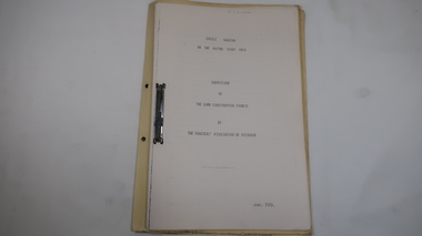
Report - Alpine Area Proposed Recommendations, Land Conservation Council, Victoria Melbourne, April 1978, April 1978
... Report - Alpine Area Proposed Recommendations...alpine area...Of interest for research on the changing ideas regarding the use of public land and the environment. alpine area land conservation council alpine study area report Blue book bound by dark blue cloth tape. ...The Land Conservation Council was established by the Land Conservation Act 1970. It makes recommendations to the Minister for Conservation with respect to the use of public land. Notices showing the boundary of the study area ... published in the Victorian Government Gazette Sept. 1973. A descriptive report was published in July 1977. Submissions (1538) on the future use of public land were received & included those representing a wide cross-section of the community. These were considered in the final report.Of interest for research on the changing ideas regarding the use of public land and the environment.Blue book bound by dark blue cloth tape. It has 92 pages with maps at the end and an empty folder inside the back cover.alpine area, land conservation council, alpine study area report -
 Kiewa Valley Historical Society
Report - Alpine Study Area Volume 2 Maps, Land Conservation Council, 1970s
... Report - Alpine Study Area Volume 2 Maps...alpine area...Blue box shaped folder containing 9 of 10 Maps of the Alpine Study Area produced by the Land Conservation Council. ...Others may provide information for future development such as mineral exploration, building of a dam / tunnel etc. alpine area maps of alpine area land conservation council Ex library item. ...The Victorian Environmental Assessment Council and the former Environment Conservation Council (ECC) and Land Conservation Council (LCC) have completed 36 land use investigations over more than 35 years, including 27 regional reviews. They provide a framework for use of Public Land in Victoria. The Land Conservation Council was established by the Land Conservation Act 1970.These maps provide an assessment of the Alpine area at the time the maps were created. Some of the topics eg. Rainfall and water resources may change over the years thus providing a comparative analysis. Others may provide information for future development such as mineral exploration, building of a dam / tunnel etc.Blue box shaped folder containing 9 of 10 Maps of the Alpine Study Area produced by the Land Conservation Council. Maps include 1. Public land and descriptive blocks. 2. Physiography. 3. Topography. 4. Geology (missing). 5. Rainfall and water resources. 6. Vegetation 7. Land systems. 8. Recreation. 9. Primary production. 10. Minerals Ex library item. Stamped in red "Discarded From Stock / Swan Hill Regional Libraryalpine area, maps of alpine area, land conservation council -
 Lakes Entrance Historical Society
Book, Land Conservation Council Victoria Alpine Area, 1977
... Land Conservation Council Victoria Alpine Area...Report containing information from various sources relevant to the future use of public land in the alpine area of Victoria. History, climate, landform, vegetation, land use, are some of the aspects presented....Land Conservation Council Victoria Alpine Area Book ...Report containing information from various sources relevant to the future use of public land in the alpine area of Victoria. History, climate, landform, vegetation, land use, are some of the aspects presented.Ruth Clarktopography, vegetation -
Lakes Entrance Historical Society
Map - Alpine Study Area Public Land and Blocks, Land Conservation Council
... Alpine Study Area Public Land and Blocks...Map showing public land and descriptive blocks in the Alpine area with names and numbers...Lakes Entrance Historical Society 4 Marine Parade Lakes Entrance gippsland study Land conservation Map No. 1 Map showing public land and descriptive blocks in the Alpine area with names and numbers Map Alpine Study Area Public Land and Blocks Land Conservation Council ...Map showing public land and descriptive blocks in the Alpine area with names and numbersMap No. 1study, land conservation -
Lakes Entrance Historical Society
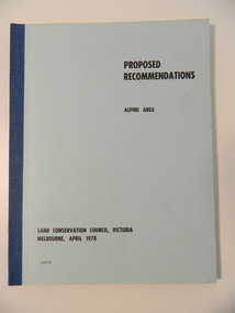
Book, Land Conservation Council, Proposed Recommendations Alpine Area Land Conservation 1978, 1978
... Proposed Recommendations Alpine Area Land Conservation 1978...Lakes Entrance Historical Society 4 Marine Parade Lakes Entrance gippsland Land conservation Alpine Region recommendations Proposal by Land Conservation Council with recommendations for Alpine Area with maps Soft cover book blue cover with 100 pages Proposed Recommendations Alpine Area Land Conservation 1978 Book Land Conservation Council ...Proposal by Land Conservation Council with recommendations for Alpine Area with mapsSoft cover book blue cover with 100 pagesnon-fictionProposal by Land Conservation Council with recommendations for Alpine Area with mapsland conservation, alpine region, recommendations -
Lakes Entrance Historical Society
Book, Land Conservation Council, Final Recommendations Alpine Area, 1979
... Final Recommendations Alpine Area...Lakes Entrance Historical Society 4 Marine Parade Lakes Entrance gippsland Land conservation Reports recommendations Final recommendations for Alpine Area from Land Conservation Council of Victoria told on text and maps Blue cover 89 pages plus maps Final Recommendations Alpine Area Book Land Conservation Council ...Final recommendations for Alpine Area from Land Conservation Council of Victoria told on text and mapsBlue cover 89 pages plus mapsnon-fictionFinal recommendations for Alpine Area from Land Conservation Council of Victoria told on text and mapsland conservation, reports, recommendations -
Koorie Heritage Trust
Book, Beauglehole, A. C, The distribution and conservation of vascular plants in the alpine area, Victoria, 1981
... The distribution and conservation of vascular plants in the alpine area, Victoria...The distribution and conservation of vascular plants in the alpine area, Victoria Book Beauglehole, A. C. ...One col. map on folded leaf in pocket. Bibliography: p. 9-11.indigenous vascular plants. distribution. victoria. alpine regions | botany -- victoria. -
 Kiewa Valley Historical Society
Folder - Cattle Grazing, Cattle Grazing in the Alpine Study Area
... Cattle Grazing in the Alpine Study Area...Dated: June 1978 Cattle Grazing in the Alpine Study Area Folder - Cattle Grazing ...Cattlemen / Beef Farmers of the Kiewa Valley took their cattle up to the High Plains to graze during summer.Cover includes the heading 'National Parks Service' and is bound on the spine with black tape. This is followed by 'File Title' on yellow cardboard marked with column and lines. Inside: 35 pages printed on one side. Pages are bound by steel binder. Dated: June 1978J. Commins on cover page at the top.bogong high plains, cattle grazing, farmers of the kiewa valey, national parks -
Lakes Entrance Historical Society
Map - Alpine Study Area - Physiography, Land Conservation Council
... Alpine Study Area - Physiography...Lakes Entrance Historical Society 4 Marine Parade Lakes Entrance gippsland physiography study Land conservation Map No. 2 Map shows mountanous tracts, tablelands and plataux basins Map Alpine Study Area - Physiography Land Conservation Council ...Map shows mountanous tracts, tablelands and plataux basinsMap No. 2physiography, study, land conservation -
Lakes Entrance Historical Society
Map - Alpine Study Area - Topography, Land Conservation Council
... Alpine Study Area - Topography...Lakes Entrance Historical Society 4 Marine Parade Lakes Entrance gippsland Topography study Conservation Map No. 3 Map shows Great Dividing Range Map Alpine Study Area - Topography Land Conservation Council ...Map shows Great Dividing RangeMap No. 3topography, study, conservation -
Lakes Entrance Historical Society
Map - Alpine Study Area - Geology, Land Conservation Council
... Alpine Study Area - Geology...Lakes Entrance Historical Society 4 Marine Parade Lakes Entrance gippsland Geology study Land conservation Map No. 4 Map shows mountain ranges and rivers Map Alpine Study Area - Geology Land Conservation Council ...Map shows mountain ranges and riversMap No. 4geology, study, land conservation -
Lakes Entrance Historical Society
Map - Alpine Study Area - Rainfall, Land Conservation Council
... Alpine Study Area - Rainfall...Signature Ruth Clark Map shows rainfall and water resources Golbourn River, Ovens River, Macalister Riverr Kiewa River, Mitta Mitta River, Murrary River and Snowy River Map Alpine Study Area - Rainfall Land Conservation Council ...Map shows rainfall and water resources Golbourn River, Ovens River, Macalister Riverr Kiewa River, Mitta Mitta River, Murrary River and Snowy RiverMap 5. Signature Ruth Clarkwater resources, rainfall, study -
Lakes Entrance Historical Society
Map - Alpine Study Area - Vegetation, Land Conservation Council
... Alpine Study Area - Vegetation...Lakes Entrance Historical Society 4 Marine Parade Lakes Entrance gippsland Vegetation study Land conservation Map No. 6 Map shows tree names in each forest area as open forest, woodland and forest, cleared land. Map Alpine Study Area - Vegetation Land Conservation Council ...Map shows tree names in each forest area as open forest, woodland and forest, cleared land.Map No. 6vegetation, study, land conservation -
Lakes Entrance Historical Society
Map - Alpine Study Area - Land Systems, Land Conservation Council
... Alpine Study Area - Land Systems...Lakes Entrance Historical Society 4 Marine Parade Lakes Entrance gippsland Topography Land Systems Conservation Map No. 7 Map shows land systems, bounderies in the Great Dividing Range Map Alpine Study Area - Land Systems Land Conservation Council ...Map shows land systems, bounderies in the Great Dividing RangeMap No. 7topography, land systems, conservation -
Lakes Entrance Historical Society
Map - Alpine Study Area - Recreation, Land Conservation Council
... Alpine Study Area - Recreation...Lakes Entrance Historical Society 4 Marine Parade Lakes Entrance gippsland Recreation Recreation Facilities study Map No. 8 Map shows historic features, natural features, facilities, road access, walking tracks Map Alpine Study Area - Recreation Land Conservation Council ...Map shows historic features, natural features, facilities, road access, walking tracksMap No. 8recreation, recreation facilities, study -
Lakes Entrance Historical Society
Map - Alpine Study Area - Primary Production, Land Conservation Council
... Alpine Study Area - Primary Production...Public area, uncleared area, cattle main stock route, Map Alpine Study Area - Primary Production Land Conservation Council ...Map shows private land, cropping, sheep, cattle, dairy farm, tobacco farm, walnut, chestnuts, apples. Public area, uncleared area, cattle main stock route,Map No. 9crops, livestock, study, primary production -
Lakes Entrance Historical Society
Map - Alpine Study Area - Minerals, Land Conservation Council
... Alpine Study Area - Minerals...Extractive industries material Map Alpine Study Area - Minerals Land Conservation Council ...Map shows Cassilis goldfields 1. Metallic mineral deposits. 2. Non metallic mineral deposits. 3. Fuel mineral deposits. 4. Extractive industries materialMap 10minerals, study, goldfields -
Lakes Entrance Historical Society
Book, Johnson, Dick, The Alps at the Crossroads, 1974
... Contains historical evidence of the use and misuse of the Alpine area and the need for management of this special environment by the establishment of an Alpine National Park. ...Lakes Entrance Historical Society 4 Marine Parade Lakes Entrance gippsland Environment Settlement Contains historical evidence of the use and misuse of the Alpine area and the need for management of this special environment by the establishment of an Alpine National Park. ...Contains historical evidence of the use and misuse of the Alpine area and the need for management of this special environment by the establishment of an Alpine National Park. Many illustrations and maps.environment, settlement -
University of Melbourne, Burnley Campus Archives
Map, Kosciusko Primitive Area, Vegetation & Associated Features, 1972
... area...alpine vegetation...University of Melbourne, Burnley Campus Archives 500 Yarra Boulevard Richmond melbourne vegetation Mount Kosciusko area alpine vegetation D.J. Wimbush R.T. Morland 2 copies of map dated 1972 by Division of Plant Industry, Commonwealth Scientific and Industrial Research Organization. ...2 copies of map dated 1972 by Division of Plant Industry, Commonwealth Scientific and Industrial Research Organization. Shows: General Vegetation Approximately 2,000 feet-7,000 feet; and Alpine and Subalpine Complex Approximately 5,000 feet-7,000 feet. Scale 1:31,680.vegetation, mount kosciusko area, alpine vegetation, d.j. wimbush, r.t. morland -
 Falls Creek Historical Society
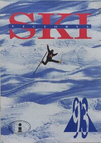
Booklet - Ski Victoria Information Brochure 93
... A part of a yearly marketing and information material promoting the Victorian Alpine Area and packages available for the 1993 winter season....Falls Creek Historical Society Slalom Street Falls Creek A part of a yearly marketing and information material promoting the Victorian Alpine Area and packages available for the 1993 winter season. ...A part of a yearly marketing and information material promoting the Victorian Alpine Area and packages available for the 1993 winter season.This item is important as it documents seasonal activities at Falls Creek Alpine Resort An A4 sized marketing booklet, including images and advertising information printed on glossy paper.victorian alpine region, falls creek marketing, accommodation falls creek -
 Kiewa Valley Historical Society
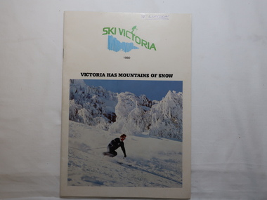
Magazine - Ski Victoria 1980
... It has only been popular since the 1950s however, when the Alpine areas were opened up to commercial development."...It has only been popular since the 1950s however, when the Alpine areas were opened up to commercial development." ...The introduction: "Skiing has been a sport in Victoria since the turn of the century. It has only been popular since the 1950s however, when the Alpine areas were opened up to commercial development."Employees of the SECV skied on the High Plains during the construction of the KHES. In 1946 the first lodge was approved by the SEC at Falls Creek. See Falls Creek pages 6-11 for details of amenities in 198048 pages held by 2 staples. 1980 Issue. Front Cover "Victoria has mountains of snow". In color - skier in front of trees laden with snow.Front cover in pen and underlined "J. Watson"falls creek ski resort, snow sport -
 Falls Creek Historical Society
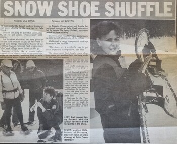
Article - Snow Shoe Shuffle, 30 July 1986
... The two hour "shuffle" took participants up into the sub-alpine area of the village. The snow shoe lessons had been held for the previous two seasons. ...The two hour "shuffle" took participants up into the sub-alpine area of the village. The snow shoe lessons had been held for the previous two seasons. ...This article reports on the latest fad - snow shoe lessons, being conducted at Falls Creek by Ms Jenny Bolwell for the Forests, Conservation and Lands Department in 1986. The two hour "shuffle" took participants up into the sub-alpine area of the village. The snow shoe lessons had been held for the previous two seasons. Bookings were available each Tuesday and Saturday during the snow season.This article is significant because it documents the variety of activities available at Falls Creek during its development.A newspaper item about the new fad at Falls Creek - snow shoeing.snow shoes, falls creek activities -
 Kiewa Valley Historical Society
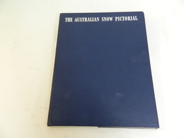
Book - Miscellaneous - Pictorial - Snow, Georgian House, The Australian Snow Pictorial, c1952
... The subject is Alpine resorts and ski areas in the Australian High Country in the 40s and 50s. ...The subject is Alpine resorts and ski areas in the Australian High Country in the 40s and 50s. ...This book records the history of skiing in Victoria with photos of places and people showing equipment used in the snow fields and used by skiers.Falls Creek and the Bogong High Plains are included in this book showing photos of local people and machinery etc. Dorothy Anderson (nee Ryder) owned and used this book. She lived at Tawonga.This is a bound pictorial book with a blue cover and white printed title.. The subject is Alpine resorts and ski areas in the Australian High Country in the 40s and 50s. 'To our very dear friends, Mr and Mrs Ryder, with our best wishes for a Merry Christmas & a Happy New Year from Harold and 'Rel / Ril ?' 'snow, skiing, photography, pioneers, enthusiasts, heritage, st elmo, secv machinery, ryder family, bogong high plains, rope tow -
Lakes Entrance Historical Society
Map - Grant Historic Adventurer, Paolett Adventure Maps, March 1998
... McMillans walking track, picnic areas, camping areas, Alpine National Park 1 page Included with map is a flyer for township of Grant compiled by Friends of Grant 10517A...McMillans walking track, picnic areas, camping areas, Alpine National Park 1 page Included with map is a flyer for township of Grant compiled by Friends of Grant 10517A Map Grant Historic Adventurer Paolett Adventure Maps ...Shows sealed and unsealed roads, rivers or creeks. McMillans walking track, picnic areas, camping areas, Alpine National Park 1 page Included with map is a flyer for township of Grant compiled by Friends of Grant 10517Aforest, recreation, townships, roads and streets, parks -
 Kiewa Valley Historical Society
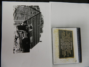
Wilkinson Lodge - copies of 6 photos, 1 plaque, 1 article
... It is also an early built lodge owned briefly 1946 - 1958 by the Ski Club of Victoria / Victorian Alpine Club and used by skiers before other lodges were built at Falls Creek. It was used by bushwalkers until it was burnt down thus in itself depicting part of the history of the area. ...Wilkinson's Hut was built for the State Electricity Commission of Victoria in 1932 as a permanent residence for the snow research program manager, who was the resident engineer of the Kiewa Hydro Electric Scheme. The hut was sold in 1948 to the Ski Club of Victoria / Victorian Alpine Club and renamed Wilkinson Lodge. In 1958 it was sold to the Melbourne Bushwalkers Club. It was burnt down on 17th January 2004.Wilkinson Lodge was located at Wallace Gap on the Bogong High Plains and was the first S.E.C.V. permanent residence for the workers of the Kiewa Hydro Electric Scheme. It is also an early built lodge owned briefly 1946 - 1958 by the Ski Club of Victoria / Victorian Alpine Club and used by skiers before other lodges were built at Falls Creek. It was used by bushwalkers until it was burnt down thus in itself depicting part of the history of the area.5 pages of copies of photos of Wilkinson Lodge, 1 page of a copy of the destruction of Wilkinson Lodge (6 small photos), 1 page of a copy of a plaque titled 'This cottage' and 1 page of an article from the Border Mail (newspaper) dated 19th Jan. 2004.wilkinson hut; secv; ski club of victoria; melbourne bushwalkers club; fire -
 Kiewa Valley Historical Society
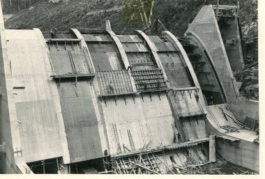
Photo - Junction Dam Construction, Circa 1940's
... Guy who was the Resident engineer, in charge of construction work and associated activities on the Kiewa Area from 1939 to November 1946 Photos of the construction of the Junction Dam detail the harsh conditions faced by construction workers, building dams and villages to accommodate workers in the 1940s to the 1950s. Australia at this period in time, experienced a surge of population (influx of World War II refugees), which was the catalyst for developing and undergoing an enormous hydroelectricity program for the Alpine regions, both in Victoria and New South Wales. ...Junction (Lake Guy) Dam is a 'slab and buttress' type wall. A timber frame is built and then filled with concrete. The first batch of concrete was placed in September, 1940. By June, 1941 the buttresses were finished to a height safe from floods and in October of that year a flood of 2,800 cusecs occurred but with only slight damage to the installations. Industrial trouble caused some delays but there was also slow progress on the part of the contractor and the work was taken over by the S.E.C., terminating the contract. The dam was completed in March, 1944. A walkway was made through the dam wall. Lake Guy was named after Mr. L.T. Guy who was the Resident engineer, in charge of construction work and associated activities on the Kiewa Area from 1939 to November 1946Photos of the construction of the Junction Dam detail the harsh conditions faced by construction workers, building dams and villages to accommodate workers in the 1940s to the 1950s. Australia at this period in time, experienced a surge of population (influx of World War II refugees), which was the catalyst for developing and undergoing an enormous hydroelectricity program for the Alpine regions, both in Victoria and New South Wales. This program was initiated to supply electricity to the major southern Australian cities of Adelaide, Melbourne and Sydney. It was thought that these developments would reduce, if not eliminate, the requirement for coal driven power stations. However time has demonstrated that these power stations have not matched the demand required by the industries and the populations of the major urban and cities.Black and white photograph of Junction Dam constructionjunction dam, bogong, secv -
 Kiewa Valley Historical Society
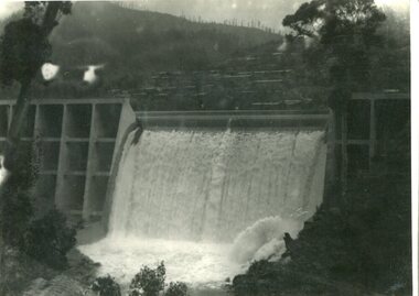
Photograph - Junction Dam spilling
... Guy who was the Resident engineer, in charge of construction work and associated activities on the Kiewa Area from 1939 to November 1946 Photos of the construction of the Junction Dam detail the harsh conditions faced by construction workers, building dams and villages to accommodate workers in the 1940s to the 1950s. Australia at this period in time, experienced a surge of population (influx of World War II refugees), which was the catalyst for developing and undergoing an enormous hydroelectricity program for the Alpine regions, both in Victoria and New South Wales. ...Junction (Lake Guy) Dam is a 'slab and buttress' type wall. A timber frame is built and then filled with concrete. The first batch of concrete was placed in September, 1940. By June, 1941 the buttresses were finished to a height safe from floods and in October of that year a flood of 2,800 cusecs occurred but with only slight damage to the installations. Industrial trouble caused some delays but there was also slow progress on the part of the contractor and the work was taken over by the S.E.C., terminating the contract. The dam was completed in March, 1944. A walkway was made through the dam wall. Lake Guy was named after Mr. L.T. Guy who was the Resident engineer, in charge of construction work and associated activities on the Kiewa Area from 1939 to November 1946Photos of the construction of the Junction Dam detail the harsh conditions faced by construction workers, building dams and villages to accommodate workers in the 1940s to the 1950s. Australia at this period in time, experienced a surge of population (influx of World War II refugees), which was the catalyst for developing and undergoing an enormous hydroelectricity program for the Alpine regions, both in Victoria and New South Wales. This program was initiated to supply electricity to the major southern Australian cities of Adelaide, Melbourne and Sydney. It was thought that these developments would reduce, if not eliminate, the requirement for coal driven power stations. However time has demonstrated that these power stations have not matched the demand required by the industries and the populations of the major urban and cities.Black and white photograph of Junction Dam spilling at Bogong VillageHandwritten in pencil - Junction Dam spillingbogong, junction dam, lake guy, secv -
 Kiewa Valley Historical Society
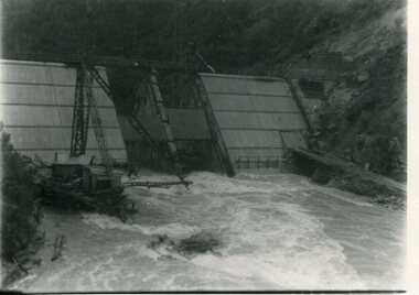
Photograph - Kiewa River in flood at Clover Dam
... The Kiewa valley and its surrounding alpine catchment were looked at(Victorian State Government), from the beginning of the twentieth century as a source of alternate power for an ever-increasing demand for electricity by growing population and heavy industrial areas within Melbourne City and State regions. ...As part of the push to cut electricity costs and diversify supply, the Victorian Government (circa 1930) implemented the conversion strategy from mainly brown coal supply to hydro - electricity. The Kiewa Hydroelectric Scheme became the largest scheme of its kind in the State Of Victoria and the second largest scheme in Australia. Clover Dam and Power Station were built by the State Electricity Commission of Victoria as part of the Kiewa Hydro Electric Scheme from the late 1930's to the early 1940's. This dam was constructed to supply water to feed four turbines (62 mega watts) at the West Kiewa Power Station. This was at the forefront of sustainable "Green" energy. Costs associated with power supplies is still a major incentive of governments, however environmentally friendly alternatives such as wind and nuclear have also made inroads. The Kiewa valley and its surrounding alpine catchment were looked at(Victorian State Government), from the beginning of the twentieth century as a source of alternate power for an ever-increasing demand for electricity by growing population and heavy industrial areas within Melbourne City and State regions. Construction of dams, such as Clover Dam provided the large quantity holding areas of water required to turn the turbines at the various power stations to provide the electricity needed. The impact of these controls by moderating water run-off from the alpine regions is beneficial in reducing flooding from thawing of snow on the alps. This by-product allows agriculture and grazing to be less vulnerable to seasonal flooding thereby resulting in a more stable annual production level.Black and white photograph of Clover Dam with Kiewa River in flood. .5mm white boarder on 3 sides of photo.Handwritten on back of photograph in black pen - Kiewa in flood. Clover Dam.clover dam, secv