
Showing 3183 items matching "australia maps"
-
 Ringwood RSL Sub-Branch
Map - Assorted maps around Australia, Maps
... Assorted maps around Australia...Australian maps...Australian maps Maps Map Assorted maps around Australia ...Australian maps -
 Greensborough Historical Society
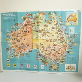
Poster - Map, International Harvester, Australia. Land of tomorrow, 1965_
... ...australia maps...This 1960s map of Australia shows areas of economic development at that time....Colour map of Australia with inset illustrations...This 1960s map of Australia shows areas of economic development at that time. australia economic development international harvester australia maps Colour map of Australia with inset illustrations Australia. ...This 1960s map of Australia shows areas of economic development at that time.Colour map of Australia with inset illustrationsaustralia economic development, international harvester, australia maps -
 Montmorency–Eltham RSL Sub Branch
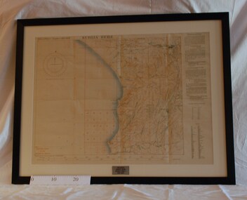
Map - Framed Japanese Map of Darwin Circa 1942, WW2 Japanese Map of Darwin, Estimated date 1940-41
... australia...1942...1941...maps...'This map is a proof copy of a Japanese Reprint of an Australian map of Darwin.'...Returned to Australia, from America, where it had been brought back from Japan. darwin world war two japan australia 1942 1941 maps 'This map is a proof copy of a Japanese Reprint of an Australian map of Darwin.' ...Returned to Australia, from America, where it had been brought back from Japan.Framed map of Darwin with Japanese overprint.'This map is a proof copy of a Japanese Reprint of an Australian map of Darwin.'darwin, world war two, japan, australia, 1942, 1941, maps -
 Tatura Irrigation & Wartime Camps Museum
Sculpture - Sandstone Maps of Australia, 1940
... Sandstone Maps of Australia...2x hand carved sandstone maps of Australia with space for penny in one & metal kangaroo in other. 1. ...Sculpture Sandstone Maps of Australia ...2x hand carved sandstone maps of Australia with space for penny in one & metal kangaroo in other. 1. Space for penny in centre. Markings for state boundaries. Creamy coloured stone. 2. Metal (copper?) kangaroo in centre. Pink tinged stone.1. Tatura 1940 2. 1940 Taturatatura;, handcrafts, carving -
Moorabbin Air Museum
Map (item) - Aeronautical colour map Feb 1944 cloth backed extends to port Augusta Newcastle and Melbourne 1960'c A4 size civil aviation airport terminal maps of Melbourne Brisbane Darwin Adelaide Hobart Launceston Perth 1943 Cloth map of Burma 1943 cloth map of Indonesia 1957 war office Cloth map of Singapore Bangkok North Borneo Ordinance maps 3108 Brunswick bay 3222 Halls creek 3232 Alice Springs 3098 Cape Wessel 3221 Newcastle waters 3223 Broome 3109 Darwin 3097 Torres Strait 3110 Groote Eylandt 3099 Melville Island 3112 Cooktown 3459 Port Augusta 3340 Brisbane 3470 Melbourne 3456 Sydney 3469 Hamilton, Maps of Australia and environs
... Maps of Australia and environs...Cloth maps fair condition, the rest Good condition Maps of Australia and environs Map Aeronautical colour map Feb 1944 cloth backed extends to port Augusta Newcastle and Melbourne 1960'c A4 size civil aviation airport terminal maps of Melbourne Brisbane Darwin Adelaide Hobart Launceston Perth 1943 Cloth map of Burma 1943 cloth map of Indonesia 1957 war office Cloth map of Singapore Bangkok North Borneo Ordinance maps 3108 Brunswick bay 3222 Halls creek 3232 Alice Springs 3098 Cape Wessel 3221 Newcastle waters 3223 Broome 3109 Darwin 3097 Torres Strait 3110 Groote Eylandt 3099 Melville Island 3112 Cooktown 3459 Port Augusta 3340 Brisbane 3470 Melbourne 3456 Sydney 3469 Hamilton ... -
 Wodonga & District Historical Society Inc
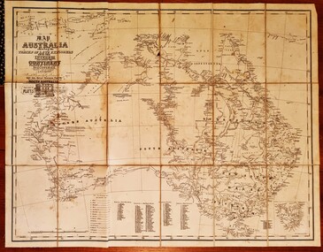
Map - Australia Shewing the Tracks of the Late Explorers
... Explorers -- Australia -- Maps...Australia, serving from 24 October 1856 to 20 August 1857. In 1864 he was appointed as the Government Resident of the Northern Territory. He was filling this role at the time when the map...Map of Australia and part of Indonesia. Part coloured with tracks of 15 explorers including Eyre, Stuart, Leichhardt and Burke and Wills with notes and some details of latitude and longitude. ...Map of Australia shewing the tracks of late explorers into the interior and across the continent together with their discoveries map/ projected, compiled and drawn by O.W.O. ...BOYLE TRAVERS FINISS Government Resident of the Northern Territory of SOUTH AUSTRALIA Map of Australia and part of Indonesia. ...Charles George Eastland Platts arrived in South Australia on 22 March 1839, and soon after established his business in Adelaide. He became Adelaide’s first bookseller. It was known as Platts’ Library but was also a bookshop and stationer. His business was also used as a postal receiving house. Platts died on 14 November 1871. Boyle Travers Finniss (18 August 1807 – 24 December 1893) had an early career in the British Military before selling off his commission in 1835. He was appointed assistant surveyor to Colonel William Light in South Australia. He then had several roles in public service. Finniss was the first premier and Chief Secretary South Australia, serving from 24 October 1856 to 20 August 1857. In 1864 he was appointed as the Government Resident of the Northern Territory. He was filling this role at the time when the map was produced and is acknowledged on the map.This is a very early map documenting the exploration and opening up of Australia.Map of Australia and part of Indonesia. Part coloured with tracks of 15 explorers including Eyre, Stuart, Leichhardt and Burke and Wills with notes and some details of latitude and longitude. Relief relating to the major mountain ranges is indicated. At the bottom of the map is a key to the explorers and a list of the counties in the different states. Top left side of map has small sketch of the Platts (publisher) building at the corner of King William Street.Map of Australia shewing the tracks of late explorers into the interior and across the continent together with their discoveries map/ projected, compiled and drawn by O.W.O. Bennett Most Respectfully Dedicated to LIEUT. COL. BOYLE TRAVERS FINISS Government Resident of the Northern Territory of SOUTH AUSTRALIAexplorers -- australia -- maps, rare maps australia -
Emerald Museum & Nobelius Heritage Park
Map - Local map, Regional Publicity Service, Today's Map of the Dandenong Ranges, Districts & Environs with complete Alphabetical Streets, Index and Locations of schools, churches, public buildings, hospitals, child welfare centres, police stations, post offices and public telephone boxes, 1957
... ... Australia...maps...Emerald Victoria Australia maps Dandenong Ranges Victoria Australia Advertising dandenong ranges Regional Publicity Service Blue advertising booklet containing an open-up map of Dandenong RangesPaper Today's Map of the Dandenong Ranges, Districts & Environs with complete Alphabetical Streets, Index and Locations of schools, churches, public buildings, hospitals, child welfare centres, police stations, post offices and public telephone boxes Map Local map Regional Publicity Service ...Map kept for the advertisements within which are relevant to Emerald.Blue advertising booklet containing an open-up map of Dandenong RangesPaperemerald, victoria, australia, maps, dandenong ranges, victoria, australia, advertising, dandenong ranges, regional publicity service -
Emerald Museum & Nobelius Heritage Park
Map - South Gippsland map, Broadbents Official Map of South Gippsland
... ... Australia...maps...touring map of South Gippsland Emerald Victoria Australia maps tourism Gippsland Broadbent Folded map of South Gippsland Broadbents Official Map of South Gippsland Map South Gippsland map ...touring map of South GippslandFolded map of South Gippslandemerald, victoria, australia, maps, tourism, gippsland, broadbent -
Emerald Museum & Nobelius Heritage Park
Map - Geological Survey Map 1882, Mines Department, Victoria, 1969
... ... Australia...maps...Emerald Victoria Australia Dandenong Ranges Victoria Australia maps geology Department of Mines Victoria Coloured map of geological survey of Ringwood geological zone. ...Part of geological survey of Victoria by Department of Mines. Includes Emerald.Coloured map of geological survey of Ringwood geological zone. Scale 1 mile to 1 inch. Laminated.emerald, victoria, australia, dandenong ranges, victoria, australia, maps, geology, department of mines, victoria -
Emerald Museum & Nobelius Heritage Park
Map - Dandenong Roads map, Broadbent's Map No 236 The Dandenongs
... ... Australia...maps...Tourist map, undated but predates construction of Cardinia Reservoir. Emerald Victoria Australia Dandenong Ranges Victoria Australia maps tourism Broadbent Maps Road map of the Dandenong Ranges with roads marked in black and red. ...Tourist map, undated but predates construction of Cardinia Reservoir.Road map of the Dandenong Ranges with roads marked in black and red. Includes smaller map showing approaches to the Dandenongs.emerald, victoria, australia, dandenong ranges, victoria, australia, maps, tourism, broadbent maps -
 Wimmera Mallee Pioneer Museum, Jeparit
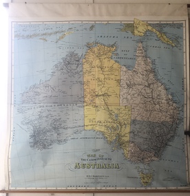
Map - Lithograph map of the Commonwealth of Australia, 1940s
... Lithograph map of the Commonwealth of Australia...Australia...maps...A map typically displayed in Australian schools mid-twentieth century. ...Colour lithograph map of the Commonwealth of Australia produced by H.E.C. Robinson Pty Ltd, Sydney, proably 1940s. ...Likely displayed in one of the local district's state schools, 1940s-1950s. Australia maps Colour lithograph map of the Commonwealth of Australia produced by H.E.C. ...A map typically displayed in Australian schools mid-twentieth century. Likely displayed in one of the local district's state schools, 1940s-1950s.Colour lithograph map of the Commonwealth of Australia produced by H.E.C. Robinson Pty Ltd, Sydney, proably 1940s. Sixth edition. Map No. 508C. Timber rods top and bottom.australia, maps -
Emerald Museum & Nobelius Heritage Park
Map - Gembrook Map, Dept. of Lands and Survey, 20/4/1892
... ... Australia...maps...Emerald Victoria Australia maps land settlement railway maps Department of Lands and Survey Victoria Gembrook: Counties of Evelyn and Mornington. ...Pen markings show railway and developed blocks in 1899 by AJM. Price 1/-. Shows owner / land, size of blocks / railway / includes townships / Emerald in Evelyn.Gembrook: Counties of Evelyn and Mornington. Second issue. Black and white map pasted to brown paper marked with pen.emerald, victoria, australia, maps, land settlement, railway maps, department of lands and survey, victoria -
Emerald Museum & Nobelius Heritage Park
Map - Gembrook Map, Dept. of Lands and Survey
... ... Australia...maps...Emerald Victoria Australia maps land settlement railway maps Department of Lands and Survey Victoria Counties of Evelyn and Mornington [Facsimile]. ...Map is undated but probably circa 1900 - includes railway through Emerald. Map shows owners of land, size of blocks, and nature of reserved land. 1961 reprint.Counties of Evelyn and Mornington [Facsimile]. Laminated reproduction of map.emerald, victoria, australia, maps, land settlement, railway maps, department of lands and survey, victoria -
Emerald Museum & Nobelius Heritage Park
Map - Subdivision Plan
... Macclesfield Victoria Australia...maps...Emerald Victoria Australia Macclesfield Victoria Australia maps Map. Subdivision of Nangana (portion). ...Map. Subdivision of Nangana (portion). Land V C Hootlenstein outlined in red. Sold for ú800 in 1939.emerald, victoria, australia, macclesfield victoria australia, maps -
Emerald Museum & Nobelius Heritage Park
Map - Subdivision Plan, 1925
... ... Australia...maps...Subdivisions Emerald Victoria Australia maps plans real estate agencies Brookdale House D. ...Final subdivision of the Brookdale Estate, originally selected by D. Charman. Advertised from 10 pounds per lot, 10 shillings deposit, 10 shillings per month. Interest 6 per cent per annum.Map of Ferntree Gully, hand drawn on cartridge paper. Scale 13 inches to 2 milesMahony's Agency Pty Ltd, 314 Collins st., Melbourne, Telephone Central 10324, sale of blockssubdivisions, emerald, victoria, australia, maps, plans, real estate agencies, brookdale house, d. charman, j.mahony. -
Emerald Museum & Nobelius Heritage Park
Map - Local Map, Department of Lands and Survey, 1880
... ... Australia...maps...Emerald Victoria Australia maps Subdivisions Carl Axel Nobelius William Bottomley Department of Lands and Survey Paper of Nangana County of Evelyn Second issue. ...Map adjoins VEMU 266. Bordered by Woori Yallock and Menzies Creeks, and parishes of Wandin Yallock, Monbulk and Gembrook. Shows original selections plus later titleholders of land in the Emerald area, including C A Nobelius, J W Bottomley, J. Smethurst and others.Paper of Nangana County of Evelyn Second issue. Cloth map, bound on all sides with cloth tape. Paper on clothemerald, victoria, australia, maps, subdivisions, carl axel nobelius, william bottomley, department of lands and survey -
Emerald Museum & Nobelius Heritage Park
Map - Shire Map, Unknown maker, 5/06/1963 12:00:00 AM
... Shire of Sherbrooke Victoria Australia...maps...Shire of Sherbrooke Victoria Australia maps Paper map with scale in chains displaying The Shire of Sherbrooke, showing the different parishes, roads, creeks and walking tracks. ...Map of The Shire of Sherbrooke showing the different parishes, roads, creeks and walking tracks. Because Ferntree Gully Shire was very large, in 1963 Sherbrooke Shire (including Emerald) was formed on the southern and eastern areas.Paper map with scale in chains displaying The Shire of Sherbrooke, showing the different parishes, roads, creeks and walking tracks. Because Ferntree Gully Shire was very large, in 1963 Sherbrooke Shire (including Emerald) was formed on the southern and eastern areas.shire of sherbrooke victoria australia, maps -
Emerald Museum & Nobelius Heritage Park
Plan - Planning Amendment, Shire of Sherbrooke, 1976
... Shire of Sherbrooke Victoria Australia...maps...Emerald Victoria Australia Shire of Sherbrooke Victoria Australia maps town planning Emerald Township Shire of Sherbrooke Planning Scheme 1965 Amendment No. 97-1976: Interim development order Emerald Township. ...Shire of Sherbrooke Planning Scheme 1965 Amendment No. 97-1976: Interim development order Emerald Township. Town and Country Planning Act. 1961 Emerald Township. Sheets N(28/.0(29/AR(39). Scale 1.7920mPaperemerald, victoria, australia, shire of sherbrooke victoria australia, maps, town planning, emerald township -
Emerald Museum & Nobelius Heritage Park
Map - Shire Map, To be determined
... Shire of Ferntree Gully Victoria Australia...maps... Shire of Ferntree Gully Victoria Australia maps Map of Ferntree Gully, hand drawn on cartridge paper. ...Map shows towns, roads, railway, state schools and quarries. Ferntree Gully Shire was declared in 1889 when the area was severed from Berwick Shire. In 1963 the Shire of Sherbrooke was declared, cutting off approximately half of the Ferntree Gully Shire.Map of Ferntree Gully, hand drawn on cartridge paper. Scale 13 inches to 2 milesemerald, victoria, australia, shire of ferntree gully victoria australia, maps -
Emerald Museum & Nobelius Heritage Park
Map - Survey Map, Department of Lands and Survey
... ... Australia...maps...Emerald Victoria Australia maps land surveys Department of Lands and Survey Gembrook: Counties of Evelyn and Mornington - Survey map on paper Map Survey Map Department of Lands and Survey W.M. ...Map covers early selections of the area, including Emerald, Nangana, Nar Nar Goon, Pakenham, and Narre Warren. Shows older settlement boundaries. Lists names of owners.Gembrook: Counties of Evelyn and Mornington - Survey map on paperemerald, victoria, australia, maps, land surveys, department of lands and survey -
Emerald Museum & Nobelius Heritage Park
Map - Survey Map, 14/08/2009 12:00:00 AM
... ... Australia...maps...Includes gold fields area Emerald Victoria Australia maps land surveys pioneers County of Evelyn Department of Lands and Surcey Monbulk: County of Evelyn C7102 - Lithographed survey map. ...Selectors map of Sassafras Monbulk The Patch area, showing names of land ownders. Includes gold fields areaMonbulk: County of Evelyn C7102 - Lithographed survey map.emerald, victoria, australia, maps, land surveys, pioneers, county of evelyn, department of lands and surcey -
Emerald Museum & Nobelius Heritage Park
Map - Shire Map, Not shown, 5/06/1963 12:00:00 AM
... ... Australia...maps... Emerald Victoria Australia maps Local government Shire Boundary, Riding Boundary, Parish Boundary Shire of Ferntree Gully - map on paper Map Shire Map Not shown ...Ferntree Gully Shire was separated from Berwick Shire of which it had been part since 1889. Ferntree Gully Shire was divided to form Knox Shire and Sherbrooke Shire in 1963. Map shows area and boundaries of Ferntree Gully Shire 1889-1963. Proposed Shires of Sherbrooke and Knox are noted in red ink.Shire of Ferntree Gully - map on paperShire Boundary, Riding Boundary, Parish Boundaryshire of ferntree gully victoria australia, emerald, victoria, australia, maps, local government -
Emerald Museum & Nobelius Heritage Park
Plan - Emerald Lake Plan
... ... Australia...maps...Shire of Ferntree Gully Victoria Australia Emerald Victoria Australia maps Parks reserves Emerald Lake Park Shireof Sherbrooke: Emerald Lake (Plan) - not to scale. ...Lay out of Emerald Lake recreation reserve. Not to scale, shows facilities and installations.Shireof Sherbrooke: Emerald Lake (Plan) - not to scale.shire of ferntree gully victoria australia, emerald, victoria, australia, maps, parks, reserves, emerald lake park -
Emerald Museum & Nobelius Heritage Park
Document - Real Estate Notice, 193?
... Selby Victoria Australia...maps...Selby Victoria Australia maps real estate agencies Wynwood Estate, Selby: New Years Day Special Auction Sale - Estate agent: notice undated. ...Work required to establish date. Includes Selby Railway station. Surveyors Sambell and Candy, Melbourne.Wynwood Estate, Selby: New Years Day Special Auction Sale - Estate agent: notice undated.selby victoria australia, maps, real estate agencies -
Emerald Museum & Nobelius Heritage Park
Map - Local Map
... ... Australia...maps...Emerald Victoria Australia maps water supply Cockatoo Victoria Australia Gembrook Victoria Australia Emerald Gembrook and Cockatoo Water Board Map of Emerald District Residences mounted on to a retractable blind. ...Prepared by Gutterridge, Haslins and Davey. Shows Emerald district from Clematis to Gembrook showing residence, water board facilities and streets. Made in 1995 for Emerald, Gembrook and Cockatoo Water Board and donated to the museum when the Water Board disbanded.Map of Emerald District Residences mounted on to a retractable blind. Scale 1:5000Paper on clothemerald, victoria, australia, maps, water supply, cockatoo victoria australia, gembrook victoria australia, emerald, gembrook and cockatoo water board -
 Lara RSL Sub Branch
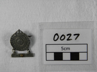
Badge, Angus and Coote, To The Woman of Australia Badge, 1942
... 'TO THE WOMAN OF AUSTRALIA'. Map of Australia in centre of wreath. ...Authority for the issue of the badge in the Second World War was issued under AIF Order 200 dated 14 February 1941. world war two royal australian air force australian imperial force australian army nursing service 'TO THE WOMAN OF AUSTRALIA'. Map of Australia in centre of wreath. ...In the Second World War there was only one badge issued to the nearest female relative of members of the RAN, the Australian Imperial Force (including members of the Australian Army Nursing Service), and the Royal Australian Air Force on active service abroad. Stars displayed on a bar suspended below the badge represented the number of relatives involved in the war effort. Authority for the issue of the badge in the Second World War was issued under AIF Order 200 dated 14 February 1941.Metal badge with crown on top & bar underneath with 1 star.'TO THE WOMAN OF AUSTRALIA'. Map of Australia in centre of wreath. On reverse side issued by the Commonwealth Government. No 'A100853' world war two, royal australian air force, australian imperial force, australian army nursing service -
 Mont De Lancey
Paper Cup
... Set of four paper cups - white, red and blue with Athletes, flags and Australian map....Commemorating 1956 Melbourne Olympic Games cups disposable cups Set of four paper cups - white, red and blue with Athletes, flags and Australian map. Paper Cup ...Commemorating 1956 Melbourne Olympic GamesSet of four paper cups - white, red and blue with Athletes, flags and Australian map.cups, disposable cups -
Emerald Museum & Nobelius Heritage Park
Book - Book of maps, Shell Company of Australia Ltd, Shell Motor Tours Victoria, 1920s or 1930s
... Australia...tourism...maps...Emerald Victoria Australia tourism maps Shell Company of Australia Ltd. ...Tours prepared in conjunction with Broadbent 'Fifty Miles Round Melbourne' (see VEMU1140). See Tour No. 14, page 45, for tour including Emerald.Soft cover book with maps and black and white photographs. Brown cover with red printing. Staples removed.emerald, victoria, australia, tourism, maps, shell company of australia ltd. -
Emerald Museum & Nobelius Heritage Park
Flyer - Real Estate Flyer, Mahony, John T. et al
... Australia...Subdivisions...maps...Emerald Victoria Australia Subdivisions maps plans real estate agencies guest houses Brookdale House John T. ...Brookdale Estate was selected in 1870 by Charman. The family built a small home where several of their children were born. About 1905 they built a larger guest house where they entertained people who travelled on the train. After the deaths of Mr and Mrs Charman, J. Mahony subdivided the land, except for three blocks that had been acquired by family members. Brookdale House was destroyed by fire about 1925.A real estate flyer, advertising first subdivision of Brookdale Estate, auction of Brookdale House 31st January 1921, 170 blocks from half to four acres.emerald, victoria, australia, subdivisions, maps, plans, real estate agencies, guest houses, brookdale house, john t. mahony, charman family -
Emerald Museum & Nobelius Heritage Park
Map - Tourist Map, Lands Department Melbourne, Photocopy 26/5/1926
... Australia...tourism...maps...Map of Dandenong Ranges, Ferntree Gully to Gembrook. Shows walking tracks, railway, guest houses, picnic grounds, hotels etc. Dandenong Ranges Victoria Australia ...Map of Dandenong Ranges, Ferntree Gully to Gembrook. Shows walking tracks, railway, guest houses, picnic grounds, hotels etc.Tourist map of Dandenong Ranges, Ferntree Gully and Gembrook district - paper on cloth.T298dandenong ranges, victoria, australia, tourism, maps, guest houses
