Showing 9 items matching "ballaarat flat"
-
 Federation University Historical Collection
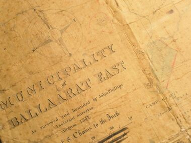
Map, Municipality of Ballarat East, 1857
... ...ballaarat flat...The map has read and blue highlights, and identifies areas such as Mount Pleasant, Golden Point, White Flat, Nightingale, Malekoff, Old Post Office Hill, Red streak, Gumtree Flat, Old Gravelpits, Bakery Hill, Ballaarat Flat, The Camp, Specimen Gully, Pennyweight Hill, Warrenheip Gully, Gays Gully, Pennyweight Flat, Eureka, Black Hill, Pinchgut, Crocodile, Hit or Miss, Little Bendigo, Brown Hill, Mopoke, Cricket Reserve, Canadian Hotel, Ballarat East...The map has read and blue highlights, and identifies areas such as Mount Pleasant, Golden Point, White Flat, Nightingale, Malekoff, Old Post Office Hill, Red streak, Gumtree Flat, Old Gravelpits, Bakery Hill, Ballaarat Flat, The Camp, Specimen Gully, Pennyweight Hill, Warrenheip Gully, Gays Gully, Pennyweight Flat, Eureka, Black Hill, Pinchgut, Crocodile, Hit or Miss, Little Bendigo, Brown Hill, Mopoke, Cricket Reserve, Canadian Hotel, Ballarat East Municipality of Ballarat East, 1857 Map Map ...Gold was discovered in Ballarat in 1851. This plan was created six years later and names some of the great gold locations of Ballarat East. It also shows the locality of the Eureka Stockade (1854) and the walking tracks and roads on the Ballarat East Goldfield.In 2007 this map was listed on the inaugural Ballarat Treasure's Register.Large map backed onto linen. The map has read and blue highlights, and identifies areas such as Mount Pleasant, Golden Point, White Flat, Nightingale, Malekoff, Old Post Office Hill, Red streak, Gumtree Flat, Old Gravelpits, Bakery Hill, Ballaarat Flat, The Camp, Specimen Gully, Pennyweight Hill, Warrenheip Gully, Gays Gully, Pennyweight Flat, Eureka, Black Hill, Pinchgut, Crocodile, Hit or Miss, Little Bendigo, Brown Hill, Mopoke, Cricket Reserve, Canadian Hotel, Ballarat Eastmount pleasant, golden point, white flat, nightingale, malekoff, old post office hill, red streak, gumtree flat, old gravelpits, bakery hill, ballaarat flat, the camp, specimen gully, pennyweight hill, warrenheip gully, gays gully, pennyweight flat, eureka, black hill, pinchgut, crocodile, hit or miss, little bendigo, brown hill, mopoke, cricket reserve, canadian hotel, ballarat eastm phillips, john phillips, field draughtsman, ballarat east, ballarat east map -
 Ballarat Tramway Museum
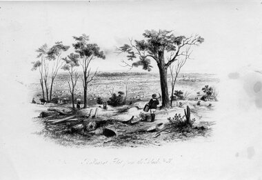
Photograph - Black & White Photograph/s
... Black and white photographic copy print of a drawing showing the Ballarat district from Black Hill in the early mining days of the town. Titled "Ballaarat flat from the Black Hill". Has black mark in top right hand corner and a number of water stains on both sides of the print. ...Black and white photographic copy print of a drawing showing the Ballarat district from Black Hill in the early mining days of the town. Titled "Ballaarat flat from the Black Hill". Has black mark in top right hand corner and a number of water stains on both sides of the print. ...Black and white photographic copy print of a drawing showing the Ballarat district from Black Hill in the early mining days of the town. Titled "Ballaarat flat from the Black Hill". Has black mark in top right hand corner and a number of water stains on both sides of the print. Has ARHS Vic Div. photo no. stamp on rear, but this has been crossed out.In pencil in the middle of the photo "Dr Andrews" and "ARHS (Vic. Div.) Archives" photo stamp in the bottom right hand corner, in red ink.trams, tramways, ballarat, black hill, mining -
 Federation University Historical Collection
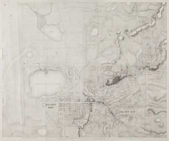
Map, Ballaarat Gold Field, 1861, 1861
... flat...poverty hill...chinese village...robert brough smyth...Ballarat map 1861...Ballaarat...In November 2004 the Central Highlands Regional Library presented a special edition of 200 copies of the 1861 map reproduced from a copy in their collection. ballarat map ballarat east lake wendouree survey mines robert davidson ballarat gold field 1861 yuille's swamp wendouree swamp little bendigo diggings gold leads old post office hill specimen hill bakery hill black hill dead horse creek brown hill pennyweight hill clayton hill soldiers hill golden point gum tree flat white flat poverty hill chinese village robert brough smyth Ballarat map 1861 Ballaarat Vineyard Dead Horse Gully Deadhorse Creek Invermay Black Hill Flat Gaelic Church Police Reserve Magpie Range Dalton's Flat Caadian Lead Rifle Butts Powder Magazine Bathing House Government Camp Gold Office Chinese Llanberrris Victoria Theatre Charlie Napier Hotel United States Hotel Grape's Hoel Clayton's Hill Cattleyard Hill Free Trade Hotel Esmond Lead Bakery Hill Black Hill Lead Juvenile Reformatory Ballarat Orphanage Lady Barkly Lead Triffet's Slaughter Yard Little Bendigo Melbourne Road T. ...A party of surveyors camped by Yuille's Swamp (later Lake Wendouree) and surveyed the countryside for a map to be produced by the Geological Survey of Victoria. In November 2004 the Central Highlands Regional Library presented a special edition of 200 copies of the 1861 map reproduced from a copy in their collection. Original 1861 map of Ballarat showing streets and leads. Blue dots indicate gold leads, and red lines indicate auriferous quartz reef and outcrops of quartz veins."Compiled & Drawn from the Survey of Mining Surveyors Davidson, Fitzpatrick and Cowan & the Plans in the Surveyor General's Office by J. Brahe, 21st October 1861. R. Brough Smyth, Secretary for Mines. The Honourable J.B. Humffray, M.L.A. Commr of Mines.”ballarat, map, ballarat east, lake wendouree, survey, mines, robert davidson, ballarat gold field 1861, yuille's swamp, wendouree swamp, little bendigo diggings, gold leads, old post office hill, specimen hill, bakery hill, black hill, dead horse creek, brown hill, pennyweight hill, clayton hill, soldiers hill, golden point, gum tree flat, white flat, poverty hill, chinese village, robert brough smyth, ballarat map 1861, ballaarat vineyard, dead horse gully, deadhorse creek, invermay, black hill flat, gaelic church, police reserve, magpie range, dalton's flat, caadian lead, rifle butts, powder magazine, bathing house, government camp, gold office, chinese, llanberrris, victoria theatre, charlie napier hotel, united states hotel, grape's hoel, clayton's hill, cattleyard hill, free trade hotel, esmond lead, bakery hill, black hill lead, juvenile reformatory, ballarat orphanage, lady barkly lead, triffet's slaughter yard, little bendigo, melbourne road, t. cowan, thomas cowan -
 Federation University Historical Collection
Map, Ballaarat Gold Field, 1861, 21/10/1861
... flat...yarrowee...yarrowee creek...brache...j. brache...survey...ballaarat...In November 2004 the Central Highlands Regional Library presented a special edition of 200 copies of the 1861 map reproduced from a copy in their collection. ballarat map davidson robert brough-smyth fitzpatrick cowan yuille's swamp public garden reserve manure depot black hill ballarat east old post office hill pennyweight hill claytons hill golden point mining railway cricket ground swamp creek cemetery sludge reserve bakery hill gaelic church juvenile reformatory orphanage specimen hill eureka lead cattle yard hill dalton's flat chinese village poverty hill railway reserve little bendigo diggings pound reserve allied armies flour mill agricultural reserve marsh survey reserve survey corps white flat yarrowee yarrowee creek brache j. brache survey ballaarat gold field 1861 Compiled & Drawn from the Survey of Mining Surveyors Davidson, Fitzpatrick and Cowan & the Plans in the Surveyor General's Office by J. ...A party of surveyors camped by Yuille's Swamp (later Lake Wendouree) and surveyed the countryside for a map to be produced by the Geological Survey of Victoria. In November 2004 the Central Highlands Regional Library presented a special edition of 200 copies of the 1861 map reproduced from a copy in their collection. Original geological map of Ballarat showing property, waterways, mines, churches, schools, water races, and garden reserves. It was compiled and drawn from the surveys of Mining Surveyors Davidson, Fitzpatrick and Cowan.Compiled & Drawn from the Survey of Mining Surveyors Davidson, Fitzpatrick and Cowan & the Plans in the Surveyor General's Office by J. Brahe, 21st October 1861. R. Brough Smyth, Secretary for Mines. The Honourable J.B. Humffray, M.L.A. Commr of Mines.ballarat, map, davidson, robert brough-smyth, fitzpatrick, cowan, yuille's swamp, public garden reserve, manure depot, black hill, ballarat east, old post office hill, pennyweight hill, claytons hill, golden point, mining, railway, cricket ground, swamp creek, cemetery, sludge reserve, bakery hill, gaelic church, juvenile reformatory, orphanage, specimen hill, eureka lead, cattle yard hill, dalton's flat, chinese village, poverty hill, railway reserve, little bendigo diggings, pound reserve, allied armies, flour mill, agricultural reserve, marsh, survey reserve, survey corps, white flat, yarrowee, yarrowee creek, brache, j. brache, survey, ballaarat gold field 1861 -
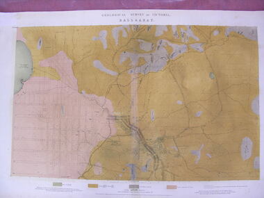 Federation University Historical Collection
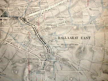
Map - Geological Survey, J. Phillips, Geological Survey of Victoria - Ballarat, 1857, 10/1858
... Ballaarat Cemetery...Bakery Hill...Specimen Hill...Soldiers Hill...Nightingale Lead...native youth black hill flat...Barker Library (top floor) Mount Helen goldfields ballarat geological geology Geological plan Main Road Camp Golden Point Pennyweight Hill Clayton Hill Ballaarat Cemetery Bakery Hill Specimen Hill Soldiers Hill Nightingale Lead native youth black hill flat White flat mining mines Eureka Lead Old Post Office Hill Geological map of the Ballarat District featuring four colours. ...Geological map of the Ballarat District featuring four colours.ballarat, geological, geology, geological plan, main road, camp, golden point, pennyweight hill, clayton hill, ballaarat cemetery, bakery hill, specimen hill, soldiers hill, nightingale lead, native youth black hill flat, white flat, mining, mines, eureka lead, old post office hill -
 Federation University Historical Collection
Book, Historic Sites Survey: North Central Study Area, 1979, 1979
... flat...mcintyre...rheola...diamond hill...fosterville...coliban water works...green gully...newstead...muckleford forest...costerfield...graytown...bailieston...waranga irrigaiton system...eucalyptus distillery...mia mia bridge...korokubeal township researce...concegella slate quarry...chewton...fryerstown...kingower...timor...talbot...majorca...carisbroook...clunes...st arnaud...taradale...icomos...dunolly...limestone...castlemaine slate quarry...harcourt granite...taradale railway viaduct...loddon united waterworks trust...gouldburn weir...carisbrook lock-up...history of tree planting in streets...history of public reserves...r.u. nicholls nurseryman...thomas lang...francis moss...ballarat botanical gardens...ballarat school of mines botanical gardens...lake wendouree...victoria park, ballarat...muont holled smith...ballaarat...Barker Library (top floor) Mount Helen goldfields The North Central Study Area included the Shires of Avoca, Bet Bet, east Loddon, Goulburn, Untly, Kara Kara, Korong, Maldon, Marong, Metcalfe, McIvor, Newstead, Strathfieldsaye, Stawell, Talbot, Clunes, Tullaroop and Waranga. castlemaine mount alexander goldfield maldon percydale warrenmang moliagul tarnagulla stuart mill the whipstick whroo rushworth graytown ironbark forest st arnoaud new bendigo landsborough inglewood kurting wedderburn wehla kooroora langham flat mcintyre rheola diamond hill fosterville coliban water works green gully newstead muckleford forest costerfield graytown bailieston waranga irrigaiton system eucalyptus distillery mia mia bridge korokubeal township researce concegella slate quarry chewton fryerstown kingower timor talbot majorca carisbroook clunes st arnaud taradale icomos dunolly limestone castlemaine slate quarry harcourt granite taradale railway viaduct loddon united waterworks trust gouldburn weir carisbrook lock-up history of tree planting in streets history of public reserves r.u. nicholls nurseryman thomas lang francis moss ballarat botanical gardens ballarat school of mines botanical gardens lake wendouree victoria park, ballarat muont holled smith ballaarat old cemetery planting eastern oval ballarat east botanical gardens ballarat east town hall gardens eureka stockade reserve ballarat observatory plantings yarrowee creek plantings yarrowee bluestone channels ballarat woollen mill band and albion mullock heap black hill plantings yarrowee creek channels canadian creek channel specimen vale channel poverty point reserve union jack reserve buninyong imperial mine, buninyong victoria street plantings bridge mall sturt street gardens ballarat avenue of honour plantings white flat oval plantings camp street elms burnt creek 153 page book with white plastic binding. ...The North Central Study Area included the Shires of Avoca, Bet Bet, east Loddon, Goulburn, Untly, Kara Kara, Korong, Maldon, Marong, Metcalfe, McIvor, Newstead, Strathfieldsaye, Stawell, Talbot, Clunes, Tullaroop and Waranga. 153 page book with white plastic binding. It is an historic sites survey for the North Central Study Area commissioned by the Land Conservation Council, the Ministry for COnservation and the Australian Heritage Commission. castlemaine, mount alexander goldfield, maldon, percydale, warrenmang, moliagul, tarnagulla, stuart mill, the whipstick, whroo, rushworth, graytown ironbark forest, st arnoaud, new bendigo, landsborough, inglewood, kurting, wedderburn, wehla, kooroora, langham flat, mcintyre, rheola, diamond hill, fosterville, coliban water works, green gully, newstead, muckleford forest, costerfield, graytown, bailieston, waranga irrigaiton system, eucalyptus distillery, mia mia bridge, korokubeal township researce, concegella slate quarry, chewton, fryerstown, kingower, timor, talbot, majorca, carisbroook, clunes, st arnaud, taradale, icomos, dunolly, limestone, castlemaine slate quarry, harcourt granite, taradale railway viaduct, loddon united waterworks trust, gouldburn weir, carisbrook lock-up, history of tree planting in streets, history of public reserves, r.u. nicholls nurseryman, thomas lang, francis moss, ballarat botanical gardens, ballarat school of mines botanical gardens, lake wendouree, victoria park, ballarat, muont holled smith, ballaarat old cemetery planting, eastern oval, ballarat east botanical gardens, ballarat east town hall gardens, eureka stockade reserve, ballarat observatory plantings, yarrowee creek plantings, yarrowee bluestone channels, ballarat woollen mill, band and albion mullock heap, black hill plantings, yarrowee creek channels, canadian creek channel, specimen vale channel, poverty point reserve, union jack reserve buninyong, imperial mine, buninyong, victoria street plantings, bridge mall, sturt street gardens, ballarat avenue of honour plantings, white flat oval plantings, camp street, elms, burnt creek -
 Federation University Historical Collection
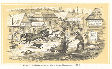
Print - Images, Unbound Images from Withers' 'History of Ballarat', c1987
... ballaarat old cemetery...mining registrar's office...reward posters...lake wendouree...bakery hill...madame berry gold mining company...ballarat from bath's hotel...quartz crushing...black hill...horse puddler...pennyweight flat...Barker Library (top floor) Mount Helen goldfields mail coach eureka graves ballaarat old cemetery mining registrar's office reward posters lake wendouree bakery hill madame berry gold mining company ballarat from bath's hotel quartz crushing black hill horse puddler pennyweight flat aborigines creswick withers william b. withers history of ballarat Copies of all images from the 1887 version of Withers' 'History of Ballarat'. ...Copies of all images from the 1887 version of Withers' 'History of Ballarat'. The images include copies of the Eureka Stockade reward posters. mail coach, eureka graves, ballaarat old cemetery, mining registrar's office, reward posters, lake wendouree, bakery hill, madame berry gold mining company, ballarat from bath's hotel, quartz crushing, black hill, horse puddler, pennyweight flat, aborigines, creswick, withers, william b. withers, history of ballarat -
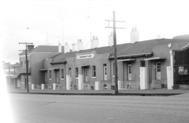 Ballaarat Mechanics' Institute (BMI Ballarat)
Centenary Flats Mair St
... Ballaarat Mechanics' Institute (BMI Ballarat) 117 Sturt St Ballarat goldfields This photograph is from the Max Harris Collection held by the Ballaraat Mechanics' Institute. Please contact BMI for all print and usage inquiries. Ballarat Centenary Flats ...This photograph is from the Max Harris Collection held by the Ballaraat Mechanics' Institute. Please contact BMI for all print and usage inquiries.ballarat, centenary, flats, mair st -
Unions Ballarat
Panoramas of Ballaarat, 1997
... ballaarat...ballarat...photographs...history...buildings/structures...lithographs...lake wendouree...ballarat flat...Pictorial expression of Ballarat's history. btlc ballarat trades and labour council ballarat trades hall ballaarat ballarat photographs history buildings/structures lithographs lake wendouree ballarat flat panoramas ballarat historical society Paper; part leather bound; book. ...A historical timeline of Ballarat images (1853 to 1998).Pictorial expression of Ballarat's history.Paper; part leather bound; book.btlc, ballarat trades and labour council, ballarat trades hall, ballaarat, ballarat, photographs, history, buildings/structures, lithographs, lake wendouree, ballarat flat, panoramas, ballarat historical society