Showing 132 items matching "barbers road"
-
 Mt Dandenong & District Historical Society Inc.
Photograph, View From Corner of Doughty's Road and Barbers Road 1913
... View From Corner of Doughty's Road and Barbers Road 1913......Barbers Road...Taken c1913, this photograph gives a clear indication of where significant buildings were located in relation to one another. Barbers Road is running through the picture with the guest house 'Kia-Ora' , built by George Barber in the centre. ...View from corner of Doughty’s and Barbers Road 1913. “Kia Ora” in centre Paynter’s “Iona” near center skyline above “Kia Ora” with “Kalorama” on its right and Peter’s hut of the time below it among orchard trees. ...Kia-Ora Iona Kalorama Mountjoy guesthouse Guest House Barbers Road Doughty's Road Paynter Jeeves George Barber View from corner of Doughty’s and Barbers Road 1913. ...John Lundy-Clarke grew up in the Kalorama/Mt Dandenong area and later in life (1972-74) began to write a comprehensive history of the area working from an original settlement map in an effort to cover all areas. Taken c1913, this photograph gives a clear indication of where significant buildings were located in relation to one another. Barbers Road is running through the picture with the guest house 'Kia-Ora' , built by George Barber in the centre. High on the skyline on the left is the 'Mountjoy' guesthouse, indicating the location of The Gap, or FiveWays. The small 'boxy' house above 'Kia-Ora' is 'Iona' built by the Paynter family who also built 'Mountjoy'. The Jeeves property 'Kalorama' is to the right of 'Iona' and this is the area you now look to from the FiveWays Lookout. The man in the photo is wearing a trilby hat so is probably a Rose Series employee - a feature in many Rose Series postcards.Black and white photograph that is a copy of Rose Series Postcard # 156. A man can be seen walking down an unmade road with haystacks to his right. Buildings and crops can be seen on the hillsides. Handwritten inscription on reverse by John Lundy-ClarkeView from corner of Doughty’s and Barbers Road 1913. “Kia Ora” in centre Paynter’s “Iona” near center skyline above “Kia Ora” with “Kalorama” on its right and Peter’s hut of the time below it among orchard trees. “Mountjoy” is on left skyline. W. Haye’s home is centre left. Hay paddock is Barbers Lot 25 Village Settlement.kia-ora, iona, kalorama, mountjoy, guesthouse, guest house, barbers road, doughty's road, paynter, jeeves, george barber -
 Mt Dandenong & District Historical Society Inc.
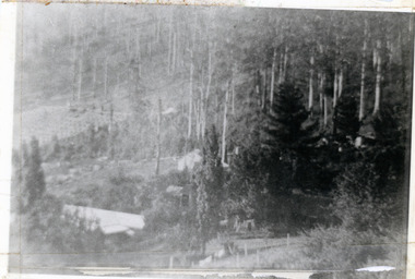
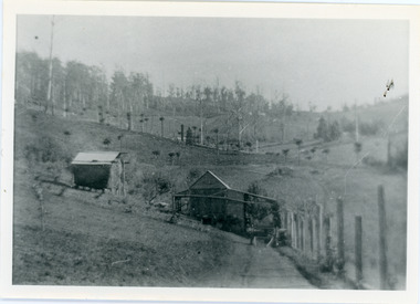
Photograph, 1913 View Over Logan's House in Village Settlement, 1913
... ...Barbers Road...Photograph taken in 1913 from Barbers Road showing the view down the valley. ...1913 view over Logan’s house on Village Settlement Lot 28 taken from Barber’s Road. This is the house that the runaway log leaped over in 1930 to land far down the orchard row beyond the house. ...Farndons Community Hall 42 Falls Road Mt Dandenong yarra-valley-and-the-dandenong-ranges Logan Bob Logan Robert Logan Barbers Road Shiloah Child Richardson Link Road 1913 view over Logan’s house on Village Settlement Lot 28 taken from Barber’s Road. ...Photograph taken in 1913 from Barbers Road showing the view down the valley. Roof in foreground is house on Bob Logan's Lot 28 in the Village Settlement. This photograph has a detailed inscription on the back handwritten by John Lundy-Clarke in 1974.1913 view over Logan’s house on Village Settlement Lot 28 taken from Barber’s Road. This is the house that the runaway log leaped over in 1930 to land far down the orchard row beyond the house. “Shiloah” is centre partly behind the clump of trees and the paddocks of Child and Richardsons pioneer selections are in the background. Link Road is centre right.logan, bob logan, robert logan, barbers road, shiloah, child, richardson, link road -
 Mt Dandenong & District Historical Society Inc.
Photograph, Kalorama Gap in 1927, 1927
... ...barbers road...CRB Main Road, Ridge Road, Old Coach Road and barber's Road also visible. This photograph has a detailed inscription on the back handwritten by John Lundy-Clarke in 1974. ...Showing Jeeves Garage Fiveways Cafe Nicholls Store 'Mountjoy' C.R.B Main Rd Center Ridge Road Right of Center Old Coach Road lower right corner behind shed Barber's Road going left through clump of trees in center ...Farndons Community Hall 42 Falls Road Mt Dandenong yarra-valley-and-the-dandenong-ranges kalorama gap kalorama fiveways fiveways cafe jeeves jeeves garage garage nicholls store mountjoy barbers road old coach road ridge road main road crb road The Kalorama Gap in 1927. ...View of the Kalorama Gap (FiveWays) in 1927. Buildings shown are Jeeves' Garage, FiveWays Cafe, Nicholl's Store, Mountjoy. CRB Main Road, Ridge Road, Old Coach Road and barber's Road also visible. This photograph has a detailed inscription on the back handwritten by John Lundy-Clarke in 1974. The Kalorama Gap in 1927. Showing Jeeves Garage Fiveways Cafe Nicholls Store 'Mountjoy' C.R.B Main Rd Center Ridge Road Right of Center Old Coach Road lower right corner behind shed Barber's Road going left through clump of trees in center kalorama gap, kalorama, fiveways, fiveways cafe, jeeves, jeeves garage, garage, nicholls store, mountjoy, barbers road, old coach road, ridge road, main road, crb road -
 Mt Dandenong & District Historical Society Inc.
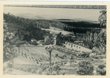
Photograph, The Valley of the Harmony Vale Settlement c1910, 1973
... ...Barbers Road...Scene looking across the valley of Harmony Vale from Barbers Road. c1910. Photograph copied by John Lundy-Clarke in 1973. ...The valley of the Harmony Vale settlement on the Olinda Creek from Barbers Road. "Shiloah" on far left centre. John William Richardson's home among trees left of centre. ...Farndons Community Hall 42 Falls Road Mt Dandenong yarra-valley-and-the-dandenong-ranges Kalorama Harmony Vale Olinda Creek Barbers Road Shiloah sawmill Child Bert Child Glenrivers The valley of the Harmony Vale settlement on the Olinda Creek from Barbers Road. ...Scene looking across the valley of Harmony Vale from Barbers Road. c1910. Photograph copied by John Lundy-Clarke in 1973. This photograph has a detailed inscription on the back handwritten by John Lundy-Clarke in 1974.The valley of the Harmony Vale settlement on the Olinda Creek from Barbers Road. "Shiloah" on far left centre. John William Richardson's home among trees left of centre. Homestead Harmony Vale above log yard (see below) and among orchard trees. Child Bros sawmill and log yard with logs among trees above flat cultivation right of centre. Bert Childs home beyond "Harmony Vale". Lucas' "Glenrivers" is in gully above main clearing centre top left. Frank Childs home among trees centre of picture. Taken about 1910 by Rose Series. Copied 1974 JLC.kalorama, harmony vale, olinda creek, barbers road, shiloah, sawmill, child, bert child, glenrivers -
 Mt Dandenong & District Historical Society Inc.
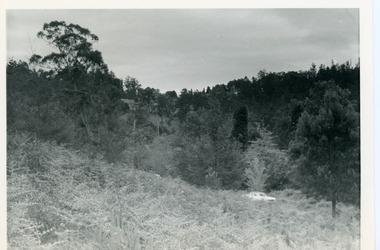
Photograph, View Up Valley Towards Kalorama Gap 1973
... ...Barbers Road...White car is on Barbers Road and site of “Kia Ora” is to right of it....Kalorama Kalorama Gap Five Ways Barbers Road George Barber Kia-Ora 1973 View up Valley towards Kalorama Gap from what was Crooks LOT 24. ...John Lundy-Clarke grew up in the Kalorama/Mt Dandenong area and later in life (1972-74) began to write a comprehensive history of the area working from an original settlement map in an effort to cover all areas. This photograph would have been taken to show the changes in the area over the years. Kalorama Gap is now called Five Ways. 'Kia-Ora ' was a guest house built by George Barber. It is no longer standing.Black and white photograph showing a bush scene with a white car visible on the right. Handwritten inscription on reverse by John Lundy-Clarke1973 View up Valley towards Kalorama Gap from what was Crooks LOT 24. White car is on Barbers Road and site of “Kia Ora” is to right of it.kalorama, kalorama gap, five ways, barbers road, george barber, kia-ora -
 Mt Dandenong & District Historical Society Inc.
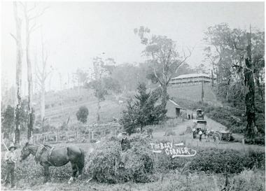
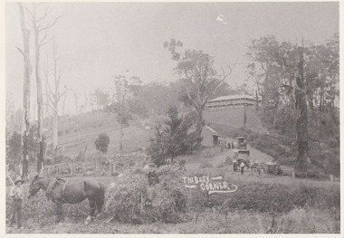
Photograph, 'The Busy Corner' FiveWays c1909, c1909
... ...Barbers Road...Landscape view of Ridge and Barbers Roads showing Mountjoy Guest House on crest, Mt Dandenong North Post Office, three delivery carts and people. ...Farndons Community Hall 42 Falls Road Mt Dandenong yarra-valley-and-the-dandenong-ranges Mountjoy Ridge Road FiveWays Barbers Road Frederick Jeeves Mt Dandenong North Post Office Theo Hand Landscape view of Ridge and Barbers Roads showing Mountjoy Guest House on crest, Mt Dandenong North Post Office, three delivery carts and people. ...Landscape view of Ridge and Barbers Roads showing Mountjoy Guest House on crest, Mt Dandenong North Post Office, three delivery carts and people. Lower LH corner Fred Jeeves (standing), Theo Hand (on wagon) and Blossom (horse).mountjoy, ridge road, fiveways, barbers road, frederick jeeves, mt dandenong north, post office, theo hand -
 Mt Dandenong & District Historical Society Inc.
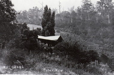
Photograph, Kalorama Guest-house - Front View
... ...Barbers Road...Looking down on Kalorama Guest-house from Barbers Road. Property of Ellis and Eliza Jeeves before moving to Mountjoy...Farndons Community Hall 42 Falls Road Mt Dandenong yarra-valley-and-the-dandenong-ranges Looking down on Kalorama Guest-house from Barbers Road. Property of Ellis and Eliza Jeeves before moving to Mountjoy Ellis Jeeves Jeeves Guest House Kalorama Guest-house Barbers Road KALORAMA Mt Dandenong. ...Looking down on Kalorama Guest-house from Barbers Road. Property of Ellis and Eliza Jeeves before moving to MountjoyBlack and white photograph with house in foreground and a cleared block and forest in background.KALORAMA Mt Dandenong. FRONT VIEWellis jeeves, jeeves, guest house, kalorama guest-house, barbers road -
 Mt Dandenong & District Historical Society Inc.
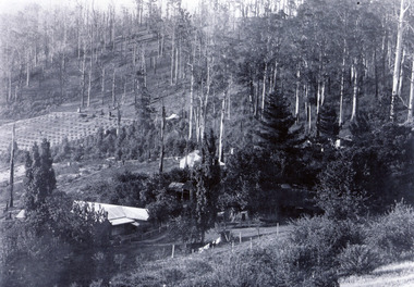
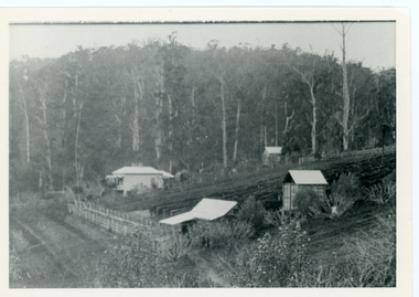
Photograph, Kalorama Guest-house with View of Valley
... Barbers Road...Roof of Kalorama Guest-house, owned by Ellis and Eliza Jeeves, in foreground with two other houses, forest and cleared section. Taken from Barbers Road. ...Roof of Kalorama Guest-house, owned by Ellis and Eliza Jeeves, in foreground with two other houses, forest and cleared section. Taken from Barbers Road. Barbers Road Guest House Kalorama Guest-house Black and white photograph with four buildings visible, cleared crop areas and sparse forest. ...Looking acoss Kalorama Valley. Roof of Kalorama Guest-house, owned by Ellis and Eliza Jeeves, in foreground with two other houses, forest and cleared section. Taken from Barbers Road. Black and white photograph with four buildings visible, cleared crop areas and sparse forest. Washing hangs on a line in the foreground.barbers road, guest house, kalorama guest-house -
 Mt Dandenong & District Historical Society Inc.
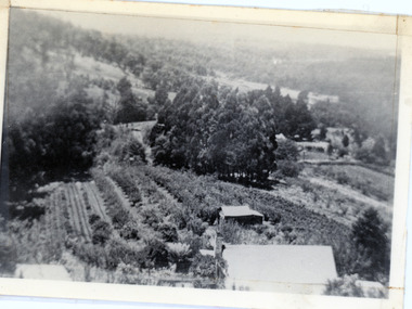
Photograph, Harmony Vale, c1913
... ...Barbers Road...View of Harmony Vale, the original Kalorama settlement taken from Barbers Road. Child's sawmill can be seen (centre) with the log yard to the right. ...Harmony Vale harmony vale Child's sawmill sawmill Barbers Road Richardson Shiloah Rose Series Photo of Harmony Vale on the Olinda Creek taken from Logans Lot 28. ...View of Harmony Vale, the original Kalorama settlement taken from Barbers Road. Child's sawmill can be seen (centre) with the log yard to the right. Richardson's home "Harmony Vale' is in the orchard above the logs.Black and white photograph copied from a Rose Series postcard showing the area known as "Harmony Vale' - the original Kalorama settlement. Child's sawmill is in the centre.Rose Series Photo of Harmony Vale on the Olinda Creek taken from Logans Lot 28. Link Rd crossing centre Shiloah complex left centre. Richardsons (Jeannie’s) “Mt Calvin” between trees above tree fern. Isaac Jeeves house with the tree fern floor among trees against forest right centre. Mill yard with logs above cultivated flat. Mill to left. “Harmony Vale” homestead among orchard above logs. “Glenrivers” in gully at top of clearing. About 1913. Copied JLC 1973harmony vale, harmony vale, child's sawmill, sawmill, barbers road, richardson, shiloah -
 Mt Dandenong & District Historical Society Inc.
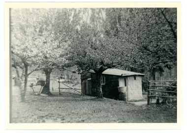
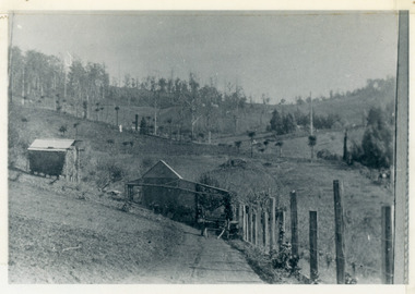
Photograph
... ...barbers road...Merci on the settlement map, having selected Lot 26 in the Village Settlement in 1901.It was a 5 acre Lot bordering Barbers Road and the Dray Track (now Link Road). ...Merci on the settlement map, having selected Lot 26 in the Village Settlement in 1901.It was a 5 acre Lot bordering Barbers Road and the Dray Track (now Link Road). ...French Louis Merci is shown as J.L. Merci on the settlement map, having selected Lot 26 in the Village Settlement in 1901.It was a 5 acre Lot bordering Barbers Road and the Dray Track (now Link Road). Louis shared his hut for some time with Peter the Swede. When Louis became ill with cancer and could no longer work he sold his property to George Barber in return for a weekly payment.Black and white photograph of hut in row of blossoming trees.french louis, louis merci, j l merci, peter the swede, george barber, link road, barbers road, hut, dray track -
 Mt Dandenong & District Historical Society Inc.
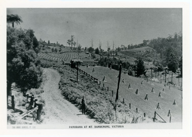
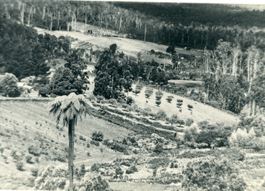
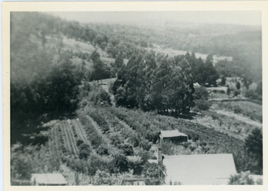
Photograph, View Over Logan's From Barber's Road
... ...Barbers Road...This photograph was taken c1920 and shows the view over Logan's property of Harmony Vale, taken from Barber's Road....View Over Logan's From Barber's Road. Photograph Photograph ...Robert Logan selected Lot 28 of the Village Settlement in 1896 and lived there until his death in 1936. Historian John Lundy-Clarke tells how Logan planted his land with plums, peaches and apples and also grew raspberries, beans, cabbages and lettuces. He also planted a small patch of oats that he harvested to feed his horse. This photograph was taken c1920 and shows the view over Logan's property of Harmony Vale, taken from Barber's Road.Black and white photograph showing lines of crops and orchard trees with rooftops in foreground and larger trees and cleared areas in background.robert logan, logan, orchard, crops, raspberries, harmony vale, barbers road -
 Mt Dandenong & District Historical Society Inc.
Photograph, View Up Valley At Kalorama
... ...Barbers Road...The building in the centre of the photograph is 'Kia-Ora' guest house. Situated on Barber’s Road, ‘Kia-Ora’ was built in 1912 by George Barber. ...Kalorama Kalorama Valley John Lundy-Clarke Barbers Road George Barber Kia-Ora guest house Iona View up valley at Kalorama from near junction of Barbers and Doughty’s Rds. ...John Lundy-Clarke grew up in the Kalorama/Mt Dandenong area and later in life (1972-74) began to write a comprehensive history of the area working from an original settlement map in an effort to cover all areas. The building in the centre of the photograph is 'Kia-Ora' guest house. Situated on Barber’s Road, ‘Kia-Ora’ was built in 1912 by George Barber. It was later leased by a Mrs Pemberthy. “Kia-Ora’ was one of four places connected when the telephone was brought into the district in 1912. The other places were ‘Mountjoy’, ‘Cherry Farm’ and ‘Callum House’. ‘Kia-Ora’ was burnt down in 1924. Black and White copy of section of a Rose Series postcard. Shows view up the valley at Kalorama with a decorative building centre middle of photograph. Handwritten description by John Lundy-Clarke on reverse.View up valley at Kalorama from near junction of Barbers and Doughty’s Rds. “Kia Ora” guest house in centre. Paynter’s “Iona” top left with “Kalorama” to its right. About 1912. Rose Series copied by JLC 1973.kalorama, kalorama valley, john lundy-clarke, barbers road, george barber, kia-ora, guest house, iona -
 Mt Dandenong & District Historical Society Inc.
Photograph, View of valley looking south over 'Kalorama' towards falls, 1908
... ...Barbers Road...Faintly below line of Barber’s Road above “Kalorama” is Logan’s house on Lot 28. ...Faintly below line of Barber’s Road above “Kalorama” is Logan’s house on Lot 28. ...View taken 1908 looking south over 'Kalorama', home of Ellis and Eliza Jeeves, across the valley towards the falls.This photograph has a detailed inscription on the back handwritten by John Lundy-Clarke in 1974.View taken 1908 of valley looking south over “Kalorama” towards the falls. House right of “Kalorama” was Paynter’s “Iona” on Lot 29. Faintly below line of Barber’s Road above “Kalorama” is Logan’s house on Lot 28. House against orchard was Pimm’s later Prince’s Lot 19. Big trees on right were on Price’s Lot 18 and were between Tosari Rd and Rosemont Cres. It was FROM one of these being cut up in 1931 that the round length log weighing ½ a ton got away from the splitters and raced down the hill in bounces, one of which cleared Barber’s Rd and Logan’s house in leaping from the fence line above the road.kalorama, paynter, iona, barbers road, ellis jeeves -
 Mt Dandenong & District Historical Society Inc.
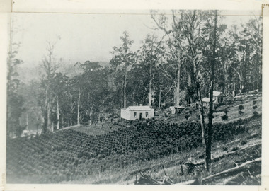
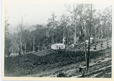
Photograph, George Barber's Home Forest Edge after 1912 Looking South West, c1912
... barber...kalorama...barber's road...George Barber built a homestead later named Forest Edge on Barber's Road and lived there with his wife Sarah Ann (nee Richardson)....George Barber's home on bend of Barber's Road on Lot 25, Village Settlement. Showing passionfruit plantation. ...Farndons Community Hall 42 Falls Road Mt Dandenong yarra-valley-and-the-dandenong-ranges George Barber built a homestead later named Forest Edge on Barber's Road and lived there with his wife Sarah Ann (nee Richardson). forest edge george barber sarah ann barber kalorama barber's road George Barber's home on bend of Barber's Road on Lot 25, Village Settlement. ...George Barber built a homestead later named Forest Edge on Barber's Road and lived there with his wife Sarah Ann (nee Richardson).Black and white photograph showing the side view of a house and three outbuildings. Reverse of photograph has handwritten description by John Lundy-Clarke.George Barber's home on bend of Barber's Road on Lot 25, Village Settlement. Showing passionfruit plantation. Buggy shed top right. Hay shed lower right. Stables, cart shed and men's quarters lower left about 1912. Photo copied by JLC in 1973.forest edge, george barber, sarah ann barber, kalorama, barber's road -
 Mt Dandenong & District Historical Society Inc.
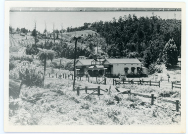
Photograph, The Busy Corner, 1907
... ...barbers road...The horse is “Blossom”. Barbers Road goes to the left from behind the elm trees....The horse is “Blossom”. Barbers Road goes to the left from behind the elm trees. ...View of Jeeves Saddle in 1907 showing everyday life and including important people and businesses from early settlement - Dodd's grocery and meat cutting carts; Beulah tea Rooms/Post Office; Mrs Hand, Fred Jeeves, Theo Hand.This photograph has a detailed inscription on the back handwritten by John Lundy-Clarke in 1974.“Jeeves Saddle” in 1907. Isaac Jeeves special strip of land Crown Allotment “C” 7 chains wide, lay between the sledge load of pea stalks and the far end of the verandah on Mrs Hand’s “Beulah Tea Rooms” which soon afterwards became the Mt Dandenong North Post Office. The coach road came up from the right behind the tall stump. The big woman in black was Mrs Hand. The wagon at the shop was Dodd’s grocery cart. The nearer wagon was the first coach on the mountain which had belonged to Briarty. The small cart was Dodd’s meat cutting cart. The elm trees are in the centre of the picture and above them is Price’s sign advertising their shop and newsagency. The big house is “Mountjoy” burnt 1975. Walker’s house is among the big trees left centre. Boy at horse’s head is Fred Jeeves. Boy on sledge is Theo Hand. The horse is “Blossom”. Barbers Road goes to the left from behind the elm trees.jeeves, theo hand, fred jeeves, isaac jeeves, barbers road, beulah tea rooms, post office, mount dandenong north, mt dandenong north, kalorama, coach, mountjoy -
 Mt Dandenong & District Historical Society Inc.
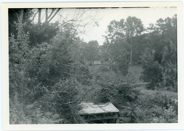
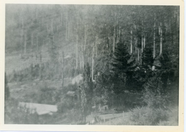
Photograph, View from George Barber's Home To His Stables
... barbers road...This photograph was taken by John Lundy-Clarke in 1973 to show changes to the environment sine 1905. barbers road john lundy-clarke kalorama View from Barbers drive to his stables close to where 1905 picture was taken. ...John Lundy-Clarke grew up in the Kalorama/Mt Dandenong area and later in life (1972-74) began to write a comprehensive history of the area working from an original settlement map in an effort to cover all areas. This photograph was taken by John Lundy-Clarke in 1973 to show changes to the environment sine 1905.Black and white photograph with tangled bush and small shed in foreground looking towards a cleared area. Handwritten description on reverse written by John Lundy-ClarkeView from Barbers drive to his stables close to where 1905 picture was taken. Stables in foreground. Looking towards Gap. Taken JLC November 1973.barbers road, john lundy-clarke, kalorama -
 Mt Dandenong & District Historical Society Inc.
Document, The Busy Corner
... Barbers Road...Farndons Community Hall 42 Falls Road Mt Dandenong yarra-valley-and-the-dandenong-ranges Barbers Road FiveWays Frederick Jeeves Post Office Ridge Road Theo Hand Mountjoy Information about photograph #KAL0059 'The Busy Corner' c19009. (2 pages) The Busy Corner Document ...Information about photograph #KAL0059 'The Busy Corner' c19009. (2 pages)barbers road, fiveways, frederick jeeves, post office, ridge road, theo hand, mountjoy -
 Mt Dandenong & District Historical Society Inc.
Photograph, View of the Kalorama Valley c1905
... This photograph c1905 is looking up from George Barber's house 'Forest Edge' on Barbers Road. 'Forest Edge' was built c1898 and was the home of George Barber and his wife Sarah Ann (nee Richardson). ...It was from one of these trees on the top left that the runaway log was cut that leaped over Barbers Road (at the top edge of the cleared land) then over Logan’s house in one bound in 1930.... house 'Forest Edge' on Barbers Road. 'Forest Edge' was built c1898 and was the home of George Barber and his wife Sarah Ann (nee Richardson). ...John Lundy-Clarke grew up in the Kalorama/Mt Dandenong area and later in life (1972-74) began to write a comprehensive history of the area working from an original settlement map in an effort to cover all areas. This photograph c1905 is looking up from George Barber's house 'Forest Edge' on Barbers Road. 'Forest Edge' was built c1898 and was the home of George Barber and his wife Sarah Ann (nee Richardson). The buildings in the foreground are the stables and hayshed.Black and white photograph showing two small buildings in the foreground with cleared hills behind. Handwritten decription on back by John Lundy-ClarkeA 1905 view of the Kalorama Valley towards the Gap. Barbers stables in foreground with hayshed on left. Tait’s house in centre of picture with Logans in the same fold above the hayshed. “Kalorama” is centre of Gap with Paynter’s “Iona” on its left with stables to its left. It was from one of these trees on the top left that the runaway log was cut that leaped over Barbers Road (at the top edge of the cleared land) then over Logan’s house in one bound in 1930.george barber, sarah ann barber, john lundy-clarke, forest edge -
 Mt Dandenong & District Historical Society Inc.
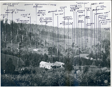
Photograph, "Kia-Ora' Guest House. Kalorama Valley c1900, c1900
... Landscape view from Barbers Road across the valley. Kia-Ora was built by George Barber in 1909 and run as a guest house. ...Farndons Community Hall 42 Falls Road Mt Dandenong yarra-valley-and-the-dandenong-ranges kalorama valley kia-ora guest house mountain of struggle john lundy-clarke Landscape view from Barbers Road across the valley. Kia-Ora was built by George Barber in 1909 and run as a guest house. ...Landscape view from Barbers Road across the valley. Kia-Ora was built by George Barber in 1909 and run as a guest house. John Lundy-Clarke annotated the properties shown with the owners' names. Excellent companion piece to J L-C's "Mountain of Struggle".kalorama valley, kia-ora guest house, mountain of struggle, john lundy-clarke -
 Mt Dandenong & District Historical Society Inc.
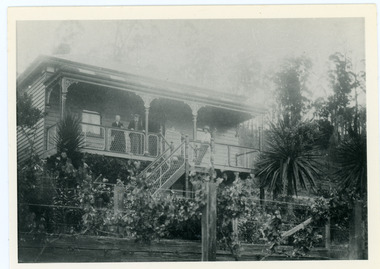
Photograph, Home of George and Sarah Barber c1905
... George and Sarah Ann Barbers home "Forest Edge' on Barber's Road. Jabez Richardson (father of Sarah Ann) and his wife Sarah jane are standing on the front verandah. ...Farndons Community Hall 42 Falls Road Mt Dandenong yarra-valley-and-the-dandenong-ranges George and Sarah Ann Barbers home "Forest Edge' on Barber's Road. ...George and Sarah Ann Barbers home "Forest Edge' on Barber's Road. Jabez Richardson (father of Sarah Ann) and his wife Sarah jane are standing on the front verandah. An unknown male is also in the picture.Black and white photograph showing four adults standing on the front verandah of a house. Reverse of photograph has handwritten description by John Lundy-Clarke.Jabez and Sarah Jane Richardson on verandah of home of their daughter Sarah Ann (Mrs Barber) 1905. Sarah jane died 1906. Jabez died 1908.forest edge, george barber, sarah ann richardson, sarah ann barber, jabez richardson, sarah jane richardson -
 Mt Dandenong & District Historical Society Inc.
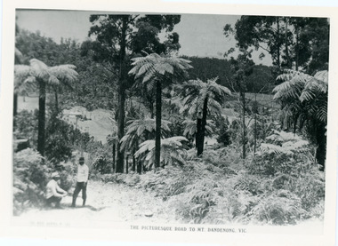
Photograph, View From Doughty's Road 1913
... 1913 View east from Doughty’s Road showing Jeannie Richardson’s home through the gap in the trees. A little to the right of and below centre of picture can be seen George Barber’s home with Barbers Road turning around the wagon shed that was a little up the hill from the house. ...A little to the right of and below centre of picture can be seen George Barber’s home with Barbers Road turning around the wagon shed that was a little up the hill from the house. ...Mt Calvin, the homestead of Jeanie and Willie Richardson can be clearly seen in the clearing above the men in the picture. The white roof of the Barber homestead is on the right of the picture. A landslide in 1934 destroyed the tree ferned area. John Lundy-Clarke grew up in the Kalorama/Mt Dandenong area and later in life (1972-74) began to write a comprehensive history of the area working from an original settlement map in an effort to cover all areas.Black and white photograph that is a copy of a Rose series postcard titled 'The Picturesque Road to Mt. Dandenong. Vic.' It shows two men (probably Rose Series employees), one sitting and one standing at the edge of an unmade road. Large tree ferns line the roadside. Handwritten inscription on reverse by John Lundy-Clarke1913 View east from Doughty’s Road showing Jeannie Richardson’s home through the gap in the trees. A little to the right of and below centre of picture can be seen George Barber’s home with Barbers Road turning around the wagon shed that was a little up the hill from the house. The tree ferns in the picture were destroyed in the landslide of 1934. In the distance at the right can be seen F.M. Childs Homestead complex with the Richardson paddocks beyond it.mt calvin, jeanie richardson, willie richardson, george barber, landslide, tree fern -
 Mt Dandenong & District Historical Society Inc.
Photograph, View From George Barber's Home On Olinda Creek Towards The Gap. c1905, 1905
... Logan’s house can just be seen under magnifier at top of same gully near line of Barber’s Road. “Kalorama” just below lowest portion of Gap skyline with Barnes (Paynters) house “Iona” to its left. ...Logan’s house can just be seen under magnifier at top of same gully near line of Barber’s Road. “Kalorama” just below lowest portion of Gap skyline with Barnes (Paynters) house “Iona” to its left. ...Black and white photograph showing view towards The Gap (Jeeves Saddle), (Five Ways) taken c1905. Detailed inscription on back handwritten by John Lundy-Clarke in 1973.1905 (c ) view from Barber’s home on Olinda Creek, towards the Gap, then known as Jeeves Saddle. Barber’s stable in foreground. “Shiloah” Complex centre right. Tait’s house in gully just left of centre. Logan’s house can just be seen under magnifier at top of same gully near line of Barber’s Road. “Kalorama” just below lowest portion of Gap skyline with Barnes (Paynters) house “Iona” to its left. Photo copied 1973. JLC. george barber, shiloah, kalorama, iona, olinda creek, the gap, jeeves saddle, tait, paynter, barber -
 Mt Dandenong & District Historical Society Inc.
Photograph, Harry Walker's Home in Village Settlement 1908, c1908
... Looking from what is now Ridge Road through the trees on Vil. Set Lot 18 to Barber’s house now known as “Forest Edge” on Vil Set Lot 25 down close to the Olinda Creek on Barbers Road. ...Looking from what is now Ridge Road through the trees on Vil. Set Lot 18 to Barber’s house now known as “Forest Edge” on Vil Set Lot 25 down close to the Olinda Creek on Barbers Road. ...View of Harry Walker's home taken from waht is now known as Ridge Road, Kalorama. Raspberry crops are in the foreground. This photograph has a detailed inscription on the back handwritten by John Lundy-Clarke in 1974.1908 view of H Walker’s home on Village Settle Lot 2 Section 1. Looking from what is now Ridge Road through the trees on Vil. Set Lot 18 to Barber’s house now known as “Forest Edge” on Vil Set Lot 25 down close to the Olinda Creek on Barbers Road. The Estate Agent’s modern office is on the edge of the patch of raspberries at the lower left as the C.R.B. Mt Dandenong Rd passes just behind Walker’s house crossing the picture behind the raspberries.walker, raspberry crop, forest edge, barber -
 Mt Dandenong & District Historical Society Inc.
Photograph, View Over Roof of "Kalorama"
... It leaped in one bound over Barbers Road at bottom of scrub in centre of picture then over Logan’s house....It leaped in one bound over Barbers Road at bottom of scrub in centre of picture then over Logan’s house. ...Taken in 1908, this photograph, though rather blurry, gives an indication of the location of the early settler properties in the valley in relation to one another. European trees have been planted at 'Kalorama' , the first home of Ellis Jeeves. John Lundy-Clarke grew up in the Kalorama/Mt Dandenong area and later in life (1972-74) began to write a comprehensive history of the area working from an original settlement map in an effort to cover all areas.Black and white photograph looking across hillside with large trees and rooftops visible. Handwritten description on reverse by John Lundy-Clarke.1908 View over roof of “Kalorama” towards the Falls. Paynter’s house on LOT 29 in low centre (now “Yosemite”). Pimms house on LOT 19 above Paynters and beyond scrub. Logan’s house faint above left of “Kalorama”. Dunbar’s LOT 20 beyond Pimm’s orchard. Gum trees on right were on Price’s LOT 19 now Tosari Rd area. It was one of these that figured in the episode of the runaway log in 1930. It leaped in one bound over Barbers Road at bottom of scrub in centre of picture then over Logan’s house.kalorama, ellis jeeves, jeeves -
 Box Hill Historical Society
Photograph - Businesses, c1940s
... Customers at Sid Lawrie's barber shop in Whitehorse Road 1945-1950 ...Syd Lawries, Barber shop, Whitehorse Road, Box Hill, Victoria, Australia...Customers at Sid Lawrie's barber shop in Whitehorse Road 1945-1950 Barber shops Hairdressers 1940s Lawrie> Sid Businesses B&w photo Photograph Businesses ...Customers at Sid Lawrie's barber shop in Whitehorse Road 1945-1950 B&w photobarber shops, hairdressers, 1940s, lawrie> sid, businesses -
 Mt Dandenong & District Historical Society Inc.
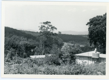
Photograph, View From Ernest Road To Site Of "Kia-Ora"
... The photograph taken c1973 from Ernest Road looks over the site of the Kia-Ora guesthouse which is marked by the oalm tree that can be seen at the front of the flat roof close to the gum tree trunk. Situated on Barber’s Road, ‘Kia-Ora’ was built in 1912 by George Barber. ...The photograph taken c1973 from Ernest Road looks over the site of the Kia-Ora guesthouse which is marked by the oalm tree that can be seen at the front of the flat roof close to the gum tree trunk. Situated on Barber’s Road, ‘Kia-Ora’ was built in 1912 by George Barber. ...John Lundy-Clarke grew up in the Kalorama/Mt Dandenong area and later in life (1972-74) began to write a comprehensive history of the area working from an original settlement map in an effort to cover all areas. The photograph taken c1973 from Ernest Road looks over the site of the Kia-Ora guesthouse which is marked by the oalm tree that can be seen at the front of the flat roof close to the gum tree trunk. Situated on Barber’s Road, ‘Kia-Ora’ was built in 1912 by George Barber. It was later leased by a Mrs Pemberthy. “Kia-Ora’ was one of four places connected when the telephone was brought into the district in 1912. The other places were ‘Mountjoy’, ‘Cherry Farm’ and ‘Callum House’. ‘Kia-Ora’ was burnt down in 1924.Black and white photograph showing a house with water tank in right foreground and another flat roof centre foreground. There is a handwritten description by John Lundy-Clarke on the reverse.View 1973 from corner of Ernest Rd and Outlook Drive Lot 24 Village Settlement looking over the site of “Kia Ora” to the pioneers clearings. The palm tree seen above the flat roof (Rex) on left, is on the exact site of “Kia Ora”. Photo JLCernest road, john lundy-clarke, kia=ors, guest house, guesthouse -
 Mt Dandenong & District Historical Society Inc.
Photograph, Walker's LOT 2
... The tall trees to the right of the vista were on Price’s LOT 18 and it was while cutting up one of these for firewood that a length of log weighing about ½ a ton got away downhill and leaped in one bounce over Barbers Road and Logan’s house – 1931....The tall trees to the right of the vista were on Price’s LOT 18 and it was while cutting up one of these for firewood that a length of log weighing about ½ a ton got away downhill and leaped in one bounce over Barbers Road and Logan’s house – 1931. Black and white photograph showing a single storey white house in the centre surrounded by crops. ...Lot 2 was bought by Harry Walker in the early 1900s. Harry was married to Eva Hand, one of the six daughters of Thomas and Eliza Hand. Harry cleared the land and planted half with raspberries that remained productive until c1928. Harry's son William took over the property. The land was cut in half when the new CRB road went through in the early 1920s. John Lundy-Clarke grew up in the Kalorama/Mt Dandenong area and later in life (1972-74) began to write a comprehensive history of the area working from an original settlement map in an effort to cover all areas.Black and white photograph showing a single storey white house in the centre surrounded by crops. Handwritten description on reverse by John Lundy-Clarke.VIEW 1908 OVER LOT 2 SECTION 1 VILLAGE SETTLEMENT. TAKEN FROM RIDGE ROAD THEN MAIN ROAD FROM HALFWAY BETWEEN MOUNTJOY AND FALLS RD. CRB MAIN RD RUNS BEHIND WALKER’S HOUSE. The house seen in the vista among the tall trees beyond the raspberry patch is “Forest Edge” which was George Barber’s home when the picture was taken. The tall trees to the right of the vista were on Price’s LOT 18 and it was while cutting up one of these for firewood that a length of log weighing about ½ a ton got away downhill and leaped in one bounce over Barbers Road and Logan’s house – 1931.harry walker, william walker, eva hand, crb road, raspberries, kalorama -
 Mt Dandenong & District Historical Society Inc.
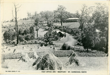
Photograph, Post Office and 'Mountjoy', Mt. Dandenong North, 1913
... The house to the right of and high up the pine tree is Walker’s cottage which exists today opposite Jack Kidd’s home at the far edge of Lt 2 Village Settlement and was between Main Road and Barbers Road which runs down the left behind the elms. ...The house to the right of and high up the pine tree is Walker’s cottage which exists today opposite Jack Kidd’s home at the far edge of Lt 2 Village Settlement and was between Main Road and Barbers Road which runs down the left behind the elms. ...Rose Series post card #182Copy of Rose Series postcard #182 showing Kalorama Gap in 1913. Haystacks in foreground with Mountjoy Guest House and Beulah Tea Rooms/Mt Dandenong North Post Office in centre. This photograph has a detailed inscription on the back handwritten by John Lundy-Clarke in 1974.Kalorama Gap in 1913 The elm trees are in the centre of the picture. One of these is really two as two suckers of the further tree were twisted together by Fred Jeeves in 1898 and grew as one tree. The other was planted in 1880. The shop is the shop of Mrs Eliza Hand and daughter Florence. The closed in far end of the verandah was the Mount Dandenong North Post Office. The large house is “Mountjoy” owned and run by the Jeeves Family from 1908 till 1943. It was built in 1905 by the Paynters who sold to Ellis Jeeves in 1908.He moved his line of coaches from “Kalorama” his old homestead and housed the horses in a line of stables behind “Mountjoy”. Price’s house, which contained their shop, the first one on the mountain, opened 1906, can be seen faintly behind the pine tree opposite the bend in the road, which was the main road then and now is Ridge Road. The Price’s house just shows in two tiny pieces, one on each side of the pine tree half way up. The house to the right of and high up the pine tree is Walker’s cottage which exists today opposite Jack Kidd’s home at the far edge of Lt 2 Village Settlement and was between Main Road and Barbers Road which runs down the left behind the elms. Walker’s homestead can be seen near left edge of picture 2/3 way up. The roof of the Methodist Church shows among trees left of picture. This, like Mrs Hand’s shop was built on portions separated from Isaac Jeeves’ Selection “C” known as Jeeves Saddle. kalorama gap, five ways, mountjoy, john lundy-clarke, beulah tea rooms, post office, fred jeeves, paynter, jeeves, frederick jeeves, price, walker, jack kidd -
 Mt Dandenong & District Historical Society Inc.
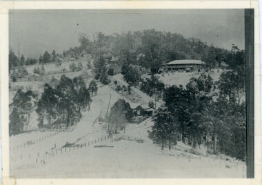
Photograph, Kalorama Gap Under Snow 1921, 1921
... The CRB had recently fenced the road and this is clearly seen as it circles behind trees in the left centre. Barber’s Road crosses CRB Road to the left of the dray under the leafless elm and the Coach Road dives down to the right just behind the pair of blackwoods to right of the elms. ...The CRB had recently fenced the road and this is clearly seen as it circles behind trees in the left centre. Barber’s Road crosses CRB Road to the left of the dray under the leafless elm and the Coach Road dives down to the right just behind the pair of blackwoods to right of the elms. ...View of Kalorama Gap under snow taken in 1921. Mountjoy Guest House is at top right and Beulah Tea Rooms is in the centre. This photograph has a detailed inscription on the back handwritten by John Lundy-Clarke in 1974.Kalorama Gap under snow 1921 The leafless elm trees are low in the centre and the dual nature of the nearer one can be clearly seen, two small suckers of the older farther tree being twisted together in 1898 by Fred Jeeves. The older tree was planted 1880. Mrs Hands shop can be clearly seen, which was the Mount Dandenong North Post Office. The old Main Road runs up the centre of the picture and turns to the right and disappears behind “Mountjoy” the big guest house built by Paynters in 1905 and sold to Ellis Jeeves 1908, whose family ran it till 1943. At the bend of the road behind the big pine tree and the dark blackwood can be seen faintly the gable of Price’s house that contained the first shop on the mount. Above it is H Walker’s cottage on Ridge Road that still exists, his homestead is on the left of the picture on the same level. Below this house and to the left can be seen Ted Prices hay and corn store. The present estate agency lies between these two buildings, on the road which had recently been built. This can be seen winding from the lower left corner of picture to the left of the elms. The CRB had recently fenced the road and this is clearly seen as it circles behind trees in the left centre. Barber’s Road crosses CRB Road to the left of the dray under the leafless elm and the Coach Road dives down to the right just behind the pair of blackwoods to right of the elms. The picture was taken from just above the boundary of Isaac Jeeves’s selection Crown Allotment “C” (Jeeves Saddle) which stretched across the Gap to the other side of Mrs Hand’s shop, monopolising the gap from 1871 to 1879. Price’s house remains partly as the small house – “Mirra Laken”. kalorama gap, fiveways, post office, mountjoy, guest house, snow -
 Warrnambool and District Historical Society Inc.
Documents, William Ardlie Archives, C 1900-1940
... road This collection of papers have come from the offices of William Ardlie a local solicitor. He was born in Moonee Ponds in 1843 and was admitted as an attorney and solicitor of the supreme Court in 1865. From 1867 to 1878 he was in partnership with George Barber ...This collection of papers have come from the offices of William Ardlie a local solicitor. He was born in Moonee Ponds in 1843 and was admitted as an attorney and solicitor of the supreme Court in 1865. From 1867 to 1878 he was in partnership with George Barber and then continued to practise until his late eighties which made him the oldest practising lawyer in Australia. He was involved in local councils and organisations such as the Hospital and Anglican Church.He was associated with several large homes in Warrnambool including Wyton presently the home of Emmanual College Warrnambool. He died in 1933.His son E L Ardlie also practised as a solicitor from the same offices from 1893. A number of the invoices included relate to the Estate of James drought who was a local policeman and owner of a number of properties and operated in various trades such as George Ramsay manufacturer of stoves and chimneys, J Rogers plumber & gas fitter and Christian & Dodds who were carpenters and joiners. There are a number of documents which relate to the Chinese, many of whom operated market gardens along the Merri River. They were a familiar part of Warrnambool from around 1872 until around 1940. The names mentioned in these documents include Ah Foo,Charles Quing Bow, Andrew Quing Bow Ah Bing Ah Jing Ah Moon and Ah Seong. They were reknown for their supply of fresh vegetables to the people of the town. They leased land from John Moore. These documents are a cross section of the types of documents which were used and are still used in the operation of businesses. They provide a social snapshot of people and the business which they conducted with their solicitors in this case William and E L Ardlie who were a long standing legal firm in the district. Another interesting aspect of some of these documents is the leases signed by the Chinese market gardeners who played an important but often overlooked aspect of Warrnambool's aspect.A total of 27 documents which relate to William Ardlie Solicitors 001133.1Policy from The Victoria Insurance Company for office effects, 001133.1.2 Receipt for 11/1 for policy. 001133.2 Renewal Receipt from Messrs Hammond & Richards as agents for Victoria Insurance Co. 001133.3 Renewal Receipt from Messrs Hammond & Richards as agents for Victoria Insurance Co. 001133.4 General rates receipt . City of Warrnmbool. 001133.5 Water rates receipt . City of Warrnmbool. 001133.6 Camperdown Chronicle , Letter re overdue payment 001133.7 Camperdown Chronicle Statement 31/12/1948 001133.8 Transfer of land notice Ben Rogers Mepunga 001133.9 W H Philpott Account for rent Estate R P Thomas 001133.10 George Ramsay account for Mr Walters for stove setting. 001133.11 Archibald Macfarlane & Co account for Estate James Drought for advertising. 001133.12 Letter to E L Ardlie re deed of Keane family arrangements 21/10/1910 001133.13 Letter to E L Ardlie re charges of Keane Estate 14/12/1910 001133.14 Account to E L Ardlie from J Rogers re estate Mr Drought , repairs.1/08/1906 001133.15 Account to EL Ardlie from J Rogers re estate Mr Drought1/10/1907 001133.16 Account to William Ardlie from J Rogers re estate Mr Drought 01/07/1908 001133.17 Account to William Ardlie from J Rogers re estate Mr Drought 01/07/1908 001133.18 State Savings Bank Victoria passbook of Margaret Molan 1/02/1937 001133.19 Account to E L Ardlie from Christian & Dodds repairs to Droughts house 01/07/1905 001133.20 Account to E L Ardlie from Christian & Dodds for Estate of Drought for house repairs Darling St1/10/1905 001133.21 Estimate to A A Briggs from Christian & Dodds for Estate of Drought 06/04/1908 001133.22 Receipt to E L Ardlie from Christian & Dodds for Estate of Drought for house repairs 01/05/1906 001133.23 Lease Indenture 02/06/1922 between William Ardlie andAH Foo re Crown Allotment 144 Wangoom for 70 pounds. 001133.24 Agreement 18/06/1929 Messrs Quing Bow & Sons to Messrs Ah Bing Ah Jing Ah Moon and Ah Seong witnessed John Moore. 001133.25 Lease indenture made 18/06/1929 betweenWilliam Ardlie to messrs Ah Bing Ah Jing Ah Moon and Ah Seong. 001133.26 Agreement 18/06/1929 Messrs Quing Bow & Sons to Messrs Ah Bing Ah Jing Ah Moon and Ah Seong witnessed John Moore 001133.27.1 Notification to Creditor of issue of stay order farmers Debts adjustment Act 1935 to Ellen C McGinness and Estate of john McGinness 001133.27.2Note re monthly inst of interest Estate McGinness1942 001133.27.3 Estate of j A Bromfield re Estate of McGinness Arrears of Interest1943 001133.27.4 Letter to W Ardlie from The Trustees Executors & Agency Co Ltd24/02/1944 re interest on J A Bromfield's trust re McGinness mortgage. 001133.27.5 Letter to W Ardlie from The Trustees Executors & Agency Co Ltd 25/02/1944 re interest on J A Bromfield's trust re McGinness mortgage. 001133.27.6 William Ardlie to The Trustees Executors & Agency Co Ltd re Bromfield & McGinness 24/02/1944 001133.27.7 The Trustees Executors & Agency Co Ltd to William Ardlie re receipts 16/03/1944 001133.27.8 The Trustees Executors & Agency Co Ltd to William Ardlie re Bromfield & McGinness18/03/1944 Unable to complete enquiries. 001133.27.9 The Trustees Executors & Agency Co Ltd to William Ardlie 27/03/1944 001133.27.10 The Trustees Executors & Agency Co Ltd to William Ardlie29/04/1944 001133.27.11 Estate Sarah Donaldson re accrued Interest 1933-1961 001133.28.1 Indenture between Emily Maria Briggs,Mary Jane Briggs, Frederick William Briggs, Fanny Alethea Briggs, James Alfred Briggs,Lucy Annie Briggs, Arthur Albert Briggs , and Mary Ann Briggs 001133.28.2 Letter re estate of Mary Ann Briggs 001133.1 No 590911 001133.1.2 Signed G Begley 001133.2 Hammond & Richards 43/5 Kepler St Warrnambool 001133.3 Hammond & Richards 43/5 Kepler St Warrnambool 03/03/1934 001133.4 W Ardlie 18/06/1929 Thomas Beattie collector 001133.5 W Ardlie 18/06/1929 Thomas Beattie collector 001133.6 Wm Ardlie signed W A Donald10/08/1949 001133.7 Wm Ardlie 31/12/1948 001133.8 Alexander Ben Rogers 26/05/1950 001133.9 Estate R P Thomas 28/061955. Phone 124 001133.10 .Mr Walters Drought A Ramsay 01/05/1906 001133.11 Estate of the late James Drought 24/05/1906 001133.12 W F Molesworth Re Thomas Keane. Phone 81. 21/10/1910 001133.13 W F Molesworth Phone 81 Thomas Keane14/12/1910 001133.14 E L Ardlie Joseph Rogers 13/08/1906 001133.15 E L Ardlie Joseph Rogers 01/10/1907 001133.16 E L Ardlie 01/07/1908 001133.17 Estate Late Mr Drought 01/07/1908 001133.18 Miss Margaret Molan 001133.29 L Ardlie 01/07/1905 001133.20 E L Ardlie 01/10/1905 001133.21 Mr A A Briggs Christian & Dodds 06/04/1908 001133.22 L Ardlie W Christian 01/05/1906 001133.23 Stamp duty 04/061926 Signed William Ardlie Est Conway Ah Foo 001133.24 Signed John Moore, Charles Quing Bow, Andrew Quing Bow, Ah Bing, Ah Jing, Ah Moon, Ah Seong. 001133.25 Signed William Ardlie, E H Conway, Ah Bing, Ah Jing, Ah Moon, Ah Seong, John Moore. 001133.26 Signed John Moore, Charles Quing Bow, Andrew Quing Bow, Ah Bing, Ah Jing, Ah Moon, Ah Seong. 001133.27.1 Ellen C McGinness and Estate of John McGinness James Dickson R R Macfarlane Richard Vincent McGinness, Abraham McGinness, John Ambrose McGinness 14/07/1936 001133.27.2 Note re monthly inst of interest Estate McGinness 1942 001133.27.3 J A Bromfield McGinness 001133.27.4 W Ardlie, The Trustees Executors & Agency Co Ltd 24/02/1944 J A Bromfield's trust re McGinness mortgage. Syd Jackson 001133.27.5 W Ardlie ,The Trustees Executors & Agency Co Ltd 25/02/1944 J A Bromfield's trust re McGinness mortgage.Syd Jackson 001133.27.6 William Ardlie The Trustees Executors & Agency Co Ltd re Bromfield & McGinness 24/02/1944 001133.27.7 The Trustees Executors & Agency Co Ltd William Ardlie 16/03/1944 001133.27.8 The Trustees Executors & Agency Co Ltd William Ardlie Bromfield & McGinness 18/03/1944 001133.27.9 The Trustees Executors & Agency Co Ltd William Ardlie 27/03/1944 001133.27.10 The Trustees Executors & Agency Co Ltd William Ardlie 29/04/1944 001133.27.11 Estate Sarah Donaldson 1933-1961 001133.28.1 Miss Emily m Briggs to Mrs Mary Ann Briggs Assignment . Stamped William Ardlie Solicitor Warrnambool. warrnambool,, william ardlie, james drought, christian & dodds, chinese of warrnambool, james a bromfield