Showing 18 items matching "beaconsfield ranges"
-
 Narre Warren and District Family History Group
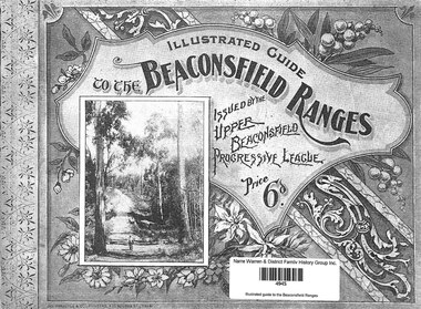
Book, Green Circle Plant Nursery (volunteer), Illustrated guide to the Beaconsfield Ranges, 2018
... Illustrated guide to the Beaconsfield Ranges......beaconsfield ranges...Narre Warren and District Family History Group 110 High Street Berwick melbourne upper beaconsfield (vic.) beaconsfield ranges A reproduction of the Illustrated Guide to the Beaconsfield Ranges, that was first published in 1899 by the Upper Beaconsfield Progressive League 40 p.; 25 cm Illustrated guide to the Beaconsfield Ranges Book Green Circle Plant Nursery (volunteer) ...A reproduction of the Illustrated Guide to the Beaconsfield Ranges, that was first published in 1899 by the Upper Beaconsfield Progressive League40 p.; 25 cmnon-fictionA reproduction of the Illustrated Guide to the Beaconsfield Ranges, that was first published in 1899 by the Upper Beaconsfield Progressive Leagueupper beaconsfield (vic.), beaconsfield ranges -
 Emerald Museum & Nobelius Heritage Park
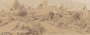
Photograph, Early postcard, Emerald Victoria, 1909
... ranges Formally Main Road, Emerald; now called Emerald Gembrook Road. Depicts 7 buildings, 6 identified as follows from right to left: Abbatoir, Cooper's Butcher, Andrew's General Store, Madigan's Bakery, Archilbald & Moffatt Grocery and Bakery, Walter's Barber Store 1909 photograph of the commercial district in Emerald, emerald commercial district Front: Emerald Victoria Handwritten on Back: Dec. 1909 (pencil); 'Wishing you the compliments of the season, hoping you will drive over some day and see how we are getting on. From RJ....? Emerald. To: Rev'd Whiteside, Beaconsfield ...Formally Main Road, Emerald; now called Emerald Gembrook Road. Depicts 7 buildings, 6 identified as follows from right to left: Abbatoir, Cooper's Butcher, Andrew's General Store, Madigan's Bakery, Archilbald & Moffatt Grocery and Bakery, Walter's Barber Store1909 photograph of the commercial district in Emerald, Faded sepia postcard depicting Emerald Main Street, Commercial District (1909)Front: Emerald Victoria Handwritten on Back: Dec. 1909 (pencil); 'Wishing you the compliments of the season, hoping you will drive over some day and see how we are getting on. From RJ....? Emerald. To: Rev'd Whiteside, Beaconsfield Railway Station. Vicemerald, commercial district -
 Emerald Museum & Nobelius Heritage Park
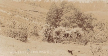
Photograph, Postcard Emerald Nursery 1909, 27.2.09
... ranges Early photograph of possibly Nobelius Nursery? early emerald nobelius Front: Nursery Emerald, Back: In pencil, 27.2.09; Ink: Dear Maref? from Auntie & Uncle...th? best wishes and Merry Xmas & a bright happy New Year. J & RJ Craig Emerald. Sent to: Miss Whiteside Beaconsfield ...Early photograph of possibly Nobelius Nursery?Faded sepia postcard depicting Nobelius Nursery?Front: Nursery Emerald, Back: In pencil, 27.2.09; Ink: Dear Maref? from Auntie & Uncle...th? best wishes and Merry Xmas & a bright happy New Year. J & RJ Craig Emerald. Sent to: Miss Whiteside Beaconsfield Railway Station Vic. early emerald nobelius -
 Emerald Museum & Nobelius Heritage Park
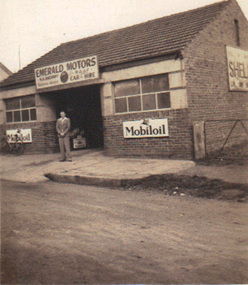
Photograph, Emerald Motors, circa 1930's - 40's
... Emerald Museum & Nobelius Heritage Park 5 Crichton Rd Emerald yarra-valley-and-the-dandenong-ranges Sherriff's Garage started in the Blacksmith's shop (originally Stapletons Blacksmith) , cnr. Kilvington Drive (the Beaconsfield Road) and Main Road. ...Sherriff's Garage started in the Blacksmith's shop (originally Stapletons Blacksmith) , cnr. Kilvington Drive (the Beaconsfield Road) and Main Road. Early history of the commercial district of EmeraldSmall sepia photograph depicting Emerald Motors with (possibly) owner Herbie Sherriff standing out front of businessNo inscriptions, but Kodak manufacturing mark on backemerald motors, herbie sherriff, mobiloil signage -
 Emerald Museum & Nobelius Heritage Park
B/W Photograph, Holman Family
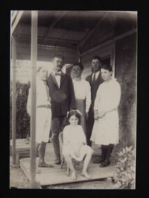
... Emerald Museum & Nobelius Heritage Park 5 Crichton Rd Emerald yarra-valley-and-the-dandenong-ranges The Holman family ran the Guest House near The Falls, Beaconsfield. Left to Right: John Basil Holman, Bostraze Holman (father),front seated Barbara Molesworth Holman, Ellen Molesworth Holman (mother), Derrick Hewlett Holman, Mary Joyce Holman. ...The Holman family ran the Guest House near The Falls, Beaconsfield. Left to Right: John Basil Holman, Bostraze Holman (father),front seated Barbara Molesworth Holman, Ellen Molesworth Holman (mother), Derrick Hewlett Holman, Mary Joyce Holman. Photo taken at Bamawm c.1921?holman, guest house, the falls, beaconsfield -
 Emerald Museum & Nobelius Heritage Park
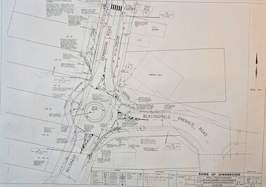
Map - Surveyors Map of new roundabout to be installed at the intersection of Belgrave-Gembrook Rd. and Beaconsfield-Emerald Rd., Emerald 1989, Shire of Sherbrook, Roundabout at intersection of Belgrave-Gembrook Rd., and Beaconsfield-Emerald Rd., Emerald, drawn 1989 - surveyors map, c1989
... Emerald Museum & Nobelius Heritage Park 5 Crichton Rd Emerald yarra-valley-and-the-dandenong-ranges Shire of Sherbrooke/Emerald Township roundabouts Belgrave-Gembrook Rd./Beaconsfield-Emerald Road/Monbulk Rd. ...Image of surveyors map outlining dimensions for new roundabout at the intersection of Belgrave-Gembrook Rd., and Beaconsfield-Emerald Rd. 1989non-fiction -
 Emerald Museum & Nobelius Heritage Park
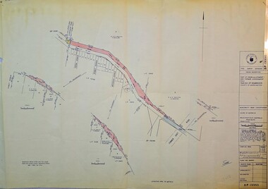
Map - Municipality Road Classification - Beaconsfield-Emerald Rd., Shire of Gembrook 1973, Title Survey Division, Crown Description - Part of Crown Allotment 44, Parish of Gembrook, County of Mornington, c1973
... Emerald Museum & Nobelius Heritage Park 5 Crichton Rd Emerald yarra-valley-and-the-dandenong-ranges Title Survey Division/Crown Description/Part of Crown Allotment 44, Parish of Gembrook, County of Mornington/Municipality Road Classification, Shire of Berwick, Beaconsfeld-Emerald Rd. (MR)/Francis J Webber of Kirkpatrick & Webber, 285 Maroondah Hwy., Ringwood/(Signed) - Principal Title Survey Office 16.1.73/SP13461 Image of Crown Survey Map for crown allotment 44 (Beaconsfield-Emerald Rd.) parish of Gembrook, County of Mornington Title Survey Division, Crown Description - Part of Crown Allotment 44, Parish of Gembrook, County of Mornington Map Municipality Road Classification - Beaconsfield-Emerald Rd., Shire of Gembrook 1973 ...Image of Crown Survey Map for crown allotment 44 (Beaconsfield-Emerald Rd.) parish of Gembrook, County of MorningtonTitle Survey Division/Crown Description/Part of Crown Allotment 44, Parish of Gembrook, County of Mornington/Municipality Road Classification, Shire of Berwick, Beaconsfeld-Emerald Rd. (MR)/Francis J Webber of Kirkpatrick & Webber, 285 Maroondah Hwy., Ringwood/(Signed) - Principal Title Survey Office 16.1.73/SP13461 -
 Emerald Museum & Nobelius Heritage Park
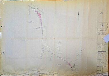
Map - Survey Map - Municipality Road Classification - Beaconsfield-Emerald Rd. (near Downey Rd.) 1972, Title Survey Division, Crown Description - part of Crown Allotments 39A and 39D, Parish of Gembrook, County of Mornington, c1972
... Emerald Museum & Nobelius Heritage Park 5 Crichton Rd Emerald yarra-valley-and-the-dandenong-ranges Title Survey Division/Crown Description/Part of Crown Allotments 39A and 39D, Parish of Gembrook,County of Mornington/Municipality Road Classification - Shire of Berwick, Beaconsfield - Emerald Rd, Upper Beaconsfield - Upper Pakenham Road/John L Dwyer of Fisher Cleeland Turner & Dwyer Pty. ...Image of Crown survey map - changes to allotments bordering Beaconsfield-Emerald Rd. near Downey Rd. in 1972Title Survey Division/Crown Description/Part of Crown Allotments 39A and 39D, Parish of Gembrook,County of Mornington/Municipality Road Classification - Shire of Berwick, Beaconsfield - Emerald Rd, Upper Beaconsfield - Upper Pakenham Road/John L Dwyer of Fisher Cleeland Turner & Dwyer Pty. Ltd., 213 King Street, Melbourne - 14 April, 1972/S.R. CLARKE - Principal Title Survey Officer 5.9.72/SP 13072 -
 Emerald Museum & Nobelius Heritage Park
Map - Image of Surveyors Map of road classification - Beaconsfield-Emerald Rd. near Summit Ave., Emerald 1973, Crown allotment and former Govt. Road classification - Beaconsfield-Emerald Rd. near summit Ave., Emerald 1973, c1973
... Emerald Museum & Nobelius Heritage Park 5 Crichton Rd Emerald yarra-valley-and-the-dandenong-ranges Title Survey Division/Crown Description/Part of Crown Allotment and Former Government Rd., Parish of Gembrook, County of Mornington Image of Surveyors map indicating changes to Beaconsfield-Emerald Rd., near Summit Ave., Emerald Crown allotment and former Govt. ...Image of Surveyors map indicating changes to Beaconsfield-Emerald Rd., near Summit Ave., EmeraldTitle Survey Division/Crown Description/Part of Crown Allotment and Former Government Rd., Parish of Gembrook, County of Mornington -
 Emerald Museum & Nobelius Heritage Park
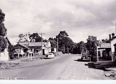
Photograph - Emerald-Beaconsfield Road 1940s, 1940s
... Emerald Museum & Nobelius Heritage Park 5 Crichton Rd Emerald yarra-valley-and-the-dandenong-ranges This photograph was taken on Beaconsfield Road in Emerald (now Kilvington Drive) looking from Emerald Main Street towards the train line. ...This photograph was taken on Beaconsfield Road in Emerald (now Kilvington Drive) looking from Emerald Main Street towards the train line. In the right of the image is the Teasdale store, on the location now used for storage by the Emerald Village Bakery. The store was owned by Joseph and Nell Teasdale, with Joseph's brother Edward operating a leatherworking business behind the store. Joseph and Nell's son, Kevin, suggested that what is now called Stapleton Walk instead be named "Forge Lane or Forge Walk," rather than solely representing Charles Stapleton's business across the lane from the Teasdales. On the left of the image is a sign denoting a school - possibly a back entrance to the nearby Emerald Primary School (number 3381) through the school oval. There are also other stores on the left, including what appears to be a newsagents. This is a copy of the original photograph; parts of the label have been lost in the process.This photograph depicts Emerald in the 1940s, showing several stores no longer in existence.A black and white photograph centered on an unsealed commercial road with shops on either side. One shop has a sign advertising Swallows Ice Cream, and another the Age and Leader newspapers. 1940s-style cars are parked on either side.Below image (Start cut off): "SFIELD ROAD, EMERALD" (Originally "BEACONSFIELD ROAD, EMERALD")emerald, transport, teasdale family, 1940s, commerce -
 Emerald Museum & Nobelius Heritage Park
Map - Municipality Road Classification - Beaconsfield - Emerald Rd., Shire of Berwick Alteration 1973, c1973
... Emerald Museum & Nobelius Heritage Park 5 Crichton Rd Emerald yarra-valley-and-the-dandenong-ranges Title Survey Division/Crown description/Crown allotment 47A and Part of Crown allotments1,46,47, 48A and former Government Rd., Parish of Gembrook, County of Mornington/Municipality Road Classification/Shire of Berwick, Beaconsfield-Emerald Road/Signed (Unreadable) Principal Title Survey Officer and Proper Officer 13.8.1973/SP13349 Image of map indicating Municipality Road Classification - Beaconsfield - Emerald Rd., Shire of Berwick Alteration 1973 Municipality Road Classification - Beaconsfield - Emerald Rd., Shire of Berwick Alteration 1973 Map Municipality Road Classification - Beaconsfield - Emerald Rd., Shire of Berwick Alteration 1973 ...Image of map indicating Municipality Road Classification - Beaconsfield - Emerald Rd., Shire of Berwick Alteration 1973Title Survey Division/Crown description/Crown allotment 47A and Part of Crown allotments1,46,47, 48A and former Government Rd., Parish of Gembrook, County of Mornington/Municipality Road Classification/Shire of Berwick, Beaconsfield-Emerald Road/Signed (Unreadable) Principal Title Survey Officer and Proper Officer 13.8.1973/SP13349 -
 Emerald Museum & Nobelius Heritage Park
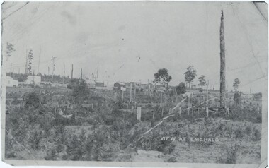
Photograph, View at Emerald, 1898
... Emerald Museum & Nobelius Heritage Park 5 Crichton Rd Emerald yarra-valley-and-the-dandenong-ranges Notes associated with this photograph indicate both that it was taken at the end of Heroes Avenue and that it was taken on 'Monbulk Road' - while these notes might simply be incorrect, it may also indicate that this may have been taken at what is now the intersection of Heroes Avenue and either Beaconsfield-Emerald Road or Kilvington Drive, potentially at the time under a different or incorrect name. ...Notes associated with this photograph indicate both that it was taken at the end of Heroes Avenue and that it was taken on 'Monbulk Road' - while these notes might simply be incorrect, it may also indicate that this may have been taken at what is now the intersection of Heroes Avenue and either Beaconsfield-Emerald Road or Kilvington Drive, potentially at the time under a different or incorrect name. This photograph was taken in 1898 when Emerald was much less densely occupied as a growing town amidst Nobelius' nursery.This photograph captures a side of Emerald that no longer exists, looking at the growing town from an outside that has long since been encompassed by the town.A black and white photograph of a landscape, with various buildings in the background and the road in the foreground. The photograph is quite small, which means scans of it are at quite a low resolution. There are several markings and copies of fold marks preserved from the original.Label: "VIEW AT EMERALD" Later note, rear of copy: "Heroes Ave end. 1898."emerald, 1890s -
 Emerald Museum & Nobelius Heritage Park
Map - Transparency of Beaconsfield-Emerald Rd. & adjacent property details, c1982
... Emerald Museum & Nobelius Heritage Park 5 Crichton Rd Emerald yarra-valley-and-the-dandenong-ranges Dandenong Valley Authority/Series 1:2500/Carrum 2500-2.32/Date Revised, classified data correct as at December 1982/Cadestral base prepared by the Survey Division, Dandenong Valley Authority under the dirction of M.G. DASHBURN, Chief Surveyor, October 1983 Transparency of Beaconsfield ...Transparency of Beaconsfield-Emerald Rd. & adjacent property detailsDandenong Valley Authority/Series 1:2500/Carrum 2500-2.32/Date Revised, classified data correct as at December 1982/Cadestral base prepared by the Survey Division, Dandenong Valley Authority under the dirction of M.G. DASHBURN, Chief Surveyor, October 1983 -
 Emerald Museum & Nobelius Heritage Park
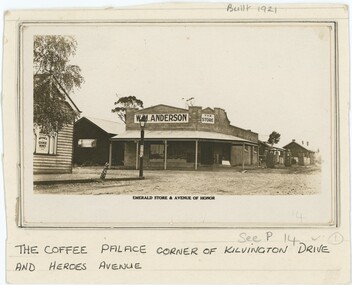
Photograph, Emerald Store & Avenue of Honor, 1920s-1940s
... Beaconsfield Road and, according to the label, Avenue of Honor. Anderson's store is believed to have been built by the Stillwell family in 1921, but Anderson had his store at least from 1923 and therefore likely owned it from the point of its first construction. By the late 1940s, Anderson's had become Legge's General Store. It is difficult to determine precisely when within that range...ranges This photograph depicts W. M. Anderson's store on the corner of what is now Kilvington Drive and Heroes Avenue. At the time, these may have respectively been Beaconsfield Road and, according to the label, Avenue of Honor. ...This photograph depicts W. M. Anderson's store on the corner of what is now Kilvington Drive and Heroes Avenue. At the time, these may have respectively been Beaconsfield Road and, according to the label, Avenue of Honor. Anderson's store is believed to have been built by the Stillwell family in 1921, but Anderson had his store at least from 1923 and therefore likely owned it from the point of its first construction. By the late 1940s, Anderson's had become Legge's General Store. It is difficult to determine precisely when within that range this photograph was taken, although one local history page attributes it to the earlier end of the range. We believe Anderson's store was on the corner now occupied by Grace and Louie Booksellers.This photograph captures a now-unfamiliar store in a familiar part of old Emerald, documenting the changes to the commercial landscape over the past century.This black and white photograph is attached to a card backing. The backing is annotated in pen below the photograph, describing its location. Other pencil annotation is present on the obverse and reverse of the backing. The photograph shows a store on the street corner, with a porch shading the walkway in front of the building and other shops along the street. On the corner closer top the camera and across from the store is a lamp post, with another shop besides it. On the photograph paper itself is another annotation, this one printed. Obverse: Backing, Top: "Built 1921" Backing, Bottom: "THE COFFEE PALACE CORNER OF KILVINGTON DRIVE / AND HEROES AVENUE" Photograph, Printed Text Below Image: "EMERALD STORE & AVENUE OF HONOR" Photograph, Sign in Left of Image: "IRVINE'S / CHOICE WINES" Photograph, Sign in Centre-Left of Image: "W. M. ANDERSON" Photograph, Sign in Centre of Image: "THE / STORE" Reverse: "Built in 1921 By Stillwell. / Andersons Store - later Legge's"emerald, 1920s, 1930s, commerce -
 Emerald Museum & Nobelius Heritage Park
Photograph - W. M. Anderson Store, 1920s-40s
... Beaconsfield Road and, according to the label, Avenue of Honor. Anderson's store is believed to have been built by the Stillwell family in 1921, but Anderson had his store at least from 1923 and therefore likely owned it from the point of its first construction. By the late 1940s, Anderson's had become Legge's General Store. It is difficult to determine precisely when within that range...ranges This photograph depicts W. M. Anderson's store on the corner of what is now Kilvington Drive and Heroes Avenue. At the time, these may have respectively been Beaconsfield Road and, according to the label, Avenue of Honor. ...This photograph depicts W. M. Anderson's store on the corner of what is now Kilvington Drive and Heroes Avenue. At the time, these may have respectively been Beaconsfield Road and, according to the label, Avenue of Honor. Anderson's store is believed to have been built by the Stillwell family in 1921, but Anderson had his store at least from 1923 and therefore likely owned it from the point of its first construction. By the late 1940s, Anderson's had become Legge's General Store. It is difficult to determine precisely when within that range this photograph was taken. We believe Anderson's store was on the corner now occupied by Grace and Louie Booksellers. Some of the people in the photograph include Bill Anderson with Albert Legge, and Leo Hirst - employees of Anderson - in the center-left, and George Davey standing in the cart.This photograph captures a now-unfamiliar store in a familiar part of old Emerald, documenting the changes to the commercial landscape over the past century.This black and white photograph depicts a store on a street corner, with a porch covering the walkway outside and several signs on the building, along with writing on the end of the porch covering. In the left of the frame is a car, with two dogs, a horse, and a man surrounding it; in the right, a man strands on a horsecart drawn by a white horse. In the center-left are three men wearing aprons with a child besides them, while in the center a woman and child stand in the doorway. In the background, other buildings continue down both streets. The reverse is annotated, and has six rectangular artefacts where adhesive was once applied. A section of handwriting is illegible due to damage, but likely read 'Heroes Avenue' or 'Avenue of Honour'.Reverse: "Built in 1921 / Cr [illegible] & Kilvington / Cross reference 56" Obverse: In Photograph Sign, Left: "W. M. ANDERSON" In Photograph Sign, Right: "THE / STORE" In Photograph, Porch: "W.M.ANDERSON [illegible]"emerald, commerce, 1920s, 1930s, 1940s -
Federation University Historical Collection
Booklet - Booklet - Syllabus, Government Technical School, Hobart, Syllabus, 1892, 1892
... Beaconsfield. Curricula quickly expanded to include subjects ranging from mineralogy and metallurgy to commercial economy, beginning the long tradition of directly linking the schools with the interests of business and industry. ...Beaconsfield. Curricula quickly expanded to include subjects ranging from mineralogy and metallurgy to commercial economy, beginning the long tradition of directly linking the schools with the interests of business and industry. ...The Tasmanian Parliament made provision for 'the teaching of the principles of technical education' in the Education Act (1885). Regulations specifying courses of instruction and establishing a committee of Technical Education followed in 1887. The first government Technical School opened in Hobart in 1888, offering evening classes in technical art and applied mechanics. Two months later a school was established in Launceston. Small classes were also held in regional centres and Schools of Mines were established in Zeehan, Queenstown and Beaconsfield. Curricula quickly expanded to include subjects ranging from mineralogy and metallurgy to commercial economy, beginning the long tradition of directly linking the schools with the interests of business and industry. The Technical Schools largely worked independently, with varying degrees of success, until 1916 when a Commission of Inquiry recommended the integration of technical education into the state education system. The outcome was a new Technical Education Branch, formed to administer Technical Schools and Schools of Mines and to provide a structured technical education system, comprising distinct trade certificates and applied sciences, engineering and arts diploma courses. Pale orange soft covered booklet.hobart, technical school, syllabus, malcolm kennedy, a. mault, r.s. pemberton, a. morton, a.j. taylor, henry lamb, j. mcmeekin, j.h. hunt, j.r. trantham-fryer, f.g. howell, w. middleton, trevor russell, j.f. echlin, w.f. ward, archibald park, a paton miller, committee members of technical education, department of art, department of mathematics, department of engineering, department of commercial economy, department of geology mineralogy mining, department of chemistry, department of pharmacy, department of veterinary science -
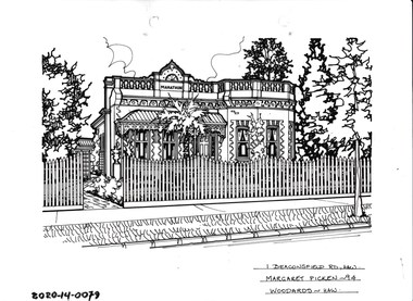 Hawthorn Historical Society
Drawing - Property Illustration, 1 Beaconsfield Road, Hawthorn
... range of real estate agents in Melbourne between c. 1983 and c. 2006. Each work is signed and dated by the artist. The series of property illustrations in the Picken Collection are invaluable assets for identifying architectural styles and features. The year in which the drawing was created is also a valuable record for house historians, as a number of the properties depicted have either been altered since that date or demolished. artist - margaret picken 1950- 1 Beaconsfield Road, Hawthorn, Margaret Picken '94. ...'After training as a Cartographic Draftsman within the mining industry, I worked as a property illustrator for real estate firms in the eastern suburbs of Melbourne for 23 years from 1983. I initially photographed houses with a Polaroid camera and made a 'thumbnail' sketch while there. The photos were used to scale off a sketch in pencil and then that sketch was overlaid with drafting film and the 'pen and ink' completed. The pens I used were the Rotring ‘Rapidigraph’ drafting pens. The ink was also made by Rotring (German).The film was ‘Rapidraw’, polyester drafting film, double matte. It takes a very fine line and doesn’t bleed. As well as house sketches, there were often floor plans and site plans ordered. Aerial sketches were ordered when the property needed an overall view.' (Margaret Picken, 2020)This property illustration is one of a series created by Margaret Picken for a range of real estate agents in Melbourne between c. 1983 and c. 2006. Each work is signed and dated by the artist.Gift of Margaret Picken, 2020Pen and ink property illustration on drafting film of 1 Beaconsfield Road, Hawthorn by Margaret Picken.1 Beaconsfield Road, Hawthorn, Margaret Picken '94. Woodards - Hawthorn.artist - margaret picken 1950- -
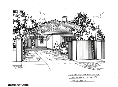 Hawthorn Historical Society
Drawing - Property Illustration, 22 Beaconsfield Road, Hawthorn
... range of real estate agents in Melbourne between c. 1983 and c. 2006. Each work is signed and dated by the artist. The series of property illustrations in the Picken Collection are invaluable assets for identifying architectural styles and features. The year in which the drawing was created is also a valuable record for house historians, as a number of the properties depicted have either been altered since that date or demolished. artist - margaret picken 1950- 22 Beaconsfield Road, Haw E, Margaret Picken '93. ...'After training as a Cartographic Draftsman within the mining industry, I worked as a property illustrator for real estate firms in the eastern suburbs of Melbourne for 23 years from 1983. I initially photographed houses with a Polaroid camera and made a 'thumbnail' sketch while there. The photos were used to scale off a sketch in pencil and then that sketch was overlaid with drafting film and the 'pen and ink' completed. The pens I used were the Rotring ‘Rapidigraph’ drafting pens. The ink was also made by Rotring (German).The film was ‘Rapidraw’, polyester drafting film, double matte. It takes a very fine line and doesn’t bleed. As well as house sketches, there were often floor plans and site plans ordered. Aerial sketches were ordered when the property needed an overall view.' (Margaret Picken, 2020)This property illustration is one of a series created by Margaret Picken for a range of real estate agents in Melbourne between c. 1983 and c. 2006. Each work is signed and dated by the artist.Gift of Margaret Picken, 2020Pen and ink property illustration on drafting film of 22 Beaconsfield Road, Hawthorn by Margaret Picken.22 Beaconsfield Road, Haw E, Margaret Picken '93. Woodards - Hawthorn.artist - margaret picken 1950-