Showing 5016 items matching "belgrave road"
-
 Ringwood and District Historical Society
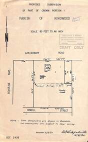
Map, Proposed Subdivision - Part of Crown Portion 1, Parish of Ringwood, Canterbury Road, east of Belgrave Road, Ringwood. 1963
... Proposed Subdivision - Part of Crown Portion 1, Parish of Ringwood, Canterbury Road, east of Belgrave Road, Ringwood. 1963....Proposed Subdivision - Part of Crown Portion 1, Parish of Ringwood, Canterbury Road, east of Belgrave Road, Ringwood. 1963. Map ...Diagram showing layout of property fronting Canterbury Road and backing onto Orwell Street, later Shortland Street, Ringwood. Rubber stamped Kirkpatrick & Webber, Surveyors, Engineers & Town Planners, 225 Maroondah Highway Ringwood, Telephone 870-0321. "Draft Only". Allotment 1 includes location of weatherboard house and sheds, and proposed drainage and sewerage easement. Note:- Title dimensions are shown in brackets. Lot dimensions are subject to final survey. Signed by D. Kirkpatrick, 16/8/1963. Amended 21/8/1963. -
 Southern Sherbrooke Historical Society Inc.
Photograph, A Bend In The Road, Belgrave, c. 1920s
... A Bend In The Road, Belgrave...Photo shows a bend in the road, Belgrave, most likely on Monbulk Road below Sherbrooke Forest. ...A Bend In The Road, Belgrave Photograph ...Photo shows a bend in the road, Belgrave, most likely on Monbulk Road below Sherbrooke Forest. An unmade road crosses a small gully. A group of three or so young people are leaning over the bridge railing. The area is heavily treed. A BEND IN THE ROAD hand-wriiten in ink below the photo on the album page -
 Southern Sherbrooke Historical Society Inc.
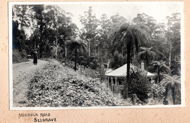
Photograph, Monbulk Road, Belgrave
... Monbulk Road, Belgrave...Road from Belgrave to Monbulk. A woman stands on the road holding a stick. ...There is smoke coming from a chimney which may be on the visible house or from one behind. c.1920. Monbulk Road, Belgrave Photograph ...Road from Belgrave to Monbulk. A woman stands on the road holding a stick. There is a creeper growing on the verge. Tall treeferns surround a house on the right side, below the road. The house has a verandah extending all the way around. There is smoke coming from a chimney which may be on the visible house or from one behind. c.1920. -
 Emerald Museum & Nobelius Heritage Park
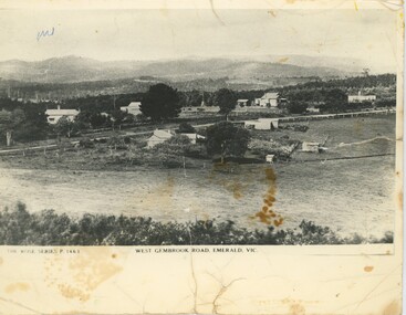
Postcard - Postcard of West Gembrook Road, Emerald, Rose Stereograph Company, West Gembrook Road, Emerald, Vic, Circa 1930s-45
... It depicts 'West Gembrook Road' - likely now Old Gembrook Road or Belgrave-Gembrook Road - surrounded by fields on one side and small home on the other. ...Belgrave-Gembrook Road?, Emerald, Victoria, Australia...It depicts 'West Gembrook Road' - likely now Old Gembrook Road or Belgrave-Gembrook Road - surrounded by fields on one side and small home on the other. ...This photograph was taken as a postcard in the Rose Stereograph Company's Rose Series. It was number P. 1463 in the series, meaning it was likely taken in the 1930s or early 40s. It depicts 'West Gembrook Road' - likely now Old Gembrook Road or Belgrave-Gembrook Road - surrounded by fields on one side and small home on the other. Over 14000 Rose Series postcards were produced over the lifetime of the Company, capturing everything from major landmarks to quiet scenic roads like this. It may have been taken by Karl Visser.The photograph depicts part of Emerald as it was in the 1930s. At the time, it was considered representative of the area, enough to be published as a postcard.Black and white photograph (copy) on gloss photographic paper. Below the photo is a label describing its location and denoting it as part of the Rose Series. The photo looks down at a road with hills in the background, a field in the foreground and occasional building along the roadside. The rear has writing in pencil and some pen scribbles, and there is a pen scribble on the upper left of the photograph.Front, Left, Below Photograph: "THE ROSE SERIES P. 1463" Front, Centre, Below Photograph: "WEST GEMBROOK ROAD, EMERALD, VIC." Rear: "KAPL VISSER / 600 511"emerald, photography, 1930s, 1940s -
 Save the Dandenongs League Inc.
Archive (item), Save the Dandenongs League Incorporated, SDL [Objection to development at 32 Monbulk Road, Belgrave]
... SDL [Objection to development at 32 Monbulk Road, Belgrave]...SDL [Objection to development at 32 Monbulk Road, Belgrave] Archive Save the Dandenongs League Incorporated ... -
 Southern Sherbrooke Historical Society Inc.
Postcard - Postcard-original-Swans Bend Belgrave, Vic. c.1940s, A Bend In The Road, Belgrave
... A Bend In The Road, Belgrave...Belgrave Township from the west. Later known as Swans Corner. Dr Shirley Francis's house in centre of photo. Photo shows a hillside with three houses above the road. ...A Bend In The Road, Belgrave Postcard Postcard-original-Swans Bend Belgrave, Vic. c.1940s ...Sepia-toned postcard featuring bend coming into Belgrave Township from the west. Later known as Swans Corner. Dr Shirley Francis's house in centre of photo. Photo shows a hillside with three houses above the road. A man walks along the lower side of the road. c. 1920s. -
 Southern Sherbrooke Historical Society Inc.
Photograph, Monbulk Road, Belgrave
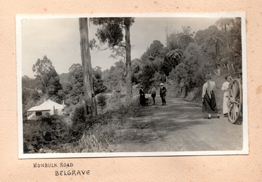
... Monbulk Road, Belgrave...Groups of people are standing on Monbulk Road, up from Belgrave. In the background are four women abreast walking away. ...Another building is visible in the distance. Monbulk Road, Belgrave Photograph ...Groups of people are standing on Monbulk Road, up from Belgrave. In the background are four women abreast walking away. There are two men, a young boy and a woman standing together in the middle ground and two younger women closer to the camera, standing beside a cart (with only a large cartwheel visible). There may be another man speaking to them. There is a path going up the hill to the right, with fence posts on the high side and a closed gate at the top. On the left of the photo there is a house below the road. There are two water tanks which look new. It may be the same house as appears in other photos in this collection. Another building is visible in the distance. -
 Southern Sherbrooke Historical Society Inc.
Photograph, Monbulk Road, Belgrave
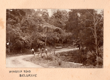
... Monbulk Road, Belgrave...Group of four people standing on Monbulk Road just out of Belgrave. Possibly Beauty Bend. Holiday makers, all well dressed. ...A house roof is just visible beyond the bush. c.1920. Monbulk Road, Belgrave Photograph ...Group of four people standing on Monbulk Road just out of Belgrave. Possibly Beauty Bend. Holiday makers, all well dressed. There is a wooden seat on the left side of road. There is a gully on the right side. The left side has heavy bush. A house roof is just visible beyond the bush. c.1920. -
 Southern Sherbrooke Historical Society Inc.
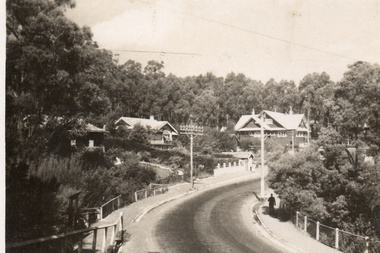
Photograph, Main Road, Belgrave
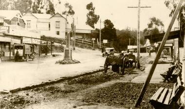
... Main Road, Belgrave...Belgrave. Coffee Palace is left of centre on side of Terrys Avenue. Cenotaph is in centre of road in front of shops, where Morson Court now stands. ...Motors visible on right hand side. Main Road, Belgrave Photograph ...Early photo of the Main St, Belgrave. Coffee Palace is left of centre on side of Terrys Avenue. Cenotaph is in centre of road in front of shops, where Morson Court now stands. Men with horse and carts appear to be working on the road or footpath. Site of U. S. Motors visible on right hand side. -
 Southern Sherbrooke Historical Society Inc.
Photograph - Main Road, Belgrave, early 1950s
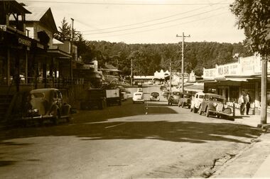
... Main Road, Belgrave, early 1950s...Belgrave Main Street around early 1950's. Chemist would have been Mr. Brent. Forest Frocks was run by Mr. Buchanan. U.S. Motors visible at end of street on right; bus stop there. Guest house on left hand side corner of Terrys Avenue. Street is busy. Photograph Main Road ...Belgrave Main Street around early 1950's. Chemist would have been Mr. Brent. Forest Frocks was run by Mr. Buchanan. U.S. Motors visible at end of street on right; bus stop there. Guest house on left hand side corner of Terrys Avenue. Street is busy. -
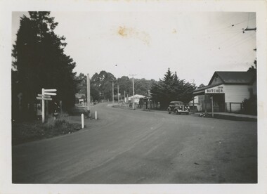 Emerald Museum & Nobelius Heritage Park
Photograph - Emerald Township 1948, March 1948
... This particular thoroughfare connecting Belgrave-Gembrook Road and Emerald-Monbulk Road, now home to many local and major business, has changed greatly over the last century. ...Belgrave-Gembrook Road, Emerald, Victoria, Australia...This particular thoroughfare connecting Belgrave-Gembrook Road and Emerald-Monbulk Road, now home to many local and major business, has changed greatly over the last century. ...This particular thoroughfare connecting Belgrave-Gembrook Road and Emerald-Monbulk Road, now home to many local and major business, has changed greatly over the last century. This dirt road was once home to the first Emerald butcher, established by Robert John Couper around 1900. Located on the corner of Main Street and Monbulk Road, the butcher was first run out of Couper's home, then it moved into a shop built on their property and customers were most often served by his wife Mabel. The butcher was then purchased by the Madigan Family in 1924 and run by Timothy James Madigan following his return from World War One service. Animals were slaughtered on-site, then stored in an underground cellar. Meat was then purchased in the store-front or delivered to local towns and homes by horse-drawn carriage and, eventually, delivery vans.This photograph demonstrates with incredible clarity just how greatly the local Emerald township has changed over the last century, especially on a thoroughfare as central as the one pictured.This black and white photograph features a dirt street lined with trees and buildings. On the left, a street sign points to locations such as Lilydale, Monbulk, Gembrook, Ferntree Gully, Macclesfield, and Melbourne. Two women stand behind the sign, waiting to cross the road. A butcher stands on the right side of the street and car is parked out front. Telephone poles are dotted along the road, both disappearing around a corner and into a horizon of trees. On the photograph's reverse is some handwritten text.Rear, handwritten in ink: "Emerald. / Mar. 1948."1940s, emerald, madigan family -
Glen Eira Historical Society
Letter - HUNT, WILLIAM HOGARTH
... ... Belgrave Road...' House names Belgrave Road Dandenong Road Hunter 'Pud' Police officers Hunt Jess Kangaroo Road Murrumbeena Glen Huntly Letter HUNT, WILLIAM HOGARTH ...Two sets of this man's handwritten memories: 1/Five pages of handwritten personal memories, written by William Hogarth Hunt 13/07/1977. He outlines his family, their travels and settlement in 1908 at Glenhuntly: a detailed account of residents, shop owners, land sales and identities, Murray Ross, Mr Burr of Burr’s Gun Oil and Mr Zarman. Also details Glenhuntly Methodist Church, football, athletics, Glenhuntly Aerodrome and an extensive list of local residents and their stories. 2/Two pages of handwritten personal memories, written by William Hogarth Hunt 02/09/1977. A detailed account of residents, shop owners, identities, athletes, local policemen and their stories in the Glen Huntly area.personal memories, hunt william hogarth, glenhuntly, grange road, trams, plumber, stone mary ann, neerim road, wanalta road, schurme mrs, private hospital, hospitals, watson grove, hunt jessie, hunt alfred, hunt charles, smith mr, fisher mr, smith mrs, jockeys, dore george, ‘willis’, builders, house names, mernda, roseberry grove, el nido, neerim road, glenhuntly post office, mrs fielder’s sweetshop, mrs beer’s sweet shop, paddocks, confectionery, fielder fred, maroona road, murrumbeena, grocers, callister dave, carnegie state school, hay and corn store, james street, woodyard, hillards chemist, hughes body works, chemists, davidson’s, glenhuntly printing, hay and corn stores, railway gates, anz bank, fox mr, martin jack, fox mrs, clothing stores, steam rollers, radio and tv shop, beasley j, delicatessen/ham and beef shop, butchers, schurme’s private hospital, gellatley george, tailors, commonwealth banks, watson grove, banks, preston peter, e.j. & h. amos, hardware stores, estate agents, glenhuntly picture theatre, whittle mr, theatres, newsagency, cooper and cooke, station street, f.j. long and co, jennings a.v, timber yards, builders, ‘the estate’, hillcrest estate, grange road, marara road, rosedale avenue, hobart jack, mackie road, confectionery stores, ross murray, glenhuntly athletic club, godfrey evelyn, athletics clubs, railways, glenhuntly junior football club, elsternwick, princess park, carnegie oval, booran road, koornang park, ormond oval – ee. gunn reserve, glenhuntly oval, oakleigh road, victorian amateur turf club, koornang road, glenhuntly aerodrome, neville street, glenhuntly state school, rosslyn street, geary mr, lauriston tennis courts, bakers, carnegie r.s.l., east bentleigh, bowling clubs, tucker road, tennis clubs, centre road, murrumbeena road, larman mr, hollway street, nurseries, parker street, lyle marshall, burr mr, solicitors, builders, bones nursery, ‘burr’s gunoil’, glenhuntly methodist church, carnegie, smith alf, ezard family, clemens family, noy family, noy clarrie, dickie family, storey family, storey george, davis family, joss house, chinese community, wattle avenue, grange road, glenhuntly amateur football club, football clubs, glenhuntly athletic club, athletic clubs, glen huntly junior football club, carnegie oval, koornang park, glenhuntly oval, victorian amateur turf club, glenhuntly aerodome, glenhuntly state school, geary mr., bakers, east bentleigh, tucker road, centre road, larman mr, nurseries, lyle marshall, solicitors, bones nursery, carnegie, "the estate", royal avenue, mckay avenue, dumsday bertha miss, love family, gilmour family, waratah ave, sinclair mr, tuckpointers, bricks, donegan mr, plumbers, frazer mr, frazer and jenkinson printers, frazer arthur, ezard manufacturing, jewellers, private hospital, maroona road, o'carroll mr, beattie mr, horse trainer, morton tom, lord harry, estate agents, ormond, councillors, taylor mr, builders, gibson family, westley alf, o'carroll j (jack) d, glenhuntly athletics club, athletes, jack page's bakery and cake shop, nay clarrie, hunt william h., hunt alf, page jack, armstrong jack, manchester grove, morgan advertising, cusdin sid, farrier, glenhuntly cricket club, caulfield racecourse, neerim road, hoffman's plumbing, emma street, st. agnes school, st. agnes church hall, jenkin 'boss' mr, teachers, hawthorn miss, quinn miss, chitty charlie, chitty's timber, crystal palace picture theatre, theatres, marsh bill, hardware shops, watson arthur w, j.s. kidd and company, marshes hardware, kidd's hardware, bruce ivy, 'belgrave', house names, belgrave road, dandenong road, hunter 'pud', police officers, hunt jess, kangaroo road, murrumbeena, glen huntly -
Glen Eira Historical Society
Document - St Giles Presbyterian Church, Murrumbeena
... ... Belgrave Road...Dandenong Road Belgrave Road Murrumbeena Harwood C. Oakleigh Carnegie Circuit Sunday schools Murrumbeena Methodist Men’s Movement Hartley F. ...One item about the history of this Church for later period: Two copies of the booklet ST GILES 1890 TO 1990, ONE HUNDRED YEARS IN MURRUMBEENA, dated 15/07/1990 by St Giles Publicity Committee, includes photographs.st giles presbyterian church, murrumbeena presbyterian church, murrumbeena methodist church, ministers, sunday schools, uniting church, armstrong w. j., armstrong w. j. mrs., secomb w. e. rev., andrews mr., crabtree mr., hocking mr., hocking mrs., dandenong road, belgrave road, murrumbeena, harwood c., oakleigh carnegie circuit, sunday schools, murrumbeena methodist men’s movement, hartley f. rev., orton j. russell rev., manzoney w. s. rev., shotton h. t. rev., eldridge l. b. rev., wilcock s. c. rev., bye r. rev., slattery k. rev., archbold b. rev., sunderland h. rev., blanksby a., mcdonald n., porritt d., lukies j., reid g., orton a., reid g., orton a., reid pris, reid will, pollock lex rev., pollock mabel, evans derek rev., mclean colin rev., denholm robin rev., mcrae dick, elmore frank rev., tara grove, brown robert rev., murrumbeena, murrumbeena road, church groups -
 Glen Eira Historical Society
Document - Methodist Church, Murrumbeena Road, Murrumbeena
... ... Belgrave Road...Rev Dandenong Road Belgrave Road Harwood C. Tally Ho Auxiliary Women’s Auxiliary Murrumbeena Men’s Methodist movement Methodist Men’s Society Hartley F. ...Five items about this church. 1.Detailed inscription of foundation stone. 2.Photograph, date unknown. 3.Pamphlet of Inaugural Service Diamond Jubilee Celebration 1912 to 1972. 4.Information on the window installed by Mrs Agnes M Beck. 5.A photocopy of a typed document titled ‘The Methodist Heritage of the Murrumbeena Uniting Church’.daws c.k. rev, cain j.h. rev, johns w. rev, blakemore john rev, foundationstones, white h.g builder, murrumbeena, methodist church, st giles presbyterian, festivals and celebrations, architect browning and bladen, delascombe rohan sir, murrumbeena road, delacombe lady, fox mrs, fox emc mhr, scanlon a mr mla, arden f.a. mrs, moran mrs, moran b mr, moyors, councillors, town clerks, beck agnes m mrs, windows, monuments and memorials, doble allan, brown bob rev, presbyterian church, inglis robert mr, mcdonald hall, parish magazine ‘encounter’, reid jack, arden f.a, kindergartens, religious groups, fusion, demmler pty ltd, mcdonald hall, pollock lex. rev, plaques, bruce mrs, monkhouse mrs, holbern mrs, ladies league, sunderland h. rev, armstrong w.j., secomb w.e. rev, dandenong road, belgrave road, harwood c., tally ho auxiliary, women’s auxiliary, murrumbeena men’s methodist movement, methodist men’s society, hartley f. rev, manzoney w.s. rev, sholton h.t rev, eldridge l.b rev, wilcock s.c rev, bye r. rev, slattery k. rev, archbold b. rev, sunderland h. rev, blanksby a. rev, mcdonald n. rev, porrih d. rev, lukies j. rev, reid g. rev, orton a. rev, young men’s club, methodist babies home, assisted migrant scheme, harris l.b., reid pris, reid will, davey eric, field jack, st giles centenary, encounter no.2. 1990, encounter no.3. 1991, mcdonald edua, don anne -
Glen Eira Historical Society
Caulfield Central Presbyterian Church, St. Giles
... ...Belgrave Road...Dandenong Road Belgrave Road Murrumbeena Harwood C. Oakleigh Carnegie Circuit Sunday schools Murrumbeena Methodist Men’s Movement Hartley F. ...Two copies of the booklet ST GILES 1890 TO 1990, ONE HUNDRED YEARS IN MURRUMBEENA, dated 15/07/1990 by St Giles Publicity Committee, includes photographs., Two printed pages of lists of names of church ministers and other officials from 1890 to 1990.st giles presbyterian church, murrumbeena presbyterian church, murrumbeena methodist church, ministers, sunday schools, uniting church, armstrong, w. j., armstrong, w. j. mrs., secomb, w. e. rev., andrews, mr., crabtree, mr., hocking, mr., hocking, mrs., dandenong road, belgrave road, murrumbeena, harwood, c., oakleigh carnegie circuit, sunday schools, murrumbeena methodist men’s movement, hartley, f. rev., orton, j. russell, rev., manzoney, w. s. rev., shotton, h. t. rev., eldridge, l. b. rev., wilcock, s. c. rev., bye, r. rev., slattery, k. rev., archbold, b. rev., sunderland, h. rev., blanksby, a., mcdonald, n., porritt, d., lukies, j., reid, g., orton, a., reid, g., orton, a., reid, pris, reid, will, pollock, lex, rev., pollock, mabel, evans, derek, rev., mclean, colin, rev., denholm, robin, rev., mcrae, dick, elmore, frank, rev., tara grove, brown, robert, rev., murrumbeena, murrumbeena road, church groups -
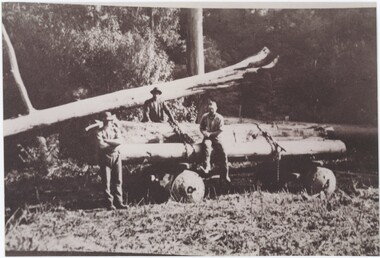 Emerald Museum & Nobelius Heritage Park
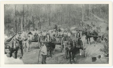
Photograph - George A'Vard at Red Mill, c. 1925-1940
... The photo is said to have been taken at the Red Mill, which is on 62 Monbulk Road, Belgrave and opened in 1925 as the Belgrave Kiosk and Dance Palais. ...62 Monbulk Road, Belgrave, Victoria, Australia...The photo is said to have been taken at the Red Mill, which is on 62 Monbulk Road, Belgrave and opened in 1925 as the Belgrave Kiosk and Dance Palais. ...George W A'Vard (1890-1966) was a long-time resident of the area, known for his bullock team. That team may be off-camera in this photograph, preparing to pull the wagon of logs pictured. His business was operational by 1913, but it is unclear precisely when this photo was taken. The photo is said to have been taken at the Red Mill, which is on 62 Monbulk Road, Belgrave and opened in 1925 as the Belgrave Kiosk and Dance Palais. This is a photograph of a notable Emerald resident, capturing early 20th century transportation methods.This item is a printed black and white photograph on modern photo paper. The reverse features Kodak logos and a handwritten annotation. The photograph shows three men standing or leaning on a 4-wheeled wagon. The wagon is flat, with logs piled on top and tied down by two ropes. The foreground shows flat ground, while there are trees filling the background. Reverse, Handwritten Annotation: "George A'Vard Red mill"red mill, belgrave, 1920s -
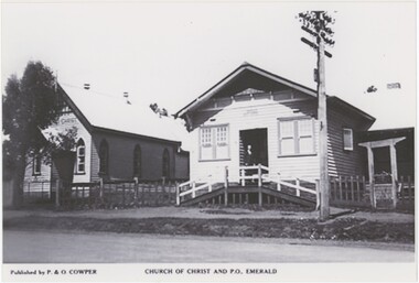 Emerald Museum & Nobelius Heritage Park
Photograph, P. & O. Cowper, Church of Christ and P.O. Emerald, c. Mid 20th Century
... 352 Belgrave-Gembrook Road, Emerald, Victoria, Australia ..."P. & O. Cowper" does not appear in internet research as a known publishing company; it is possible either that none of their work has made its way online, or that they were locals publishing on a small scale capacity. If the latter is true, "P. Cowper" could have been Mr. P. Cowper who participated in forming the Emerald Co-operative Society in 1945. The Emerald Church of Christ operated from 1913 until 1964 on the site (and building) now part of Fernlea Community House. The old post office was on that location from the 1910s until after the Church stopped operating, although by the 1960s there were telephone booths in front of the post office. This image could date from 1913 until the 1950s, although it is likely toward the later end of that range in the 1940s or 50s. This copy was produced in 2006 from the original.This photograph captures two long-standing Emerald institutions from the first half of the 20th century, one of which is no longer in operation and the other which has moved and had its place replaced with an unrecognisable new structure.This black and white photograph is printed on glossy modern photo paper. Its lower margin is occupied by printed text explaining the publisher and the subject matter. The photograph itself centres on two buildings, each constructed from wooden planks with sloped, likely tin rooves. A power pole stands to the right in front of the rightmost building. The ege of a road is visible in the foreground, indicating that this picture was taken from on or across the road. The reverse has printed technical information about the photograph, typical of a digital printed photograph.Obverse: Left, Typed: "Published by P. & O. COWPER" Centre, Typed: "CHURCH OF CHRIST AND P.O. EMERALD" Sign in Image, Left: "[obscured] CHRIST" Reverse: "10 27 PCEMER~4.JPG 6 16.12.06 18.12.06"emerald, 1940s, 1950s, emerald post office, emerald church of christ -
 Ringwood and District Historical Society
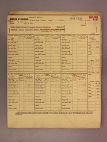
Administrative record - Rate Books, Borough of Ringwood Valuation & Rate Cards for 1944-49 (Assessments 3193-3197), March 2012
... For BR Stewart (Belgrave Road), Violet Sampson (Barkly Street), Margaret Cowin (Barkly Street), Edith Phillips (Barkly Street) & Arthur George (Barkly Street, Allman's Estate)....Only source of ratepayers in the Borough of Ringwood For BR Stewart (Belgrave Road), Violet Sampson (Barkly Street), Margaret Cowin (Barkly Street), Edith Phillips (Barkly Street) & Arthur George (Barkly Street, Allman's Estate). ...Originally stored at Ringwood Council offices, then taken to PROV.Only source of ratepayers in the Borough of RingwoodDigital imagesFor BR Stewart (Belgrave Road), Violet Sampson (Barkly Street), Margaret Cowin (Barkly Street), Edith Phillips (Barkly Street) & Arthur George (Barkly Street, Allman's Estate). -
 Emerald Museum & Nobelius Heritage Park
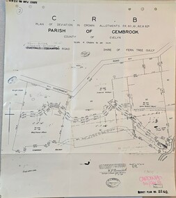
Map - Plan of deviation in Crown Allotments - parish of Gembrook, Gembrook-Belgrave Rd, Alterations to allotments 59, 60, 61,62 & 62A for the formation of Belgrave-Gembrook Rd., 1929, c1929
... CRB/Plan of deviation in Crown Allotments 59, 60, 61, 62 & 62A/Parish of Gembrook, County of Evelyn/Scale 4 chains to an inch/Gembrook-Belgrave Road/certification of plan (signed) WP BONWICK, Surveyor Licensed under Act 2679/5-2-29/Survey Plan 2240...Emerald Museum & Nobelius Heritage Park 5 Crichton Rd Emerald yarra-valley-and-the-dandenong-ranges CRB/Plan of deviation in Crown Allotments 59, 60, 61, 62 & 62A/Parish of Gembrook, County of Evelyn/Scale 4 chains to an inch/Gembrook-Belgrave Road/certification of plan (signed) WP BONWICK, Surveyor Licensed under Act 2679/5-2-29/Survey Plan 2240 Image of Plan of deviation in Crown Allotments - parish of Gembrook, Gembrook-Belgrave Rd., allotments 59, 60, 61,62 & 62A Alterations to allotments 59, 60, 61,62 & 62A for the formation of Belgrave-Gembrook Rd., 1929 Map Plan of deviation in Crown Allotments - parish of Gembrook, Gembrook-Belgrave Rd., ...Image of Plan of deviation in Crown Allotments - parish of Gembrook, Gembrook-Belgrave Rd., allotments 59, 60, 61,62 & 62ACRB/Plan of deviation in Crown Allotments 59, 60, 61, 62 & 62A/Parish of Gembrook, County of Evelyn/Scale 4 chains to an inch/Gembrook-Belgrave Road/certification of plan (signed) WP BONWICK, Surveyor Licensed under Act 2679/5-2-29/Survey Plan 2240 -
Southern Sherbrooke Historical Society Inc.
Information folder - Belgrave Heights Convention Ground
... Contents: -map, "Belgrave District Road Map" showing locations in Belgrave Heights & South -map "Belgrave Heights Road Map" showing Convention Grounds, buildings and other local sites -Various items photocopied on single sheet, inc. token for Gospel Supplies, Belgrave Heights; item re. ...Contents: -map, "Belgrave District Road Map" showing locations in Belgrave Heights & South -map "Belgrave Heights Road Map" showing Convention Grounds, buildings and other local sites -Various items photocopied on single sheet, inc. token for Gospel Supplies, Belgrave Heights; item re. ...Information folder containing items pertaining to the history of the Belgrave Heights Convention Grounds. Contents: -map, "Belgrave District Road Map" showing locations in Belgrave Heights & South -map "Belgrave Heights Road Map" showing Convention Grounds, buildings and other local sites -Various items photocopied on single sheet, inc. token for Gospel Supplies, Belgrave Heights; item re. Rudi Atwood, minister; list of hymns; photo of Main St, Belgrave. -
 Southern Sherbrooke Historical Society Inc.
Photograph - Looking along the Crescent
... Photograph of a road, looking along The Crescent, Belgrave Heights. Road is lined by trees and shrubbery, with the taller ones on the left hand side. ...Southern Sherbrooke Historical Society Inc. 127 Colby Drive Belgrave Heights 3160 yarra-valley-and-the-dandenong-ranges Photograph of a road, looking along The Crescent, Belgrave Heights. ...Photograph of a road, looking along The Crescent, Belgrave Heights. Road is lined by trees and shrubbery, with the taller ones on the left hand side. Probably taken by Betty de Coite nee Woods or her parents. -
 Southern Sherbrooke Historical Society Inc.
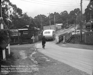
Photograph, Belgrave Railway Bridge, 1947
... It shows a bus crossing the bridge onto (now) Belgrave-Gembrook Road, followed by a male cyclist wearing a dark overcoat and bowler hat. ...It shows a bus crossing the bridge onto (now) Belgrave-Gembrook Road, followed by a male cyclist wearing a dark overcoat and bowler hat. ...Belgrave railway bridge looking towards Bayview Road from Terrys Ave, 1947. It shows a bus crossing the bridge onto (now) Belgrave-Gembrook Road, followed by a male cyclist wearing a dark overcoat and bowler hat. A man wearing a homburg hat is crossing the footbridge beside the main bridge towards the main street. There is a pale van parked (or driving past) a dairy on the corner of Bayview Rd and Belgrave-Gembrook Road. A brick toilet block is shown with a sign saying 'MEN' on a nearby lamp post. -
 Emerald Museum & Nobelius Heritage Park
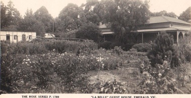
Photograph/postcard, 'La Belle' Guest House, Emerald, Vic, c 1940's
... The guest house was on Belgrave/Gembrook Road between IGA and the Shell Petrol Station. ...The guest house was on Belgrave/Gembrook Road between IGA and the Shell Petrol Station. ...Tim Kennedy built 'La Belle' Guest House circa 1890 - 1920. It became 'The Grange' sometime after 1942. The guest house was on Belgrave/Gembrook Road between IGA and the Shell Petrol Station. Unfortunately the guest house was demolished around 1983.Guest houses of the DandenongsSepia postcard, Rose Series depicting early guest house in EmeraldFront: The Rose Series Postcard, 'La Belle' Guest House, Emerald Vic. Back:: (handwritten) Dear Miss Hartnell, Just to wish you a Happy Xmas and bright new year I hope and trust that your health is better it was just twelve months yesterday since I returned from Olinda how time flies Doesent it, with all good wishes yours sincerely B George'la belle', the grange, tim kennedy -
 Southern Sherbrooke Historical Society Inc.
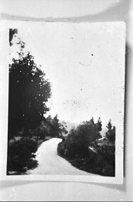
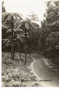
Postcard, The Monbulk Rd, Belgrave
... Sepia-toned postcard featuring Monbulk Road, Belgrave, presumably heading towards Kallista. ...Southern Sherbrooke Historical Society Inc. 127 Colby Drive Belgrave Heights 3160 yarra-valley-and-the-dandenong-ranges Sepia-toned postcard featuring Monbulk Road, Belgrave, presumably heading towards Kallista. ...Sepia-toned postcard featuring Monbulk Road, Belgrave, presumably heading towards Kallista. Very tall fern trees on left side of road. Road not made. -
 Southern Sherbrooke Historical Society Inc.
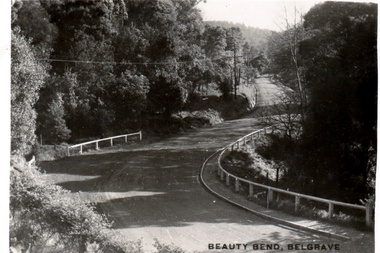
Postcard - Postcard-original-Beauty Bend, Belgrave, Vic. c. early 1930s, Beauty Bend
... Sepia-toned postcard featuring Beauty Bend just outside Belgrave Township on Monbulk Road. There is heavy bush to either side. ...Southern Sherbrooke Historical Society Inc. 127 Colby Drive Belgrave Heights 3160 yarra-valley-and-the-dandenong-ranges Sepia-toned postcard featuring Beauty Bend just outside Belgrave Township on Monbulk Road. There is heavy bush to either side. ...Sepia-toned postcard featuring Beauty Bend just outside Belgrave Township on Monbulk Road. There is heavy bush to either side. A house is in the distance. -
 Southern Sherbrooke Historical Society Inc.
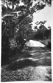
Photograph - Bush track at Belgrave Heights
... Photograph of a bush road at Belgrave Heights, Lockwood Rd. Heavily treed on the left side. ...Southern Sherbrooke Historical Society Inc. 127 Colby Drive Belgrave Heights 3160 yarra-valley-and-the-dandenong-ranges Photograph of a bush road at Belgrave Heights, Lockwood Rd. ...Photograph of a bush road at Belgrave Heights, Lockwood Rd. Heavily treed on the left side. Probably taken by Betty de Coite nee Woods or her parents. -
 Emerald Museum & Nobelius Heritage Park
Photograph, Mr O'Connor, Making the Road to Clematis, c. 1920
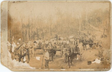
... In late 1919, the Country Roads Board approved an amendment of the Belgrave-Emerald Road between Gembrook Road (likely now Old Gembrook Road) in Emerald and Paradise (now Clematis) Station. ...Emerald Museum & Nobelius Heritage Park 5 Crichton Rd Emerald yarra-valley-and-the-dandenong-ranges In late 1919, the Country Roads Board approved an amendment of the Belgrave-Emerald Road between Gembrook Road (likely now Old Gembrook Road) in Emerald and Paradise (now Clematis) Station. ...In late 1919, the Country Roads Board approved an amendment of the Belgrave-Emerald Road between Gembrook Road (likely now Old Gembrook Road) in Emerald and Paradise (now Clematis) Station. This image shows part of those works, where they intersected with Ogilvy Road. Public works projects such as road constructions were popular in the immediate aftermath of the First World War, when many men returned home without work and were eager to earn a living by participating in government projects.This image represents an infrastructure project from the 1920s that helped to build the Emerald of today. It displays the tools and technology available for public works projects in the early 20th century, and the manner in which road construction occurred.A sepia photograph on card backing depicting a road construction project. The workers are relying on horses and manual labour to build a road amongst trees and hills. The lower-left corner of the photograph is damaged and faded, with some damage and the photo peeling away from the backing along the left side as a whole. The rear has some handwritten text, with some illegible.Rear: "Mr O'Connor / 12 / date / Clematis / Making the Road to Clematis / 1920?"emerald, clematis, 1920s, transport -
 Emerald Museum & Nobelius Heritage Park
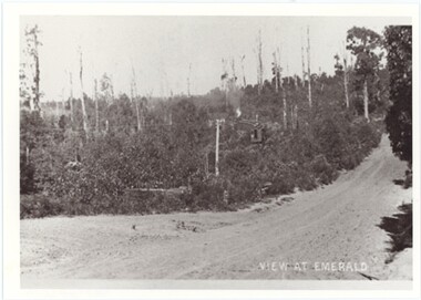
Photograph, View at Emerald, 1900-1954
... Location-wise, given the proximity to the railway it was likely taken from Belgrave-Gembrook Road to the west of Emerald, looking towards the town, though it is unclear exactly where this could have happened. ...Location-wise, given the proximity to the railway it was likely taken from Belgrave-Gembrook Road to the west of Emerald, looking towards the town, though it is unclear exactly where this could have happened. ...It's difficult to tell exactly when this photograph was taken, besides that it was when the line which is now Puffing Billy was in operation - that is, between 1900 and 1954. Location-wise, given the proximity to the railway it was likely taken from Belgrave-Gembrook Road to the west of Emerald, looking towards the town, though it is unclear exactly where this could have happened. This could also be taken from one of the curves in then railway to the east of Emerald, though the roads it could be taken from were historically limited.This photograph shows an earlier view of Emerald and its surroundings, mostly lacking the development that has effected the land over the past centuries.This item is a modern copy of an older black and white photograph. It is relatively blurry and pixelated, indicating it may have been expanded from a smaller photograph. It depicts an unpaved road; the photographer is standing to the right of the road, looking down it as it approaches from behind the photographer, appears in the bottom-left, ascends a hill and disappears into the top-right of the photograph. Past the road is a landscape mostly of shrubs, bushes, and sparse trees, interrupted by an unclear train with several carriages following the line left, steam emitting from its chimney.. Alongside the road runs what looks like a telegraph line, though depending when this was taken it could carry electricity.Obverse, Caption: "VIEW AT EMERALD"emerald -
 Southern Sherbrooke Historical Society Inc.
Photograph - Chopping up a fallen tree just before Herman's Corner
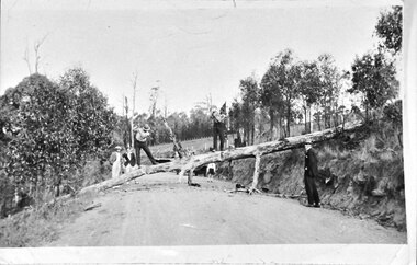
... A child stands further down the road, partially obscured by the tree. This is near Hermons Corner on the (now) Belgrave-Gembrook Road, Menzies Creek. ...A child stands further down the road, partially obscured by the tree. This is near Hermons Corner on the (now) Belgrave-Gembrook Road, Menzies Creek. ...Photo shows a tree lying across a road, having fallen from a high bank on the right. Two men are standing on the tree and appear to be cutting it with axes. Three other men are watching. A child stands further down the road, partially obscured by the tree. This is near Hermons Corner on the (now) Belgrave-Gembrook Road, Menzies Creek. The land on either side of the road is part of the Breen farm and the two axemen are the Breen brothers. -
 Emerald Museum & Nobelius Heritage Park
Photograph, Mr O'Connor, Making the Road to Clematis, Original Taken c. 1920
... In late 1919, the Country Roads Board approved an amendment of the Belgrave-Emerald Road between Gembrook Road (likely now Old Gembrook Road) in Emerald and Paradise (now Clematis) Station. ...Emerald Museum & Nobelius Heritage Park 5 Crichton Rd Emerald yarra-valley-and-the-dandenong-ranges In late 1919, the Country Roads Board approved an amendment of the Belgrave-Emerald Road between Gembrook Road (likely now Old Gembrook Road) in Emerald and Paradise (now Clematis) Station. ...In late 1919, the Country Roads Board approved an amendment of the Belgrave-Emerald Road between Gembrook Road (likely now Old Gembrook Road) in Emerald and Paradise (now Clematis) Station. This image shows part of those works, where they intersected with Ogilvy Road. Public works projects such as road constructions were popular in the immediate aftermath of the First World War, when many men returned home without work and were eager to earn a living by participating in government projects. This image is a black-and-white copy of the original sepia photograph (VEMUP0996).This image represents an infrastructure project from the 1920s that helped to build the Emerald of today. It displays the tools and technology available for public works projects in the early 20th century, and the manner in which road construction occurred.A black and white photograph on paper depicting a road construction project. The workers are relying on horses and manual labour to build a road amongst trees and hills. The lower-left corner of the photograph is faded - an artefact from the original that this is a copy of, though this copy was made when more of the original was intact.N/Aemerald, clematis, 1920s, transport