Showing 576 items matching "bennett street"
-
 Stawell Historical Society Inc
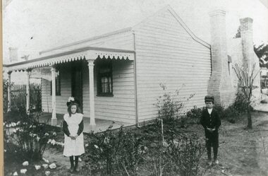
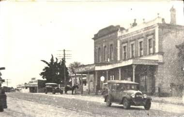
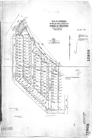
Photograph, Home Lot 21 Willoughby AKA 18 Bennett Street Stawell
... Home Lot 21 Willoughby AKA 18 Bennett Street Stawell...Home Lot 21 Willoughby (18 Bennett Street)...Stawell Historical Society Inc 46 Longfield St Stawell grampians Home Lot 21 Willoughby (18 Bennett Street) Stawell Home Lot 21 Willoughby AKA 18 Bennett Street Stawell Photograph ...Home Lot 21 Willoughby (18 Bennett Street)stawell -
![Map, Plan of Town Allotments Bacchus Marsh [1873]](/media/collectors/5e461d8021ea67224c82f2a1/items/677a8ee7ab7bb47995c5573f/item-media/677a8fdeab7bb47995c55b56/item-fit-380x285.jpg?cb=6) Bacchus Marsh & District Historical Society
Bacchus Marsh & District Historical SocietyMap, Plan of Town Allotments Bacchus Marsh [1873]
... ...Bennett Street Bacchus Marsh...The sale of his estate included the substantial stone residence in Bennett Street which later became known as 'Stone Villa'. ...A single page paper map showing 30 blocks of land for sale around 1873 in the vicinity of Bennett Street and Lerderderg Street. Described in contemorary sources as a 'lithographed copy'. ...The sale of his estate included the substantial stone residence in Bennett Street which later became known as 'Stone Villa'. ...James Young was a prominent businessman, land owner and public figure in the early colonial period of Bacchus Marsh. After his death in 1871 land remaining from his estate in Bacchus Marsh was sold at auction in 1873. The sale of his estate included the substantial stone residence in Bennett Street which later became known as 'Stone Villa'. The sale of his land in 1873 was conducted by local auctioneer James Crook. 29 allotments were advertised for sale, although the plan for the sale indicated 30 allotments. The sale notice in the Bacchus Marsh Express of 11 October 1873 noted that the allotments were " in the very centre and heart of the most populous and business portion of the township, at the same time being the only remaining portion of the business block available for purchase by public sale, which fact intending purchasers should not lose sight of, as the opportunity cannot occur again". The designation of a new street, 'Bennett Street', shown on the plan, is also indicated in the advertising, "In reference to the main street frontages, opposite the Border Flour Mills. The Auctioneer would also direct attention to the plan, showing the formation of a new thorough fare (Bennett street) leading from Young street into Gell street, thus opening up the township on the high, more healthy, and commanding position so much to be desired for private dwellings".An important cartographic document which indicates an early major subdivision of land in the inner urban area of the Bacchus Marsh township. This subdivision lead to the continuing residential and commercial development of the township of Bacchus Marsh in the later part of the 19th century. The location of two well known demolished public structures, the Free Gardeners Hall in Gell Street, and the Old Mechanics Institute Hall (aka the Buffs Hall), on the corner of Young and Bennett Streets, are also shown on this map.A single page paper map showing 30 blocks of land for sale around 1873 in the vicinity of Bennett Street and Lerderderg Street. Described in contemorary sources as a 'lithographed copy'. No scale is indicated. The map is pasted into a bound volume containing 76 maps or plans in total. High resolution digital image stored on BMDHS computer network. land sales bacchus marsh, bacchus marsh victoria maps, james young 1816-1871, bacchus marsh roads and streets, bennett street bacchus marsh -
 Bacchus Marsh & District Historical Society
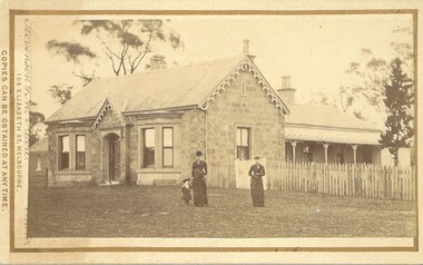
Photograph, Stone Villa house 4 Bennett Street Bacchus Marsh 1883
... Stone Villa house 4 Bennett Street Bacchus Marsh 1883...Stone Villa house 4 Bennett Street Bacchus Marsh 1883 Photograph ...The house depicted in this image was constructed in 1865 for James Young a prominent local businessman and participant in community affairs. James Young left Bacchus Marsh in 1869. In 1870 Stone Villa was purchased by local solicitor Francis Gell. In 1872 it was bought by William Collyer. For a time before 1883 it was used as a school operated by Mr Thomas Kissock and his wife. From 1883 until 1922 it was used as a parsonage by the Church of England. In 1922 it was sold to Frederick Slack as a private residence. Since Slack's ownership there have been other owners. As of April 2024 it remains as a private residence and is listed as a heritage property in the Moorabool Shire planning scheme. The identity of the two women and young girl in the foreground of the image has not been established. One of the women, and the child are possibly the wife and daughter of the Rev A.C. McCausland who was the Church of England Vicar in Bacchus Marsh from 1872 until 1885 and would have resided in this house in 1883 when this picture was produced.An early visual record of one of the most culturally and architecturally significant nineteenth century stone houses in Bacchus Marsh.Small sepia 'carte de visite' style unframed photograph on card with gold border framing photograph. Housed in the album, 'Photographs of Bacchus Marsh and District in 1883 by Stevenson and McNicoll', the Jeremeas Family Album. The photo is of a stone dwelling with an ornate gable above the inset front door which is flanked by two double windows, one of which is a bay window. The gable roof line bears ornate woodwork. A weatherboard extension with verandah has been added to the rear of the house, running north-south. A picket fence lines the block to the side of the dwelling. Two elegantly dressed women, both holding a furled umbrella, stand at the front, one holding the hand of a little girl.Printed On the front: Stevenson & McNicoll. Photo. 108 Elizabeth St. Melbourne. COPIES CAN BE OBTAINED AT ANY TIME. On the back: LIGHT & TRUTH inscribed on a banner surmounted by a representation of the rising sun. Copies of this Portrait can be had at any time by sending the Name and Post Office Money Order or Stamps for the amount of order to STEVENSON & McNICOLL LATE BENSON & STEVENSON, Photographers. 108 Elizabeth Street, MELBOURNE. Hand written on the reverse: 'Stone Villa built by James Young 1860 (sic) as his private residence, later as a school (Mr and Mrs Kissock proprietors) bought by CofE for Vicarage 1883-1922. Courtesy of Mrs J Jeremeas, Photo 1883' james young 1816-1871, houses, stone villa bacchus marsh, clergy residences, bacchus marsh vic. history, schools bacchus marsh, stevenson and mcnicoll 1883 photographs of bacchus marsh and district -
![Map, Plan of Town Allotments Bacchus Marsh [1891-1897]](/media/collectors/5e461d8021ea67224c82f2a1/items/66acc1c90c778f9f64a3daec/item-media/66acc3990c778f9f64a3e09b/item-fit-380x285.jpg?cb=6) Bacchus Marsh & District Historical Society
Bacchus Marsh & District Historical SocietyMap, Plan of Town Allotments Bacchus Marsh [1891-1897]
... This plan of town allotments in Lerderderg Street and Bennett Street also includes the location of many of the buildings, shops, businesses and houses which were present in the retail and business area of Bacchus Marsh in the 1890s. ...Streets identified on plan: Lerderderg Street - Bennett Street - Main Street - Gell Street - Young Street - Graham Street. ...Streets identified on plan: Lerderderg Street - Bennett Street - Main Street - Gell Street - Young Street - Graham Street. ...This plan of town allotments in Lerderderg Street and Bennett Street also includes the location of many of the buildings, shops, businesses and houses which were present in the retail and business area of Bacchus Marsh in the 1890s. The precise date of the plan is not known but it must be sometime between 1891 and 1897. The Post Office and the Wesleyan Church are both shown on this plan. Both of these were constructed in 1890. The plan does not show the Baptist Church in Main Street which was constructed in 1898. Hence the date is sometime between 1891 and 1897.This plan of Bacchus Marsh is one of the most detailed visual representations of the location of shops, businesses and houses in the central part of Bacchus Marsh. It provides very precise locations of most of the shops and houses in the town in the 1890s. A single page paper plan showing allotments of land fronting Lerderderg and Bennett Street. Buildings, businesses and houses along most of the streets are identified by hand written annotations. Streets identified on plan: Lerderderg Street - Bennett Street - Main Street - Gell Street - Young Street - Graham Street. Physical boundaries of the map are: North border - Lerderderg Street - South border - Main Street - West border Gell Street - East border - Young Street. The plan is pasted into a bound volume containing 76 maps or plans in total. bacchus marsh victoria maps, shops bacchus marsh -
 Federation University Historical Collection
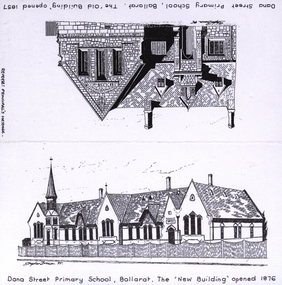
Card, Card to Margaret Bennett from Dana Street Primary School Principal, 1999
... Card to Margaret Bennett from Dana Street Primary School Principal...dana street primary school...margaret bennett...Card to Margaret Bennett from Dana Street Primary School Principal Card ...Card sent to Ms Margaret Bennett thanking her for attending their assembly and mentioning the reunion to be held on 17/02/1999.dana street primary school, margaret bennett, wendy baker, principal, ballarat teachers' college -
 Linton and District Historical Society Inc
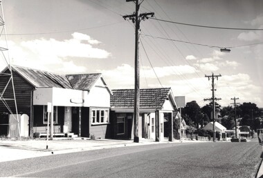
Photograph, House at 79 Sussex Street, and former Bennett Garage (79A Sussex Street)
... House at 79 Sussex Street, and former Bennett Garage (79A Sussex Street)......Bennett Bros. Garage...79 Sussex Street...Street, Linton. Photograph taken in 1982, showing a house which was owned by Joseph Shepherd from the 1880s and lived in by his niece Mary Ann Shepherd until 1921. Next to it is a brick building, the former motor garage built in the 1930s by Bennett Bros. ...Next to it is a brick building, the former motor garage built in the 1930s by Bennett Bros. House at 79 Sussex Street, and former Bennett Garage (79A Sussex Street) Photograph ...Around 1930, the Bennett Brothers' garage replaced a produce store that had operated since the 1860s. The house has had numerous owners and functions since it was owned by Joseph Shepherd in the 1880s - among other things it has been used as an opportunity shop, and as a laundromat.Black and white photograph of two buildings on the east side of Sussex Street, Linton. Photograph taken in 1982, showing a house which was owned by Joseph Shepherd from the 1880s and lived in by his niece Mary Ann Shepherd until 1921. Next to it is a brick building, the former motor garage built in the 1930s by Bennett Bros. houses, bennett bros. garage, 79 sussex street linton, joseph shepherd -
 Linton and District Historical Society Inc
Photograph, Sussex Street 1930s : Bennett Butchers, Criterion House, former Joseph Shepherd house
... Sussex Street 1930s : Bennett Butchers, Criterion House, former Joseph Shepherd house...Bennett is shown trading at the store formerly owned by Joseph Shepherd/Alf Darling. Criterion House appears to be unoccupied, suggesting photo was taken after 1932 when Murrell's Newsagency moved from this site across to the west side of Sussex Street (to shop previously occupied by Dan Cornish)....Cars and a horse in the street. Buildings are G. G. Bennett butcher's shop, Criterion House, and the house built and formerly occupied by Joseph Shepherd. ...A glimpse of the Linton Economic Store (owned by Morgan family) further along the street. Sussex Street 1930s : Bennett Butchers, Criterion House, former Joseph Shepherd house Photograph ...Photograph is dated to 1930s as G. G. Bennett is shown trading at the store formerly owned by Joseph Shepherd/Alf Darling. Criterion House appears to be unoccupied, suggesting photo was taken after 1932 when Murrell's Newsagency moved from this site across to the west side of Sussex Street (to shop previously occupied by Dan Cornish).Somewhat grainy copy of original black and white photograph which shows buildings in Sussex Street, Linton, in the 1930s. Cars and a horse in the street. Buildings are G. G. Bennett butcher's shop, Criterion House, and the house built and formerly occupied by Joseph Shepherd. A glimpse of the Linton Economic Store (owned by Morgan family) further along the street.g. g. bennett, criterion house, joseph shepherd -
 Sunshine and District Historical Society Incorporated
Administrative record - City of Sunshine - Commissioner Mr Alexander Alex George Gillon Collection 1976 - 1982 - Notice of ordinary meeting of the council 10th February 1981, City of Sunshine, 4th February 1981
... ...Bennett Street...Olympic Games The Catholic Family Welfare Bureau emergency family accommodation 10 Dodd Street Braybrook Land Transfer Part of Omega Street Discontinued proposed Land Transfer Former Right of Way off Station Road between Poole Street and Tulloch Street Proposed Land Transfer George Street Maidstone Proposed to Discontinue part of Charlotte Street South of Hall Street Kiosk Sunshine Swimming Pool Demise of Land Howard Kingham Lodge Industrial Tipping Agreements City of South Melbourne Proposed Technical School Keilor More Park Committee of Management Proposed Pavilion Larissa Reserve Cherry Crescent Pre-School / Child Care Centre Maribyrnong Senior Citizens' Club Randall Street Removal of Dwelling from 18 Bennett Street Sunshine West to 32 Dale Avenie Pascoe Vale Health Act Registrations Aycliffe Drive Infant Welfare Centre Billingham Road Bridge over Kororoit Creek Maribyrnong River Valley Flooding Planning Permit Application Radio Mast Beaver Street St. ...Albans Cherry Crescent Maribyrnong Senior Citizens' Club Randall Street Maribyrnong Bennett Street Aycliffe Drive Billingham Road Kororoit Creek Maribyrnong River Valley Maribyrnong River Beaver Street Station Place Rosamond Road Orama Street West Street Richards Street Ridley Street Albion Carrington Drive Commercial Street Main Road West Emu Road Highpoint West Ashley Street Footscray West perry Vickers Somerville Road Tottenham Parade McIntyre Road Sunshine North Main Road East Sunshine Avenue Hampstead Road Frederick Road Justin Road Tottenham Lysaght Durham Chemical Company ETA Cranwell Street Lacy Street Railway Parade Furlong Road St. ...Olympic Games The Catholic Family Welfare Bureau emergency family accommodation 10 Dodd Street Braybrook Land Transfer Part of Omega Street Discontinued proposed Land Transfer Former Right of Way off Station Road between Poole Street and Tulloch Street Proposed Land Transfer George Street Maidstone Proposed to Discontinue part of Charlotte Street South of Hall Street Kiosk Sunshine Swimming Pool Demise of Land Howard Kingham Lodge Industrial Tipping Agreements City of South Melbourne Proposed Technical School Keilor More Park Committee of Management Proposed Pavilion Larissa Reserve Cherry Crescent Pre-School / Child Care Centre Maribyrnong Senior Citizens' Club Randall Street Removal of Dwelling from 18 Bennett Street Sunshine West to 32 Dale Avenie Pascoe Vale Health Act Registrations Aycliffe Drive Infant Welfare Centre Billingham Road Bridge over Kororoit Creek Maribyrnong River Valley Flooding Planning Permit Application Radio Mast Beaver Street St. Albans Planning Permit Application Hairdressing Salon 62 Station Place Sunshine Planning Permit Application Service Premises Alterations and extensions 123 Rosamond Road Maidstone Planning Permit Application Detached House Lot 284 Orama Street Deer Park Planning Permit Application Erection of iron fence Lot 664 West Street Sunshine West Planning Permit Application Extension to existing building Lots 44 & 45 and Nos 3 & 5 Richards Street Maidstone Land Use Permit Apartment house and caretaker's residence 16 Ridley Street Albion Planning Permit Application Transport and storage depot 16 Carrington Drive Albion Planning Permit Application Hot Bread Kitchen 9 Commercial Street Maidstone Planning Permit Application Laundrette Lot 1 Main Road West St. Albans Planning Permit Application Warehouse (Cold Store) Lot 2 Emu Road Maidstone Planning Permit Application Extension to garden shop Highpoint West Rosamond Road Maribyrnong Planning Permit Application Access widening Ashley Street Footscray West Planning Permit Application Office alternations Sperry Vickers 169 Rosamond Road Maribyrnong Planning Permit Application Factory renovations Somerville Road South West corner of Tottenham Parade Brooklyn Planning Permit Application Factory Lot 12 McIntyre Road Sunshine North Planning Permit Application Retail plant nursery corner of McIntyre Road and Main Road East and Sunshine Avenue Proposed Telecom Western Radio Telephone Terminal Commonwealth Land Hampstead Road Maidstone Plan of Transfer and Consolidation A. T. Stead Frederick Road and Justin Road Plan of Transfer Lysaght Durham Chemical Company Somerville Road Tottenham Plan of Subdivision ETA Cranwell Street and Lacy Street Braybrook Consolidation of Title Railway Parade Sunshine Traffic Signals Furlong Road and St. Albans Road St. Albans Street Lighting Agreement with City of Footscray for Princess Highway between Tottenham Parade & Holmwood Road and Francis Street & McDonald Road M.M.B.W. Land abutting Collenso Street School Crossing Furlong Road between Austin Street and Browne Avenue St. Albans Trees in Duke Street Sunshine North Closure of Omar Street to through traffic Pennell Reserve roof replacement Building over Easement 6 Busch Street Sunshine North Location of Building Lot 335 Maxweld Street Ardeer Verandah installation Lot 479 Kardina Drive St. Albans Location of Building 26 Harrison Street Deer Park Permission to Erect Building Lot 138 Keynes Court Deer Park Location of Building 9 Dinnell Street Sunshine West Location of Building 9 Walker Place Braybrook Building over Easement 9 Larool Crescent Sunshine West Location of Building Lot 990 Mulhall Drive St. Albans Fire Separation within a Building 22 St. Albans Road Sunshine Fence Lot 20 Riverview Court Maribyrnong Above ground water tank Lots 2 & 5 Frederick Street Building over Council Property Ravenhall Street Braybrookolympic games, catholic family welfare bureau, dodd street, braybrook, omega street, sunshine, station road, poole street, tulloch street, deer park, george street, maidstone, charlotte street, hall street, sunshine west, sunshine swimming pool, kennedy street, howard kingham lodge, darnley street, more park committee of management, more park, esmond street, ardeer, st. albans, cherry crescent, maribyrnong senior citizens' club, randall street, maribyrnong, bennett street, aycliffe drive, billingham road, kororoit creek, maribyrnong river valley, maribyrnong river, beaver street, station place, rosamond road, orama street, west street, richards street, ridley street, albion, carrington drive, commercial street, main road west, emu road, highpoint west, ashley street, footscray west, perry vickers, somerville road, tottenham parade, mcintyre road, sunshine north, main road east, sunshine avenue, hampstead road, frederick road, justin road, tottenham, lysaght durham chemical company, eta, cranwell street, lacy street, railway parade, furlong road, st. albans road, princess highway, collenso street, austin street, browne avenue, duke street, omar street, pennell reserve, burke street, busch street, maxweld street, kardina drive, harrison street, keynes court, dinnell street, walker place, larool crescent, mulhall drive, riverview court, ravenhall street, larissa reserve -
 Kew Historical Society Inc
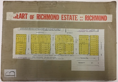
Plan - Subdivision Plan, J R Mathers & McMillan, Heart of Richmond Estate : Richmond, 1928
... Area includes Johnson Street, Victoria Street, Kennedy Street, Cole Street, Hollick Street, Bennett Street...Area includes Johnson Street, Victoria Street, Kennedy Street, Cole Street, Hollick Street, Bennett Street Heart of Richmond Estate : Richmond Plan Subdivision Plan J R Mathers & McMillan ..."In 1928 the land on the east side of Johnson Street was subdivided in 60 lots for the ‘Heart of Richmond Estate’. The houses in the subdivision, along the east side of Johnson Street, and in the newly created Hollick, Cole and Kennedy streets were constructed from 1928 to 1937." (Source: City of Yarra Heritage Gaps Review One 2013)Portion of subdivision plan pasted on to cardboard. Area includes Johnson Street, Victoria Street, Kennedy Street, Cole Street, Hollick Street, Bennett StreetTitle Certificate Vol.2381, Folio 476130 Phillips, Fox & Masel, 440 Little Collins Street, Melbourne (Local estate agent: Jas. R. Mathers & McMIllan, 136 Cotham Road, Kew)subdivision plans - richmond (vic.), heart of richmond estate -
 Federation University Historical Collection
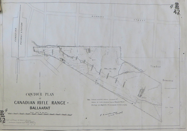
Plan, Contour Plan of the Canadian Rifle Range Ballaarat, 1906, 12/10/1906
... ...bennett street, canadian...canadian rifle range canadian railway station g.f. wilkinson ranger's quarters magazine bennett street, canadian Copy of a contour plan of the Canadian Rifle Range, on the outskirts of Ballarat. ...Copy of a contour plan of the Canadian Rifle Range, on the outskirts of Ballarat. The Rifle Range was in close proximity to the former Canadian Railway Station.canadian rifle range, canadian railway station, g.f. wilkinson, ranger's quarters, magazine, bennett street, canadian -
 Bendigo Historical Society Inc.
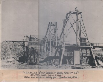
Photograph - OLD CARLISLE, NORTH GARDEN AND PASSBY MINES, c.1870
... Black and white photograph of Old Carlisle, North Garden and Passby Mines in the 1870's. Bennett Street, Long gully. Note the lack of safety gear. ...History House 11 Mackenzie Street Bendigo goldfields COTTAGE Miners Black and white photograph of Old Carlisle, North Garden and Passby Mines in the 1870's. Bennett Street, Long gully. Note the lack of safety gear. ...Black and white photograph of Old Carlisle, North Garden and Passby Mines in the 1870's. Bennett Street, Long gully. Note the lack of safety gear. Typical of the period.cottage, miners -
 Bendigo Historical Society Inc.
Newspaper - LONG GULLY HISTORY GROUP COLLECTION: GRANITE HORSE TROUGH
... Copy of a newspaper article titled Still in Use mentions a granite horse trough at the corner of Bennett Street and Havilah Road. Accompanying photo shows two Eaglehawk High School students, Ian Coyle and Geoff Lindrea inspecting the trough....History House 11 Mackenzie Street Bendigo goldfields BENDIGO History long gully history group The Long Gully History Group - Granite Horse Trough Eaglehawk High School Ian Coyle Geoff Lindrea Copy of a newspaper article titled Still in Use mentions a granite horse trough at the corner of Bennett Street and Havilah Road. Accompanying photo shows two Eaglehawk High School students, Ian Coyle and Geoff Lindrea inspecting the trough. ...Copy of a newspaper article titled Still in Use mentions a granite horse trough at the corner of Bennett Street and Havilah Road. Accompanying photo shows two Eaglehawk High School students, Ian Coyle and Geoff Lindrea inspecting the trough.bendigo, history, long gully history group, the long gully history group - granite horse trough, eaglehawk high school, ian coyle, geoff lindrea -
 Bendigo Historical Society Inc.
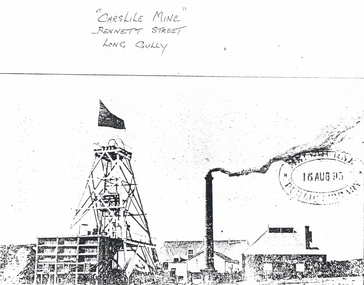
Photograph - LONG GULLY HISTORY GROUP COLLECTION: CARSLILE MINE
... Written at the top is - Carslile Mine Bennett Street Long Gully....Written at the top is - Carslile Mine Bennett Street Long Gully. Photograph LONG GULLY HISTORY GROUP COLLECTION: CARSLILE MINE ...Copy of a photo of the Carslile Mine. Photo shows chimney, poppet legs with flag flying and buildings. An oval stamp on the photo has an unreadable name and a date 16 Aug 95. Written at the top is - Carslile Mine Bennett Street Long Gully.bendigo, history, long gully history group, the long gully history group - carslile mine -
 Bendigo Historical Society Inc.
Slide - R.C.CHURCHES OF BENDIGO, July 1961
... Pius Church, Cnr Bennett & Buckley Streets,Long Gully....History House 11 Mackenzie Street Bendigo goldfields SLIDE Bendigo r.c.churches of bendigo. R.C.Churches of Bendigo. Slide. R.C.Churches of Bendigo. St. Pius Church, Cnr Bennett ...Slide. R.C.Churches of Bendigo. St. Pius Church, Cnr Bennett & Buckley Streets,Long Gully.slide, bendigo, r.c.churches of bendigo., r.c.churches of bendigo. -
 Bendigo Historical Society Inc.
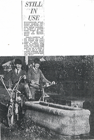
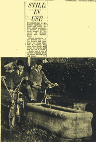
Document - LONG GULLY HISTORY GROUP COLLECTION: STILL IN USE
... Photo shows two Eaglehawk High School students, Ian Coyle and Geoff Lindrea inspecting a granite horse trough at the corner of Bennett Street and Havilah Road. The boys are sitting on their bikes, one with his foot resting on the end of the trough....Photo shows two Eaglehawk High School students, Ian Coyle and Geoff Lindrea inspecting a granite horse trough at the corner of Bennett Street and Havilah Road. The boys are sitting on their bikes, one with his foot resting on the end of the trough. ...Photocopy of a newspaper article titled Still in Use. Photo shows two Eaglehawk High School students, Ian Coyle and Geoff Lindrea inspecting a granite horse trough at the corner of Bennett Street and Havilah Road. The boys are sitting on their bikes, one with his foot resting on the end of the trough.bendigo, history, long gully history group, the long gully history group - still in use, eaglehawk high school, ian coyle, geoff lindrea, granite horse trough -
 Bendigo Historical Society Inc.
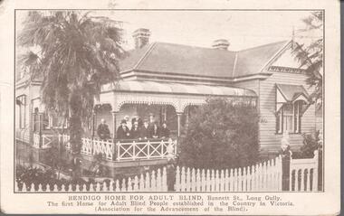
Postcard - WARNE COLLECTION: BENDIGO HOME FOR ADULT BLIND
... The postcard is labelled: Bendigo home for adult blind, Bennett Street, Long Gully. The first home for adult blind people established in the country in Victoria. ...The postcard is labelled: Bendigo home for adult blind, Bennett Street, Long Gully. The first home for adult blind people established in the country in Victoria. ...Black and white postcard showing a weatherboard house with nine people on the porch. The postcard is labelled: Bendigo home for adult blind, Bennett Street, Long Gully. The first home for adult blind people established in the country in Victoria. (Association for the advancement of the blind). The back few lines to a Maude from H Coad (?)bendigo, buildings, bendigo home for adult blind -
 Stawell Historical Society Inc
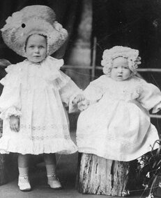
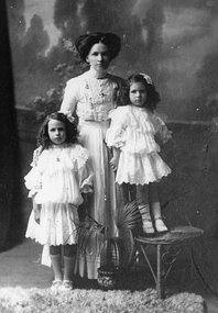
Photograph, Miss Margaret May Frawley and Miss Wilfred Lillias Frawley 1908 -- Studio Portait
... Margaret May married Jack Hall and lived 18 Bennett Street....Margaret May married Jack Hall and lived 18 Bennett Street. Stawell Miss Margaret May Frawley and Miss Wilfred Lillias Frawley 1908 -- Studio Portait Photograph ...Portrait of a two young children. (Example of Costume) 1908. Margaret May Frawley and Wilfred Lillias Frawley. Margaret May married Jack Hall and lived 18 Bennett Street.stawell -
 Bendigo Historical Society Inc.
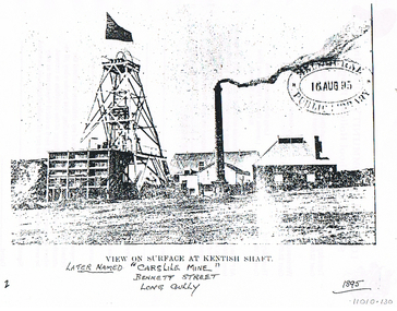
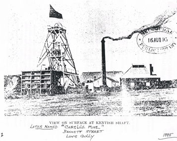
Photograph - LONG GULLY HISTORY GROUP COLLECTION: VIEW ON SURFACE AT KENTISH SHAFT
... Written under the title: Later named Carslile Mine. Bennett Street Long Gully. 1895. Also an oval stamp Unreadable name Public Library 16 Aug 95....Written under the title: Later named Carslile Mine. Bennett Street Long Gully. 1895. Also an oval stamp Unreadable name Public Library 16 Aug 95. ...View on surface at Kentish Shaft printed under the photo. Photo shows the poppet legs with flag flying, smoke coming from the chimney. Various buildings behind the chimney. Written under the title: Later named Carslile Mine. Bennett Street Long Gully. 1895. Also an oval stamp Unreadable name Public Library 16 Aug 95.bendigo, history, long gully history group, the long gully history group - kentish shaft, carslile mine -
 Darebin Parklands Association
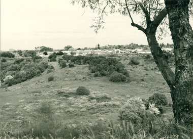
Mulberry Spur with views, 1974, 1974
... View of houses in Bennett Street, Alphington and Northcote Hill in the distance. ...View of houses in Bennett Street, Alphington and Northcote Hill in the distance. ...The widespread artichoke weed and other environmental weeds had to be cleared before planting could commence.B&W photograph. Land proposed as Parklands. View of houses in Bennett Street, Alphington and Northcote Hill in the distance. The artichoke weed can be seen across the foreground. This item and all other Darebin Parklands Association archival material is now held by State Library Victoria (Accession No: YMS 13746). Please contact State Library Victoria if access is required. -
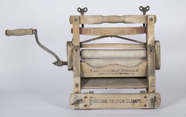 Bacchus Marsh & District Historical Society
Domestic object, Clothes Ace Wringer
... Clothes wringer used in the James Young owned house known as the Stone Villa, Bennett Street, Bacchus Marsh. Wringers, also called mangles were used to squeeze water from washed clothes....This object which was recovered from his house in Bennett Street is indicative of laundry equipment that many moderately affluent households would have owned in the 1860s. ...Clothes wringer used in the James Young owned house known as the Stone Villa, Bennett Street, Bacchus Marsh. Wringers, also called mangles were used to squeeze water from washed clothes.James Young was a prominent early resident of Bacchus Marsh from the 1850s until the 1870s. This object which was recovered from his house in Bennett Street is indicative of laundry equipment that many moderately affluent households would have owned in the 1860s.Clothes wringer or clothes mangle. Wood and metal components. Clothes Ace Wringer; Warranted 3 years for family use; Superior to Iron Clampsjames young, laundry equipment -
 Bendigo Historical Society Inc.
Photograph - LONG GULLY HISTORY GROUP COLLECTION: VIEW ON SURFACE AT KENTISH SHAFT
... Written underneath is Later Named 'Carslile Mine' Bennett Street Long Gully 1895. Unknown Public Library stamp on the right dated 16 Aug 95....Written underneath is Later Named 'Carslile Mine' Bennett Street Long Gully 1895. Unknown Public Library stamp on the right dated 16 Aug 95. ...Copy of a photo of the surface at the Kentish Shaft. In the photo is the poppet legs with a flag flying, a large storage shelves, mine buildings, smoking chimney and some horse drawn vehicles. Printed under the photo is View on Surface at Kentish Shaft. Written underneath is Later Named 'Carslile Mine' Bennett Street Long Gully 1895. Unknown Public Library stamp on the right dated 16 Aug 95.bendigo, history, long gully history group, the long gully history group - view on surface at kentish shaft, carslile mine -
 Stawell Historical Society Inc
Photograph, Mrs Henrietta May Frawley (nee Stephens) of Clunes with her two daughters, Margaret Mary Frawley (known as May) & Willfra Lillias Frawley 1911 -- Studio Portrait
... Margaret Mary married John (Jack) Hall and lived 18 Bennett Street....Margaret Mary married John (Jack) Hall and lived 18 Bennett Street. Stawell Studio Portrait of woman Standing with two young girls. ...Portrait of a Female and two children. (Example of Costume) 1911. Henrietta May Frawley (nee Stephens) of Clunes and her two daughters. Margaret Mary Frawley (May) and Wilfred Lillias Frawley. Margaret Mary married John (Jack) Hall and lived 18 Bennett Street.Studio Portrait of woman Standing with two young girls.stawell -
 Vision Australia
Photograph - Image, Andrew Jacob, Bendigo Home for the Blind, c1927
... Housing 18 people, it was acquired by the Association for the Advancement of the Blind, and located in Bennett Street. In 1934 the committee looked at extensions to cope with demand, however the cost proved to be too great and instead a property in Inglewood Road was obtained in 1935. ...Housing 18 people, it was acquired by the Association for the Advancement of the Blind, and located in Bennett Street. In 1934 the committee looked at extensions to cope with demand, however the cost proved to be too great and instead a property in Inglewood Road was obtained in 1935. ...On August 10, 1927 the first Bendigo Home for the Blind was opened in Long Gully. Housing 18 people, it was acquired by the Association for the Advancement of the Blind, and located in Bennett Street. In 1934 the committee looked at extensions to cope with demand, however the cost proved to be too great and instead a property in Inglewood Road was obtained in 1935. Written on the back of the image: Hennessy A1695.1 scanned image of black and white photographassociation for the advancement of the blind, mirridong home (bendigo) -
 Ringwood and District Historical Society
Document - Map, Plan of Subdivision - Part of Crown Allotments 14A & 14C, Parish of Ringwood, County of Mornington, Vol 5378 Fol 511 - 1927
... Map includes Canterbury Road, Heathmont Road, Dickasons Road, Bennett Avenue, Orchid Street and Allens Road, Heathmont, Vic....Ringwood and District Historical Society 125A Warrandyte Road Ringwood North melbourne Map includes Canterbury Road, Heathmont Road, Dickasons Road, Bennett Avenue, Orchid Street and Allens Road, Heathmont, Vic. ...Department of Lands and Survey photocopy dated 17/1/1951, page number 12308.Map includes Canterbury Road, Heathmont Road, Dickasons Road, Bennett Avenue, Orchid Street and Allens Road, Heathmont, Vic. -
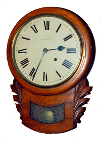 Federation University Historical Collection
Decorative object - Horology, Wall Clock by William Bennett of Ballarat, c1880
... The clock would have been sold by William Bennett of Bridge Street, Ballarat, under his name....Barker Library (top floor) Mount Helen goldfields The clock would have been sold by William Bennett of Bridge Street, Ballarat, under his name. william bennett clocks horology ansonia watchmaker Timber drop case wall clock. ...The clock would have been sold by William Bennett of Bridge Street, Ballarat, under his name.Timber drop case wall clock. The movement it by Ansonia Clock Company of New York United States of America, and the case is most probably of European origin.william bennett, clocks, horology, ansonia, watchmaker -
 Whitehorse Historical Society Inc.
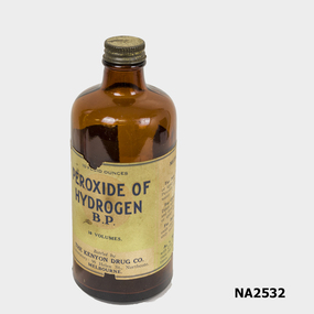
Bottle
... Used by Philip Bennett of 122 Thames Street Box Hill....Whitehorse Historical Society Inc. 2-10 Deep Creek Road Mitcham melbourne Used by Philip Bennett of 122 Thames Street Box Hill. MEDICINE Pharmacy GLASS TECHNOLOGY Bottles Peroxide of Hydrogen B.P. ...Used by Philip Bennett of 122 Thames Street Box Hill.Brown glass bottle with screw cap containing peroxide of hydrogen. Label.Peroxide of Hydrogen B.P.|Bottled by the Kenyon Drug Co. 99 Helen Street, Northcote, Melbourne.medicine, pharmacy, glass technology, bottles -
 Whitehorse Historical Society Inc.
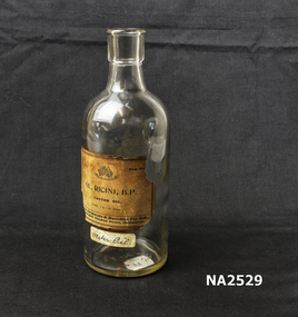
Container - Bottle
... Used bt Philip Bennett of`122 Thames Street, Box Hill , 1926 to 1997....Whitehorse Historical Society Inc. 2-10 Deep Creek Road Mitcham melbourne Used bt Philip Bennett of`122 Thames Street, Box Hill , 1926 to 1997. medicine pharmacy glass technology bottles Ol. ...Used bt Philip Bennett of`122 Thames Street, Box Hill , 1926 to 1997.Clear glass bottle with cork. Contains Castor Oil. Label.Ol. Ricini, B.P. Castor Oil.medicine, pharmacy, glass technology, bottles -
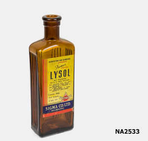 Whitehorse Historical Society Inc.
Container - Bottle
... Used by Philip Bennett of 122 Thames Street Box hill,m 1926-1997....Whitehorse Historical Society Inc. 2-10 Deep Creek Road Mitcham melbourne Used by Philip Bennett of 122 Thames Street Box hill,m 1926-1997. MEDICINE Pharmacy GLASS TECHNOLOGY Bottles Lysol Disinfectant + germicide Brown glass bottle, with cork, containing Lysol. ...Used by Philip Bennett of 122 Thames Street Box hill,m 1926-1997.Brown glass bottle, with cork, containing Lysol. Label.Lysol Disinfectant + germicidemedicine, pharmacy, glass technology, bottles -
 Bendigo Historical Society Inc.
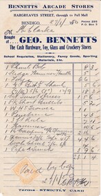
Document - DONALD CLARKE COLLECTION: GEO. BENNETTS INVOICE
... Bennetts Arcade Stores, Hargreaves Street, Bendigo. Invoice for £23.1.4, issued to Mr. ...Bennetts Arcade Stores, Hargreaves Street, Bendigo. Invoice for £23.1.4, issued to Mr. ...Invoice dated 27.1.1950 for hardware items purchased from Geo. Bennetts Arcade Stores, Hargreaves Street, Bendigo. Invoice for £23.1.4, issued to Mr. Clarke.business, retail, geo. bennetts arcade store