Showing 59 items matching "black swamp"
-
 Friends of Ballarat Botanical Gardens History Group
Work on paper - The Black Swamp and Lake Wendouree's Water Supply. The Ballarat Courier,18/3/2006, The Lake in the Nineteenth Century and the Problems with Water, 18/3/2006
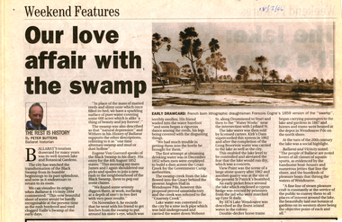
... The Black Swamp and Lake Wendouree's Water Supply. ......Black Swamp...Work on paper The Black Swamp and Lake Wendouree's Water Supply. ...There is a brief history of the Lake including discussion of the problems with the water supply over the years and then in 2006 during the millenium drought.The two articles give some perspective on longstanding concerns about the water supply for Ballarat and particularly Lake Wendouree.1 page, both sides of newsprint. p.1 is entitled "Our Love Affair with the Swamp". There is a coloured picture of the Swamp, top lefthand side of the page. Overleaf, "The Lake: it's a Dry Argument". There is a coloured picture of the Lake, top lefthand side of page and the bottom lines have been cut through.p.1, top left, written in blue biro "Courier, 18/3,2006.john garner, doctor john garner, ballarat botanic gardens, friends of ballarat botanical gardens, lake wendouree, francois cogne, black swamp, yuille's swamp., ballarat water supply, john garner collection, gardens, ballarat -
 Friends of Ballarat Botanical Gardens History Group
Work on paper - William Cross Yuille (28/3/1819 - 19/7/1894), Life, Work and Legacy, 20/11/2011
... ...Black Swamp...The Black Swamp in western Ballarat frequently ca to be called Yuille's Swamp and in time, Lake Wendouree....Friends of Ballarat Botanical Gardens History Group George Longley Building Gillies Street North entrance Ballarat West 3350 The Black Swamp in western Ballarat frequently ca to be called Yuille's Swamp and in time, Lake Wendouree. ...The Black Swamp in western Ballarat frequently ca to be called Yuille's Swamp and in time, Lake Wendouree.William Yuille had a station, south of the Swamp, which became part of the gold rush settlement of Ballarat in 1838.2 pages of printNonejohn garner, doctor john garner, lake wendouree, yuille's swamp, black swamp, ballarat botanic gardens, friends of ballarat botanical gardens, william cross yuille, grazier, explorer, pioneer, scot, horse trainer, victoria racing club, squatter, gardens, ballarat, john garner collection -
 Federation University Historical Collection
Map, Ballarat Goldfield, c1898
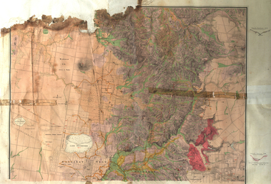
... ...Black Swamp Lead...The map indicates the position of Lake Wendouree, Township of Warrenheip, Ballarat East, Industrial School Reserve, Winters Swamp, Police Paddock, Wyndholm Premptive Right (Salton and Waldie), Black Hill, Vale Park Reserve, Pennyweight Hill, Little Bendigo, Black Swamp Lead, monte Christo Reef, Chinaman's Gully, Miners Rest, Pincotts Dam, Northumberland Gully. ...The map indicates the position of Lake Wendouree, Township of Warrenheip, Ballarat East, Industrial School Reserve, Winters Swamp, Police Paddock, Wyndholm Premptive Right (Salton and Waldie), Black Hill, Vale Park Reserve, Pennyweight Hill, Little Bendigo, Black Swamp Lead, monte Christo Reef, Chinaman's Gully, Miners Rest, Pincotts Dam, Northumberland Gully. ...This map shows geological features, suggests the last basalt flow, and includes alotments and names of Mining Companies. Although this map has no date on it the Ballarat Industrial School is used for dating purposed. The Ballarat Industrial School ran from 1869-1879, but the term Ballarat Industrial School Reserve was still in use in 1898 and possibly beyond.Geological Map of Ballarat with 3 holes in the left hand side. The map indicates the position of Lake Wendouree, Township of Warrenheip, Ballarat East, Industrial School Reserve, Winters Swamp, Police Paddock, Wyndholm Premptive Right (Salton and Waldie), Black Hill, Vale Park Reserve, Pennyweight Hill, Little Bendigo, Black Swamp Lead, monte Christo Reef, Chinaman's Gully, Miners Rest, Pincotts Dam, Northumberland Gully. It also show the following goldmining companies: City of Ballarat, Kohinor, Hand and Band, Great North West, Northern Junction, Kneeshaw, Rossers Freehold, Silurial.ballarat, warrenheip, lake wendouree, ballarat east, winters swamp, winter swamp, wyndholm premptive right, cemetery, vale park reserve, little bendigo, kneeshaw co., industrial school reserve, kirks dam, pincotts dam, black hill, wombat hill, dead horse gully, miners rest, mt rowan, salton and waldie, rose hill co, great north west no 1, rose's freehold co, hand and band co, police reserve, police paddock, mount rowan, ballarat industrial school reserve, market reserve, winter's swamp, kneeshar co, monte cristo line of reef, chinaman's gully or black snake, milkmaid's gully, ballarat gold field, bakery hil lead, old gravel pits lead, golden point lead, eureka lead, miner's rest, yarrowee creek, leigh creek, black swamp lead, yorkshire reef, nil desperandum reef, cockatoo lead, hit or miss gully, herbert werner frederick de nully, pennyweight hill, esmond's lead, ash's lead, nightingale lead, john bull gully, gladstone reef, whitehorse reef, petticoat creek, pincott's dam, frenchman's gully, tim's crushing plant, jenkin's gully, california gully, drake's creek, sulton and waldie, ballarat undustrial school, ballarat & mariborough railway -
Friends of Ballarat Botanical Gardens History Group
Work on paper - Two Talks by Peter Butters, Yuille's Swamp and Our Botanical Gardens
... ...Black Swamp...John Garner Doctor John Garner Ballarat Botanical Gardens Friends of Ballarat Botanical Gardens Yuille's Swamp Lake Wendouree Black Swamp Tourism Eugene von Guerard Gnarr Creek Ballarat Water Supply Gong Reservoir View Point Trams Fry's Mill .Mining English birds Acclimatization Society Fish Carp cormorants Reeds in Lake Wendouree acquatic sports Steam Boats George Longley Marble Statues Trees Fernery John Garner Collection Gardens Ballarat With the 1st article "Roy and then Peter Butters Talk, Guiding Group, 24/9/97" is written in blue biro, top righthand corner. ...Both articles give valuable brief histories of Lake Wendouree and Ballarat Botanical Gardens.These 2 articles explain how Lake Wendouree and the Ballarat Botanical Gardens came to be highly regarded for leisure time activities, for the study of flora and fauna and the parks and gardens.The 1st article, Yuille's Swamp is 31/2 pages of print with Peter Butters name added on p.4. The 2nd article, Our Botanical Gardens, is also 31/2 pages of print with Peter Butters name added on p.4.With the 1st article "Roy and then Peter Butters Talk, Guiding Group, 24/9/97" is written in blue biro, top righthand corner. Nothing is written in longhand on the 2nd article.john garner, doctor john garner, ballarat botanical gardens, friends of ballarat botanical gardens, yuille's swamp, lake wendouree, black swamp, tourism, eugene von guerard, gnarr creek, ballarat water supply, gong reservoir, view point, trams, fry's mill, .mining, english birds, acclimatization society, fish, carp, cormorants, reeds in lake wendouree, acquatic sports, steam boats, george longley, marble statues, trees, fernery, john garner collection, gardens, ballarat -
 Warrnambool and District Historical Society Inc.
Book, The Great Swamp, 1980s
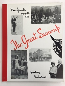
... The book also has many black and white photographs. The book is bound with red tape. The Great Swamp Book ...This book has been written by Vanda Savill and is about the settlers in the Wallacedale area in Western Victoria. Wallacedale is 28 kilometres south west of Hamilton and was created by the draining of the Condah Swamp. Vanda Savill (1913-2005) and her husband ran a dairy farm and the Bower Birds Nest Museum and History Centre at Heywood. Vanda Savill was passionate about keeping alive the personal histories of local people and for 20 years she wrote and published many books about the areas in which she lived. This book is of interest because it tells the stories of settlers in the Wallacedale area of Western Victoria. It also has appeal because of the warm, conversational style of the author.This is a soft cover book of 216 pages. The cover has a white background with a black and white image of a hand holding a pen and, on the front cover, five black and white photographs and, on the back cover, nine black and white photographs. The title of the book is in red cursive writing. The information in the book is printed from the original handwriting of the author (Vanda Savill). The book also has many black and white photographs. The book is bound with red tape.wallacedale, history of western victoria, vanda savill, warrnambool -
 Warrnambool and District Historical Society Inc.
Map - Fire Maps, Region 5 Fire Control Map, 1963
... swamps and creeks, rivers, railways, mountains and towns. These maps were produced in 1963 so are today of historical interest and they would be useful research tools. Fire Maps Warrnambool History Two fire maps of south west Victoria .1 This is a rectangular piece of linen folded several times to form a packet with the front part covered with a brown card. The cover has a blue and white label. The map has a white base with red and green markings and red and black ...Two fire maps of south west Victoria.1 This is a rectangular piece of linen folded several times to form a packet with the front part covered with a brown card. The cover has a blue and white label. The map has a white base with red and green markings and red and black printing .2 As .1 abovenon-fictionTwo fire maps of south west Victoriafire maps, warrnambool history -
Glen Eira Historical Society
Article - Vegetation
... Contains three black-and-white photographs of portraying three species of said vegetation – the swamp gum, the Kangaroo Apple and Poa grass. 3/An article from the Southern Cross, dated 13/05/1992, pertaining to Caulfield’s indigenous vegetation, and the efforts of groups and individuals such as the Caulfield Environment Group (CEG) to preserve it. ...Contains three black-and-white photographs of portraying three species of said vegetation – the swamp gum, the Kangaroo Apple and Poa grass. 3/An article from the Southern Cross, dated 13/05/1992, pertaining to Caulfield’s indigenous vegetation, and the efforts of groups and individuals such as the Caulfield Environment Group (CEG) to preserve it. ...Four items pertaining to vegetation within Caulfield: 1/2 copies of a booklet produced by the Caulfield City Council (undated) offering residents advice on the planting and care of trees within the district. Contains seven black-and-white photographs portraying various spots of vegetation within the district, plus nine black-and-white cartoons portraying the steps involved in correctly planting a tree. 2/An article from the Caulfield Contact, dated 04/1992, pertaining to Caulfield’s indigenous vegetation. Contains three black-and-white photographs of portraying three species of said vegetation – the swamp gum, the Kangaroo Apple and Poa grass. 3/An article from the Southern Cross, dated 13/05/1992, pertaining to Caulfield’s indigenous vegetation, and the efforts of groups and individuals such as the Caulfield Environment Group (CEG) to preserve it. Contains a black-and-white photograph of CEG member Paul Cain with a Red River Gum and large tussock grass, part of a re-vegetation program in a Murrumbeena linear park. 4/ A clipping from the Southern Cross, dated 20/05/1992, pertaining to the presence of Murray River red gum at Elsternwick primary school. Contains a black-and-white photograph of two pupils of the school, Craig and Emelia (surnames unmentioned), planting saplings.caulfield, plants, trees, caulfield city council, gardening, horticulture, landscape planning, caulfield contact, outer circle parklands, caulfield environment group, cain paul, smith colin, joint effort community house, outer circle railway, conservation of natural resources, murrumbeena, parks, minister for conservation, pullen barry, glenhuntly neighbourhood house, primary schools, elsternwick primary school, murphy street, mcinerney peter, elster canal -
Glen Eira Historical Society
Document - KOOYONG ROAD, 75, CAULFIELD NORTH
... black and white illustration (22x31mm) of the City of Caulfield banner. Blair Maxwell (Mayor) Hateley P.G. (Major) Finning D.J. (Captain) Lowe G. (Captain) Barker L.A. (Lieutenant) Blair Mrs. Aylen D.R. Aylan D.R. Mrs. Goltz M.H. Compton E.J. (Brigadier) Goltz M.H. (Chief Superintendant) Caulfield John Wynne Agar Murphy (Mayor) Hate P. Ison (Captain) Fisher Andrew Morris T.W. (Mayor) Caulfield Kooyong Road Caulfield Park North Caulfield City of Caulfield City Hall Balaclava Road Hawthorn Road Glen Eira Road Hartley Avenue Caulfield Racecourse Caulfield Town Hall Alma Road Orrong Road Garden Vale Caulfield Railway Station Paddy’s Swamp ...Three copies of a pamphlet for the ceremony of the Third Ordnance Services Unit ‘Exercising the Right of the Freedom of Entry to the City of Caulfield’, held on 13/07/1986. The pamphlet includes a brief history of the Unit’s association with the City of Caulfield, a list of individuals holding posts within the unit, text of the scroll conferring the Freedom of Entry on the Unit, a program of the ceremony, a brief history of the Royal Australian Army Ordnance Corps, including the Unit’s use of 75 Kooyong Road as their premises, a brief history of the city of Caulfield and an explanation of the tradition of conferring Freedom of Entry to a city. The pamphlet includes also: 1/A black and white photograph (61x66mm) of the Mayor of Caulfield, Maxwell Blair, undated and unattributed. 2/A black and white photograph (70x51mm) of Major P.G. Hateley, Commanding Officer of the Third Ordnance Services Unit, undated and unattributed. 3/A black and white photograph (91x90mm) of the Sovereign’s Banner, undated and unattributed. 4/A black and white copy (137-87) of the scroll conferring Freedom of Entry into the City of Caulfield which was seated August 4 1978. 5/A color illustration (30x32mm) of the City of Caulfield Coat of Arms. 6/A colour illustration (40x32mm) of the Third Ordnance Services Unit, Royal Australian Army Ordnance Corps Coat of Arms. 7/A black and white illustration (21x24mm) of the City of Caulfield Coat of Arms. 8/A black and white illustration (19x19mm) of the City of Caulfield badge. 9/A black and white illustration (22x31mm) of the City of Caulfield banner.blair maxwell (mayor), hateley p.g. (major), finning d.j. (captain), lowe g. (captain), barker l.a. (lieutenant), blair mrs., aylen d.r., aylan d.r. mrs., goltz m.h., compton e.j. (brigadier), goltz m.h. (chief superintendant), caulfield john, wynne agar, murphy (mayor), hate p., ison (captain), fisher andrew, morris t.w. (mayor), caulfield, kooyong road, caulfield park, north caulfield, city of caulfield, city hall, balaclava road, hawthorn road, glen eira road, hartley avenue, caulfield racecourse, caulfield town hall, alma road, orrong road, garden vale, caulfield railway station, paddy’s swamp, great dandenong road, glen ferrie road, dandenong road, east caulfield reserve, caulfield military hospital, ‘glen eira’, town hall, ‘war office’, red chequer cab company, caulfield council, third ordnance services unit royal australian army ordnance corps, australian army, army headquarters printing press, searchlight company, amenities store, armoured replacement unit, first base printing company r.a.a.o.c., caulfield district road board, shire of caulfield, caulfield recruiting committee for volunteers, city repatriation committee, red cross emergency service, women’s national service, mayor’s patriotic fund, promotions committee for war savings certificates, war savings group scheme, ‘the gazette’, air raid precautions committee, armed forces, world war 1939-1945, local government, parades and processions, military reserves, world war 1914-1918, councillors, events and activities, historic events, official events -
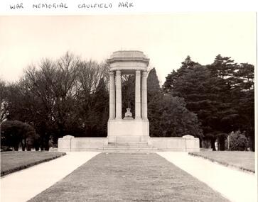 Glen Eira Historical Society
Article - Memorials in Glen Eira
... black-and-white photographs, and a copy of the original drawing of the memorial which won its design contest in 1930. Monuments and Memorials War Memorials Plaques World War 1914-1918 Caulfield Park Friends Of Caulfield Park Ritchie Mr World War 1939-1945 Koornang Park City of Caulfield Glen Eira Glen Eira Council McKinnon War Memorial Hopetoun Gardens Hyams Jamie McKinnon Lobo Oscar Esakoff Margaret Hyams Jamie Delahunty Ms Caulfield RSL Kiernan Noel Bishop Eleanor Caulfield Park War Memorial Foot Henry B. Parks and reserves Paddy's swamp ...This file contains 11 items relating to War Memorials in Glen Eira: 1/Black and white photograph, undated, source unknown, of Caulfield Park War Memorial 2/Copy of photograph of Caulfield Park War Memorial, undated, source unknown 3/Colour photograph of Caulfield Park War Memorial, dated June 1982, source unknown, and slide of same 4/Print of webpage of Friends of Caulfield Park, dated 02/08/2013 with colour image of and information about the war memorial there 5/Two black and white photographs, undated and source unknown, of war memorial at Koornang Park 6/Four colour photographs and one black and white copy of photograph of war memorial and its inscription at Koornang Park. Date and source unknown 7/Article dated 30/04/2013 from GLENEIRA LEADER about funding for plaque for Lone Pine at Caulfield Park 8/Article dated 23/04/2013 from THE AGE about state funding for repair of war memorials including one at McKinnon 9/Article dated June 2013 from GLEN EIRA NEWS about state funding for repair of five WWI memorials in Glen Eira. Includes two photographs. 10/Article from GLEN EIRA NEWS dated April 2012 about restoration of Caulfield Park War Memorial. Includes colour photography 11/A booklet titled 'The Burra Charter and its Application: Essay 3: War Memorial, Caulfield Park', written in October 2000 by Eleanor Bishop. The booklet contains a conservation analysis, statement of cultural significance, statement of conservation policy, and conservation management plan for the Caulfield Park War Memorial. This includes a brief history and description of the Caulfield Park War Memorial, and 7 colour photographs of the memorial dated September 2000, 2 undated black-and-white photographs, and a copy of the original drawing of the memorial which won its design contest in 1930.monuments and memorials, war memorials, plaques, world war 1914-1918, caulfield park, friends of caulfield park, ritchie mr, world war 1939-1945, koornang park, city of caulfield, glen eira, glen eira council, mckinnon war memorial, hopetoun gardens, hyams jamie, mckinnon, lobo oscar, esakoff margaret, hyams jamie, delahunty ms, caulfield rsl, kiernan noel, bishop eleanor, caulfield park war memorial, foot henry b., parks and reserves, paddy's swamp, caulfield, royal victorian institute of architects, caulfield municipal council, architectural competitions, schefferle n. mr, architectural features, conservation management plan -
 Bendigo Historical Society Inc.
Photograph - HARRY BIGGS COLLECTION: BOORT CEMETERY
... Black and White photo of trees beside the swamp at Boort Lake. Inscription on the back of photo 2400 412a. ...History House 11 Mackenzie Street Bendigo goldfields PLACE Landscape view Boort Lake Boort Lake Black and White photo of trees beside the swamp at Boort Lake. Inscription on the back of photo 2400 412a. ...Black and White photo of trees beside the swamp at Boort Lake. Inscription on the back of photo 2400 412a. Trees beside the swamp - Lake Boort.place, landscape view, boort lake, boort lake -
 Bendigo Historical Society Inc.
Photograph - HARRY BIGGS COLLECTION: BOORT CEMETERY
... Poor quality black and white photo of Boort Cemetery showing a grave head to the left and one in the foreground laying down. Photo shows a row of trees in the distance. Inscription on the back of photo 2400 415a. Graves inside the swamp...History House 11 Mackenzie Street Bendigo goldfields MEMORIALS Graveboards Boort Cemetery Boort Cemetery Poor quality black and white photo of Boort Cemetery showing a grave head to the left and one in the foreground laying down. Photo shows a row of trees in the distance. Inscription on the back of photo 2400 415a. Graves inside the swamp ...Poor quality black and white photo of Boort Cemetery showing a grave head to the left and one in the foreground laying down. Photo shows a row of trees in the distance. Inscription on the back of photo 2400 415a. Graves inside the swamp (Lake Boort). G Campion - a young Englishman who came for Colonial experience 'on Boort' when it was held by Mr F. R. Godfrey (1846 to 1856?) also a child of the married couple on the station who died and was buried on the day Campion buried the child of H. Godfrey and another baby of a married couple.memorials, graveboards, boort cemetery, boort cemetery -
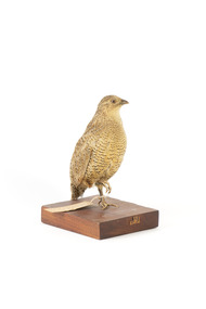 The Beechworth Burke Museum
Animal specimen - Brown Quail, Trustees of the Australian Museum, 1860-80
... The eye is red to yellow, the bill black and the legs and feet orange-yellow. In Tasmania, this species is called the Swamp Quail and tends to be larger and darker than mainland birds, with a pale yellow eye. ...The eye is red to yellow, the bill black and the legs and feet orange-yellow. In Tasmania, this species is called the Swamp Quail and tends to be larger and darker than mainland birds, with a pale yellow eye. ...This specimen is part of a collection of almost 200 animal specimens that were originally acquired as skins from various institutions across Australia, including the Australian Museum in Sydney and the National Museum of Victoria (known as Museums Victoria since 1983), as well as individuals such as amateur anthropologist Reynell Eveleigh Johns between 1860-1880. These skins were then mounted by members of the Burke Museum Committee and put-on display in the formal space of the Museum’s original exhibition hall where they continue to be on display. This display of taxidermy mounts initially served to instruct visitors to the Burke Museum of the natural world around them, today it serves as an insight into the collecting habits of the 19th century. Like many species of quail, the Brown Quail is often difficult to see, as it inhabits rank, overgrown grassy areas, often in damp, low-lying patches beside wetlands. They are difficult to flush from this cover, preferring to squat among the grass or run quickly off through the vegetation rather than fly off. As is the case with many species that inhabit dense habitats, the Brown Quail may be heard more often than it is seen, with its characteristically mournful two-note call whistle often heard at dawn and dusk. The Brown Quail is found across northern and eastern Australia, from the Kimberley region in Western Australia to Victoria and Tasmania, as well as in south-western Australia. It is also found in Papua New Guinea and Indonesia, and has been introduced to New Zealand. The Brown Quail feeds in the early morning or evening, on the ground, mainly on seeds and green shoots, but also on insects. In some area, quails will readily cross roads and may be seen feeding along roadsides.This specimen is part of a significant and rare taxidermy mount collection in the Burke Museum. This collection is scientifically and culturally important for reminding us of how science continues to shape our understanding of the modern world. They demonstrate a capacity to hold evidence of how Australia’s fauna history existed in the past and are potentially important for future environmental research. This collection continues to be on display in the Museum and has become a key part to interpreting the collecting habits of the 19th century. The Brown Quail is a small, plump ground-dwelling bird. It is variable in colour, ranging from red brown to grey brown with fine white streaks and black barring above, and chestnut brown below. The eye is red to yellow, the bill black and the legs and feet orange-yellow. In Tasmania, this species is called the Swamp Quail and tends to be larger and darker than mainland birds, with a pale yellow eye. Female Brown Quails are larger and may be more heavily marked with black and paler below than males. Young birds are like adult females, with less distinct markings and a dark brown eye.Label: 33. / Swamp Quail / See Catalogue, page 30 / Mount: 09/taxidermy, quail, brown quail, taxidermy bird, burke museum taxidermy -
 The Beechworth Burke Museum
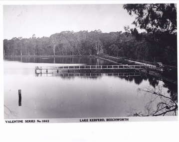
Postcard - Postcard - Reproduction, c.1930's - 1940's
... Burke Museum Lake Kerferd Hurdle Swamp Gold mining Beechworth Valentine Series Postcard Automobile trees jetty reflection car 5461 Obverse: Valentine Series No.1862/LAKE KERFERD, BEECHWORTH 5461 Reverse: BMM2961/5461 Black and white rectangular photograph printed on matte photographic paper. ...This photograph is a copy of the Valentine series postcard originally produced c.1920. The photograph copy was recorded made c. 1930's - 40's, depicting Lake Kerferd, Beechworth. Lake Kerferd was built in 1862 to assist for gold mining activities as it held the waters of the Hurdle Swamp. The retaining wall built to create Lake Kerferd is depicted in the photograph adjacent to a narrow road, the make of the single automobile shown is consistent with the date recorded. The photograph is socially significant due to the connection of Beechworth in the past, present and future. Originally developed for gold mining activities which is a strong research area as the foundation of many towns in Australia's history. Black and white rectangular photograph printed on matte photographic paper.5461 Obverse: Valentine Series No.1862/LAKE KERFERD, BEECHWORTH 5461 Reverse: BMM2961/5461burke museum, lake kerferd, hurdle swamp, gold mining, beechworth, valentine series postcard, automobile, trees, jetty, reflection, car -
 Phillip Island and District Historical Society Inc.
Photograph, 1954
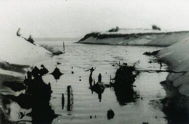
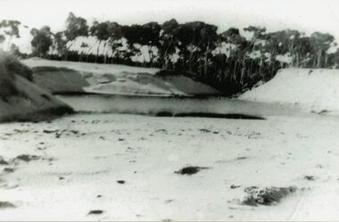
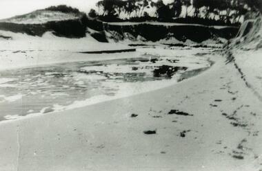
... Black & White Photograph of Woolamai Bight. Water and land masses. Swamp water broke through the channel to the beach....Phillip Island and District Historical Society Inc. phillip-island-and-the-bass-coast One of a collection of photos donated by Daryl Johns phillip island woolamai bight daryl johns Black & White Photograph of Woolamai Bight. Water and land masses. Swamp water broke through the channel to the beach. ...One of a collection of photos donated by Daryl JohnsBlack & White Photograph of Woolamai Bight. Water and land masses. Swamp water broke through the channel to the beach.phillip island, woolamai bight, daryl johns -
 Phillip Island and District Historical Society Inc.
Photograph, 1954
... Black & White photograph of Woolamai Bight - swamp water broken through channel onto the beach. ...Phillip Island and District Historical Society Inc. phillip-island-and-the-bass-coast One of a collection of photos donated by Daryl Johns woolamai bight phillip island daryl johns Black & White photograph of Woolamai Bight - swamp water broken through channel onto the beach. ...One of a collection of photos donated by Daryl JohnsBlack & White photograph of Woolamai Bight - swamp water broken through channel onto the beach. Channel scooped out.woolamai bight, phillip island, daryl johns -
 Phillip Island and District Historical Society Inc.
Photograph, 1954
... Black & White photograph of Woolamai Bight - swamp water breaking through the channel onto the beach....Phillip Island and District Historical Society Inc. phillip-island-and-the-bass-coast One of a collection of photos donated by Daryl Johns woolamai bight phillip island daryl johns Black & White photograph of Woolamai Bight - swamp water breaking through the channel onto the beach. ...One of a collection of photos donated by Daryl JohnsBlack & White photograph of Woolamai Bight - swamp water breaking through the channel onto the beach.woolamai bight, phillip island, daryl johns -
 Phillip Island and District Historical Society Inc.
Sketch
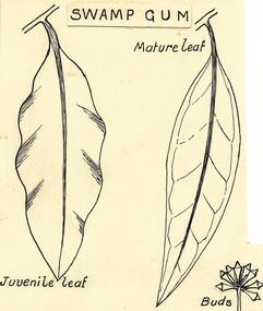
... leaves & buds of swamp gum...black...Phillip Island and District Historical Society Inc. phillip-island-and-the-bass-coast One of a collection of over 400 sketches & photographs in an album commenced in 1960 and presented to the Phillip Island & Westernport Historical Society by the Shire of Phillip Island local history illustrations pen & ink leaves & buds of swamp gum black & white sketch phillip island flora koalas Dr R T Patton John Jenner Bryant West Swamp Gum Sketch of the leaves and buds of the Swamp Gum - a favourite food of the Koala - drawn by Dr R T Patton, University of Melbourne. ...One of a collection of over 400 sketches & photographs in an album commenced in 1960 and presented to the Phillip Island & Westernport Historical Society by the Shire of Phillip IslandSketch of the leaves and buds of the Swamp Gum - a favourite food of the Koala - drawn by Dr R T Patton, University of Melbourne.Swamp Gumlocal history, illustrations, pen & ink, leaves & buds of swamp gum, black & white sketch, phillip island flora, koalas, dr r t patton, john jenner, bryant west -
 Phillip Island and District Historical Society Inc.
Photograph, Bryant West
... Photograph of Black Swan's nest and eggs in Rhyll Swamp....Phillip Island and District Historical Society Inc. phillip-island-and-the-bass-coast One of a collection of over 400 photographs in an album commenced in 1960 and presented to the Phillip Island & Westernport Historical Society by the Shire of Phillip Island local history photography photographs natural history - birds coloured photograph birds black swan nests john jenner bryant west Photograph of Black Swan's nest and eggs in Rhyll Swamp. Photograph Bryant West Verycolor Photo Labs Pty Ltd ...One of a collection of over 400 photographs in an album commenced in 1960 and presented to the Phillip Island & Westernport Historical Society by the Shire of Phillip IslandPhotograph of Black Swan's nest and eggs in Rhyll Swamp.local history, photography, photographs, natural history - birds, coloured photograph, birds, black swan, nests, john jenner, bryant west -
 Phillip Island and District Historical Society Inc.
Photograph, Birds of Phillip Island, pre 1970
... black swan's nest...birds eggs...rhyll swamp...Colour Photograph - Black Swan's nest and eggs. Rhyll Swamp. Bryant West Album...Phillip Island and District Historical Society Inc. phillip-island-and-the-bass-coast One of a collection of thirty-six photographs selected for representation in the National Photographic Index of Australian Birds local history photographs national history birds coloured photograph black swan's nest birds eggs rhyll swamp phillip island Colour Photograph - Black Swan's nest and eggs. ...One of a collection of thirty-six photographs selected for representation in the National Photographic Index of Australian BirdsColour Photograph - Black Swan's nest and eggs. Rhyll Swamp. Bryant West Albumlocal history, photographs, national history, birds, coloured photograph, black swan's nest, birds eggs, rhyll swamp, phillip island -
 Phillip Island and District Historical Society Inc.
Photographs, Rhyll Swamp Bird Life
... 441-01: 2nd year growth of Fathom Hen Seeds underwater dormant for 12 years. 441-02: Photo of Bill checking nesting boxes in Rhyll Swamp 441-03: Black & White photo of Bill & helper 441-04: Bee Hive at Rhyll Swamp 441-05: Royal Spoon Bill with 12 eggs 441-06: Ibis Hatchlings 441-07:Chestnut Teal Duck eggs at Rhyll Swamp 441-08: Photo of a painting of a Mallard Duck with 6 ducklings. ...Phillip Island and District Historical Society Inc. phillip-island-and-the-bass-coast Selection from a collection of photographs given to John Jansson from the Estate of Bill Barrett - Fisheries & Wildlife on Phillip Island Rhyll Swamp Phillip Island Mallard Duck Royal Swamp Hen Royal Spoon Bill Bill Barrett Chestnut Teal Duck eggs Beehive at Rhyll Swamp Fathom Hen Plants at Rhyll Swamp Nesting Boxes Rhyll Swamp John Jansson Descriptions written on back of photographs 441-01: 2nd year growth of Fathom Hen Seeds underwater dormant for 12 years. 441-02: Photo of Bill checking nesting boxes in Rhyll Swamp 441-03: Black & White photo of Bill & helper 441-04: Bee Hive at Rhyll Swamp 441-05: Royal Spoon Bill with 12 eggs 441-06: Ibis Hatchlings 441-07:Chestnut Teal Duck eggs at Rhyll Swamp 441-08: Photo of a painting of a Mallard Duck with 6 ducklings. ...Selection from a collection of photographs given to John Jansson from the Estate of Bill Barrett - Fisheries & Wildlife on Phillip Island441-01: 2nd year growth of Fathom Hen Seeds underwater dormant for 12 years. 441-02: Photo of Bill checking nesting boxes in Rhyll Swamp 441-03: Black & White photo of Bill & helper 441-04: Bee Hive at Rhyll Swamp 441-05: Royal Spoon Bill with 12 eggs 441-06: Ibis Hatchlings 441-07:Chestnut Teal Duck eggs at Rhyll Swamp 441-08: Photo of a painting of a Mallard Duck with 6 ducklings. Descriptions written on back of photographsrhyll swamp phillip island, mallard duck, royal swamp hen, royal spoon bill, bill barrett, chestnut teal duck eggs, beehive at rhyll swamp, fathom hen plants at rhyll swamp, nesting boxes rhyll swamp, john jansson -
 Bendigo Historical Society Inc.
Map - Bush Fire Control Map Bendigo District
... Also marked are houses, Post Offices, Police stations, bush fire brigades, water channels, swamps, marshes, dense, medium and scattered timber, aqueducts and reservoirs. Villages, districts and Towns are clearly marked. Printed in red, green, black...Also marked are houses, Post Offices, Police stations, bush fire brigades, water channels, swamps, marshes, dense, medium and scattered timber, aqueducts and reservoirs. Villages, districts and Towns are clearly marked. Printed in red, green, black ...A Bush Fire Control map is a valuable tool used by emergency services and communities to respond to respond to bushfires.Cream coloured parchment map showing roads, railway lines, telephone lines, rivers, creeks and water courses. Also marked are houses, Post Offices, Police stations, bush fire brigades, water channels, swamps, marshes, dense, medium and scattered timber, aqueducts and reservoirs. Villages, districts and Towns are clearly marked. Printed in red, green, black and blue. Very clear and easy to read. Undated.bush fires, bendigo area map -
 Bendigo Historical Society Inc.
Drawing - NORMAN PENROSE COLLECTION: BROWN FOLDER, 1955
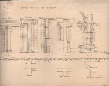
... Norman Penrose collection: large brown folder with wide black spine containing a page from Water Life with coloured sketches of the Murray Cod, the Azure Kingfisher and the Swamp-hen. ...Norman Penrose collection: large brown folder with wide black spine containing a page from Water Life with coloured sketches of the Murray Cod, the Azure Kingfisher and the Swamp-hen. ...Artwork. Norman Penrose collection: large brown folder with wide black spine containing a page from Water Life with coloured sketches of the Murray Cod, the Azure Kingfisher and the Swamp-hen. A page from the Herald-Sun, Feb 13, 1955 with ladies shoes on one side and the third article of a series of Lawrence of Arabia on the other. Notes and drawings of Ionic Order (Erectheion - Athens. North Portice). And Doric Order (Temple of Theseus. Athens. 5th Cent BC). Also Corinthian Order (Choragic Monument of Lysicrates. Athens). Plan of the Parthenon. Notes on perspective. Notes and illustrations on the Development of Buttress.drawing, pencil, norman penrose collection, water life, notes on drawings, herald-sun, ionic order, corinthian order, doric order -
 Flagstaff Hill Maritime Museum and Village
Document - Map, Department of Lands & Survey, Victoria / Panmure, 1942
... black; 'Victoria / Panmure", "No. 930 / Zone 6" Printed in red; “EMERGENCY EDITION”, “THIS MAP IS AN OFFICIAL DOCUMENT. IF FOUND, IT MUST BE HANDED / IN TO THE NEAREST MILITARY HEADQUARTERS OR POLICE STATION” Stamped: within concentric ovals (“- - - FOR SALE / PRICE 2/- / - - - - - OF THE ARMY”) Military map of Panmure, Victoria, Australia; part of the W.R. Angus Collection. Rectangular coloured map on cream paper for the Australian Army. Details include sea, waterways and land, contour lines, grid lines, names of districts, towns and roads, bridges, swamps ...This Emergency Edition of the map of Panmure, Victoria, is part of the W.R. Angus Collection. It was printed in 1942 during World War II. It is one of two maps donated to Flagstaff Hill Maritime Village by the family of Doctor William Roy Angus, who served as Surgeon Captain in the Australian Defence Department. The map was compiled for the Dept. of Army by the Dept. of Lands and Survey in Melbourne, prepared by the Australian Section of the Imperial General Staff, which was a British Government body created in 1907 to co-ordinate the defence of Britain and its Empire. It was printed by A.H.Q. Cartographic Company, Survey Corps, which was formed in 1941. The Corp changed its name to L.H.Q. Cartographic Company of Bendigo. In 1947 the name reverted back to the A.H.Q. Cartographic Company until 1955 when it became the A.H.Q. Survey Regiment. The W.R. Angus Collection includes historical medical equipment, surgical instruments and material once belonging to Dr Edward Ryan and Dr Thomas Francis Ryan, (both of Nhill, Victoria) as well as Dr Angus’ own belongings. The Collection’s history spans the medical practices of the two Doctors Ryan, from 1885-1926 plus that of Dr Angus who began practice in 1924. Dr. Angus served with the Australian Department of Defence as a Surgeon Captain during the Second World Was from 1942 to 1945. He served in Ballarat, Victoria, and in Bonegilla, N.S.W. until he suffering from a heart attack just before the war ended. ABOUT THE “W.R.ANGUS COLLECTION” - Doctor William Roy Angus M.B., B.S., Adel., 1923, F.R.C.S. Edin.,1928, was generally known as Dr Roy Angus. His working life included a position as a doctor with the Flying Doctor Service in Australia’s rural and remote areas. After many varied experiences Dr Angus and his family moved to Warrnambool in 1939 where he purchased “Birchwood,” the 1852 home and medical practice of Dr John Hunter Henderson. He was appointed on a part-time basis as Port Medical Officer in Warrnambool and held this position until the 1940’s when the government no longer required the service of a Port Medical Officer. Dr Angus was a surgeon at the Warrnambool Base Hospital 1939-1942. After further studies he commenced practice as an ophthalmologist in Warrnambool, pioneering in artificial eye improvements. He was Honorary Consultant Ophthalmologist to Warrnambool Base Hospital for 31 years and made monthly visits to Portland to perform eye surgery. Dr Angus and his wife Gladys were very involved in Warrnambool’s community with a strong interest in civic affairs. They were both involved in the creation of Flagstaff Hill Maritime Village, including the layout of the gardens. After his death on 28th March 1970 his family requested his practitioner’s plate, medical instruments and some personal belongings be displayed in the Port Medical Office surgery at Flagstaff Hill Maritime Village, and be called the “W. R. Angus Collection”. This Emergency Edition of the Map of Panmure is significant as an example of the documents prepared for the defence of Australia in World War 2. The Map is also significant for its connection between the Australian Army and the involvement of Dr WR Angus as a Surgeon in the Medical Services during World War II. The W.R. Angus Collection is significant for still being located at the site it is connected with, Doctor Angus being the last Port Medical Officer in Warrnambool. The collection of medical instruments and other equipment is culturally significant, being an historical example of medicine, administration, household equipment and clothing from late 19th to mid-20th century. Dr Angus assisted Dr Tom Ryan, a pioneer in the use of X-rays and in ocular surgery. The collection includes Dr Angus’s Army objects and is significant as an example of items issued to Doctors and Surgeons in the Medical Services of the Australian Army in World War IIMilitary map of Panmure, Victoria, Australia; part of the W.R. Angus Collection. Rectangular coloured map on cream paper for the Australian Army. Details include sea, waterways and land, contour lines, grid lines, names of districts, towns and roads, bridges, swamps, rail lines, cuttings, tracks, buildings (including blacksmiths), pumps, lighthouses, telegraph, telephones and electric transmission lines, and fire stations. The map has margin notes that include distances in miles to nearby towns. The map was compiled for the Dept. of Army by the Dept. of Lands and Survey in Melbourne, prepared by the Australian Section, Imperial General Staff and printed by A.H.Q. Cartographic Company, Melbourne in 1942. Crown Copyright Reserved. Inscriptions in red print state that it is and Emergency Edition and an Official document. An oval purple stamp includes the price.Printed in black; 'Victoria / Panmure", "No. 930 / Zone 6" Printed in red; “EMERGENCY EDITION”, “THIS MAP IS AN OFFICIAL DOCUMENT. IF FOUND, IT MUST BE HANDED / IN TO THE NEAREST MILITARY HEADQUARTERS OR POLICE STATION” Stamped: within concentric ovals (“- - - FOR SALE / PRICE 2/- / - - - - - OF THE ARMY”)flagstaff hill, warrnambool, flagstaff hill maritime museum, maritime museum, shipwreck coast, flagstaff hill maritime village, great ocean road, dr w r angus, dr ryan, warrnambool base hospital, flying doctor, surgeon captain, australian department of defence, royal australian army, world war 2, map panmure 1942, roy angus, port medical officer, nhill base hospital, military map, emergency map, military service australian army, department of army, department of lands and survey, a.h.q. cartographic company melbourne, panmure 1942, australian section, imperial general staff -
 Flagstaff Hill Maritime Museum and Village
Document - Map, Department of Lands & Survey, Victoria / Port Campbell, 1942
... black; 'Victoria / Port Campbell", "No. 932 / Zone 6" Printed in red; “EMERGENCY EDITION”, “THIS MAP IS AN OFFICIAL DOCUMENT. IF FOUND, IT MUST BE HANDED / IN TO THE NEAREST MILITARY HEADQUARTERS OR POLICE STATION” Stamped: within concentric ovals (“- - - FOR SALE / PRICE 2/- / - - - - - OF THE ARMY”) Military map of Port Campbell, Victoria, Australia; part of the W.R. Angus Collection. Rectangular coloured map on cream paper for the Australian Army. Details include sea, waterways and land, contour lines, grid lines, names of districts, towns and roads, bridges, swamps ...This Emergency Edition of the map of Port Campbell, Victoria, is part of the W.R. Angus Collection. It was printed in 1942 during World War II. It is one of two maps donated to Flagstaff Hill Maritime Village by the family of Doctor William Roy Angus, who served as Surgeon Captain in the Australian Defence Department. The map was compiled for the Dept. of Army by the Dept. of Lands and Survey in Melbourne, prepared by the Australian Section of the Imperial General Staff, which was a British Government body created in 1907 to co-ordinate the defence of Britain and its Empire. It was printed by A.H.Q. Cartographic Company, Survey Corps, which was formed in 1941. The Corp changed its name to L.H.Q. Cartographic Company of Bendigo. In 1947 the name reverted back to the A.H.Q. Cartographic Company until 1955 when it became the A.H.Q. Survey Regiment. The W.R. Angus Collection includes historical medical equipment, surgical instruments and material once belonging to Dr Edward Ryan and Dr Thomas Francis Ryan, (both of Nhill, Victoria) as well as Dr Angus’ own belongings. The Collection’s history spans the medical practices of the two Doctors Ryan, from 1885-1926 plus that of Dr Angus who began practice in 1924. Dr Angus served with the Australian Department of Defence as a Surgeon Captain during the Second World Was from 1942 to 1945. He served in Ballarat, Victoria, and in Bonegilla, N.S.W. until he suffering from a heart attack just before the war ended. ABOUT THE “W.R.ANGUS COLLECTION” - Doctor William Roy Angus M.B., B.S., Adel., 1923, F.R.C.S. Edin.,1928, was generally known as Dr Roy Angus. His working life included a position as a doctor with the Flying Doctor Service in Australia’s rural and remote areas. After many varied experiences Dr Angus and his family moved to Warrnambool in 1939 where he purchased “Birchwood,” the 1852 home and medical practice of Dr John Hunter Henderson. He was appointed on a part-time basis as Port Medical Officer in Warrnambool and held this position until the 1940’s when the government no longer required the service of a Port Medical Officer. Dr Angus was a surgeon at the Warrnambool Base Hospital 1939-1942. After further studies he commenced practice as an ophthalmologist in Warrnambool, pioneering in artificial eye improvements. He was Honorary Consultant Ophthalmologist to Warrnambool Base Hospital for 31 years and made monthly visits to Portland to perform eye surgery. Dr Angus and his wife Gladys were very involved in Warrnambool’s community with a strong interest in civic affairs. They were both involved in the creation of Flagstaff Hill Maritime Village, including the layout of the gardens. After his death on 28th March 1970 his family requested his practitioner’s plate, medical instruments and some personal belongings be displayed in the Port Medical Office surgery at Flagstaff Hill Maritime Village, and be called the “W. R. Angus Collection”. This Emergency Edition of the Map of Port Campbell is significant as an example of the documents prepared for the defence of Australia in World War 2. The Map is also significant for its connection between the Australian Army and the involvement of Dr WR Angus as a Surgeon in the Medical Services during World War II. The W.R. Angus Collection is significant for still being located at the site it is connected with, Doctor Angus being the last Port Medical Officer in Warrnambool. The collection of medical instruments and other equipment is culturally significant, being an historical example of medicine, administration, household equipment and clothing from late 19th to mid-20th century. Dr Angus assisted Dr Tom Ryan, a pioneer in the use of X-rays and in ocular surgery. The collection includes Dr Angus’s Army objects and is significant as an example of items issued to Doctors and Surgeons in the Medical Services of the Australian Army in World War IIMilitary map of Port Campbell, Victoria, Australia; part of the W.R. Angus Collection. Rectangular coloured map on cream paper for the Australian Army. Details include sea, waterways and land, contour lines, grid lines, names of districts, towns and roads, bridges, swamps, rail lines, cuttings, tracks, buildings (including blacksmiths), pumps, lighthouses, telegraph, telephones and electric transmission lines, and fire stations. The map has margin notes that include distances in miles to nearby towns. The map was compiled for the Dept. of Army by the Dept. of Lands and Survey in Melbourne, prepared by the Australian Section, Imperial General Staff and printed by A.H.Q. Cartographic Company, Melbourne in 1942. Crown Copyright Reserved. Inscriptions in red print state that it is and Emergency Edition and an Official document. An oval purple stamp includes the price.Printed in black; 'Victoria / Port Campbell", "No. 932 / Zone 6" Printed in red; “EMERGENCY EDITION”, “THIS MAP IS AN OFFICIAL DOCUMENT. IF FOUND, IT MUST BE HANDED / IN TO THE NEAREST MILITARY HEADQUARTERS OR POLICE STATION” Stamped: within concentric ovals (“- - - FOR SALE / PRICE 2/- / - - - - - OF THE ARMY”)flagstaff hill, warrnambool, flagstaff hill maritime museum, maritime museum, shipwreck coast, flagstaff hill maritime village, great ocean road, dr w r angus, dr ryan, warrnambool base hospital, nhill base hospital, flying doctor, surgeon captain, map port campbell 1942, roy angus, port medical officer, military map, emergency map, australian department of defence, royal australian army, military service australian army, department of army, department of lands and survey, world war 2, a.h.q. cartographic company melbourne, australian section, imperial general staff, port campbell 1942 -
Glenelg Shire Council Cultural Collection
Postcard - Postcard - Hand drawn image of swamp and local Indigenous people, Vanda Savill, c. 1985
... Black and white postcard, hand drawn by Vanda Savill. Image of swamp and local indigenous people....Glenelg Shire Council Cultural Collection History House Cliff Street Portland great-ocean-road Black and white postcard, hand drawn by Vanda Savill. Image of swamp and local indigenous people. ...Black and white postcard, hand drawn by Vanda Savill. Image of swamp and local indigenous people. -
Glenelg Shire Council Cultural Collection
Photograph - Photograph - Aerial view of Thomas Borthwick and Sons abattoir and Walock Swamp, Nov-55
... Black and white photograph. Aerial view of taken from the S.W, of T.B.& S abattoir and Walock Swamp. ...Port of Portland Archives TB and S abattoir Walock Swamp Front: (no inscriptions) Back: 'AIRSPY PHOTO' CD PRATT 86 McCracken St ref No2/B/73 Essendon Phone Fx 2840 Victoria Australia Black and white photograph. ...Port of Portland Authority archives.Front: (no inscriptions) Back: 'AIRSPY PHOTO' CD PRATT 86 McCracken St ref No2/B/73 Essendon Phone Fx 2840 Victoria Australiaport of portland archives, tb and s abattoir, walock swamp -
Glenelg Shire Council Cultural Collection
Book, Robertson & Mullens Ltd. Melbourne 1941, Seashore Swamp and Bush: Exploring Nature's Mysteries, 1941
... Black text and graphics. Part of dust jacket fixed to front cover and inner front cover. Seashore Swamp and Bush: Exploring Nature's Mysteries Book Book Jackson, Ada M.S.C. ...Ex - Jenkin's Lending LibraryLight green cloth-covered cardboard covers and spine. Black text and graphics. Part of dust jacket fixed to front cover and inner front cover.Front: Label on rear cover. 'Jenkin's Lending Library. Bookseller, Authorised Newsagent and Stationery, Box 28, Phone 48 Bentinck and Julia Streets Portland Label on rear cover and stamps within leaves. -
Glenelg Shire Council Cultural Collection
Programme - Programme - Wallacedale Racing Club Picnic, 1914, Hamilton Spectator, Apr-14
... Wallacedale Condah Condah swamp Four page cardboard programme for the Wallacedale Racing Club's Picnic Meeting on April 18, 1914. Printing in black ...Formerly from the Bower Bird Museum collection in Heywood. Wallacedale is in western Victorian 28km sw of Hamilton. It was created by draining the Condah Swamp. After WWII the population declined and in the 1970s the school closed.Four page cardboard programme for the Wallacedale Racing Club's Picnic Meeting on April 18, 1914. Printing in black. Pages held together with sellotape.wallacedale, condah, condah swamp -
Glenelg Shire Council Cultural Collection
Book, Harleigh Severne, Chums: A Tale for the Youngsters, c. 1892
... Swamp/ 8-7-60 (blue pen, title page) Brown cloth-covered binding. Front cover has pictures of swords, guns and ancors, with lettering and design in gold. Title and author on spine in black ...Brown cloth-covered binding. Front cover has pictures of swords, guns and ancors, with lettering and design in gold. Title and author on spine in black lettering. Gilt-edged pages. 312pp.fiction, childrens literature, 1800s -
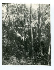 Orbost & District Historical Society
black and white photograph, first half 20th century
... swamps of southern Queensland and along the east coast of Australia and it occurs further south than any other Australian palm species. It is the only palm that is found naturally in Victoria. The early settlers supplemented their meagre rations with the hearts of the Cabbage Tree Palm. This is the southernmost stand of Cabbage Tree Palms in Australia and the only location in Victoria where these palms grow naturally. This is a pictorial record of a rare native Australian palm. cabbage-tree-palm-east-gippsland A black ...Livistona australis - the Cabbage Tree Palm, is a fan palm that grows naturally in the lowland forest and swamps of southern Queensland and along the east coast of Australia and it occurs further south than any other Australian palm species. It is the only palm that is found naturally in Victoria. The early settlers supplemented their meagre rations with the hearts of the Cabbage Tree Palm.This is the southernmost stand of Cabbage Tree Palms in Australia and the only location in Victoria where these palms grow naturally. This is a pictorial record of a rare native Australian palm.A black / white photograph of small palm trees in a dense bush surrounding.cabbage-tree-palm-east-gippsland