Showing 33022 items matching "boggy-creek-bridge-nowa-nowa"
-
 Orbost & District Historical Society
black and white photograph, c1920-1954
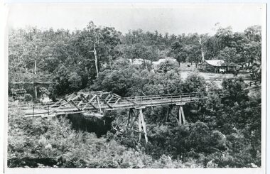
... This is a copy of "THE BRIDGE AT BOGGY CREEK, NOWA NOWA, LAKE TYERS." which is a Rose Stereograph Co postcard. ...A large black / white photograph of a large wooden bridge across a creek. There is a house and outbuildings in the background on the right. ...on back - "Boggy Creek bridge - Nowa Nowa 1887 LaTrobe Collection"...Nowa Nowa, East Gippsland, Victoria, Australia...Orbost & District Historical Society Ruskin Street Orbost gippsland This is a copy of "THE BRIDGE AT BOGGY CREEK, NOWA NOWA, LAKE TYERS." which is a Rose Stereograph Co postcard. ...This is a copy of "THE BRIDGE AT BOGGY CREEK, NOWA NOWA, LAKE TYERS." which is a Rose Stereograph Co postcard. Boggy Creek Bridge was built in 1916 as part of the Bairnsdale to Orbost extension to the main Gippsland Railway, and is situated in the middle of the township of Nowa Nowa, crossing a steep-sided and well-timbered creek-valley. This section of the line closed in 1987. This bridge plays a major part in the identity and history of the town of Nowa Nowa, This item is associated with the East Gippsland Railway.A large black / white photograph of a large wooden bridge across a creek. There is a house and outbuildings in the background on the right. It is in a bush setting. on back - "Boggy Creek bridge - Nowa Nowa 1887 LaTrobe Collection"boggy-creek-bridge east-gippsland-railway -
 Orbost & District Historical Society
magazine, It Could Only Happen in Nowa Nowa, 1988
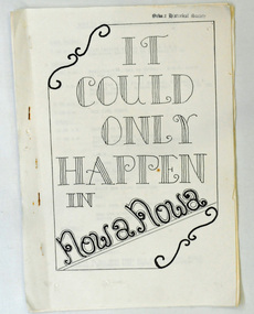
... It Could Only Happen in Nowa Nowa...This magazine seems to be a single issue produced for use at the Nowa Nowa Back To in 1988....A magazine titled "It Could Only Happen In Nowa Nowa". It contains a program for the Back To Nowa Nowa event in 1988. ...Nowa Nowa, East Gippsland, Victoria, Australia...Orbost & District Historical Society Ruskin Street Orbost gippsland This magazine seems to be a single issue produced for use at the Nowa Nowa Back To in 1988. This magazine seems to be a single issue produced for use at the Nowa Nowa Back To in 1988 and records some of the history of Nowa Nowa. magazine nowa-nowa A magazine titled "It Could Only Happen In Nowa Nowa". ...This magazine seems to be a single issue produced for use at the Nowa Nowa Back To in 1988.This magazine seems to be a single issue produced for use at the Nowa Nowa Back To in 1988 and records some of the history of Nowa Nowa.A magazine titled "It Could Only Happen In Nowa Nowa". It contains a program for the Back To Nowa Nowa event in 1988. It contains stories of times past. The sheets are stapled and are black print on white.magazine nowa-nowa -
 Lakes Entrance Historical Society
Album - Photograph Album, LERHS, Scenes at Nowa Nowa Victoria c2000, 2000
... Scenes at Nowa Nowa Victoria c2000...These photographs were illustrations in The Houses of Nowa Nowa in the year 2000...Folder containing colour photographs of scenes of Nowa Nowa Victoria. Please visit the L.E History Centre to view all photos in this folder....Nowa Nowa, Victoria, Australia...Lakes Entrance Historical Society 4 Marine Parade Lakes Entrance gippsland These photographs were illustrations in The Houses of Nowa Nowa in the year 2000 Settlement Towns Folder containing colour photographs of scenes of Nowa Nowa Victoria. ...These photographs were illustrations in The Houses of Nowa Nowa in the year 2000Folder containing colour photographs of scenes of Nowa Nowa Victoria. Please visit the L.E History Centre to view all photos in this folder.settlement, towns -
 Lakes Entrance Historical Society
Photograph, Lakes Post Newspaper, Mrs Hilda Rule: Nowa Nowa Victoria, 1990 c
... Mrs Hilda Rule: Nowa Nowa Victoria...Also a colour photograph of Nowa Nowa memorial cairn before the fence was built around it....Colour photograph showing Mrs Hilda Rule in front of the memorial cairn beside the RSL Hall after Anzac Day service at Nowa Nowa Victoria...Nowa Nowa, Victoria, Australia...Lakes Entrance Historical Society 4 Marine Parade Lakes Entrance gippsland Also a colour photograph of Nowa Nowa memorial cairn before the fence was built around it. ...Also a colour photograph of Nowa Nowa memorial cairn before the fence was built around it.Colour photograph showing Mrs Hilda Rule in front of the memorial cairn beside the RSL Hall after Anzac Day service at Nowa Nowa Victoriadefence services, memorials -
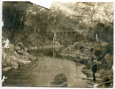
 Orbost & District Historical Society
photograph / postcard, early 20th century
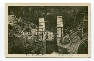
... Boggy Creek Bridge was built in 1916 as part of the Bairnsdale to Orbost extension to the main Gippsland Railway, and is situated in the middle of the township of Nowa Nowa, crossing a steep-sided and well-timbered creek-valley. ...A black / white photograph on a postcard showing the construction of a railway bridge across a creek. The end pylons are evident and there is scaffolding on both sides of the creek. ...on front of postcard - caption - " Boggy Creek, Nowa Nowa, W.S. Vogt, Bairnsdale"...Nowa Nowa, East Gippsland, Victoria, Australia...This bridge plays a major part in the identity and history of the town of Nowa Nowa, since Boggy Creek’s steep sided valley divides the township into two components. boggy-creek-bridge vogt-w.s. railway-bridges east-gippsland-railway railway-construction train on front of postcard - caption - " Boggy Creek, Nowa Nowa, W.S. ...Boggy Creek Bridge was built in 1916 as part of the Bairnsdale to Orbost extension to the main Gippsland Railway, and is situated in the middle of the township of Nowa Nowa, crossing a steep-sided and well-timbered creek-valley. This section of the line closed in 1987.This item is a pictorial record of the construction of the Boggy Creek railway bridge on the East Gippsland line. This bridge plays a major part in the identity and history of the town of Nowa Nowa, since Boggy Creek’s steep sided valley divides the township into two components. A black / white photograph on a postcard showing the construction of a railway bridge across a creek. The end pylons are evident and there is scaffolding on both sides of the creek. Two copies of a black / white photograph showing the construction of a railway bridge across a cree. The end pylons are evident and there is scaffolding on both sides of the creek. There is a steam train on the rail track.on front of postcard - caption - " Boggy Creek, Nowa Nowa, W.S. Vogt, Bairnsdale"boggy-creek-bridge vogt-w.s. railway-bridges east-gippsland-railway railway-construction train -
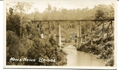 Orbost & District Historical Society
black and white photograph, first half 20th century
... This appears to be the Boggy Creek bridge and to have been taken at Nowa Nowa. ...A black / white photograph / postcard of a tall railway bridge, with concrete pylons in the centre,There is a creek below....on front - bottom left - " NOWA NOWA BRIDGE"...Nowa Nowa, East Gippsland, Victoria, Australia...Orbost & District Historical Society Ruskin Street Orbost gippsland This appears to be the Boggy Creek bridge and to have been taken at Nowa Nowa. ...This appears to be the Boggy Creek bridge and to have been taken at Nowa Nowa. The Boggy Creek Bridge was built in 1916 as part of the Bairnsdale to Orbost extension to the main Gippsland Railway, and is situated in the middle of the township of Nowa Nowa, crossing a steep-sided and well-timbered creek-valley. This section of the line closed in 1987.This bridge plays a major part in the identity and history of the town of Nowa Nowa, since Boggy Creek’s steep sided valley divides the township into two components. It is part of the East Gippsland Railway line.A black / white photograph / postcard of a tall railway bridge, with concrete pylons in the centre,There is a creek below.on front - bottom left - " NOWA NOWA BRIDGE"boggy-creek-railway-bridge nowa-nowa railway-bridge east-gippsland-railway orbost-bairnsdale-railway -
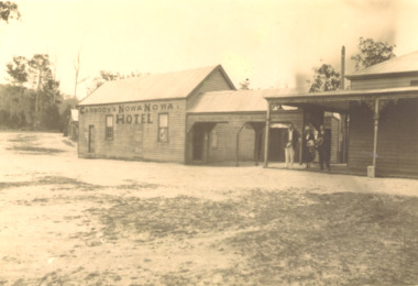
 Orbost & District Historical Society
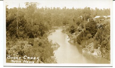
black / white photograph, late 19th - early 29th century
... The building in this photograph of Boggy Creek is probably the first Nowa Nowa Hotel built by Moses Faithfull, in 1890. ...The banks of the creek are well-vegetated....on front - bottom left -"BOGGY CREEK NOWA NOWA"...Nowa Nowa, East Gippsland, Victoria, Australia...This is a pictorial record of Nowa Nowa in the late 19th century. Boggy-Creek-Nowa-Nowa on front - bottom left -"BOGGY CREEK NOWA NOWA" A black / white photograph / postcard of a creek with a building on the rightside. a windmillis to the left. ...The building in this photograph of Boggy Creek is probably the first Nowa Nowa Hotel built by Moses Faithfull, in 1890. Moses Faithful came to Australia from England with his parents on the Royal Consort in 1844. After living at Bulla, Pakenham and Wurruk he and his wife moved to Hospital Creek in about 1885 where he took up the first selection of land at Upper Hospital Creek. As well as farming he built the first hotel at Nowa Nowa in 1890. He had charge of the hotel until 1895 when he sold to Mary Stirling. Moses died on 8th July 1901, aged 66, at the residence of his son-in-law, David Price, at Newmerella, and buried in the Orbost cemetery.This hotel was built in 1890 and doubled as a coaching stop on the inland route. Settlement grew up around the hotel. It was sold 1895 to Mary Stirling who husband own the land the hotel stood on. The hotel burned down on 29 July 1955. This is a pictorial record of Nowa Nowa in the late 19th century.A black / white photograph / postcard of a creek with a building on the rightside. a windmillis to the left. The banks of the creek are well-vegetated.on front - bottom left -"BOGGY CREEK NOWA NOWA"boggy-creek-nowa-nowa -
Lakes Entrance Historical Society
Book, Rule Hilda, Back to Nowa Nowa, 1980
... Back to Nowa Nowa...A short history of the timber township of Nowa Nowa, East Gippsland Victoria....Nowa Nowa, Victoria, Australia...Township Settlers Timber Industry Schools Transport A short history of the timber township of Nowa Nowa, East Gippsland Victoria. Back to Nowa Nowa Book Rule Hilda ...A short history of the timber township of Nowa Nowa, East Gippsland Victoria.township, settlers, timber industry, schools, transport -
 Orbost & District Historical Society
Photograph - Nowa Nowa photos, Stanley Vogt, c.1920s
... The Hotel shown in 2716.1 was located near the crossing of Boggy Creek. Boggy Creek Boggy Creek (2716.2) which has a wonderful deep gorge which was and still is a major natural attraction. ...Two b/w photographs/postcards of Nowa Nowa. 2716.1 Two cars and a group of people in front of a building. ...2716.1 Nowa Nowa Hotel. S Vogt 2716.2 Boggy Creek, Nowa Nowa Stanley Vogt, Bairnsdale ...These photos are significant because they show aspects of Nowa Nowa in the c. 1920s. Nowa Nowa Boggy Creek 2716.1 Nowa Nowa Hotel. ...Nowa Nowa is at the top of Lake Tyers. The Princes Highway from Orbost to Bairnsdale travels through Nowa Nowa. From the earliest times of white settlement, Nowa Nowa developed as a stopping-off point on the Highway, and also as a tourist and holiday location, in association with the Buchan caves and Lakes Entrance. These photos show aspects of travel and tourism, possibly 1920s. The Hotel shown in 2716.1 was located near the crossing of Boggy Creek. Boggy Creek Boggy Creek (2716.2) which has a wonderful deep gorge which was and still is a major natural attraction. These photos are significant because they show aspects of Nowa Nowa in the c. 1920s.Two b/w photographs/postcards of Nowa Nowa. 2716.1 Two cars and a group of people in front of a building. One vehicle has no roof. This postcard has a piece torn out at the bottom right hand corner. 2716.2 Eight people standing as a group on a rock platform beside a creek. The people are on the r.h.s. of the photo. In the background is a bushland setting and a rocky creek. 2716.1 Nowa Nowa Hotel. S Vogt 2716.2 Boggy Creek, Nowa Nowa Stanley Vogt, Bairnsdale nowa nowa, boggy creek -
Lakes Entrance Historical Society
Book, Blakeman, Elizabeth Harley, Judith, Houses of Nowa Nowa in the year 2000, 2000
... Houses of Nowa Nowa in the year 2000...A description of all houses still standing at Nowa Nowa,Victoria in 2000 and the families living in them....Nowa Nowa, Victoria, Australia...Houses of Nowa Nowa in the year 2000 Book Blakeman, Elizabeth Harley, Judith ...A description of all houses still standing at Nowa Nowa,Victoria in 2000 and the families living in them.township, buildings, settlement -
Lakes Entrance Historical Society
Book, Johnston Chris, Nowa Nowa Workshop Report East Gippsland Heritage Workshop, 1993
... Nowa Nowa Workshop Report East Gippsland Heritage Workshop...Report on 1993 heritage workshop condcted at Nowa Nowa, Victoria where 97 historic areas and cultural landscapes were identified....Nowa Nowa, Victoria, Australia...Nowa Nowa Workshop Report East Gippsland Heritage Workshop Book Johnston Chris ...Report on 1993 heritage workshop condcted at Nowa Nowa, Victoria where 97 historic areas and cultural landscapes were identified.heritage, social history -
Lakes Entrance Historical Society
Photograph, Lakes Post Newspaper, Badminton Championship Nowa Nowa Victoria 1999, 1/10/1999 12:00:00 AM
... Badminton Championship Nowa Nowa Victoria 1999...Colour photograph of Marcus Prior, Jill Collings Ted Collings and Geordie Collings after Badminton Championship at Nowa Nowa Victoria...Nowa Nowa, Victoria, Australia...Lakes Entrance Historical Society 4 Marine Parade Lakes Entrance gippsland Sports Clubs Colour photograph of Marcus Prior, Jill Collings Ted Collings and Geordie Collings after Badminton Championship at Nowa Nowa Victoria Badminton Championship Nowa Nowa Victoria 1999 Photograph Lakes Post Newspaper ...Colour photograph of Marcus Prior, Jill Collings Ted Collings and Geordie Collings after Badminton Championship at Nowa Nowa Victoriasports, clubs -
 Lakes Entrance Historical Society
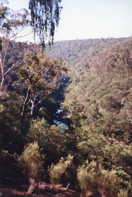
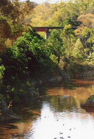
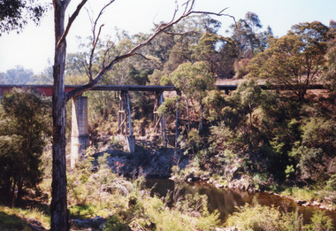
Photograph - Boggy Creek Gorge, 1999
... Boggy Creek Gorge cuts through volcanics just before it meets salty water at Nowa Nowa Arm of Lake Tyers....Colour photograph from a vantage point of the distant Boggy Creek Gorge surrounded by steep tree and scrub covered ranges. ...Nowa Nowa, Victoria, Australia...Nowa Nowa Victoria Photograph Boggy Creek Gorge ...Boggy Creek Gorge cuts through volcanics just before it meets salty water at Nowa Nowa Arm of Lake Tyers.Colour photograph from a vantage point of the distant Boggy Creek Gorge surrounded by steep tree and scrub covered ranges. Nowa Nowa Victoriavegetation, waterways -
Lakes Entrance Historical Society
Book, Judy Hartley, Nowa Nowa A Journey through the first 100 Years, 2023
... Nowa Nowa A Journey through the first 100 Years...Book of Photographs and Stories of History of Nowa Nowa...Book has photos of Nowa Nowa on cover with 73 pages...Lakes Entrance Historical Society 4 Marine Parade Lakes Entrance gippsland Book of Photographs and Stories of History of Nowa Nowa History People Book of Photographs and Stories of History of Nowa Nowa Book has photos of Nowa Nowa on cover with 73 pages Nowa Nowa A Journey through the first 100 Years Book Judy Hartley Tabintha Landcaster Black Rainbow ...Book of Photographs and Stories of History of Nowa NowaBook has photos of Nowa Nowa on cover with 73 pagesnon-fictionBook of Photographs and Stories of History of Nowa Nowahistory, people -
 Orbost & District Historical Society
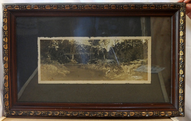
framed black and white photograph, C1920
... Boggy Creek Bridge was built in 1916 as part of the Bairnsdale to Orbost extension to the main Gippsland Railway, and is situated in the middle of the township of Nowa Nowa, crossing a steep-sided and well-timbered creek-valley. ...A black / white photograph of a bridge across a river in the bush. It is under glass in a brown wooden frame which has gold decorated edges. ...on front of photograph - "Nowa Nowa Creek, Gippsland, Victoria, Sears, Copyright"...Nowa Nowa, East Gippsland, Victoria, Australia...Boggy-Creek-Nowa-Nowa East-Gippsland-railway bridge-rail on front of photograph - "Nowa Nowa Creek, Gippsland, Victoria, Sears, Copyright" A black / white photograph of a bridge across a river in the bush. ...Boggy Creek Bridge was built in 1916 as part of the Bairnsdale to Orbost extension to the main Gippsland Railway, and is situated in the middle of the township of Nowa Nowa, crossing a steep-sided and well-timbered creek-valley. This section of the line closed in 1987. This item is a pictorial record of the Boggy Creek railway bridge on the East Gippsland line. This bridge plays a major part in the identity and history of the town of Nowa Nowa, since Boggy Creek’s steep sided valley divides the township into two components.A black / white photograph of a bridge across a river in the bush. It is under glass in a brown wooden frame which has gold decorated edges. There appears to be a man sitting on rocks in the right front foreground.on front of photograph - "Nowa Nowa Creek, Gippsland, Victoria, Sears, Copyright"boggy-creek-nowa-nowa east-gippsland-railway bridge-rail -
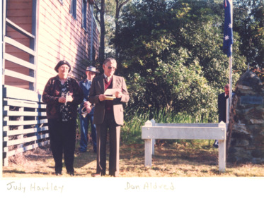 Lakes Entrance Historical Society
Photograph, Judy Hartley, Don Aldred Anzac Day Service: Nowa Nowa Victoria, 1999
... Judy Hartley, Don Aldred Anzac Day Service: Nowa Nowa Victoria...Colour photograph of Judy Hartley and RSL President and Don Aldred speaking at Anzac Day Service at Nowa Nowa Victoria. plus a photo of two young boys at same ceremony...Nowa Nowa, Victoria, Australia...Lakes Entrance Historical Society 4 Marine Parade Lakes Entrance gippsland Memorials Return Soldiers League Ceremony Colour photograph of Judy Hartley and RSL President and Don Aldred speaking at Anzac Day Service at Nowa Nowa Victoria. plus a photo of two young boys at same ceremony Judy Hartley, Don Aldred Anzac Day Service: Nowa Nowa Victoria Photograph ...Colour photograph of Judy Hartley and RSL President and Don Aldred speaking at Anzac Day Service at Nowa Nowa Victoria. plus a photo of two young boys at same ceremonymemorials, return soldiers league, ceremony -
 Lakes Entrance Historical Society
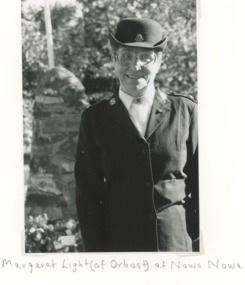
Photograph, Lakes Post Newspaper, Margaret Light/Gavin Robinson Nowa Nowa Victoria, 1996
... Margaret Light/Gavin Robinson Nowa Nowa Victoria...Black and white photograph of Mrs Margaret Light Salvation Army Officer from Orbost who led prayers at Anzac Day service at Nowa Nowa Victoria. Plus a photo of Gavin Robinson playing bugle at same event...Nowa Nowa, Victoria, Australia...Lakes Entrance Historical Society 4 Marine Parade Lakes Entrance gippsland Return Soldiers League Black and white photograph of Mrs Margaret Light Salvation Army Officer from Orbost who led prayers at Anzac Day service at Nowa Nowa Victoria. Plus a photo of Gavin Robinson playing bugle at same event Margaret Light/Gavin Robinson Nowa Nowa Victoria Photograph Lakes Post Newspaper ...Black and white photograph of Mrs Margaret Light Salvation Army Officer from Orbost who led prayers at Anzac Day service at Nowa Nowa Victoria. Plus a photo of Gavin Robinson playing bugle at same eventreturn soldiers league -
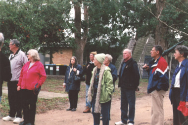 Lakes Entrance Historical Society
Photograph, M Holding, Mingling Waters Park Nowa Nowa Victoria, 1/06/2014 12:00:00 AM
... Mingling Waters Park Nowa Nowa Victoria...Colour photograph of group of LERHS and Family History members on a visit to Mingling Waters, at Nowa Nowa Victoria. Also three similar colour photographs taken at same time 04848.1, .2, .3 10 x 15 cm...Nowa Nowa, Victoria, Australia...Lakes Entrance Historical Society 4 Marine Parade Lakes Entrance gippsland Mike Ryan talking to members Anne Macarthur, Barb Shugg, Noel and Sidney Matthews, Des Thomas, Malcolm, Bev Bullen, Joy and Bruce Wilmshurst, Meg Wiblin, Robyn and Geoff Purdy, Judy Davies Fundraising Clubs Historical Society Caravan Parks Colour photograph of group of LERHS and Family History members on a visit to Mingling Waters, at Nowa Nowa Victoria. Also three similar colour photographs taken at same time 04848.1, .2, .3 10 x 15 cm Mingling Waters Park Nowa Nowa Victoria Photograph M Holding ...Mike Ryan talking to members Anne Macarthur, Barb Shugg, Noel and Sidney Matthews, Des Thomas, Malcolm, Bev Bullen, Joy and Bruce Wilmshurst, Meg Wiblin, Robyn and Geoff Purdy, Judy DaviesColour photograph of group of LERHS and Family History members on a visit to Mingling Waters, at Nowa Nowa Victoria. Also three similar colour photographs taken at same time 04848.1, .2, .3 10 x 15 cmfundraising, clubs, historical society, caravan parks -
 Orbost & District Historical Society
black and white photograph, first half 20th century
... boggy-creek-bridge-nowa-nowa...This appears to be the Boggy Creek bridge and to have been taken at Nowa Nowa. ...A black / white photograph of a bridge across a creek. A young man in a suit is standing in the foreground....Nowa Nowa, East Gippsland, Victoria, Australia...Orbost & District Historical Society Ruskin Street Orbost gippsland This appears to be the Boggy Creek bridge and to have been taken at Nowa Nowa. ...This appears to be the Boggy Creek bridge and to have been taken at Nowa Nowa. The Boggy Creek Bridge was built in 1916 as part of the Bairnsdale to Orbost extension to the main Gippsland Railway, and is situated in the middle of the township of Nowa Nowa, crossing a steep-sided and well-timbered creek-valley. This section of the line closed in 1987.This bridge plays a major part in the identity and history of the town of Nowa Nowa, since Boggy Creek’s steep sided valley divides the township into two components. It is part of the East Gippsland Railway line.A black / white photograph of a bridge across a creek. A young man in a suit is standing in the foreground.boggy-creek-bridge-nowa-nowa -
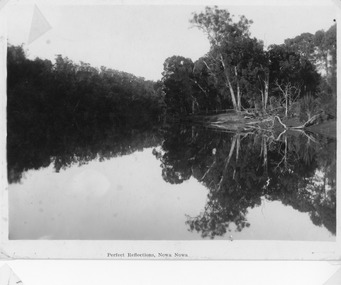 Lakes Entrance Historical Society
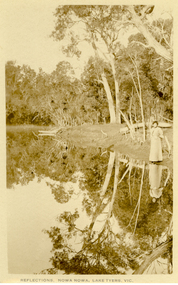
Postcard - Nowa Nowa. Victoria, c1907
... Black and white giant postcard showing a tranquil lake scene at Nowa Nowa. Timbered banks are reflected in the calm surface of the lake. ...Perfect reflections Nowa Nowa...Nowa Nowa, Victoria, Australia...Lakes Entrance Historical Society 4 Marine Parade Lakes Entrance gippsland Waterways Vegetation Perfect reflections Nowa Nowa Black and white giant postcard showing a tranquil lake scene at Nowa Nowa. ...Black and white giant postcard showing a tranquil lake scene at Nowa Nowa. Timbered banks are reflected in the calm surface of the lake. Lake Tyers VictoriaPerfect reflections Nowa Nowawaterways, vegetation -
 Lakes Entrance Historical Society
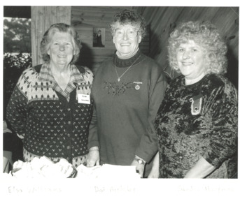
Photograph - CWA Nowa Nowa Victoria, Lakes Post Newspaper, 1/07/1996 12:00:00 AM
... Elsa Williams, Dot Appleby and Sandra Haynes at Association Day at Nowa Nowa Victoria...Black and white photograph of Nowa Nowa CWA at Association Day at Nowa Nowa Victoria 1996...Nowa Nowa, Victoria, Australia...Lakes Entrance Historical Society 4 Marine Parade Lakes Entrance gippsland Elsa Williams, Dot Appleby and Sandra Haynes at Association Day at Nowa Nowa Victoria Clubs Social History Black and white photograph of Nowa Nowa CWA at Association Day at Nowa Nowa Victoria 1996 Photograph CWA Nowa Nowa Victoria Lakes Post Newspaper ...Elsa Williams, Dot Appleby and Sandra Haynes at Association Day at Nowa Nowa VictoriaBlack and white photograph of Nowa Nowa CWA at Association Day at Nowa Nowa Victoria 1996clubs, social history -
 Lakes Entrance Historical Society
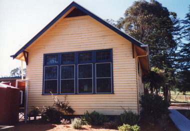
Photograph - Nowa Nowa School 1999
... The Nowa Nowa School building was opened in 1918, by M Cameron MP (from Vision and Realisation Vol 3, p 1127)....Colour photograph of Nowa Nowa Primary School 3738 Nowa Nowa Victoria...Nowa Nowa, Victoria, Australia...Schools Buildings Colour photograph of Nowa Nowa Primary School 3738 Nowa Nowa Victoria Photograph Nowa Nowa School 1999 ...The Nowa Nowa School building was opened in 1918, by M Cameron MP (from Vision and Realisation Vol 3, p 1127).Colour photograph of Nowa Nowa Primary School 3738 Nowa Nowa Victoriaschools, buildings -
 Federation University Historical Collection
Postcard, Howard D. Bulmer, Reflections, Nowa Nowa, Lake Tyers, Victoria
... Reflections, Nowa Nowa, Lake Tyers, Victoria...Tall eucalypts stand guard as you drive into this small village.The fresh waters of Boggy Creek and the tidal waters of Lake Tyers meet here. ...Tall eucalypts stand guard as you drive into this small village.The fresh waters of Boggy Creek and the tidal waters of Lake Tyers meet here. ...Nowa Nowa is located in Victoria on the Princes Highway between Lakes Entrance & Orbost. Tall eucalypts stand guard as you drive into this small village.The fresh waters of Boggy Creek and the tidal waters of Lake Tyers meet here. In the past its history was of logging. Black and white post card showing a lady in long skirt standing on the banks of a river with Australian eucalypts (gum tress) in the background and reflected in the water. nowa nowa, lake tyers, trees, river -
 Lakes Entrance Historical Society
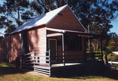
Photograph - Nowa Nowa Recreation Centre 1999
... This hall was originally at Tostaree where it was opened in 1919 as State School no. 3994, worked part time with Upper Hospital Creek, Canni Creek. Later used as a public hall for meetings, dances etc. ...Colour photograph of the Gym at Nowa Nowa. Officially the Nowa Nowa Health and Fitness Centre, a small timber half, corrugated iron gable roof, short ramp leading to roofed veranda across front entry. ...Nowa Nowa, Victoria, Australia...Nowa Nowa Victoria Photograph Nowa Nowa Recreation Centre 1999 ...This hall was originally at Tostaree where it was opened in 1919 as State School no. 3994, worked part time with Upper Hospital Creek, Canni Creek. Later used as a public hall for meetings, dances etc. When no longer being used it was donated to Nowa Nowa RSL as clubrooms, later became CWA Hall, finally in mid 1990's fitted out as Recreation Centre.Colour photograph of the Gym at Nowa Nowa. Officially the Nowa Nowa Health and Fitness Centre, a small timber half, corrugated iron gable roof, short ramp leading to roofed veranda across front entry. Nowa Nowa Victoriahistoric buildings, recreation facilities -
 Lakes Entrance Historical Society
Photograph - Carmody's Hotel, Nowa Nowa Victoria c1915
... John Carmody took over the Nowa Nowa Hotel from previous lease holder David Duggan in 1914....Black and white photograph of Carmody's Hotel at Nowa Nowa Victoria...Nowa Nowa, Victoria, Australia...Memorials Shipwrecks Hotels Black and white photograph of Carmody's Hotel at Nowa Nowa Victoria Photograph Carmody's Hotel, Nowa Nowa Victoria c1915 ...John Carmody took over the Nowa Nowa Hotel from previous lease holder David Duggan in 1914.Black and white photograph of Carmody's Hotel at Nowa Nowa Victoriamemorials, shipwrecks, hotels -
University of Melbourne, Burnley Campus Archives
Photograph - Colour 35mm slides, Kodachrome, D-B Plots Nowa-Nowa, 1969
... D-B Plots Nowa-Nowa...Box of colour slides labelled "D-B Plot Nos 1 & 2 Nowa-Nowa August 1969....University of Melbourne, Burnley Campus Archives 500 Yarra Boulevard Richmond melbourne nowa-nowa db plots excursion Box of colour slides labelled "D-B Plot Nos 1 & 2 Nowa-Nowa August 1969. ...Box of colour slides labelled "D-B Plot Nos 1 & 2 Nowa-Nowa August 1969.nowa-nowa, db plots, excursion -
 Lakes Entrance Historical Society
Photograph, 2012
... Colour photograph of the railway bridge over Boggy Creek at Nowa Nowa. Bridge is built on combination of solid concrete piers, timber trestle piers on concrete to flood level, and timber piers. ...Nowa Nowa, Victoria, Australia...Lakes Entrance Historical Society 4 Marine Parade Lakes Entrance gippsland Date made December 2012 Bridges Waterways Transport Colour photograph of the railway bridge over Boggy Creek at Nowa Nowa. ...Date made December 2012Colour photograph of the railway bridge over Boggy Creek at Nowa Nowa. Bridge is built on combination of solid concrete piers, timber trestle piers on concrete to flood level, and timber piers. Nowa Nowa Victoriabridges, waterways, transport -
 Lakes Entrance Historical Society
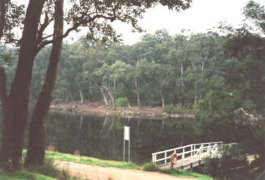
Photograph - Northern End Lake Tyers at Nowa Nowa Victoria 2014, M Holding
... The area was the port of Nowa Nowa during early years of settlement and timber industry....Colour photograph of flating jetty at top of North Arm of Lake Tyers at Nowa Nowa Victoria...Nowa Nowa, Victoria, Australia...Topography Gippsland Lakes Colour photograph of flating jetty at top of North Arm of Lake Tyers at Nowa Nowa Victoria Photograph Northern End Lake Tyers at Nowa Nowa Victoria 2014 M Holding ...The area was the port of Nowa Nowa during early years of settlement and timber industry.Colour photograph of flating jetty at top of North Arm of Lake Tyers at Nowa Nowa Victoriatopography, gippsland lakes -
Lakes Entrance Historical Society
Book, Jeanes, Ken; Stewart, Sara; Goldsmith, Les; Hartley, Judy; Sztynda, Keryn, Nowa Nowa Primary School Centenary 1912-2012, 2012
... Nowa Nowa Primary School Centenary 1912-2012...A history of Nowa Nowa Primary School, East Gippsland, Victoria. ...Lakes Entrance Historical Society 4 Marine Parade Lakes Entrance gippsland Schools Education A history of Nowa Nowa Primary School, East Gippsland, Victoria. ...A history of Nowa Nowa Primary School, East Gippsland, Victoria. Compiled from official records and personal reminiscences. Contains list of students.schools, education -
 Lakes Entrance Historical Society
Photograph - Boggy Creek bridge Nowa Nowa, Victoria, 1998
... Colour photograph of the railway bridge over Boggy Creek, showing the bridge high above the waterway, rocky terrain and scrubby vegetation. ...Nowa Nowa, Victoria, Australia...Nowa Nowa, Victoria, Photograph Boggy Creek bridge Nowa Nowa, Victoria ...Re Heritage StudyColour photograph of the railway bridge over Boggy Creek, showing the bridge high above the waterway, rocky terrain and scrubby vegetation. Nowa Nowa, Victoria,bridges, waterways, transport