Showing 2008 items matching "bogong high plains"
-
 Kiewa Valley Historical Society
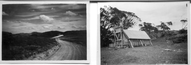
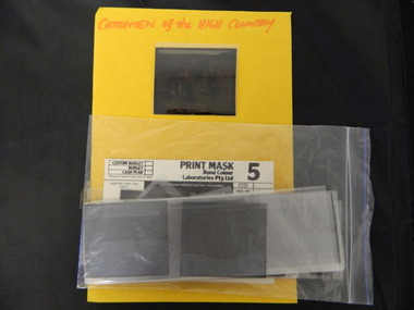
18 small black and white photographs of the Bogong High Plains, 1948
... 18 small black and white photographs of the Bogong High...Bogong High Plains; R G Thorn; SECV; Kiewa Hydro Electric...These photos of the Bogong High Plains were all taken... on the Bogong High Plains....Bogong High Plains, Kiews Region, Victoria, Australia... Centre 31 Bogong High Plains Rd Mt Beauty high-country ...These photos of the Bogong High Plains were all taken by Ronald George Thorn who was a cadet engineer with the State Electricity Commission. He worked on the Kiewa scheme from 1948 to 1950 doing overhead line construction and maintenance plus electrical design and drawing work. They are from his personal collection and a record of his time in the Kiewa area.Pictorial history of personal involvement in the the early days of the Kiewa Scheme.18 small black and white photographs all taken on the Bogong High Plains.Photo 1 Wallace's Hut. Photo 2 Ruined Castle - Looking towards Pretty Valley December 1948. Photo 3 Ruined Castle - Looking towards Pretty Valley December 1948. Photo 4 Ruined Castle - Looking Down Valley December 1948. Photo 5 - Mt. McKay from Ruined Castle October 1948. Photo 6 View from Rocky Valley Camp October 1948. Photo 7 Mt. Feather Top from Ruined Castle October 1948. Photo 8 View from Ruined Castle looking downwards towards Beauty October 1948. Photo 9 Rocky River from gauging station October 1948. Photo 10 Rocky Valley River from main road October 1948. Photo 11 View along little Arthur Fire Track October 1948. Photo 12 View along main road. Looking towards Beauty Valley October 1948. Photo 13 View from Little Arthur Fire Track October 1948. Photo 14 Frying Pan Spur from Rocky Valley Road October 1948. Photo 15 Mt. Bogong from Big Hill Fire Track October 1948. Photo 16 View from Big Hill Fire Track October 1948. Photo 17 Mt. Feathertop from Ruined Castle October 1948. Photo 18 Mt. Fainter from Ruined Castle October 1948. (All of the above is hand written on the back of photos in ink). bogong high plains; r g thorn; secv; kiewa hydro electric scheme; pictorial history -
 Kiewa Valley Historical Society
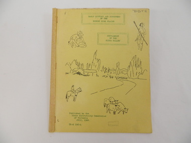
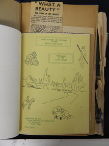
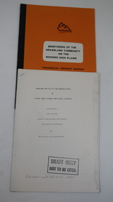
Book - Bogong High Plains x2, Early History and Discovery of the Bogong High Plains, 1968
... Book - Bogong High Plains x2...Early History and Discovery of the Bogong High Plains...bogong high plains. state electricity commission of... of the early history of the Bogong High Plains and the origin of names... and Discovery / of the / Bogong High Plains" on cover top centre... Centre 31 Bogong High Plains Rd Mt Beauty high-country The State ...The State Electricity Commission of Victoria constructed the Kiewa Hydro Electric Scheme in the north east of Victoria. Mr R.M. Duncan prepared the notes. He was a member of the S.E.C. Kiewa Branch from 1949 - 1966. This book was commissioned by the State Electricity Commission of Victoria. It consists of the early history of the Bogong High Plains and the origin of names of places and creeks in the area.This book was researched in 1968 by Mr R.M. Duncan who worked for the S.E.C. on the Kiewa Hydro Electric Scheme from 1949 to 1966. His sources were the Melbourne Public Library, the Victorian Historical Society, the North Eastern Victorian Historical Society and the Dept. of Crown Lands & Survey, Melbourne. The book is an accurate history of the Bogong High Plains given the available records at the time. Yellow cardboard covered book with black sketches and green print. 9 one-sided pages held together by 3 staples and taped over the staples. One - has sheets enclosed "The Three Floras of Bogong" and "General Geology of the Kiewa Area". 6 copies including 1 that is a photocopyDDTS hand written on front cover "Early History and Discovery / of the / Bogong High Plains" on cover top centre. "Settlement / of the / Kiewa-Valley" on cover towards the top slightly to the right. "Published by the / State Electricity Commission / of Victoria / July, 1968" on cover bottom left. "TR-K 596-4" on cover bottom left.bogong high plains. state electricity commission of victoria. kiewa. aborigines. kiewa valley. mullindollingong pastoral run. flora. geology -
 Falls Creek Historical Society
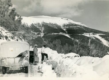
Photograph - Between Wallace's Hut and SEC cottage, Bogong High Plains
... Between Wallace's Hut and SEC cottage, Bogong High Plains...Between Wallace's Hut and SEC cottage, Bogong High Plains...Bogong High Plains... Wallace's Hut and SEC cottage, Bogong High Plains... Wallace's Hut and SEC cottage, Bogong High Plains Between Wallace's ...MEYER COLLECTION - FALLS CREEK PHOTOS In 1947 a determined group of like-minded State Electricity Commission (SEC) staff including Ray Meyer, the chief surveyor of the Kiewa Hydro-Electric Scheme, had a common interest that revolved around the skiing potential of the snow-covered high plains which included what is now the resort of Falls Creek. The six SEC employees, Toni St Elmo, Ray Meyer, Jack Minogue, Lloyd Dunn, Adrian Ruffenacht and Dave Gibson (together with their families) banded together to secretly build a 'hut' that was the first ski lodge at Falls Creek. Using a road built in 1930s to gain access to Falls Creek, their hut project was carried out in secret as efforts by other skiers were blocked by H.H.C. Williams – the engineer in charge of the Hydro Scheme. In 1946 Ray Meyer made a trip to the Lands Office in Melbourne. He came away with a 99-year lease on three acres that was ideally suited for a hut designed by Lloyd Dunn. Adrian Ruffenacht (Design Engineer for the KHS) had suggested where the group should build because of easy access to a spring for water. Much of the building material required was scavenged from derelict huts on the high plains. Due to the need for secrecy, the determined group worked on the hut in the evenings and weekends to avoid detection. During the building period the group had met at Echidna Rock (now known as Eagle Rock) where Skippy St Elmo announced, "This is my favourite ‘Skyline’.” And so the first lodge in the area at Falls Creek Ski Resort came into existence. With the development of the International Poma in the 1970s, the Skyline Lodge, which was sited between the ski-lift’s pole one and pole two, was demolished. However, the legacy of Ray Meyer, Toni St Elmo, Jack Minogue, Lloyd Dunn, Adrian Ruffenacht and Dave Gibson and Skyline lives on in the vibrant atmosphere of Falls Creek Resort. The MEYER COLLECTION documents developments on the Kiewa Hydro Scheme and their life at Falls Creek from the mid 1930s to 1960s.This image is significant because it depicts aspects of the life of a pioneering family of Falls Creek and the founders of "Skyline", the first lodge at Falls Creek.A black and white image of three people travelling between Wallace's Hut and SEC cottage, Bogong High Plainsfalls creek, wallace's hut, bogong high plains -
 Kiewa Valley Historical Society
Booklet - Bogong High Plains & Kiewa Valley, Early History & Discovery of the Bogong High Plains & Settlement of the Kiewa Valley, July 1968
... Booklet - Bogong High Plains & Kiewa Valley...Early History & Discovery of the Bogong High Plains...bogong high plains...A brief history of the area including the Bogong High... Centre 31 Bogong High Plains Rd Mt Beauty high-country A brief ...A brief history of the area including the Bogong High plains including aborigines and cattlemen. Settlement of the Kiewa Valley including cattlemen and families. A list of the Origin of names of places in the valley.SECV published this booklet using research resources available at the time and using current knowledge with regard to naming of places where the SECV worked and 'created'.Light cardboard cover with 3 staples and with 9 pages printed on one side. Text is boxed. Front cover has 5 simple sketches each of which covers the topics included in the booklet."Dick Puttyfoot" on front coverstate electricity commission of victoria., kiewa hydro electric scheme, kiewa valley, bogong high plains -
 Falls Creek Historical Society
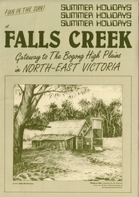
Booklet - Falls Creek: Gateway to the Bogong High Plains in North-East Victoria
... Falls Creek: Gateway to the Bogong High Plains in North...Falls Creek: Gateway to the Bogong High Plains in North...Bogong High Plains... Creek 'Gateway to the Bogong High Plains'. Dark green printed... to the Bogong High Plains'. Dark green printed text and images ...A part of a yearly marketing and information material promoting Falls Creek region for the summer holidays. It focuses on Falls Creek's location in the High Plains and its connection to the Bogong National Park. Large amounts of information about activities, facilities and regulations for the use of Park facilities are included,This item is important because it documents seasonal activities at Falls Creek Alpine ResortGreen A4 size brochure for summer holiday program at Falls Creek 'Gateway to the Bogong High Plains'. Dark green printed text and images on lighter green card paper, with image of Wallaces Hut framed at bottom of page and titles above. Opens to A3 size with internal and back pages of images and information for Summer Holidays at Falls Creek. falls creek, bogong high plains, bogong national park, northeast victoria -
 Kiewa Valley Historical Society
Photographs and copies of photographs of the pack horses and early horsemen who transported supplies to outposts in the Bogong High Plains, via cattle tracks before access roads were made
... Bogong High Plains, via cattle tracks before access roads were...pack horses; Bogong High Plains; survey posts; supplies... for the SECV in the Bogong High Plains. Before any roads were built... and survey posts in the Bogong High Plains, via the rough cattlemen’s...Bogong High Plains, Victoria, Australia... Centre 31 Bogong High Plains Rd Mt Beauty high-country In the mid ...In the mid to late 1930’s survey outposts were established to plot the early stages of the Kiewa Hydro Electric System for the SECV in the Bogong High Plains. Before any roads were built, the old cattleman’s tracks were used with packhorses to deliver supplies, wages and mail and collect timesheets and correspondence from the workmen and dam builders living in canvas tents and at the outlying survey posts. The trip up the mountain was long and hard and dangerous for both horse and man Most of the men of the survey teams were not bush-men and were often ill equipped for the harsh weather and living conditions of bush camping, often arriving in their city clothes ready for work. The tent city at Bogong was destroyed by bush fires in 1939 after which an access road was built from Mt Beauty to transport building materials for more permanent dwellings for workmen. Pack horses continued to be used for transporting goods etc. to workers further up the mountain.Without the work of horsemen and their pack horses providing supplies and communications for outlying outposts, surveying and early planning for the Kiewa Valley Hydro Electric scheme could not have gone ahead and the dams and power stations which support the system could not have been constructed. The Hydro-electric scheme, and the workers who planned and built it play a major part in the early history of the Kiewa Valley and many original families still remain living, or have ties with the local area.: Set of 21 black and white photographs and copies of photographs depicting the pack horses and the men who handled them, transporting supplies and correspondence to the outlying camps and survey posts in the Bogong High Plains, via the rough cattlemen’s tracks. Photographs also show the early tent camps of the workers. Some photos mounted on A4 white paper. Some photos enlarged to A3 poster size for display1. Handwritten on back – Max Lawrence 2. -8 No inscriptions 9. Handwritten on back- Packing in supplies for early workers of the Kiewa Hydro scheme. There were no roads in the early days of the scheme 10. Printed on bottom of photo- Roper’s cattle on road below Howman’s Gap 11. Handwritten on back – Roper’s et al about to leave for the high plains 12. Printed under photo- Syd Ryder at the Pretty Valley Cut-Out (JBR) 13-16. No markings 17. Printed under photo- Gwen Talbot visits the Camp area. 1937 18. Handwritten on back- 14/1 Barbara Talbot 19. No markings 20-21. No markings 22. Printed under photo- STATE ELECTRICITY COMMISSION OF VICTORIA. Date: 15-3-45 Time: 8.0pm No: K 1838 Kiewa Hydro-Electric Works, Investigations 1944-1945 – Survey Camp at Young’s Hut pack horses; bogong high plains; survey posts; supplies delivery -
 Falls Creek Historical Society
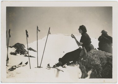
Photograph - Joan Meyer at Bogong High Plains
... Joan Meyer at Bogong High Plains...Joan Meyer at Bogong High Plains...Bogong High Plains... and Basalt Hill, Bogong High Plains. Wilkinson’s Hut (Wilkie... lodge at Falls Creek. Falls Creek Joan Meyer Bogong High Plains ...MEYER COLLECTION - FALLS CREEK PHOTOS In 1947 a determined group of like-minded State Electricity Commission (SEC) staff including Ray Meyer, the chief surveyor of the Kiewa Hydro-Electric Scheme, had a common interest that revolved around the skiing potential of the snow-covered high plains which included what is now the resort of Falls Creek. The six SEC employees, Toni St Elmo, Ray Meyer, Jack Minogue, Lloyd Dunn, Adrian Ruffenacht and Dave Gibson (together with their families) banded together to secretly build a 'hut' that was the first ski lodge at Falls Creek. Using a road built in 1930s to gain access to Falls Creek, their hut project was carried out in secret as efforts by other skiers were blocked by H.H.C. Williams – the engineer in charge of the Hydro Scheme. In 1946 Ray Meyer made a trip to the Lands Office in Melbourne. He came away with a 99-year lease on three acres that was ideally suited for a hut designed by Lloyd Dunn. Adrian Ruffenacht (Design Engineer for the KHS) had suggested where the group should build because of easy access to a spring for water. Much of the building material required was scavenged from derelict huts on the high plains. Due to the need for secrecy, the determined group worked on the hut in the evenings and weekends to avoid detection. During the building period the group had met at Echidna Rock (now known as Eagle Rock) where Skippy St Elmo announced, "This is my favourite ‘Skyline’.” And so the first lodge in the area at Falls Creek Ski Resort came into existence. With the development of the International Poma in the 1970s, the Skyline Lodge, which was sited between the ski-lift’s pole one and pole two, was demolished. However, the legacy of Ray Meyer, Toni St Elmo, Jack Minogue, Lloyd Dunn, Adrian Ruffenacht and Dave Gibson and Skyline lives on in the vibrant atmosphere of Falls Creek Resort. The MEYER COLLECTION documents developments on the Kiewa Hydro Scheme and their life at Falls Creek from the mid 1930s to 1960s.These images are significant because they depict aspects of the life of a pioneering family of Falls Creek and the founders of "Skyline", the first lodge at Falls Creek.Two black and white images of John Meyer skiing near Wilkie and Basalt Hill, Bogong High Plains. Wilkinson’s Hut (Wilkie) was built for the SEC in the summer of 1932-3 to accommodate the snow research program manager. The cottage was sited next to a hydro-meteorological station, set on stilts above the snow. It was not a refuge hut but a permanent residence for all of the year. The work carried out there included operation of a meteorological station at the cottage, measuring the snow depth and density along two pole lines, and operating stream gauging stations in the area. The engineers stationed there included Adrian Rufenacht (1934-6), and Norwegian Martin Romuld (1936-42) Romuld was a champion skier, constructing a ski-jump and a grass tennis court near the hut during his residency. Adrian was one of the founders of 'Skyline". The hut was sold in 1948 to the Victorian Ski Club and renamed Wilkinson Lodge. Robert Wood Wilkinson, best known as 'Wilkie, was the 'Father figure' of Victorian skiing. Robert Wood Wilkinson died on May 22, 1939. The hut was resold some 12 years later to the Melbourne Bushwalkers club. In 1983, the National Parks Service described the building as an old SEC hut which had been purchased and, afterwards, maintained and occupied solely by the Melbourne Bushwalking Club. Wilkie Hut survived the 2003 bushfires but burnt down one year later (January 2004) in a cooking accident.falls creek, joan meyer, bogong high plains -
 Kiewa Valley Historical Society
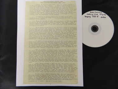
Diary Extract - Trip to Bogong High Plains Xmas 1934 & DVD photos, original diary 1934
... Diary Extract - Trip to Bogong High Plains Xmas 1934 & DVD...melbourne women's walking club. bogong high plains. camping... High Plains in the mid 1930's before the Kiewa Hydro Electric... the Melbourne Women's Walking Club trip to the Bogong High Plains... "Melbourne Women's Walking Club / Bogong High Plains / Dec. 1934... Centre 31 Bogong High Plains Rd Mt Beauty high-country ...The Melbourne Women's Walking Club enjoyed bush walking as a hobby travelling to the north east of Victoria, using pack horses and camping on a 9 day hike. One of the woman, 'Bill' describes each day in detail - what they did, where they went and what they saw giving an insight into walking and the Bogong High Plains in the mid 1930's before the Kiewa Hydro Electric Scheme opened up the area. The diary mentions a photo being taken by Mr Blackwell on the 9th day, New Year's Eve 'from a lovely bush track from which, looking back at intervals we got our final glimpse of Fainter. 5 miles from from our destination'.Historic: This extract from the diary of 'Bill', a member of the Melbourne Women's Walking Club gives an insight into walking in the mid 1930's and describes the Bogong High Plains as it was then before it was opened up with a road built during the Kiewa Hydro Electric Scheme. It describes the area in summer including the flora & fauna, cattle grazing & cattlemen, the huts, the gauges set up by the State Electricity Commission of Victoria, the people working up there, the weather and the lifestyle of the walking group - their food, duties, swimming etc.. Six double sided typed photocopied yellow pages describing the Melbourne Women's Walking Club trip to the Bogong High Plains at Christmas in 1934. Also one page photocopied of the programme for Year 1934-35 with an arrow pointing to the above trip and a page with a photocopied sepia photo of the "Melbourne Women's Walking Club / Bogong High Plains / Dec. 1934. DVD 12 photos of the trip arrow showing trip from Programme. Title of photo "Melbourne Women's Walking Club / Bogong High Plains / Dec. 1934melbourne women's walking club. bogong high plains. camping. pack horses. cattlemen's huts. -
 Kiewa Valley Historical Society
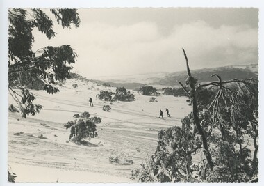
Photographs –Collection of 10 copies and original black and white photographs and printed articles relating to skiing on the Bogong High Plains
... Bogong High Plains...secv; bogong high plains; skiers; falls creek; tourism... on Bogong High Plains with temporary buildings and tents...Bogong High Plains, Victoria, Australia... Centre 31 Bogong High Plains Rd Mt Beauty high-country After ...After World War II, the Kiewa Hydro-Electric Scheme was started in the Kiewa River Valley by the State Electricity Commission of Victoria. On land previously used only for summer cattle grazing in the natural alpine grasslands, the first ski lodge was built in 1948 by workers from the hydro scheme as skiing was a popular recreation. Many of the hydro employees were of European background and had grown up enjoying skiing and snow sports in their homelands and were keen to continue to pursue their winter sports interests. The first lift, a rope tow, was built in 1951 at Falls Creek and the first chairlift in Australia was constructed there in 1957. Two T-Bars were opened in 1961. In 1964, the Victorian Municipal Directory recorded that Falls Creek had 29 ski club lodges and 16 commercial lodges. The area became a popular tourist destination for both winter and summer sports.: Employees of the State Electricity Commission of Victoria in the Kiewa River Valley were the earliest skiers on the Bogong High Plains and built one of the first ski lodges at Falls Creek. They were amongst those pivotal in the development of the skiing and tourist industry at Falls Creek and on the Bogong High Plains. Collection of 10 copies and original black and white photographs and printed articles relating to skiing on the Bogong High Plains. Some pieces have been enlarged to A3 poster size copies for display purposes 1. Copy of black and white photograph of group of skiers at Falls Creek 2. Copy of photograph of early skier on Bogong High Plains with temporary buildings and tents in the background 3. Copy of photograph of 3 skiers on Mt McKay 4. Copy of SECV photograph of Rocky Valley Camp under snow 5. Early sepia photograph of Falls Creek village with skiers in the foreground 6. Copy of a page from booklet (SECV?) promoting the benefits of owning a holiday home in the Bogong Village area 7. Copy of a page from booklet (SECV?) promoting the benefits of holidaying in and around Falls Creek/Mt Beauty 8. Panoramic view of ski fields with skis in the foreground 9. Photograph of young skier (identity unknown) 10. Photograph of 2 male skiers (identity unknown) performing a small jump 1. Bogong Ski Club Members & Friends 1944 2. Jack Neve – electrician. Rocky Valley 3. 17.5.55 Skiers ascending Mt McKay 4. State Electricity Commission of Victoria. Date:17.8.55 No:K8132 Kiewa Hydro Electric Works. Rocky Valley Camp – From Engineering Office 5 & 9 No markings 6 & 7 Short article relating to photos on each page 8. Handwritten signature on rear of photo (Sandra Conea) 10 Faded unreadable photographers stamp and handwritten numbers 6875 on rear secv; bogong high plains; skiers; falls creek; tourism -
 Kiewa Valley Historical Society
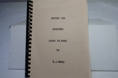
Book - Notes on Bogong High Plains by E. J. Minty, Notes on Bogong High Plains by E. J. Minty
... Book - Notes on Bogong High Plains by E. J. Minty...Notes on Bogong High Plains by E. J. Minty...Bogong High Plains... Centre 31 Bogong High Plains Rd Mt Beauty high-country The book ...The book includes detailed accounts in 4 sections of 1. History and Exploration 2. General Geology 3. Vegetation and slide set index 4. Climate ...Important knowledge/study for the construction of the Kiewa Hydro Electric Scheme on the Bogong High Plains.Cream cardboard cover book with black spiral binding. Title printed in black on cover. 46 pages printed on both sides includes diagrams. Clear blue plastic sheet as last page.e. j. minty, bogong high plains, kiewa hydro electric scheme -
 Falls Creek Historical Society
Photograph - Mt McKay, Bogong High Plains
... Mt McKay, Bogong High Plains...Mt McKay, Bogong High Plains...Bogong High Plains... KcKay Bogong High Plains Ray Meyer Phil Gabillot A black ...MEYER COLLECTION - FALLS CREEK PHOTOS In 1947 a determined group of like-minded State Electricity Commission (SEC) staff including Ray Meyer, the chief surveyor of the Kiewa Hydro-Electric Scheme, had a common interest that revolved around the skiing potential of the snow-covered high plains which included what is now the resort of Falls Creek. The six SEC employees, Toni St Elmo, Ray Meyer, Jack Minogue, Lloyd Dunn, Adrian Ruffenacht and Dave Gibson (together with their families) banded together to secretly build a 'hut' that was the first ski lodge at Falls Creek. Using a road built in 1930s to gain access to Falls Creek, their hut project was carried out in secret as efforts by other skiers were blocked by H.H.C. Williams – the engineer in charge of the Hydro Scheme. In 1946 Ray Meyer made a trip to the Lands Office in Melbourne. He came away with a 99-year lease on three acres that was ideally suited for a hut designed by Lloyd Dunn. Adrian Ruffenacht (Design Engineer for the KHS) had suggested where the group should build because of easy access to a spring for water. Much of the building material required was scavenged from derelict huts on the high plains. Due to the need for secrecy, the determined group worked on the hut in the evenings and weekends to avoid detection. During the building period the group had met at Echidna Rock (now known as Eagle Rock) where Skippy St Elmo announced, "This is my favourite ‘Skyline’.” And so the first lodge in the area at Falls Creek Ski Resort came into existence. With the development of the International Poma in the 1970s, the Skyline Lodge, which was sited between the ski-lift’s pole one and pole two, was demolished. However, the legacy of Ray Meyer, Toni St Elmo, Jack Minogue, Lloyd Dunn, Adrian Ruffenacht and Dave Gibson and Skyline lives on in the vibrant atmosphere of Falls Creek Resort. The MEYER COLLECTION documents developments on the Kiewa Hydro Scheme and their life at Falls Creek from the mid 1930s to 1960s.This image is significant because it depicts activities in the life of a pioneering family of Falls Creek area.A black and white photo of Phil Gabillot and Ray Meyer looking towards Mt. McKay and the High Plains. Phil Gabillot was in charge of "Trois Es', the French tunnel construction company and Ray Meyer was Chief Surveyor of the Kiewa Scheme at this time.falls creek, victorian snowfields, mt kckay, bogong high plains, ray meyer, phil gabillot -
 Falls Creek Historical Society
Photograph - Near Wallace's Hut, Bogong High Plains
... Near Wallace's Hut, Bogong High Plains...Near Wallace's Hut, Bogong High Plains...Bogong High Plains... lodge at Falls Creek. Falls Creek Bogong High Plains Wallace's ...MEYER COLLECTION - FALLS CREEK PHOTOS In 1947 a determined group of like-minded State Electricity Commission (SEC) staff including Ray Meyer, the chief surveyor of the Kiewa Hydro-Electric Scheme, had a common interest that revolved around the skiing potential of the snow-covered high plains which included what is now the resort of Falls Creek. The six SEC employees, Toni St Elmo, Ray Meyer, Jack Minogue, Lloyd Dunn, Adrian Ruffenacht and Dave Gibson (together with their families) banded together to secretly build a 'hut' that was the first ski lodge at Falls Creek. Using a road built in 1930s to gain access to Falls Creek, their hut project was carried out in secret as efforts by other skiers were blocked by H.H.C. Williams – the engineer in charge of the Hydro Scheme. In 1946 Ray Meyer made a trip to the Lands Office in Melbourne. He came away with a 99-year lease on three acres that was ideally suited for a hut designed by Lloyd Dunn. Adrian Ruffenacht (Design Engineer for the KHS) had suggested where the group should build because of easy access to a spring for water. Much of the building material required was scavenged from derelict huts on the high plains. Due to the need for secrecy, the determined group worked on the hut in the evenings and weekends to avoid detection. During the building period the group had met at Echidna Rock (now known as Eagle Rock) where Skippy St Elmo announced, "This is my favourite ‘Skyline’.” And so the first lodge in the area at Falls Creek Ski Resort came into existence. With the development of the International Poma in the 1970s, the Skyline Lodge, which was sited between the ski-lift’s pole one and pole two, was demolished. However, the legacy of Ray Meyer, Toni St Elmo, Jack Minogue, Lloyd Dunn, Adrian Ruffenacht and Dave Gibson and Skyline lives on in the vibrant atmosphere of Falls Creek Resort. The MEYER COLLECTION documents developments on the Kiewa Hydro Scheme and their life at Falls Creek from the mid 1930s to 1960s.These images are significant because they depict aspects of the life of a pioneering family of Falls Creek and the founders of "Skyline", the first lodge at Falls Creek.A black and white image taken near Wallace's Hut.The hut was built in 1889 and is probably the oldest surviving hut on the high plains of north-east Victoria. The State Electricity Commission used the hut from the late 1920s until the early 1940s to collect data on precipitation for possible future hydroelectric works. Toni and Skippy spent their first years on the mountain living in Wallace's Hut.falls creek, bogong high plains, wallace's hut -
 Falls Creek Historical Society
Photograph - Timms Lookout, Bogong High Plains
... Timms Lookout, Bogong High Plains...Timms Lookout, Bogong High Plains...Bogong High Plains... lodge at Falls Creek. Falls Creek Bogong High Plains Timms ...MEYER COLLECTION - FALLS CREEK PHOTOS In 1947 a determined group of like-minded State Electricity Commission (SEC) staff including Ray Meyer, the chief surveyor of the Kiewa Hydro-Electric Scheme, had a common interest that revolved around the skiing potential of the snow-covered high plains which included what is now the resort of Falls Creek. The six SEC employees, Toni St Elmo, Ray Meyer, Jack Minogue, Lloyd Dunn, Adrian Ruffenacht and Dave Gibson (together with their families) banded together to secretly build a 'hut' that was the first ski lodge at Falls Creek. Using a road built in 1930s to gain access to Falls Creek, their hut project was carried out in secret as efforts by other skiers were blocked by H.H.C. Williams – the engineer in charge of the Hydro Scheme. In 1946 Ray Meyer made a trip to the Lands Office in Melbourne. He came away with a 99-year lease on three acres that was ideally suited for a hut designed by Lloyd Dunn. Adrian Ruffenacht (Design Engineer for the KHS) had suggested where the group should build because of easy access to a spring for water. Much of the building material required was scavenged from derelict huts on the high plains. Due to the need for secrecy, the determined group worked on the hut in the evenings and weekends to avoid detection. During the building period the group had met at Echidna Rock (now known as Eagle Rock) where Skippy St Elmo announced, "This is my favourite ‘Skyline’.” And so the first lodge in the area at Falls Creek Ski Resort came into existence. With the development of the International Poma in the 1970s, the Skyline Lodge, which was sited between the ski-lift’s pole one and pole two, was demolished. However, the legacy of Ray Meyer, Toni St Elmo, Jack Minogue, Lloyd Dunn, Adrian Ruffenacht and Dave Gibson and Skyline lives on in the vibrant atmosphere of Falls Creek Resort. The MEYER COLLECTION documents developments on the Kiewa Hydro Scheme and their life at Falls Creek from the mid 1930s to 1960s.This image is significant because it depicts aspects of the life of a pioneering family of Falls Creek and the founders of "Skyline", the first lodge at Falls Creek.Two black and white images a Timms Lookout taken prior to WWII.falls creek, bogong high plains, timms lookout -
 Kiewa Valley Historical Society
Photographs – Bogong High Plains - Set of 16 black and white photographs mounted back and front on 3 pieces of heavy black card likely removed from a photograph album
... Photographs – Bogong High Plains - Set of 16 black and...bogong village; upper kiewa road; bogong high plains; falls... showing early Bogong High Plains road 6. 1 photograph- showing...Bogong High Plains, Victoria, Australia... Centre 31 Bogong High Plains Rd Mt Beauty high-country After ...After World War II, the Kiewa Hydro-Electric Scheme was started in the Kiewa River Valley by the State Electricity Commission of Victoria. On land previously used only for summer cattle grazing in the natural alpine grasslands, the first ski lodge was built in 1948 by workers from the hydro scheme as skiing was a popular recreation. Many of the hydro employees were of European background and had grown up enjoying skiing and snow sports in their homelands and were keen to continue to pursue their winter sports interests. The first lift, a rope tow, was built at Falls Creek in 1951 and the first chairlift in Australia was constructed there in 1957. Two T-Bars were opened in 1961. In 1964, the Victorian Municipal Directory recorded that Falls Creek had 29 ski club lodges and 16 commercial lodges. The area became a popular tourist destination for both winter and summer sports.Employees of the State Electricity Commission of Victoria in the Kiewa River Valley were the earliest skiers on the Bogong High Plains and built one of the first ski lodges at Falls Creek. They were amongst those pivotal in the development of the skiing and tourist industry at Falls Creek and on the Bogong High Plains. Black and white photographs of varying sizes mounted decoratively on heavy black Card. Some pages display a brief description printed in white ink 1. 4 photographs- displayed diagonally across page. 2 pictures of a group of men standing in the snow in front of a car with a loaded trailer behind. 1 photo of skiers. 1 photo of show hanging in tree branches. 2. 2 photographs- showing Upper Kiewa Road with snow in the background 3. 3 photographs- of skiers and 1 photo of 2 of men posing in the snow & 1 photo of 2 men posing shirtless in warmer weather. 4. 2 photographs- arranged diagonally on page showing early buildings and construction at Bogong Village 5. 2 photographs- 1 showing view of Bogong Village from higher up the mountain. 1 showing early Bogong High Plains road 6. 1 photograph- showing view down along Kiewa Valley from higher up in the mountains 1. Handwritten in white ink – A TRIP TO THE PLAINS 2. Handwritten in white ink – UPPER KIEWA ROAD MT FAINTER IN BACKGROUND 3 – 6. No markings bogong village; upper kiewa road; bogong high plains; falls creek; skiers -
 Kiewa Valley Historical Society
Photo - Pretty Valley, Bogong High Plains
... Photo - Pretty Valley, Bogong High Plains...Pretty Valley Bogong High Plains...Pretty Valley, Bogong High Plains is part of the Kiewa...On the back: 'Pretty Valley, Bogong High Plains'; Also... Centre 31 Bogong High Plains Rd Mt Beauty high-country Pretty ...Pretty Valley, Bogong High Plains is part of the Kiewa Hydro Electric SchemeBogong High Plains prior to the construction of the Kiewa Hydro Electric SchemeLarge rectangular sepia photo mounted on thick cardboard which has a printed frame around the photo. The photo is of Pretty Valley prior to the construction of the dam.On the back: 'Pretty Valley, Bogong High Plains'; Also: 'No 20' and '2389'pretty valley, pretty valley bogong high plains -
 Kiewa Valley Historical Society
Photo Negatives of Cattlemen of the Bogong High Plains
... Photo Negatives of Cattlemen of the Bogong High Plains...Cattlemen; Bogong High Plains; Professional photographer... High Plains....45 colored negatives of Cattlemen of the Bogong High Plains... Centre 31 Bogong High Plains Rd Mt Beauty high-country Photos ...Photos taken by a professional photographer on the Bogong High Plains.Photos were printed as post cards and sold to tourists.45 colored negatives of Cattlemen of the Bogong High Plains. In plastic strips in a plastic pocket and in a yellow envelope.On envelope: "Cattlemen of the High Country"cattlemen; bogong high plains; professional photographer -
 Kiewa Valley Historical Society
Papers - Observation Walk on the Bogong High Plains. x5
... Papers - Observation Walk on the Bogong High Plains. x5...bogong high plains...Students study the Bogong High Plains noting geology...Typed and hand written notes on the Bogong High Plains... Centre 31 Bogong High Plains Rd Mt Beauty high-country Students ...Students study the Bogong High Plains noting geology, history, vegetation and evolution / changes.Environmental studies includes the effect of people, horses, skiing, infrastructure etc.Typed and hand written notes on the Bogong High Plains for students observing the vegetation. It includes geology and early history.bogong high plains, grazing, vegetation -
 Kiewa Valley Historical Society
Folder - Bogong High Plains and Falls Creek, 1960's and 1970's
... Folder - Bogong High Plains and Falls Creek...Bogong High Plains; Falls Creek; tourism;...Tourism on the Bogong High Plains developed after/during.... Discovery of Bogong High Plains 1962 2. SECV Discovery of Bogong... Centre 31 Bogong High Plains Rd Mt Beauty high-country Tourism ...Tourism on the Bogong High Plains developed after/during the State Electricity Commission of Victoria construction of the Kiewa Hydro Electric Scheme.With the completion of the power stations on the Bogong High plains, tourism has created a new focus and different infrastructure/lifestyle for the community.A blue folder with a collection of papers & booklets on: 1. Discovery of Bogong High Plains 1962 2. SECV Discovery of Bogong High Plains 1968 3. SECV Kiewa Hydro Electric Scheme 1911 - 1961 4. Newspaper cutting - Mt Beauty 1974 5. McKay Creek Power Station and Clover Power Station 6. Falls Creek and Mt Beauty Tourist Map & brochures 7. Bogong High Plains Tour 1973bogong high plains; falls creek; tourism; -
 Kiewa Valley Historical Society
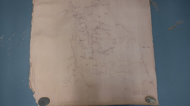
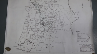
Map - Bogong High Plains
... Map - Bogong High Plains...bogong high plains map...Bogong high Plains showing mountains, places, roads...Bogong High Plains, hand written and 'copied... Centre 31 Bogong High Plains Rd Mt Beauty high-country Bogong ...Bogong high Plains showing mountains, places, roads and riversHistorical changes of infrastructure on the Bogong High PlainsBogong High Plains, hand written and 'copied with considerable simplification from F.C.V. (Falls Creek V.?) 'Feathetop' L 'Tawonga'. Paper is yellowed, writing is brown.bogong high plains map -
 Kiewa Valley Historical Society
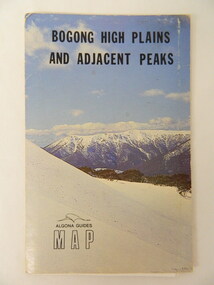
Map - Bogong High Plains & Adjacent Peaks x2, 1976
... Map - Bogong High Plains & Adjacent Peaks x2...bogong high plains. mountains. bushwalkers. walking. map... on the Bogong High Plains. Places, huts and rivers are named and indexed... black and white map of Bogong High Plains and Adjacent Peaks... Centre 31 Bogong High Plains Rd Mt Beauty high-country This map ...This map was produced as a result of the 'pressure from walkers' who are interested in climbing the accessible peaks on the Bogong High Plains. Places, huts and rivers are named and indexed. Contours are not given. Heights of mountains are in metres.The Bogong High Plains is a popular walking area and a National Park. This map identifies the mountains and peaks in the area at the time of publication. Some of the huts have since been destroyed by fire and Mt Niggerhead has since been renamed to Jaithmathang.Blue and white cardboard folded in half containing a folded black and white map of Bogong High Plains and Adjacent Peaks with index.bogong high plains. mountains. bushwalkers. walking. map. national park. recreation. cycling. tourism -
 Kiewa Valley Historical Society
Map - Bogong High Plains - Grazing Runs, Grazing Run Boundaries 1960 - Soil Conservation Authority
... Map - Bogong High Plains - Grazing Runs...bogong high plains...Cattle grazing on the Bogong High Plains during summer...White paper with brown print. Bogong High Plains from... Centre 31 Bogong High Plains Rd Mt Beauty high-country Cattle ...Cattle grazing on the Bogong High Plains during summer commenced in the 1840s and continued for many years. The Soil Conservation Authority recorded each family's area boundaries which were updated in June 1972 and continued to be adjusted until cattle were banned in 2005. The tradition of cattle grazing continues to be controversial.Holders of grazing rights for grazing on the Bogong High Plains were allocated specific areas recorded by the Soil Conservation Authority in 1972. Cattle have been banned in the Alpine National Park due to their impact on the environment.White paper with brown print. Bogong High Plains from Feathertop in the west to Mt Nelse in the east showing physical boundaries including the Kiewa Hydro Electric Scheme, roads, rivers and mountains. Names of families with grazing runs and the boundaries are shown.cattlemen, grazing runs, bogong high plains, kiewa valley families -
 Kiewa Valley Historical Society
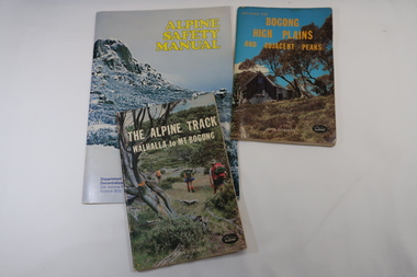
Books x3 - Walking on the Bogong High Plains, 1. The Alpine Track Walhalla to Mt Bogong. 2. Bogong High Plains and Adjacent Peaks both by John Siseman 3. Alpine Safety Manual
... Books x3 - Walking on the Bogong High Plains...1. The Alpine Track Walhalla to Mt Bogong. 2. Bogong High... Centre 31 Bogong High Plains Rd Mt Beauty high-country Books were ...Books were published to guide walkers travelling long distances in remote areas increasing their safety and giving them independence.Bogong High Plains and Mt Bogong are at the upper end of the Kiewa Valley where local people and visitors spend their leisure time, walking.1. and 2. both written by John Siseman, small (pocket size), includes maps and black & white photos. The covers are colored photos with the title at the top. 1. has 78 pages and 2. has 63 pages.The Alpine Safety Manual (in yellow) is twice the size of the others and published by the Department of State Development, Decentralization and Tourism.It has 40 pages, coloured and black & white photos and is held by 2 staples.bush walking, bogong high plais, walhalla to mt bogong, alpine track -
 Falls Creek Historical Society
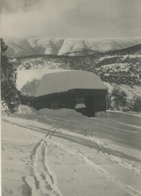
Photograph - Skyline Lodge, Bogong High Plains
... Skyline Lodge, Bogong High Plains...Skyline Lodge, Bogong High Plains.... Skyline Lodge, Bogong High Plains Photograph Skyline Lodge, Bogong ...MEYER COLLECTION - FALLS CREEK PHOTOS In 1947 a determined group of like-minded State Electricity Commission (SEC) staff including Ray Meyer, the chief surveyor of the Kiewa Hydro-Electric Scheme, had a common interest that revolved around the skiing potential of the snow-covered high plains which included what is now the resort of Falls Creek. The six SEC employees, Toni St Elmo, Ray Meyer, Jack Minogue, Lloyd Dunn, Adrian Ruffenacht and Dave Gibson (together with their families) banded together to secretly build a 'hut' that was the first ski lodge at Falls Creek. Using a road built in 1930s to gain access to Falls Creek, their hut project was carried out in secret as efforts by other skiers were blocked by H.H.C. Williams – the engineer in charge of the Hydro Scheme. In 1946 Ray Meyer made a trip to the Lands Office in Melbourne. He came away with a 99-year lease on three acres that was ideally suited for a hut designed by Lloyd Dunn. Adrian Ruffenacht (Design Engineer for the KHS) had suggested where the group should build because of easy access to a spring for water. Much of the building material required was scavenged from derelict huts on the high plains. Due to the need for secrecy, the determined group worked on the hut in the evenings and weekends to avoid detection. During the building period the group had met at Echidna Rock (now known as Eagle Rock) where Skippy St Elmo announced, "This is my favourite ‘Skyline’.” And so the first lodge in the area at Falls Creek Ski Resort came into existence. With the development of the International Poma in the 1970s, the Skyline Lodge, which was sited between the ski-lift’s pole one and pole two, was demolished. However, the legacy of Ray Meyer, Toni St Elmo, Jack Minogue, Lloyd Dunn, Adrian Ruffenacht and Dave Gibson and Skyline lives on in the vibrant atmosphere of Falls Creek Resort. The MEYER COLLECTION documents developments on the Kiewa Hydro Scheme and their life at Falls Creek from the mid 1930s to 1960s.This image is significant because it depicts aspects of the life of a pioneering family of Falls Creek and the founders of "Skyline", the first lodge at Falls Creek.Images of Skyline Lodge. Photo One shows seven feet of snow piled on the roof. This would have been the equivalent of approximately 70 tons in weight being supported by the roof structure.falls creek, victorian snowfields, skyline lodge -
 Falls Creek Historical Society
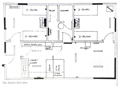
Plan - Floor plan Skyline Lodge, Bogong High Plains
... Floor plan Skyline Lodge, Bogong High Plains...Floor plan Skyline Lodge, Bogong High Plains... in 1955. Floor plan Skyline Lodge, Bogong High Plains Plan Floor ...MEYER COLLECTION - FALLS CREEK PHOTOS In 1947 a determined group of like-minded State Electricity Commission (SEC) staff including Ray Meyer, the chief surveyor of the Kiewa Hydro-Electric Scheme, had a common interest that revolved around the skiing potential of the snow-covered high plains which included what is now the resort of Falls Creek. The six SEC employees, Toni St Elmo, Ray Meyer, Jack Minogue, Lloyd Dunn, Adrian Ruffenacht and Dave Gibson (together with their families) banded together to secretly build a 'hut' that was the first ski lodge at Falls Creek. Using a road built in 1930s to gain access to Falls Creek, their hut project was carried out in secret as efforts by other skiers were blocked by H.H.C. Williams – the engineer in charge of the Hydro Scheme. In 1946 Ray Meyer made a trip to the Lands Office in Melbourne. He came away with a 99-year lease on three acres that was ideally suited for a hut designed by Lloyd Dunn. Adrian Ruffenacht (Design Engineer for the KHS) had suggested where the group should build because of easy access to a spring for water. Much of the building material required was scavenged from derelict huts on the high plains. Due to the need for secrecy, the determined group worked on the hut in the evenings and weekends to avoid detection. During the building period the group had met at Echidna Rock (now known as Eagle Rock) where Skippy St Elmo announced, "This is my favourite ‘Skyline’.” And so the first lodge in the area at Falls Creek Ski Resort came into existence. With the development of the International Poma in the 1970s, the Skyline Lodge, which was sited between the ski-lift’s pole one and pole two, was demolished. However, the legacy of Ray Meyer, Toni St Elmo, Jack Minogue, Lloyd Dunn, Adrian Ruffenacht and Dave Gibson and Skyline lives on in the vibrant atmosphere of Falls Creek Resort. The MEYER COLLECTION documents developments on the Kiewa Hydro Scheme and their life at Falls Creek from the mid 1930s to 1960s.This image is significant because it depicts developments made to "Skyline", the first lodge at Falls Creek.A floor plan of Skyline Lodge, probably after renovations were carried out by the Ski Club of Victoria which bought in to Skyline in 1950. In 1951 - 1952 a road up to the Lodge as well as drains, trenches and culverts were added. renovations to the lounge, basement drainage and porch resurfacing were completed in 1955. falls creek, victorian snowfields, skyline lodge -
 Kiewa Valley Historical Society
Meteorological Conditions - Bogong High Plains
... Meteorological Conditions - Bogong High Plains ...meteorological conditions on the bogong high plains... on the Bogong High Plains including the decades from the 1930s to 1980s... Centre 31 Bogong High Plains Rd Mt Beauty high-country The amount ...The amount of rain and snow during the year and over the years was recorded regularly. This was done at several sites and was important for the building of the Kiewa Hydro Electric Scheme which involved dams, power stations and racelines.The KHES depended on accurate and detailed measurements of rain and snow on the Bogong High Plains in order to plan and construct high functioning infrastructure. Photocopy of pages re the Meteorological conditions on the Bogong High Plains including the decades from the 1930s to 1980s. Snow depths are also documented.kiewa hydro electric scheme, meteorological conditions on the bogong high plains, snow depth on the bogong high plains -
 Kiewa Valley Historical Society
Collection of Papers and Articles - Cattle on the Bogong High Plains
... High Plains...bogong high plains... grazing on the Bogong High Plains. Late 1970s to the late 1980s.... Centre 31 Bogong High Plains Rd Mt Beauty high-country Cattle ...Cattle grazing on the Bogong High Plains was a tradition for the farmers of the Kiewa Valley. Controversy re the environmental impact has recurred over the decades leading to action by the Australian Government.Articles and Papers collection re controversy re cattle grazing on the Bogong High Plains. Late 1970s to the late 1980s.cattlemen, bogong high plains, grazing, kiewa valley beef farmers -
 Kiewa Valley Historical Society
Chart: Bogong High Plains Cattle Allocation
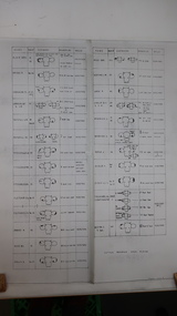
... Chart: Bogong High Plains Cattle Allocation...bogong high plains...Soil Conservation Authority, Bogong High Plains, Cattle... Centre 31 Bogong High Plains Rd Mt Beauty high-country Includes ...Includes the names of farmers in the Kiewa ValleySoil Conservation Authority, Bogong High Plains, Cattle Allocation Marking/Brand Identifications Season 1958/59. Drawn 7-1-59, DWG No 679 file Sc/D/4M Chart gives details of Names, Run No., Earmarks, Brand & Location & Breed of cattle.Penciled in details under 'Name' 1978/Roper/W.Ryder/F.Ryder/W.Hicks/Maddison.chart, cattle, markings, brandings, bogong high plains, roper, ryder, hicks, maddison -
 Kiewa Valley Historical Society
Chart - Cattlemen Families of the Kiewa Valley and their Brands, Cattle Grazing on the Bogong High Plains
... Cattle Grazing on the Bogong High Plains...bogong high plains...Cattle were taken up to the Bogong High Plains... Centre 31 Bogong High Plains Rd Mt Beauty high-country Cattle ...Cattle were taken up to the Bogong High Plains by the Kiewa Valley farmers who had a lease there in their allocated area. The cattle roamed and were mustered in late summer. At this time they also sorted the cattle using the cattle's brands for identification.Types of breeds bred in the Kiewa Valley and the names of families who grazed cattle on the Bogong High Plains is of historical interest and also gives an insight into the history of cattle grazing.White paper, black print. Chart's headings: Name of Family (25 in alphabetical order), Run No., Earmark, Brand and Log and Breed. 29th Feb. 1972 cattle grazing, bogong high plains, kiewa valley families, cattle breeds, cattle brands -
 Kiewa Valley Historical Society
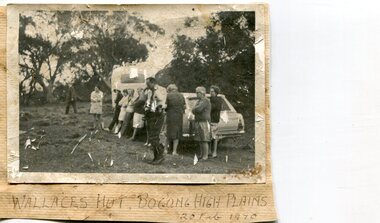
Photographs x 2- Bus tour of Wallaces Hut, 20/02/1970
... Bogong High Plains... Hut, Bogong High Plains, 20 Feb, 1970 2. No markings...Falls Creek, Bogong High Plains, Victoria, Australia... Centre 31 Bogong High Plains Rd Mt Beauty high-country Wallace's ...Wallace's hut was built in 1889 and is probably the oldest surviving hut on the high plains of north-east Victoria. It was built in six weeks by Irish immigrant brothers Arthur, William and Stewart Wallace among old snow gums on a grassy plain above the snowline. The brothers held grazing leases on the High Plains and the hut was built to provide shelter for the cattlemen working there. It is probably the oldest hut on the Victorian high plains. It is part of the early history of hydroelectricity in the state and has links with early SEC meteorological data recording in the area Apart from its historical significance, Wallace’s Hut is a popular stop for tourists and photographers and is the starting point for the Wallace’s Heritage trail, which is a popular and well used hiking track, by locals and visitors alike.2 black and white photographs mounted on buff card. Photos taken during a bus trip to Wallace's Hut on Feb. 20, 1970 1. Group of local Kiewa Valley residents on a bus tour to Wallace's hut 2. Group of adults and children pictured outside Wallace's hut1. Handwritten in black ink on bottom of photo 'Wallace's Hut, Bogong High Plains, 20 Feb, 1970 2. No markingswallace's hut, bogong high plains, bush walking, cattlemen -
 Kiewa Valley Historical Society
Photos - x 29 Falls Creek and Bogong High Plains
... Photos - x 29 Falls Creek and Bogong High Plains...Coloured Falls Creek & Bogong High Plains c 1980s. Includes... Centre 31 Bogong High Plains Rd Mt Beauty high-country Photos ...Photos taken by Alec McCullock circa 1980s. Some of the people include Brian Goss, Bright Shire or Water Board; Graham Cooper, Bright Shire and Paul Goldstone, Bright Shire Surveyor. Appears to be an inspection party comprising Shire, UK Water Board, SECV and other.These men represented the local organisations of the day. Historic changes include the diversity of people who represent organisations today and the actual type of organisations that exist.Coloured Falls Creek & Bogong High Plains c 1980s. Includes SECV People and work s.e.c.v. 1980s, bright shire 1980s