Showing 99 items matching "breakwater pier"
-
 Flagstaff Hill Maritime Museum and Village
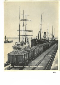
Photograph - Vessels at Breakwater Pier, Warrnambool, Foyle Photographic Studio, circa 1906
... Vessels at Breakwater Pier, Warrnambool...A black and white photograph titled "Breakwater Pier, Warrnambool". A line of coal trucks on rails are on the Breakwater. ...Front of photograph - "BREAKWATER PIER, WARRNAMBOOL." "FOYLE PHOTO" Back of photograph - "Sailing Ship" "Speculant sail ship" "Barrabool coal ship" "Flinders Passenger ship" Name of donor W'Bool (and telephone number) "K-7148 M" (stamped upside down)...Photograph Vessels at Breakwater Pier, Warrnambool Foyle Photographic Studio ...This photograph was one of ten photographs donated to Flagstaff Hill Maritime Museum and Village by Fred Trewartha. Frederick John Fox Trewartha (Fred) was a well-known Warrnambool businessman. He was born in Beeac near Geelong in 1920 and came to Warrnambool with his family as a very young child. He was apprenticed to his father John, as a saddler and later opened his own shop on Raglan Parade. He then moved into working with tarpaulins and canvases for the trucking industry. Fred was keenly interested in photography (and was a member of the Warrnambool Cine Club), yachting and boat building. He kept his yacht moored at Port Fairy for many years and participated in sailing events locally and interstate. He also built boats with his sons. He had the opportunity to meet many older sailors and it's thought this photo (and others in the set) may have been given to him by one of these men. Fred Trewartha died in 2016 in Warrnambool. The three identifiable ships in this picture are the "Speculant", the "S. S. Barrabool" and the "S. S. Flinders" - coastal trading vessels that regularly came and went from Warrnambool. The steamer on the left hasn't been identified. The barquentine SPECULANT was a steel, three-masted sailing ship built in 1895 in Inverkeithing, Scotland, registered in Warrnambool, Victoria and wrecked at Cape Paton, Victoria, 10th February 1911. The SPECULANT had been involved in the timber trade between the United Kingdom and Russia, until sold to its Warrnambool owners and timber merchants Messrs. P.J. McGennan & Co. (Peter John McGennan) in 1902 for 3000 pounds and had her sailed to Warrnambool as her new port. Peter John McGennan was born in 1844 and worked as a builder and cooper in Holyhead, Anglesea, Wales. He immigrated to Australia in 1869 as a free settler and arrived in Warrnambool in 1871 and undertook management of a property in Grassmere for Mr. Palmer. Peter met his wife Emily in South Melbourne and they married in 1873. They had ten children including Harry who lived to 1965, and Andrew who lived until 1958. (The other children were their four brothers - John who was killed in the Dardenalles aged 35, Frederick who died aged 8, Peter who died aged 28, Frank who died aged 5 weeks - and four sisters - Beatrice who died age 89, Edith who died aged 49, Blanche who died aged 89 and Eveline who died aged 48.) In 1874 Peter starting a boating establishment on the Hopkins River. In 1875 he opened up a Coopers business in Kepler Street next to what was Bateman, Smith and Co., moving to Liebig Street, next to the Victoria Hotel, in 1877. In 1882 he then moved to Lava Street (which in later years was the site of Chandlers Hardware Store). He was associated with the establishment of the Butter Factory at Allansford. He started making Butter Boxes to his own design and cheese batts for the Butter Factory. In 1896 established a Box Factory in Davis Street Merrivale, employing 24 people at its peak, (it was burnt down in 1923); and in Pertobe Road from 1912 (now the Army Barracks building). Peter was a Borough Councillor for Albert Ward from 1885 to 1891, he commenced the Foreshore Trust (including the camping grounds along Pertobe Road), and he was an inaugural Director of the Woollen Mill in Harris Street, buying an extensive share-holding in 1908 from the share trader Edward Vidler. They lobbied the Town Hall to have a formal ‘Cutting’ for the waters of the Merri River to be redirected from its natural opening south of Dennington, to its existing opening near Viaduct Road, in order to have the scourings from the wool at the Woollen Mill discharged into the sea. He sold Butter Boxes around the state, and had to ship them to Melbourne by rail. Peter’s purchase of the SPECULANT in 1902 enabled him to back-load white pine from Kaipara, New Zealand to Warrnambool to make his butter boxes then, to gain profitability, buy and ship potatoes and other primary produce bound to Melbourne. (McGennan & Co. had also owned the LA BELLA, which had traded in timber as well, until she was tragically wrecked with the loss of seven lives, after missing the entrance channel to Warrnambool harbour in 1905. It appears that the SPECULANT was bought to replace the LA BELLA.) In 1911 the SPECULANT had been attempting to depart Warrnambool for almost the entire month of January to undergo docking and overhaul in Melbourne. A month of east and south-easterly winds had forced her to remain sheltered in Lady Bay, Warrnambool apart from one morning of northerlies, when an attempt was made to round Cape Otway; she had to return to shelter in Portland after failing to make any headway. With only 140 tons of sand ballast aboard, the ship would not have been easy to handle. Captain Jacobsen and his crew of nine, mainly Swedes, decided to make for Melbourne, leaving Portland Harbour on 5th February 1911. By the 9th they had reached Cape Otway, where they encountered a moonless night, constant heavy rain, and a heavy sea with a south-easterly wind blowing. After safely rounding Cape Otway the course was changed to east, then north-east to take the vessel to a point six miles off Cape Patton, following the orders of Captain Jacobsen, who told the crew to be very careful with the steering, as the wind and sea was running to leeward. The patent log (used to measure speed) had been out of order for the last four months as no-one in Warrnambool was able to fix it: it was intended to have it repaired in Melbourne. In the meantime the crew measured the vessel's speed by looking over the side and estimating wind strength. This compounded the difficulties of imprecise positioning, as the strong cross wind and sea were acting on the lightly laden vessel to steadily drive it towards the shore. At 3.30am on Friday 10 February 1911 Captain Jacobsen and the first mate were looking over the side of the vessel when they heard the sound of breakers and suddenly struck the rocks. The crew immediately knew they had no chance of getting the SPECULANT off, and attempted to rescue themselves by launching the lifeboat, which was instantly smashed to pieces. One of the crew then volunteered to take a line ashore, and the rest of the crew were all able to drag themselves to shore, some suffering hand lacerations from the rocks. Once ashore they began to walk along the coast towards Lorne, believing it was the nearest settlement. Realising their mistake as dawn broke they returned westwards to Cape Patton, and found a farm belonging to Mr C. Ramsden, who took them in and gave them a change of clothes and food. After resting for a day and returning to the wreck to salvage some of their personal possessions, at 10am on Saturday they set out for Apollo Bay, a voyage that took six hours, sometimes wading through flooded creeks up to their necks. The Age described the wreck as "listed to starboard. All the cabin is gutted and the ballast gone. There is a big rock right through the bottom of her, and there is not the slightest hope of getting her off". A Board of Marine inquiry found that Captain Jacobson was guilty of careless navigation by not taking steps to accurately verify the position of the vessel with respect to Cape Otway when the light was visible and by not setting a safe and proper course with respect to the wind and sea. It suspended his certificate for 6 months and ordered him to pay costs. The location of the wreck site was marked for a long time by two anchors on the shoreline, until in 1970 the larger of the two anchors was recovered by the Underwater Explorers' Club and mounted on the foreshore at Apollo Bay. The bell from the wreck was also donated to the Apollo Bay Surf Lifesaving Club but is recorded to have been stolen. Rusting remains of the wreck can still be found on the shoreline on the southern side of, and directly below Cape Patton. Parts of the SPECULANT site have been buried by rubble from construction and maintenance works to the Great Ocean Road, as well as by naturally occurring landslides. Peter J McGennan passed away in 1920. The Gates in the western wall of the Anglican Church in Henna Street/Koroit St are dedicated to him for his time of community work, which is matched with other prominent Warrnambool citizens; Fletcher Jones, John Younger, J.D.E (Tag) Walter, and Edward Vidler. After Peter J McGennan's death Harry, Andrew and Edith continued to operate the family business until July 11th 1923 when the company was wound up. (Andrew lived in Ryot Street Warrnambool, near Lava Street.) Harry McGennan (Peter and Emily’s son) owned the Criterion Hotel in Kepler Street Warrnambool (now demolished). His son Sid and wife Dot lived in 28 Howard Street (corner of Nelson Street) and Sid managed the Criterion until it was decided by the family to sell, and for he remained Manager for the new owners until he retired. Harry commenced the Foreshore Trust in Warrnambool around 1950. The McGennan Carpark in Pertobe Road is named after Harry and there are Memorial-Stone Gates in his memory. (The Gates were once the original entrance to the carpark but are now the exit.). The Patent Log (also called a Taffrail log) from the SPECULANT, mentioned above, and a number of photographs, are now part of the Collection at Flagstaff Hill Maritime Village.. The S. S. Flinders was built by A. J. Inglis, Ltd, Pointhouse, Glasgow in 1878 for the "Tasmanian Steam Navigation Company', Hobart which merged with the "Union Steamship Company" of New Zealand and it was later sold to the firm "McIlwraith, McEacham and Company". It was built of iron and was 1000 tons and 227 feet, 1 inch long. It was described as "splendidly fitted up for the carriage of passengers and her cargo space was also very large". In the saloon about 130 passengers could be accommodated while the second class had sufficient room for one hundred passengers. In 1890, the S. S. Flinders would leave Melbourne on Mondays and Thursdays at 5 pm and reach Warrnambool the following morning at 8 am. On the return it would leave Warrnambool on Wednesdays and Saturdays at 5 pm and reach Melbourne the following morning. In 1896, the Weekly Times described the "steamer Flinders (otherwise known as "the Warrnambool mailboat") as "as good a sample of a seagoing steamer as there is trading on the Victorian Coast at the present time". In April 1896 newspaper reports noted the S. S. Flinders took 2915 bags of potatoes from Warrnambool to Melbourne (the largest shipment of that season) as well as 50 tons of tinned rabbits from the Hamilton Preserving Factory. It was also noted that particularly during the Christmas period, there were excessive demands for berths from holiday makers wanting to enjoy a holiday in Warrnambool. In May 1903, the S. S. Flinders narrowly escaped destruction when an explosion and subsequent fire occurred during the passage from Melbourne to Warrnambool. A drum (which apparently contained carbide of calcium) exploded and blew off a hatch cover. As the steamer got to within a mile or two of Warrnambool, smoke was seen coming out of the hold and (unknown to the passengers) flames had taken hold. The crew quickly got to work - closing down all the hatches and pumping water into the hold through a hole in the saloon floor. There were 30 or 40 cases of kerosene on board. The Flinders continued on to Warrnambool and berthed at the Breakwater. The passengers all went ashore - many unaware of the danger they had been in. A telephone message was sent to the local Fire Brigade Station however the fire was extinguished before the firemen and their equipment arrived. After the hold was checked, the Flinders was certified as seaworthy and left for Portland. The Flinders continued to transport Western District produce as well as passengers from Warrnambool to Melbourne until 1906 when (due to a decrease in shipping trade during the Winter and the availability of train services) the Flinders was replaced by the smaller steamer "Dawn" and in 1907 when it was sold to the "Adelaide Steamship Company" for use in the Western Australia coastal trade, it was replaced by the "S. S. Barrabool". The S. S. Barrabool was a coastal steamer built by "Palmer Shipbuilding and Iron Company Limited" in Jarrow, Durham in 1874. It was bought by "Howard Smith Ltd" who was a pioneer in the coal trade between Melbourne and Newcastle. Howards Smith's early fleet contained ships named after local hills and mountains -"You Yangs", "Macedon", "Dandenongs" and "Barrabool". Later they extended their fleet to include ships that were well known in Warrnambool including the "Dawn" and the "Edina". The S. S. Barrabool had a chequered start and was nicknamed the "Great Australian Ram" because of the numerous accidents it was involved in. Between 1875 and 1883 it collided with three other vessels - sinking the "Queensland" on August 3rd, 1876, near Wilson's Promontory and sinking the "Bonnie Dundee" on 10th March 1879 off Lake Macquarie, New South Wales (with the loss of five lives). In August 1884 the Barrabool collided with the steamer "Birksgate" in Port Jackson causing considerable damage to "Birksgate". However in a newspaper article published in the "Truth" in March 1899 the S. S. Barrabool was described as "one of the fine old type of vessels" and "still a stout a craft as ever". The article was describing the practice of a "two-mate" system on board many ships (the Barrabool being one) whereby the company only employs two men (a first and second mate who must alternate watches of four hours each) rather than three mates who work four hours on and eight hours off. It was suggested that ships employing the "two-mate" system may find their insurance policies "null and void" should an accident occur. However the writer did note that the Barrabool was "officered by a captain and first and second mates .. whom it would be impossible to find more capable officers amongst the maritime fleet of the colonies". Between 1900 and 1909 the Barrabool was making regular trips along the east coast of Australia, carrying coal to Hobsons Bay (Melbourne) from Newcastle, Bellambi and Sydney. In 1907 it was brought in as a temporary replacement on the Melbourne to Warrnambool route for the S.S. Flinders. In 1912 the S. S. Barrabool ran aground off the Fitzroy River in Queensland and was found to be uneconomic to repair. It was brought back to Sydney and converted into a hulk. In August 1952 it was towed 17 miles off Sydney and scuttled. “Foyle” written on the photograph is the name of Foyle’s Photographic studio - originally owned by James Charles Foyle. He owned “Foyle’s Photo Card Studios” in Liebig St, Warrnambool, which operated between 1889 – 1919 At the time of the photograph the studio was owned by both Charles and Lilian Foyle (sometimes known as Lillian or Lily), either of whom could have taken this photograph. They also worked together at a later date on the photographs, sketches and paintings of the famous and historical Pioneers’ Honour Board.This photograph is a significant record of three of the well-known coastal traders (the "Speculant", the "S. S. Barrabool" and the "S. S. Flinders") that sailed along the southwest coast of Victoria for many years - transporting goods and passengers between Melbourne and Warrnambool.A black and white photograph titled "Breakwater Pier, Warrnambool". A line of coal trucks on rails are on the Breakwater. There are three ships (one sailing ship and two steamers) moored at the pier. In the left side of the picture is another ship. The name of the photographer is printed in the lower right corner. On the back of the photograph are the handwritten names of the moored ships written in blue pen. It also has the handwritten name, town and telephone number of the donor. In the bottom right hand corner is an upside down stamped number in black ink.Front of photograph - "BREAKWATER PIER, WARRNAMBOOL." "FOYLE PHOTO" Back of photograph - "Sailing Ship" "Speculant sail ship" "Barrabool coal ship" "Flinders Passenger ship" Name of donor W'Bool (and telephone number) "K-7148 M" (stamped upside down)flagstaff hill maritime museum and village, warrnambool, great ocean road, shipwreck coast, speculant, barque speculant, p. j. mcgennan, peter john mcgennan, speculant wreck, captain jacobsen, s. s. flinders, steamer flinders, a. j. inglis ltd, tasmanian steam navigation company, mcilwraith mceacham and company, warrnambool mailboat, coastal steamer, s. s. barrabool, howard smith ltd, two-mate system, coal ship, dawn, edina, lady bay, breakwater, warrnambool breakwater, foyle, foyle photographic studio warrnambool -
 Williamstown Historical Society Inc
Postcard - Alice Evans Postcard Collection, 1905-1909
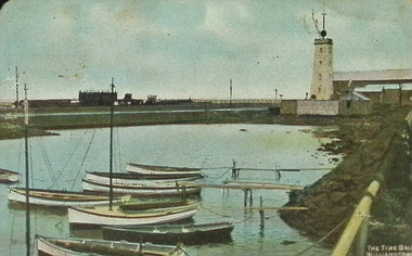
... ...Breakwater Pier...This card depicts the boat harbour with boats, between Railway and Breakwater Piers, with the Timeball Tower (painted white) in Williamstown, in the background....Timeball Tower Breakwater Pier Railway Pier Williamstown Alice Evans Postcards Part of a collection of 142 Postcards. ..."Dear Alice" Is a collection of 142 Postcards from Australia and around world, almost all of which are addressed to Miss Alice Evans, No. 2 Cox Gardens, Williamstown, dated between 1905 - 1909. These postcards form part of a collection found in the ceiling of No. 2 Cox Gardens by a local builder and carpenter Gordon Peterson. Peterson was contracted to demolish the house in the mid 1970's. The cards were held in the Estate of Gordon Peterson, along with a photo of the cottage, before demolition until donation to the historical society by his descendants in 2024. Alice Edith Evans was born in Williamstown in 1885 to parents Benjamin Samuel Evans (1833-1900), a bootmaker from Ruabon, Denbighshire, Wales and Catherine (nee Jones) (1850-1915) from Eaglehawk, near Castlemaine. Alice had three older step sisters, and two younger brothers, Benjamin and Samuel, who sadly died in infancy. Alice’s father, Benjamin, had been married previously, his wife dying during childbirth, leaving him with three daughters to care for. After leaving school, Alice was employed as a clerk with Trevor Jones & Co. (real estate agents), until her declining health prevented her from working. She was an active and well known member of the Welsh Church and Sunday School on Ferguson Street and enjoyed singing and playing in local concerts. Well known in the community, a Grand Benefit Concert was organised in her honour on 9th April, 1910, at the Mechanics Institute, Williamstown. Hosted by Mayor Cr. Wymark, the event featured a delightful program of musical performances, showcasing both individual talents and the Carlton Club Choir. Tragically, Alice passed away due to the effects of her illness on 3rd December 1910, at the age of just 25. She is buried in Williamstown Cemetery. The postcards, written between 1905 to 1906, illustrate the social history of residents and everyday life at the turn of the century, using postcards as a means of communication.Part of a collection of 142 Postcards. This card depicts the boat harbour with boats, between Railway and Breakwater Piers, with the Timeball Tower (painted white) in Williamstown, in the background.timeball tower, breakwater pier, railway pier, williamstown, alice evans postcards -
 Flagstaff Hill Maritime Museum and Village
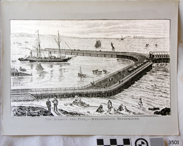
Artwork, other - Lithograph, The Viaduct and Pier - Warrnambool Breakwater
... The Viaduct and Pier - Warrnambool Breakwater...pier...warrnambool breakwater...Titled "The Viaduct and Pier - Warrnambool Breakwater". ...Flagstaff Hill Maritime Museum and Village 89 Merri Street Warrnambool great-ocean-road flagstaff hill warrnambool shipwrecked-coast flagstaff-hill flagstaff-hill-maritime-museum maritime-museum shipwreck-coast flagstaff-hill-maritime-village lithograph viaduct and pier warrnambool breakwater Titled "The Viaduct and Pier - Warrnambool Breakwater". ...Titled "The Viaduct and Pier - Warrnambool Breakwater". flagstaff hill, warrnambool, shipwrecked-coast, flagstaff-hill, flagstaff-hill-maritime-museum, maritime-museum, shipwreck-coast, flagstaff-hill-maritime-village, lithograph, viaduct and pier, warrnambool breakwater -
 Port Melbourne Historical & Preservation Society
Photograph - Consrtuction of restaurants on the breakwater at Station Pier, Port Melbourne, 2000 - 2001
... Consrtuction of restaurants on the breakwater at Station Pier, Port Melbourne...(6) colour photographs showing the construction of three restaurants on the breakwater near Station Pier...Port Melbourne Historical & Preservation Society Port Melbourne Town Hall 333 Bay Street Port Melbourne melbourne Further updates of Port Melbourne taken by Ron Laing (2000/1) and donated to the Society built environment - commercial piers and wharves - station pier smallpage family (6) colour photographs showing the construction of three restaurants on the breakwater near Station Pier Photograph Consrtuction of restaurants on the breakwater at Station Pier, Port Melbourne ...Further updates of Port Melbourne taken by Ron Laing (2000/1) and donated to the Society(6) colour photographs showing the construction of three restaurants on the breakwater near Station Pierbuilt environment - commercial, piers and wharves - station pier, smallpage family -
 Lakes Entrance Historical Society
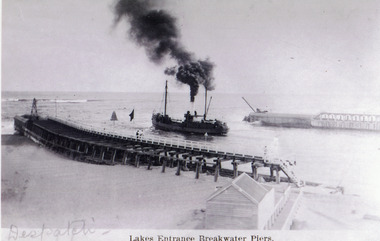
Photograph - SS Despatch, c1910
... Lakes Entrance Breakwater Piers...Lakes Entrance Historical Society 4 Marine Parade Lakes Entrance gippsland Waterways Jetties Ships and Shipping Lakes Entrance Breakwater Piers Black and white photograph showing SS Despatch steaming out the Entrance. ...Black and white photograph showing SS Despatch steaming out the Entrance. Photo shows wooden piers with concrete extensions, kiosk beside boardwalk and black smoke from funnel of ship. Lakes Entrance VictoriaLakes Entrance Breakwater Piers waterways, jetties, ships and shipping -
Glenelg Shire Council Cultural Collection
Photograph - Photograph - Main Breakwater construction, Portland, n.d
... Breakwater... ocean pier...Black and white aerial photo of the harbour, showing early stage Lee Breakwater, Ocean Pier, with ship berthed, Railway Pier, Fishermen's Breakwater. ...Glenelg Shire Council Cultural Collection History House Cliff Street Portland great-ocean-road Port of Portland Authority Archives Port of Portland Archives harbour construction main breakwater Fishermans Breakwater ocean pier Front: 'c'- Pink texta Back: 'c' - Pink texta Black and white aerial photo of the harbour, showing early stage Lee Breakwater, Ocean Pier, with ship berthed, Railway Pier, Fishermen's Breakwater. ...Port of Portland Authority ArchivesFront: 'c'- Pink texta Back: 'c' - Pink textaport of portland archives, harbour construction, main breakwater, fishermans breakwater, ocean pier -
Glenelg Shire Council Cultural Collection
Photograph - Photograph - Portland Harbour, n.d
... Breakwater... Ocean Pier...Black and white photograph showing construction of S.L Paterson Wharf (Lee Breakwater). Ocean Pier & K.S. Anderson Wharf in background, both with ships berthed at them....Glenelg Shire Council Cultural Collection History House Cliff Street Portland great-ocean-road Port of Portland Authority Port of Portland Archives Portland Harbour SL Paterson Wharf Construction Lee Breakwater Ocean Pier K S Anderson Wharf Black and white photograph showing construction of S.L Paterson Wharf (Lee Breakwater). ...Port of Portland Authorityport of portland archives, portland harbour, sl paterson wharf construction, lee breakwater, ocean pier, k s anderson wharf -
Glenelg Shire Council Cultural Collection
Photograph - Photograph - Portland Harbour, n.d
... Breakwater... Ocean Pier...Black and white aerial photo showing part of K.S Anderson Wharf, Silos, S.L Patterson (Lee Breakwater) Wharf, Ocean Pier partly demolished....Glenelg Shire Council Cultural Collection History House Cliff Street Portland great-ocean-road Port of Portland Authority Archives Port of Portland Archives K S Anderson Wharf Silos Lee Breakwater Ocean Pier Back: harb016 - pencil Black and white aerial photo showing part of K.S Anderson Wharf, Silos, S.L Patterson (Lee Breakwater) Wharf, Ocean Pier partly demolished. ...Port of Portland Authority ArchivesBack: harb016 - pencilport of portland archives, k s anderson wharf, silos, lee breakwater, ocean pier -
Glenelg Shire Council Cultural Collection
Photograph - Photograph - Portland Harbour, n.d
... Pier... Fishermans Breakwater...Ocean Pier, Railway Pier & Fishermen's Breakwater, can be seen....Glenelg Shire Council Cultural Collection History House Cliff Street Portland great-ocean-road Port of Portland Authority Archives Port of Portland Archives Portland Harbour Railway Pier Fishermans Breakwater Ocean Pier Black & white photo of Portland harbour, looking south. ...Port of Portland Authority Archivesport of portland archives, portland harbour, railway pier, fishermans breakwater, ocean pier -
Glenelg Shire Council Cultural Collection
Photograph - Photograph - Lee Breakwater, Portland, n.d
... Breakwater... Ocean Pier...Lee Breakwater under construction can be seen, also Baths, Ocean Pier, Railway Pier & Fishermens Breakwater....Lee Breakwater under construction can be seen, also Baths, Ocean Pier, Railway Pier & Fishermens Breakwater. ...Port of Portland Authority Archivesport of portland archives, portland harbour, lee breakwater, ocean pier, railway pier, construction -
 Glenelg Shire Council Cultural Collection
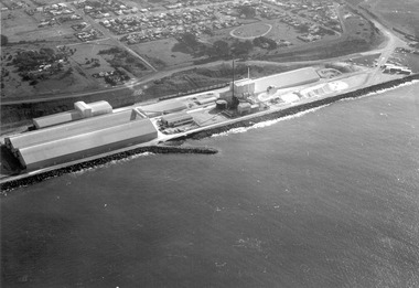
Photograph - Photograph - Cresco/Pivot, c. 1960
... Black and white photograph of a factory at the edge of a large body of water with man-made breakwater/pier....Glenelg Shire Council Cultural Collection History House Cliff Street Portland great-ocean-road Port of Portland Authority archives Port of Portland Front: (no inscriptions) Back: (no inscriptions) Black and white photograph of a factory at the edge of a large body of water with man-made breakwater/pier. Photograph Photograph - Cresco/Pivot ...Port of Portland Authority archivesFront: (no inscriptions) Back: (no inscriptions)port of portland -
Glenelg Shire Council Cultural Collection
Photograph - Photograph - Lee Breakwater, Portland, n.d
... Breakwater... Ocean Pier...Black & white photo of Portland Harbour Lee Breakwater under construction, front. Also Ocean Pier, Railway Pier, Fisherman's Breakwater and part of the K. ...Glenelg Shire Council Cultural Collection History House Cliff Street Portland great-ocean-road Port of Portland Authority Archives Port of Portland Archives Lee Breakwater Ocean Pier Railway Pier harbour Portland Black & white photo of Portland Harbour Lee Breakwater under construction, front. ...Port of Portland Authority Archivesport of portland archives, lee breakwater, ocean pier, railway pier, harbour, portland -
 Flagstaff Hill Maritime Museum and Village
Postcard - Postcard Folder, scenes, Valentine & Sons Co. Publishing Ltd, Warrnambool Photographic Souvenir, Early-to-mod 20th century
... ...The Breakwater and Pier...The Road to Sandy Beach . The Breakwater and Pier ...The Road to Sandy Beach . The Breakwater and Pier This Valentine postcard folder was produced in Australia. ...This postcard folder is one of three in a set of postcards that were published in Victoria, Australia, and collected together. The Valentine Publishing Co. Pty. Ltd. produced this folder. Valentine and Sons was a printing and photography business based in Dundee, Scotland, and in Canada. In the early 1900s, at the height of the postcard craze, the firm published large numbers of postcards in the U.K., Canada, U.S., Australia and South Africa. From around 1900 or earlier, the firm bought many lithographic images for its postcards from local and national photographers who sold publishing rights to Valentines, and the business was famous for publishing photographs of popular sites worldwide. Postcard titles in this folder include many of those in the Rose postcard folders plus the following titles that are not duplicated. . Municipal Buildings and Post Office . Soldiers’ Memorial . Hopkins River . The Cliffs at Shelly Beach . The Road to Sandy Beach . The Breakwater and Pier This Valentine postcard folder was produced in Australia. It includes pictures from the early-to-mid 20th century. It is one of three in a set, with images of the same locations as other images in our collection but at different periods in time. Each postcard records a moment in history and is significant as a way to compare and show the changes in the local environment and community, building a story of the local history. The images record changes in the coastline, land, bay, buildings and other structures, roads, transportation and even the fashions of the times.Postcard folder, Valentine Publishing, cream cover. One of a set of three displaying images of Warrnambool and district around the mid-20th century. Print on the front and back covers is in brown ink. The front has an image of two laughing kookaburras on a branch, three address lines and an outline for a postage stamp. The back cover has the publisher’s details and a line for a return address. The cover opens like a book, and then the double-sided, Z-folded page of photographs drops downward. Titles are printed below each of the fifteen black and white photographs inside. The folder is secured on the back cover by placing a tab into a slot. The folder was produced by The Valentine Publishing Co. Pty. Ltd. Melbourne“WARRNAMBOOL / PHOTOGRAPHIC SOUVENIR” Symbol: [Two facing kookaburras standing on a branch with beaks open] “Published by The Valentine Publishing Co. Pty. Ltd. Melbourne” flagstaff hill maritime museum and village, great ocean road, shipwreck coast, warrnambool, flagstaff hill, flagstaff hill maritime museum, flagstaff hill maritime village, warramble, postcard, postcard folder, warrnambool scenes, picturesque views of warrnambool, picturesque views of warramble, lady bay, port of warrnambool, breakwater, warrnambool breakwater, viaduct, merri river footbridge, merri river suspension bridge, suspension footbridge, merri river mouth, hopkins river mouth, proudfoot's, fanny nelson, nelson's boatsheds, nelson's boathouse, boathouse, hopkins river boathouses, flett's boathouse, flett, george rose, image of a rose, rose series, rose stereograph co, rose stereographic company, lighograph, armadale victoria, lady bay beach, beach scene, lower light, concrete footbridge, 1922 footbridge, viaduct road, rose postcard, new concrete bridge, 1945, 1890, 1922, small footbridge, 1872 footbridge, 1872, merri river estuary, stingray bay, postcards, concertina fold, z fold, shipwrecked coast, maritime museum, souvenir, warrnambool local scenes, photography, local history, tourism, photographs, visitors, travel, scenes, mid-20th century, 1940s, 1950s, z-fold, 1880s, collection, correspondence, valentine publishing co. pty. ltd melbourne, valentine publishing co. pty. ltd sydney, municipal buildings and post office, soldiers’ memorial, hopkins river, the cliffs at shelly beach, the road to sandy beach, the breakwater and pier -
Glenelg Shire Council Cultural Collection
Photograph - Photograph - Lee Breakwater, Portland, n.d
... Breakwater... construction... Ocean Pier...Black & white photo showing : Lee Breakwater under construction; Ocean Pier; K.S. Anderson; Battery point; Lawrence Rocks...Glenelg Shire Council Cultural Collection History House Cliff Street Portland great-ocean-road Port of Portland Authority Archives Port of Portland Archives Lee Breakwater construction Ocean Pier Battery Point K S Anderson Wharf Black & white photo showing : Lee Breakwater under construction; Ocean Pier; K.S. ...Port of Portland Authority Archivesport of portland archives, lee breakwater, construction, ocean pier, battery point, k s anderson wharf -
Glenelg Shire Council Cultural Collection
Print - Contact Print - Portland Harbour, 1960-1970
... Breakwater... Railway Pier...Fishermans Breakwater on right. Railway Pier and Ocean Pier on left. ...Glenelg Shire Council Cultural Collection History House Cliff Street Portland great-ocean-road Portland Harbour Fishermans Breakwater Railway Pier Ocean Pier Black and white contact print. ...Black and white contact print. Image shows Portland Harbour, from Town Hall. Fishermans Breakwater on right. Railway Pier and Ocean Pier on left. Two Steamers in bay and fishing fleet at anchor off Henty Beach. Foundations for 2nd Baths at Henty Beach.portland harbour, fishermans breakwater, railway pier, ocean pier -
Glenelg Shire Council Cultural Collection
Photograph - Photograph - Early Shipping: Ocean/Railway Pier, n.d
... Breakwater... Ocean Pier...Lee Breakwater under construction in foreground, then Ocean Pier with one ship at berth, K.S Anderson under construction in background....Glenelg Shire Council Cultural Collection History House Cliff Street Portland great-ocean-road Port of Portland Authority Archives Port of Portland Archives Portland Harbour Lee Breakwater Ocean Pier KS Anderson Construction Black and white photo, taken from clifftop, looking across harbour. ...Port of Portland Authority Archivesport of portland archives, portland harbour, lee breakwater, ocean pier, ks anderson construction -
Glenelg Shire Council Cultural Collection
Photograph - Photograph - Lee Breakwater, Portland, n.d
... Breakwater... Ocean Pier...Glenelg Shire Council Cultural Collection History House Cliff Street Portland great-ocean-road Port of Portland Authority Archives Port of Portland Archives tanker berth Lee Breakwater Ocean Pier Portland Harbour Back: Purple stamp - Portland "Guardian" Piece of paper attached - typed 7. ...Port of Portland Authority ArchivesBack: Purple stamp - Portland "Guardian" Piece of paper attached - typed 7. New oil berth at Portlandport of portland archives, tanker berth, lee breakwater, ocean pier, portland harbour -
Glenelg Shire Council Cultural Collection
Photograph - Photograph - Lee Breakwater, Portland, n.d
... Breakwater... Ocean Pier...Lee Breakwater under construction in foreground. Ship berthed at Ocean Pier middle, ship berthed at K. ...Glenelg Shire Council Cultural Collection History House Cliff Street Portland great-ocean-road Port of Portland Authority Archives Port of Portland Archives Lee Breakwater Ocean Pier K S Anderson Wharf Front: General View of Portland Harbour Lee Breakwater in foreground --pencil 6970 - pencil. ...Port of Portland Authority ArchivesFront: General View of Portland Harbour Lee Breakwater in foreground --pencil 6970 - pencil. New Oil Tanker Berth (black biro) Photo - B < 3 1/8 "wide - blue "HIGHLIGHTS OF THE YEAR" - blue biro 120#port of portland archives, lee breakwater, ocean pier, k s anderson wharf -
 Flagstaff Hill Maritime Museum and Village
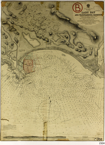
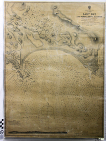
Document - Navigation Chart, Admiralty Office, Lady Bay and Warrnambool Harbour, 1893
... ...Breakwater...Jetty...Pier...Flagstaff Hill Warrnambool Flagstaff Hill Maritime Museum & Village Maritime Museum Maritime Village shipwreck coast Map chart Navigation chart plan Lady Bay Warrnambool Harbour Port of Warrnambool Breakwater Jetty Pier Dock extension proposed extension VHR H2024 1870 1893 1910 1925 Warrnambool town late 1800s Warrnambool streets late 1800s Royal Commission 1923 Public Works Water Commission Harbour Trust Victorian Harbours Sir Jon Coode Stamp, rectangular, including "AUG 1910" Stamp, double oval " - - - -CHART" Stamp, hand drawn, red circle, with "B" inside Hand written note "22-8-1910 - - - - - of surveying C. ...This navigation cart of Lady Bay and Warrnambool Harbour was originally surveyed in 1870 but this version includes the update for magnetic variation in 1893. Since the printing of the chart several annotations have been added. These include an additional stamp dated 15-8-1910, a handwritten comment across the top of the page dated August 1910, and another handwritten comment regarding the ‘Proposed Extension of Dock’ dated 19-2-1925, plus connected drawings, notes and figures. The 1925 proposal on this chart may have been a reaction to the Royal Commission of 1923, when the damaged stonework on the seaward side of the Warrnambool Breakwater, caused by the action of the sea, was the subject of enquiry. A conference between the Public Works, Water Commission and the Harbour Trust concluded that it would less costly to make repairs to prevent further damage rather than replaced the damage portion of the wall. A contract was raised in late 1924 to deposit rubble on the damaged side of the breakwater to minimise the Southern Ocean’s destructive action and work had started by August 1925. The Breakwater construction had begun in 1874 and was completed in 1890. The Victorian Government had commissioned Sir John Coode, a British harbour engineer, to present a plan to complete the Warrnambool Breakwater but his original plan was too expensive. He prepared a revised plan for a shorter structure. The construction proved to be too short to protect adequately from the weather and didn't allow enough depth for larger vessels to come into port. The decreasing trade was further affected by siltation in the bay due to the breakwater, and the completion of the railway line. The situation of the harbour became a real problem by 1910 and required continuous dredging. In 1914 the Breakwater was extended but proved to be a failure because the work began to subside and by 1920 about two thirds of the harbour was silted up. Alterations made in the 1920's increased the silting problem and by the 1940's the harbour was no longer used. More alterations were made in the 1950's and 1960's. This chart is significant for its strong connection to the maritime history of Warrnambool Harbour and Lady Bay and the Warrnambool Breakwater. The Warrnambool Breakwater is registered as a place of significance on the Victorian Heritage Database (VHR H2024). The Warrnambool Breakwater is one of the most important late 19th century maritime engineering projects in Victoria and significant in the development of Victorian coastal shipping. It is also significant for its connection with British harbour engineer, Sir John Coode. The chart is a historical record of structures existing in 1893; the Warrnambool Jetties, Warrnambool Breakwater in Lady Bay, the leading lights (lighthouses), streets, roads, bridges and many buildings. It also shows the lay of the land and seabed. Navigation Chart: Lady Bay and Warrnambool Harbour, Australia - South Coast - Victoria. Surveyed by Nav. Lieut. H.J. Stanley, R.N., 1870. Updated for Magnetic Variation, 1893. The rectangular chart is printed on heavy cream paper. Stamps are shaped rectangular, oval and round. Around the Breakwater and Jetty area are handwritten notes, dotted and joined lines, numbers and signatures, and shading of red and green. The chart shows the surrounds of Warrnambool Harbour, Lady Bay, the Breakwater and Jetty, roads, bridges and the streets in Warrnambool. It has sounding details, and angles of line from the leading lights.Stamp, rectangular, including "AUG 1910" Stamp, double oval " - - - -CHART" Stamp, hand drawn, red circle, with "B" inside Hand written note "22-8-1910 - - - - - of surveying C. Ca - - - request of 15-8-10 [initials] " Notes and lines in red pen, including a grid of sounding numbers: "1300" "1050" "1200" "Possible Extension of Dock" "19-2-25" "Dock Dredged to 20 Ft" Notes and lines in blue pen "Extension of Dock to accommodate vessels drawing 20 Feet" and "Light not visible south of this line" Red dots (4) with yellow highlight at both leading lights, breakwater and jettyflagstaff hill, warrnambool, flagstaff hill maritime museum & village, maritime museum, maritime village, shipwreck coast, map, chart, navigation chart, plan, lady bay, warrnambool harbour, port of warrnambool, breakwater, jetty, pier, dock extension, proposed extension, vhr h2024, 1870, 1893, 1910, 1925, warrnambool town late 1800s, warrnambool streets late 1800s royal commission, 1923, public works, water commission, harbour trust, victorian harbours, sir jon coode -
 Flagstaff Hill Maritime Museum and Village
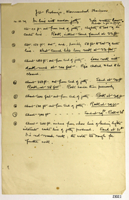
Document - Report, Jet Probings, Warrnambool Harbour, 16-10-1929
... ...Breakwater...Jetty...Pier...The results could determine plans for future engineering works. document depth warrnambool harbour 1929 soundings jet probe jet probing seabed map of seabed underwater engineering warrnambool jetty warrnambool breakwater breakwater upgrade leading lights chart the harbour Flagstaff Hill Warrnambool Flagstaff Hill Maritime Museum & Village Maritime Museum Maritime Village shipwreck coast Lady Bay Port of Warrnambool Breakwater Jetty Pier VHR H2024 Royal Commission 1923 Public Works Water Commission Harbour Trust Victorian Harbours Report, titled 'Jet Probings, Warrnambool Harbour'. ...This report lists the depths of water and the consistency of the seabed surrounding the Warrnambool Harbour in October 1929, The information, often referred to as 'soundings', was obtained by Jet Probing,. In earlier days a lead line was used to perform a similar task. The author of the document is unknown. Jet Probing is a method used for underwater archaeology, cable installation and coastal engineering. A jet probe is a machine that produces a strong jet of water that penetrates the layers of sediment on the seabed, determining their depth, thickness and consistency. It provides a survey of the seabed and can be used as an aid to engineering design and construction. The report mentions lining up with the wooden jetty, the end of the breakwater and the leading lights. It mentions sand, loose rock and rock. It tells of stopping work due to the water being too rough, the pipe choking, difficulty in connecting pipes, and pipe joint breaking as it tried to get through the sand, The report in the document is significant for its connection with the Warrnambool Harbour, Warrnambool Breakwater, Warrnambool Jetty and Lady Bay. The report gives figures for the depth and consistency of the water and seabed at a particular point in time and can be used to compart with similar figures taken at different times. The results could determine plans for future engineering works.Report, titled 'Jet Probings, Warrnambool Harbour'. Two pages of cream coloured paper with hand written notes in pen and ink. Report covers three days of Jet Probings, with resulting figures and comments, for the depths of the surroundings of the Warrnambool Harbour. The report is in point form, with some underlining. Dates of recordings are 14-10-29, 15-10-29 and 16-10-29. (1929) The situation of the harbour had become a real problem by 1910 and required continuous dredging. In 1914 the Breakwater was extended but proved to be a failure because the work began to subside and by 1920 about two thirds of the harbour was silted up. Alterations made in the 1920's increased the silting problem. The soundings and Jet Probings were done after the Royal Commission of 1923, when the damaged stonework on the seaward side of the Warrnambool Breakwater, caused by the action of the sea, was the subject of enquiry. A conference between the Public Works, Water Commission and the Harbour Trust concluded that it would less costly to make repairs to prevent further damage rather than replaced the damage portion of the wall. A contract was raised in late 1924 to deposit rubble on the damaged side of the breakwater to minimise the Southern Ocean’s destructive action and work had started by August 1925. By the 1940's the harbour was no longer used. More alterations were made in the 1950's and 1960's. document, depth, warrnambool harbour, 1929, soundings, jet probe, jet probing, seabed, map of seabed, underwater engineering, warrnambool jetty, warrnambool breakwater, breakwater upgrade, leading lights, chart the harbour, flagstaff hill, warrnambool, flagstaff hill maritime museum & village, maritime museum, maritime village, shipwreck coast, lady bay, port of warrnambool, breakwater, jetty, pier, vhr h2024, royal commission, 1923, public works, water commission, harbour trust, victorian harbours -
 Flagstaff Hill Maritime Museum and Village
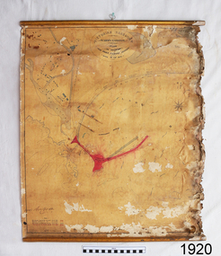
Document - Plan, Victorian Harbours Warrnambool, Victorian Harbours, Warrnambool, Plan to Accompany Sir John Coode's Report, 28-02-1879
... ...Breakwater...Jetty...Pier...While the Warrnambool Breakwater is a demonstration of the engineering skills of the nineteenth century, it also demonstrates the limitations of knowledge relating to sedimentology at the time and the confidence apparent in a number of nineteenth century plans which assumed that natural forces could be overcome or contained by engineering. flagstaff hill warrnambool maritime museum shipwreck coast great ocean road sir john coode borough of warrnambool surveyor plan of warrnambool victorian harbours warrnambool harbour warrnambool breakwater port of warrnambool vhd vhr h2024 Flagstaff Hill Maritime Museum & Village Maritime Village Map chart plan Lady Bay Breakwater Jetty Pier VHR H2024 proposed works 1879 Stamped "VICTORIAN HARBOURS / WARRNAMBOOL / PLAN / to accompany / SIR JOHN GOODE'S REPORT / DATED 28 FEB 1879" Signature "John Coode" Plan of Warrnambool Harbour, Port of Warrnambool, dated 28 Feb 1879. ...This plan is of great significance to the local history of Warrnambool, in particular the Breakwater and its impact on Warrnambool's maritime and trade history. The plan shows the existing jetties at the Port of Warrnambool, plus the partially erected Breakwater and proposed works to the Breakwater by both the Borough of Warrnambool Surveyor and Sir John Coode. The plan was signed 28th February 1879 by Sir John Coode. The legend at the bottom left describes the existing works and the proposed works. The Warrnambool Breakwater Sir John Coode was a British harbour engineer. He was brought to Melbourne by the Melbourne Harbour Trust to advise on works to improve the Port of Melbourne. The Victorian Government commissioned him to present a plan to complete the Warrnambool Breakwater. His original plan was too expensive so he prepared a revised plan for a shorter structure. The work was completed in 1890. The construction proved to be too short to protect adequately from the weather and didn't allow enough depth for larger vessels to come into port. The decreasing trade was further affected by siltation in the bay due to the breakwater, and the completion of the railway line. The situation of the harbour became a real problem that, by 1910, required continuous dredging. In 1914 the Breakwater was extended but proved to be a failure because the work began to subside and by 1920 about two thirds of the harbour was silted up. Alterations made in the 1920's increased the silting problem and by the 1940's the harbour was no longer used. More alterations were made in the 1950's and 1960's. The Warrnambool Breakwater is registered as a place of significance on the Victorian Heritage Database. This plan of the proposed works for the existing Warrnambool Breakwater is of great significance to the local history of Warrnambool, in particular the Breakwater and its impact on Warrnambool's maritime and trade history. The Warrnambool Breakwater is registered as a place of significance on the Victorian Heritage Database (VHR H2024). It is historically significant to Victoria as one of the most important maritime engineering projects in Victoria in the late 19th century. The Warrnambool Breakwater is of historical significance as one of the most important maritime engineering projects in Victoria in the late nineteenth century. It is evidence of Victoria's nineteenth century investment in regional port infrastructure and the development of Victorian coastal shipping. It is of significance for its association with the English civil engineer Sir John Coode, the most distinguished harbour engineer of the nineteenth century, who was brought to Victoria to advise on works to improve the Port of Melbourne, but was retained by the Government to advise on improvements to the harbours at Portland, Geelong, Port Fairy, and Lakes Entrance, as well as Warrnambool. His projects for Melbourne, Lakes Entrance and Warrnambool were major engineering projects of the nineteenth century. The breakwater is historically significant as a reminder of Warrnambool's early maritime history as a Western District port, and as one of Victoria's major 'outer ports'. While the Warrnambool Breakwater is a demonstration of the engineering skills of the nineteenth century, it also demonstrates the limitations of knowledge relating to sedimentology at the time and the confidence apparent in a number of nineteenth century plans which assumed that natural forces could be overcome or contained by engineering.Plan of Warrnambool Harbour, Port of Warrnambool, dated 28 Feb 1879. Plan shows existing Breakwater and work proposed by both Warrnambool Borough Surveyor and Sir John Coode. Plan has gold coloured quarter-dowel rods top and bottom and a metal ring at the top. Stamped with title. Signed by Sir John Coode.Stamped "VICTORIAN HARBOURS / WARRNAMBOOL / PLAN / to accompany / SIR JOHN GOODE'S REPORT / DATED 28 FEB 1879" Signature "John Coode"flagstaff hill, warrnambool, maritime museum, shipwreck coast, great ocean road, sir john coode, borough of warrnambool surveyor, plan of warrnambool, victorian harbours, warrnambool harbour, warrnambool breakwater, port of warrnambool, vhd vhr h2024, flagstaff hill maritime museum & village, maritime village, map, chart, plan, lady bay, breakwater, jetty, pier, vhr h2024, proposed works, 1879 -
 Flagstaff Hill Maritime Museum and Village
Document - Navigation Chart, Admiralty Office, Lady Bay and Warrnambool Harbour, 03/04/1871
... ...Breakwater...Jetty...Pier...Richards Edward Weller Port of Warrnambool flagstaff Hill Maritime Museum & Village Maritime Museum Maritime Village shipwreck coast Map chart Navigation chart Admiralty Chart Breakwater Jetty Pier VHR H2024 Top of chart has logo "HYDROGRAPHER OFFICE" "Price Eighteen Pence". ...This Chart titled “Lady Bay and Warrnambool Harbour” was surveyed by Nav. Lieut. H.J. Stanley, of Britain's Royal Navy, in 1870 and printed in April 1871. The chart was made before the Warrnambool Breakwater was built (construction had begun in 1874 and was completed in 1890). The chart includes Directions for entering Lady Bay, Warrnambool Harbour. These are "Vessels entering Warrnambool Harbour must bring the Red Light in sight and steer in with it in line with the upper white Light bearing North, until the Green Light on the Jetty is opened, when steer towards it and anchor. The best anchorage is in 2 ¼ fms [fathoms)] of water, about a cable from ledge off Breakwater rock. Or where convenient, according to draught of water, only endeavouring to anchor as close as possible to Breakwater rock. It is not safe to enter or leave the Harbour in south westerly or Southerly gales.” This chart is significant for its strong connection to the maritime history of Warrnambool Harbour and Lady Bay, and eventually to the Warrnambool Breakwater. The Warrnambool Breakwater is registered as a place of significance on the Victorian Heritage Database (VHR H2024). A copy of the same chart was used to plan several submissions for future changes to the jetty and breakwater. The chart is a historical record of structures existing in 1870; the Warrnambool Jetties, Lady Bay, the leading lights (lighthouses), streets, roads, bridges and many buildings. It also shows the lay of the land and seabed.Canvas chart of Australia, South Coast, Victoria Title: Lady Bay and Warrnambool Harbour Surveyed by Nav. Lieut. H.J. Stanley, R.N., 1870. Magnet Variation, 1870 Published April 3, 1871, by the Admiralty, London. Directions for vessels entering Warrnambool Harbour are printed on the chart. The chart has a lacquer or seal over it.Top of chart has logo "HYDROGRAPHER OFFICE" "Price Eighteen Pence". "Engraved by Edward Weller" Along bottom of Chart: “London… Published at the Admiralty, 3rd April 1871, under the Superintendence of Rear Admiral G.H. Richards, F.R.S. Hydrographer, Corrections July 71” Bottom of chart “Australia South Coast Victoria Lady Bay and Warrnambool Harbour. 2494”flagstaff hill, warrnambool, chart of lady bay warrnambool 1870, warrnambool harbour, cartography, navigation, warrnambool breakwater, 1871, australia – south coast / victoria, lady bay, 1870, nav. lieut. h.j. stanley, r.n, directions for entering warrnambool harbour, hydrographer office, rear admiral g.h. richards, edward weller, port of warrnambool, flagstaff hill maritime museum & village, maritime museum, maritime village, shipwreck coast, map, chart, navigation chart, admiralty chart, breakwater, jetty, pier, vhr h2024 -
Glenelg Shire Council Cultural Collection
Photograph - Photograph - harbour dredging, n.d
... Portland, Fishermens breakwater, Little Pier, Ocean Pier in background....Portland, Fishermens breakwater, Little Pier, Ocean Pier in background. Photograph Photograph - harbour dredging ...Port of Portland Authority Archivesport of portland archives, portland harbour, dredging -
 Queenscliffe Maritime Museum
Photograph - Photographs of a family picnic, old piers & breakwaters at Queenscliffe scenery, Photograph of family picnic & scenery, unknown
... black and white photograph of old piers, breakwaters and a family picnic...Queenscliffe Maritime Museum 2 Wharf St Queenscliff geelong-and-the-bellarine-peninsula gaff-rigged fishing boat fishing boat Refer Notes section for details black and white photograph of old piers, breakwaters and a family picnic Photograph of family picnic & scenery Photograph Photographs of a family picnic, old piers & breakwaters at Queenscliffe scenery ...gaff-rigged fishing boatblack and white photograph of old piers, breakwaters and a family picnicRefer Notes section for detailsfishing boat -
Glenelg Shire Council Cultural Collection
Photograph - Photograph - Main Breakwater construction, Portland, n.d
... Black and white aerial photo of the harbour, showing early stage Lee Breakwater, Ocean Pier, with ship berthed, railway pier, Fishermen's Breakwater. ...Glenelg Shire Council Cultural Collection History House Cliff Street Portland great-ocean-road Port of Portland Authority Archives Port of Portland Archives harbour construction main breakwater Front: Purplestamp- '14 Feb 1958" Back: Purple stamp- '14 Feb 1958' Black and white aerial photo of the harbour, showing early stage Lee Breakwater, Ocean Pier, with ship berthed, railway pier, Fishermen's Breakwater. ...Port of Portland Authority ArchivesFront: Purplestamp- '14 Feb 1958" Back: Purple stamp- '14 Feb 1958'port of portland archives, harbour construction, main breakwater -
Glenelg Shire Council Cultural Collection
Photograph - Photograph - Main Breakwater construction, Portland, n.d
... Black and white aerial photo of the harbour, showing early stage Lee Breakwater, Ocean Pier, with ship berthed, Railway Pier, Fishermen's Breakwater. ...Glenelg Shire Council Cultural Collection History House Cliff Street Portland great-ocean-road Port of Portland Authority Archives Port of Portland Archives aerial photography Portland Harbour Front: Purple stamp- '14 Jan 1958' Back: Purplestamp- '14 Jan 1958' Black and white aerial photo of the harbour, showing early stage Lee Breakwater, Ocean Pier, with ship berthed, Railway Pier, Fishermen's Breakwater. ...Port of Portland Authority ArchivesFront: Purple stamp- '14 Jan 1958' Back: Purplestamp- '14 Jan 1958'port of portland archives, aerial photography, portland harbour -
Glenelg Shire Council Cultural Collection
Photograph - Photograph - Main Breakwater, Portland, n.d
... breakwater... construction... Ocean Pier...Black & white photo of shore end of main breakwater construction site, taken from south. Man standing on point. Ocean Pier, left background, view to Dutton Way....Glenelg Shire Council Cultural Collection History House Cliff Street Portland great-ocean-road Port of Portland Authority Archives Port of Portland Archives main breakwater construction Ocean Pier Dutton Way Black & white photo of shore end of main breakwater construction site, taken from south. ...Port of Portland Authority Archivesport of portland archives, main breakwater, construction, ocean pier, dutton way -
Glenelg Shire Council Cultural Collection
Photograph - Photograph - Portland, Victoria, n.d
... Fishermen's breakwater, Railway Pier, Ocean Pier, baths, gardens...Fishermen's breakwater, Railway Pier, Ocean Pier, baths, gardens Photograph Photograph - Portland, Victoria ...Black and white photo taken from Battery Point, looking north. Fishermen's breakwater, Railway Pier, Ocean Pier, baths, gardensbattery point, fishermans breakwater, portland harbour, public baths -
Glenelg Shire Council Cultural Collection
Photograph - Photograph - Portland Harbour, c. 1950
... Black and white aerial photo of Portland Harbour showing Fishermen's Breakwater, Railway Pier, Ocean Pier and SL Paterson wharf under construction...Glenelg Shire Council Cultural Collection History House Cliff Street Portland great-ocean-road Port of Portland Authority Archives Port of Portland Archives Portland Harbour Black and white aerial photo of Portland Harbour showing Fishermen's Breakwater, Railway Pier, Ocean Pier and SL Paterson wharf under construction Photograph Photograph - Portland Harbour ...Port of Portland Authority Archivesport of portland archives, portland harbour -
Glenelg Shire Council Cultural Collection
Negative - Negative - Portland Harbour, ZILLAH MASCHMEDT, PHOTOGRAPHER, c. 1934
... View from Ocean Pier, looking back to Portland. Bollard in foreground. Fisherman's Breakwater, Railway Pier, town in background...View from Ocean Pier, looking back to Portland. Bollard in foreground. Fisherman's Breakwater, Railway Pier, town in background Negative Negative - Portland Harbour ZILLAH MASCHMEDT, PHOTOGRAPHER ...NEGATIVE FOR BLACK AND WHITE PHOTOGRAPH. View from Ocean Pier, looking back to Portland. Bollard in foreground. Fisherman's Breakwater, Railway Pier, town in backgroundnegative, portland seafront, harbour, pier, deep water pier