Showing 195 items matching "bush land"
-
 Halls Gap & Grampians Historical Society
Photograph - Sepia, C 1920s
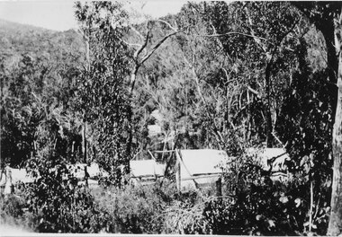
... Photo shows a number of tents in bush land, said to be road makers camp...Halls Gap & Grampians Historical Society Centennial Hall 117-119 Grampians Road Halls Gap grampians Photo is said to be that of roadmakers camp for workers on the construction of the Mt Victory Road STRUCTURES Tents ACCESS ROUTES Road building Road makers camp Mt Victory Rd during the dat 1920s Photo shows a number of tents in bush land, said to be road makers camp Photograph Sepia ...Photo is said to be that of roadmakers camp for workers on the construction of the Mt Victory RoadPhoto shows a number of tents in bush land, said to be road makers campRoad makers camp Mt Victory Rd during the dat 1920sstructures, tents, access routes, road building -
 Wangaratta RSL Sub Branch
Photograph, c1940
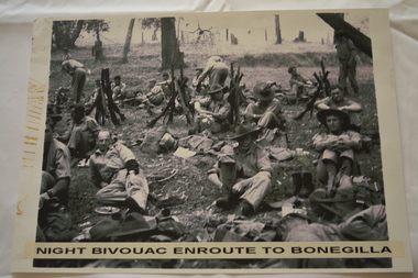
... Reproduced black and white photograph of unknown soldiers sitting on the ground in bush land....The Unit was granted the Freedom of the City by the Rural City of Wangaratta in 1990 and one of the first, if not the first, to receive this type of honour. 2/24th battalion wangaratta Night bivouac enroute to Bonegilla Reproduced black and white photograph of unknown soldiers sitting on the ground in bush land. Photograph Photograph ...In July 1940, the 2/24th Battalion was formed in Wangaratta. On the 27th September, after weeks of hard training the Battalion marched out to Bonegilla to continue training prior to overseas deployment to the Middle East in November, 1940. This image depicts soldiers resting during the 60 mile march.The 2/24th Battalion was an infantry battalion of the Australian Army, which served during World War II .A unit of all-volunteers, it was formed in July 1940 from primarily Victorian volunteers and was known as "Wangaratta's Own" because of the time the battalion spent in the town during its formative period prior to deployment overseas. It served in North Africa in 1941–1942 as part of the 26th Brigade, which was assigned to the 7th Division, before being reassigned to the 9th Division. In early 1943, the battalion returned to Australia and later took part in campaigns against the Japanese in New Guinea in 1943–1944 and Borneo in 1945, before being disbanded in 1946. The 2/24th suffered the highest number of casualties of any 2nd AIF infantry battalion. The Unit was granted the Freedom of the City by the Rural City of Wangaratta in 1990 and one of the first, if not the first, to receive this type of honour.Reproduced black and white photograph of unknown soldiers sitting on the ground in bush land. Night bivouac enroute to Bonegilla2/24th battalion, wangaratta -
 Bendigo Historical Society Inc.
Document - Michele Matthews collection - paperwork and reports for re-zoning of Maiden Gully (1993 - 1996). Residents opposed the re-zoning as they had purchased land as "bush blocks", 25/02/2025
... Residents opposed the re-zoning as they had purchased land as "bush blocks"...Residents opposed the re-zoning as they had purchased land as "bush blocks" Coliban water Annual report 1993/94 21/12/1994 Maiden Gully Development Committee - newsletter No 1 - cttee met with representatives of Coliban Water Caliban Water information Bulletin January 1995 - Maiden Gully Sewerage Scheme 22/02/1995 Maiden Gully Development Committee - newsletter No 2 - cttee activities re the planned sewerage scheme 27/03/1995 - Coliban Water letter to WR & MS Matthews, owners 3 Clay Gully Court (Lot 56 LP 212245) undated - Maiden Gully Neighborhood Sewerage Schemes - Robin Hill Estate Scheme (cost allocation to property owners 21/04/1995 five-page letter of objection/complaint from WR & MS Matthews, owners 3 Clay Gully Court, re costs allocated against their property (Lot 56 LP 212245) 16/06/1995 five-page response from Coliban Water to WR & MS Matthews, owners 3 Clay Gully Court; regarding the outcome of their objection to the sewerage scheme 22/08/1995 letter from WR & MS Matthews, to resident re the results of their objections (and consequent concessions) from Coliban Water re the Robin Hill Estate Sept 1995 Maiden Gully Structure Plan, prepared by TEA planners & Planning Australia Consultants; provides a structure plan, for the Rural City of Marong, the propose future development of the Maiden Gully area Greater Bendigo Planning Scheme - Amendment L43 - Maiden Gully Township: * undated and author unstated - Maiden Gully questions sheet for residents re the proposed Maiden Gully Structure Plan - seven questions and answers * Fauna species - observed /recorded site 6; Maiden Gully (off Pioneer drive) * Explanatory report, three pages * 1/11/1995 Notice of Amendment to a Planning Scheme * Greater Bendigo Planning Scheme, Chapter 6, Amendment L43 (five pages) December 1995 Coliban Water "In the Pipe line", Maiden Gully Region Community Newsletter No 2 - Halfway mark for Sewerage Scheme March 1996 Coliban Water "In the Pipe line", Maiden Gully Region Community Newsletter No 3 - Home stretch for new sewer scheme May 1996 Coliban Water "In the Pipe line", Maiden Gully Region Community Newsletter No 4 - New sewerage scheme comes in well under budget Undated - Maiden Gully Township - Amendment L43 - Panel Hearing report (31 pages) ...Residents opposed the re-zoning as they had purchased land as "bush blocks" ...documents for Maiden Gully Sewerage SchemeMichele Matthews collection - paperwork and reports for re-zoning of Maiden Gully (1993 - 1996). Residents opposed the re-zoning as they had purchased land as "bush blocks" Coliban water Annual report 1993/94 21/12/1994 Maiden Gully Development Committee - newsletter No 1 - cttee met with representatives of Coliban Water Caliban Water information Bulletin January 1995 - Maiden Gully Sewerage Scheme 22/02/1995 Maiden Gully Development Committee - newsletter No 2 - cttee activities re the planned sewerage scheme 27/03/1995 - Coliban Water letter to WR & MS Matthews, owners 3 Clay Gully Court (Lot 56 LP 212245) undated - Maiden Gully Neighborhood Sewerage Schemes - Robin Hill Estate Scheme (cost allocation to property owners 21/04/1995 five-page letter of objection/complaint from WR & MS Matthews, owners 3 Clay Gully Court, re costs allocated against their property (Lot 56 LP 212245) 16/06/1995 five-page response from Coliban Water to WR & MS Matthews, owners 3 Clay Gully Court; regarding the outcome of their objection to the sewerage scheme 22/08/1995 letter from WR & MS Matthews, to resident re the results of their objections (and consequent concessions) from Coliban Water re the Robin Hill Estate Sept 1995 Maiden Gully Structure Plan, prepared by TEA planners & Planning Australia Consultants; provides a structure plan, for the Rural City of Marong, the propose future development of the Maiden Gully area Greater Bendigo Planning Scheme - Amendment L43 - Maiden Gully Township: * undated and author unstated - Maiden Gully questions sheet for residents re the proposed Maiden Gully Structure Plan - seven questions and answers * Fauna species - observed /recorded site 6; Maiden Gully (off Pioneer drive) * Explanatory report, three pages * 1/11/1995 Notice of Amendment to a Planning Scheme * Greater Bendigo Planning Scheme, Chapter 6, Amendment L43 (five pages) December 1995 Coliban Water "In the Pipe line", Maiden Gully Region Community Newsletter No 2 - Halfway mark for Sewerage Scheme March 1996 Coliban Water "In the Pipe line", Maiden Gully Region Community Newsletter No 3 - Home stretch for new sewer scheme May 1996 Coliban Water "In the Pipe line", Maiden Gully Region Community Newsletter No 4 - New sewerage scheme comes in well under budget Undated - Maiden Gully Township - Amendment L43 - Panel Hearing report (31 pages) maiden gully, sewerage scheme -
 Wangaratta RSL Sub Branch
Photograph, c1940
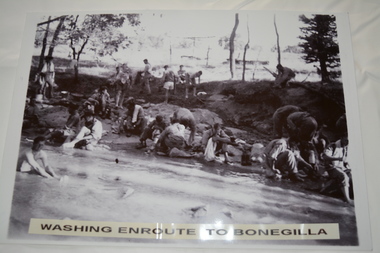
... Reproduced black and white photograph of unknown soldiers bathing and sitting on a river bank in bush land....The Unit was granted the Freedom of the City by the Rural City of Wangaratta in 1990 and one of the first, if not the first, to receive this type of honour. 2/24th battalion wangaratta Washing enroute to Bonegilla Reproduced black and white photograph of unknown soldiers bathing and sitting on a river bank in bush land. Photograph Photograph ...In July 1940, the 2/24th Battalion was formed in Wangaratta. On the 27th September, after weeks of hard training the Battalion marched out to Bonegilla to continue training prior to overseas deployment to the Middle East in November, 1940. This image depicts soldiers bathing and washing during the 60 mile march.The 2/24th Battalion was an infantry battalion of the Australian Army, which served during World War II .A unit of all-volunteers, it was formed in July 1940 from primarily Victorian volunteers and was known as "Wangaratta's Own" because of the time the battalion spent in the town during its formative period prior to deployment overseas. It served in North Africa in 1941–1942 as part of the 26th Brigade, which was assigned to the 7th Division, before being reassigned to the 9th Division. In early 1943, the battalion returned to Australia and later took part in campaigns against the Japanese in New Guinea in 1943–1944 and Borneo in 1945, before being disbanded in 1946. The 2/24th suffered the highest number of casualties of any 2nd AIF infantry battalion. The Unit was granted the Freedom of the City by the Rural City of Wangaratta in 1990 and one of the first, if not the first, to receive this type of honour.Reproduced black and white photograph of unknown soldiers bathing and sitting on a river bank in bush land. Washing enroute to Bonegilla2/24th battalion, wangaratta -
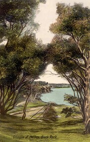 City of Kingston
Postcard - Postcard, Colour, E. Soffa, Glimpse of the sea, Black Rock, c. 1920
... ...Bush Land...Holiday Postcard Black Rock Bush Land Seaside Colour postcard feturing a hand tinted photographic image taken from a height, looking down to the sea through bushland. ...Postcards began to be produced in Victoria from 1876. Between 1900 and 1920, picture postcards in Australia became an incredibly popular phenomenon. People could cheaply and easily send messages, without the formality of a letter, and they provided a cheap form of souvenir. Eventually, every event of significance was commemorated in some way with a postcard, and this led to the development of a ‘picture on one side and a message/stamp on the other’ postcard we are familiar with today. They were also a popular form of advertising. This postcard appears to be one in a set of postcards promoting the Black Rock area.Colour postcard feturing a hand tinted photographic image taken from a height, looking down to the sea through bushland.holiday, postcard, black rock, bush land, seaside -
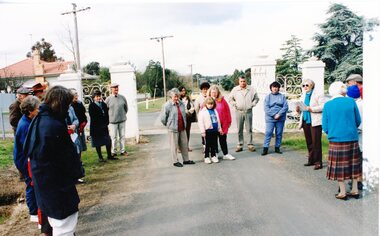 Stawell Historical Society Inc
Photograph, Cemetery Crowd
... 5 Colour Photographs: showing a group of people at various locations looking at Graves, Monuments and a bush land site. ...With houses in the background. 7083-3 A Group of People lookning at graves. 7083-4 A Group of People on a dirt road over a small bridge, with a white ute in right foreground. 5 Colour Photographs: showing a group of people at various locations looking at Graves, Monuments and a bush land site. Cemetery Crowd Photograph ...7083. A Groupd of People standing inside the Cemetery Gates Stawell. 7083-1 A Group of people looking at a fenced headstone 7083-2 A Group of people looking at a Monument. With houses in the background. 7083-3 A Group of People lookning at graves. 7083-4 A Group of People on a dirt road over a small bridge, with a white ute in right foreground.5 Colour Photographs: showing a group of people at various locations looking at Graves, Monuments and a bush land site. -
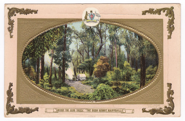 Marysville & District Historical Society
Postcard (item) - Colour postcard, Nicholas John Caire, "Amidst the Gum Trees." "The Bush Hermit, Marysville.", 1858-1918
... Printed postcard featuring a coloured photograph of a small hut in the bush land at Marysville, Victoria. The oval shaped photograph is surrounded by a gold printed frame, the Australian coat of arms is centered at top....To Dear Emily/ With every loving/ Wish for many/ happy birthday/ with love from me/ Myrtle Printed postcard featuring a coloured photograph of a small hut in the bush land at Marysville, Victoria. The oval shaped photograph is surrounded by a gold printed frame, the Australian coat of arms is centered at top. ...A postcard of a photograph taken by socialite photographer Nicholas John Caire. N.J. Caire had a great love for the area and in the late 1800's took many photographs of Marysville and its surrounds.One of a series of postcards of photographs taken by socialite photographer Nicholas John Caire. N.J. Caire had a great love for the area in and surrounding Marysville and in the late 1800's took many photographs of Marysville and its surrounds. N.J. Caire was born in 1837 in Guernsey. He arrived in Adelaide about 1860 along with his parents who encouraged his early interest in photography. He opened a studio in Adelaide in 1867 after traveling extensively throughout the Gippsland taking photographs. After marrying in 1870 he moved to Talbot in Victoria until 1876 when he opened a studio in the Royal Arcade in Melbourne. After 1885 N.J. Caire gave up his city work and made his home in South Yarra and devoted the rest of his life to outdoor photography, specializing in the bush, the gullies and the mountains of south-eastern Victoria. POST CARD A.G.J. AFFIX/ STAMP THIS SPACE MAY BE USED/ FOR COMMUNICATION. THE ADDRESS ONLY TO BE/ WRITTEN HERE. Printed in Saxony COPYRIGHT. To Dear Emily/ With every loving/ Wish for many/ happy birthday/ with love from me/ Myrtlemarysville, victoria, george, george locke, nicholas john caire, cumberland valley, hermit, postcard, souvenir -
 Bendigo Historical Society Inc.
Document - BUSH COLLECTION: HISTORY OF ALBERT BUSH'S LAND PURCHASES AND PRODUCE STORE ON THE CORNER OF MYERS & WILLIAMSON STREETS, BENDIGO
... BUSH COLLECTION: HISTORY OF ALBERT BUSH'S LAND PURCHASES AND PRODUCE STORE ON THE CORNER OF MYERS & WILLIAMSON STREETS, BENDIGO...History of land purchases made by Albert Bush in Bendigo and his Produce Store on the corner of Williamson & Myers Streets, Bendigo Eight sheets covering Albert Bush's land purchases History sheets in various page formats...History House 11 Mackenzie Street Bendigo goldfields History of land purchases made by Albert Bush in Bendigo and his Produce Store on the corner of Williamson & Myers Streets, Bendigo Eight sheets covering Albert Bush's land purchases History sheets in various page formats Document BUSH COLLECTION: HISTORY OF ALBERT BUSH'S LAND PURCHASES AND PRODUCE STORE ON THE CORNER OF MYERS & WILLIAMSON STREETS, BENDIGO ...History of land purchases made by Albert Bush in Bendigo and his Produce Store on the corner of Williamson & Myers Streets, Bendigo Eight sheets covering Albert Bush's land purchases History sheets in various page formats -
 Bendigo Historical Society Inc.
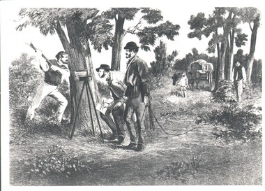
Photograph - WES HARRY COLLECTION: SURVEY PARTY, 1854
... The whole group is in a bush land setting....The whole group is in a bush land setting. Photograph WES HARRY COLLECTION: SURVEY PARTY ...Photograph of a drawing depicting a survey party in 1854. In the left foreground there are Two men, one is looking through a theodolite, and another is blazing a mark on to a tree with an axe. Two other men are dragging a chain measure. In the background there is a boy standing by a horse and cart. The whole group is in a bush land setting.organization, lands and survey, original survey, surveying, theodilite, chain -
 Bendigo Historical Society Inc.
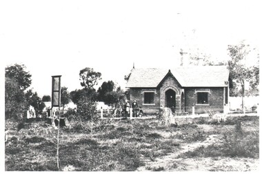
Photograph - WES HARRY COLLECTION: WHITE HILLS CEMETERY, 1860's
... At the White Hills Cemetery, it is in a single storied brick structure in a bush land setting. There is a noticeboard on the left of the photo and a post and wire fence along the front of the building. ...At the White Hills Cemetery, it is in a single storied brick structure in a bush land setting. There is a noticeboard on the left of the photo and a post and wire fence along the front of the building. ...Photograph of the Chapel? At the White Hills Cemetery, it is in a single storied brick structure in a bush land setting. There is a noticeboard on the left of the photo and a post and wire fence along the front of the building. One person is standing in the doorway and two adults and a small child to the left. There are three more adults on the extreme left-hand side, near the entrance to the cemetery.Batchelderplace, cemetery, white hills cemetery, batchelder -
 Bendigo Historical Society Inc.
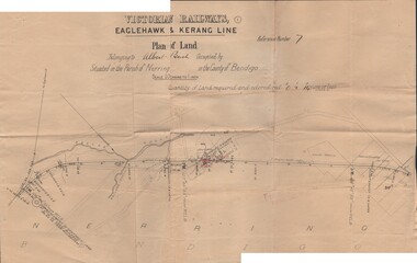
Document - BUSH COLLECTION: PLANS PERTAINING TO LAND OF S. A. BUSH
... BUSH COLLECTION: PLANS PERTAINING TO LAND OF S. A. BUSH...B: Victoria Railways, Eaglehawk & Kerang Line (Albert Bush land, Parish of Nerring, County of Bendigo....B: Victoria Railways, Eaglehawk & Kerang Line (Albert Bush land, Parish of Nerring, County of Bendigo. ...A: Plan of subdivision of Allots 6, 7, 8, 15 & 16, Sec. 62C, City of Bendigo (The Property of Albert Bush, Esq.) - Plan is torn in half forming two pieces (see 'Condition'. Pinned note attached to one piece. B: Victoria Railways, Eaglehawk & Kerang Line (Albert Bush land, Parish of Nerring, County of Bendigo.person, individual, bush collection - personal -
 Bendigo Historical Society Inc.
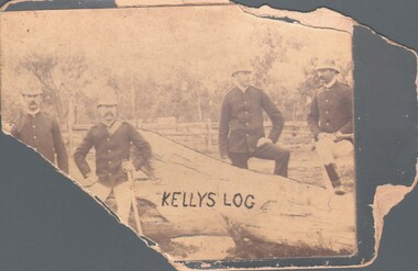
Photograph - HARRY BIGGS COLLECTION: KELLY'S LOG
... There is a post and Rail fence visible in the background with bush land behind. A deputation from the Bendigo Historical Society presented a copy of this photo to the Beechworth Museum. ...There is a post and Rail fence visible in the background with bush land behind. A deputation from the Bendigo Historical Society presented a copy of this photo to the Beechworth Museum. ...Photograph of four policemen leaning against a fallen tree with the words Kelly's log painted on the tree. One of the men is holding a gun and another has a sword at his side. There is a post and Rail fence visible in the background with bush land behind. A deputation from the Bendigo Historical Society presented a copy of this photo to the Beechworth Museum. They did not have it in their colllection. Reference: Newspaper article, Bendigo Advertiser, dated 26.3.1969person, group, policemen, kelly's log -
 Eltham District Historical Society Inc
Negative - Photograph, St. Andrew's Hotel
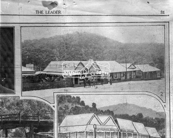
... Shows a man on horseback and various people stand out the front with bush land in the background. In 1929, St Andrews was known as Queenstown....Shows a man on horseback and various people stand out the front with bush land in the background. In 1929, St Andrews was known as Queenstown. ...Queenstown (St. Andrews) District. Originally published in The Leader, Nov. 2nd, 1929, with the title "Relics of the Old Mining days in the Queenstown District," a series of eigth numbered photographs. 'The Leader'; a weekly journal of news, politics, agriculture, literature, science and sport. Shows a man on horseback and various people stand out the front with bush land in the background. In 1929, St Andrews was known as Queenstown.This photo forms part of a collection of photographs gathered by the Shire of Eltham for their centenary project book, "Pioneers and Painters: 100 years of the Shire of Eltham" by Alan Marshall (1971). The collection of over 500 images is held in partnership between Eltham District Historical Society and Yarra Plenty Regional Library (Eltham Library) and is now formally known as 'The Shire of Eltham Pioneers Photograph Collection.' It is significant in being the first community sourced collection representing the places and people of the Shire's first one hundred years.Digital image 4 x 5 inch B&W Negsepp, shire of eltham pioneers photograph collection, queenstown, st andrews hotel, st. andrews -
 Port of Echuca
Colour Photograph, Approx.1979
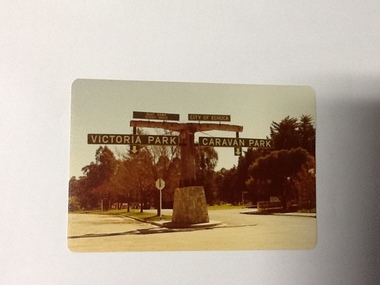
... It is still the primary sporting ground in Echuca, offering AFL football oval, cricket pitch and nets, athletics and entry to the Echuca boat ramp and the natural bush land of the scenic drive. It also houses Echuca Council caravan park. ...It is still the primary sporting ground in Echuca, offering AFL football oval, cricket pitch and nets, athletics and entry to the Echuca boat ramp and the natural bush land of the scenic drive. It also houses Echuca Council caravan park. ...In 1869 the Council moved to name this park "Victoria Park. The cricket pitch construction began in 1873 and major improvements to the ground were undertaken in 1881. It is still the primary sporting ground in Echuca, offering AFL football oval, cricket pitch and nets, athletics and entry to the Echuca boat ramp and the natural bush land of the scenic drive. It also houses Echuca Council caravan park. The signage in this photograph is no longer there and the enterance to the caravan park has moved.This area of Echuca has historically been a major recreational area for the town. Being the primary sporting ground since its establishment in 1869., the area has a number of sporting and recreational facilities for the people of Campaspe Shire, from natural bush walks in and along the Murray river to more formal facilities such as AFL football ground, firefighting training area, netball courts, cricket pitch and nets, and grass tennis courts. Colour photograph (post-card size) of directory signs to entrance of Victoria Park, Echuca taken facing north. Two driveways are shown, to the east "Caravan Park" and to the west , "Victoria Park", "Boat ramp", " Scenic drive"Printed in black on the reverse:"this paper manufactured by Kodak"echuca, port of, echuca council caravan park, victoria park, echuca, echuca-tourist attraction -
 Nillumbik Shire Council
Painting: Eric Stephensen (b.1916), Silent Lagoon, 1966, 1966
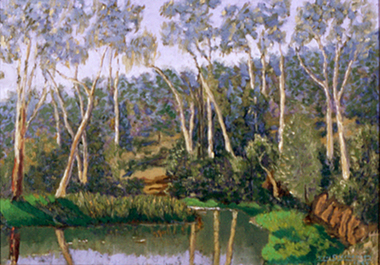
... The surrounding landscape is reflected in the water. Sloping land and bush fill the background....The surrounding landscape is reflected in the water. Sloping land and bush fill the background. Silent Lagoon, 1966 Painting: Eric Stephensen (b.1916) ...Oil on canvas. Painted at Art Historian, Bernard Smith's dam beside Karingal Drive in Eltham, Victoria. Rich, green shrubs and eucalyptus trees surround the water, reeds grow in the dam. The surrounding landscape is reflected in the water. Sloping land and bush fill the background. -
 Bendigo Historical Society Inc.
Document - LYDIA CHANCELLOR COLLECTION: 93 MOLLISON STREET, BENDIGO
... Albert Bush first bought the land in 1865 and built the house in 1865. ...Albert Bush first bought the land in 1865 and built the house in 1865. ...A six page document containing information on 93 Mollison Street Bendigo. Mr. Albert Bush first bought the land in 1865 and built the house in 1865. Included with the information is a letter to Miss Huxtable from Mr. Bob (Robert G.) Herriot an architect who purchased the house in 1973.bendigo, house, 93 mollison street, lydia chancellor collection, collection, building, home, albert bush, bendigo, house, houses, residence, mollison street, mr. robert g. herriot, architect -
 Bendigo Historical Society Inc.
Photograph - LONG GULLY HISTORY GROUP COLLECTION: BEFORE LONG GULLY ESTATE WAS BUILT
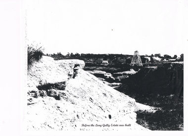
... Black and white copy of an Allan Doney photo some houses, poppet legs, vacant land and bush. Foreground is uneven ground. Printed titled stuck on the bottom of the photo is: Before the Long Gully Estate was built. ...History House 11 Mackenzie Street Bendigo goldfields BENDIGO History long gully history group The Long Gully History Group - Before the Long Gully Estate was Built Allan Doney James Lerk Allan Doney Black and white copy of an Allan Doney photo some houses, poppet legs, vacant land and bush. Foreground is uneven ground. Printed titled stuck on the bottom of the photo is: Before the Long Gully Estate was built. ...Black and white copy of an Allan Doney photo some houses, poppet legs, vacant land and bush. Foreground is uneven ground. Printed titled stuck on the bottom of the photo is: Before the Long Gully Estate was built. Handwritten along the left side is the name of the mine which is illegible, Allan Doney photograph - Courtesy of James Lerk.Allan Doneybendigo, history, long gully history group, the long gully history group - before the long gully estate was built, allan doney, james lerk -
 Orbost & District Historical Society
black and white photograph, 1897
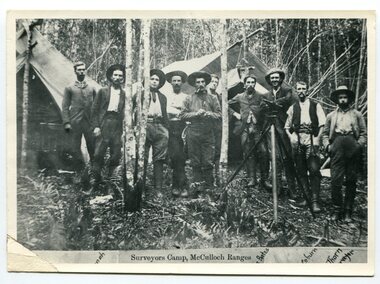
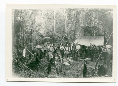
... The conditions they worked in were harsh and they embarked on journeys with drays carrying cumbersome surveying and camping equipment, spending months camping out in the bush and mapping the land. It was not until well into the second half of the nineteenth century that the professional training of surveyors became mandatory in Australia. ...The conditions they worked in were harsh and they embarked on journeys with drays carrying cumbersome surveying and camping equipment, spending months camping out in the bush and mapping the land. It was not until well into the second half of the nineteenth century that the professional training of surveyors became mandatory in Australia. ...This is a surveyors' camp in the McCulloch Ranges April, 1897. Surveyors were among the first European settlers to arrive in Australia. A Surveyor-General was present on the First Fleet, as well as the first two ships which landed in South Australia. These men were issued with instructions to record observations in a journal that included the country’s general appearance, its soil, flora and fauna and the customs and language of local inhabitants. The conditions they worked in were harsh and they embarked on journeys with drays carrying cumbersome surveying and camping equipment, spending months camping out in the bush and mapping the land. It was not until well into the second half of the nineteenth century that the professional training of surveyors became mandatory in Australia. This is a pictorial record of a surveyors' camp in the late 19th century.A black / white photograph of a group of men standing at a campsite in the bush. Two tents are in the background.on the front - "Surveyors Camp, McCulloch Ranges" Some names have been added for identification - Bates, Thorn and others which cannot be read.surveyors-camp-mcculloch-ranges land-settlement -
 Eltham District Historical Society Inc
Photograph, Louis Buvelot, Possibly Phillip Shillinglaw, 1865
... In the 1870s, his work increasingly drew elements from Australian landscape such as the bush land in works like Lilydale (1878) and Bush Track. ...In the 1870s, his work increasingly drew elements from Australian landscape such as the bush land in works like Lilydale (1878) and Bush Track. ...Famous Swiss landcape painter Louis Buvelot came to Melbourne in 1864 and set up a portrait photography studio which he operated for one year only in 1865. This photograph is believed to be the oldest photo in the Shillinglaw Family Album collection. It is believed that the subject is a young Phillip Shillinglaw, without beard, at age 22 or 23. Phillip Shillinglaw was born Melbourne, August 7, 1842. He married Sarah Ann Kidd in Heidelberg, Victoria, February 28, 1872. In 1881 Phillip and Sarah and their small family moved to Eltham and made home in what was later to become known as Shillinglaw Cottage but which Phillip named 'Wattle Brae'. Shillinglaw Cottage is significant to Eltham’s local history. It is one of the earliest known buildings still in existence. Records suggest that the cottage was built circa 1859 by a man named Cochrane, believed to be Thomas Cochrane, in conjunction with George Stebbings though it is not known what Stebbings’s contribution was. It is believed Stebbings owned the cottage between 1874 and 1888. According to Margaret Ball’s (2017) book Shillinglaw Family of Eltham 1660-2007, Thomas Cochrane and family lived there from 1867 to 1874 however this is contrary to the records of assessable rates levied by the Eltham District Road Board, established in 1858, which shows Cochrane was the owner occupier (in Little Eltham) of approximately 25 acres of cultivated land and 25 acres of pastureland upon which a hut was sited in 1860. It is suspected that George Stebbings may have acquired the property from Cochrane in 1874 as it is noted that he had a tenant for a period, James Rossiter, who was the editor for the Evelyn Observer in Kangaroo Ground in 1874 (LATE SHIRE OFFICE AT KANGAROO GROUND (1934, February 16). Advertiser (Hurstbridge, Vic. : 1922 - 1939), p. 5. Retrieved February 25, 2022, from http://nla.gov.au/nla.news-article56743657). In 1881 Phillip Shillinglaw became the ratepayer for the cottage though Stebbings retained ownership until 1888 at which time it was transferred to Shillinglaw. Photographer: Louis Buvelot Swiss landscape painter and portrait photographer, settled in Melbourne in 1864, admired by the artists from the Heidelberg area such as Tom Roberts and Arthur Streeton who bestowed him with the accolade of 'Father of Australian painting’. In the 1870s, his work increasingly drew elements from Australian landscape such as the bush land in works like Lilydale (1878) and Bush Track. "Louis Buvelot :: biography at :: at Design and Art Australia Online." Daao https://www.daao.org.au/bio/louis-buvelot/biography/. Accessed 9 Mar. 2023. On arriving in Melbourne in February 1865 Buvelot bought a photographer's studio at 92 Bourke Street East and took portraits for a year. In 1866 he moved to 88 La Trobe Street East and resumed his painting while Caroline-Julie gave French lessons to help Buvelot to establish himself as an artist in Melbourne. "Biography - Abram-Louis Buvelot." Australian Dictionary of Biography https://adb.anu.edu.au/biography/buvelot-abramlouis-3132. Accessed 2 Dec. 2022. CARTE-DE-VISITE (cdv) 1857-1890 Cartes-de-visite (cdv's) are the most common form of photograph from the nineteenth century, generally measuring two and a half inches by four and an eighth inches (6.3 x 10.5 cm) when mounted, sepia toned, mounted on a card which was generally printed with the photographer's name and address on the back or beneath the portrait. - Frost, Lenore; Dating Family Photos 1850-1920; Valiant Press Pty. Ltd., Berwick, Victoria 1991marg ball collection, shillinglaw family photo album 1, 1865, l. buvelot photographer, louis buvelot, phillip shillinglaw (1842-1914), unknown -
 Ringwood and District Historical Society
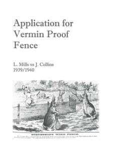
Document - Department of Lands and Survey, Wire Netting Branch, Melbourne, Victoria, Application for Vermin-Proof Fence Certificate - L.J. Mills vs John Collins, Grandview Grove, Ringwood, Victoria - 1939
... Cleared grass land adjoins the south boundary and bush land adjoins the north and west boundaries. ...Cleared grass land adjoins the south boundary and bush land adjoins the north and west boundaries. ...Photocopied file of corresponence and documentation relating to a claim by L.J. Mills, Nurseryman, that adjoining property owner, J. Collins, Farmer, assists with replacement of a vermin proof wire netting dividing fence destroyed by 1939 bushfire. File includes 1939 and 1940 detailed property inspection reports by Vermin and Noxious Weeds Branch, Lands Department, Lilydale, describing land use in the area and signs of vermin activity. Application approved 18th April, 1940. Appeal lodged by Mr Collins disallowed in May, 1940. File closed June, 1940 with Departmental suggesion that Mr Mills consider further legal action through a Solicitor as fence had still not been wire-netted. TRANSCRIPTS: Vermin & Noxious Weeds Inspection Reports "19/9/1939 (To) Superintendent (Department of Lands and Survey, Melbourne) Re L.J. Mills application for Vermin Proof Fence. I called on Mr Mills yesterday 18th instant in connection with this matter. Mr Mills has a flower farm and claims that rabbits and hares are damaging his flowers. He showed me a bed of carnations which he stated were being damaged by rabbits. There was evidence of some leaves being nipped off, but I am unable to say whether this is due to rabbits or grubs. Very little if any real damage is being done. The property is netted on the east and south boundary and on half the north and west boundary. The surrounding country is undlating and fairly steep in places. The land to the east across Grandview Avenue (sic) is all planted out in old established orchards and well cultivated. Cleared grass land adjoins the south boundary and bush land adjoins the north and west boundaries. I walked over a large area surrounding Mr Mills land and never saw any rabbits or hares or any indications of rabbits. This locality is not rabbit infested and very little wire netting is being used. I do not consider that a vermin proof fence is necessary between these allotments. - Jas H Allison (Inspector, Vermin and Noxious Weeds Branch, Lands Department, Lilydale)." Follow up report following renewal of application for Certificate by Mr Mills, citing rabbits causing considerable damage to his flowers. He laid poison and obtained 9 carcases and stated that there is evidence of rabbit infestation from the adjoing land. "19/3/1940 (To) Mr Hannah (Superintendant, Department of Lands and Survey, Melbourne) Re L.J. Mills, Grandview Grove Ringwood, Lot 4 Grandview Estate Pt CG20 Ph of Warrandyte. I interviewed Mr Mills at his home on 15th inst. He showed me carcases of rabbits which he stated had been poisoned on his land. In places young plants had been nipped off apparently by rabbits. I made an inspection of adjoining properties and found one live burrow close to Mr Mills northern boundary. There were scratches and other evidence of rabbits on land north and west of Mr Mills property. In view of the present evidence of rabbits I consider that a vermin proof fence is now necessary to protect the flowers grown by Mr Mills. His land is netted on whole of east and south boundary and half way on west and north boundary. The adjoining land on west and north boundaries is owned by Mrs Linda Collins and John Collins resp of Brysons Road East Ringwood. - Jas H Allison (Inspector, Vermin and Noxious Weeds Branch, Lands Department, Lilydale)." -
 Orbost & District Historical Society
black / white photograph, 1897
... The conditions they worked in were harsh and they embarked on journeys with drays carrying cumbersome surveying and camping equipment, spending months camping out in the bush and mapping the land. It was not until well into the second half of the nineteenth century that the professional training of surveyors became mandatory in Australia....The conditions they worked in were harsh and they embarked on journeys with drays carrying cumbersome surveying and camping equipment, spending months camping out in the bush and mapping the land. It was not until well into the second half of the nineteenth century that the professional training of surveyors became mandatory in Australia. ...Link with item 1178. This is a surveyors' camp in the McCulloch Ranges, Murrangowar, April, 1897. Included in the photograph are: L. Thorn; Pearson; L. Coburn, Clem Bates; Sam Blacklock with a packhorse. They were surveying for a road or railway. Surveyors were among the first European settlers to arrive in Australia. A Surveyor-General was present on the First Fleet, as well as the first two ships which landed in South Australia. These men were issued with instructions to record observations in a journal that included the country’s general appearance, its soil, flora and fauna and the customs and language of local inhabitants. The conditions they worked in were harsh and they embarked on journeys with drays carrying cumbersome surveying and camping equipment, spending months camping out in the bush and mapping the land. It was not until well into the second half of the nineteenth century that the professional training of surveyors became mandatory in Australia.This is a pictorial record of a surveyors' camp in the late 19th century.A black / white photograph of a group of men standing in front of a tent / camp in a dense bush setting.surveyor's-camp-mccullochs-ranges-murrangowar land-settlement -
 Kiewa Valley Historical Society
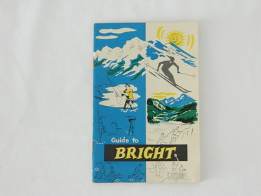
Pamphlet - Bright Tourism, Guide to Bright and District, late 1900s
... Some of the regions unique facilities and geological structures are well suited to those tourists who live in cities and "flat land" regional bush areas within Australia. This was a period when the average Australian domestic tourist was more able (finance and transport wise) to see more of their country within the short time they had for "holidays". ...Some of the regions unique facilities and geological structures are well suited to those tourists who live in cities and "flat land" regional bush areas within Australia. This was a period when the average Australian domestic tourist was more able (finance and transport wise) to see more of their country within the short time they had for "holidays". ...This publication was produced in the early 1950s to provide the growing tourism trade (at this time), to the region with a more detailed overview of the facilities available to tourists of the region's attractions. This brochure is a very efficient and effective promotional publication. The increasing level of self promotion by local business and commerce sectors of the region the more sought after the region became and the greater the ability of the region to grow (non rural based economy). Some of the regions unique facilities and geological structures are well suited to those tourists who live in cities and "flat land" regional bush areas within Australia. This was a period when the average Australian domestic tourist was more able (finance and transport wise) to see more of their country within the short time they had for "holidays". In the late 1900s, however, with the increase to workers' recreational leave and better transportation (fares, ease of travel to overseas destinations) the local tourism numbers from other domestic locations have been steadily declining. From the 1970s onwards, the increased tourism demand from overseas tourists, for better facilities and easier access to these regional facilities, resulted in better transport, accommodation and communication, which has been a boon for all tourism within Australia. In the 21st century the world is becoming smaller and smaller for the international tourist, especially for those from crowded Asian cities. The greater attraction for "open" spaced locations such as this region are becoming a much sought after change of scenery. This pamphlet which targets the tourist, whether either from other Australian regions or the global tourist, is a good example of self promotion by a relatively small local population. This is especially significant because before the "tourist explosion" in the 1950s onward, these regional areas had a more introspective society with greater emphasis to locally established mores and values. The increased interactions with people from other areas and nations, combined with a greater global communication network is affecting those traditionally established mores to produce a some what unique social transformation which is constantly changing from one generation to the next. One important factor which tourism does bring is that it opens up the region to a wider range of people who look to the region for their own lifestyle changes.This pamphlet has a front cover in colour with the major activities in the region sketched depicting : sunshine, snow skiing, trout fishing, mountain climbing, golfing, swimming, alpine views, tennis, lawn bowls and picnics. The back cover is blank. The pamphlet is fastened together by two staples 30mm from top and bottom, and is folded with the cover slightly thicker than the fifteen pages. Thirteen pages have been printed on both sides. The first page has a black and white photograph of the hotel Alpine and the tall brick constructed Clock Tower. There are another five black and white photographs in the pamphlet.on front cover "Guide to BRIGHT"local tourism, regional information booklet, "time" related brochures, alpine local history -
 Kiewa Valley Historical Society
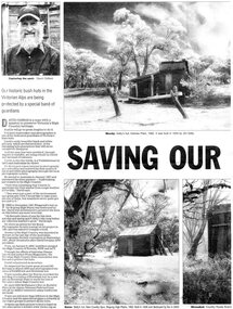
Newspaper article- Double page article. Pages 30 & 83 from the Herald Sun Newspaper. February 18, 2006 regarding preserving Victoria’s High Country Huts
... land in the valleys for pastoral uses and the displacement the original inhabitants in the high country which became a boon for cattlemen due to extensive lush summer grazing for cattle. High country cattlemen built a variety of huts for shelter and storage, when driving cattle up to the plains in summer, during mustering and bringing the cattle down from the mountains before winter closed in. These same huts now provide shelter from the elements for hikers, bush...land in the valleys for pastoral uses and the displacement the original inhabitants in the high country which became a boon for cattlemen due to extensive lush summer grazing for cattle. High country cattlemen built a variety of huts for shelter and storage, when driving cattle up to the plains in summer, during mustering and bringing the cattle down from the mountains before winter closed in. These same huts now provide shelter from the elements for hikers, bush ...The arrival of explorers Hume & Hovell in 1842 brought about the widespread clearing of land in the valleys for pastoral uses and the displacement the original inhabitants in the high country which became a boon for cattlemen due to extensive lush summer grazing for cattle. High country cattlemen built a variety of huts for shelter and storage, when driving cattle up to the plains in summer, during mustering and bringing the cattle down from the mountains before winter closed in. These same huts now provide shelter from the elements for hikers, bush walkers and skiers. Wallace’s Hut is the oldest of the Cattleman’s huts still standing in the Alpine National Park and is classified under the National Trust. Due to their age and the ravages of the elements, including bush fires, many of the huts have been destroyed, or are falling into disrepair. Groups of willing volunteers are now working to preserve as many of the huts as possible with restoration or rebuilding.The numerous cattleman’s huts of the Alpine National Park and the colourful characters who erected them represent a significant part of the history of the high country area and early cattle grazing, which has been the theme for many poets and film-makers alike. They also have a significant role in the early days of the SECV when they were used by surveyors and other workers for shelter and temporary accommodation. More recently the huts have functioned as shelter for hikers and skiers caught out in the elements and a refuge along the long trek for bush walkers. They are a popular attraction for tourists and feature prominently in much of the tourist information of the region. Black and white double page Newspaper article from the Herald Sun Newspaper of February 18, 2006 regarding the efforts of Mr David Oldfield to preserve Victoria’s remaining High Country Huts through his photography and efforts to restore old and Re-build missing ones. Article shows a photograph of David Oldfield and some of his photographic work of the huts. Page number and date printed at top of each page 30 Herald Sun, Saturday, February 18, 2006 Herald Sun, Saturday, February 18, 2006 83 cattlemen's huts; david oldfield; bogong high plains; wallace's hut; high country; alpine national park -
 Kiewa Valley Historical Society
Photograph - 30 black and white photographs (assorted sizes) plus page from a newspaper and copied article on A4 paper, c1880's c1910 - 1920 (photographs) Newspaper 1961
... land clearing for farming. The photos of Mt. Buffalo Chalet have social, architectural and historical significance. the Chalet has been used by skiers, bush walkers and day trippers since its completion in 1910 and its closure in 2006. ...K2,3 and4 are of the Kiewa River and two of the bridges spanning the river along the valley. K3 and K4 would have been taken in the 1880's and show the type of trees and plant growth along the river prior to land clearing for farming. K5 is of the Running Creek Cricket Team and therefore there was sufficient population in the area to form and maintain a team as well as have other teams in the relatively near vicinity to provide competition. Note the horse drawn cart which provided transport. Date taken is unknown but possibly c 1910. The Mt. Buffalo Chalet was built in 1910 by the Victorian Government. It was Australia's first ski resort and has served generations of skiiers, hikers and families over the years. It was built for 3195 pounds and has had stories and wings added since and is the largest timber building in Australia. B4 is the earliest photo in this group as the garden is in early stages of development - the other photos show the growth of the shrubs and would be taken about c 1920. Note the cars and motor bikes. It closed in 2006. The other photos are of general interest only but interesting to see that there were donkey's grazing. There is no information as to their purpose on Mt. Buffalo. Four different Kiewa Valley families are represented in the photographs. Their descendants still live in the Valley and carry on the traditions of beef and dairy farming. Of particular interest is the photo of Miss Marjorie Clemence, the first School Teacher of Upper Gundowring School. Gundowring pastoral run was taken up in 1838 and occupied by framers in the 1860's. The area was known as Gundowring and Upper Gundowring. The Gundowring School was opened in 1871 and most likely the Upper Gundowring school would be built at the same time. It was School No. 2733 and situated in Boyd Road. It closed in 1953 when the Kiewa Consolidated School opened. The newspaper page describes the activities in which the local community of Kergunyah were in engaged in that period - Red Cross, Fire Brigade, cattle round up and some of the identities involved. The article photocopied from the Yackandandah times states that he (Norman Coad) "was sent to the Ovens District Hospital, Beechworth for treatment" which would mean that this was the closest hospital to the Kiewa Valley for emergencies in 1912.The Kiewa Valley photographs are of social significance showing two of the early bridges allowing the community easy access to both sides of the river and also the tree and plant growth before land clearing for farming. The photos of Mt. Buffalo Chalet have social, architectural and historical significance. the Chalet has been used by skiers, bush walkers and day trippers since its completion in 1910 and its closure in 2006. It is listed in the Victorian Heritage Register. The family photographs are of social and historical significance as they are of early farming families in the Kiewa Valley and also depict the dress, of both men and women) in the late 1880's. The write up in the Weekly Times has social significance as it depicts the social and farming activities and photos of the local residents from around that area. The article from the Yackandandah Times is of a personal nature with concern for the individual involved. Note: There is a photo of the gentleman mentioned in the article (Mr. Norman Coad) in the Families of the Kiewa Valley (F4) as above.30 black and white photographs - 5 of the Kiewa Valley, 8 of families of the Kiewa Vallley and 17 of Mt. Buffalo. Various sized photos. Page from the Weekly times and copied article from the Yackandandah Times on A4 sheet.(Note for easier identification they have been numbered and grouped - K1-5 (Kiewa Valley), F1-8 (Families) and B1-17 (Mt. Buffalo). K1: handwritten in ink, lower L hand corner "Bogong in the distance". K2: handwritten in ink lower L hand corner "Mongan's Bridge or Towonga". K3 handwritten in ink "Taken from Mongan Bridge looking up stream". K4 - no inscription. K5: handwritten in ink, back of photo "Running Creek Cricket Team". F1: handwritten in ink on back "Mrs. Heap" and lower down in pencil "1880's". F2 handwritten in pencil at top of back phot "Land at Tawonga TROVE The Y'dah Times 20/2/1913" and lower down in ink "Henry Ellis Larkin". F3: handwritten in ink bottom edge "Mrs Coad". Note that this photo is a postcard. F4: Written in ink lower edge "Norman Coad". Note this photo is also a postcard. F5: Lower left corner in Ink "Harry Larkin". F6: lower half back of photo, in ink "Bernie Maddison". F7: on back of photograph in ink "Miss Marjorie Clemence first School Teacher Upper Gundowring: and underneath, in pencil "C1880's". F8: Handwritten in ink on back of photo "Frank & Mrs. Keat & Lesley of Tawonga". Lower down in pencil "c1912-1914". B1: Back of photo in ink "The Chalet Mt. Buffalo". B2: no inscription. B3: "chalet at Bufflo" in ink lower left corner. B4: This is a post card. Written in ink is "Mt. Buffalo Chalet". B5 - B10 printed in ink, lower left corner "Buffalo". B11: no inscription. B12: "Mt. Buffalo" lower R corner. B13: "Buffalo?". B15: Printed in ink lower edge "Picnic at Buffalo". B16: "Donkeys on Mt. Buffalo" printed in ink lower edge. B17: handwritten in ink across back of photo "Donkeys & top of Mt. Buffalo with the Monileith in the distance". A4 sheet of paper describing an accident to Mr. Norman Coad. Under article is : Yackandandah Times (Vic: 1890 - 1931), Thursday 18 July 1912, page 3. A page torn from the Weekly Times, June 14, 1961 and entitled "Kergunyah has picturesque setting". kiewa valley, farming, families, kergunyah, gundowring upper, mt. buffalo chalet, briggs family, larki family, coad family, clemence family, laskowski collection -
 Kiewa Valley Historical Society
Papers - Mt Beauty Airport Development
... land was officially opened as an Airport as an official tourist activity in 1977. It continues to be available to tourists, fire fighters, the air ambulance and the local gliding club. The opening of Mt Beauty Airport has enhanced Mt Beauty township by enabling fire fighters to access the surrounding bush during bush fires, by enabling Ambulance helicopters to rush emergency patients to city hospital, by giving tourists the opportunity to fly in and to give the local Gliding Club the opportunity to store and fly their gliders. mt beauty airport history alex mccullough transport tourism 1. ...The SECV began investigating four possible sites for an airstrip in Mt Beauty in 1965. The land was owned by the SEC and leased by Mr J. Sharp. It became available on the condition that the land would only be available to the Municipal shire. This land was officially opened as an Airport as an official tourist activity in 1977. It continues to be available to tourists, fire fighters, the air ambulance and the local gliding club.The opening of Mt Beauty Airport has enhanced Mt Beauty township by enabling fire fighters to access the surrounding bush during bush fires, by enabling Ambulance helicopters to rush emergency patients to city hospital, by giving tourists the opportunity to fly in and to give the local Gliding Club the opportunity to store and fly their gliders. 1. Set of papers titled 'History Mt Beauty Airport Development' held together by large steel clip by Alex McCullough. 2. Set of papers titled 'Department of Transport' and 'Alpine Shire' both held together by one staple. 3.Mt Beauty Township Survey Plan of Airstrip 1975 4. Large folder titled Mr J. R. Sharp 1975 - Mt Beauty Airfieldmt beauty airport history, alex mccullough, transport, tourism -
 Bendigo Military Museum
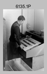
Photograph - Print Troop – Lithographic Squadron – Army Survey Regiment, Fortuna, Bendigo
... land in survival situations. The authoritative information was provided by Major Leslie James (Les) Hiddins aka ‘the Bush Tucker Man’ He is a retired Australian Army soldier and war veteran, who is best known for his love and knowledge of the Australian bush. ...land in survival situations. The authoritative information was provided by Major Leslie James (Les) Hiddins aka ‘the Bush Tucker Man’ He is a retired Australian Army soldier and war veteran, who is best known for his love and knowledge of the Australian bush. ...This collection of 23 photos was most likely taken in Lithographic Squadron, Army Survey Regiment, Fortuna, Bendigo, in 1988. In photos .1P and .2P the technician is preparing a Chromalin map proof for supporting information that would be printed on the reverse side of a topographic map. This map was commonly referred to as a ‘snack’ map, with photos of edible indigenous plants and descriptions endemic to that region printed on the reverse side to assist soldiers living off the land in survival situations. The authoritative information was provided by Major Leslie James (Les) Hiddins aka ‘the Bush Tucker Man’ He is a retired Australian Army soldier and war veteran, who is best known for his love and knowledge of the Australian bush. See item 6190.6P for more information on the Chomalin proof production process. In the remaining photos, Print Troop’s technicians were most likely operating the Komoni, Planeta or Ultra-MAN-III offset printing presses, as well as working in the map despatch dock. Although these photos are not annotated most personnel are positively identified. This is a set of 23 photographs of Print Troop personnel and equipment from Lithographic Squadron at the Army Survey Regiment, Fortuna, Bendigo, 1988. The photographs were on 35mm negative film and were scanned at 96 dpi. They are part of the Army Survey Regiment’s Collection. .1) - Photo, black & white, 1988, Chromalin Proof laminating, Terry King. .2) - Photo, black & white, 1988, Chromalin Proof laminating, Terry King. .3) to .6) - Photo, black & white, 1988, Ultra-MAN-III Printing Press, Colin Yeats. .7) - Photo, black & white, 1988, Ultra-MAN-III Printing Press, L to R: Greg Rowe, SPR Mark ‘Dogs’ Doherty. .8) - Photo, black & white, 1988, Ultra-MAN-III Printing Press, SPR Mark ‘Dogs’ Doherty. .9) to .10) - Photo, black & white, 1988, Ultra-MAN-III Printing Press, John Bateman. .11) - Photo, black & white, 1988, Ultra-MAN-III Printing Press. .12) - Photo, black & white, 1988, Map laminator? L to R: SGT Dale Hudson, SGT Gary Kerr. .13) - Photo, black & white, 1988, Newkoni Komori Printing Press, Peter Hamilton. .14) to .17) - Photo, black & white, 1988, Original Heidelberg Printing Press, Peter Hamilton. .18) to .19) - Photo, black & white, 1988, Map Despatch area, SPR Steve Wright. .20) - Photo, black & white, 1988, Map Despatch area, L to R: unidentified, SGT Gary Kerr. .21) - Photo, black & white, 1988, Printing Presses - foreground: Ultra-MAN-III (x2), centre: Newkoni Komori and background: Planeta Polygraph. .22) - Photo, black & white, 1988, Ultra-MAN-III Printing Presses (x2). .23) - Photo, black & white, 1988, L to R: Daryl South, Mark McCulloch.No personnel are identifiedroyal australian survey corps, rasvy, army survey regiment, army svy regt, fortuna, asr, litho, printing -
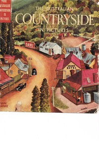 Kiewa Valley Historical Society
Book - Reference Countryside, The Australian Countryside in Pictures, circa 1950s
... land...swag-man of the bush...This unity within the rural environment is something that is attracting more and more families from sometimes alienating city life. country life australian "outback" rural industries life on the land swag-man of the bush On the tittle page is a signature "C Roper" This printed coloured sketched, or painted paper sleeve of the book is freely wrapped over a dark red hard cover. ...This book is a "snapshot" in time (1950s) detailing life in Australia covering a time when a "man's word and handshake" were his moral and quasi legal bond, and the now relative defunct saying "smoko" (having a "time out" from work for a cigarette and tea or coffee). The book spans an era where the male was still the "head" of the family even though for a majority of families the women took on the many "male only" roles during the World War II period. This shift in the leadership of the family hierarchy is mentioned, so ever slightly, (not to offend the still predominant macho male image) in both rural and city environments. The effects of the war, and later the push for women's emancipation and equality in both family, social, workplace and political areas of life, since this book was published, is now finally resolved. However there are still some sections of the recent migrate population where this male dominance is causing a few problems.The significance of this book is not only because it was donated by Mrs C. Roper ( from the Roper Family, a pioneer Kiewa Valley and surrounding Region family - originally beef cattle graziers) but also a Kiewa Valley resident and family, experiencing the shift in the social and economical life of post World War II rural Australia. The strong heritage link to this region of many families still residing within its boundaries, is a clear affirmation of the bond that the Kiewa Valley and its Regions have upon family unity. This unity within the rural environment is something that is attracting more and more families from sometimes alienating city life.This printed coloured sketched, or painted paper sleeve of the book is freely wrapped over a dark red hard cover. Into the front of the cover is pressed a standing pose of a farmer with long sleeves rolled up over his elbows. Behind him and to the right are what appears to be three sacks of wheat and next to him is a merino sheep. To the left and down are two dogs one with a fox in its jaws. The book contains 240 pages, 300 illustrations in gravure and 25 pictures in full colour. The inside fly leaf is a colour photograph of a rural scene with dirt road running in the centre and to the left a farm house and a five bay open storage barnOn the tittle page is a signature "C Roper"country life, australian "outback", rural industries, life on the land, swag-man of the bush -
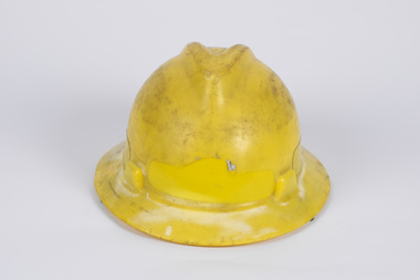
Emerald Museum & Nobelius Heritage Park
Headwear - Fire Fighters Helmet, MSA, c.1970s
... Bush Brigade. Originally its equipment was stored at Madigan's butcher's shop near the corner of Monbulk Road. The Brigade's first fire station was built around 1945. In 1966, this station was recorded as containing the fire truck and a Land...Bush Brigade. Originally its equipment was stored at Madigan's butcher's shop near the corner of Monbulk Road. The Brigade's first fire station was built around 1945. In 1966, this station was recorded as containing the fire truck and a Land ...Helmets protect firefighters from heat, falling objects and cinders. During the 1960s in Australia, helmets evolved from metal construction to that of polymer and other plastics. The manufacturer of this helmet, MSA, was founded in 1914 in the USA. It began as a mine safety company but since expanded into more general worker protection and safety products. The Emerald Fire Brigade was established on 14 March 1941 as the Emerald Bush Brigade. Originally its equipment was stored at Madigan's butcher's shop near the corner of Monbulk Road. The Brigade's first fire station was built around 1945. In 1966, this station was recorded as containing the fire truck and a Land rover pumper, three radio sets, 40 knapsacks, six lengths of hose, helmets, rake hoes and other hand tools. In 2010, the Brigade moved into a new purpose-built building in Monbulk Road.This helmet is an historical artifact worn by members of a crucial volunteer fire fighting service operating in the Emerald district since 1941.Yellow, lightweight, hard plastic or polymer helmet with black leather detachable chin strap with velcro fastening.Inside helmet on a partly torn label: 'MSA / VGARD / Type 2 ...? / STANDARDS AUSTRALIA' Inside the brim at one end engraved: 'MSA'' and at the other end: '1801-1881 / LN70' On front of helmet a label with logo and red lettering: 'CFA' helmets, fire fighting, msa, emerald fire brigade, cfa -
 Emerald Museum & Nobelius Heritage Park
Headwear - Fire Fighters Helmet, MSA, c.1970s
... Bush Brigade. Originally its equipment was stored at Madigan's butcher's shop near the corner of Monbulk Road. The Brigade's first fire station was built around 1945. In 1966, this station was recorded as containing the fire truck and a Land...Bush Brigade. Originally its equipment was stored at Madigan's butcher's shop near the corner of Monbulk Road. The Brigade's first fire station was built around 1945. In 1966, this station was recorded as containing the fire truck and a Land ...During the 1960s in Australia, helmets evolved from metal construction to that of polymer and other plastics. This helmet was donated by the Emerald Fire Brigade which was established on 14 March 1941 as the Emerald Bush Brigade. Originally its equipment was stored at Madigan's butcher's shop near the corner of Monbulk Road. The Brigade's first fire station was built around 1945. In 1966, this station was recorded as containing the fire truck and a Land rover pumper, three radio sets, 40 knapsacks, six lengths of hose, helmets, rake hoes and other hand tools. In 2010, the Brigade moved into a new purpose-built building in Monbulk Road. The manufacturer of this helmet, MSA, was founded in 1914 in the USA. MSA began as a mine safety company but since expanded into more general worker protection and safety products. This helmet is an historical artifact worn by members of a crucial volunteer fire fighting service operating in the Emerald district since 1941.Yellow, lightweight, hard plastic or polymer helmet with black leather detachable chin strap with Velcro fastening. inside the helmet is an adjustable head harnessInside helmet on a partly torn label: 'MSA / VGARD / Type 2 ...? / STANDARDS AUSTRALIA' Inside the brim black pen writing EMERALD SPARE 5 EMERALD at one end engraved: 'MSA'' and at the other end: '1801-1881 On the outside of the helmet there is a yellow reflector on each side and at the front and the back there is evidence of labels that have been removed.helmets, fire fighting, msa, emerald fire brigade, cfa -
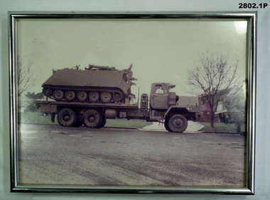 Bendigo Military Museum
Photograph - PHOTOGRAPH, FRAMED & PHOTOGRAPHS, post 1970
... .1) Framed coloured photo of tray truck with personal carrier aboard, silver metal frame with glass front & khaki hanging cord. .2) Coloured photo of recovery vehicle towing a troop carrier vehicle. .3) Coloured photo of army vehicle No 12 in bush setting. .4) Coloured photo of land rover under camouflage net in bush setting....Bendigo Military Museum 37 - 39 Pall Mall Bendigo goldfields photography-photographs frame accessories military history Passchendaele barracks trust .1) On stickers on back of frame: "Sgt Jones - APC Lift 9-10-11 Sep - 1984 - Cobram - Hay - 468 klms Trust No 5" .1) Framed coloured photo of tray truck with personal carrier aboard, silver metal frame with glass front & khaki hanging cord. .2) Coloured photo of recovery vehicle towing a troop carrier vehicle. .3) Coloured photo of army vehicle No 12 in bush setting. .4) Coloured photo of land rover under camouflage net in bush setting. ....1) Framed coloured photo of tray truck with personal carrier aboard, silver metal frame with glass front & khaki hanging cord. .2) Coloured photo of recovery vehicle towing a troop carrier vehicle. .3) Coloured photo of army vehicle No 12 in bush setting. .4) Coloured photo of land rover under camouflage net in bush setting..1) On stickers on back of frame: "Sgt Jones - APC Lift 9-10-11 Sep - 1984 - Cobram - Hay - 468 klms Trust No 5"photography-photographs, frame accessories, military history, passchendaele barracks trust