Showing 250 items matching caravan park
-
 Stawell Historical Society Inc
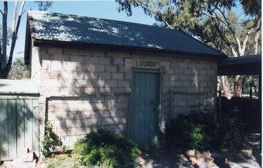
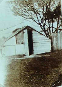
Photograph, Grampians Gate Caravan Park -- Laundry built 1951 -- photo taken 2000
... Grampians Gate Caravan Park -- Laundry built 1951 -- photo...Grampians Gate Caravan Park. Laundry built 1951 photo...Grampians Gate Caravan Park. Laundry built 1951 photo taken ...Grampians Gate Caravan Park. Laundry built 1951 photo taken 2000stawell -
 Clunes Museum
LETTER, 1971
... caravan park... on the current situation with the proposed caravan park for Clunes...., (TYPED) TO SECRETARY OF CARAVAN PARK AND SCENIC ROAD COMMITTEE...) TO SECRETARY OF CARAVAN PARK AND SCENIC ROAD COMMITTEE OF CLUNES. DATED ...Correspondence from the Shire to the Committee on the current situation with the proposed caravan park for Clunes.CARBON COPY CORRESPONDENCE FROM SHIRE OF TALBOT & CLUNES, (TYPED) TO SECRETARY OF CARAVAN PARK AND SCENIC ROAD COMMITTEE OF CLUNES. DATED 6TH APRIL, 1971local history, document, letter, caravan park -
 Stawell Historical Society Inc
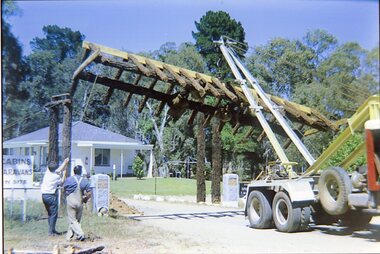
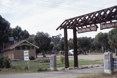
Photograph, Grampians Gate Caravan Park -- Contruction of the park entrance -- Coloured
... Grampians Gate Caravan Park -- Contruction of the park...Grampians Gate Caravan Park. Timber structure being... grampians Photograph Grampians Gate Caravan Park -- Contruction ...Grampians Gate Caravan Park. Timber structure being lowered into place over park entrance.stawell -
 Port of Echuca
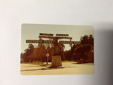
Colour Photograph, Approx.1979
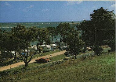
... Echuca council caravan park... Council caravan park. The signage in this photograph is no longer... are shown, to the east "Caravan Park" and to the west , "Victoria... are shown, to the east "Caravan Park" and to the west , "Victoria ...In 1869 the Council moved to name this park "Victoria Park. The cricket pitch construction began in 1873 and major improvements to the ground were undertaken in 1881. It is still the primary sporting ground in Echuca, offering AFL football oval, cricket pitch and nets, athletics and entry to the Echuca boat ramp and the natural bush land of the scenic drive. It also houses Echuca Council caravan park. The signage in this photograph is no longer there and the enterance to the caravan park has moved.This area of Echuca has historically been a major recreational area for the town. Being the primary sporting ground since its establishment in 1869., the area has a number of sporting and recreational facilities for the people of Campaspe Shire, from natural bush walks in and along the Murray river to more formal facilities such as AFL football ground, firefighting training area, netball courts, cricket pitch and nets, and grass tennis courts. Colour photograph (post-card size) of directory signs to entrance of Victoria Park, Echuca taken facing north. Two driveways are shown, to the east "Caravan Park" and to the west , "Victoria Park", "Boat ramp", " Scenic drive"Printed in black on the reverse:"this paper manufactured by Kodak"echuca, port of, echuca council caravan park, victoria park, echuca, echuca-tourist attraction -
 Phillip Island and District Historical Society Inc.
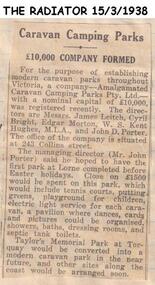
Newspaper clippings
... Caravan Parks in Victoria, called Amalgamated Caravan Parks Pty...Article on establishment of Caravan Parks Company.... on establishment of Caravan Parks Company. Article on establishment ...Article on establishment of Company to establish modern Caravan Parks in Victoria, called Amalgamated Caravan Parks Pty Ltd, first Park to be at Lorne. Includes description of intended facilities. A second park to be established at Torquay.Article on establishment of Caravan Parks Company.local history, documents, newspapers, caravan parks, black & white newspaper clipping -
 Eltham District Historical Society Inc
Photograph, Hume and Hovell Monument, Honeysuckle Caravan Park, Violet Town (28.12.1824), Spring Excursion, Hume and Hovell's 1824 expedition (Part 2), 26 October 1997, 26/10/1997
... Hume and Hovell Monument, Honeysuckle Caravan Park, Violet... at the entrance to Honey Suckle Creek Caravan Park, Violet Town... at the entrance to Honey Suckle Creek Caravan Park, Violet Town ...[article by Diana Bassett-Smith in EDHS Newsletter No. 117, November 1997:] MONUMENT HUNTING THE HUME AND HOVELL WAY - Sunday October 26 1997 dawned bright and very warm. Some twenty-five members, complete with picnic baskets, met outside the Eltham Library awaiting the Cobb and Co. large coach which would be taking us on the second leg of our travels along the route of the early explorers Hume and Hovell. Stephen West was our very good driver for the day. He would be guided around the circuitous route by Russell Yeoman who had made a detailed study, not only of the intended route, but of the story of these two explorers. During the trip Russell regaled us with poetry, quotations from the Journals and the History of the Shire of Seymour, "The New Crossing Place" by Martindale, 1982, (now Mitchell Shire due to the recent amalgamations). We headed towards the Hume Highway via Greensborough and Cooper Street and proceeded north to our first stop, noting on the way Monument Hill in the distance which is near Kilmore and, according to Russell, well worth the effort to visit as the view across the valley is magnificent. Past Sunday Creek Valley, Mt Piper and Mt Disappointment, all traversed and noted and named by them. We passed through Tallarook, then onto Seymour where we took photos of the monument telling us that Hume and Hovell had passed through on the 28th of October 1824. We also deviated down Hume and Hovell Road viewing deer and emu farming and the Bellbourie property now a sanctuary. Leaving Seymour behind we travelled up the Avenel Road to the Avenel monument, pyramidal in design of four reducing square blocks with a sharply pointed peak, erected in 1924 in memory of the 1824 exploration. The day was warming up and the countryside showing the dryness of the current drought. A parallel note had been made in their journal too of 1824 of the drought appearance of the country they were traversing. At Seven Creeks, Euroa we stopped for some minutes to check the monument placed 20th November 1924 to commemorate their passage on the 29th December 1824. More photos. Russell had pointed out the abrupt termination of the distant ranges which is noted in their journal. The next monument is beside the road at the entrance to Honey Suckle Creek Caravan Park, Violet Town. The squarish shaped monument some eight feet high is topped with a simple steel cross, and was to mark the date of 28th December 1824 and built for the 20th November 1924. By now it was 12.20 and nearly lunchtime as we drove along the Warranbayne Road to Roach's Road, monument hunting without success. Though there is a large, what appears to be an old timber sign which was hard to read, maybe this was the lost monument. In many of the paddocks hay had been cut and baled or was being cut, what a contrast to the rugged country they had passed through which was smoky from the fires of the natives burning off. By 1.00 pm we were at Benalla and pulled up beside the park where abundant beds of roses filled the air with their scent and the smell of barbecued food twitched the nostrils whilst the cheerful sounds of other picnickers could be heard throughout the park. We left the bus and collected up our picnics, dispersed to the various tables and enjoyed the shade from the various European trees. 2.00 pm and we were on the road again driving along the Benalla, Mansfield, Yea road. The Swanpool monument states that they passed four miles south and returned three miles north. Then we stopped at the Barjarg monument which notes that they camped near this spot. It is again a pyramidal monument and this time topped with a steel arrow indicating their route of the 29th November 1824. Half an hour later we came to another monument, again with a steel arrow marker on top and the plaque dated the 2nd of 12th 1824. Erected on the 12th of 12th 1924. "They blazed the way that we might inherit the land." Another square based and needle topped monument appeared at Yarck near Yea and this plaque records the date of 3 December 1824. Near McGuigans Road Russell related that the expedition had lost a dog but it had found them next day, the dog was apparently torn by a kangaroo. A short while later Russell reminded us here of the problems they encountered in crossing the Goulburn River near Molesworth where banks were high, water deep and wide. "Good coat of grass but quite dry due to drought". At Yea we stopped for afternoon tea and raided the last of our picnics and looked at the monument to their journey of 1824, situated at a corner of the gardens near the bowling green. No photo – we were out of film. We returned home via Kinglake West and Whittlesea past the Yan Yean Reservoir, not full. 5.00 pm back at Eltham we emptied out of the bus and everyone, including Joan Cole, collected their things, Joan also had the major souvenir of the day, a large carp she had picked up from the river bank, her cat was in for a great feast. The day was made so interesting by the informed commentary which Russell provided. His background knowledge of the route and nature of the journey could only have come from many hours of reading and driving the area. Thank you to Russell and to everyone who made the day so informative and pleasurable. Colour photographactivities, hume and hovell, monument, violet town -
 Inverloch Historical Society
Postcard, Caravan Park & Anderson Inlet - Rose Series Colorview no 1548
... Caravan Park & Anderson Inlet - Rose Series Colorview no...) Inverloch gippsland Postcard Caravan Park & Anderson Inlet - Rose ... -
 Inverloch Historical Society
000544 - Photograph - Whiter's Caravan Park before 2nd War - C Newton
... 000544 - Photograph - Whiter's Caravan Park before 2nd War...) Inverloch gippsland 000544 - Photograph - Whiter's Caravan Park ... -
 Inverloch Historical Society
000964 - Photograph - Inverloch - George Treadwell seated at caravan park - from Isobel Treadwell
... at caravan park - from Isobel Treadwell... Treadwell seated at caravan park - from Isobel Treadwell ... -
 Kiewa Valley Historical Society
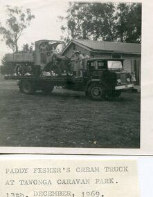
Photo - Paddy Fisher's Cream Truck 1969, December 13, 1969
... loaded onto a tray truck at the Tawonga Caravan Park. Seven... cream truck at Tawonga caravan park. 13th December, 1969... at the Tawonga Caravan Park. Seven unidentified people on the tray truck ...The Hallford truck was made by J & E Hall, of Dartford, England, whose business commenced in 1785. In 1926 the Fisher family of Mongan's Bridge took delivery of the 1923 Hallford truck which was used on the farm to transport cream to the Kiewa Butter Factory in Tangambalanga. In 1967, the truck was sold to Mr Greg Bedstead and other members of the Kiewa Valley Historical Society for the KVHS who reimbursed them at a later date. The truck was housed at the Butter Factory for many years and was paraded on special occasions. The truck was purchased for $380. It's chassis no. 2439 and the price included a spare chain. (Ref. E. Fisher on 18th Dec. 1969) The KVHS group who paid $50 each towards the Hallford truck were: T Pyle; James Grave; P & E. Barton; K Shoebridge; K Plenderleith and SK Pearce.refunded in 1971 Hallford truck. Fisher family. Kiewa butter factory. J & E Hall Company of England. E FisherBlack and white photograph of Paddy Fisher's cream truck loaded onto a tray truck at the Tawonga Caravan Park. Seven unidentified people on the tray truckSmall typed note attached to back of photo 'Paddy Fisher's cream truck at Tawonga caravan park. 13th December, 1969hallford truck, cream truck, fisher family, kiewa valley farmers, mongan's bridge -
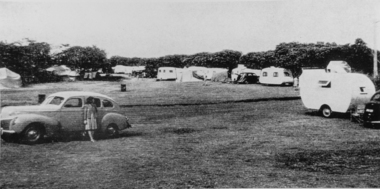
 Ballarat Heritage Services
Photograph, Nucolorvue, Caravans in Victoria Park Camping Ground, Daylesford, 1957
... Victoria Park Caravan Park...Caravans in Victoria Park Camping Ground, Daylesford... Office goldfields Photograph Caravans in Victoria Park Camping ...Daylesford is a tourist town in Central Victorian, known for its mineral water springs.Caravans in Victoria Park Camping Ground, DaylesfordDaylesford, Victoria, Australia This famous holiday resort is famous for its up-to-date facilities, as well as for its natural attractions. The mineral Springs are renowned for their high medicinal elements. The visitor finds ample to amuse, in excellent fishing, boating, Boating, Swimming, golfing, hiking and riding. The district provides a wide range of typical Australian bush scenery, and the altitude of 2,000 feet above sea level as a tonic effect on all. Daylesford has modern hotels, guest houses, shops and places of amusement, also many other places of interest within short travelling distance. Bendigo, 50 miles, Ballara 30 miles, and Melbourne 75 miles, bring Daylesford within easy reach of many parts of Victoria. daylesford, victoria park caravan park, camping, victoria park, caravan park -
 Old Colonists' Association of Ballarat Inc.
Photograph, Thornton Richards, Cottages at the Ballarat Old Colonists' Association Retirement Village, c1960
... Caravan Park... to a caravan park, and Garden Court. ... to a caravan park, and Garden Court. The Old Colonists' Association ...The Old Colonists' Association of Ballarat Inc Retirement Village is located at Charles Anderson Grove.Thirteen black and white cottages at the Ballarat Old Colonists' Association Retirement Village in Charles Anderson Grove, off Gillies Street. The retirement village is next to a caravan park, and Garden Court. old colonists' association ballarat, charles anderson grove, retirement village, garden court, caravan park, wendouree -
Glenelg Shire Council Cultural Collection
Photograph - Photograph - View of Portland Harbour and port, c. 1980
... caravan park.... Portland Harbour with light house and caravan park in foreground... and caravan park in foreground and South Portland and aluminium ...Port of Portland Authority archives.Front: (no inscriptions) Back: (no inscriptions)port of portland archives, portland harbour, lighthouse, caravan park, south portland, aluminium smelter -
 The Beechworth Burke Museum
Photograph, 1960s
... Lake Sambell Caravan Park... Caravan Park and visible in the photograph are individual caravan... was taken in the 1960s at Lake Sambell Caravan Park and visible ...This photograph was taken in the 1960s at Lake Sambell Caravan Park and visible in the photograph are individual caravan sites with electricity outlets, a large single-story building with a caravan park banner, dirt roads, a freestanding message board, and a parked car. Lake Sambell Caravan Park opened in 1959 owing to the work of R.E. Carter, Beechworth Shire engineer from 1954-63. Carter advocated for improvements to the lake and surrounding area in order to encourage tourism in Beechworth. The opening of the caravan park was part of many improvements to Lake Sambell made in this period by Carter including: the swimming pool in 1961, water skiing and boating facilities, and increased lake surface in 1964. These improvements were financed mainly by grants from the Tourist Development Authority. The popularity of caravanning in Australia exploded during this post-war period of the late 1950s and 1960s. This popularity was driven by multiple factors, including: the stopping of fuel rations, the accessibility of car ownership through the manufacturing of affordable cars, technological developments in caravan design, and the increase in prosperity and leisure time for many Australians. Facilities such as electrical outlets to power caravans are present in this photograph of Lake Sambell Caravan Park. Lake Sambell is an artificial lake that was developed on the previous site of the Rocky Mountain Mining Company workings and was officially opened by Minister for Lands, Mr Baily, on October 5, 1928. The disused and unattractive remains of the mine were converted into a recreational area intended for swimming, boating, and fishing. The lake is named after Mr L.H. Sambell, shire engineer and secretary of the Forward Beechworth Committee, who advocated for the enhancement of Beechworth into a tourist destination and was central to the planning and establishment of the lake. This photograph is of historical and social significance in providing insight into caravanning during the 1960s in Australia. Caravanning was extremely popular during the 1960s in Australia due to multiple social and economic factors including the stopping of fuel rations, the accessibility of car ownership through the manufacturing of affordable cars, technological developments in caravan design, and the increase in prosperity and leisure time for many Australians.Black and white rectangle photograph printed on photographic paper and unmounted.Reverse: 3536/ [logo back printing: KODAK/ VELOX/ PAPER] / C798 lake sambell caravan park, lake sambell, caravanning 1960s, caravan park, rocky mountain mining company, kodak velox paper, r.e. carter, l.h. sambell, caravan electricity outlets, tourist development authority, post-war prosperity, forward beechworth committee, lake sambell boating, lake sambell swimming pool, lake sambell fishing, artificial lake, travel 1960s, recreation 1960s -
 The Beechworth Burke Museum
Photograph, 1960s
... Lake Sambell Caravan Park... Caravan Park, visible in the photograph are individual caravan... was taken in the 1960s at Lake Sambell Caravan Park, visible ...This photograph was taken in the 1960s at Lake Sambell Caravan Park, visible in the photograph are individual caravan sites with electricity outlets, a large single-story building, a parked car, and two caravans partially obstructed by trees. Lake Sambell Caravan Park opened in 1959 owing to the work of R.E. Carter, Beechworth Shire engineer from 1954-63. Carter advocated for improvements to the lake and surrounding area in order to encourage tourism in Beechworth. The opening of the caravan park was part of many improvements to Lake Sambell made in this period by Carter including: the swimming pool in 1961, water skiing and boating facilities, and increased lake surface in 1964. These improvements were financed mainly by grants from the Tourist Development Authority. The popularity of caravanning in Australia exploded during this post-war period of the late 1950s and 1960s. This popularity was driven by multiple factors, including: the stopping of fuel rations, the accessibility of car ownership through the manufacturing of affordable cars, technological developments in caravan design, and the increase in prosperity and leisure time for many Australians. Facilities such as electrical outlets to power caravans are present in this photograph of Lake Sambell Caravan Park. Lake Sambell is an artificial lake that was developed on the previous site of the Rocky Mountain Mining Company workings and was officially opened by Minister for Lands, Mr Baily, on October 5, 1928. The disused and unattractive remains of the mine were converted into a recreational area intended for swimming, boating, and fishing. The lake is named after Mr L.H. Sambell, shire engineer and secretary of the Forward Beechworth Committee, who advocated for the enhancement of Beechworth into a tourist destination and was central to the planning and establishment of the lake. This photograph is of historic and social significance in documenting the enhancement of the Lake Sambell area overseen by R.E. Carter and providing insight into caravanning during the 1960s in Australia. Caravanning was extremely popular in Australia during the late 1950s and 60s due to multiple social and economic factors including the stopping of fuel rations, the accessibility of car ownership through the manufacturing of affordable cars, technological developments in caravan design, and the increase in prosperity and leisure time for many Australians. Black and white rectangle photograph printed on photographic paper and unmounted.Reverse: 3538/ [logo back printing KODAK/ VELOX/ PAPER] / C798lake sambell caravan park, lake sambell, lake sambell 1960s, lake sambell fishing, lake sambell boating, lake sambell swimming pool, r.e. carter, l.h. sambell, tourist development authority, caravanning 1960s, caravan electricity outlets, caravan park, forward beechworth committee, rocky mountain mining company, lake caravan park, caravan mid 20th century, beechworth tourism, travel in the 1960s, holiday 1960s -
 Torquay and District Historical Society
Photograph (copy), Early Torquay Beach Scenes
... torquay foreshore caravan park...Photograph shows the caravan park at Torquay front beach....Photograph shows the caravan park at Torquay front beach ...Photograph shows the caravan park at Torquay front beach.A snapshot of past holidays at the beach.Black and white photographtorquay foreshore caravan park -
Clunes Museum
Document, MINUTES FOR PUBLIC MEETING HELD IN THE TOWN HALL CLUNES ON 23/2/1971, 23/02/1971
... SCENIC ROAD AND CARAVAN PARK COMMITTEE... OF A "BACK TO CLUNES", CONSTRUCTION OF A CARAVAN PARK... OF A CARAVAN PARK AND CONSTRUCTION OF A SCENIC TOURISE ROAD FROM ANGUS ...THIS PUBLIC MEETING WAS TO CONSIDER THE FOLLOWING; HOLDING OF A "BACK TO CLUNES", CONSTRUCTION OF A CARAVAN PARK AND CONSTRUCTION OF A SCENIC TOURISE ROAD FROM ANGUS STREET TO FRASER STREET VIA "THE ROCKS" THIS RESULTED IN THE ELECTION OF A "BACK TO CLUNES" COMMITTEE AND THE" SCENIC ROAD AND CARAVAN PARK COMMITTEE".2 X FOOLSCAP PAGES OF THE COPY OF MINUTES HELD IN THE TOWN HALL, CLUNES ON 23/2/1971local history, local government, council, events and celebrations, back to clunes, scenic road and caravan park committee -
 The Beechworth Burke Museum
Photograph, 1960s
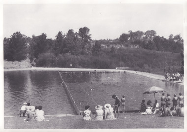
... on Lake Sambell near the caravan park. Lake Sambell...Reverse: Community/ Swimming pool 1960s/ near the caravan... pool 1960s/ near the caravan park/ Lakes? Taken in the 1960s ...Taken in the 1960s, depicted are approximately twenty-nine male and female spectators at a school swimming carnival on Lake Sambell near the caravan park. Lake Sambell is a beautiful Victorian recreation lake and urban park with a unique history. It was created in the mid-1800s by the Rocky Mountain Mining company during the gold rush era and used as a mining site until the early 1900s, which brought Europeans into the area. It was turned into a reserve for residents in 1920 and is considered an icon of Beechworth as it represents the development of the community, human endeavour, and the spirit of the landscape. This photograph represents the post-gold rush era use of Lake Sambell as a recreational reserve. Swimming carnivals were held at the lake and considered a social event for the Beechworth community.Black and white reproduced rectangular photograph print on paper.Reverse: Community/ Swimming pool 1960s/ near the caravan park/ Lakes?lake swimming pool, lake swimming, beechworth carnival processions, carnival, #beechworth, beechworth 1960s, victoria -
Clunes Museum
Photograph
... caravan park... CARAVAN PARK 1/04/1972... AND WOMEN IN SCHOOL UNIFORM .5 PHOTOGRAPH OF CLUNES CARAVAN PARK 1 ...THREE PHOTOGRAPHS OF A PARADE 1972: .1 HORSE AND CART WITH "ERNIE THE FASTED IN THE WEST" WRITTEN ON THE SIDE .2 CLUNES HOSPITAL FLOAT- MEDICAL STAFF OPERATING ON THE FLOAT .3 TWO PEOPLE WITH A FULL WHEEL BARROW "A HUM DAINGER" .4 BACK TO SCHOOL, MAN AND WOMEN IN SCHOOL UNIFORM .5 PHOTOGRAPH OF CLUNES CARAVAN PARK 1/04/1972caravan park, back to school, clunes parade 1972 -
 The Beechworth Burke Museum
Photograph, 1960s
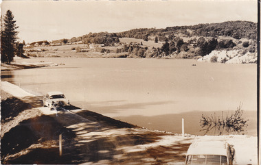
... Lake Sambell Caravan Park... looking down towards Lake Sambell, the caravan park... Sambell, the caravan park, and the surrounding area. This photo ...This photo was taken in the 1960s from a northeast position looking down towards Lake Sambell, the caravan park, and the surrounding area. This photo was taken during a period of rejuvenation for the lake area including the opening of the caravan park in 1959 and the swimming pool area in 1961 (this pool is just visible in the centre of the photo). The popularity of caravanning in Australia exploded during this post-war period of the late 1950s and 1960’s. This popularity was driven by multiple factors, including: the stopping of fuel rations, the accessibility of car ownership through the manufacturing of affordable cars, technological developments in caravan design, and the increase in prosperity and leisure time for many Australians. Lake Sambell is an artificial lake that was developed on the previous site of the Rocky Mountain Mining Company workings and was officially opened by Minister for Lands, Mr Baily, on October 5, 1928. The disused and unattractive remains of the mine were converted into a recreational area intended for swimming, boating, and fishing. The lake is named after Mr L.H. Sambell, shire engineer and secretary of the Forward Beechworth Committee, who advocated for the enhancement of Beechworth into a tourist destination and was central to the planning and establishment of the lake. Funding for the project was raised by both competition funds and donations. Since the construction in 1928 several engineering issues have arisen. In 1939 the water levels were low, and the lake was considered both an eyesore and ‘mudhole’, Beechworth Shire Council sort funding to raise the height of the lake six feet to improve the quality of water. Throughout the 1940s the Beechworth Swimming Club tried to raise awareness and funds to address the structural engineering issues and improve swimming facilities at the lake. R.E. Carter, similar to L.H. Sambell, was a shire engineer who advocated the importance of positioning Beechworth as a tourist destination. Carter held the position from 1954-63 and organised many improvements to the Lake Sambell area including the caravan park in 1959, the lake swimming pool in 1961, water skiing and boating facilities, and increased the lake surface are in 1964. These improvements were financed mainly by grants from the Tourist Development Authority. This photograph is of historical significance as it documents Lake Sambell and the surrounding area in the 1960s after a phase of enhancements to improve the appearance and usability for both the people of Beechworth and tourists. It is also of social significance in providing an insight into the increase in leisure time and access to travel during a period of post-war prosperity.Black and white rectangle photograph printed on matte photographic paper and unmounted.Reverse: 1 / [logo KODAK/ VELOX/ PAPER] / C798 / 3535lake sambell, lake sambell caravan park, lake sambell swimming pool, caravan park, caravanning 1960s, rocky mountain mining company, l.h. sambell, r.e. carter, beechworth swimming club, forward beechworth committee, minister of lands, tourist development authority, lake swimming, swimming, boating, fishing, water skiing, beechworth 1960s, lake sambell fishing, lake sambell boating -
 Apollo Bay Museum
Audio - Norma Begely Oral History Interview April 2023, Apollo Bay
... caravan park..., Waratah Caravan Park, 1960s, 1970s, Otways... Bay School, Waratah Caravan Park, 1960s, 1970s, Otways Apollo ...Local Otways residents (Gadubanud Country) were interviewed by artist/researcher Amy Tsilemanis for the 2023 storytelling project Heart Maps, a collaboration with the Apollo Bay Museum and Historical Society. Themes include memories of communication technologies, entertainments, school, work, community, and life near the ocean. More information here: https://amytsilemanis.com.au/portfolio/heart-maps In this interview: teaching, Apollo Bay School, Waratah Caravan Park, 1960s, 1970s, OtwaysMP3 Audio file apollo bay, teaching, caravan park -
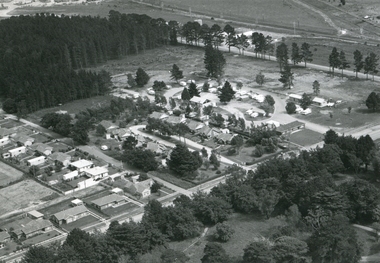
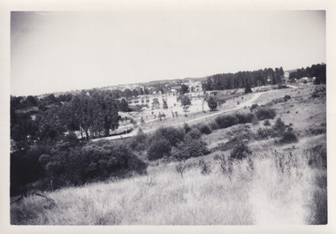
 Lake Bolac & District Historical Society
Black and white photograph, Aerial view of Lake Bolac township, circa 1970
... course, bowling club, caravan park, aquatic club shed, Primary... (centre back) and to its left are the early caravan park...) and to its left are the early caravan park and bowling club ...Lake Bolac township, 1970. This picture shows the 2nd football oval, tennis courts, golf course and racecourse (front-right) above the salt lake and the Lake Bolac Common (front-left). The Primary School is still on its original site between the oval and the Ararat road. The High School is beside the fresh-water lake (centre back) and to its left are the early caravan park and bowling club. The Aquatic Club shed can just be seen behind the lake bank. Photograph taken by Lewis Wills.lake bolac, football oval, tennis courts, race track, golf course, bowling club, caravan park, aquatic club shed, primary school, high school -
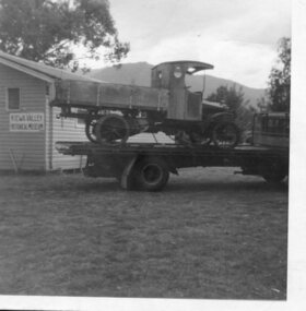 Kiewa Valley Historical Society
Photograph- Paddy Fisher's truck at Tawonga, 13th Dec. 1969
... was located at Tawonga Caravan Park and was later relocated to its... taken at Tawonga Caravan Park 13th December, 1969'... 'Paddy fisher's truck taken at Tawonga Caravan Park 13th December ...The Hallford truck was made by J & E Hall, of Dartford, England, whose business commenced in 1785. In 1926 the Fisher family of Mongan's Bridge took delivery of the 1923 Hallford truck which was used on the farm to transport cream to the Kiewa Butter Factory in Tangambalanga. In 1967, the truck was sold to Mr Greg Bedstead and other members of the Kiewa Valley Historical Society for the KVHS who reimbursed them at a later date. The truck was housed at the Butter Factory for many years and was paraded on special occasions. Photograph shows truck parked outside the original Kiewa Valley Historical Museum which was located at Tawonga Caravan Park and was later relocated to its current location at the Mt Beauty Information Centre. This truck was used to transport cream to the Kiewa Butter Factory from the Fisher family's dairy farm at Mongan's Bridge. At other times a tyre was removed and a belt attached to run a chaff cutter. This truck has historical significance as it is presentative of vehicles which were used by farmers to transport cream to the butter factories by a local family. Furthermore, it has social significance as KVHS members combined their finances to purchase this truck so it would be part of our collection. It is well provenanced and has an excellent interpretive capacity.Black and white photograph of Paddy Fisher's truck on a flat bed truck, outside the original Kiewa Valley Historical MuseumSmall typed tag on back of photo 'Paddy fisher's truck taken at Tawonga Caravan Park 13th December, 1969'hallford truck, fisher family, kiewa valley farmers, mongan's bridge, cream truck -
 The Beechworth Burke Museum
Photograph, 1960s
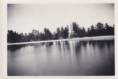
... caravan park... swimming facilities, paddling pool and caravan park. ... facilities, paddling pool and caravan park. This photograph holds ...Taken around 1960s, this photograph shows the banks of Lake Sambell. Lake Sambell is named after Mr. L. H. Sambell who was instrumental in the lake's formation. Lake Sambell is the original site of the open sluice operation of Rocky Mountain Mining Company in the 1800s and the early 1900s. In the early 1920s, it was reconstructed as a recreational lake and was formally opened to public on 6 October 1928. The opening event was attended by townspeople and Beechworth's Minister of Lands Mr. Bailey. In the late 1930s to early 1940s, Lake Sambell redeveloped. The first development aimed to raise the banks by six feet to double its present area and to make the water cleaner. Another redevelopment in the 1940s was made possible by the Beechworth and District Progress Association. It involved raising the banks to five feet to provide swimming facilities, paddling pool and caravan park. This photograph holds Historic significance because of its connection to the development of Beechworth district.Sepia rectangular photograph printed on matte photographic paperObverse: Reverse: 3533 /beechworth, water scheme, water reserve, catchments, beechworth water reserve, beechworth catchments, municipal council, lakes, reserve, water supply, political projects, environmental changes, mr. l. h. sambell, sambell, rocky mountain mining company, recreational lake, minister of lands, mr. bailey, swimming pool, paddling pool, caravan park, swimming facilities, lake redevelopment, funding -
Clunes Museum
Map - MAPS, 28/02/1971
... ORIGINAL MAP - CLUNES CARAVAN PARK... ORIGINAL MAP - CLUNES CARAVAN PARK LOCAL HISTORY DOCUMENT MAPS ...ORIGINAL MAP - CLUNES CARAVAN PARKlocal history, document, maps, clunes township -
 The Beechworth Burke Museum
Photograph, 1960s
... Lake Sambell Caravan Park... Sambell area including the caravan park in 1959, the lake swimming... Sambell area including the caravan park in 1959, the lake swimming ...This photograph was taken in the 1960s at Lake Sambell and is a view across the lake from the east side, the photo was taken during a period of improvements to the lake and surrounding area. Lake Sambell is an artificial lake that was created on the site of the old Rocky Mountain Mining Company workings and was officially opened by Minister for Lands, Mr Baily, on October 5, 1928. The disused and unattractive remains of the mine were converted into a recreational area intended for swimming, boating, and fishing. The lake is named after Mr L.H. Sambell, shire engineer and secretary of the Forward Beechworth Committee, who advocated for the enhancement of Beechworth into a tourist destination and was central to the planning and establishment of the lake. Funding for the project was raised through both competition funds and donations. Since the construction in 1928 several engineering issues have arisen. In 1939 the water levels were low, and the lake was considered both an eyesore and ‘mudhole’, Beechworth Shire Council sort funding to raise the height of the lake six feet to improve the quality of water. Throughout the 1940s the Beechworth Swimming Club sort to address the structural engineering issues and improve swimming facilities at the lake. R.E. Carter, similar to L.H. Sambell, was a shire engineer who advocated the importance of positioning Beechworth as a tourist destination. Carter held the position of shire engineer from 1954-63 and organised many improvements to the Lake Sambell area including the caravan park in 1959, the lake swimming pool in 1961, water skiing and boating facilities, and increased the lake surface area in 1964. These improvements to the lake also reflect an increase in leisure time and access to travel during a period of post-war prosperity in Australia during the 1950s and 60s. This photograph is of historical significance as it documents Lake Sambell in the 1960s after a series of enhancements to the lake area to improve its appearance and usability for both the people of Beechworth and tourists. It is also of social significance in providing an insight into the increase in leisure time and access to travel during a period of post-war prosperity. Black and white rectangle photograph printed on photographic paper and unmounted.Reverse: 3534 C798lake sambell, l.h. sambell, r.e. carter, rocky mountain mining company, forward beechworth committee, beechworth swimming club, wallace park lake sambell development scheme, lake sambell caravan park, beechworth 1960s, lake sambell swimming pool, lake sambell boating, lake sambell fishing, swimming, boating, water skiing, fishing, post-war prosperity, minister of lands, artificial lake, open cut sluice mine, lake -
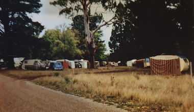
 Stawell Historical Society Inc
photograph - Slides, Ian McCann, Grampians Gate Enterance, 1976 - 1984
... Gate Caravan Park... Photograph showing the entrance to the Grampians Gate Caravan Park ...Colour Photograph showing the entrance to the Grampians Gate Caravan Park -
 Marysville & District Historical Society
Booklet (Item) - Tourist guide, Ian and Danese Walshe et al, MARYSVILLE and district TOURIST GUIDE, 1982
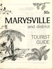
... black spur motel and caravan park... shop tudor lodge black spur motel and caravan park buxton ...A tourist guide outlining services, accommodation, activities and places of interest to visit in and around Marysville and the local district.A tourist guide outlining services, accommodation, activities and places of interest to visit in and around Marysville and the local district.marysville, victoria, australia, tourist guide, marysville hotel, castles' store, hawthorne's corner shop, tudor lodge, black spur motel and caravan park, buxton general store, golden fleece roadhouse, marysville garage, burrengeen park, lake mountain, steavenson falls, nanda binya lodge, alpenglow nursery, black spur inn hotel, silver stream trout farm, mccfarlane's grocery, barton's drapery, marysville newsagency, eildon explorer, beauty spot nursery, crossways, pumpernickel, mckenzie's tourist services, blue hills riding school, mountain view horse hire, pitt's garage, maryton park, j l gould sawmill, eildon deer park, eildon weir, maroondah dam, snob's creek, healesville sanctuary, graceburn park, cathedral range, beauty spot walk, tree fern gully walk, michaeldene track, keppel track, woods lookout track, cumberland scenic reserve, cambarville, the big tree, cora-lyn falls, barton's lookout, cumberland falls, sovereign view, wirreanda festival, scenic motel, tower motel, marylands guest house, kooringa guest house, marylyn guest house, mountain lodge, el kanah, marysville hotel motel, buxton hotel motel, black spur inn, buxton caravan park, marysville caravan park, the cumberland, marysville recreation and fun park -
 Marysville & District Historical Society
Booklet (Item) - Tourist guide, Ian and Danese Walshe et al, MARYSVILLE and district TOURIST GUIDE, 1982
... black spur motel and caravan park... shop tudor lodge black spur motel and caravan park buxton ...A tourist guide outlining services, accommodation, activities and places of interest to visit in and around Marysville and the local district.A tourist guide outlining services, accommodation, activities and places of interest to visit in and around Marysville and the local district.marysville, victoria, australia, tourist guide, marysville hotel, castles' store, hawthorne's corner shop, tudor lodge, black spur motel and caravan park, buxton general store, golden fleece roadhouse, marysville garage, burrengeen park, lake mountain, steavenson falls, nanda binya lodge, alpenglow nursery, black spur inn hotel, silver stream trout farm, mccfarlane's grocery, barton's drapery, marysville newsagency, eildon explorer, beauty spot nursery, crossways, pumpernickel, mckenzie's tourist services, blue hills riding school, mountain view horse hire, pitt's garage, maryton park, j l gould sawmill, eildon deer park, eildon weir, maroondah dam, snob's creek, healesville sanctuary, graceburn park, cathedral range, beauty spot walk, tree fern gully walk, michaeldene track, keppel track, woods lookout track, cumberland scenic reserve, cambarville, the big tree, cora-lyn falls, barton's lookout, cumberland falls, sovereign view, wirreanda festival, scenic motel, tower motel, marylands guest house, kooringa guest house, marylyn guest house, mountain lodge, el kanah, marysville hotel motel, buxton hotel motel, black spur inn, buxton caravan park, marysville caravan park, the cumberland, marysville recreation and fun park -
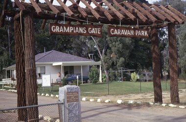 Stawell Historical Society Inc
photograph - Slides, Ian McCann, Grampians Gate Enterence, 1976 -1984
... of the Grampians Gate Caravan Park... Photograph . Close up of the Entrance of the Grampians Gate Caravan ...Colour Photograph . Close up of the Entrance of the Grampians Gate Caravan Park