Showing 386 items matching "central planning"
-
 Tatura Irrigation & Wartime Camps Museum
Photograph, Central Planning Office, Camp 2 aerial, 1989
... on the back: camp 2 W/c 0065 Vic 82/.9032 Max 1989 Central Planning Office Treasury Place Melbourne...Central Planning Office...Tatura Irrigation & Wartime Camps Museum 49 Hogan Street Tatura the-murray on the back: camp 2 W/c 0065 Vic 82/.9032 Max 1989 Central Planning Office Treasury Place Melbourne Black and white aerial photo of camp 2 Camp 2 aerial Photograph Central Planning Office ...Black and white aerial photo of camp 2on the back: camp 2 W/c 0065 Vic 82/.9032 Max 1989 Central Planning Office Treasury Place Melbourne -
Lakes Entrance Historical Society
Book, Central Planning Authority, Victoria, Resources Survey East Gippsland Region, 1954
... Central Planning Authority, Victoria...Resources Survey East Gippsland Region Book Central Planning Authority, Victoria ...A review of the physical, economic, and public resources of East Gippsland, Victoria.primary industry -
 Bendigo Historical Society Inc.
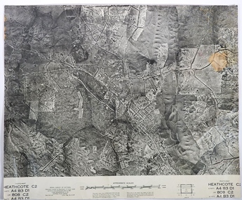
Map - FRED COWIE COLLECTION: AERIAL MAPS OF HEATHCOTE/EPPALOCK, 28-9-1960
... Copied photographically at the Central Plan Office.Fred Cowie,46 McIvor Rd,Bgo.....Central Plan Office...Copied photographically at the Central Plan Office.Fred Cowie,46 McIvor Rd,Bgo.. ...Map, Heathcote C2, Township of Heathcote, Melbourne Road through town branching off to Bendigo & Echuca. Aerial Survey of Victoria. Photo-map prepared by Department of Crown Lands and Survey from photographs taken in 1960. Copied photographically at the Central Plan Office.Fred Cowie,46 McIvor Rd,Bgo..Central Plan Officemap, heathcote, fred cowie -
 Bendigo Historical Society Inc.
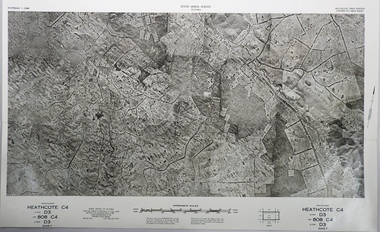
Map - FRED COWIE COLLECTION: AERIAL MAPS OF HEATHCOTE/EPPALOCK, 28-9-60
... Copied photographically at the Central Plan Office.Date 28-9-60,C.P.O.Neg.No.21590.Scale 4 inches to 1 mile. ...Central Plan Office....Copied photographically at the Central Plan Office.Date 28-9-60,C.P.O.Neg.No.21590.Scale 4 inches to 1 mile. ...Map, Heathcote C4, Aerial Survey of Victoria,Photo-map prepared by Department of Crown Lands and Survey from photographs taken in 1960. Copied photographically at the Central Plan Office.Date 28-9-60,C.P.O.Neg.No.21590.Scale 4 inches to 1 mile. Fred Cowie,46 McIvor Rd,Bgo..Central Plan Office.map, heathcote, fred cowie -
 Bendigo Historical Society Inc.
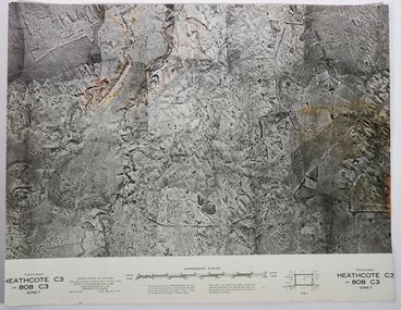
Map - FRED COWIE COLLECTION: AERIAL MAPS OF HEATHCOTE/EPPALOCK, 28-9-60
... Map, Heathcote C3, Aerial Survey of Victoria, Photo-map prepared by Department of Crown Lands and Survey from photographs taken in 1960.Copied photographically at the Central Plan Office. Date 28-9 60, C.P.O.Neg. No.21588.Campaspe River, Coliban River. ...Central Plan Office....History House 11 Mackenzie Street Bendigo goldfields MAP Heathcote Fred Cowie Central Plan Office. Map, Heathcote C3, Aerial Survey of Victoria, Photo-map prepared by Department of Crown Lands and Survey from photographs taken in 1960.Copied photographically at the Central Plan Office. ...Map, Heathcote C3, Aerial Survey of Victoria, Photo-map prepared by Department of Crown Lands and Survey from photographs taken in 1960.Copied photographically at the Central Plan Office. Date 28-9 60, C.P.O.Neg. No.21588.Campaspe River, Coliban River. Flower Hill. Fred Cowie,46 McIvor Rd.Bendigo (Not located 29.9.2022)Central Plan Office.map, heathcote, fred cowie -
 University of Melbourne, Burnley Campus Archives
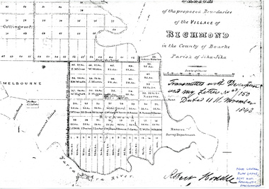
Plan - Photocopy, Sketch of the Proposed Boundaries of the Village of Richmond, 1843
... Survey Department." original in Central Plan Office, Department of Natural Resources and Environment...In ink: From Central Plan Office Dept. Nat. Resources & Environment...Survey Department." original in Central Plan Office, Department of Natural Resources and Environment Sketch of the Proposed Boundaries of the Village of Richmond Plan Photocopy ...Sketch of the proposed boundaries of the village of Richmond in the County of Bourke Parish of Jika-Jika. Handwritten on original: "Transmitted with Description and my letter No 43/150 Dated 11th November 1843 Robert Hoddle." Shows Burnley Gardens site as "Reserve. Survey Department." original in Central Plan Office, Department of Natural Resources and EnvironmentIn ink: From Central Plan Office Dept. Nat. Resources & Environmentrichmond, jika-jika, survey department, yarra river, robert hoddle -
Federation University Historical Collection
Book, Frank Hurley, An Event That Never Happened: The history and politics of decentralisation in Victorian and New South Wales 1885-1985 (Thesis), 1989
... ...central planning...Frank hurley thesis doctorate decentralisation ppoulation economics policy Closer settlement acts urbanisation decentralisation league war and reconstruction central planning town planning victorian Decentralisatoin League Owen paper mill Slough Estate Noel Mobbs Ballarat Common Edgar Bartrop Australian Paper Mills Bendix Mintex ball ballarat development committee Red hard covered thesis undertaken for a Doctory of Philosphy ot the University of Melbourne. ...This thesis is an account of movements and policies for decentralisation of population and economic activity away from metropolitan to non-metropolitan areas in Victoria and New South Wales between 1885 and 1985. Red hard covered thesis undertaken for a Doctory of Philosphy ot the University of Melbourne. frank hurley, thesis, doctorate, decentralisation, ppoulation, economics, policy, closer settlement acts, urbanisation, decentralisation league, war and reconstruction, central planning, town planning, victorian decentralisatoin league, owen paper mill, slough estate, noel mobbs, ballarat common, edgar bartrop, australian paper mills, bendix mintex, ball, ballarat development committee -
 Ringwood and District Historical Society
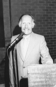
Photograph, Ringwood Historical Society 25th Birthday guest speaker, 1983
... Written on back of photograph: "Speaker 1983 was Head of Central Plan Office at Silver Jubilee. Bob Spreadborough"....Ringwood and District Historical Society 125A Warrandyte Road Ringwood North melbourne Written on back of photograph: "Speaker 1983 was Head of Central Plan Office at Silver Jubilee. Bob Spreadborough". ...Black and white photographWritten on back of photograph: "Speaker 1983 was Head of Central Plan Office at Silver Jubilee. Bob Spreadborough". -
University of Melbourne, Burnley Campus Archives
Plan - Photocopy, Proposed Reserve for Horticultural and Experimental Garden in the Survey Paddock Richmond, 1862-1948
... Photocopy of Plan Gazetted 01.08.1863. From Central Plan Office Department of Natural Resources....Handwritten notes on back "Melb Roll 23, R.19(A)" Photocopy of Plan Gazetted 01.08.1863. From Central Plan Office Department of Natural Resources. ...Photocopy of Plan Gazetted 01.08.1863. From Central Plan Office Department of Natural Resources.Original signed by Clement Hodgkinson, Deputy Surveyor General. Stamped Department of Lands and Survey 7.12.48 Neg.18377. Handwritten notes on back "Melb Roll 23, R.19(A)"burnley, horticultural and experimental garden, survey paddock, richmond, clement hodgkinson -
Port Melbourne Historical & Preservation Society
Essay - Thesis, Competing ideas for the inner city, F Patricia Hawkins, Competing ideas for the inner city, 1991
... Competing ideas for the inner city - local responses to central planning initiatives in the City of Port Melbourne 1925 - 1985 by F Patricia Hawkins, 1991...Port Melbourne Historical & Preservation Society Port Melbourne Town Hall 333 Bay Street Port Melbourne melbourne Minor thesis submitted as part of the Master of Arts in Public History, Monash University, by Pat Hawkins, member of the PMH&PS built environment town planning local government - city of port melbourne f patricia (pat) hawkins Competing ideas for the inner city - local responses to central planning initiatives in the City of Port Melbourne 1925 - 1985 by F Patricia Hawkins, 1991 Competing ideas for the inner city Essay Thesis, Competing ideas for the inner city, F Patricia Hawkins ...Minor thesis submitted as part of the Master of Arts in Public History, Monash University, by Pat Hawkins, member of the PMH&PSCompeting ideas for the inner city - local responses to central planning initiatives in the City of Port Melbourne 1925 - 1985 by F Patricia Hawkins, 1991built environment, town planning, local government - city of port melbourne, f patricia (pat) hawkins -
University of Melbourne, Burnley Campus Archives
Plan - Photocopy, Contour Map 1891, 1891
... Shows Pavilion and Principal's Residence but not much of the garden design. From Central Plan Office Dept. of Natural Resources....Shows Pavilion and Principal's Residence but not much of the garden design. From Central Plan Office Dept. of Natural Resources. ...Photocopy of plan showing contour lines from Yarra River. Shows Pavilion and Principal's Residence but not much of the garden design. From Central Plan Office Dept. of Natural Resources."Contour map 1891" written in biroyarra river, pavilion, burnley horticultural college, burnley gardens -
Box Hill Historical Society
Book, Zenith Development Corporation, Box Hill District Centre : a structural plan proposal, 1/12/1990 12:00:00 AM
... ...Town planning...Central...Box Hill Historical Society Box Hill Heritage Centre Suite 7 Town Hall Hub Box Hill melbourne Box Hill Zenith Development Corporation Town planning Central Business District A submission made as a contribution to the Box Hill Structure Plan and, in particular, to the exhibition of the "Options for the 1990's" publication, by Box Hill City Council. ...A submission made as a contribution to the Box Hill Structure Plan and, in particular, to the exhibition of the "Options for the 1990's" publication, by Box Hill City Council.box hill, zenith development corporation, town planning, central business district -
 Tatura Irrigation & Wartime Camps Museum
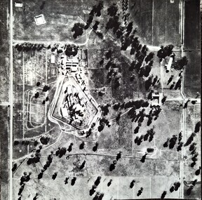
Photograph, Aerial Photograph Dhurringile Mansion, 1940
... Obtain May 1989 from the Historic Photographs Department, Treasury Place, Melbourne (Central Planning Office). ...Obtain May 1989 from the Historic Photographs Department, Treasury Place, Melbourne (Central Planning Office). dhurringile pow camp Dhurringile aerial photo Black and white photograph. ...Dhurringile POW camp aerial photograph. Obtain May 1989 from the Historic Photographs Department, Treasury Place, Melbourne (Central Planning Office). Black and white photograph. Aerial photo of Dhurringile Camp and surrounding area. North is at top of picture.dhurringile pow camp, dhurringile aerial photo -
Port Melbourne Historical & Preservation Society
Plan - Central rockery, Graham Street between Station and Princes Street, Port Melbourne, Engineering Department, City of Port Melbourne, 1950s
... Plan - Central rockery in Graham Street between Station and Princes Street, 1950s....Plan Central rockery, Graham Street between Station and Princes Street, Port Melbourne Engineering Department, City of Port Melbourne ...Plan - Central rockery in Graham Street between Station and Princes Street, 1950s.built environment - civic, parks and gardens -
Whitehorse Historical Society Inc.
Map, Melbourne Metropolitan Planning Scheme. Map No 39, c1950
... Map of central Melbourne showing planning zones with gardens and principal buildings marked....Map of central Melbourne showing planning zones with gardens and principal buildings marked. ...Map of central Melbourne showing planning zones with gardens and principal buildings marked.Map of central Melbourne showing planning zones with gardens and principal buildings marked.Map of central Melbourne showing planning zones with gardens and principal buildings marked.maps, city of melbourne, city of fitzroy, city of south melbourne, city of collingwood -
Stawell Historical Society Inc
Memorabilia - Realia, Town of Stawell, Plans of Central Park Development, 1980
... Stawell Football Clubrooms Plans of Central Park Development...Stawell Historical Society Inc 46 Longfield St Stawell grampians Stawell Sport Football Central Park Stawell Football Clubrooms Plans of Central Park Development Plans of Central Park Development Memorabilia Realia Town of Stawell ...Stawell Football Clubrooms Plans of Central Park Developmentstawell, sport, football, central park -
Stawell Historical Society Inc
Memorabilia - Realia, Plans of Central Park Development, 1980
... Stawell Football Clubrooms Plans of Central Park Development...Stawell Historical Society Inc 46 Longfield St Stawell grampians Stawell Sprt Football Central Park Stawell Football Clubrooms Plans of Central Park Development Plans of Central Park Development Memorabilia Realia Town of Stawell ...Stawell Football Clubrooms Plans of Central Park Developmentstawell, sprt, football, central park -
Stawell Historical Society Inc
Memorabilia - Realia, Plans of Central Park Development, 1980
... Stawell Football Clubrooms Plans of Central Park Development...Stawell Historical Society Inc 46 Longfield St Stawell grampians Stawell Sport Football Central Park Stawell Football Clubrooms Plans of Central Park Development Plans of Central Park Development Memorabilia Realia Town of Stawell ...Stawell Football Clubrooms Plans of Central Park Developmentstawell, sport, football, central park -
Stawell Historical Society Inc
Memorabilia - Realia, Town of Stawell, Sept 1980
... Stawell Football Clubrooms. Plans of Central Park Development...Stawell Historical Society Inc 46 Longfield St Stawell grampians Stawell Football Sport Central Park Stawell Football Clubrooms. Plans of Central Park Development Memorabilia Realia Town of Stawell ...Stawell Football Clubrooms. Plans of Central Park Developmentstawell, football, sport, central park -
Bendigo Historical Society Inc.
Map - BENDIGO PARISH PLAN
... Bendigo Parish Plan Central Bendigo. Canvas with Canvas typed edges. ...History House 11 Mackenzie Street Bendigo goldfields BHS Collection Bendigo Parish Plan Central Bendigo. Canvas with Canvas typed edges. ...BHS CollectionBendigo Parish Plan Central Bendigo. Canvas with Canvas typed edges. Taken from George Black's maps -
 Falls Creek Historical Society
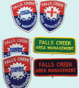
Badge - Falls Creek Area Management Cloth Badges
... Its composition changed over time but generally the Committee was composed of representatives of the State Electricity Commission, Representatives from Ski Clubs and commercial enterprises, the Country Roads Board, the Ski Tow company and a Representative of the Upper Murray Regional Committee of the Central Planning Authority. This Committee was responsibility for long term planning for the Falls Creek Tourist Area as well as the day to day running of the Village, These patches were part of the uniform of people employed by the Management Committee....Its composition changed over time but generally the Committee was composed of representatives of the State Electricity Commission, Representatives from Ski Clubs and commercial enterprises, the Country Roads Board, the Ski Tow company and a Representative of the Upper Murray Regional Committee of the Central Planning Authority. This Committee was responsibility for long term planning for the Falls Creek Tourist Area as well as the day to day running of the Village, These patches were part of the uniform of people employed by the Management Committee. ...Falls Creek was operated by the Falls Creek Area Management Committee. Its composition changed over time but generally the Committee was composed of representatives of the State Electricity Commission, Representatives from Ski Clubs and commercial enterprises, the Country Roads Board, the Ski Tow company and a Representative of the Upper Murray Regional Committee of the Central Planning Authority. This Committee was responsibility for long term planning for the Falls Creek Tourist Area as well as the day to day running of the Village, These patches were part of the uniform of people employed by the Management Committee.These cloth badges are significant because they indicated employees of the Area Management Committee and the role they played in Falls Creek.A group of cloth badges indicating the role of personnel employed by the Falls Creek Area Management. Shield shaped badges - 2 Falls Creek Area Management - PARKING CONTROL 1 Falls Creek Area Management - with red cross of SKI PATROL Rectangular - Green and yellow - FALLS CREEK AREA MANAGEMENT Red and blue - FALLS CREEK AREA MANAGEMENTfalls creek village, falls creek area management committee -
Bendigo Historical Society Inc.
Map - YALLOOK : COUNTY OF BENDIGO, 1957
... For survey information application should be made to the central plan office, or to the office of titles. ...For survey information application should be made to the central plan office, or to the office of titles. ...Map. Yallook, County of Bendigo, Talambe, Neilborough, Yarraberb, Salisbury, Pompapiel. Drawn and reproduced at the Department of Lands and Survey, Melbourne,1957. Distances shown on the plan are derived from original surveys of varying dates and whilst approximately correct do not necessarily conform to modern standards of accuracy. For survey information application should be made to the central plan office, or to the office of titles. Some ink scibbles appear at the right top of this map. Price 2/-. (number 14 in map cupboard 1)By Authority W.M.Houston, Govt.Printer,Melbourne.map, bendigo, yallook -
Bendigo Historical Society Inc.
Plan - Central Nell Gwynne shaft
... Central Nell Gwynne shaft Plan forms part of the Margaret Roberts Collection....Plan Central Nell Gwynne shaft ...Central Nell Gwynne shaft is located at the end of Happy Valley Road (Ernest Street), Ironbark, BendigoCentral Nell Gwynne shaft Plan forms part of the Margaret Roberts Collection.gold mining, gold, central nell gwynne, bendigo, happy valley road, ironbark -
 University of Melbourne, Burnley Campus Archives
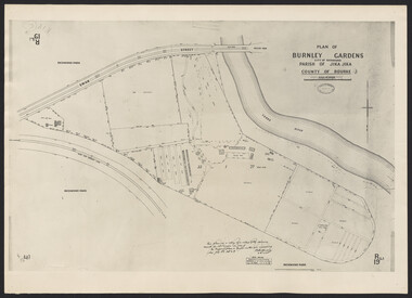
Photograph - Cul-de-sac planting design, Plan of Burnley Gardens, City of Richmond, Parish of Jika Jika, County of Bourke, 1948 (photograph)
... Photographed at Dept. of Lands and Survey, central plan office, 7/12/1948. Plan shows old orchard, fowl sheds, coops and yards, milking shed, silo, nursery, glass house, fattening pens, dairy, garden, orchards area in southwest area. ...Photographed at Dept. of Lands and Survey, central plan office, 7/12/1948. Plan shows old orchard, fowl sheds, coops and yards, milking shed, silo, nursery, glass house, fattening pens, dairy, garden, orchards area in southwest area. ..."This plan is a copy of a copy of the survey made by Mr. Turner in 1926. The original plan and field notes are missing. See file Rs 3529" Signed by ? Andersonburnley gardens, victoria department of lands & survey, richmond, orchards, fowl yards -
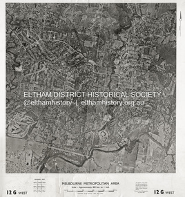 Eltham District Historical Society Inc
Photograph - Aerial Photograph, Central Plan Office, Eltham, Jan. 1960
... Historic Aerial Imagery Source: Central Plan Office Neg. No. 21451 (Print) Dept. of Lands & Survey and the Melb. & Metro. ...Central Plan Office...Historic Aerial Imagery Source: Central Plan Office Neg. No. 21451 (Print) Dept. of Lands & Survey and the Melb. & Metro. ...Centred on Bolton Street and Brougham Street, Eltham bounded by Progress Road to north, Yarra River to south, Andrews Street and Euclyptus Road to east and Greensborough Railway Station to west. Historic Aerial Imagery Source: Central Plan Office Neg. No. 21451 (Print) Dept. of Lands & Survey and the Melb. & Metro. Board of Works. Aerial Photo Details: MELBOURNE METROPOLITAN AREA Section : 12 G West Date : Jan./Feb. 1960 Scale : 800 feet to 1 inch 37°43'18.2"S 145°08'13.0"E Melways : 21 J6 (ed. 42)aerial photo, lower plenty, main road, montmorency, eltham, eltham lower park, heidelberg golf club, hurstbridge railway line, main road eltham, yarra river, 1960-01, andrews street, arthur street, bolton street, briar hill, brougham steet, dave lyon house, eltham north, eltham-yarra glen road, ernie andrew house, eucalyptus road, greensborough railway station, henry street, karingal road, melway 21j6, montmorency railway station, mount pleasant road, progress road, railway road, southernwood, were street -
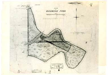 University of Melbourne, Burnley Campus Archives
Plan, Plan of Richmond Park, 1886-1948
... Stamp, "Department of Lands and Survey Photographed at the Central Plan Office 1/1 Plate 7.12.48" (2) Also 2 photocopies, 1 reduced - possibly used in a publication...Stamp, "Department of Lands and Survey Photographed at the Central Plan Office 1/1 Plate 7.12.48" (2) Also 2 photocopies, 1 reduced - possibly used in a publication Plan of Richmond Park Plan ...(1) Black and white photographed copy of an original coloured plan. Plan of Richmond Park with Horticultural Society Gardens marked in. Includes additional land which became the Field Station. Original plan dated 31 August 1872, note of Crown Grant to the Board of Land & Works and Richmond City Council 1886; showing land, "Permanently Preserved for the Gardens". Stamp, "Department of Lands and Survey Photographed at the Central Plan Office 1/1 Plate 7.12.48" (2) Also 2 photocopies, 1 reduced - possibly used in a publication1 photocopy has "Figure 1. Plan of Burnley Gardens circa 1863 [sic]gardens, richmond, horticultural society of victoria, richmond park, a.l. martin -
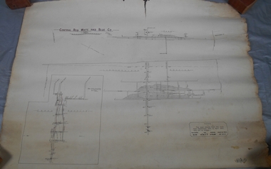 Bendigo Historical Society Inc.
Map - Central Red White and Blue Co, 1913
... Printed name on top of plan: 'Central Red White and Blue Co' Plan printed by Troedel & Cooper Pty Ltd. ...Printed name on top of plan: 'Central Red White and Blue Co' Plan printed by Troedel & Cooper Pty Ltd. ...The Central Red White and Blue Gold Mine was Bendigo's leading gold mine from 1910 - 1913. During the mine's operation, the main shaft was sunk 670 metres, and retrieved over 2500KG of gold. The Central Red White and Blue Gold Mine was located on the corner of Chum St and Honeysuckle St in Golden Square.. During the mine's operation, the main shaft was sunk 670 metres, and retrieved over 2500KG of gold. The registration of the Company in 1891 (Government Gazette 138, November 6th. 1891, page 4465) lists the value of the Company's property as three hundred and fifty pounds. The number of shares was thirty thousand at 2 shillings each. The Manager was Mr. William Weeks Barker. Ref: https://gazette.slv.vic.gov.au/view.cgi?year=1891&class=general&page_num=4465&state=v&classnum=g138&id= Extract from Whitelaw Report: Central Red White and Blue Mine, Bendigo. Author: H E Whitelaw Abstract Early in 1910, some considerable time after it had become generally known that a rich reef at a depth of 405 ft was being worked southward from the privately owned Lansell's Little 180 shaft and immediately following the plotting of the Geological Survey pitch diagram of the Sheepshead line of reefs, some wide awake local mining men seized the opportunity to secure the holding known as Eadie's which, overlapping Lansell's lease and containing a stretch of the Sheepshead reef channel between the Little 180 north and south shafts, had been declared void some five years previously. That the Lansell Estate did not acquire this property on its becoming available is puzzling in the light of the fact that in Eadie's day the late Mr G W Lansell, on discovering auriferous spurs in the south shaft (now the Central Blue) had offered 2,000 pounds for, and a percentage of gold won from the lease. https://search.informit.org/doi/10.3316/aesis.200105326 Hand drawn plan of Central Red, White and Blue Mine. Cross section and longitudinal plan drawn on plan. Printed name on top of plan: 'Central Red White and Blue Co' Plan printed by Troedel & Cooper Pty Ltd. Surveyor W. H. Cundy, Bendigo April 1913 Plan is part of the Margaret Roberts Collection of mining records.bendigo, margaret roberts, gold, central red white and blue gold mine, map, margaret roberts collection -
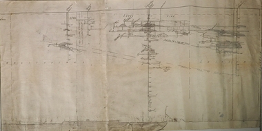 Bendigo Historical Society Inc.
Plan - Central Blue Gold Mine, Unknown
... Longitudinal plan of Central Blue and Little 180 gold mines underground workings. ...Plan Central Blue Gold Mine ...Lansell's Little 180 gold mine was located on the corner of Alley Street and Mt. Korong Road. Longitudinal plan of Central Blue and Little 180 gold mines underground workings. Hand drawn in pencil, with shadings. Shafts marked: Central Blue and Sheepshead shaft. Plan forms part of the Margaret Roberts Collection.gold mining, gold, bendigo, central blue -
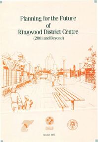 Ringwood and District Historical Society
Pamphlet, Planning for the Future of Ringwood District Centre 2001 and Beyond - October 1987
... A4 size 6-page multi-fold consultants' report outlining Ringwood's central structure plan for the new millennium. Topics: Traffic Circulation and Parking, Regional Retailing Focus, Entertainment Precinct, Office Precinct, Railway Precinct, Residential Conservation Zones, Retail Specialty Core, Commercial Boulevard, Possible Station Street Upgrading. ...Ringwood and District Historical Society 125A Warrandyte Road Ringwood North melbourne A4 size 6-page multi-fold consultants' report outlining Ringwood's central structure plan for the new millennium. Topics: Traffic Circulation and Parking, Regional Retailing Focus, Entertainment Precinct, Office Precinct, Railway Precinct, Residential Conservation Zones, Retail Specialty Core, Commercial Boulevard, Possible Station Street Upgrading. ...A4 size 6-page multi-fold consultants' report outlining Ringwood's central structure plan for the new millennium. Topics: Traffic Circulation and Parking, Regional Retailing Focus, Entertainment Precinct, Office Precinct, Railway Precinct, Residential Conservation Zones, Retail Specialty Core, Commercial Boulevard, Possible Station Street Upgrading. Planning consultants - Wolinski Planners Pty. Ltd., were commissioned by Ministry for Planning and Environment, City of Ringwood and the Ministry of Transport in 1986 to prepare and exhibit the plan for public comment. After consideration of responses, the Working Group will make recommendations to the Council and Ministers subject to hearings of any formal submissions. -
 Bayside Gallery - Bayside City Council Art & Heritage Collection
Map, H.B. Foot, Plan of the Brighton Estate containing 5120 acres, first special survey at Port Phillip, c. 1842
... Rectangular shaped sheet of cream paper with a central rectangular plan and three tinted drawings on the top, left and right sides printed in black ink. ...Were survey plan map Brighton George Ward Cole Baker's lithographer Hibernian subdivision town planning cartographic material H.B. Foot Lithograph. Rectangular shaped sheet of cream paper with a central rectangular plan and three tinted drawings on the top, left and right sides printed in black ink. ...This plan records the Brighton Estate, also known as Dendy's Special Survey. In 1840 Henry Dendy, a farmer in Surrey, England acquired a "Special Survey" from the Commissioners for Land and Emigration which gave him the right to choose land in Port Phillip for the low price of £1 per acre for 5120 acres. Dendy appointed Jonathan Binns Were, as his agent, who later became a partner. Together, Dendy and Were decided on an area 5 miles south from Melbourne, bounded by North Road, East Boundary Road, South Road and to the west by Port Phillip Bay. Their Brighton Estate was first surveyed by T. S. Townsend in May 1841 and was re-surveyed by Robert Hoddle. Dendy and Were were making plans to sell the land and advertised a 30-guinea prize for the best subdivision which was to be divided into a village, marine residences, suburban and cultivation allotments, with the remainder being divided into country sections. The competition was won by H.B. Foot, who planned the village around a reserve and crescents and a 'green belt' forming the town boundary. brighton estate, dendy's special survey, special survey, henry dendy, jonathan binns were, w.b. were, survey, plan, map, brighton, george ward cole, baker's lithographer, hibernian, subdivision, town planning, cartographic material, h.b. foot