Showing 34 items matching "coal fields"
-
 Coal Creek Community Park & Museum
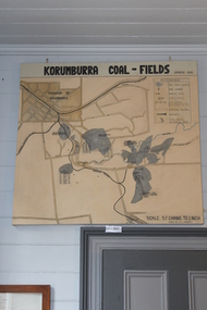
Map of Korumburra's Coal, Korumburra Coal Fields, 1910
... Korumburra Coal Fields...8513.1 - Map of coal fields, township, roads, creeks, railways and boreholes in the Korumburra area. ...Painted on Canvas Korumburra Coal Fields Map of Korumburra's Coal ...8513.1 - Map of coal fields, township, roads, creeks, railways and boreholes in the Korumburra area. Painted on Canvas -
 Coal Creek Community Park & Museum
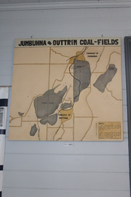
Jumbunna Coal Field Map, Jumbunna and Outtrim Coal Fields, 1910
... Jumbunna Coal Field Map...Jumbunna and Outtrim Coal Fields...8512.1 - Map of coal fields, Township, roads rail lines and creeks in the Jumbunna and Outtrim areas. ...Jumbunna and Outtrim Coal Fields Jumbunna Coal Field Map ...8512.1 - Map of coal fields, Township, roads rail lines and creeks in the Jumbunna and Outtrim areas. Painted on canvas. -
 Puffing Billy Railway
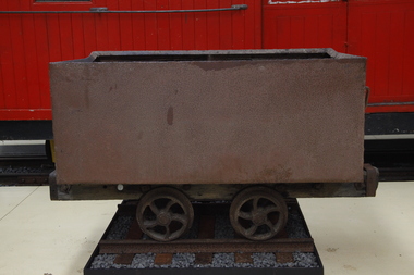
Wonthaggi Coal Skip, Early 20th century
... ...wonthaggi coal fields...One of two types of four wheel skips widely used on the Wonthaggi Coal Fields for transportation from the underground workings to the surface screening and loading areas. ...Historic - Industrial - Victorian Railways - Narrow Gauge Railway rolling stock - Wonthaggi Coal Fields, Victoria, Australia puffing billy coal skip wonthaggi wonthaggi coal fields 2'0" gauge brown coal Rectangular steel bin with wood frame and steel wheels Wonthaggi Coal Skip ...One of two types of four wheel skips widely used on the Wonthaggi Coal Fields for transportation from the underground workings to the surface screening and loading areas. Haulage underground was accomplished by the use of pit ponies, whilst an endless rope system was used to bring the skips to the surface areas. Much of the coal for the colony of Victoria was sourced from Newcastle and the Hunter Region in New South Wales, along with local supplies from private and co-operative coal mines at Outtrim, Jumbunna and Korumburra in Gippsland. After the 1909–1910 strike by coal miners in the Hunter Valley, the Victorian state government were determined to ensure stability in local supplies of coal. The State Coal Mine and the town of Wonthaggi came into being in 1910 to supply coal for the Victorian Railways. It was one of the largest and most dangerous collieries in Australia. At its peak in 1926 the mine produced 2,435 long tons (2,474 t) per day, with the Victorian Railways buying 90% of production. In 1928, Wonthaggi coal accounted for around 60% of Victorian Railways coal consumption.Historic - Industrial - Victorian Railways - Narrow Gauge Railway rolling stock - Wonthaggi Coal Fields, Victoria, AustraliaRectangular steel bin with wood frame and steel wheelspuffing billy, coal skip, wonthaggi, wonthaggi coal fields, 2'0" gauge, brown coal -
 Bendigo Historical Society Inc.
Document - BROADCASTING STATION 3CV, MARYBOROUGH, 2 March, 1956
... Primary production railway staff. Coal fields Wonthaggi. 1917 a public meeting was convened in an effort to stem the tide of adversity. ...Maryborough a little town without a future. Coal fields at Wonthaggi. 1917 a public meeting was convened in an effort to stem the tide of adversity. ...Primary production railway staff. Coal fields Wonthaggi. 1917 a public meeting was convened in an effort to stem the tide of adversity. ...Broadcasting Station 3CV, Maryborough. A souvenir of the opening of the New Studios and Offices of Central Victoria Broadcasters Pty Ltd. March 2nd, 1956. Established 1956, offices in Burke Street, opening coincides with the stations 21st birthday, March 2 for the former celebration, October 26 for the latter. Coverage included Bendigo, Ballarat, Daylesford, Castlemaine and Maryborough. 3CV plays active part in assisting charities and hospitals at Maryborough, Daylesford, Maldon and Dunolly. Active Women's Radio Club with branches in country centres adds strength to station's charitable efforts. Opening 3CV's new premises will widen the scope of the station's charitable efforts, and stronger link with Australian Commercial Broadcasting stations. Writer Harold V Nunn writes history of district of Mayborough. Manager Ken J Parker, Central Victoria Broadcasters Pty. Ltd. The Souvenir brochure also covers topics such as: deep lead mining. WWI. Houses being pulled down. New settlements of Mildura. Secondary Industries. Bowenvale, Alma, Majorca, Craigie, Amherst, Adelaide Lead, Havelock, Bet Bet, Bently. Primary production and a railway staff of approximately 150. Maryborough a little town without a future. Coal fields at Wonthaggi. 1917 a public meeting was convened in an effort to stem the tide of adversity. Mayor George Frost, M.L.A., decision to form a Progress Association, a policy of secondary industry was decided upon and committees were appointed, James L Drew much credit is due. Maryborough's move for rejuvenation was revolutionary, because apart from Ballarat, Bendigo and Geelong, it was regarded as so much presumption that industry could be expected to function with success in a country town. Governments were unsympathetic. Maryborough & district people showed determination to succeed and their faith in their town. Employment and economic security provided by the industries outweighed the debt. Maryborough's general position is that it is no longer dependent upon one particular phase of activity. The first of the industries to be formed in 1918 was the Butter Factory. The nearer dairy companies did not take kindly to the prospect of another opposition company taking supplies from their districts, and in the first few years of establishment completion made the going hard for the management. But adopting a conservative policy and placing all profits to reserve I the first six years of operation headway was gradually made. Thus it was a red letter day for the company in 1925 when the first dividend of 5 percent was paid.1955 dividend of 10 per cent. Operating it's own trucks the dairy serviced local dairymen up to 40 miles. Maryborough Knitting mills est. 1923, having transferred from Clunes. Out bid Ballarat and Bendigo to the industry. The mill has what is probably the largest circular underwear plant in the Commonwealth, which is conservatively valued at 198,913 pounds. It produces between four and five million garments each year, worth over one million pounds. The company has established subsidiary mills at Dunolly, Talbot and Avoca. The company also assisted in the establishment of the Interknit Hosiery Co. Ltd., Clunes. The Maryborough Flour Mills is the second oldest of Mayborough's industries. It was built by Mr Cadwallader over 70 years ago. It was later sold to Mr. A Land and then to Jas. Minifie & Co. It had a somewhat 'in-and -out' existence until purchased in 1923 by Messrs. Willersdorf and Forbes, of Eddington. In 1939 the firm began to build silos for the storage of bulk wheat and the present storage capacity is 100,000 bushels. 1944 power was changed from steam to electricity. The mill has an out put of 20 sacks an hour. 1938 a chaff mill was built, and now is regarded as one of the best in Victoria. Its output in one year of approximately 6,800 tons is a State record for a single cutter. During this 30 year period Patience and Nicholson Limited has grown with Maryborough and is now one of the major key industries of Australia. The P&N brand covers precision tools - taps, dies and twist drills - indispensable to the country's economy, and quality is acknowledged equally by an air craft factory in Canada, a dockyard in Thailand, a railway workshop in New Zealand, no less than by our own Australian industries. Maryborough can be proud of the part played by P&N in war when, geared to the needs of the times, it poured countless millions of tools into defence factories and to the armed forces of the Allies, and now in peace when it is providing, hydro-electric undertakings and the manufacture of cars and tractors. From 1858, W Phelan & Sons Pty Ltd has made phenomenal and spectacular growth, becoming incorporated as a private company in 1929. It is without doubt the greatest private development in the history of Maryborough. 1940 joinery manufacture was commenced. The company entered the Ready Built Housing field in `950 - and in 1951 established a factory at Cairns, Northern Queensland to overcome the manufacturing difficulties being experienced due to the shortage of plywood in Victoria. Present activities include: Ready Built Housing Factory, on-site building, a modern joinery, timber yard, drying kilns, etc., and plumbing & electrical & engineering services, a door and panel factory at Cairns, retail hardware store, Melbourne Sales Depot. Hedges & Bell Pty Ltd were est 1945, with a staff of 40 employees are the largest printing firm outside the metropolitan area. The branch of Premier Wireworks is a contribution made by the decentralisation policy of the State.event, official, celebration, broadcasting station 3cv, maryborough. a souvenir of the opening of the new studios and offices of central victoria broadcasters pty ltd. march 2nd, 1956. established 1956, offices in burke street, 21st birthday. coverage bendigo, ballarat, daylesford, castlemaine maryborough. assisting charities and hospitals maldon and dunolly. women's radio club opening 3cv's new premises australian commercial broadcasting stations. writer harold v nunn writes history of district of mayborough. manager ken j parker, central victoria broadcasters pty. ltd. souvenir brochure: deep lead mining. wwi. houses pulled down. new settlements. primary production railway staff. coal fields wonthaggi. 1917 a public meeting was convened in an effort to stem the tide of adversity. mayor george frost, m.l.a., form a progress association, policy of secondary industry, james l drew rejuvenation was revolutionary, employment and economic security. the first of the industries to be formed in 1918 was the butter factory. thus it was a red letter day for the company in 1925 when the first dividend of 5 percent was paid.1955 dividend of 10 per cent. operating it's own trucks serviced local dairymen. maryborough knitting mills est. 1923 largest circular underwear plant in the commonwealth. established subsidiary mills at dunolly, talbot, avoca. interknit hosiery co. ltd., clunes. the maryborough flour mills it was built by mr cadwallader. mr. a land jas. minifie & co. messrs. willersdorf and forbes, build silos for wheat storage capacity is 100, 000 bushels. 1944 power was changed from steam to electricity. 20 sacks an hour. 1938 a chaff mill was built, best in victoria. patience and nicholson limited the p&n precision tools - taps, dies and twist drills. war, geared to the needs of the times, countless millions of tools into defence factories the armed forces of the allies, hydro-electric undertakings and the manufacture of cars and tractors. from 1858, w phelan & sons pty ltd, incorporated 1929. 1940 joinery manufacture. ready built housing field in 1950 - 1951 established a factory at cairns, northern queensland to overcome the manufacturing difficulties being experienced due to the shortage of plywood in victoria. present activities: ready built housing factory, on-site building, a modern joinery, timber yard, drying kilns, etc., and plumbing & electrical & engineering services, a door and panel factory at cairns, retail hardware store, melbourne sales depot. hedges & bell pty ltd were est. 1945, with a staff of 40 employees are the largest printing firm outside the metropolitan area. the branch of premier wireworks is a contribution made by the decentralisation policy of the state. -
 Federation University Historical Collection
Book, Geological Gossip or Stray Chapters on Earth and Ocean, 1860, 1860
... ...coal fields...Barker Library (top floor) Mount Helen goldfields geology water rivers the atlantic great deep africa australian interior eyre's expedition murray river darling river earthqaukes leichardt moreton bay volcanos darwin's theory evolution egyptian race human remains in caverns and gravel rocks metamorphism iron ores coal coal fields gold deposits california water-glass artificial stone porous stones cements Brown hard covered book Brown hard covered book. ...Brown hard covered book. Chapter 16 is on gold deposits and discusses the discovery of gold in California and Australia.Brown hard covered book geology, water, rivers, the atlantic, great deep, africa, australian interior, eyre's expedition, murray river, darling river, earthqaukes, leichardt, moreton bay, volcanos, darwin's theory, evolution, egyptian race, human remains in caverns and gravel, rocks, metamorphism, iron ores, coal, coal fields, gold deposits, california, water-glass, artificial stone, porous stones, cements -
 Federation University Art Collection
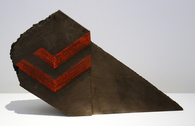
Ceramic - Artwork - Ceramics, Alan Watt, 'Blackfired Form' by Alan Watt, c1985, c1985
... The sculptural form is inspired by the cuts in open cut coal fields. ...The sculptural form is inspired by the cuts in open cut coal fields. 'Blackfired Form' by Alan Watt, c1985 Ceramic Artwork - Ceramics Alan Watt ...Alan WATT (1941- ) Born Melbourne, Victoria Alan Watt studied at RMIT from 1961 to 1965, and he completed a Fellowship Diploma in 1973-4. Alan Watt travelled and studied pottery in Europe and Japan, and lectured in three State a Colleges in Victoria since 1964. in 1984 Alan Watt was a guest lecturer at Spotkanie held at the Gippsland Campus of Advanced Education.Slab built blackfired stoneware. The sculptural form is inspired by the cuts in open cut coal fields. alan watt, ceramics, jan feder memorial ceramics collection, gippsland campus, spotkanie, strezlecki spotkanie -
 Coal Creek Community Park & Museum
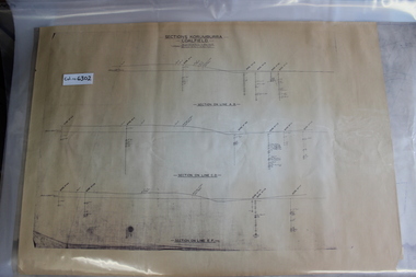
Mine Map
... 6302.1 - 3 cross sections through the Korumburra coal field area, showing topography, surface features, boreholes and elevation. ...Coal Creek Community Park & Museum 12 Silkstone Road Korumburra gippsland 6302.1 - 3 cross sections through the Korumburra coal field area, showing topography, surface features, boreholes and elevation. ...6302.1 - 3 cross sections through the Korumburra coal field area, showing topography, surface features, boreholes and elevation. Seems to be a copy of original. -
Lakes Entrance Historical Society
Book, Vines, Jack, Coal Mining Heritage Study, 2008
... A comprehensive study of black and brown coal mining in Victoria, from earliest discovery of coal deposits in Australia, to the vast coal fields of the Latrobe Valley, Victoria, where extraction is by open cut engineering....Lakes Entrance Historical Society 4 Marine Parade Lakes Entrance gippsland Engineering Mines and Mining A comprehensive study of black and brown coal mining in Victoria, from earliest discovery of coal deposits in Australia, to the vast coal fields of the Latrobe Valley, Victoria, where extraction is by open cut engineering. ...A comprehensive study of black and brown coal mining in Victoria, from earliest discovery of coal deposits in Australia, to the vast coal fields of the Latrobe Valley, Victoria, where extraction is by open cut engineering.engineering, mines and mining -
 Bendigo Historical Society Inc.
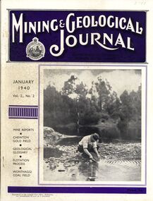
Book - MINING & GEOLOGICAL JOURNAL, 1940
... Mining & Geological Journal January 1940 Vol.2 No.2 Mine reports Chewton Gold Field, Geological Glossary, Flotation Process, Wonthaggi Coal Field published hald yearly by he Department of Mines Victoria contains photographs, maps and illustrations....History House 11 Mackenzie Street Bendigo goldfields GOLD Mining journal Mining & Geological Journal January 1940 Vol.2 No.2 Mine reports Chewton Gold Field, Geological Glossary, Flotation Process, Wonthaggi Coal Field published hald yearly by he Department of Mines Victoria contains photographs, maps and illustrations. ...Mining & Geological Journal January 1940 Vol.2 No.2 Mine reports Chewton Gold Field, Geological Glossary, Flotation Process, Wonthaggi Coal Field published hald yearly by he Department of Mines Victoria contains photographs, maps and illustrations.gold, mining, journal -
Phillip Island and District Historical Society Inc.
Reports, c 1890
... Report of Board appointed to enquire into the claims of Richard Davis of Cape Paterson to the reward of £1,000 offered by the Government in the year 1952 to the discoverer of "an available coal field" in the colony of Victoria....Phillip Island and District Historical Society Inc. phillip-island-and-the-bass-coast Report of Board appointed to enquire into the claims of Richard Davis of Cape Paterson to the reward of £1,000 offered by the Government in the year 1952 to the discoverer of "an available coal field" in the colony of Victoria. Local History DOCUMENTS Reports Coal Mines Westernport Coal Black and white type print. ...Report of Board appointed to enquire into the claims of Richard Davis of Cape Paterson to the reward of £1,000 offered by the Government in the year 1952 to the discoverer of "an available coal field" in the colony of Victoria.Report - Richard Davis and the first Western port coal.local history, documents, reports, coal mines, westernport coal, black and white type print., miss elms san remo, richard davis -
 Bendigo Historical Society Inc.
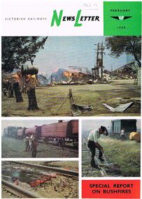
Document - BADHAM COLLECTION: NEWSLETTER FEBRUARY1969 SPECIAL REPORT ON BUSHFIRES
... Victorian Railways Newsletter / photos of effects of the fire to VR property/ closure of State coal mines / photos of fire destroyed bridge at Diamond Creek / Molesworth/ the Powlett River Coal Field in 1910 ( Wonthaggi) / Kirrak Mine / Printed at the Victorian railways printing works Laurens St North Melbourne...The contents include photos of effects of the fire to VR property, closure of State coal mines, photos of fire destroyed bridge at Diamond Creek, Molesworth, the Powlett River Coal Field in 1910 (Wonthaggi), and Kirrak Mine. ...The contents include photos of effects of the fire to VR property, closure of State coal mines, photos of fire destroyed bridge at Diamond Creek, Molesworth, the Powlett River Coal Field in 1910 (Wonthaggi), and Kirrak Mine. ...Victorian Railways Newsletter February 1969 Special report on bushfires. Glossy paper with colour photos on front of bushfires in relation to railway property. The contents include photos of effects of the fire to VR property, closure of State coal mines, photos of fire destroyed bridge at Diamond Creek, Molesworth, the Powlett River Coal Field in 1910 (Wonthaggi), and Kirrak Mine. Printed at the Victorian railways printing works Laurens St North Melbourne.magazine, government, victorian railways, victorian railways newsletter / photos of effects of the fire to vr property/ closure of state coal mines / photos of fire destroyed bridge at diamond creek / molesworth/ the powlett river coal field in 1910 ( wonthaggi) / kirrak mine / printed at the victorian railways printing works laurens st north melbourne -
 Federation University Historical Collection
Book, Sudtralasian Institute of Mining and Metallurgy, Latrobe Valley Brown Coal Resources: Geology, Exploration and Open Cut Mining Methods, 1960, 1960
... Block Prints on white pages, and sections of the Yallourn-Morwell field and the Yallourn Coal Field Includes the following chapters: * Contribution of the Minerals Industry to the Development of Australia by G.R. ... and the Yallourn Coal Field Includes the following chapters: * Contribution of the Minerals Industry to the Development of Australia by G.R. ...Red hard covered book. Block Prints on white pages, and sections of the Yallourn-Morwell field and the Yallourn Coal Field Includes the following chapters: * Contribution of the Minerals Industry to the Development of Australia by G.R. Fisher (including Gold, Broken Hill Field, Coal, Copper, Tin) * PLanning and Development of the Brown Coal Open Cuts of the State Electricity Commission of Victoria by E.D.J. Stewart * Geology of the Latrobe Valley Coalfield by C.S. Gloe * Developments in Equipment USed for Overburden Removal and Coal Winning in the Brown Coal Industry by H.C.G. Rodgers / J.M. Alexander * Development of Methods for Use of Punch Cards in the Recording of Drill Clogs in the Exploration for Brown Coal by H.E.C. Beernon-fictionyallourn, morwell, loy yang, brown coal, latrobe valley, aus imm, australian institute of mining and metallurgy, ausimm -
 Warrnambool and District Historical Society Inc.
Book, Star Printing Service Pty Ltd, Dear Adam and Jasmine, 2015
... coal production and the use of nuclear power for peaceful purposes and for defence are proposed. The book has been written for, and is dedicated to, the author’s grandchildren. This book is retained as it was written by Graham Keith, a local Warrnambool resident who has had considerable experience in the engineering field. ...This is a book detailing the environmental problems facing the world.This is a soft cover book of 158 pages. It has a blue cover with black printing on the front and a colour photograph of two children on the back. The book has 18 chapters of text and an index. The book contains some black and white photographs and a sketch. non-fictionThis is a book detailing the environmental problems facing the world.environmental issues, warrnambool -
 Bendigo Military Museum
Photograph - Royal Australian Survey Corps Surveyors in the Field – Northern Territory and Queensland, 1959 – 1960
... Seen in the photo placing a lid with hot coals onto the camp oven. Royal Australian Survey Corps Surveyors in the Field – Northern Territory and Queensland Photograph Royal Australian Survey Corps Surveyors in the Field – Northern Territory and Queensland Army Survey Regiment, Bendigo ...This is a set of 10 photographs of surveyors and support staff in the field undertaking duties in the Northern Territory and North Queensland in 1959 – 1960. The surveyors were employed in the establishment of mapping and geodetic control. In this era surveyors used theodolites to observe horizontal and vertical angles and tellurometers to measure base line distances between survey stations. Laplace survey observations seen in Photo .1P was a series of precise observations carried out at geodetic survey stations to determine astronomic latitudes, longitudes and azimuths to achieve maximum precision in the survey network. Laplace observations were necessary in a geodetic network at every 6th survey station, however the National Mapping Council specified at this time the spacing would be ideally between 4-6 survey stations. The cairn shown in photo .4P was built by RASvy as a landmark over a trigonometric survey station. It was dismantled in 1960 to enable re-occupation and survey observations. It was not restored to the condition shown in the photo.This is a set of 10 photographs of surveyors and support staff in the field undertaking duties in the Northern Territory (NT) and Queensland (QLD) in 1959 – 1960. The photographs were printed on photographic paper and are part of the Army Survey Regiment’s Collection. The photographs were scanned at 300 dpi. .1) - Photo, colour, 1959. Tony Slattery occupying a Laplace survey station on a hill in the Mount Young area of the NT. .2) - Photo, colour, 1959. Surveyors’ camp in the Mount Young area of the NT, L to R: Spencer Snow and Tony Slattery. .3) - Photo, colour, 1959. Surveyors’ camp in the Peckman Hill area, near Katherine in the NT. .4) - Photo, colour, 1959. Cairn on Trig Hill, Borroloola, NT. Built by Spencer Snow, Tom Royle and Jack McCabe. .5) - Photo, colour, 1959. Survey party taking a break next to their Austin Champ vehicle, in transit between Katherine, NT and Wyndam WA. L to R: Tony Slattery, Dave Owens, John Van De Graff. .6) - Photo, colour, 1960. Surveyors’ camp between Mount Isa, QLD and Borroloola, NT. L to R: Pat Cox and John Van De Graff prepare their meal on an open fire. .7) - Photo, colour, 1960. Surveyor - Dennis Woods undertaking survey observations, using MRA1 tellurometer to measure base-line distances NW of Mount Isa, QLD. .8) - Photo, colour, 1960. Unidentified surveyors assessing recovery of their stalled Studebaker truck vehicle after attempting a water crossing in the NT. .9) - Photo, colour, 1960. Unidentified surveyor making batches of bread at a camp in the NT. Seen in the photo placing a lid with hot coals onto the camp oven. .10) - Photo, colour, 1960. Unidentified survey party occupying a survey station on a hill in the Mount near the Lawn Hill area, NW of Mount Isa, QLD. A MRA1 tellurometer to measure base-line distances appear on the right side of the photo. .9) - Photo, colour, 1960. Unidentified surveyors assessing recovery of their stalled Studebaker truck vehicle after attempting a water crossing in the NT. .10) - Photo, colour, 1960. Unidentified surveyor making batches of bread at a camp in the NT. Seen in the photo placing a lid with hot coals onto the camp oven. .1P to .10P annotated on back – personnel names, the year and the location. royal australian survey corps, rasvy, army survey regiment, asr, army svy regt, fortuna, surveying -
 Kiewa Valley Historical Society
Photograph - Folder of Photographs (KVHS 1150 A - F) – Photocopied set of black and white photographs from the display folder (pages 1 - 8) put together by KVHS to document life on the Kiewa Valley Hydro-electric Scheme
... As part of the push to cut electricity costs and diversify supply, the Victorian Government (circa 1930) initiated the conversion from primarily brown coal supply to hydro – electricity. Field investigations during the 1940’s resulted in a new proposal for a scheme that had more than double the capacity of the 1938 scheme. ...As part of the push to cut electricity costs and diversify supply, the Victorian Government (circa 1930) initiated the conversion from primarily brown coal supply to hydro – electricity. Field investigations during the 1940’s resulted in a new proposal for a scheme that had more than double the capacity of the 1938 scheme. ...Although the Kiewa Hydro-Electric Scheme was first proposed in 1911, construction did not commence until 1938. As part of the push to cut electricity costs and diversify supply, the Victorian Government (circa 1930) initiated the conversion from primarily brown coal supply to hydro – electricity. Field investigations during the 1940’s resulted in a new proposal for a scheme that had more than double the capacity of the 1938 scheme. The Kiewa Hydroelectric Scheme became the largest scheme of its kind in the State Of Victoria and the second largest scheme in Australia. The number of personnel involved in the planning and construction of the scheme increased dramatically. During the late 1940’s, most activity centred around the construction of the West Kiewa Power Station, Rocky Valley Reservoir, McKay Creek Power Station and the Bogong Creek Aqueduct.A common thread across all the larger hydro scheme constructions was the need for workers, both qualified and unqualified who came from around the world seeking a new life for themselves and their families. New accommodation and facilities were required for the army of workers engaged in construction in often remote and wild areas. The SEC had a high demand for timber, and set up the first of a number of sawmills at Bogong Creek in 1939 and set up the first hardwood logging in the headwaters of the Kiewa River. These new ‘towns’ such as Mt Beauty and Bogong, survived, serving the needs of operational personnel and their families, and expanding with growth of new industries. Mount Beauty, and to a lesser extent Bogong, are among these places. Large A3 size spiral bound display folder containing 21 of 58 pages of photocopied black and white photographs of various aspects of the early days of the Kiewa Valley Hydro-electric scheme including equipment, various work sites and photographs of workers and their families. 1-Front page; 2-Security gate at Mt Beauty Camp; 3-Channel 1 on East Kiewa River; 4-Junction Dam – Diversion Tunnel Inlet; 5-Sawmill; 6- Homan’s Gap Sawmill; 7 Junction Dam: 8-Homan Dam Site-Diamond Drilling on River Buttress; 9- Homan Dam Site View Upstream 10-Homan Dam Investigation Camp 1-Windsor & Newton Visual Diary 60 sheet (120 pages) 11’ x 14’ 280 x 356mm 110 GSM Acid Free Drawing Paper 2-1940-Security Gate on Mt Beauty side of Kiewa River bridge. Part of old Mt Beauty camp and mess in background 3- STATE ELECTRICITY COMMISSION OF VICTORIA Date; 11.3.40 Time: 10.30am No K35 Kiewa Hydro Electric Works. Diverting East Kiewa River into Channel Page number 1 4-STATE ELECTRICITY COMMISSION OF VICTORIA Date: 5.4.40 Time: Noon No K58 Kiewa Hydro Electric Works. Junction Dam – Diversion Tunnel Inlet – Normal Flow Page number 2 5- STATE ELECTRICITY COMMISSION OF VICTORIA Date: 19.8.42 Time: 2.30pm No K883 Kiewa Hydro Electric Works. Sawmill – General View Page number 3 6- STATE ELECTRICITY COMMISSION OF VICTORIA Date: 12.1.42 Time: 2.00pm No K540 Kiewa Hydro Electric Works. Homan’s Gap Sawmill – General View Page number 4 7- STATE ELECTRICITY COMMISSION OF VICTORIA Date: 12.1.42 Time: 2.00pm No K540 Kiewa Hydro Electric Works. Junction Dam – General View looking upstream Page number 5 8- STATE ELECTRICITY COMMISSION OF VICTORIA Date: 16.11.45 Time: 10.32amm No K52153 Kiewa Hydro Electric Works Homan Dam Site – Diamond Drilling on River Buttress Page number 6 9-STATE ELECTRICITY COMMISSION OF VICTORIA Date: 15.1.45 Time: 4.10pm No K1781 Kiewa Hydro Electric Works Homan Dam Site – View Upstream Page number 7 10- STATE ELECTRICITY COMMISSION OF VICTORIA Date: 15.1.45 Time: 4.10pm No K1781 Kiewa Hydro Electric Works Homan Dam Investigation Camp 1944 – 1945 Page number 8 secv; kiewa hydro electric scheme; mt beauty; bogong; construction work; -
 Kiewa Valley Historical Society
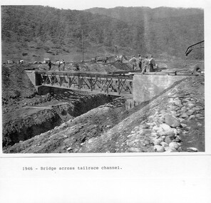
Photograph - Folder of Photographs – Photocopied set of black and white photographs (pages 9 - 18) from the display folder put together by KVHS to document life on the Kiewa Valley Hydro-electric Scheme
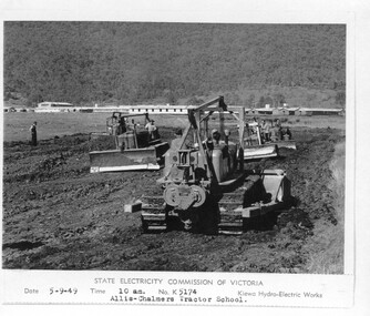
... As part of the push to cut electricity costs and diversify supply, the Victorian Government (circa 1930) initiated the conversion from primarily brown coal supply to hydro – electricity. Field investigations during the 1940’s resulted in a new proposal for a scheme that had more than double the capacity of the 1938 scheme. ...As part of the push to cut electricity costs and diversify supply, the Victorian Government (circa 1930) initiated the conversion from primarily brown coal supply to hydro – electricity. Field investigations during the 1940’s resulted in a new proposal for a scheme that had more than double the capacity of the 1938 scheme. ...Although the Kiewa Hydro-Electric Scheme was first proposed in 1911, construction did not commence until 1938. As part of the push to cut electricity costs and diversify supply, the Victorian Government (circa 1930) initiated the conversion from primarily brown coal supply to hydro – electricity. Field investigations during the 1940’s resulted in a new proposal for a scheme that had more than double the capacity of the 1938 scheme. The Kiewa Hydroelectric Scheme became the largest scheme of its kind in the State Of Victoria and the second largest scheme in Australia. The number of personnel involved in the planning and construction of the scheme increased dramatically. During the late 1940’s, most activity centred around the construction of the West Kiewa Power Station, Rocky Valley Reservoir, McKay Creek Power Station and the Bogong Creek Aqueduct.A common thread across all the larger hydro scheme constructions was the need for workers, both qualified and unqualified who came from around the world seeking a new life for themselves and their families. New accommodation and facilities were required for the army of workers engaged in construction in often remote and wild areas. The SEC had a high demand for timber, and set up the first of a number of sawmills at Bogong Creek in 1939 and set up the first hardwood logging in the headwaters of the Kiewa River. These new ‘towns’ such as Mt Beauty and Bogong, survived, serving the needs of operational personnel and their families, and expanding with growth of new industries. Mount Beauty, and to a lesser extent Bogong, are among these places. PHYSICAL: Large A3 size spiral bound display folder containing 21 pages of photocopied black and white photographs of various aspects of the early days of the Kiewa Valley Hydro-electric scheme including equipment, various work sites and photographs of workers and their families. 1-Bridge across Tailrace Channel 1946 2-New Mess building, Mt Beauty 3-Homan’s Gap Saw Mill 4- Diamond Drilling Plant – Big Hill 5-Rocky Valley Camp-Mess Building 6-Parlimentary Party at Rocky Valley 7-No.4 Headrace Tunnel 8- Allis-Chalmers Tractor School 9- SECV Heavy Machinery lined up by road 10- No. 5 Raceline – Balasting Track with improvised truck 1-1946 – Bridge across tailrace channel Page number 9 2-New mess building, Mt Beauty 6.4.46 Page number 10 3- STATE ELECTRICITY COMMISSION OF VICTORIA Date: 10.1.47 Time: 11.40am No K2271 Kiewa Hydro Electric Works Homan’s Gap Saw Mill – Rip Saw Page number 11 4- STATE ELECTRICITY COMMISSION OF VICTORIA Date: 5.10.47 Time: 11am No K4111 Kiewa Hydro Electric Works Diamond Drilling Plant – Big Hill Page number 12 5- STATE ELECTRICITY COMMISSION OF VICTORIA Date: 11.2.48 Time: 3pm No K4277 Kiewa Hydro Electric Works Rocky Valley Camp-Mess Building Page number 13 6- STATE ELECTRICITY COMMISSION OF VICTORIA Date: 15.4.48 Time: 4.30pm No K4397 Kiewa Hydro Electric Works Parlimentary Party at Rocky Valley Page number 14 7- STATE ELECTRICITY COMMISSION OF VICTORIA Date: 22.8.48 Time: 9am No K4668 Kiewa Hydro Electric Works General view of No.4 Headrace Tunnel Page number 15 8-STATE ELECTRICITY COMMISSION OF VICTORIA Date: 5.9.49 Time: 10am No K5180 Kiewa Hydro Electric Works Allis-Chalmers Tractor School – HD 19, Mr I Crossthwaite at Controls Page number 16 9- No markings Page number 17 10- STATE ELECTRICITY COMMISSION OF VICTORIA Date: 7,12.49 Time: 4pm No K5423 Kiewa Hydro Electric Works No. 5 Raceline – Balasting Track with improvised truck. Page number 18 secv; kiewa hydro electric scheme; mt beauty; bogong; construction area -
 Kiewa Valley Historical Society
Photograph - Folder of Photographs – Photocopied set of 10 black and white photographs (pages 19 - 28) from the display folder put together by KVHS to document life on the Kiewa Valley Hydro-electric Scheme
... As part of the push to cut electricity costs and diversify supply, the Victorian Government (circa 1930) initiated the conversion from primarily brown coal supply to hydro – electricity. Field investigations during the 1940’s resulted in a new proposal for a scheme that had more than double the capacity of the 1938 scheme. ...As part of the push to cut electricity costs and diversify supply, the Victorian Government (circa 1930) initiated the conversion from primarily brown coal supply to hydro – electricity. Field investigations during the 1940’s resulted in a new proposal for a scheme that had more than double the capacity of the 1938 scheme. ...Although the Kiewa Hydro-Electric Scheme was first proposed in 1911, construction did not commence until 1938. As part of the push to cut electricity costs and diversify supply, the Victorian Government (circa 1930) initiated the conversion from primarily brown coal supply to hydro – electricity. Field investigations during the 1940’s resulted in a new proposal for a scheme that had more than double the capacity of the 1938 scheme. The Kiewa Hydroelectric Scheme became the largest scheme of its kind in the State Of Victoria and the second largest scheme in Australia. The number of personnel involved in the planning and construction of the scheme increased dramatically. During the late 1940’s, most activity centred around the construction of the West Kiewa Power Station, Rocky Valley Reservoir, McKay Creek Power Station and the Bogong Creek Aqueduct.A common thread across all the larger hydro scheme constructions was the need for workers, both qualified and unqualified who came from around the world seeking a new life for themselves and their families. New accommodation and facilities were required for the army of workers engaged in construction in often remote and wild areas. The SEC had a high demand for timber, and set up the first of a number of sawmills at Bogong Creek in 1939 and set up the first hardwood logging in the headwaters of the Kiewa River. These new ‘towns’ such as Mt Beauty and Bogong, survived, serving the needs of operational personnel and their families, and expanding with growth of new industries. Mount Beauty, and to a lesser extent Bogong, are among these places. Large A3 size spiral bound display folder containing 21 pages of photocopied black and white photographs of various aspects of the early days of the Kiewa Valley Hydro-electric scheme including equipment, various work sites and photographs of workers and their families. 1-Allis Chalmers Tractor School 2- Gardens outside Administrative Office – Mt Beauty 3- Mt Beauty house – 1950 4-Bridge over Pretty Valley River, Bogong 5-Rocky Valley Spillway Tunnel break through 6-Ni 1 Headrace Tunnel drilling face 7-No 4 Power Station Drilling 8-Clover Dam Flood Waters 9-No1 Head Race Tunnel Portal Building 10-Clover Dam 1-STATE ELECTRICITY COMMISSION OF VICTORIA Date: 5.9.49 Time: 10amm No K5174 Kiewa Hydro Electric Works Allis Chalmers Tractor School Page number 19 2-STATE ELECTRICITY COMMISSION OF VICTORIA Date: 22.2.50 Time: 3.30pm No K5601 Kiewa Hydro Electric Works Gardens outside Administrative Office – Mt Beauty Page number 20 3-Mt Beauty house – 1950 Page number 21 4-STATE ELECTRICITY COMMISSION OF VICTORIA Date: 23.10.50 Time: 11.15am No K6331 Kiewa Hydro Electric Works Bogong-Bridge over Pretty Valley River Page number 22 5-STATE ELECTRICITY COMMISSION OF VICTORIA Date: 23.6.50 Time: 2.30pm No K5844 Kiewa Hydro Electric Works ROCKY VALLEY SPILLWAY TUNNEL BREAK THROUGH Page number 23 6-20/3/52 – No. 1 Headrace Tunnel Drilling face (E.E.E. contract) Page number 24 7-6/6/52 – No 4 Power Station – Drilling Page number 25 8-STATE ELECTRICITY COMMISSION OF VICTORIA Date: 6/6/52 Time: No K7113 Kiewa Hydro Electric Works Clover Dam Flood Waters Page number 26 9-STATE ELECTRICITY COMMISSION OF VICTORIA Date: Oct 1952 Time: No K7239 Kiewa Hydro Electric Works No. 1 HEAD RACE TUNNEL PORTAL BUILDING. Handwritten underneath – This information from Ron White-the later Principal Hydro Engineer of the SEC. Oct 1952 Location incorrect? All work on No 1 had ceased after financial crash of 1951. This photo would refer to No 4 Headrace Tunnel? Page number 27 10-STATE ELECTRICITY COMMISSION OF VICTORIA Date: Jan 1953 Time: No K7307 Kiewa Hydro Electric Works CLOVER DAM Page number 28 secv; kiewa hydro electric scheme; bogong; mt beauty; construction area -
 Kiewa Valley Historical Society
Photograph - Folder of Photographs – Photocopied set of 10 black and white photographs (pages 29 - 38) from the display folder put together by KVHS to document life on the Kiewa Valley Hydro-electric Scheme
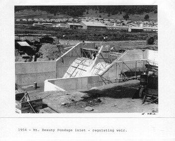
... As part of the push to cut electricity costs and diversify supply, the Victorian Government (circa 1930) initiated the conversion from primarily brown coal supply to hydro – electricity. Field investigations during the 1940’s resulted in a new proposal for a scheme that had more than double the capacity of the 1938 scheme. ...As part of the push to cut electricity costs and diversify supply, the Victorian Government (circa 1930) initiated the conversion from primarily brown coal supply to hydro – electricity. Field investigations during the 1940’s resulted in a new proposal for a scheme that had more than double the capacity of the 1938 scheme. ...Although the Kiewa Hydro-Electric Scheme was first proposed in 1911, construction did not commence until 1938. As part of the push to cut electricity costs and diversify supply, the Victorian Government (circa 1930) initiated the conversion from primarily brown coal supply to hydro – electricity. Field investigations during the 1940’s resulted in a new proposal for a scheme that had more than double the capacity of the 1938 scheme. The Kiewa Hydroelectric Scheme became the largest scheme of its kind in the State Of Victoria and the second largest scheme in Australia. The number of personnel involved in the planning and construction of the scheme increased dramatically. During the late 1940’s, most activity centred around the construction of the West Kiewa Power Station, Rocky Valley Reservoir, McKay Creek Power Station and the Bogong Creek Aqueduct.A common thread across all the larger hydro scheme constructions was the need for workers, both qualified and unqualified who came from around the world seeking a new life for themselves and their families. New accommodation and facilities were required for the army of workers engaged in construction in often remote and wild areas. The SEC had a high demand for timber, and set up the first of a number of sawmills at Bogong Creek in 1939 and set up the first hardwood logging in the headwaters of the Kiewa River. These new ‘towns’ such as Mt Beauty and Bogong, survived, serving the needs of operational personnel and their families, and expanding with growth of new industries. Mount Beauty, and to a lesser extent Bogong, are among these places. Large A3 size spiral bound display folder containing 21 pages of photocopied black and white photographs of various aspects of the early days of the Kiewa Valley Hydro-electric scheme including equipment, various work sites and photographs of workers and their families. 1-Mt Beauty Pondage inlet-Regulating weir 2-Langfords Gap Basalt Hill-Tunnel in quarry face.3-Rocky Valley Camp-from Engineering Office 4-Basalt Hill tunnel portal 5-No 1 Pressure Shaft Works Bench 6-No 1 Power Station 7-Overturned haulage wagons on the side of an embankment 8- Group of workers dressed in wet weather gear inside a tunnel 9-Workmen and vehicle in tunnel 10-Howman’s Gap campsite at 4,150 feet 1-1954 – Mt Beauty Pondage inlet – Regulating weir Page number 29 2-28/10/54 – Langfords Gap Basalt Hill – Tunnel in quarry face K7860 Page number 30 3-STATE ELECTRICITY COMMISSION OF VICTORIA Date: 17.8.55 Time: No K8132 Kiewa Hydro Electric Works ROCKY VALLEY CAMP – FROM ENGINEERING OFFICE Page number 31 4-28/10/54 – Basalt Hill tunnel portal K7859 Page number 32 5-No.1 Pressure Shaft Works Bench 5.7.56 Page number 33 6- No. 1 Power Station 26.4.59 Page number 34 7- No markings Page number 35 8-No markings (Wooden board on ground printed with - POLAR A.N.GELATINE DYNAMITE “75” DE 28.8.40) Page number 36 9-No markings Page number 37 10-Howman’s Gap campsite at 4,150 feet Page number 38 secv; kiewa hydro electric scheme; mt beauty; bogong; construction area -
 Kiewa Valley Historical Society
Photograph - Folder of Photographs – Photocopied set of black and white photographs (pages 49 -58) from the display folder put together by KVHS to document life on the Kiewa Valley Hydro-electric Scheme
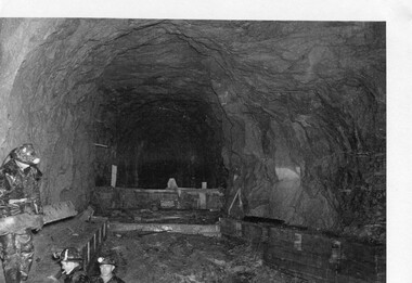
... As part of the push to cut electricity costs and diversify supply, the Victorian Government (circa 1930) initiated the conversion from primarily brown coal supply to hydro – electricity. Field investigations during the 1940’s resulted in a new proposal for a scheme that had more than double the capacity of the 1938 scheme. ...As part of the push to cut electricity costs and diversify supply, the Victorian Government (circa 1930) initiated the conversion from primarily brown coal supply to hydro – electricity. Field investigations during the 1940’s resulted in a new proposal for a scheme that had more than double the capacity of the 1938 scheme. ...Although the Kiewa Hydro-Electric Scheme was first proposed in 1911, construction did not commence until 1938. As part of the push to cut electricity costs and diversify supply, the Victorian Government (circa 1930) initiated the conversion from primarily brown coal supply to hydro – electricity. Field investigations during the 1940’s resulted in a new proposal for a scheme that had more than double the capacity of the 1938 scheme. The Kiewa Hydroelectric Scheme became the largest scheme of its kind in the State Of Victoria and the second largest scheme in Australia. The number of personnel involved in the planning and construction of the scheme increased dramatically. During the late 1940’s, most activity centred around the construction of the West Kiewa Power Station, Rocky Valley Reservoir, McKay Creek Power Station and the Bogong Creek Aqueduct.A common thread across all the larger hydro scheme constructions was the need for workers, both qualified and unqualified who came from around the world seeking a new life for themselves and their families. New accommodation and facilities were required for the army of workers engaged in construction in often remote and wild areas. The SEC had a high demand for timber, and set up the first of a number of sawmills at Bogong Creek in 1939 and set up the first hardwood logging in the headwaters of the Kiewa River. These new ‘towns’ such as Mt Beauty and Bogong, survived, serving the needs of operational personnel and their families, and expanding with growth of new industries. Mount Beauty, and to a lesser extent Bogong, are among these places. Large A3 size spiral bound display folder containing photocopied black and white photographs of various aspects of the early days of the Kiewa Valley Hydro-electric scheme including equipment, various work sites and photographs of workers and their families. 1-Workmen working inside one of the tunnels. 2-Workman drilling in West Kiewa Tunnel 3-Junction Dam wall construction 4&5-2B&W photographs Kiewa House residents ready to go to a ball in Mt Beauty 6-Workmen warming up in front of a fire at No 1 bench 7-Workmen being hauled in at No 4 P.S Shaft 8-No 4 Power Station – Drilling 9-Workmen eating a hot meal in the tunnel. 10-2 photographs (a)Pretty Valley camp showing workman’s huts and construction materials & (b)Worker in Langford Gap Basalt Hill Tunnel face 11-Tunnel entrance (unlabelled) with rail tracks in foreground 12- Workmen drilling at No 1 Head race tunnel-Drilling face 13- No 1 Power Station 14-Workmen at the entrance to one of the SECV tunnels under construction 1-SECV number at bottom of picture Half obscured possibly K8461 Page number 53 2-In West Kiewa Tunnel Page number 54 3- Construction of Junction Dam wall – approximately 1941 Page number 55 4&5- Residents of Kiewa House at Bogong ready to go to the ball at Mt Beauty-1946. Handwritten on a copy of the photo on opposite page Mrs Lorna Crosset filled out the names *Dad was Des Crossett – his daughter is Gael Petcopoulis Greta engaged to John broke it off. Charlie, Rosalind, Bill, Priscilla, Max Lawrence-Dad’s Boss, Mary & Max married, Mary, Kay, Gwen McPherson Mum’s boss, John McCluskey (c) At No. 5 Bench Page number 56 6- STATE ELECTRICITY COMMISSION OF VICTORIA Date: 27.2.51 Time:2.15pm No K6373 Kiewa Hydro Electric Works No. 4 P.S. Shaft – Haulage of men in buckets (b) As above Handwritten at top of photo Appendix 4 page number 57 7- STATE ELECTRICITY COMMISSION OF VICTORIA Date: 6.6.52 Time:… No K7122 Kiewa Hydro Electric Works No. 4 POWER STATION – DRILLING page number 58 8-No markings page number 59 9-(a)Handwritten under photograph Approx. 1948/49 (b) STATE ELECTRICITY COMMISSION OF VICTORIA Date: 28.10.54 Time:.. No K7860 Kiewa Hydro Electric Works LANGFORD GAP BASALT HILL TUNNEL FACE Page number 49 10-(a) No markings 11- STATE ELECTRICITY COMMISSION OF VICTORIA Date: 20.3.52 Time: No K6979 Kiewa Hydro Electric Works No. 1 HEAD RACE TUNNEL – DRILLING FACE (E.E.E. CONTRACT) ‘The Frenchies’ (E.E.E) as they were affectionately known Page number 50 12-31.5.56 No. 1 Power Station Aggregate Stock Piles. Page number 51 13&14-No markings Page number 52 secv; kiewa hydro electric scheme; bogong; mt beauty; construction area -
 Kiewa Valley Historical Society
Photograph - Folder of Photographs – Photocopied set of black and white photographs (pages 39 - 48) from the display folder put together by KVHS to document life on the Kiewa Valley Hydro-electric Scheme
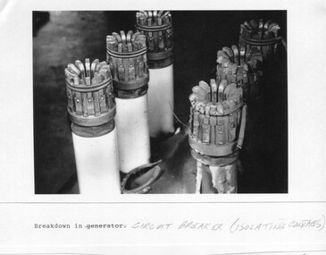
... As part of the push to cut electricity costs and diversify supply, the Victorian Government (circa 1930) initiated the conversion from primarily brown coal supply to hydro – electricity. Field investigations during the 1940’s resulted in a new proposal for a scheme that had more than double the capacity of the 1938 scheme. ...As part of the push to cut electricity costs and diversify supply, the Victorian Government (circa 1930) initiated the conversion from primarily brown coal supply to hydro – electricity. Field investigations during the 1940’s resulted in a new proposal for a scheme that had more than double the capacity of the 1938 scheme. ...Although the Kiewa Hydro-Electric Scheme was first proposed in 1911, construction did not commence until 1938. As part of the push to cut electricity costs and diversify supply, the Victorian Government (circa 1930) initiated the conversion from primarily brown coal supply to hydro – electricity. Field investigations during the 1940’s resulted in a new proposal for a scheme that had more than double the capacity of the 1938 scheme. The Kiewa Hydroelectric Scheme became the largest scheme of its kind in the State Of Victoria and the second largest scheme in Australia. The number of personnel involved in the planning and construction of the scheme increased dramatically. During the late 1940’s, most activity centered around the construction of the West Kiewa Power Station, Rocky Valley Reservoir, McKay Creek Power Station and the Bogong Creek Aqueduct.A common thread across all the larger hydro scheme constructions was the need for workers, both qualified and unqualified who came from around the world seeking a new life for themselves and their families. New accommodation and facilities were required for the army of workers engaged in construction in often remote and wild areas. The SEC had a high demand for timber, and set up the first of a number of sawmills at Bogong Creek in 1939 and set up the first hardwood logging in the headwaters of the Kiewa River. These new ‘towns’ such as Mt Beauty and Bogong, survived, serving the needs of operational personnel and their families, and expanding with growth of new industries. Mount Beauty, and to a lesser extent Bogong, are among these places. Large A3 size spiral bound display folder containing photocopied black and white photographs of various aspects of the early days of the Kiewa Valley Hydro-electric scheme including equipment, various work sites and photographs of workers and their families. 1-Breakdown in Circuit Breaker (Isolating Contacts) 2-Big Hill Bench- Site of No 5 Devlopment 3-No 1 Power Station 4-No 1 Pipeline, Anchor No 8 5-Push Dozing-RD8 Tractor 6- Tractor and driver at work 7- Workmen in unnamed tunnel 8- Front page of Journal of SECV Vol 15. Photograph of No 1 pipeline viewed from McKay Portal 9-Rocky Valley Dam Core Wall 10-Workmen working inside tunnel loading rocks into a rail truck. 1-Breakdown in (generator) Circuit Breaker (Isolating Contacts) Handwritten underneath (This is not a picture of any part of a generator. It is a circuit breaker Signed Ron White Ron was the Principal Hydro Engineer of the SEC Kiewa Scheme Page number 39 2-Big Hill Bench – Site of No. 5 Development (abandoned) Page number 40 3-No 1 Power Station Page number 41 4-No. 1 Pipeline, Anchor No. 8 Page number 42 5-Push Dozing – RD8 Tractor, 12 cubic yard Carryall and FD Cletrac Tractor Page number 43 6-No marking Page number 44 7-No marking Page number 45 8-Journal of State Electricity Commission of Victoria SEC Vol 15 No… April-May, 19… No 1 Pipeline-A view from McKay Portal G Hempenstall and D Sutton stiffening pipe section for transport during construction (….indicates missing text) Page Number 46 9-Rocky Valley Dam Core Wall Page number 47 10-No markings Page number 48 secv; kiewa hydro electric scheme; construction area; power stations; reservoirs; aqueduct; mt beauty; bogong -
 Kiewa Valley Historical Society
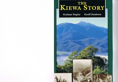
Book - Non Fiction History, The Kiewa Story, circa 1993
... coal fired power plants were increasing in numbers to service an ever increasing demand made by population expansion, especially in cities and large rural settlements. This demand spiraled up after World War II when there was a tremendous spike in immigration numbers due to refugees and displaced persons in Europe. The ability to utilise the untapped water provided by the winter snow fields...coal fired power plants were increasing in numbers to service an ever increasing demand made by population expansion, especially in cities and large rural settlements. This demand spiraled up after World War II when there was a tremendous spike in immigration numbers due to refugees and displaced persons in Europe. The ability to utilise the untapped water provided by the winter snow fields ...This book provides in chronological order the development of the Kiewa Hydro-electricity scheme from the first concept (1911) to final construction work (1961). It covers the first attempt to utilise the power of the Victorian Alps water system. It started from a private syndicate and developed to the current State Electricity Commission of Victoria. The incentive for the Hydro scheme was to make money and not as an alternative to the carbon producing coal fired power plants. These coal fired power plants were increasing in numbers to service an ever increasing demand made by population expansion, especially in cities and large rural settlements. This demand spiraled up after World War II when there was a tremendous spike in immigration numbers due to refugees and displaced persons in Europe. The ability to utilise the untapped water provided by the winter snow fields, for a higher yield in electricity, was a powerful incentive to overcome the physical hardships in this remote Alpine region. Future power requirements may initiate the re-installation of the other two power stations(Pretty Valley and Big Hill) covered in original Scheme. This publication not only covers the development of the Kiewa Valley region with respect to population (within a socio-economical framework) but also the subtle but yet strong physical changes of a relatively pristine alpine region. The demands that an ever growing regional population places on the environment is clearly documented in print and black and white photographs. The working and living conditions of those who constructed and gave life to this hydro scheme is well documented in this book. It may be viewed as spartan now but was relevantly good at that moment in time, especially for those workers fleeing a devastated European environment. The successful planning and consideration to minimising any intrusion upon the natural alpine forests and high plains can viewed as an example (compared to the Tasmanian Hydro schemes) of how future hydro schemes (an inevitable requirement) will proceed. Most rural towns (in the early 1900s) were built by unencumbered rural based citizens, with the exception of Mount Beauty and Falls Creek. These two settlements were brought into life by a State (Victorian) Authority for a specific function and program. They were a gated community, that is, only open to construction workers involved with the hydro scheme. All facilities within these communities were provided by the State Electricity Commission of Victoria. The impact on the social, financial and individual independency of the community, by the transition from the S.E.C .environment to one of local government (Shire of Bright), had in some cases a severe impact.This hard covered book has a green cover with pictures on the front and back covers. The front cover has a coloured picture of a snow covered Mount Bogong taken from the opposite mountain range. The valley between both ranges has a whisk of mist over it. At the bottom of this picture are three black and white photographs covering the construction of the Kiewa Hydro - Electricity Scheme. On the back cover is a photograph, (black and white) detailing the Bogong village and Junction dam containing lake Guy. The inside front cover is a black and white photograph which details the construction of the West Kiewa tailrace tunnel during April 1951. The inside back cover is a black and white photograph of the concrete pour at the Clover Dam circa 1952. All photographs and sketches are in black and white. The pages are approximately 160 g/m2 and those which have photographs are on gloss paper.Book spine: "The Kiewa Story Graham Napier Geoff Easdown" alongside this is a white framed circle with white spokes radiating out and underneath in white lettering SECkiewa valley, hydro scheme, victorian alpine region, electricity generators, graham napier, geoff easdown -
 Eltham District Historical Society Inc
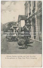
Photograph - Postcard, Chinese Coolies carrying coal from the ships to the godowns on Praya, East Point, Hongkong, c.1910s - c.1920s
... Fielding Collection Postcard Hongkong M. Sternberg Postcard. Originally contained in an accordian style album, they have been rehoused in archival safe photo album protectors as the album pages were torn and broken into multiple sections, held together with stickytape and staples Chinese Coolies carrying coal from the ships to the godowns on Praya, East Point, Hongkong Photograph Postcard ...Published by M. Sternberg, Wholesale and Retail Postcard Dealer at No. 51 Queen's Road Central and at No. 34 Queen's Road Central, Kongkong.This item, a souvenir from Hongkong from between the wars (circa 1923) was brought home to Research, Victoria by Bill Teagle who was serving in the Royal Australian Navy (1919-1945). According to Bill's neice Valerie Waller (nee Feldbauer, daughter of Violet and Theodore 'Curly' Feldbauer), her Uncle Bill would always bring some sort of souvenir home from his travels for family members. The item ( along with a series of postcards from Japan of the Great Kanto Earthquake of 1 September 1923) was possibly given by Bill Teagle to his sister Margaret Rose (formerly Ingram) who later married Richard Edward (Eddie) Fielding in early 1948. (Eddie had been engaged to someone else before he went to war, but his fiancée broke it off before his return to Australia.) It was cared for by the Teagle/Fielding family for approximately one hundred years. It is of particular significance given the family's connection to the Eltham War Memorial through 'Curly' Feldbauer and the significance of that memorial to the local community and represents that despite the horrors of war, former friends then foes can become friends again.tom fielding collection, postcard, hongkong, m. sternberg -
 Bendigo Historical Society Inc.
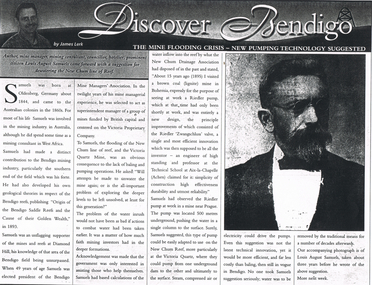
Newspaper - LONG GULLY HISTORY GROUP COLLECTION: THE MINE FLOODING CRISIS - NEW PUMPING TECHNOLOGY SUGGESTED
... field. He was president of the Mine Managers' Association. He believed the flooding was caused by the lack of baling and pumping operations. Earlier he had visited a coal...field. He was president of the Mine Managers' Association. He believed the flooding was caused by the lack of baling and pumping operations. Earlier he had visited a coal ...Copy of an article from the Bendigo Weekly 9/6/2000 titled The Mine Flooding Crisis - New Pumping Technology Suggested by James Lerk. Louis August Samuels was born in Germany. Samuels was involved in the mining industry in Australia and he had mining experience in West Africa. He had knowledge of the mines at the southern end of the field. He was president of the Mine Managers' Association. He believed the flooding was caused by the lack of baling and pumping operations. Earlier he had visited a coal mine in Bohemia to see a Riedler pump at work. It was a new design, very effective, simple in design and reliable. He watched it work. It was 500 metres underground and pushed the water to the surface in a single column. He suggested this type of pump could be adapted to use on the New Chum Reef. Even this suggestion was not the latest technical innovation, but it would be more efficient and less costly than baling. No one took him seriously and continued to remove water by the traditional means. Article is accompanied by a photo of Samuels.bendigo, history, long gully history group, the long gully history group - the mine flooding crisis - new pumping technology suggested, bendigo weekly 9/6/2000, james lerk, louis august samuels, origin of the bendigo saddle reefs and the cause of their golden wealth 1893, bendigo mine managers' association, victoria proprietary company, victoria quartz mine, new chum drainage association, riedler pump, riedler zwangschluss valve, technical school at aix-la-chapelle (achen) -
 The Beechworth Burke Museum
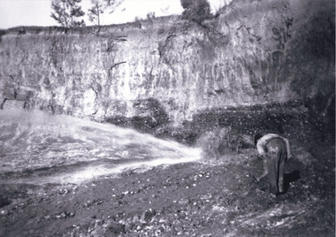
Photograph, c1920
... coal. This photograph shows the impact the gold rush era had on Australia and the earth. mining gold fields beechworth gold rush burke museum photograph mining cavity Hydraulic mining hydraulic sluicing Baarmutha Copied from original on loan film (WEBB QLD) / Donated 2009 NOV/ Baarmutha Three Mile Mine c1920-1950/ Managed by John Weir Peter Jereen Jack Cox / Owned by Plain Bros then Parkinsons Sluicing. ...This photo shows the large mining cavity with a hydraulic sluicing machine in operation at Baarmutha Three Mile Mine, Beechworth . The Beechworth Mining District was one of six mining districts established by the Governor-in-Council on 4 January 1858 under the provisions of An Act for Amending the Laws Relating to the Goldfields (21 Vic no.32). The District was further divided into seven divisions: Spring Creek, Snake Valley, Three Mile Creek, Buckland, Woolshed, Yackandandah and Omeo. The boundaries of each of these divisions and of the whole district are described in the Governor-in-Council's proclamation printed in the Government Gazette, 5 January 1858, pages 3-5. Hydraulic mining is a form of mining that uses high-pressure jets of water to dislodge rock material or move sediment. In the placer mining of gold or tin, the resulting water-sediment slurry is directed through sluice boxes to remove the gold. It is also used in mining kaolin and coal.This photograph shows the impact the gold rush era had on Australia and the earth.A black and white rectangular photograph printed on photographic paperCopied from original on loan film (WEBB QLD) / Donated 2009 NOV/ Baarmutha Three Mile Mine c1920-1950/ Managed by John Weir Peter Jereen Jack Cox / Owned by Plain Bros then Parkinsons Sluicing.mining, gold fields, beechworth, gold rush, burke museum, photograph, mining cavity, hydraulic mining, hydraulic sluicing, baarmutha -
Phillip Island and District Historical Society Inc.
Photograph, c 1900
... Coal tramway from Kilcunda to Griffiths Point - horses grazing in foreground. House and tree on left of photograph. White railway track winding through the fields which are overlooking the water....Phillip Island and District Historical Society Inc. phillip-island-and-the-bass-coast Coal tramway from Kilcunda to Griffiths Point - horses grazing in foreground. House and tree on left of photograph. White railway track winding through the fields which are overlooking the water. ...Coal tramway from Kilcunda to Griffiths Point - horses grazing in foreground. House and tree on left of photograph. White railway track winding through the fields which are overlooking the water.Kilcunda to Griffiths Point Coal Tramway - rural scene overlooking water.local history, photography, photographs, slides, film, tramway, kilcunda to griffiths point, black & white photograph, miss elms san remo -
 Monbulk RSL Sub Branch
Book, Geoffrey Serle, John Monash: A Biography, 1981
... While his academic prowess in the fields of literature, music, theater, language, and Jewish scholarship distinguished him at the University of Melbourne, Monash gained national fame during World War I when he was one of the few senior allied generals to emerge from Gallipoli with his reputation unscathed. His pioneering use of reinforced concrete, leadership of the state electricity commission, and work to secure the Gippsland's huge brown coal ...The military valor, scholarship, and entrepreneurial leadership of Sir John Monash are recounted in this biography of one of Australia's most famous public figures. While his academic prowess in the fields of literature, music, theater, language, and Jewish scholarship distinguished him at the University of Melbourne, Monash gained national fame during World War I when he was one of the few senior allied generals to emerge from Gallipoli with his reputation unscathed. His pioneering use of reinforced concrete, leadership of the state electricity commission, and work to secure the Gippsland's huge brown coal deposits were signatures of his domestic economic leadership. This revealing portrait provides a glimpse of the intensely personal and introspective man behind the confident leader.Index, ill, maps, p.600.non-fictionThe military valor, scholarship, and entrepreneurial leadership of Sir John Monash are recounted in this biography of one of Australia's most famous public figures. While his academic prowess in the fields of literature, music, theater, language, and Jewish scholarship distinguished him at the University of Melbourne, Monash gained national fame during World War I when he was one of the few senior allied generals to emerge from Gallipoli with his reputation unscathed. His pioneering use of reinforced concrete, leadership of the state electricity commission, and work to secure the Gippsland's huge brown coal deposits were signatures of his domestic economic leadership. This revealing portrait provides a glimpse of the intensely personal and introspective man behind the confident leader. world war 1914-1918 - generals - biography, john monash - biography -
Port Melbourne Historical & Preservation Society
Photograph - William Johnstone KNOX leaving for WWI, 1915
... Three black and white photos Of William Johnstone KNOX (Bill) and family members there to see his departure with the 13th Field Artillery Brigade, World War I. .02 shows KNOX with family members and in background are Town Pier sheds .03 shows KNOX with car and in background Pier Hotel and morley's Coal Depot .04 shows KNOX and family and streetscape of Pier Hotel and rear of buildings on Bay St...Built Environment - Commercial War - World War I Piers and Wharves - Town Pier William Johnstone (Bill) KNOX Pier Hotel Morley's Coal Depot Three black and white photos Of William Johnstone KNOX (Bill) and family members there to see his departure with the 13th Field Artillery Brigade, World War I. .02 shows KNOX with family members and in background are Town Pier sheds .03 shows KNOX with car and in background Pier Hotel and morley's Coal Depot .04 shows KNOX and family and streetscape of Pier Hotel and rear of buildings on Bay St Photograph William Johnstone KNOX leaving for WWI ...Bill did not return from the war. More information in "World War One - a history in 100 stories" by Bruce SCATES, Rebecca WHEATLEY and Laura JAMES.Three black and white photos Of William Johnstone KNOX (Bill) and family members there to see his departure with the 13th Field Artillery Brigade, World War I. .02 shows KNOX with family members and in background are Town Pier sheds .03 shows KNOX with car and in background Pier Hotel and morley's Coal Depot .04 shows KNOX and family and streetscape of Pier Hotel and rear of buildings on Bay Stbuilt environment - commercial, war - world war i, piers and wharves - town pier, william johnstone (bill) knox, pier hotel, morley's coal depot -
 Federation University Historical Collection
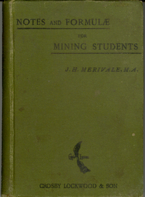
Book, Notes and formulae for mining students, 1897, 1897
... ...newcastle coal field...Bulman was an associate of the Institution of Civil Engineers and a member of the federated Institution of Mining Engineers. mining brook mining students mathematics newcastle coal field ropes chains seams dykes dams timber measure timber costing mines act rules explosives act horses windmills horse power boilers explosions compressed air wire ropes steam water power electricity sinking winding draining hauling chemistry gases ventilation boring formulae Green hard covered book of 188 pages. ...J.H. Merivale was a prodfessor of mining in the Durham College of Science, Newcastle-Upon-Tyne. H.F. Bulman was an associate of the Institution of Civil Engineers and a member of the federated Institution of Mining Engineers. Green hard covered book of 188 pages. mining, brook, mining students, mathematics, newcastle coal field, ropes, chains, seams, dykes, dams, timber measure, timber costing, mines act, rules, explosives act, horses, windmills, horse power, boilers explosions, compressed air, wire ropes, steam, water power, electricity, sinking, winding, draining, hauling, chemistry, gases, ventilation, boring, formulae -
Federation University Historical Collection
Book, Power and Heat, c1928
... ...Yallourn Brown Coal Field...SEC Yallourn Brown Coal Field power stations power generation Yallourn Open Cut Richmond Power Station Latrobe River yarraville terminal station sugarloaf-rubicon royston river briquetting factory yallourn briquettes Charles Beanland Stamped "C.H. ...When this book was published when Sir John Monash was the Chair of the State Electricity Commission of Victoria. Small Charcoal soft covered book on the State Electricity Commission of Victoria, Stamped "C.H. Beanland"state electricity commission of victoria., sec, yallourn brown coal field, power stations, power generation, yallourn open cut, richmond power station, latrobe river, yarraville terminal station, sugarloaf-rubicon, royston river, briquetting factory yallourn, briquettes, charles beanland -
Coal Creek Community Park & Museum
Book - Green book, Two Pools in a Field, 1967 London
... Coal Creek Community Park & Museum 12 Silkstone Road Korumburra gippsland Hard back covered book, green in colour. The book is titled Two Pools in a Field and the author is Ursula Bloom. ...Hard back covered book, green in colour. The book is titled Two Pools in a Field and the author is Ursula Bloom. Reference to the Batman Book Club.