Showing 495 items matching "conservation areas"
-
 Port Melbourne Historical & Preservation Society
Booklet, Ministry of Planning & Environment, Urban Conservation Areas, Aug 1986
... Urban Conservation Areas......urban conservation areas...Booklet outlining the historic and architectural character of a number of areas in Melbourne's inner suburbs including Port Melbourne, and their subsequent designation as Urban Conservation areas. Brown and cream 14 page booklet, cover showing terrace houses. ...Also Community Planning Bulletin Urban Conservation Areas Booklet Ministry of Planning & Environment F D Atkinson, Government Printer ...Booklet outlining the historic and architectural character of a number of areas in Melbourne's inner suburbs including Port Melbourne, and their subsequent designation as Urban Conservation areas. Brown and cream 14 page booklet, cover showing terrace houses. Also Community Planning Bulletintown planning, built environment, parks and gardens, heritage, conservation - urban, conservation - parks and boulevards, ministry for planning and environment, urban conservation areas -
Glen Eira Historical Society
Document - Historic Conservation Areas Project
... Historic Conservation Areas Project...Historic Conservation Areas Project Niven Barbara...Note: newsletters stamped with Caulfield Historical Society. 2/Letter (one page on official city of Caulfield letterhead) from Andrew Rodda (manager planning) to Hazal Ford (dated 13/11/1989) describing ‘council resolved on 18/07/1989 to proceed with preliminary conservation survey’ and mentions that a copy is included. 3/Preliminary conservation survey for the City of Caulfield (nine pages) describing background, study area, budget, purpose, study outline, timeframe, report format, ownership, tasks and background information (mentions number and types of houses and properties as at 1986 and 1988) and a map of City of Caulfield. 4/Booklet (28 pages) titled ‘Heritage Area – Caulfield North Draft Heritage Guidelines July 1999 – City of Glen Eira’, containing Caulfield North Heritage Area, cultural heritage, Heritage Overlay Area, architectural description, common architectural forms and features, development guidelines, key design checklist. ...It includes a map of the Caulfield North Heritage Overlay Area, two illustrations about the development envelope and many black-and-white photographs of houses and architectural features. Historic Conservation Areas Project Niven Barbara Newsletters Town Planning Historic Buildings Heritage Studies Housing Royal Historical Society of Victoria (RHSV) Read Michael Plans Local Government Historical Societies Committee for Urban Action (CUA) National Trust Hopkins Sherry Ms. ...Contains 4 items relating to historic conservation: 1/Five newsletters (one page each newsletter, dated 07/1975, 08/1975, 09/1975, 10/1975 and the final one 12/1975) describing how the project evolved, project funds, progress, study method, project 1 report, project 2 report and summary as no further funds available. Project was to include all of Melbourne but funding did not allow this. Note: newsletters stamped with Caulfield Historical Society. 2/Letter (one page on official city of Caulfield letterhead) from Andrew Rodda (manager planning) to Hazal Ford (dated 13/11/1989) describing ‘council resolved on 18/07/1989 to proceed with preliminary conservation survey’ and mentions that a copy is included. 3/Preliminary conservation survey for the City of Caulfield (nine pages) describing background, study area, budget, purpose, study outline, timeframe, report format, ownership, tasks and background information (mentions number and types of houses and properties as at 1986 and 1988) and a map of City of Caulfield. 4/Booklet (28 pages) titled ‘Heritage Area – Caulfield North Draft Heritage Guidelines July 1999 – City of Glen Eira’, containing Caulfield North Heritage Area, cultural heritage, Heritage Overlay Area, architectural description, common architectural forms and features, development guidelines, key design checklist. It includes a map of the Caulfield North Heritage Overlay Area, two illustrations about the development envelope and many black-and-white photographs of houses and architectural features.historic conservation areas project niven barbara, newsletters, town planning, historic buildings, heritage studies, housing, royal historical society of victoria (rhsv), read michael, plans, local government, historical societies, committee for urban action (cua), national trust, hopkins sherry ms., ford hazel, preliminary conservation survey, town planning, heritage studies, rodda andrew, city of caulfield, housing estates, victoria national estate grants program, australia icomos, burra charter, buildings structures and establishments, land surveys, suburbs, historic buildings, architectural significance, ‘caulfield’s heritage study’, soloman geulah dr., caulfield library, dandenong road, nepean highway, hotham street, iknerman road, orrong road, north road, poath road, ‘plan of the city of caulfield’, north ward, east ward, south ward, west ward, kooyong road, neerim road, bambra road, balaclava road, shire of caulfield, railways, world war 1914-1918, depression 1929-1939, rippon lea, labassa, parks, mansions, community services, ‘caulfield north draft heritage guidelines july 1999’, city of glen eira, caulfield north heritage area, glen eira heritage management plan, mayfield grove, normanby avenue, carnarvon street, glenferrie street, arthur street, malakoff street, normanby road, heritage advisory service, construction materials, victorian style, mediterranean style, spanish mission style, californian bungalow style, federation style, architectural style, architectural features, heritage conservation design, building construction, building regulations, aboriginal peoples, carnarvon road -
Port Melbourne Historical & Preservation Society
Booklet - Ministry for Planning and Environment, Urban Conservation Areas, Aug 1986
... Urban Conservation Areas...Ministry for Planning and Environment booklet of Urban Conservation Areas August 1986, detailing in words and sketches areas of inner Melbourne of special significance historically and architecturally, to be preserved. 16 pp, brown ink on cream paper....Urban Conservation Areas Booklet Ministry for Planning and Environment Ministry for Planning and Environment Government Printer ...Ministry for Planning and Environment booklet of Urban Conservation Areas August 1986, detailing in words and sketches areas of inner Melbourne of special significance historically and architecturally, to be preserved. 16 pp, brown ink on cream paper.built environment, garden city, town planning, victorian ministry for planning and environment -
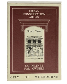 Robin Boyd Foundation
Pamphlet, City of Melbourne, Urban Conservation Areas South Yarra, 1987
... Urban Conservation Areas South Yarra...Guidelines to newly introduced Urban Conservation Area...Robin Boyd Foundation 290 Walsh Street South Yarra melbourne Guidelines to newly introduced Urban Conservation Area urban conservation environment Walsh St library Urban Conservation Areas South Yarra Pamphlet City of Melbourne ...Guidelines to newly introduced Urban Conservation Areaurban conservation, environment, walsh st library -
 Eltham District Historical Society Inc
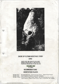
Document, Carlotta Kellaway, Shire of Eltham Heritage Study 1992 Volume 1: Recommendations Identified Places, 1992
... ...conservation areas...Shire of Eltham Heritage Study 1992 prepared by David Bick and Carlotta Kellaway; Garden Evaluation by John Patrick and Planting Evaluation by Ken Wallace Volume One: Recommendations, Conservation Areas, Identified Places Volume Two: Environmental History and Bibliography Volume Three: Culturally Significant Themes and the Evaluations of the Individually Identified Places that Illustrate the Themes...Background history carlotta kellaway conservation areas culturally significant themes david bick garden evaluation Heritage Study identified places john patrick ken wallace planting evaluation recommendations shire of eltham heritage study 167 A4 pages (double sided), spiral bound with clear pastic front cover and black card end cover. ...Shire of Eltham Heritage Study 1992 prepared by David Bick and Carlotta Kellaway; Garden Evaluation by John Patrick and Planting Evaluation by Ken Wallace Volume One: Recommendations, Conservation Areas, Identified Places Volume Two: Environmental History and Bibliography Volume Three: Culturally Significant Themes and the Evaluations of the Individually Identified Places that Illustrate the ThemesProvides the foundation for future planning assessments in the Shire of Eltham.167 A4 pages (double sided), spiral bound with clear pastic front cover and black card end cover.background history, carlotta kellaway, conservation areas, culturally significant themes, david bick, garden evaluation, heritage study, identified places, john patrick, ken wallace, planting evaluation, recommendations, shire of eltham heritage study -
 Eltham District Historical Society Inc
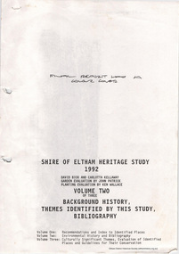
Document, Carlotta Kellaway, Shire of Eltham Heritage Study 1992 Volume 2 (draft): Background History - Themes identified by this study, Bibliography (pages 201-289), 1992
... ...conservation areas...Shire of Eltham Heritage Study 1992 prepared by David Bick and Carlotta Kellaway; Garden Evaluation by John Patrick and Planting Evaluation by Ken Wallace Volume One: Recommendations, Conservation Areas, Identified Places Volume Two: Environmental History and Bibliography Volume Three: Culturally Significant Themes and the Evaluations of the Individually Identified Places that Illustrate the Themes...Background history carlotta kellaway conservation areas culturally significant themes david bick garden evaluation Heritage Study identified places john patrick ken wallace planting evaluation recommendations shire of eltham heritage study 90 A4 pages (double sided), contyained in black PVC 2-ring binder. ...Shire of Eltham Heritage Study 1992 prepared by David Bick and Carlotta Kellaway; Garden Evaluation by John Patrick and Planting Evaluation by Ken Wallace Volume One: Recommendations, Conservation Areas, Identified Places Volume Two: Environmental History and Bibliography Volume Three: Culturally Significant Themes and the Evaluations of the Individually Identified Places that Illustrate the ThemesProvides the foundation for future planning assessments in the Shire of Eltham.90 A4 pages (double sided), contyained in black PVC 2-ring binder.background history, carlotta kellaway, conservation areas, culturally significant themes, david bick, garden evaluation, heritage study, identified places, john patrick, ken wallace, planting evaluation, recommendations, shire of eltham heritage study -
 Eltham District Historical Society Inc
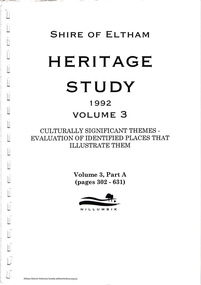
Document, Carlotta Kellaway, Shire of Eltham Heritage Study 1992 Volume 3: Culturally Significant Themes - Evaluation of identified places that illustrate them; Volume 3, Part A (pages 302-631), 1992
... david bick, carlotta kellaway, john patrick, ken wallace, shire of eltham heritage study, garden evaluation, planting evaluation, recommendations, conservation areas, identified places, environmental history, culturally significant themes...Shire of Eltham Heritage Study 1992 prepared by David Bick and Carlotta Kellaway; Garden Evaluation by John Patrick and Planting Evaluation by Ken Wallace Volume One: Recommendations, Conservation Areas, Identified Places Volume Two: Environmental History and Bibliography Volume Three: Culturally Significant Themes and the Evaluations of the Individually Identified Places that Illustrate the Themes...Eltham District Historical Society Inc 728 Main Rd Eltham melbourne Shire of Eltham Heritage Study 1992 prepared by David Bick and Carlotta Kellaway; Garden Evaluation by John Patrick and Planting Evaluation by Ken Wallace Volume One: Recommendations, Conservation Areas, Identified Places Volume Two: Environmental History and Bibliography Volume Three: Culturally Significant Themes and the Evaluations of the Individually Identified Places that Illustrate the Themes Provide the foundation for future planning assessments in the shire david bick, carlotta kellaway, john patrick, ken wallace, shire of eltham heritage study, garden evaluation, planting evaluation, recommendations, conservation areas, identified places, environmental history, culturally significant themes 167 A4 pages (double sided), spiral bound with clear pastic front cover and black card end cover. ...Shire of Eltham Heritage Study 1992 prepared by David Bick and Carlotta Kellaway; Garden Evaluation by John Patrick and Planting Evaluation by Ken Wallace Volume One: Recommendations, Conservation Areas, Identified Places Volume Two: Environmental History and Bibliography Volume Three: Culturally Significant Themes and the Evaluations of the Individually Identified Places that Illustrate the ThemesProvide the foundation for future planning assessments in the shire167 A4 pages (double sided), spiral bound with clear pastic front cover and black card end cover.david bick, carlotta kellaway, john patrick, ken wallace, shire of eltham heritage study, garden evaluation, planting evaluation, recommendations, conservation areas, identified places, environmental history, culturally significant themes -
 Eltham District Historical Society Inc
Document, Carlotta Kellaway, Shire of Eltham Heritage Study 1992 Volume 3: Culturally Significant Themes - Evaluation of identified places that illustrate them; Volume 3, Part B (pages 632-887), 1992
... david bick, carlotta kellaway, john patrick, ken wallace, shire of eltham heritage study, garden evaluation, planting evaluation, recommendations, conservation areas, identified places, environmental history, culturally significant themes...Shire of Eltham Heritage Study 1992 prepared by David Bick and Carlotta Kellaway; Garden Evaluation by John Patrick and Planting Evaluation by Ken Wallace Volume One: Recommendations, Conservation Areas, Identified Places Volume Two: Environmental History and Bibliography Volume Three: Culturally Significant Themes and the Evaluations of the Individually Identified Places that Illustrate the Themes...Eltham District Historical Society Inc 728 Main Rd Eltham melbourne Shire of Eltham Heritage Study 1992 prepared by David Bick and Carlotta Kellaway; Garden Evaluation by John Patrick and Planting Evaluation by Ken Wallace Volume One: Recommendations, Conservation Areas, Identified Places Volume Two: Environmental History and Bibliography Volume Three: Culturally Significant Themes and the Evaluations of the Individually Identified Places that Illustrate the Themes Provide the foundation for future planning assessments in the shire david bick, carlotta kellaway, john patrick, ken wallace, shire of eltham heritage study, garden evaluation, planting evaluation, recommendations, conservation areas, identified places, environmental history, culturally significant themes 130 A4 pages (double sided), spiral bound with clear pastic front cover and black card end cover. ...Shire of Eltham Heritage Study 1992 prepared by David Bick and Carlotta Kellaway; Garden Evaluation by John Patrick and Planting Evaluation by Ken Wallace Volume One: Recommendations, Conservation Areas, Identified Places Volume Two: Environmental History and Bibliography Volume Three: Culturally Significant Themes and the Evaluations of the Individually Identified Places that Illustrate the ThemesProvide the foundation for future planning assessments in the shire130 A4 pages (double sided), spiral bound with clear pastic front cover and black card end cover.david bick, carlotta kellaway, john patrick, ken wallace, shire of eltham heritage study, garden evaluation, planting evaluation, recommendations, conservation areas, identified places, environmental history, culturally significant themes -
 Eltham District Historical Society Inc
Document, Carlotta Kellaway, Shire of Eltham Heritage Study 1992 Volume 3: Culturally Significant Themes - Evaluation of identified places that illustrate them; Volume 3, Part C (pages 888-1115), 1992
... david bick, carlotta kellaway, john patrick, ken wallace, shire of eltham heritage study, garden evaluation, planting evaluation, recommendations, conservation areas, identified places, environmental history, culturally significant themes...Shire of Eltham Heritage Study 1992 prepared by David Bick and Carlotta Kellaway; Garden Evaluation by John Patrick and Planting Evaluation by Ken Wallace Volume One: Recommendations, Conservation Areas, Identified Places Volume Two: Environmental History and Bibliography Volume Three: Culturally Significant Themes and the Evaluations of the Individually Identified Places that Illustrate the Themes...Eltham District Historical Society Inc 728 Main Rd Eltham melbourne Shire of Eltham Heritage Study 1992 prepared by David Bick and Carlotta Kellaway; Garden Evaluation by John Patrick and Planting Evaluation by Ken Wallace Volume One: Recommendations, Conservation Areas, Identified Places Volume Two: Environmental History and Bibliography Volume Three: Culturally Significant Themes and the Evaluations of the Individually Identified Places that Illustrate the Themes Provide the foundation for future planning assessments in the shire david bick, carlotta kellaway, john patrick, ken wallace, shire of eltham heritage study, garden evaluation, planting evaluation, recommendations, conservation areas, identified places, environmental history, culturally significant themes 115 A4 pages (double sided), spiral bound with clear pastic front cover and black card end cover. ...Shire of Eltham Heritage Study 1992 prepared by David Bick and Carlotta Kellaway; Garden Evaluation by John Patrick and Planting Evaluation by Ken Wallace Volume One: Recommendations, Conservation Areas, Identified Places Volume Two: Environmental History and Bibliography Volume Three: Culturally Significant Themes and the Evaluations of the Individually Identified Places that Illustrate the ThemesProvide the foundation for future planning assessments in the shire115 A4 pages (double sided), spiral bound with clear pastic front cover and black card end cover.david bick, carlotta kellaway, john patrick, ken wallace, shire of eltham heritage study, garden evaluation, planting evaluation, recommendations, conservation areas, identified places, environmental history, culturally significant themes -
 Eltham District Historical Society Inc
Document, Carlotta Kellaway, Shire of Eltham Heritage Study 1992 Volume 3: Culturally Significant Themes - Evaluation of identified places that illustrate them; Volume 3, Part D (pages 1116-1367), 1992
... david bick, carlotta kellaway, john patrick, ken wallace, shire of eltham heritage study, garden evaluation, planting evaluation, recommendations, conservation areas, identified places, environmental history, culturally significant themes...Shire of Eltham Heritage Study 1992 prepared by David Bick and Carlotta Kellaway; Garden Evaluation by John Patrick and Planting Evaluation by Ken Wallace Volume One: Recommendations, Conservation Areas, Identified Places Volume Two: Environmental History and Bibliography Volume Three: Culturally Significant Themes and the Evaluations of the Individually Identified Places that Illustrate the Themes...Eltham District Historical Society Inc 728 Main Rd Eltham melbourne Shire of Eltham Heritage Study 1992 prepared by David Bick and Carlotta Kellaway; Garden Evaluation by John Patrick and Planting Evaluation by Ken Wallace Volume One: Recommendations, Conservation Areas, Identified Places Volume Two: Environmental History and Bibliography Volume Three: Culturally Significant Themes and the Evaluations of the Individually Identified Places that Illustrate the Themes Provide the foundation for future planning assessments in the shire david bick, carlotta kellaway, john patrick, ken wallace, shire of eltham heritage study, garden evaluation, planting evaluation, recommendations, conservation areas, identified places, environmental history, culturally significant themes 127 A4 pages (double sided) and 3 A3 fold-out pages, spiral bound with clear pastic front cover and black card end cover. ...Shire of Eltham Heritage Study 1992 prepared by David Bick and Carlotta Kellaway; Garden Evaluation by John Patrick and Planting Evaluation by Ken Wallace Volume One: Recommendations, Conservation Areas, Identified Places Volume Two: Environmental History and Bibliography Volume Three: Culturally Significant Themes and the Evaluations of the Individually Identified Places that Illustrate the ThemesProvide the foundation for future planning assessments in the shire127 A4 pages (double sided) and 3 A3 fold-out pages, spiral bound with clear pastic front cover and black card end cover.david bick, carlotta kellaway, john patrick, ken wallace, shire of eltham heritage study, garden evaluation, planting evaluation, recommendations, conservation areas, identified places, environmental history, culturally significant themes -
 Eltham District Historical Society Inc
Document, Carlotta Kellaway, Shire of Eltham Heritage Study 1992 Volume 3: Culturally Significant Themes - Evaluation of identified places that illustrate them; Volume 3, Part E (pages 1368-1597), 1992
... david bick, carlotta kellaway, john patrick, ken wallace, shire of eltham heritage study, garden evaluation, planting evaluation, recommendations, conservation areas, identified places, environmental history, culturally significant themes...Shire of Eltham Heritage Study 1992 prepared by David Bick and Carlotta Kellaway; Garden Evaluation by John Patrick and Planting Evaluation by Ken Wallace Volume One: Recommendations, Conservation Areas, Identified Places Volume Two: Environmental History and Bibliography Volume Three: Culturally Significant Themes and the Evaluations of the Individually Identified Places that Illustrate the Themes...Eltham District Historical Society Inc 728 Main Rd Eltham melbourne Shire of Eltham Heritage Study 1992 prepared by David Bick and Carlotta Kellaway; Garden Evaluation by John Patrick and Planting Evaluation by Ken Wallace Volume One: Recommendations, Conservation Areas, Identified Places Volume Two: Environmental History and Bibliography Volume Three: Culturally Significant Themes and the Evaluations of the Individually Identified Places that Illustrate the Themes Provide the foundation for future planning assessments in the shire david bick, carlotta kellaway, john patrick, ken wallace, shire of eltham heritage study, garden evaluation, planting evaluation, recommendations, conservation areas, identified places, environmental history, culturally significant themes 117 A4 pages (double sided) and on A3 (double-dided) fold-out page, spiral bound with clear pastic front cover and black card end cover. ...Shire of Eltham Heritage Study 1992 prepared by David Bick and Carlotta Kellaway; Garden Evaluation by John Patrick and Planting Evaluation by Ken Wallace Volume One: Recommendations, Conservation Areas, Identified Places Volume Two: Environmental History and Bibliography Volume Three: Culturally Significant Themes and the Evaluations of the Individually Identified Places that Illustrate the ThemesProvide the foundation for future planning assessments in the shire117 A4 pages (double sided) and on A3 (double-dided) fold-out page, spiral bound with clear pastic front cover and black card end cover.david bick, carlotta kellaway, john patrick, ken wallace, shire of eltham heritage study, garden evaluation, planting evaluation, recommendations, conservation areas, identified places, environmental history, culturally significant themes -
 Greensborough Historical Society
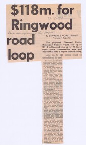
Memorabilia - Newspaper Clipping, The Herald, $118m. for Ringwood road loop, 18/07/1978
... The proposed Diamond Creek to Ringwood freeway would cost up to $118 million and take up to 171 ha. of open space, conservation area and residential land a report showed today. ...Greensborough Historical Society 34A Glenauburn Road Lower Plenty Lower Plenty melbourne The proposed Diamond Creek to Ringwood freeway would cost up to $118 million and take up to 171 ha. of open space, conservation area and residential land a report showed today. ...The proposed Diamond Creek to Ringwood freeway would cost up to $118 million and take up to 171 ha. of open space, conservation area and residential land a report showed today. Bruce Morgan was the first Shire Secretary (1964-1983) of the Shire of Diamond Valley. This collection was compiled by his wife, Mavis Morgan, detailing the events they attended in their official capacityNews clipping in black textHandwritten on clipping: "Bruce Morgan was organising this proposal"bruce morgan, mavis morgan, shire of diamond valley, outer ring freeway -
 Mont De Lancey
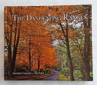
Book, Kornelia Freeman et al, The Dandenong Ranges, 2011
... The Dandenong ranges have a rich history spanning over 35,000 years of indigenous occupation, significant 19th-century timber clearing for Melbourne, and development into a popular 20th-century tourism, residential, and conservation area. The ranges were heavily logged in the 1850s, leading to the establishment of the Dandenong Ranges National Park in 1987. ...The Dandenong ranges have a rich history spanning over 35,000 years of indigenous occupation, significant 19th-century timber clearing for Melbourne, and development into a popular 20th-century tourism, residential, and conservation area. The ranges were heavily logged in the 1850s, leading to the establishment of the Dandenong Ranges National Park in 1987. ...Tourists come from all over the world to enjoy the prized gardens of Victoria's Dandenong Ranges. This beautifully produced book showcases the splendour of the public and private gardens of the Dandenongs as well as its unique villages and native animals and birds.A colourful covered book showing a road winding through the beautiful autumn trees in the Dandenong Ranges approximately 40km from Melbourne. The title The Dandenong Ranges is printed in white lettering at the top with the two authors listed below. The spine has the title, authors and M symbol for Melbourne Publishers. The title page has the same information with Portraits of Victoria added at the bottom right. There is a Contents, Introduction and then in alphabetical order, stunning photographs and detailed information about each place included. Mont De Lancey Historical Homestead is featured on p.144. At the back is an Acknowlegments list. Pp. 151.non-fictionTourists come from all over the world to enjoy the prized gardens of Victoria's Dandenong Ranges. This beautifully produced book showcases the splendour of the public and private gardens of the Dandenongs as well as its unique villages and native animals and birds.dandenong ranges - victoria, dandenong ranges - history, tourism victoria -
 Bendigo Historical Society Inc.
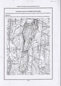
Document - DIAMOND HILL, GOLDEN GULLY COSERVATION AREA
... Map of Golden Gully conservation area comprising Glasgow and Golconda Consolidated, Glasgow Reef Company (Golden Gully) and New Napoleon. ...History House 11 Mackenzie Street Bendigo goldfields BENDIGO Mining golden gully Map of Golden Gully conservation area comprising Glasgow and Golconda Consolidated, Glasgow Reef Company (Golden Gully) and New Napoleon. ...Map of Golden Gully conservation area comprising Glasgow and Golconda Consolidated, Glasgow Reef Company (Golden Gully) and New Napoleon. The area is significant because it contains the 'best evidence for hydraulic sluicing on the field as well as several early reef mining sites' On top of page 'Eaglehawk & Bendigo Heritage Study, Significant areas' Mines marked on page: Goldfields Extended shaft South Concord shaft Concord shaft Morning Light shaft Hansel and Mundy shaftbendigo, mining, golden gully -
 City of Whittlesea
Photograph (item) - Photographs - Buildings, Epping Shire Hall
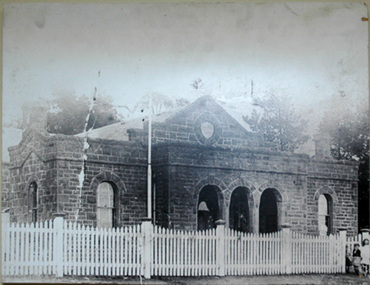
... Part of Epping Civic Precinct Heritage Conservation Area - 'the building reverted to its original role in 1939 when Epping again became the seat of the Whittlesea Council'...Part of Epping Civic Precinct Heritage Conservation Area - 'the building reverted to its original role in 1939 when Epping again became the seat of the Whittlesea Council' Epping Shire Council Whittlesea Council Epping Police Station digital image Epping Shire Hall Photograph Photographs - Buildings ...Image - Epping Shire Hall, c 1905 (F Coote) The Shire Hall was erected by Thomas Mitchell in 1871, at a cost of 628 Pounds. It served as council chambers and offices, courthouse, public meeting room and dance hall. (Wuchatsch & Hawke, 1988/1985). Part of Epping Civic Precinct Heritage Conservation Area - 'the building reverted to its original role in 1939 when Epping again became the seat of the Whittlesea Council'epping shire council, whittlesea council, epping police station -
 Bendigo Historical Society Inc.
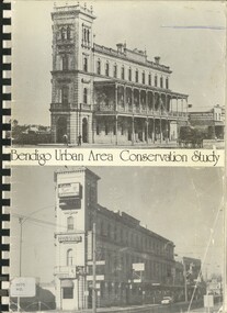
Book - BENDIGO URBAN AREA CONSERVATION STUDY, 1977
... BENDIGO URBAN AREA CONSERVATION STUDY...Bendigo Area Conservation Study - 192 pages with photos, illustrations and maps. ...Book BENDIGO URBAN AREA CONSERVATION STUDY ...Bendigo Area Conservation Study - 192 pages with photos, illustrations and maps. Written on front page ' 133 Mackenzie Street, Bendigo. Indecipherable signature with 'Bendigo, presented to RHSV Bendigo 1978'. 255pp.Lawrie Wilson & Associatesbendigo, buildings, conservation study, conservation, planning schemes, architecture, heritage houses -
Canterbury History Group
Document - Significant 19th century properties in Camberwell, Sanders and Butler, 1986
... A chronological list of significant nineteenth century properties in Camberwell, from the Camberwell Conservation Study - Study Area 1, 1986...Canterbury History Group 190A Canterbury Road Canterbury melbourne A chronological list of significant nineteenth century properties in Camberwell, from the Camberwell Conservation Study - Study Area 1, 1986 Canterbury Camberwell Balwyn Surrey Hills Camberwell Conservation Study Heritage Studies Butler> Graeme Historic Buildings City of Camberwell Shrublands Cullymont Eyre Court Frognall 1 page A4 typed document Document Significant 19th century properties in Camberwell Sanders and Butler ...A chronological list of significant nineteenth century properties in Camberwell, from the Camberwell Conservation Study - Study Area 1, 19861 page A4 typed documentcanterbury, camberwell, balwyn, surrey hills, camberwell conservation study, heritage studies, butler> graeme, historic buildings, city of camberwell, shrublands, cullymont, eyre court, frognall -
 Sunshine and District Historical Society Incorporated
Document - Maribyrnong Heritage Reviews, Jill Barnard, Graeme Butler, Francine Gilfedder & Gary Vines, 2000 & 2001
... 5822.01 - Maribyrnong Heritage Review Volume 1.pdf Historic Places - Project Methods and Results 5822.02 - Maribyrnong Heritage Review Volume 2.pdf Environmental History City of Maribyrnong 5822.03 - Maribyrnong Heritage Review Volume 3.pdf Historic Places Industrial places in the City of Maribyrnong 5822.04 - Maribyrnong Heritage Review Volume 4.pdf Historic Places - Non-industrial places in former City of Sunshine (Maribyrnong, Maidstone, Braybrook and Tottenham) 5822.05 - Maribyrnong Heritage Review Volume 5.pdf Historic Places - Urban Conservation Areas & Individual Places in the former City of Footscray 5822.06 - Maribyrnong Heritage Review Volume 6.pdf Historic Places - Significant Trees in the City of Maribyrnong...Maidstone Braybrook Maribyrnong Tottenham 5822.01 - Maribyrnong Heritage Review Volume 1.pdf Historic Places - Project Methods and Results 5822.02 - Maribyrnong Heritage Review Volume 2.pdf Environmental History City of Maribyrnong 5822.03 - Maribyrnong Heritage Review Volume 3.pdf Historic Places Industrial places in the City of Maribyrnong 5822.04 - Maribyrnong Heritage Review Volume 4.pdf Historic Places - Non-industrial places in former City of Sunshine (Maribyrnong, Maidstone, Braybrook and Tottenham) 5822.05 - Maribyrnong Heritage Review Volume 5.pdf Historic Places - Urban Conservation Areas & Individual Places in the former City of Footscray 5822.06 - Maribyrnong Heritage Review Volume 6.pdf Historic Places - Significant Trees in the City of Maribyrnong Six digital PDF files Document Maribyrnong Heritage Reviews Jill Barnard, Graeme Butler, Francine Gilfedder & Gary Vines ...Braybrook, Maribyrnong, Tottenham and sections of Maidstone were in the Shire of Braybrook and subsequently the City of Sunshine prior to the 1994 council mergers. A number of sites from the above locations are listed in these documents and therefore are of interest to the Sunshine and District Historical Society.5822.01 - Maribyrnong Heritage Review Volume 1.pdf Historic Places - Project Methods and Results 5822.02 - Maribyrnong Heritage Review Volume 2.pdf Environmental History City of Maribyrnong 5822.03 - Maribyrnong Heritage Review Volume 3.pdf Historic Places Industrial places in the City of Maribyrnong 5822.04 - Maribyrnong Heritage Review Volume 4.pdf Historic Places - Non-industrial places in former City of Sunshine (Maribyrnong, Maidstone, Braybrook and Tottenham) 5822.05 - Maribyrnong Heritage Review Volume 5.pdf Historic Places - Urban Conservation Areas & Individual Places in the former City of Footscray 5822.06 - Maribyrnong Heritage Review Volume 6.pdf Historic Places - Significant Trees in the City of Maribyrnongmaidstone, braybrook, maribyrnong, tottenham -
 Orbost & District Historical Society
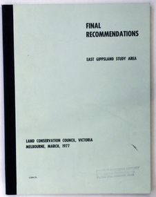
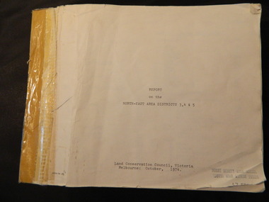
document, FINAL RECOMMENDATIONS E. GIPPSLAND STUDY AREA - LAND CONSERVATION COUNCIL, VICTORIA March 1977, March 1977
... GIPPSLAND STUDY AREA - LAND CONSERVATION COUNCIL, VICTORIA March 1977...A document of 75 pp with a pale green cover and black print, titled Final Recommendations East Gippsland Study area. Land Conservation Council, Melbourne, March, 1977....Land Conservation Council, Melbourne, March, 1977. FINAL RECOMMENDATIONS E. GIPPSLAND STUDY AREA - LAND CONSERVATION COUNCIL, VICTORIA March 1977 document Land Conservation Council ...Established in 1971, the Land Conservation Council operated under the Land Conservation Council Act 1970. In July 1997, the Environment Conservation Council Act 1997 came into operation. This Act revoked the Land Conservation Council Act 1970 and abolished the Land Conservation Council. An Environment Conservation Council was established in its place. (ref. TROVE) This document is a useful reference tool.A document of 75 pp with a pale green cover and black print, titled Final Recommendations East Gippsland Study area. Land Conservation Council, Melbourne, March, 1977.land-conservation-east-gippsland -
 Otway Districts Historical Society
Book, Land Conservation Council, Report on the Corangamite Study Area, May 1976
... Report on the Corangamite study area. Land Conservation Council. Melbourne; Land Conservation Council; May 1976. x, 310 p.; illus, maps (separate). ... Council; Corangamite; geology; physiography; climate; water resources; soils; vegetation; fauna; Report on the Corangamite study area. Land Conservation Council. Melbourne; Land Conservation Council; May 1976. x, 310 p.; illus, maps (separate). ...The Report describes and assesses the natural resources of public land in the Corangamite study area, and provides a factual basis on which members of the community may base their submissions to the Council.Report on the Corangamite study area. Land Conservation Council. Melbourne; Land Conservation Council; May 1976. x, 310 p.; illus, maps (separate). Soft cover.land conservation council; corangamite; geology; physiography; climate; water resources; soils; vegetation; fauna; -
 Greensborough Historical Society
Article, Acknowledging the dedication and contribution of the late Infant Welfare Sister Alma Brown, 1916o
... Chronology of Alama Brown's life, work in maternal and child health in the Diamond Valley area and conservation, memorialised by Brown's Reserve in Greenhills. ...Greensborough Historical Society 34A Glenauburn Road Lower Plenty Lower Plenty melbourne Chronology of Alama Brown's life, work in maternal and child health in the Diamond Valley area and conservation, memorialised by Brown's Reserve in Greenhills. ...Chronology of Alama Brown's life, work in maternal and child health in the Diamond Valley area and conservation, memorialised by Brown's Reserve in Greenhills. Also a celebration of 100 years of Maternal and Child Health.4p. col. documents, photographsalma brown, infant welfare -
 Federation University Historical Collection
Photograph (black & White), Right Honorable Cecil John Rhodes - South Africa
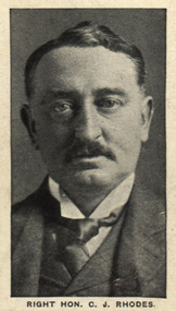
... The rest was spared development and is now an important conservation area. His will also provided for the establishment of the Rhodes Scholarship. ...The rest was spared development and is now an important conservation area. His will also provided for the establishment of the Rhodes Scholarship. cecil rhodes mining magnate south africa politician south africa prime minister Cape Colony british south africa company rhodesia jameson raid paul kruger south africa republic transvaal second boer war kimberley robert kekewich leander starr jameson muizenberg table mountain university of cape town kirstenbosch national garden Individual image from photographed poster of tobacco and cigarette cards. ...Cecil Rhodes was a British businessman, mining magnate and politician in South Africa. He was Prime Minister of the Cape Colony from 1890 to 1896. He believed in British Imperialism and he and his British South Africa Company formed the territory of Rhodesia in the early 1890s. He was forced to resign as Prime Minister in 1896 after the disastrous Jameson Raid, an unauthorised attack on Paul Kruger's South African Republic (Transvaal), which sent his brother to prison convicted of high treason and nearly sentenced to death. This event contributed to the outbreak of the Second Boer War. Rhodes went to Kimberley in a political move. During the war the military felt he was more of a liability than an asset and found him intolerable. The officer commanding the garrison of Kimberley, Lieutenant Colonel Robert Kekewich, experienced serious personal difficulties with Rhodes because of the latter's inability to co-operate. However, he still remained a leading figure in the politics of southern Africa. Rhodes was dogged by ill health his whole life. He died in 1902, aged 48, at his seaside cottage in Muizenberg. He was cared for by Leander Starr Jameson during his illness, becoming a trustee of his estate and residuary beneficiary of his will, which allowed him to continue living in Rhode's mansion after his death. His final will left a large area of land on the slopes of Table Mountain. Part of the estate became the upper campus of the University of Cape Town, another part became the Kirstenbosch National Botanical Garden. The rest was spared development and is now an important conservation area. His will also provided for the establishment of the Rhodes Scholarship. Individual image from photographed poster of tobacco and cigarette cards.cecil rhodes, mining magnate south africa, politician south africa, prime minister cape colony, british south africa company, rhodesia, jameson raid, paul kruger, south africa republic, transvaal, second boer war, kimberley, robert kekewich, leander starr jameson, muizenberg, table mountain, university of cape town, kirstenbosch national garden -
 Eltham District Historical Society Inc
Document - Property Binder, 616 Main Road, Eltham; Plum Cottage
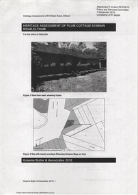
... This house was identified in the Shire of Shire of Eltham Heritage 1992 as contributory to the Eltham Gateway Conservation Area, then proposed as an urban conservation area (now Heritage Overlay Area). ...This house was identified in the Shire of Shire of Eltham Heritage 1992 as contributory to the Eltham Gateway Conservation Area, then proposed as an urban conservation area (now Heritage Overlay Area). ...Plum Cottage is covered by Heritage Overelay HO256 in the Nillumbuk Planning Scheme This two-lot land holding was created as a subdivision and sold to Charles Stuart McNeil by May 1955. Sometime in the period 1955-1960, the builder-designer, John Harcourt had created a pise house on the site, straddling the two subdivision lots. The designer, John M. Harcourt was a pioneer builder in pise-de-terre and mudbrick in the Eltham Shire, Eltham being synonymous with alternative lifestyles and building practises until the onset of suburbia in the late 20th and early 21st centuries. This hipped-roof house is set high above Main Road on a V-shape plan characteristic of the Arts & Crafts style, with rammed earth or pise walls, timber joinery and a cement tiled roof. The V shape plan was used by important English and Eltham Arts & Crafts designers. The use of natural materials such as stone and timber construction is an essential part of the Arts & Crafts style and Harcourt’s work. So too is the application of the style on both the exterior and interior of the house as a holistic concept. The house adjoins the Lim Joon adobe house built and designed by Alistair Knox in the same era (HO119), thus forming a distinctive pair, both using an uncommon plan form. This house was identified in the Shire of Shire of Eltham Heritage 1992 as contributory to the Eltham Gateway Conservation Area, then proposed as an urban conservation area (now Heritage Overlay Area). Land Ownership Emily Jane Smith of 12 Woodside Street Fitzroy owned Crown Allotments 1 & 2 Sections 14, 27 by August 1918, selling to William Henry Smith of 12 Woodside Street, Nth Fitzroy May 1921. (John) James Isherwood of Main Road, Eltham owned the property by 1928 (the year of his death) with the beneficiary of his estate and next owner of this site being his widow, Minnie Maria Isherwood of Cemetery Road, Eltham. His holding in Main Road included parts of what was described in rate records as allotments1 & 2 Section E6. In the late 1930s, early 1940s her son Alfred John Isherwood was also rated for the land around this site, with the rated nett annual value varying between £2 and £5. Alfred Isherwood also lived at Main Road, Eltham with his wife Ellen: her early death at the age of 24 was reported in the Argus of 1923. Part of the Isherwood land was divided off and sold to Charles Stuart McNeil by May1955. Sometime in the period 1955-1960, the builder-designer, John Harcourt had created a pise house on the site, straddling the two subdivision lots. The house is visible on an aerial photograph from 1960s. Reputedly the house was called Plum Cottage and erected for Harcourt’s mother-in-law. A garage was added in 1959. Charles McNeil died in1971 aged 87: he was the son of Don McNeil and Margaret Arkell. Available rate records from the construction era start in the of the 1970s (1972-3) and list Mr H.C. & M/S A.V. Charity at 616 Main Road Eltham of this property with a nett annual value of $740. More recent valuer's data describes the property as lots 1 & 2 LP25668, located in the Central Riding of Eltham Shire, owned by Ann Valerie Charity and later, in 1990, by the Chincarini family. Building Description This hipped roof 11 .5 square house is set high above Main Road on a characteristic-shape plan and has rammed earth or pise walls, timber joinery and a cement tiled roof. The V-shape plan was used by Important designers such as C.F.A. Voysey (UK) who interpreted medieval domestic architecture as part of the Arts & Crafts style of the late 19th and early 20th centuries. The pise walls are covered with a textured render while the cement roofing tiles are also seen in the Harcourt Hill examples. Reputedly the ceiling joists are of a deep section and span long lengths with no need for hanging beams in the roof space. The ceilings are low and panelled in main rooms with apparently Caneite soft board infill panels between the exposed ceiling beams. These are painted white but may have been stained at one time. The focus of the house is the large living area with its vast random stone fireplace. Significance Plum Cottage is significant to the locality of Eltham because: Historically: • Plum Cottage is closely associated with the important historical theme of earth construction evident in Eltham and elsewhere in the Shire since theear1y Arts & Crafts inspired creations at Penleigh Boyd's The Robins (1912, HO101) and those at Montsalvat (1934-, HO82) but more prominent from the Second War period when earth building in Eltham was promoted in national periodicals as an alternative building method that avoided the building materials shortages of that era; • The choice of the earth building technique also expresses the theme of refuge or alternative living, synonymous with Eltham in the early to mid 20th century; • as a good example of domestic architecture from John Harcourt who was the first major post Second War figure in an important phase of Eltham’s earth building development, using his characteristic Old English or Arts& Crafts style that relies in this case on the pise wall construction, pitched roof forms, exposed ceiling joists, half timbering, random stonework, and panelled internal wall finishes. Architecturally: • Plum Cottage's pise wall construction is uncommon among the early earth-walled structures in the Shire, that are mainly of adobe or mud brick, and as a building material is uncommon among the Shire’s suburban dwellings generally which are clad typically with either fired clay bricks or timber boarding. Aesthetically: • Plum Cottage is a good and well preserved example of a modern Old English or Arts & Crafts style earth-walled building in the Shire • For the proximity of the significant Lim Joon adobe house designed by Alistair Knox adjoining to the north, providing a distinctive earth wall house pair, with uncommon plan forms. Reference Heritage Assessment of Plum Cottage, 616 Main Road, Eltham; Graeme Butler & Associates 2010main road, eltham, property, houses, (john) james isherwood, alfred john isherwood, ann valerie charity, arts and crafts style, charles stuart mcneil, chincarini family, eltham gateway zone, emily jane smith, h.c. charity, heritage assessment, john harcourt, john m. harcourt, lim joon house, main road eltham, minnie maria isherwood, pise construction, plum cottage -
 Warrnambool and District Historical Society Inc.
Book, If These Walls Could Talk, 1995
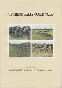
... area and the various different styles with photographs to illustrate the different features. It also has a number of first- hand accounts written by stonewallers. This study has social, historical, artistic and interpretive significance as the walls are an important feature of the district. The account written by former builders of the walls provides an interesting insight into the various styles and reasons for their construction. dry stone walls corangamite stone walls warrnambool and district history constructing dry stone walls Report of the Corangamite dry stone walls Conservation project. ...This publication is a result of funding made to the Corangamite Arts Council in 1990-91. Its aims were to identify and research the dry stone walls of the region, to raise their profile and through workshops continue the skills of those wanting to learn more about the craft. The book gives the history of the practice in the area and the various different styles with photographs to illustrate the different features. It also has a number of first- hand accounts written by stonewallers.This study has social, historical, artistic and interpretive significance as the walls are an important feature of the district. The account written by former builders of the walls provides an interesting insight into the various styles and reasons for their construction.Light green card cover. Front cover has 4 photographs of dry stone walls with title and other text in black. Back cover is plain. 144 pages. It contains a large number of black and white photographs of stone walls from around the district as well as maps. Report of the Corangamite dry stone walls Conservation project.dry stone walls, corangamite stone walls, warrnambool and district history, constructing dry stone walls -
 Kiewa Valley Historical Society
Report - Alpine Study Area Volume 2 Maps, Land Conservation Council, 1970s
... area...land conservation council...Blue box shaped folder containing 9 of 10 Maps of the Alpine Study Area produced by the Land Conservation Council. Maps include 1. ...Others may provide information for future development such as mineral exploration, building of a dam / tunnel etc. alpine area maps of alpine area land conservation council Ex library item. Stamped in red "Discarded From Stock / Swan Hill Regional Library Blue box shaped folder containing 9 of 10 Maps of the Alpine Study Area produced by the Land Conservation Council. ...The Victorian Environmental Assessment Council and the former Environment Conservation Council (ECC) and Land Conservation Council (LCC) have completed 36 land use investigations over more than 35 years, including 27 regional reviews. They provide a framework for use of Public Land in Victoria. The Land Conservation Council was established by the Land Conservation Act 1970.These maps provide an assessment of the Alpine area at the time the maps were created. Some of the topics eg. Rainfall and water resources may change over the years thus providing a comparative analysis. Others may provide information for future development such as mineral exploration, building of a dam / tunnel etc.Blue box shaped folder containing 9 of 10 Maps of the Alpine Study Area produced by the Land Conservation Council. Maps include 1. Public land and descriptive blocks. 2. Physiography. 3. Topography. 4. Geology (missing). 5. Rainfall and water resources. 6. Vegetation 7. Land systems. 8. Recreation. 9. Primary production. 10. Minerals Ex library item. Stamped in red "Discarded From Stock / Swan Hill Regional Libraryalpine area, maps of alpine area, land conservation council -
 Kiewa Valley Historical Society
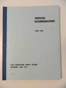
Report - Alpine Area Proposed Recommendations, Land Conservation Council, Victoria Melbourne, April 1978, April 1978
... area...land conservation council...It makes recommendations to the Minister for Conservation with respect to the use of public land. Notices showing the boundary of the study area ... published in the Victorian Government Gazette Sept. 1973. ...Of interest for research on the changing ideas regarding the use of public land and the environment. alpine area land conservation council alpine study area report Blue book bound by dark blue cloth tape. ...The Land Conservation Council was established by the Land Conservation Act 1970. It makes recommendations to the Minister for Conservation with respect to the use of public land. Notices showing the boundary of the study area ... published in the Victorian Government Gazette Sept. 1973. A descriptive report was published in July 1977. Submissions (1538) on the future use of public land were received & included those representing a wide cross-section of the community. These were considered in the final report.Of interest for research on the changing ideas regarding the use of public land and the environment.Blue book bound by dark blue cloth tape. It has 92 pages with maps at the end and an empty folder inside the back cover.alpine area, land conservation council, alpine study area report -
 Kiewa Valley Historical Society
Report - Land Conservation Council x2, Land Conservation Council, Victoria Melbourne, April 1978, October 1974
... Conservation Council to investigate and recommend to the Minister use of public land in Victoria. It describes and assesses the natural resources:-Physiography, Geology, Topography, Land Systems, Outdoor Recreation, Public land and blocks. Primary Production. Vegetation. North East Victoria includes the Kiewa Valley. This report gives an understanding of the development of the area ...Land Conservation Act 1970 established the Land Conservation Council to investigate and recommend to the Minister use of public land in Victoria. It describes and assesses the natural resources:-Physiography, Geology, Topography, Land Systems, Outdoor Recreation, Public land and blocks. Primary Production. Vegetation.North East Victoria includes the Kiewa Valley. This report gives an understanding of the development of the area.Thick heavy book with 312 pages with black and white photos. Back half has a folder with heavy cardboard attached to thick cardboard back cover. Inside folder are 9 maps with color each with a different title.Stamped on Front Cover: "Mount Beauty High School" Has a library borrowing slip at the back of the last page.land conservation council, environment, public land, kiewa valley, planning -
 Kiewa Valley Historical Society
Mills Collection of Papers, 1. Unknown 2. October 1964. 3. Unknown SECV. 4. June 1963. 5. Unknown, Victorian Dept of Education. 6. Unknown SECV
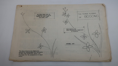
... Area' June 1963. 5. Victorian Department of Agriculture, 'Tobacco', Notes for Students/Geology/Maize Culture/The Buffalo Dam Project/Stamped with 'Hoys Passenger Service Pty Ltd'. 6, SEC Kiewa Region, Forestry and Conservation....conservation SECV No. 5. - Stamped with 'Hoys Passenger Service Pty Ltd' A collection of papers including: 1. Three poems. 2. The ''Three Floras of Bogong'Oct 1964. 3. 'SEC Bird Life within and adjacent to the Kiewa Works area ...Catelogue of flora and fauna of the 1960s in the Kiewa Region.A collection of papers including: 1. Three poems. 2. The ''Three Floras of Bogong'Oct 1964. 3. 'SEC Bird Life within and adjacent to the Kiewa Works area' recorded between 1963 and 1964. 4. 'General Geology of the Kiewa Area' June 1963. 5. Victorian Department of Agriculture, 'Tobacco', Notes for Students/Geology/Maize Culture/The Buffalo Dam Project/Stamped with 'Hoys Passenger Service Pty Ltd'. 6, SEC Kiewa Region, Forestry and Conservation.No. 5. - Stamped with 'Hoys Passenger Service Pty Ltd'flora, bogong, birds, geology, kiewa valley, tobacco, forestry and conservation, secv -
 Kiewa Valley Historical Society
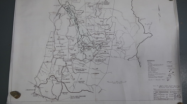
Map - Bogong High Plains - Grazing Runs, Grazing Run Boundaries 1960 - Soil Conservation Authority
... The Soil Conservation Authority recorded each family's area boundaries which were updated in June 1972 and continued to be adjusted until cattle were banned in 2005. ...The Soil Conservation Authority recorded each family's area boundaries which were updated in June 1972 and continued to be adjusted until cattle were banned in 2005. ...Cattle grazing on the Bogong High Plains during summer commenced in the 1840s and continued for many years. The Soil Conservation Authority recorded each family's area boundaries which were updated in June 1972 and continued to be adjusted until cattle were banned in 2005. The tradition of cattle grazing continues to be controversial.Holders of grazing rights for grazing on the Bogong High Plains were allocated specific areas recorded by the Soil Conservation Authority in 1972. Cattle have been banned in the Alpine National Park due to their impact on the environment.White paper with brown print. Bogong High Plains from Feathertop in the west to Mt Nelse in the east showing physical boundaries including the Kiewa Hydro Electric Scheme, roads, rivers and mountains. Names of families with grazing runs and the boundaries are shown.cattlemen, grazing runs, bogong high plains, kiewa valley families -
 Kiewa Valley Historical Society
Papers - Cattle Grazing, Bogong High Plains
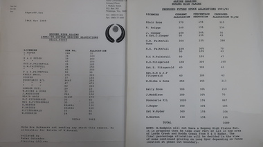
... areas due to concerns of their impact on the environment. Kiewa Valley cattle graziers were caught up in the controversy as it was their tradition dating back to the 1840s. This controversy continues as cattle grazing was banned in 2005. cattle grazing kiewa valley farmers ex S.C.A. / Benalla / Received 22nd Feb. 1979 / signed 4 pages with black print: 1. 1989/90 Cattle Grazing Allocation and Dept. of Conservation Forests and Lands, Wodonga. 2. ...Cattle grazing. In the 1990s government departments allocated the number of cattle being taken up to the Bogong High Plains by the families who traditionally leased land there.Cattle grazing had been banned in other Alpine areas due to concerns of their impact on the environment. Kiewa Valley cattle graziers were caught up in the controversy as it was their tradition dating back to the 1840s. This controversy continues as cattle grazing was banned in 2005. 4 pages with black print: 1. 1989/90 Cattle Grazing Allocation and Dept. of Conservation Forests and Lands, Wodonga. 2. Proposed Future Stock Allocations 1991/92 list of 16 families 3. & 4. List of families, ear marks, brands etc. dated 22nd Feb. 1979 stapled togetherex S.C.A. / Benalla / Received 22nd Feb. 1979 / signedcattle grazing, kiewa valley farmers