Showing 158 items matching "construction 1960s"
-
 Glenelg Shire Council Cultural Collection
Film - Film - Harbour Construction 1950s-1960s, n.d
... Film - Harbour Construction 1950s-1960s...Various films: **Euclids carrying stone and rubble to the beginnings of the Main Breakwater *Diving gear Diver (wearing helmet and canvas suit) ready to dive from near the slipway or Fishermen's Breakwater Diver with air tanks near Fishermen's Breakwater or trawler berth Dredging around near Fishermen's Breakwater - Henty Groyne Cape Grant temporary crusher (jumpy in places) Lewis Dredging/wash boring Levelling railway approach Fawthrop Lagoon Quarry Road - Quarry gates *denotes footage of interest Film Film - Harbour Construction 1950s-1960s ...Port of Portland AuthorityFront: Harbour Construction/ Portland (B & W) (blue pen and white sticky tape, top of reel)port of portland archives, film -
 Ballaarat Mechanics' Institute (BMI Ballarat)
Building The Civic Hall 1960s
... ...construction 1960s...Ballarat Civic Hall construction 1960s Building The Civic Hall 1960s ...This photograph is from the Max Harris Collection held by the Ballaraat Mechanics' Institute. Please contact BMI for all print and usage inquiries.ballarat, civic hall, construction 1960s -
 Kiewa Valley Historical Society
VHS Video - Kiewa, Kiewa Compile, Date compiled 25th Nov. 1998
... ...construction towns...1940s 1960s...The additional resources provided by the State Electricity Commission of Victoria of "alpine bush" fire control and management, together with an ongoing educational scheme for school children in learning about what constitutes the Alpine country's unique environment, are a very important offshoot, benefitting to both the communities within the Kiewa Valley and regional Victoria. kiewa hydro electricity state electricity commission of victoria construction towns 1940s 1960s mt beauty bogong falls creek clover power station mckay power station bill sutton news film construction workers early machinery Titled "Kiewa Compile" with 4 short films titled 1. ...The construction and development of the Kiewa Hydro scheme showing its construction and the people in work and play during its duration. It also shows the development of Mt Beauty and Bogong townships. The films were used as News Reels, Tourist Information and Entertainment.This item provids a snap shot in time (1990) when the Kiewa Valley was still relatively under populated and holiday houses owned by city bound workers was still relatively insignificant. As more and more holiday makers retire to a small but friendly region(Kiewa Valley and Mount Beauty) the increase in visitor numbers will affect the local rural bush scene more and more. The changes that will occur (in time) can be measured against the scenes presented in this video. The additional resources provided by the State Electricity Commission of Victoria of "alpine bush" fire control and management, together with an ongoing educational scheme for school children in learning about what constitutes the Alpine country's unique environment, are a very important offshoot, benefitting to both the communities within the Kiewa Valley and regional Victoria.This VHS tape is stored within its own plastic cover which has a front side Titled "KIEWA in the MAKING". The VHS tape is nestled within a formed inner structure which not only prevents the tape from moving to and fro but also unnecessary intrusion of foreign particles. Titled "Kiewa Compile" with 4 short films titled 1. Kiewa in the Making 2. Kiewa Capers 3. It only seems like yesterday 4. Kiewa.kiewa, hydro electricity, state electricity commission of victoria, construction towns, 1940s 1960s, mt beauty, bogong, falls creek, clover power station, mckay power station, bill sutton, news film, construction workers, early machinery -
 Ballaarat Mechanics' Institute (BMI Ballarat)
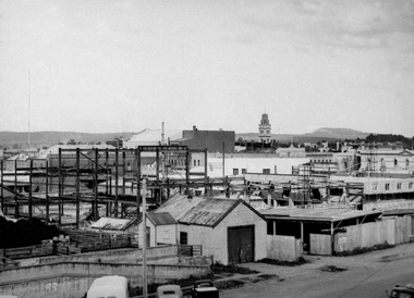
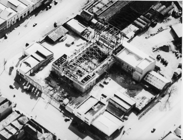
Aerial view buiding of Civic Hall 1960's
... construction...Civic Hall...1960s...Ballarat Aerial construction Civic Hall 1960s doveton armstrong mair Aerial view buiding of Civic Hall 1960's ...This photograph is from the Max Harris Collection held by the Ballaraat Mechanics' Institute. Please contact BMI for all print and usage inquiries.ballarat, aerial, construction, civic hall, 1960s, doveton, armstrong, mair -
 Ballaarat Mechanics' Institute (BMI Ballarat)
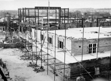
Construction of Ballarat Civic Hall
... Construction...Civic Hall...1960s...Ballarat Construction Civic Hall 1960s Construction of Ballarat Civic Hall ...This photograph is from the Max Harris Collection held by the Ballaraat Mechanics' Institute. Please contact BMI for all print and usage inquiries.ballarat, construction, civic hall, 1960s -
 Greensborough Historical Society
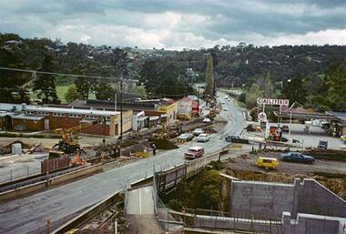
Photograph - Digital Image, Main Street upgrade 1960s, 1978c
... Photograph of upgrade works in lower Main Street area, taken in the late 1960s. Shows construction of rail bridge and Main Street....Greensborough Historical Society 34A Glenauburn Road Lower Plenty Lower Plenty melbourne Photograph of upgrade works in lower Main Street area, taken in the late 1960s. Shows construction of rail bridge and Main Street. main street greensborough Digital copy of colour photograph Main Street upgrade 1960s Photograph - Digital Image Sandy Anton ...Photograph of upgrade works in lower Main Street area, taken in the late 1960s. Shows construction of rail bridge and Main Street.Digital copy of colour photographmain street greensborough -
 Kiewa Valley Historical Society
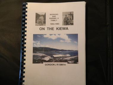
Book - On the Kiewa, Working & Raising a Family 1953 - 1963 by Gordon J. R. Smith, 9th September 2005
... Gordon gives an account of both working and living during the 1950s and early 1960s in a remote part of Victoria - the Kiewa Valley and in 2 small construction towns. ...Personal account of Gordon Smith's life when living in Mt Beauty and Bogong townships while working for the SECV on the Kiewa Hydro Electric Scheme.Gordon gives an account of both working and living during the 1950s and early 1960s in a remote part of Victoria - the Kiewa Valley and in 2 small construction towns. He gives a lot of detail eg. the weather, his work, the people, the activities, his family and leisure time.Plastic threaded spine holding 282 pages with black and white photos. Front Cover includes 2 small black and white photos either side of the title at the top and below the title a larger colored photo of Rocky Valley Dam. Author's name is underneath. "Dick Puttyfoot" on cover page.kiewa hydro electric scheme, state electricity commission of victoria., gordon smith -
 Kiewa Valley Historical Society
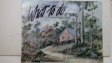
Brochure - Tourism, What to do - Souvenir Holiday Guide to North-Eastern Victoria
... Mt Beauty began as a construction town and was to be sold off but tourism became promising so the SECV handed the town over to the Bright Shire, houses were sold and businesses commenced. From the early 1960s...Mt Beauty began as a construction town and was to be sold off but tourism became promising so the SECV handed the town over to the Bright Shire, houses were sold and businesses commenced. From the early 1960s ...The Kiewa Valley has promoted itself as a tourist hot spot since the Kiewa Hydro Electric Scheme concluded. Mt Beauty began as a construction town and was to be sold off but tourism became promising so the SECV handed the town over to the Bright Shire, houses were sold and businesses commenced. From the early 1960s the town promoted itself and Falls Creek as a tourist destination. The Kiewa Valley Accommodation group combined with the local advertisers to publish this brochure.This brochure promotes tourism all year round promoting the local businesses enabling them to succeed. As tourism is the main industry in Mt Beauty and Falls Creek since the Kiewa Hydro Electric Scheme finished, this advertising is important. It is interesting to note the businesses - their type, their location and the comparison with those in the area now.19 black and white pages including maps and advertisements. Cover is a 'washed' color of a hut in the bush. The title is in black across the top and at the bottom right hand corner. The front cover is in 'landscape' format but the rest of the book is 'portrait'.mt beauty; falls creek; kiewa valley; tourism; north east victoria -
 Kiewa Valley Historical Society
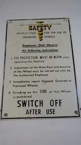
Sign - SECV, Safety - Grinding Wheels
... Kiewa Valley Historical Society Mount Beauty Information Centre 31 Bogong High Plains Rd Mt Beauty high-country The State Electricity Commission of Victoria produced and displayed safety signs for their employees during the construction of the Kiewa Hydro Electric Scheme. KHES was constructed from the late 1940s to early 1960s and included the construction of Mt Beauty and Bogong townships. ...The State Electricity Commission of Victoria produced and displayed safety signs for their employees during the construction of the Kiewa Hydro Electric Scheme.KHES was constructed from the late 1940s to early 1960s and included the construction of Mt Beauty and Bogong townships. Safety was a concern for the SECV towards its workers. Metal black print on white background with yellow 'emphasis' at the top - 'Safety'. "Instructions for the use of / Grinding Wheels". There is a circular hole in each corner with a black frame around the perimeter.state electricity commission of victoria, kiewa hydro electric scheme, safety sign, grinding wheels -
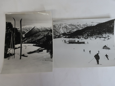 Kiewa Valley Historical Society
Photos x2 - Views of Skiing at Falls Creek
... construction of the KHES. Falls Creek village skiing snow sports Laurie Richards On the back reference to Laurie Richards photographer. 2 Black and white photos of Falls Creek during winter. 1. 5 buildings in Falls Creek Bowl including the Frying Pan Inn, Bogong Ski Club and Cummings Ski Hire and about 20 skiers on the slopes. Photo is taken from the bottom of the Summit T-bar looking towards the Gully chair and part of the Village T-bar. 2. View taken from Falls Creek village looking towards Spion Kop. 1960s ...Falls Creek is a resort town in northeastern Victoria. Its development began during the construction of the Kiewa Hydro Electric Scheme by the SECV in the late 1940s. The resort continued to develop becoming a destination all year round for skiing, bush walking and cycling. Falls Creek began to develop during the construction of the KHES.2 Black and white photos of Falls Creek during winter. 1. 5 buildings in Falls Creek Bowl including the Frying Pan Inn, Bogong Ski Club and Cummings Ski Hire and about 20 skiers on the slopes. Photo is taken from the bottom of the Summit T-bar looking towards the Gully chair and part of the Village T-bar. 2. View taken from Falls Creek village looking towards Spion Kop. 1960s cable binding skis in the foreground.On the back reference to Laurie Richards photographer.falls creek village, skiing, snow sports, laurie richards -
 Kiewa Valley Historical Society
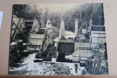
Photos: SECV Construction
... 1960s. Dams, Power Stations, towns, etc. were built during this time These photos show a lot of detail of the work involved in constructing large structures eg. power stations, dams etc. Also they give an insight into safety eg. clothing etc. at the time. These photos were displayed on the walls of the hotel when the building was the SEC Workmans Club KHES Construction ...The SECV constructed the Kiewa Hydro Electric Scheme from the late 1940s to the early 1960s. Dams, Power Stations, towns, etc. were built during this timeThese photos show a lot of detail of the work involved in constructing large structures eg. power stations, dams etc. Also they give an insight into safety eg. clothing etc. at the time. These photos were displayed on the walls of the hotel when the building was the SEC Workmans Club x12 Most of them framed. Large black and white photos of construction of the Kiewa Hydro Electric Scheme: 1. Clover Dam Construction 2. Clover Dam Construction suspended on a crane 3. Power Station Clover Dam 4. Hauling tunnel muck. Tunnel "Ruston" locomotive on rail entrance.5. McKay Power Station 6. Connecting the headrace pipe to turbo turbines - large pipes and workman (double pipe) bifurcate pipes. 7. Installing a generator - seven workmen with hard hats (assembling). 8. V3536 number plate - fire fighting truck - filling up with water. 9. 1939 after bushfire. 10. West Kiewa Power Station - labelled. 11. Lining the portal of a tunnel 12. Camp and offices on left, tunnel entrance on right.khes, construction of khes -
 Kiewa Valley Historical Society
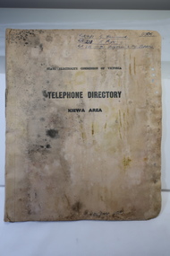
Book - Telephone Directory of the Kiewa Area, State Electricity Commission of Victoria -Telephone Directory - Kiewa Area
... The State Electricity Commission produced a Telephone directory for each of its construction sites during the construction of the Kiewa Hydro Electric Scheme during the 1950s to early 1960s. ...Kiewa Valley Historical Society Mount Beauty Information Centre 31 Bogong High Plains Rd Mt Beauty high-country The State Electricity Commission produced a Telephone directory for each of its construction sites during the construction of the Kiewa Hydro Electric Scheme during the 1950s to early 1960s. ...The State Electricity Commission produced a Telephone directory for each of its construction sites during the construction of the Kiewa Hydro Electric Scheme during the 1950s to early 1960s. The telephones were linked via the Switchboard. The booklet includes instructions for operating.The SECV constructed the KHES during the 1950s. It included construction sites on the Bogong High Plains and the townships of Bogong and Mt Beauty. It also connected the Scheme with the outside world and was operated through the switchboard which was located in Mt Beauty. This booklet also gives names of staff and some workmen - their occupation and their whereabouts of work at the time. Cardboard cover with pages inside bound by metal clasp. Pages divided with tabbed headings:- Bogong, Mt Beauty, West Kiewa, McKay Creek Howmans, Rocky Valley Langford's Gaptelephone directory kiewa hydro electric scheme, kiewa hydro electric scheme telephones -
 Kiewa Valley Historical Society
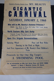
Poster - Mt Beauty Gigantic Carnival, 1960
... The community began planning the building of a swimming pool at Mt Beauty in the early 1960s and held events to raise money for it. The building of a swimming pool in Mt Beauty is part of the construction town's development and demonstrates the support of the community, especially the Mt Beauty and District Progress Association, and the SECV. ...The residents of Mt Beauty and the Kiewa Valley swam in the local East and West Kiewa Rivers. The community began planning the building of a swimming pool at Mt Beauty in the early 1960s and held events to raise money for it. The building of a swimming pool in Mt Beauty is part of the construction town's development and demonstrates the support of the community, especially the Mt Beauty and District Progress Association, and the SECV.Yellowed paper with black print dated Saturday, January 2, 1960 advertising the events for the day at Mt Beauty. Proceeds to the Swimming Pool.mt beauty swimming pool, carnival, mt beauty and district progress association -
 Kiewa Valley Historical Society
Photo - Kiewa Crescent Mt Beauty Circa 1960s
... construction of the Kiewa Hydro Electric Scheme. This photo shows the shops and cars in Kiewa St, Mt Beauty and the houses and Chalet in the background in the early 1960s. ...Mt Beauty was constructed by the SECV in the late 1940s. Built as a construction town for workers and their families during the construction of the Kiewa Hydro Electric Scheme. This photo shows the shops and cars in Kiewa St, Mt Beauty and the houses and Chalet in the background in the early 1960s.Large black and white photo taken from Lakeside Avenue end near the Post Office and looking towards the Chalet and Mt Beauty hill.Stamp in purple: "Please quote / No. LH1399 / when ordering / Laurie Richards / JW 1528"mt beauty township, kiewa st mt beauty, shops and cars in the 1960s mt beauty. -
 Kiewa Valley Historical Society
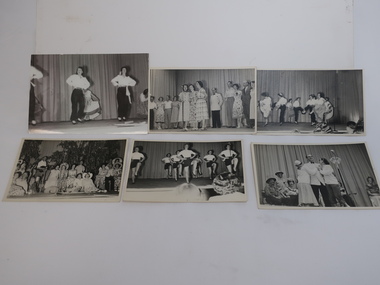
Photos - x3 Mt Beauty Drama Club and x2 Mt Beauty Ladies Gymnasium group
... 1960s. It was an alternative to sport and was before tv was available. This activity is of historic and social significance and can be compared with activities of today especially as Mount Beauty was built as a construction town for the Kiewa Hydro Electric Scheme and is now a small town with the added influence of tourism. ...The Mt Beauty Drama Group held concerts/ pantomimes at the Mt Beauty Community Centre. It was a valuable social outlet for the members because at that time the only entertainment in Mount Beauty was the pictures on a Saturday night. It was also an alternative to playing sport for some. It was formed in 1958 and expanded to include 20 ladies and 8 men. It ceased in the 1970s. Ref. "Below Bogong - A History of Mount Beauty" Chapter 8, Pages 252-254.The Drama Club performed and entertained the Mt Beauty community during their leisure time during the 1950s and 1960s. It was an alternative to sport and was before tv was available. This activity is of historic and social significance and can be compared with activities of today especially as Mount Beauty was built as a construction town for the Kiewa Hydro Electric Scheme and is now a small town with the added influence of tourism. x6 Black and White Photos of groups of adults performing c 1950sOn the back in pencil of one photo - "AMcC Collection / Pantomime in MB Community Centre"mt beauty drama group -
 Kiewa Valley Historical Society
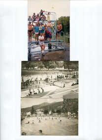
Photos - x 2 Mt Beauty Swimming Pool
... 1960s and opened on 7th January 1964. Currently the main pool is 'partially' heated and the area has a splash area for the children. Details of the time line and people involved are given on the typed sheets. See. "Below Bogong - A History of Mount Beauty" compiled by Di Edmondson. Chapter 9, Pages 295-296. The detail on the typed sheets gives in details the steps taken by the community to achieve the completion of the swimming pool. An example of the effort the community put in to achieve the construction ...The Mt Beauty swimming pool was first constructed in the early 1960s and opened on 7th January 1964. Currently the main pool is 'partially' heated and the area has a splash area for the children. Details of the time line and people involved are given on the typed sheets. See. "Below Bogong - A History of Mount Beauty" compiled by Di Edmondson. Chapter 9, Pages 295-296. The detail on the typed sheets gives in details the steps taken by the community to achieve the completion of the swimming pool. An example of the effort the community put in to achieve the construction of the town's swimming pool. This activity is of historic and social significance and can be compared with activities of today especially as Mt Beauty was built as a construction town for the Kiewa Hydro Electric Scheme and is now a small town with the added influence of tourism. Science has also had an impact over the years as pools can be heated according to demand and budget.Two black and white photos of people swimming in a pool and one coloured photo of people standing on a diving board. 6 typed pages of varying sizes stapled at the top right hand corner titled 'Off with the old and on with the new" - a history of the construction of the swimming pool. AM Collectionmt beauty swimming pool -
 Kiewa Valley Historical Society
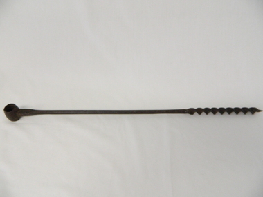
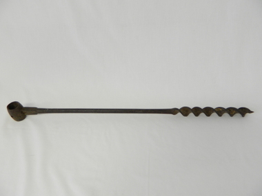
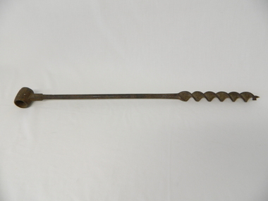
Drill Auger, Circa early 1900s
... construction implement. The manufacturer being a Scottish tool company is very significant in the era when this hole maker was in high demand. British steel products were of high grade and had a good record of reliability. The reliability of any tool was a solid factor for farmers and tradesmen in this semi-isolated region (Circa early 1900s) within the Kiewa Valley and its regional area. This factor,although not as crucial, post 1960s ...This item wasused before diesel, electric and battery drilling apparatus were used by farmers, and other trades requiring a portable yet reliable method of drilling holes. As this item is a 3/4 inch hole drill it would be suitable for fencing and providing holes for structural studs. As with all outdoor farm equipment, man power was required (be it the farmer or farm hands). Fitness of the operator was at a high standard but protective gloves were not highly thought of as it was before occupational, health and safety regulations became mandatory over all manual handling activities, be they on rural properties or town/city factories. This period was one where the male ego was at its pinnacle i.e. the harder the tasks the more of a man was required. Hard manual work was not only the "way to go" but also a necessity. Evolution of cheap portable electric/battery powered tools opened up a more efficient method available, especially to those with less muscle strength. This item personifies the rugged environment of the rural workplace. The Kiewa Valley with its main emphasis on farming and grazing provided ample opportunity to use this construction implement. The manufacturer being a Scottish tool company is very significant in the era when this hole maker was in high demand. British steel products were of high grade and had a good record of reliability. The reliability of any tool was a solid factor for farmers and tradesmen in this semi-isolated region (Circa early 1900s) within the Kiewa Valley and its regional area. This factor,although not as crucial, post 1960s, when Asian manufacturers entered the market place and produced cheaper tools and transportation and supplies was more frequent and reliable, the need for the more expensive British made tools diminished considerably. After the influx of tradesmen from war torn Europe (post 1945) and the increased availability of tradesmen in the Kiewa Valley and its region the price of tools was and still is not as crucial and the cost of all required tools has become a minimal part of the equation. It is only with the emerging younger trades person, farmer and grazier, who have more, "one eye on production costs" and no "old ties to the motherland" inert mind set that quality tools such as this auger and other hand tools "must be made to last a life time" is no longer part of the modern work environment.This cast iron, hand operated Auger has a short barrel shaped cylinder at one end (known as the "Eye") and at the other end a Helical screw blade (screws the cutting edge into wooden material, thereby creating a hole 3/4 inch diameter in the wood) . The barrel section at the top permits a metal or wooden leverage plank to be inserted. The main rod has a 180mm long cutting/screw blade running from the bottom up towards the "eye" end. From the end of the screw blade to the handle is 380mm and cylindrical, but this changes at 550mm from the "eye" end to a 14mm x 10mm rectangular shape shaft.This shaft end is welded to the "Eye".On the shaft below the "eye" is stamped " MATHESON GLASGOW" on the front side and a spade (cards) symbol on the back.auger, hand drill, fencing, tool, rural trades, brace & bit -
 Kiewa Valley Historical Society
Drill Auger, Circa early 1900's
... construction implement. The manufacturer being a Scottish tool company is very significant in the era when this hole maker was in high demand. British steel products were of high grade and had a good record of reliability. The reliability of any tool was a solid factor for farmers and tradesmen in this semi-isolated region (Circa early 1900s) of the Kiewa Valley and its regional area. This factor,although not as crucial, post 1960s ...This item was before diesel, electric and battery drilling apparatus were used by farmers, and other trades requiring a portable yet reliable method of drilling holes. As this item is a 3/4 inch hole drill it would be suitable for fencing and providing holes for structural studs. As with all outdoor farm equipment, man power was required (be it the farmer or farm hands). Fitness of the operator was at a high standard but protective gloves were not highly thought of as it was before occupational, health and safety regulations became mandatory over all manual handling activities, be they on rural properties or town/city factories. This period was one where the male ego was at its pinnacle i.e. the harder the tasks the more of a man was required. Hard manual work was not only the "way to go" but also a necessity. Evolution of cheap portable electric/battery powered tools opened up a more efficient method available, especially to those with less muscle strength.This item personifies the rugged environment of the rural workplace. The Kiewa Valley with its main emphasis on farming and grazing provided ample opportunity to use this construction implement. The manufacturer being a Scottish tool company is very significant in the era when this hole maker was in high demand. British steel products were of high grade and had a good record of reliability. The reliability of any tool was a solid factor for farmers and tradesmen in this semi-isolated region (Circa early 1900s) of the Kiewa Valley and its regional area. This factor,although not as crucial, post 1960s, when Asian manufacturers entered the market place and produced cheaper tools and transportation and supplies was more frequent and reliable, the need for the more expensive British made tools diminished considerably. After the influx of tradesmen from war torn Europe (post 1945) and the increased availability of tradesmen in the Kiewa Valley and its region the price of tools is not as crucial and the cost of all required tools has become a minimal part of the equation. It is only with the emerging younger trades person, farmer and grazier, who have more, "one eye on production costs" and no "old ties to the motherland" inert mind set that quality tools such as this auger and other hand tools "must be made to last a life time" is no longer part of the modern work environment.This cast iron hand operated drill, has a short barrel-shaped cylinder, known as "the eye" welded across the main rod and is 30mm in circumference. It also has a hole drilled to allow a screw to be fastened onto the hand stock ( not available).The main rod is solid for 400mm and then has been flattened and coiled (Helical screw blade) for another 200mm. At the end of the larger screw blade there is a smaller gauged starter blade with a pointer thread 15mm long. This Auger produces a 1/8th inch hole (metric measurement not used at time of manufacture) See KVHS 0469 for 3/4 inch hole and KVHS 0471 for another 1/8th inch hole.A number 5 stamped on the flat sideauger, hand drill, fencing, tool, rural trades, brace & bit -
 Kiewa Valley Historical Society
Drill Auger, Circa early 1900's
... construction implement. The manufacturer being a Scottish tool company is very significant in the era when this hole maker was in high demand. British steel products were of high grade and had a good record of reliability. The reliability of any tool was a solid factor for farmers and tradesmen in this semi-isolated region (Circa early 1900s) of the Kiewa Valley and its regional area. This factor,although not as crucial, post 1960s ...This item was before diesel, electric and battery drilling apparatus were used by farmers, and other trades requiring a portable yet reliable method of drilling holes. As this item is a 3/4 inch hole drill it would be suitable for fencing and providing holes for structural studs. As with all outdoor farm equipment, man power was required (be it the farmer or farm hands). Fitness of the operator was at a high standard but protective gloves were not highly thought of as it was before occupational, health and safety regulations became mandatory over all manual handling activities, be they on rural properties or town/city factories. This period was one where the male ego was at its pinnacle i.e. the harder the tasks the more of a man was required. Hard manual work was not only the "way to go" but also a necessity. Evolution of cheap portable electric/battery powered tools opened up a more efficient method available, especially to those with less muscle strength.This item personifies the rugged environment of the rural workplace. The Kiewa Valley with its main emphasis on farming and grazing provided ample opportunity to use this construction implement. The manufacturer being a Scottish tool company is very significant in the era when this hole maker was in high demand. British steel products were of high grade and had a good record of reliability. The reliability of any tool was a solid factor for farmers and tradesmen in this semi-isolated region (Circa early 1900s) of the Kiewa Valley and its regional area. This factor,although not as crucial, post 1960s, when Asian manufacturers entered the market place and produced cheaper tools and transportation and supplies was more frequent and reliable, the need for the more expensive British made tools diminished considerably. After the influx of tradesmen from war torn Europe (post 1945) and the increased availability of tradesmen in the Kiewa Valley and its region the price of tools is not as crucial and the cost of all required tools has become a minimal part of the equation. It is only with the emerging younger trades person, farmer and grazier, who have more, "one eye on production costs" and no "old ties to the motherland" inert mind set that quality tools such as this auger and other hand tools "must be made to last a life time" is no longer part of the modern work environment.This cast iron hand operated drill, has a short barrel-shaped cylinder, known as "the eye" welded across the main rod and is 30mm in circumference. It also has a hole drilled to allow a screw to be fastened onto the hand stock ( not available).The main rod is solid for 400mm and then has been flattened and coiled (Helical screw blade) for another 200mm. At the end of the larger screw blade there is a smaller gauged starter blade with a pointer thread 15mm long. This Auger produces a 1/8th inch hole (metric measurement not used at time of manufacture) See KVHS 0469 for 3/4 inch hole and KVHS 0470 for another 1/8th inch hole.auger, hand drill, fencing, tool, rural trades, brace & bit -
 Kiewa Valley Historical Society
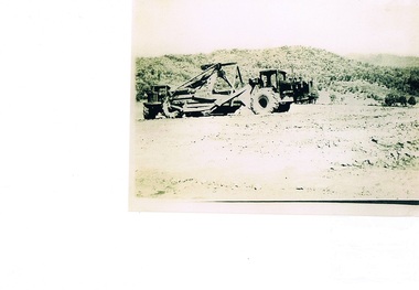
Photograph Tournapull, Tournapull C Scraper/Single Bucket, circa 1950
... 1960s when hydro electricity powered turbines were being constructed in both the Victoria and New South Wales Alps. This was Australia's answer to a non polluting supply of electricity for a fast growing city population. It was at this time that air pollution from coal powered furnaces was becoming more and more under attack by health authorities. This item is part of a visual account of the construction ...The machinery in this photo shows a Tournapull C earth moving machine, one of many during this period Circa 1950 - 1960s when hydro electricity powered turbines were being constructed in both the Victoria and New South Wales Alps. This was Australia's answer to a non polluting supply of electricity for a fast growing city population. It was at this time that air pollution from coal powered furnaces was becoming more and more under attack by health authorities.This item is part of a visual account of the construction of dams and hydro electricity facilities during the early 1950s. It was the beginning of the environmental push not to allow the degrading of Australian Alpine regions. Air pollution of the major cities and the increase in power demands of both industries and population within them required an alternative pollution free alternative electricity supply. These for runners of Hydro electricity generators required both large supplies of machinery and human resources. This construction phase within the region brought not only tradesmen but also unskilled workers to an area which had mainly had farming and mining activities. It was the catalyst for the creation of the smaller towns/villages e.g. Bogong Village, Mount Beauty and Bright.Black and white photograph on Kodak Xtralite II paper.(gloss)paper marking on back Kodak Xtralite II papermining, hydro electricity, victorian alps, construction camps, earth moving machines, secv -
Emerald Museum & Nobelius Heritage Park
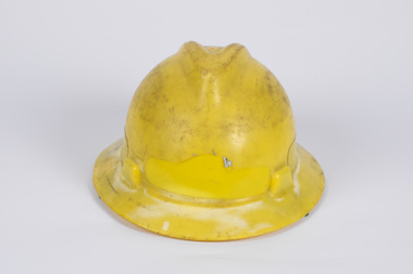
Headwear - Fire Fighters Helmet, MSA, c.1970s
... During the 1960s in Australia, helmets evolved from metal construction to that of polymer and other plastics. ...During the 1960s in Australia, helmets evolved from metal construction to that of polymer and other plastics. ...Helmets protect firefighters from heat, falling objects and cinders. During the 1960s in Australia, helmets evolved from metal construction to that of polymer and other plastics. The manufacturer of this helmet, MSA, was founded in 1914 in the USA. It began as a mine safety company but since expanded into more general worker protection and safety products. The Emerald Fire Brigade was established on 14 March 1941 as the Emerald Bush Brigade. Originally its equipment was stored at Madigan's butcher's shop near the corner of Monbulk Road. The Brigade's first fire station was built around 1945. In 1966, this station was recorded as containing the fire truck and a Land rover pumper, three radio sets, 40 knapsacks, six lengths of hose, helmets, rake hoes and other hand tools. In 2010, the Brigade moved into a new purpose-built building in Monbulk Road.This helmet is an historical artifact worn by members of a crucial volunteer fire fighting service operating in the Emerald district since 1941.Yellow, lightweight, hard plastic or polymer helmet with black leather detachable chin strap with velcro fastening.Inside helmet on a partly torn label: 'MSA / VGARD / Type 2 ...? / STANDARDS AUSTRALIA' Inside the brim at one end engraved: 'MSA'' and at the other end: '1801-1881 / LN70' On front of helmet a label with logo and red lettering: 'CFA' helmets, fire fighting, msa, emerald fire brigade, cfa -
 Emerald Museum & Nobelius Heritage Park
Headwear - Fire Fighters Helmet, MSA, c.1970s
... During the 1960s in Australia, helmets evolved from metal construction to that of polymer and other plastics. ...Emerald Museum & Nobelius Heritage Park 5 Crichton Rd Emerald yarra-valley-and-the-dandenong-ranges During the 1960s in Australia, helmets evolved from metal construction to that of polymer and other plastics. ...During the 1960s in Australia, helmets evolved from metal construction to that of polymer and other plastics. This helmet was donated by the Emerald Fire Brigade which was established on 14 March 1941 as the Emerald Bush Brigade. Originally its equipment was stored at Madigan's butcher's shop near the corner of Monbulk Road. The Brigade's first fire station was built around 1945. In 1966, this station was recorded as containing the fire truck and a Land rover pumper, three radio sets, 40 knapsacks, six lengths of hose, helmets, rake hoes and other hand tools. In 2010, the Brigade moved into a new purpose-built building in Monbulk Road. The manufacturer of this helmet, MSA, was founded in 1914 in the USA. MSA began as a mine safety company but since expanded into more general worker protection and safety products. This helmet is an historical artifact worn by members of a crucial volunteer fire fighting service operating in the Emerald district since 1941.Yellow, lightweight, hard plastic or polymer helmet with black leather detachable chin strap with Velcro fastening. inside the helmet is an adjustable head harnessInside helmet on a partly torn label: 'MSA / VGARD / Type 2 ...? / STANDARDS AUSTRALIA' Inside the brim black pen writing EMERALD SPARE 5 EMERALD at one end engraved: 'MSA'' and at the other end: '1801-1881 On the outside of the helmet there is a yellow reflector on each side and at the front and the back there is evidence of labels that have been removed.helmets, fire fighting, msa, emerald fire brigade, cfa -
 Kiewa Valley Historical Society
Book - Reference Cooking, Mount Beauty Souvenir Cookery Book x2, Circa 1962
... This cookery book was printed in the early 1960s for the purpose of obtaining the necessary funds for the construction of the Mount Beauty swimming pool. ...Kiewa Valley Historical Society Mount Beauty Information Centre 31 Bogong High Plains Rd Mt Beauty high-country This cookery book was printed in the early 1960s for the purpose of obtaining the necessary funds for the construction of the Mount Beauty swimming pool. ...This cookery book was printed in the early 1960s for the purpose of obtaining the necessary funds for the construction of the Mount Beauty swimming pool. The advertisements within this book covers local traders of this time frame, for example, the Bogong Hotel which is no longer operational. the culinary measurements are in Imperial measures(pounds and ounces). The book has sections for continental dishes and sweets (Australian flavour), special dishes for Lent, cakes (farmhouse fruit cake), jams, marmalades (home made), marrow and apple chutney. Some of these recipes are early 20th Century related and in the 2000s are not sought after. The food "take away" lifestyle has been responsible for the demise of a lot of the recipes in this book. The swing away from home grown produce has been not only a lifestyle change but also the faster pace of living in rural areas. The specialisation and redefined development of the local produce store (previously provided everything the rural shopper needed) was a forced move due to larger and cheaper city born fresh food supermarkets. Although there are still some local produce store within the region these will in time vanish. This cookery book was produced just after Mount Beauty was released from an SEC "closed" community in 1961(see KVHS 0134) and the town then had to fend for itself. This book was compiled and produced because the town needed a swimming pool (which possible would have been provided had the SEC still been responsible). The book demonstrates the strong rural psyche of rallying together for the good of all and united for something which would be of benefit to all. The period 1961 to the 1970s was one of great change for Mount Beauty. The SEC protective cage was a blessing for some but a goal for others. The independence that was gained after the SEC left provided for a drastic "make over" in regards to the facilities provided for the "locals" and that for the tourists. An increase in tourist related industries such as snow skiing in winter, hang gliding and gliding, mountain bike rallies, bush walking and horse riding, all of which have supply outlets in the town, has provided a more cosmopolitan atmosphere. These activities and the greater interaction with populations outside of the region has reduced the "hermit" type feel of the town psyche.This recipe book consists of eighty nine pages in black and white print. It contains black and white sketches, recipes of local domestic cooks and advertisements covering local traders. The cover is approximately 280 g/m2 in weight and the pages are at 90 g/m2 in weight. The cover has a design in the style of Abstract Expressionism (period 1950-1960s) of identifiable (clock,jug,fruit,window) and abstract objects in tints of blue and shades of black. This was designed by Cheryl Ryder of the Mount Beauty High School, under supervision of Mr I Baker (Art Teacher)On the foreword(page two and page three) "Mt. Beauty Souvenir Cookery Book First Edition" . This foreword was presented by Rosa Kinnear, President, Ladies' Auxiliary 2nd copy - no inscriptionrecipe, cooking, food, domestic, kitchen, local history, comfort food, pioneer cleaning methods -
 Kiewa Valley Historical Society
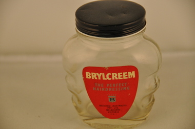
Jar Brylcream- Personal Item, Circa mid 1900s
... 1960s when the freedom loving "hippie culture" had a marked affect upon the city inhabitants but not so strong among rural males. Sexism was still rife in that time frame. This jar of Brylcreem was a part of the (masculine) rural scene for a longer period than that found in the larger towns and cities. The long held "men are men" and "women are women" distinction between the sexes lingered on more in rural areas because of the perceived physical differences, mainly "strength" and perceived tasks such as "men only" activities (heavy farm/mining/construction). ...This product was introduced in an era where the "silky smooth" look was in vogue. From the 1920s on, American and British film stars set the tone of how clean cut (hero type) masculine look attracts the opposite sex faster and in greater quantities than the "unkempt" or natural maintained look. This look was bold and "polished" and had the intended projection that the hair matched the character of "I look after myself and have a high opinion of physical appearances". As fashion goes this slick and well maintained look has circled many times, in and out of history and in Australia in the 1950s this was a prime example. The liberation of the stereo type of both sexes occurred in the 1960s when the freedom loving "hippie culture" had a marked affect upon the city inhabitants but not so strong among rural males. Sexism was still rife in that time frame.This jar of Brylcreem was a part of the (masculine) rural scene for a longer period than that found in the larger towns and cities. The long held "men are men" and "women are women" distinction between the sexes lingered on more in rural areas because of the perceived physical differences, mainly "strength" and perceived tasks such as "men only" activities (heavy farm/mining/construction). The jar of Brylcreem maintained the respectable male look for those special occasions when males "dressed" up and looked clean physically and well behaved (to show respect to the women folk)This glass jar with a glued on,red background, label detailing the product Brylcreem (a men's) hairdressing ointment is empty of its original product. It has been contoured on each side to allow for a man's fingers to comfortably and firmly grip the jar. This form would allow even "greased up" hands to maintain control. The glass thickness is far greater than needed and also added the extra stability to the standing jar. The shape of the jar is a latent attempt to emulate the physique of a fit young man (small waist, expanded and muscled mid rift and large shoulders). The jar does not distract from viewing its contents (clear glass). It has a black gloss screw (on/off) lid made from mild grade steel. The jar holds approximately 200 grams of a thick molasses textured product. On the front red Label; in large white letters "BRYLCREEM" underneath this is in smaller silver print "THE PERFECT HAIRDRESSING" underneath this is a banner type motif with a crown at the top and a black letter "B"in the centre. Below this and in much smaller print are printed in black script "BEECHAM (AUSTRALIA) PTY. LTD. MELBOURNE VICTORIA M A Imen's deportment, toiletries, men's hair styles, physical appearances -
 Emerald Museum & Nobelius Heritage Park
Photograph - Photographs of rebuilding the Wright Trestle Bridge, 1990s
... The building of the original Wright Trestle Bridge in the late 1890s as part of the construction of the narrow-gauge railway from Ferntree Gully to Gembrook, was a significant engineering achievement for its time. The railway (now known as Puffing Billy) was closed in the 1950s. When it re-opened in the 1960s...Emerald Museum & Nobelius Heritage Park 5 Crichton Rd Emerald yarra-valley-and-the-dandenong-ranges The building of the original Wright Trestle Bridge in the late 1890s as part of the construction of the narrow-gauge railway from Ferntree Gully to Gembrook, was a significant engineering achievement for its time. The railway (now known as Puffing Billy) was closed in the 1950s. When it re-opened in the 1960s ...The building of the original Wright Trestle Bridge in the late 1890s as part of the construction of the narrow-gauge railway from Ferntree Gully to Gembrook, was a significant engineering achievement for its time. The railway (now known as Puffing Billy) was closed in the 1950s. When it re-opened in the 1960s it terminated at Emerald Lake. In the 1990s, it was decided to rebuild the section of the line from Emerald Lake to Gembrook - this was completed in 1998. The major project challenge was to rebuild the historic Wright Trestle Bridge which traversed a very steep gully in Wrights Forest, Avonsleigh. These photographs have been provided by Graeme Smith who supplied the concrete to build the foundations of the bridgeThese photos show the foundation stage of the rebuilding of the historic Wright Trestle Bridge as part of the larger reconstruction of the Puffing Billy line from Emerald Lake to Gembrook.Five color photographs all depicting concrete foundations laid up and down a steep gully as part of the rebuilding of the Wright Trestle Bridge.On back of VEMUP1091 3/5, hand-written: 'Graeme Smith / Unloading on / Puffing Billy line / in Wright Forest / Concrete supplied / from P B M Packham'wright trestle bridge, 1998, puffing billy -
 Eltham District Historical Society Inc
Document - Property Binder, 616 Main Road, Eltham; Plum Cottage
... 1960s. Reputedly the house was called Plum Cottage and erected for Harcourt’s mother-in-law. A garage was added in 1959. Charles McNeil died in1971 aged 87: he was the son of Don McNeil and Margaret Arkell. Available rate records from the construction...1960s. Reputedly the house was called Plum Cottage and erected for Harcourt’s mother-in-law. A garage was added in 1959. Charles McNeil died in1971 aged 87: he was the son of Don McNeil and Margaret Arkell. Available rate records from the construction ...Plum Cottage is covered by Heritage Overelay HO256 in the Nillumbuk Planning Scheme This two-lot land holding was created as a subdivision and sold to Charles Stuart McNeil by May 1955. Sometime in the period 1955-1960, the builder-designer, John Harcourt had created a pise house on the site, straddling the two subdivision lots. The designer, John M. Harcourt was a pioneer builder in pise-de-terre and mudbrick in the Eltham Shire, Eltham being synonymous with alternative lifestyles and building practises until the onset of suburbia in the late 20th and early 21st centuries. This hipped-roof house is set high above Main Road on a V-shape plan characteristic of the Arts & Crafts style, with rammed earth or pise walls, timber joinery and a cement tiled roof. The V shape plan was used by important English and Eltham Arts & Crafts designers. The use of natural materials such as stone and timber construction is an essential part of the Arts & Crafts style and Harcourt’s work. So too is the application of the style on both the exterior and interior of the house as a holistic concept. The house adjoins the Lim Joon adobe house built and designed by Alistair Knox in the same era (HO119), thus forming a distinctive pair, both using an uncommon plan form. This house was identified in the Shire of Shire of Eltham Heritage 1992 as contributory to the Eltham Gateway Conservation Area, then proposed as an urban conservation area (now Heritage Overlay Area). Land Ownership Emily Jane Smith of 12 Woodside Street Fitzroy owned Crown Allotments 1 & 2 Sections 14, 27 by August 1918, selling to William Henry Smith of 12 Woodside Street, Nth Fitzroy May 1921. (John) James Isherwood of Main Road, Eltham owned the property by 1928 (the year of his death) with the beneficiary of his estate and next owner of this site being his widow, Minnie Maria Isherwood of Cemetery Road, Eltham. His holding in Main Road included parts of what was described in rate records as allotments1 & 2 Section E6. In the late 1930s, early 1940s her son Alfred John Isherwood was also rated for the land around this site, with the rated nett annual value varying between £2 and £5. Alfred Isherwood also lived at Main Road, Eltham with his wife Ellen: her early death at the age of 24 was reported in the Argus of 1923. Part of the Isherwood land was divided off and sold to Charles Stuart McNeil by May1955. Sometime in the period 1955-1960, the builder-designer, John Harcourt had created a pise house on the site, straddling the two subdivision lots. The house is visible on an aerial photograph from 1960s. Reputedly the house was called Plum Cottage and erected for Harcourt’s mother-in-law. A garage was added in 1959. Charles McNeil died in1971 aged 87: he was the son of Don McNeil and Margaret Arkell. Available rate records from the construction era start in the of the 1970s (1972-3) and list Mr H.C. & M/S A.V. Charity at 616 Main Road Eltham of this property with a nett annual value of $740. More recent valuer's data describes the property as lots 1 & 2 LP25668, located in the Central Riding of Eltham Shire, owned by Ann Valerie Charity and later, in 1990, by the Chincarini family. Building Description This hipped roof 11 .5 square house is set high above Main Road on a characteristic-shape plan and has rammed earth or pise walls, timber joinery and a cement tiled roof. The V-shape plan was used by Important designers such as C.F.A. Voysey (UK) who interpreted medieval domestic architecture as part of the Arts & Crafts style of the late 19th and early 20th centuries. The pise walls are covered with a textured render while the cement roofing tiles are also seen in the Harcourt Hill examples. Reputedly the ceiling joists are of a deep section and span long lengths with no need for hanging beams in the roof space. The ceilings are low and panelled in main rooms with apparently Caneite soft board infill panels between the exposed ceiling beams. These are painted white but may have been stained at one time. The focus of the house is the large living area with its vast random stone fireplace. Significance Plum Cottage is significant to the locality of Eltham because: Historically: • Plum Cottage is closely associated with the important historical theme of earth construction evident in Eltham and elsewhere in the Shire since theear1y Arts & Crafts inspired creations at Penleigh Boyd's The Robins (1912, HO101) and those at Montsalvat (1934-, HO82) but more prominent from the Second War period when earth building in Eltham was promoted in national periodicals as an alternative building method that avoided the building materials shortages of that era; • The choice of the earth building technique also expresses the theme of refuge or alternative living, synonymous with Eltham in the early to mid 20th century; • as a good example of domestic architecture from John Harcourt who was the first major post Second War figure in an important phase of Eltham’s earth building development, using his characteristic Old English or Arts& Crafts style that relies in this case on the pise wall construction, pitched roof forms, exposed ceiling joists, half timbering, random stonework, and panelled internal wall finishes. Architecturally: • Plum Cottage's pise wall construction is uncommon among the early earth-walled structures in the Shire, that are mainly of adobe or mud brick, and as a building material is uncommon among the Shire’s suburban dwellings generally which are clad typically with either fired clay bricks or timber boarding. Aesthetically: • Plum Cottage is a good and well preserved example of a modern Old English or Arts & Crafts style earth-walled building in the Shire • For the proximity of the significant Lim Joon adobe house designed by Alistair Knox adjoining to the north, providing a distinctive earth wall house pair, with uncommon plan forms. Reference Heritage Assessment of Plum Cottage, 616 Main Road, Eltham; Graeme Butler & Associates 2010main road, eltham, property, houses, (john) james isherwood, alfred john isherwood, ann valerie charity, arts and crafts style, charles stuart mcneil, chincarini family, eltham gateway zone, emily jane smith, h.c. charity, heritage assessment, john harcourt, john m. harcourt, lim joon house, main road eltham, minnie maria isherwood, pise construction, plum cottage -
 Eltham District Historical Society Inc
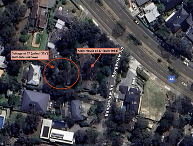
Document - Property Binder, 338 Main Road, Lower Plenty (also 37 Rangeview Road), March 2025
... construction method was only just becoming recognised as an acceptable form in the late 1940s for issuance of a building permit. The house was commenced in 1954, designed by David Newbury and built by David Newbury, Horrie Judd and others. Information from Newbury family friends suggests that a second mudbrick building was constructed in the late 1950s, early 1960s...construction method was only just becoming recognised as an acceptable form in the late 1940s for issuance of a building permit. The house was commenced in 1954, designed by David Newbury and built by David Newbury, Horrie Judd and others. Information from Newbury family friends suggests that a second mudbrick building was constructed in the late 1950s, early 1960s ...EDHS_03095-338 | EDHS_08635-37 338 Main Road Lower Plenty | 37 Rangeview Road, Lower Plenty Original Mudbrick cottage and studio designed and built by Eltham artist, David Alan Newbury See also EDHS_06090 David Newbury (Artist) David Newbury was married to Clare Margaret Newbury. According to the 1954 Electoral Roll they were living at 36A Murphy Street, South Yarra however around 1953 they purchased Lots 3 and 4 of Main Road Lot Plan LP 23911 in Lower Plenty. A building permit, No. 71, was issued 8 December 1953 for a 5-room house of Vertical Board construction, cost £2,840, builder L. Williams, owner D. Newbury of 36 Murphy Cl., South Yarra. The large house was in fact mostly built of mudbrick, the construction method was only just becoming recognised as an acceptable form in the late 1940s for issuance of a building permit. The house was commenced in 1954, designed by David Newbury and built by David Newbury, Horrie Judd and others. Information from Newbury family friends suggests that a second mudbrick building was constructed in the late 1950s, early 1960s for use as an artist studio by Newbury. The building was connected directly to the water mains at the time and was made suitable for living accommodation during the period Newbury was teaching at Bendigo. Apparently he and Claire rented out the main house during their time in Bendigo and would reside in the studio when visiting Melbourne. No permit for this studio was found in the Building Permit Register, Shire of Eltham, 1949-1960. The last recorded entries in the register are dated May 1960. This would suggest that the studio was constructed post May 1960. It is believed the studio was constructed during the latter period of Newbury’s teaching post in Bendigo so possibly late 1960/1961. In 1963 the Newbury’s address in the Electoral Roll has the property recorded as 220 Main Road, Lower Plenty. Between 1967 to 1980 the Electoral Rolls record the property as 338 Main Road. Today the address is 37 Rangeview Road, Lower Plenty. Contents: 1. Extract from 1942 Shire of Eltham Rate Book. Muriel Gladys Reitsma listed as owner 2. Extract from 1984-85 Shire of Eltham Rate Book for Rangeview Road. (No mention of No. 37 so was probably still listed as 338 Main Road.) 3. Certificate of Title, Vol. 5601 Fol. 1120089 - Issued to David James Graham of Lower Plenty, Builder, Heidelberg for Lot 32 Block B on Plan of Subdivision No. 7606, part of Crown Portion Two, Parish of Nillumbik, County of Evelyn, 29 October 1929 4. Certificate of Title, Vol. 8008 Fol. 076 - Issued to David Alan Newbury of 36 Murphy Street, South Yarra, School Teacher for Lot 3 on Plan of Subdivision No. 23911, part of Crown Portion Two, Parish of Nillumbik, County of Evelyn, 29 October 1953. Amended 24 June 1963 to transfer portion for road widening scheme per Country Roads Board Plan 6889 - Cancelled 24 September 1984 5. Certificate of Title, Vol. 9581 Fol. 583 - Issued to Paul Robert Biber and Althea Constance Biber of 139 Lower Heidelberg Road, Ivanhoe for Lot 3 on Plan of Subdivision No. 23911, part of Crown Portion Two, Parish of Nillumbik, County of Evelyn, 24 September 1984. Derived from Vol. 8008 Fol. 076 L276994V - Cancelled 20 Nov 1992 when subdivided from one to two lots in Vol 10092 Fol. 192 and Vol. 10092 Fol. 193; LP222467B 6. Certificate of Title, Vol. 10092 Fol. 192 - Transfer to Lawrie Mein of 20 Dewar Drive, Hurstbridge of Lot 1 on Plan of Subdivision No. 222467B, lodged 17 Feb 1993, Registered 29 March 1996. Parent Titles Vol 08008 Fol 077, Vol 09581 Fol 583 7. Survey Field Notes of Part of Crown Portion 2, Parish of Nillumbik, County of Evelyn - Portion of land bounded by New Eltham Road. Application 23911 dated 8 Sep 1952 with appended Surveyor Field notes per Application 7098; R.D. Steele, Licensed Surveyor, 18 August 1950 8. Survey Field Notes of Part of Crown Portion 2, Parish of Nillumbik, County of Evelyn - Portion of land bounded by Main Road and Rangeview Road; 2 Lot subdivisions, Vol. 9581 Fol. 583 Part Lot 3 on LP 23911 and Vol. 8008 Fol, 077 Lot 4 on LP 23911; Application 221805 dated 27 November 1989; W.J. Goodison, Licensed Surveyor, and attached Surveyor's Report dated 6 June 1990 (Withdrawn) 9. Survey Field Notes of Part of Crown Portion 2, Parish of Nillumbik, County of Evelyn - Portion of land bounded by Main Road and Rangeview Road; 2 Lot subdivisions, Vol. 9581 Fol. 583 Part Lot 3 on LP 23911 and Vol. 8008 Fol, 077 Lot 4 on LP 23911; Application 222467 dated 20 November 1992 (221805 resubmitted); W.J. Goodison, Licensed Surveyor, and attached Surveyor's Report dated 6 June 1990 Notes: Items 1 to 6 donated electronically Items 7 to 9 sourced from LASSI - SPEAR, Department of Transport and Planning, Victoria State Government, https://maps.land.vic.gov.au/lassi/SpearUI.jsp main road, property, mudbrick, david newbury, phoebe mason collection, rate books, shire of eltham, certificate of title, survey plan, 37 rangeview road, 338 main road, application 23911, lower plenty, map, surveyor field notes, application 221805, application 222467 -
 Bendigo Historical Society Inc.
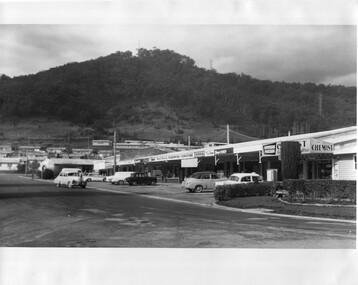
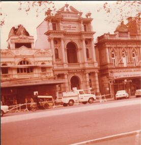
Photograph - GREATER BENDIGO PHOTO COLLECTION: PALL MALL
... 1960s. The National Bank and the Bank of NSW buildings. Near the Beehive. Some construction work going on at the front....1960s. The National Bank and the Bank of NSW buildings. Near the Beehive. Some construction work going on at the front. ...Photograph.Pall Mall, Bendigo 1960s. The National Bank and the Bank of NSW buildings. Near the Beehive. Some construction work going on at the front.bendigo, banks, national bank -
 The Beechworth Burke Museum
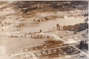
Photograph, 1960
... construction...#beechworth...australian landscape...Beechworth 1960s...Beechworth Lake Lake Lake Sambell construction #beechworth australian landscape Beechworth 1960s Victoria Black and white reproduced rectangular photograph print on paper. ...Taken in 1960, depicted is the construction of Lake Sambell, looking west across the lake. Lake Sambell is a beautiful Victorian recreation lake and urban park with a unique history. It was created in the mid-1800s by the Rocky Mountain Mining company during the gold rush era and used as a mining site until the early 1900s, which brought Europeans into the area. It was turned into a reserve for residents in 1920 and is considered an icon of Beechworth as it represents the development of the community, human endeavour, and the spirit of the landscape.This photograph represents additional construction to Lake Sambell as a recreational reserve.Black and white reproduced rectangular photograph print on paper.beechworth lake, lake, lake sambell, construction, #beechworth, australian landscape, beechworth 1960s, victoria -
 Halls Gap & Grampians Historical Society
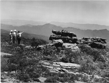
Photograph - B/W, C 1960s
... A track to the top of Mt William existed many years before, an all weather road was constructed in the early 1960s Not only did engineers and construction workers enjoy some spectacular scenery during "smokos" but so have thousands of tourists Some even experiencing the freezing gale force winds which greeting Major Thomas Mitchell and his party in July 1836s...Halls Gap & Grampians Historical Society Centennial Hall 117-119 Grampians Road Halls Gap grampians A track to the top of Mt William existed many years before, an all weather road was constructed in the early 1960s Not only did engineers and construction workers enjoy some spectacular scenery during "smokos" but so have thousands of tourists Some even experiencing the freezing gale force winds which greeting Major Thomas Mitchell and his party in July 1836s ACCESS ROUTES Walking track Roads Mount William WMT (Wimmera Mail Times} Photo shows 3 men looking over to Wonderland Range from Mt William. ...A track to the top of Mt William existed many years before, an all weather road was constructed in the early 1960s Not only did engineers and construction workers enjoy some spectacular scenery during "smokos" but so have thousands of tourists Some even experiencing the freezing gale force winds which greeting Major Thomas Mitchell and his party in July 1836sPhoto shows 3 men looking over to Wonderland Range from Mt William. Two men are wearing hard hats The third man a felt hat - he is pointing to a point in the distanceWMT (Wimmera Mail Times}access routes, walking track, roads, mount william