Showing 92 items matching "construction and demolition"
-
 Eltham District Historical Society Inc
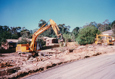
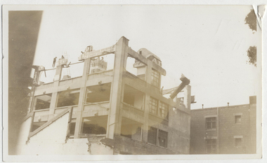
Photograph, Demolition of Eltham Stock Feed in preparation for construction of Le Pine Funeral Home, cnr Main Road and York Street, Eltham, March 1998, 1998
... Demolition of Eltham Stock Feed in preparation for construction of Le Pine Funeral Home, cnr Main Road and York Street, Eltham, March 1998...Eltham District Historical Society Inc 728 Main Rd Eltham melbourne Le Pine Funeral Home Main Road York Street Colour photograph Demolition of Eltham Stock Feed in preparation for construction of Le Pine Funeral Home, cnr Main Road and York Street, Eltham, March 1998 Photograph ...Colour photographle pine funeral home, main road, york street -
 4th/19th Prince of Wales's Light Horse Regiment Unit History Room
Booklet, The Division in Battle Pamphlet No 6 Engineers 1966, 1966
... Soft covered booklet covering the organisation, command & employment, operations, constructions, demolitions, mine warfare etc by Engineers. 3 copies...4th/19th Prince of Wales's Light Horse Regiment Unit History Room 4/19 PWLH Regiment, Building 78 Simpson Barracks Macleod melbourne military engineering 7610-66-024-4973 Soft covered booklet covering the organisation, command & employment, operations, constructions, demolitions, mine warfare etc by Engineers. 3 copies The Division in Battle Pamphlet No 6 Engineers 1966 Booklet Booklet ...Soft covered booklet covering the organisation, command & employment, operations, constructions, demolitions, mine warfare etc by Engineers. 3 copies7610-66-024-4973military engineering -
 Whitehorse Historical Society Inc.
Photograph, Mitcham State school
... Coloured photo of demolition of Mitcham State school (junior school) Mitcham Road, Mitcham to make way for construction of Safeway shopping centre and carpark...Whitehorse Historical Society Inc. 2-10 Deep Creek Road Mitcham melbourne mitcham state school no. 2904 Mitcham Coloured photo of demolition of Mitcham State school (junior school) Mitcham Road, Mitcham to make way for construction of Safeway shopping centre and carpark Mitcham State school Photograph Photograph ...Coloured photo of demolition of Mitcham State school (junior school) Mitcham Road, Mitcham to make way for construction of Safeway shopping centre and carparkmitcham state school no. 2904, mitcham -
Port Melbourne Historical & Preservation Society
Photograph - Conversion of UDL Distillery to apartments, Pickles Street, Janet Bolitho, 2002 - 2003
... Taken from Rouse St .01- Wall, Pickles St .02 - Crane and demolition .03 - Blue rear of aprtments under construction .04 - Interior view of construction site...Taken from Rouse St .01- Wall, Pickles St .02 - Crane and demolition .03 - Blue rear of aprtments under construction .04 - Interior view of construction site Photograph Conversion of UDL Distillery to apartments, Pickles Street Janet Bolitho ...Four colour photographs of the conversion of UDL Distillery in Pickles Street to apartments. Taken from Rouse St .01- Wall, Pickles St .02 - Crane and demolition .03 - Blue rear of aprtments under construction .04 - Interior view of construction sitebuilt environment - commercial, joshua brothers distillery, udl, pickles street, id apartments -
Port Melbourne Historical & Preservation Society
Photograph - Demolition east wing (finger pier) and construction of truck bay and ramp for Abel Tasman and Spirit of Tasmania, Station Pier, Port Melbourne, Ron Laing, 1986 - 1999
... A set of fifty-three colour photographs c1992 covering the demolition of the east wing or finger pier of Station Pier, and construction of the new truck bay and ramp for the Abel Tasman and Spirit of Tasmania....Photograph Demolition east wing (finger pier) and construction of truck bay and ramp for Abel Tasman and Spirit of Tasmania, Station Pier, Port Melbourne Ron Laing ...Part of Ron Laing's collection of photographs taken around Port Melbourne over a thirteen year period. Donated to the PMH&PS by the photographer.A set of fifty-three colour photographs c1992 covering the demolition of the east wing or finger pier of Station Pier, and construction of the new truck bay and ramp for the Abel Tasman and Spirit of Tasmania.piers and wharves - station pier, ron laing, tt-line co pty ltd -
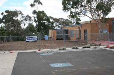 Sunbury Family History and Heritage Society Inc.
Photograph, Rosa McCall, 2nd January 2018
... A coloured photograph of a fenced site with a flat-roofed cream brick building adjacent to an area that has a been cleared in preparation for construction. A demolition sign is attached to the wire fence. ...Libraries Global Learning Centre Sunbury Hume City Council Macedon Street Sunbury Library A coloured photograph of a fenced site with a flat-roofed cream brick building adjacent to an area that has a been cleared in preparation for construction. A demolition sign is attached to the wire fence. ...The former Sunbury Library was demolished and the empty site is ready for the construction of the new library. The existing building housed the George Evans Museum. A more modern Global Learning Centre is planned to be built on the site.A coloured photograph of a fenced site with a flat-roofed cream brick building adjacent to an area that has a been cleared in preparation for construction. A demolition sign is attached to the wire fence. Gum trees are growing in three background.libraries, global learning centre, sunbury, hume city council, macedon street, sunbury library -
![Newspaper - Newspaper Clipping - Digital Image, The Valley Voice, [Greensborough Plaza under construction 1978], 06/07/1978](/media/collectors/4f729f5697f83e03086015b8/items/674aaeae8f48af8ae71c379f/item-media/674aaeee8f48af8ae71c4664/item-fit-380x285.jpg?cb=6) Greensborough Historical Society
Greensborough Historical SocietyNewspaper - Newspaper Clipping - Digital Image, The Valley Voice, [Greensborough Plaza under construction 1978], 06/07/1978
... The Greensborough Centre (now known as Greensborough Plaza) under construction. These two photographs from the local newspaper show initial groundwork and demolition of previous buildings....Greensborough Historical Society 34A Glenauburn Road Lower Plenty Lower Plenty melbourne The Greensborough Centre (now known as Greensborough Plaza) under construction. These two photographs from the local newspaper show initial groundwork and demolition of previous buildings. greensborough plaza greensborough centre Digital copy of newspaper article [Greensborough Plaza under construction 1978] Newspaper Newspaper Clipping - Digital Image The Valley Voice ...The Greensborough Centre (now known as Greensborough Plaza) under construction. These two photographs from the local newspaper show initial groundwork and demolition of previous buildings.Digital copy of newspaper articlegreensborough plaza, greensborough centre -
Glen Eira Historical Society
Document - Glen Eira
... Brief unsigned and undated notes about ‘Glen Eira’ noting address, date of construction and demolition and why the owner, Henry Ricketson, sold the property to F. ...Brief unsigned and undated notes about ‘Glen Eira’ noting address, date of construction and demolition and why the owner, Henry Ricketson, sold the property to F. ...This file contains one item. 1. Brief unsigned and undated notes about ‘Glen Eira’ noting address, date of construction and demolition and why the owner, Henry Ricketson, sold the property to F. G. Sargood.‘glen eira’, kooyong road, caulfield, ricketson henry, sargood f. g. -
 Sunshine and District Historical Society Incorporated
Photograph - Sunshine Photographs 2025, John Alchin, 2025
... 5637.01 - Durham Road 121 - 123 Sunshine - Vietnamese Museum Nearing Construction Completion December 2025.JPG 5637.02 - Watt Street 22 Sunshine - Fire Cleanup 3rd May 2025 Photo 01.JPG 5637.03 - Alexandra Avenue Sunshine - Sunshine Municipal Offices Demolition 2025 Photo 01.JPG 5637.04 - Alexandra Avenue Sunshine - Sunshine Municipal Offices Demolition 2025 Photo 06.JPG 5637.05 - Alexandra Avenue Sunshine - Sunshine Municipal Offices Demolition 2025 Photo 07.JPG 5637.06 - Anderson Road 133 Sunshine - New Units 2025 Photo 01.jpg 5637.07 - Watt St 8 Sunshine - Channel of Pearce Church 2025.JPG ...Sunshine Durham Road Watt Street Alexandra Avenue Anderson Road Sunshine Municipal Offices Channel of Pearce Church Vietnamese Museum 5637.01 - Durham Road 121 - 123 Sunshine - Vietnamese Museum Nearing Construction Completion December 2025.JPG 5637.02 - Watt Street 22 Sunshine - Fire Cleanup 3rd May 2025 Photo 01.JPG 5637.03 - Alexandra Avenue Sunshine - Sunshine Municipal Offices Demolition 2025 Photo 01.JPG 5637.04 - Alexandra Avenue Sunshine - Sunshine Municipal Offices Demolition 2025 Photo 06.JPG 5637.05 - Alexandra Avenue Sunshine - Sunshine Municipal Offices Demolition 2025 Photo 07.JPG 5637.06 - Anderson Road 133 Sunshine - New Units 2025 Photo 01.jpg 5637.07 - Watt St 8 Sunshine - Channel of Pearce Church 2025.JPG Digital photographs Photograph Sunshine Photographs 2025 John Alchin ...These photographs provide a visual record of assorted buildings, street views, and notable locations throughout Sunshine in 2025.This collection of photographs preserves a visual record of Sunshine 2025.5637.01 - Durham Road 121 - 123 Sunshine - Vietnamese Museum Nearing Construction Completion December 2025.JPG 5637.02 - Watt Street 22 Sunshine - Fire Cleanup 3rd May 2025 Photo 01.JPG 5637.03 - Alexandra Avenue Sunshine - Sunshine Municipal Offices Demolition 2025 Photo 01.JPG 5637.04 - Alexandra Avenue Sunshine - Sunshine Municipal Offices Demolition 2025 Photo 06.JPG 5637.05 - Alexandra Avenue Sunshine - Sunshine Municipal Offices Demolition 2025 Photo 07.JPG 5637.06 - Anderson Road 133 Sunshine - New Units 2025 Photo 01.jpg 5637.07 - Watt St 8 Sunshine - Channel of Pearce Church 2025.JPG sunshine, durham road, watt street, alexandra avenue, anderson road, sunshine municipal offices, channel of pearce church, vietnamese museum -
 Heidelberg Golf Club
Album - Photograph Album, Heidelberg Golf Club, HGC Clubhouse redevelopment 1998, 1998
... Album containing about 186 color photographs of Heidelberg Golf Club's clubhouse redevelopment 1998, including 22 photos of old clubhouse; 94 photos of demolition and construction, 10 of landscaping after the building works and 60 of Opening Day celebrations....Heidelberg Golf Club 8 Main Road Lower Plenty 3093 Album containing about 186 color photographs of Heidelberg Golf Club's clubhouse redevelopment 1998, including 22 photos of old clubhouse; 94 photos of demolition and construction, 10 of landscaping after the building works and 60 of Opening Day celebrations. ...Album containing about 186 color photographs of Heidelberg Golf Club's clubhouse redevelopment 1998, including 22 photos of old clubhouse; 94 photos of demolition and construction, 10 of landscaping after the building works and 60 of Opening Day celebrations.Album #6 in the photograph collection at HGCDark green hard cover album. Contains approx. 186 colour photographs 15x10cm.heidelberg golf club, clubhouse redevelopment 1998, club house opening 1998 -
 Puffing Billy Railway
2'6" gauge Fox Freight Bogie, 1890s
... 'FOX" Built Fox freight Bogie imported by the Victorian Railways First patented by Englishman Samson Fox in 1893, the Fox style bogie carried virtually all the rolling stock on the Victorian Railways 4 narrow gauge lines from construction to demolition....Puffing Billy Railway 1 old monbulk road Belgrave yarra-valley-and-the-dandenong-ranges 'FOX" Built Fox freight Bogie imported by the Victorian Railways First patented by Englishman Samson Fox in 1893, the Fox style bogie carried virtually all the rolling stock on the Victorian Railways 4 narrow gauge lines from construction to demolition. Historic - Narrow Gauge Railway - Fox freight Bogie imported and used by the Victorian Railways fox bogie puffing billy victorian railways Pressed Steel Frame Bogie made of iron and Wrought iron 2'6" gauge Fox Freight Bogie Fox Solid Pressed Steel Company ...'FOX" Built Fox freight Bogie imported by the Victorian Railways First patented by Englishman Samson Fox in 1893, the Fox style bogie carried virtually all the rolling stock on the Victorian Railways 4 narrow gauge lines from construction to demolition.Historic - Narrow Gauge Railway - Fox freight Bogie imported and used by the Victorian RailwaysPressed Steel Frame Bogie made of iron and Wrought iron fox, bogie, puffing billy, victorian railways -
 St Kilda Historical Society
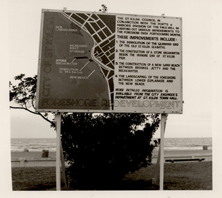
Photograph - St Kilda foreshore, Council notice of redevelopment, c1980s
... The works included the demolition of part of the St Kilda sea baths in 1981 and the construction of a new sand beach....The works included the demolition of part of the St Kilda sea baths in 1981 and the construction of a new sand beach. ...Sign notifying the public that the St Kilda Council in conjunction with the Ports and Harbours Division of the Public Works Department would be redeveloping the St Kilda foreshore. The works included the demolition of part of the St Kilda sea baths in 1981 and the construction of a new sand beach.Black and white photograph, unmounteddavid rae collection, st kilda, st kilda foreshore -
 Eltham District Historical Society Inc
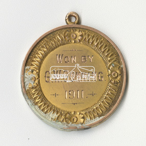
Medallion, Won by G.W. Gunning, 1911; N.G.C., Presented by J.R. Hutchinson, 1911
... Found during demolition of 'lean to' additions to Eltham Primary School Dalton Street building of mud stone 1875 construction during alterations, 21 September 1994. ...Eltham District Historical Society Inc 728 Main Rd Eltham melbourne Found during demolition of 'lean to' additions to Eltham Primary School Dalton Street building of mud stone 1875 construction during alterations, 21 September 1994. ...Found during demolition of 'lean to' additions to Eltham Primary School Dalton Street building of mud stone 1875 construction during alterations, 21 September 1994. Paint appears to have dripped through onto medallion found on floor bearer 4" x 3"Round medallion, brass with paint on surfaces, approximately 25mm diameter and small eyelet at top for chain attachment or similar eltham primary school, eltham state school, g.w. gunning, j.r. hutchinson, medal, n.g.c., renovation, state school no. 209 -
 Congregation of the Blessed Sacrament and St. Francis’ Church, Heritage Centre
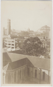
Photograph - Demolition of Advocate building and construction of Monastery, 1937
... Demolition of the Advocate begun 6 July 1937 and was completed by mid-August. ...Yellowing. Photograph Demolition of Advocate building and construction of Monastery ...A number of buildings were demolished along the south side of Little Lonsdale Street between St Francis Street and Elizabeth Street for the construction of the new Monastery for the Blessed Sacrament Congregation including a former school building and Advocate Press building. Demolition of the Advocate begun 6 July 1937 and was completed by mid-August. Construction works for the Monastery began soon after and was officially opened by Archbishop Mannix on 1 May 1938.Elevated view from south-west corner of St Francis Church, across roof top towards the partially demolished Advocate Press Building. In background, Coop's Shot Tower to the left, State Library to the right. Photographer unknown. Faded black and white photograph. Yellowing.church buildings, historic buildings, lost architecture, wrecking, melbourne, st francis' church -
 Congregation of the Blessed Sacrament and St. Francis’ Church, Heritage Centre
Photograph - Demolition of Advocate building and construction of Monastery, 1937
... Demolition of the Advocate begun 6 July 1937 and was completed by mid-August. ...Yellowing. Photograph Demolition of Advocate building and construction of Monastery ...A number of buildings were demolished along the south side of Little Lonsdale Street between St Francis Street and Elizabeth Street for the construction of the new Monastery for the Blessed Sacrament Congregation including a former school building and Advocate Press building. Demolition of the Advocate begun 6 July 1937 and was completed by mid-August. Construction works for the Monastery began soon after and was officially opened by Archbishop Mannix on 1 May 1938.Man pushing a wheelbarrow of rubble with the Advocate Press Building partially demolished in the background. Photographer unknown. Faded black and white photograph. Yellowing.church buildings, historic buildings, lost architecture, wrecking, melbourne, st francis' church -
 Congregation of the Blessed Sacrament and St. Francis’ Church, Heritage Centre
Photograph - Demolition of Advocate building and construction of Monastery, 1937
... Demolition of the Advocate begun 6 July 1937 and was completed by mid-August. ...Yellowing. Photograph Demolition of Advocate building and construction of Monastery ...A number of buildings were demolished along the south side of Little Lonsdale Street between St Francis Street and Elizabeth Street for the construction of the new Monastery for the Blessed Sacrament Congregation including a former school building and Advocate Press building. Demolition of the Advocate begun 6 July 1937 and was completed by mid-August. Construction works for the Monastery began soon after and was officially opened by Archbishop Mannix on 1 May 1938.Advocate Press Building being demolished by hand. Shows men on the upper storey, dismantling the building. Photographer unknown. Faded black and white photograph. Yellowing.church buildings, historic buildings, lost architecture, wrecking, melbourne, st francis' church -
 Eltham District Historical Society Inc
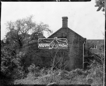
Photograph, Side view of Shillinglaw Cottage
... In the 1960s it was marked for demolition to make way for the construction of new council buildings but a community campaign saved the cottage and it was re-located....In the 1960s it was marked for demolition to make way for the construction of new council buildings but a community campaign saved the cottage and it was re-located. ...Side view of 'Shillllinglaw Cottage' in its original location on Main Road Eltham, 1964. The cottage was built by George Stebbings about 1859 and is made from hand made bricks laid in a Flemish bond pattern. In the 1960s it was marked for demolition to make way for the construction of new council buildings but a community campaign saved the cottage and it was re-located.Shillinglaw Cottage is itself historically, aesthetically and socially significant to the Shire of Nillumbik and is registered on the Victorian Heritage Database. This photo forms part of a collection of photographs gathered by the Shire of Eltham for their centenary project book, "Pioneers and Painters: 100 years of the Shire of Eltham" by Alan Marshall (1971). The collection of over 500 images is held in partnership between Eltham District Historical Society and Yarra Plenty Regional Library (Eltham Library) and is now formally known as 'The Shire of Eltham Pioneers Photograph Collection.' It is significant in being the first community sourced collection representing the places and people of the Shire's first one hundred years.Digital imagesepp, shire of eltham pioneers photograph collection, eltham, shillinglaw cottage -
 Melbourne Tram Museum
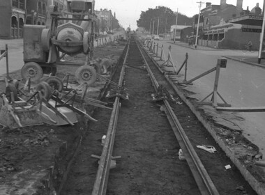
Negative - Tram track construction Nicholson St Fitzroy, Hugh Ballment, 1955
... The photograph shows the construction of tram track in Nicholson St Fitzroy, looking south. ...Melbourne Tram Museum 8 Wallen Road Hawthorn melbourne The photograph shows the construction of tram track in Nicholson St Fitzroy, looking south. ...The photograph shows the construction of tram track in Nicholson St Fitzroy, looking south. There are two rail clamps set up to enable the welding of the rail, a concrete mixer and work site protection barriers and lights. See item 8955 for a cable tram track demolition photo. Photo taken during 1955, the new line to East Brunswick was opened in April 1956.Yields information about the construction of the new line in Nicholson St Fitzroy.Negative - 127 film black and white.tramways, nicholson st, track work, track construction, new tramways -
 Bendigo Historical Society Inc.
Photograph - ALEC SANDNER COLLECTION: EUCALYPTUS FACTORY, ULEY STREET, NORTH BENDIGO
... View appears to show demolition rubble. ...Area looks to be a construction zone. 3777F View of Sandner's site. 3777G Sandner's Eucalyptus Distillery site. ...Seven photographs of the Sandner Eucalyptus Distillery/Factory, in Uley Street, North Bendigo. Photographs by Alex Sandner. Distillery began by Carl Sandner in 1875 and operated until 1967. Business records were donated to National Archives in Canberra. 3777A Sandner's Eucalyptus Distillery. 3777B Inside of a building. Building not used for its original purpose. 3777C Exterior view of one of the buildings. Note wooden door and large metal hinges to hang door. 3777D Exterior view of site of distillery. Construction vehicles noted on right of photograph. 3777E Distillery site. Area looks to be a construction zone. 3777F View of Sandner's site. 3777G Sandner's Eucalyptus Distillery site. View appears to show demolition rubble. Alec Sandnersandner's eucalyptus disillery, uley street -
City of Kingston
Photograph - Colour, 29 January 1993
... This 1993 image includes Bonbeach High School prior to demolition, Bonbeach Primary School and Patterson River Golf Club. ...This 1993 image includes Bonbeach High School prior to demolition, Bonbeach Primary School and Patterson River Golf Club. ...Bonbeach, Carrum and Patterson Lakes are suburbs in the City of Kingston. Bonbeach and Carrum were holiday destinations in early 20th century and over time the housing has converted to permanent residential structures. In Patterson Lakes, the area consists predominantly of newer housing developments and the tidal canal system which is accessible to many dwellings joins Port Phillip Bay.Bonbeach, Carrum and Patterson Lakes were previously part of the extensive Carrum Carrum Swamp. The area was once a source of fish and eels for the Mayone-Bulluk clan of the Bunurong people. Over time the area was drained and this allowed farming at Carrum and Bonbeach, although the area was prone to flooding. In the early 1920s and 30s the land was converted to residential dwellings. In 1973 investigations commenced nearby to Bonbeach and Carrum into the development of a unique residential area comprising canals and waterways. It was originally proposed to be known as "Gladesville". Circa 1974, the area was rezoned from rural to residential and named Patterson Lakes. Development has been continuous since the 1970s with staged construction of the waterways, residential housing, and supporting infrastructure and facilities.Laminated colour aerial photograph of the Bonbeach, Carrum and Patterson Lakes region within City of Kingston. This 1993 image includes Bonbeach High School prior to demolition, Bonbeach Primary School and Patterson River Golf Club. Sections of Patterson Lakes are not yet developed, including Rhode and Staten Islands. Long Island Point appears to be a recent development with many spare blocks and new houses under construction. The Patterson River marina is prominent and the river mouth as it meets Port Phillip Bay. The Carrum railway station is visible.Black type on white adhesive sticker: No. 6661 Black type on white adhesive sticker: 26E/6661, 29/1/93, 4.25 pm Black type on white adhesive sticker 29-1-93 Yellow circular adhesive stickerbonbeach, carrum, patterson lakes, patterson river, carrum carrum swamp, canals and waterways -
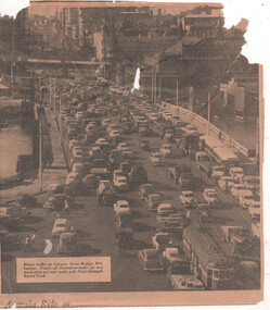 Melbourne Tram Museum
Newspaper - Spencer St bridge, traffic congestion and a hook turn, 1950s
... Photo shows extensive traffic congestion on the Spencer St bridge at the north end of Clarendon St South Melbourne, early 1950s, prior to the construction of the King St bridge. In the background is the Fish Market buildings prior to its demolition in 1958 - 1960 (see reference). ...Photo shows extensive traffic congestion on the Spencer St bridge at the north end of Clarendon St South Melbourne, early 1950s, prior to the construction of the King St bridge. In the background is the Fish Market buildings prior to its demolition in 1958 - 1960 (see reference). ...Photo shows extensive traffic congestion on the Spencer St bridge at the north end of Clarendon St South Melbourne, early 1950s, prior to the construction of the King St bridge. In the background is the Fish Market buildings prior to its demolition in 1958 - 1960 (see reference). The two lanes of traffic on the right side of the photo, or east side of the bridge, are queuing to do a hook turn into Lorimer St for Port Melbourne. This hook turn only operated during peak traffic hours and when a policeman was on duty.Yields information about traffic congestion on the Spencer St bridge in the early 1950s and a forgotten hook turn.Newspaper clipping from an unknown publication advertising Courtaulds Aust. Rayon tyres - A UK company who built a factory at Tomago NSW during 1951tramways, hook turns, south melbourne, spencer st bridge, traffic control, traffic congestion -
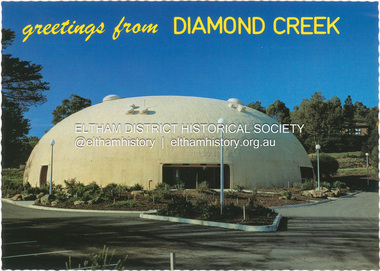 Eltham District Historical Society Inc
Postcard - Photograph, Nucolorvue Productions Pty Ltd, greetings from Diamond Creek, n.d
... The Shell was closed for safety reasons after a Bini Shell in another State had chunks of concrete fall off the dome due to a construction fault. At the Diamond Creek Town Fair in 1991 the demolition of the Bini Shell was an item on the Town Fair’s program. ...The Shell was closed for safety reasons after a Bini Shell in another State had chunks of concrete fall off the dome due to a construction fault. At the Diamond Creek Town Fair in 1991 the demolition of the Bini Shell was an item on the Town Fair’s program. ...Diamond Creek Bini Shell Community venue Built in 1979 in Diamond Creek opposite the hotel using a construction method invented by Dante Bini. A net of flexible steel rods were laid on the building’s circular base, on the top of a fabric bladder. Concrete was poured onto the mesh and a sealed cover laid over the concrete making a sandwich of cover, bladder and mesh. Compressed air was pumped into the bladder and the sandwich slowly began to rise and become a massive self-supporting dome. The inflation of the dome attracted crowds of onlookers many from various technical schools, VIPs and the famous football doctor, Donald Cordner. An opening night dinner was held to celebrate the construction and the Diamond Creek Bini Shell was used as a community venue for over ten years including for the Town Fair. The Shell was closed for safety reasons after a Bini Shell in another State had chunks of concrete fall off the dome due to a construction fault. At the Diamond Creek Town Fair in 1991 the demolition of the Bini Shell was an item on the Town Fair’s program. Information: Kevin Patterson, Nillumbik Historical Societybini shell, diamond creek community centre, nu-color-vue, postcard -
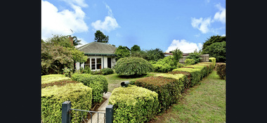 Eltham District Historical Society Inc
Photograph - Digital Photograph, Morrison Kleeman, 95 Bible Street, Eltham, February 2021
... The application was approved by VCAT on 2 February 2023. Construction commenced in 2025 with anticipated completion late 2025....Planning application 557/2021/03P was submitted 23 June 2021 for demolition of original free standing cottage and buildings and works to construct four (4) two-story townhouse dwellings and removal of vegetation. ...95 Bible Street, Eltham was a 1950s weatherboard cottage situated on the northwest corner of Dudley Street and Bible Street on a land size of approximately 695 square metres. It was listed for sale by Morrison Kleeman on 22 February 2021 and sold for $1,275,000 on 13 March 2021. Planning application 557/2021/03P was submitted 23 June 2021 for demolition of original free standing cottage and buildings and works to construct four (4) two-story townhouse dwellings and removal of vegetation. The application was refused by Nillumbik Shire Council on 4 April 2022 and the developer subsequently lodged an Appeal at VCAT on 11 May 2022. The application was approved by VCAT on 2 February 2023. Construction commenced in 2025 with anticipated completion late 2025.95 bible street, bible street, developer, dudley street, etham, properties, morrison kleeman estate agents -
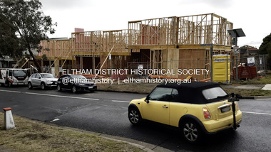 Eltham District Historical Society Inc
Photograph - Digital Photograph, Joan Castledine, 95 Bible Street, Eltham, 28 May 2025
... The application was approved by VCAT on 2 February 2023. Construction commenced in 2025 with anticipated completion late 2025....The application was approved by VCAT on 2 February 2023. Construction commenced in 2025 with anticipated completion late 2025. 95 Bible Street Bible Street Building Construction developer Dudley Street Etham Joan Castledine Collection Properties Born digital 95 Bible Street, Eltham Photograph Digital Photograph Joan Castledine ...95 Bible Street, Eltham was a 1950s weatherboard cottage situated on the northwest corner of Dudley Street and Bible Street on a land size of approximately 695 square metres. It was listed for sale by Morrison Kleeman on 22 February 2021 and sold for $1,275,000 on 13 March 2021. Planning application 557/2021/03P was submitted 23 June 2021 for demolition of original free standing cottage and buildings and works to construct four (4) two-story townhouse dwellings and removal of vegetation. The application was refused by Nillumbik Shire Council on 4 April 2022 and the developer subsequently lodged an Appeal at VCAT on 11 May 2022. The application was approved by VCAT on 2 February 2023. Construction commenced in 2025 with anticipated completion late 2025.95 bible street, bible street, building construction, developer, dudley street, etham, joan castledine collection, properties -
 Melton City Libraries
Photograph, Western Highway, 1983
... Construction of service road in front of the former Ann Dowling (Miers) 1866 Crown Grant, Title dated October 1870. ...Melton City Libraries 31 McKenzie Street Melton melbourne Construction of service road in front of the former Ann Dowling (Miers) 1866 Crown Grant, Title dated October 1870. ...Construction of service road in front of the former Ann Dowling (Miers) 1866 Crown Grant, Title dated October 1870. She married Henri Miers in 1867.Their house was located on the site near the Myers Gully part of Ryans Creek. Built in 1867 and later named “Burnbank” by Martha Myers after the Street in Ballarat were she lived before arriving in Melton in 1907. She married Frederick Myers in 1908. He died in 1963, and Martha moved to a new home at 5 McKenzie Street Melton in 1968. Attempts made by the family to retain the historic cottage were unsuccessful. A demolition order imposed by the Housing Commission and it was pulled down by the family. It was the home of the family and stood for over 100 years.East of Reserve Road towards Ferris Roadlandscapes of significance, misc. -
 Bendigo Historical Society Inc.
Document - National Trust Collection: Bendigo Home and Hospital for the Aged, 1860-1970s
... The central block has seen little external alteration since completion, except for a small glassed-in wind shield.The Porter's Lodge and Superintendent's Residence remain in good condition.Some ancillary buildings have been modified or are at risk of demolition due to new construction....The central block has seen little external alteration since completion, except for a small glassed-in wind shield.The Porter's Lodge and Superintendent's Residence remain in good condition.Some ancillary buildings have been modified or are at risk of demolition due to new construction. history National Trust Bendigo Collection bendigo Benevolant Home Bendigo benevolant asylum bendigo home and hospital for the aged bendigo ann caudle centre bendigo Typed History of the hospital, and letters regarding classification status and two A4 sized photos of the front of the building. ...The Bendigo Benevolent Home was founded in 1857, with the main building inaugurated on March 15, 1860. The original site was chosen to avoid mining areas and was granted by the government. Early temporary premises were used before the current site in Barnard Street was established. The original building was designed by architect Robert A. Love, with construction by contractor Crawford and Clerk of Works Rigley. The structure features a basement (kitchen, storage, cellars, staff apartments), a first floor (large dining room, additional rooms), and upper floors (dormitories). The building uses the arch principle and includes hot air heating, lavatories, and good ventilation. A significant memorial stone of Harcourt granite was laid in December 1872, forming part of the building's front elevation. Additions and modifications were made over time, including a west wing in 1868 to house 50 girls, and further expansions by architects Vahland & Getchmann. The central block has seen little external alteration since completion, except for a small glassed-in wind shield.The Porter's Lodge and Superintendent's Residence remain in good condition.Some ancillary buildings have been modified or are at risk of demolition due to new construction.Typed History of the hospital, and letters regarding classification status and two A4 sized photos of the front of the building. This item contains the following documents: 3084.52a Black and White Photo of the Bendigo Benevolent Asylum Front Entrance 3084.52b Another Black and White Photo of the Bendigo Benevolent Asylum Front Entrance 3084.52c National Trust of Australia (Victoria) survey and data sheet 3084.52d Letters regarding the classification by the National Trust (Contact BHS for details) 3084.52e Handwritten Notes on the History of the Home and Hospital for the Aged (Contact BHS for details)history, national trust bendigo collection, bendigo, benevolant home bendigo, benevolant asylum bendigo, home and hospital for the aged bendigo, ann caudle centre bendigo -
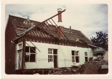
 Eltham District Historical Society Inc
Slide, Joh Ebeli, The old Baker's house prior to demolition, corner of York Street and Main Road, Eltham, c.Sep. 1979
... Photo taken immediately prior to the demolition of the old baker's shop on the corner of Main Road and York Street, Eltham. ...Eltham District Historical Society Inc 728 Main Rd Eltham melbourne Photo taken immediately prior to the demolition of the old baker's shop on the corner of Main Road and York Street, Eltham. ...Photo taken immediately prior to the demolition of the old baker's shop on the corner of Main Road and York Street, Eltham. Joh Ebeli and Elwers Howard endeavoured to preserve some parts of the house. The old weatherboard building, possibly dating from the 1860s, comprised a dwelling with a shop in the front room opening off a timber verandah deck which directly fronted the Main Road footpath. At the rear is a brick building of much later date which was for many years used for the bakery. The buildings were demolished for flat construction. Publicity at the time was oriented toward moves to preserve the weatherboard building which came from a number of individuals including members of this society. The society had no official connection with any proposal to retain the building or any part of it on any other site. The issues involved were part of a wider consideration of the matter of preservation of historic buildings. In this case the Society and in particular the committee had been aware for some years of the impending demolition. The possibility of the preservation of the building had been canvassed on a number of occasions. The Society’s view was that whilst the baker’s shop was an interesting old building which contributed to the character of Main Road, it was not of sufficient importance to wage an organised campaign for its preservation. It considered that if the building were to be preserved for historical reasons it would be far more feasible to retain it in its present location than to re-build it on another site.35 mm colour positive transparency Mount - Agfachrome Professional black (Germany) 4 dotsmain road, old eltham bakery, york street -
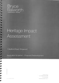 Ringwood and District Historical Society
Book, Bryce Raworth, Heritage Impact Assessment - 1 Bedford Road, Ringwood, Victoria. Application for permit - Proposed Redevelopment - July 2021, 2021
... CONCLUSION: The proposed demolition of the former Blood Brothers Store at 1 Bedford Street (sic), Ringwood and the construction of a multi-storey car park on the enlarged site will result in the loss of some significance to the Heritage Overlay. ...CONCLUSION: The proposed demolition of the former Blood Brothers Store at 1 Bedford Street (sic), Ringwood and the construction of a multi-storey car park on the enlarged site will result in the loss of some significance to the Heritage Overlay. ...A4 size wire-bound book compiled by Bryce RaworthINTRODUCTION: This heritage impact assessment (HIS) was prepared at the request of the City of Maroondah, the owner of the subject property at 1 Bedford Street (sic), Ringwood. It relates to a proposal to demolish the existing shop on the site and construct a multi-storey car park incorporating a commercial tenancy at the lower levels. It reviews the significance of the existing building on the site and the contribution it makes to the surrounding streetscapes, then comments on the heritage impacts of the proposed demolition in the context of the significance of the place and broader considerations. This office has previously provided an Historical Overview of the subject site (June 2020) and this assessment draws upon that previous research and analysis. The report has been prepared by Guy Murphy and Bryce Raworth. CONCLUSION: The proposed demolition of the former Blood Brothers Store at 1 Bedford Street (sic), Ringwood and the construction of a multi-storey car park on the enlarged site will result in the loss of some significance to the Heritage Overlay. The degree of loss is moderated by the partial intactness of the store, its modest character and the loss of its original setting, as well the proposal to implement a heritage interpretation strategy for the site. When considered in the context of the broader range of urban planning considerations and broader net community benefit, the proposed development is supported with respect to heritage impacts. -
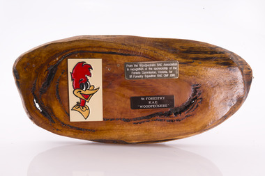 Department of Energy, Environment and Climate Action
Presentation plaque from the "Woodpeckers"
... Several other Victorian departments such as the State Electricity Commission (SEC) did the same thing who supported a construction squadron based at Newborough in the Latrobe Valley. ...Several other Victorian departments such as the State Electricity Commission (SEC) did the same thing who supported a construction squadron based at Newborough in the Latrobe Valley. ...In the post-war era from 1947 to the mid-1980s, the Forests Commission sponsored Australia's only military sawmilling unit, the 91 Forestry Squadron. It was a special reserve unit of the Royal Australian Engineers (RAE). Established and commanded by Commission forester and WW2 veteran, Major Ben Benallack, the "Woodpeckers" as they were known comprised a small pool of specialised soldiers capable of rapid mobilisation in the event of need. Several other Victorian departments such as the State Electricity Commission (SEC) did the same thing who supported a construction squadron based at Newborough in the Latrobe Valley. The scheme created a very active and capable part-time military group that completed many worthy projects across the State. In addition to their military training, the Woodpeckers operated bush sawmills, built timber bridges along the Murray River, the Snake Island Jetty, forest roads and performed various demolition tasks. Presentation plaque from the "Woodpeckers" Mounted on polished wooden burl The timber burl was cut from a Eucalyptus obliqua (Messmate) salvaged in Wonga Wonga after the 1983 Ash Wednesday fires.From the Woodpeckers RAE Association in recognition of the sponsorship of the Forests Commission, Victoria, for 91 Forestry Squadron RAE CMF (SR)forests commission victoria (fcv)