Showing 87 items matching "country lands"
-
 Bendigo Historical Society Inc.
Map - COUNTRY LANDS, 4/06/1874
... COUNTRY LANDS......country lands...Map: Country lands, Parishes of Goornong, Egerton, Elmore and Nolan, County of Bendigo. ...History House 11 Mackenzie Street Bendigo goldfields MAP Bendigo country lands Country lands Goornong Elmore Egerton Nolan Map: Country lands, Parishes of Goornong, Egerton, Elmore and Nolan, County of Bendigo. ...Map: Country lands, Parishes of Goornong, Egerton, Elmore and Nolan, County of Bendigo. Parish plan (number 298 in map cupboard 1)map, bendigo, country lands, country lands, goornong, elmore, egerton, nolan -
Stawell Historical Society Inc
Map, Country Lands Parishes of Drung Drung & Golton Golton, 1866
... Country Lands Parishes of Drung Drung & Golton Golton ...Country Lands Parishes of Drung Drung & Golton Golton ...Stawell Historical Society Inc 46 Longfield St Stawell grampians Stawell Country Lands Parishes of Drung Drung & Golton Golton Country Lands Parishes of Drung Drung & Golton Golton Map ...Country Lands Parishes of Drung Drung & Golton Golton stawell -
 Ringwood and District Historical Society
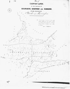
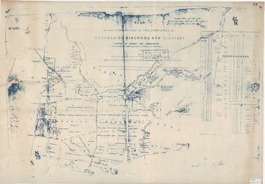
Map, Plan of Country Lands, in the Parishes of Nunawading, Ringwood and Scoresby. c1870
... Plan of Country Lands, in the Parishes of Nunawading, Ringwood and Scoresby. c1870....Written on front of map: " Plan of Country Lands, in the Parishes of Nunawading, Ringwood and Scoresby, in the Counties of Bourke and Mornington."...Written on front of map: " Plan of Country Lands, in the Parishes of Nunawading, Ringwood and Scoresby, in the Counties of Bourke and Mornington." ...Black and white copy of mapWritten on front of map: " Plan of Country Lands, in the Parishes of Nunawading, Ringwood and Scoresby, in the Counties of Bourke and Mornington." -
 Ballan Shire Historical Society
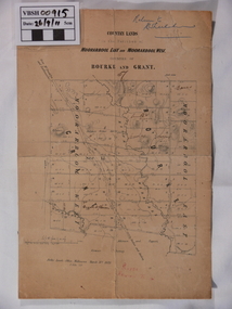
Map - Map. Moorarbool East and West, Country Lands in the Parishes of Moorarbool East and Moorarbool West. Counties of Bourke and Grant
... Country Lands in the Parishes of Moorarbool East and Moorarbool West. ...This is a map of "Country Lands" around the Werribee River, north of Ballan in the Counties of Bourke and Grant....The map is dated March 31st, 1859. Country Lands in the Parishes of Moorarbool East and Moorarbool West. ...This is a map of "Country Lands" around the Werribee River, north of Ballan in the Counties of Bourke and Grant.A relatively small map, paper on a material backing. Shows topographical features, roads and property divisions. Scale of forty chains to one inch. The map is dated March 31st, 1859.There is a small inscription under the chain scale that reads "No 58/364 John Phillips ? Survey 1st August 1858". The name Dugald McPherson is hand written on one of the blocks of land.moorarbool west, moorarbool east, dugald mcpherson, county of bourke, county of grant, werribee river, ballan -
Bendigo Historical Society Inc.
Map - CALAVIL, 28/08/1874
... ...country lands...Map: Country Lands, Parish of Calavil, County of Bendigo. ...History House 11 Mackenzie Street Bendigo goldfields MAP Bendigo country lands Country lands Parish of Calavil Map: Country Lands, Parish of Calavil, County of Bendigo. ...Map: Country Lands, Parish of Calavil, County of Bendigo. Parish plan (number 334 in map cupboard 1)map, bendigo, country lands, country lands, parish of calavil -
 Ringwood and District Historical Society
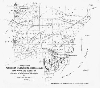
Map - Plan of Survey, Country Lands, Parishes of Warrandyte, Mooroolbark, Ringwood and Scoresby, Counties of Evelyn and Mornington - circa 1855
... Country Lands, Parishes of Warrandyte, Mooroolbark, Ringwood and Scoresby, Counties of Evelyn and Mornington - circa 1855....Clipped section of larger survey map including descriptions of treed areas and topographical features. Country Lands, Parishes of Warrandyte, Mooroolbark, Ringwood and Scoresby, Counties of Evelyn and Mornington - circa 1855. ...Clipped section of larger survey map including descriptions of treed areas and topographical features. Surveyed by (signature of J. Hardy) - Assistant Surveyor. -
 Ringwood and District Historical Society
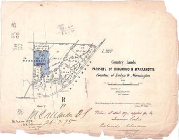
Map, Country Lands, Parishes of Ringwood & Warrandyte, Counties of Evelyn and Mornington - 1868
... Country Lands, Parishes of Ringwood & Warrandyte, Counties of Evelyn and Mornington - 1868....Blue shaded area marked on Department of Lands & Survey map highlighting portion of allotment 27B applied for by James Forbes. Torn edges. Country Lands, Parishes of Ringwood & Warrandyte, Counties of Evelyn and Mornington - 1868. ...Blue shaded area marked on Department of Lands & Survey map highlighting portion of allotment 27B applied for by James Forbes. Torn edges.L3922. Photo-lighographed at DL&S, Melbourne by J. Noone, June 8th, 1868. Signature of Assistant Surveyor M. Callanan dated 26.7.1875. Noted on R72 by H. Robinson, 1.10.1875. -
 Ringwood and District Historical Society
Map, Plan of Country Lands in the Parishes of Nunawading Ringwood and Scoresby - circa 1855
... Plan of Country Lands in the Parishes of Nunawading Ringwood and Scoresby - circa 1855...Descriptive remarks include areas marked "Farmer's Common", "Poor soil thickly/moderately timbered with stringy bark", and location of water and firewood reserves. Plan of Country Lands in the Parishes of Nunawading Ringwood and Scoresby - circa 1855 Map ...Blueprint copy of Survey Map detailing original Selectors' names and property locations. List of Parish map references including property bearings, distances in Links, and markings on trees. Descriptive remarks include areas marked "Farmer's Common", "Poor soil thickly/moderately timbered with stringy bark", and location of water and firewood reserves."Surveyed and plotted by N.M. Bickford, Superintendant of Mr. Hodgkinson's Field Party". "The land comprised in this survey is of inferior quality, moderately undulating, and thickly wooded. It is watered by Dandenong Creek and Deep Creek." Inset map showing location of (*proposed) cemetery on southern corner of Lillydale Road from Melbourne and Sawmill Road, later Mount Dandenong Road. (*Cemetery did not eventuate.) -
Bendigo Historical Society Inc.
Map - CAMPBELL COLLECTION: BENDIGO AND DISTRICT MAPS
... ...country lands...History House 11 Mackenzie Street Bendigo goldfields MAP Bendigo country lands Map. Ascot Unit, scale 20 chains to an inch, arrow pointing to magnetic north, road to Fosterville to the East, Huntly 3/4 mile to the West, road to Epsom 3/4 mile and road to Bendigo 4 1/2 miles south west on map, also on page is the Northern Railway (Bendigo to Echuca) line. ...Map. Ascot Unit, scale 20 chains to an inch, arrow pointing to magnetic north, road to Fosterville to the East, Huntly 3/4 mile to the West, road to Epsom 3/4 mile and road to Bendigo 4 1/2 miles south west on map, also on page is the Northern Railway (Bendigo to Echuca) line. (number 355 in map cupboard 1)map, bendigo, country lands -
Bendigo Historical Society Inc.
Map - CAMPBELL COLLECTION: BENDIGO & DISTRICT MAPS, 2-2-29
... ...country lands...History House 11 Mackenzie Street Bendigo goldfields MAP Bendigo country lands W.J.Galbraith Map. Wellsford, Parishes of Wellsford and Axedale. ...Map. Wellsford, Parishes of Wellsford and Axedale. Scale 20 chains to 1 inch. Total area 4994 acres. Prepared in W.P.B. from A. and P. Plans by W.J.G. (number 377 in map cupboard 1)W.J.Galbraithmap, bendigo, country lands -
Bendigo Historical Society Inc.
Map - CAMPBELL COLLECTION: BENDIGO & DISTRICT MAPS
... ...country lands...History House 11 Mackenzie Street Bendigo goldfields MAP Bendigo country lands Map. copy. Raywood, Neilborough, Sebastian, Yarraberb, Woodvale. ...Map. copy. Raywood, Neilborough, Sebastian, Yarraberb, Woodvale. (number 372 in map cupboard 1)map, bendigo, country lands -
Bendigo Historical Society Inc.
Map - CAMPBELL COLLECTION: BENDIGO & DISTRICT MAPS
... ...country lands...History House 11 Mackenzie Street Bendigo goldfields MAP Bendigo country lands Map. Bendigo Whipstick, Scale 40 chains to 1 inch, Forests Commission Victoria, map N0.3, legend for roads and land and forest. ...Map. Bendigo Whipstick, Scale 40 chains to 1 inch, Forests Commission Victoria, map N0.3, legend for roads and land and forest. (number 371 in map cupboard 1)map, bendigo, country lands -
 Bendigo Historical Society Inc.
Map - PLAN GENERAL SURVEY MALMSBURY PORCUPINE INN, FOREST CREEK TO GOLDEN POINT. ALEXANDRA RANGE 1853
... ...country lands...History House 11 Mackenzie Street Bendigo goldfields MAP Bendigo country lands R. Hoddle Colour Copy of Plan of the General Survey from the Town of Malmsbury to the Porcupine Inn, from the sources of Forest Creek to Golden Point, shewing (sic) the Alexandrian Range also Sawpit Gully Bendigo and Bullock Creeks. ...Colour Copy of Plan of the General Survey from the Town of Malmsbury to the Porcupine Inn, from the sources of Forest Creek to Golden Point, shewing (sic) the Alexandrian Range also Sawpit Gully Bendigo and Bullock Creeks. Handwritten note under the title a follows '' Forwarded to the Colonial Secretary with my letter No A 53/105 dated 30th March 1853 for transmission to the Geological Surveyor. R Hoddle Surveyor General. ' Stamped by Department of Mines Victoria with record#123 in Top right Hand corner. Also contains a catalogue number 2053/M/2. Part of the Contents of a DVD entitled 'Mapping Great Change' - Archival Maps, produced to support an exhibition in the Post Office Gallery Bendigo. A description of the Map, its history and implications for both historical and future discussions is contained in an Essay 'Mapping Great Changes' : The landscape of central Victoria by Gerry Gill.R. Hoddlemap, bendigo, country lands -
Bendigo Historical Society Inc.
Map - CAMPBELL COLLECTION: BENDIGO AND DISTRICT MAPS
... ...country lands...History House 11 Mackenzie Street Bendigo goldfields MAP Bendigo country lands Map. Bendigo Whipstick Forest Park, 1:75,000, reserved forest and crown land, highway main road access forest tracks. ...Map. Bendigo Whipstick Forest Park, 1:75,000, reserved forest and crown land, highway main road access forest tracks. New Moon Mine, Elliot Dam, Nuggety Dam, Rogers Tree, Old Tom Mine, Blow Holes, Skylark Dam, Monument Rock, Hartland Eucalyptus Still and Dam, Hartland Eucalyptus Farm, Millwood Dam, Sandner Eucalyptus Still Site, Various unmarked dams. (number 391 in map cupboard 1)map, bendigo, country lands -
Bendigo Historical Society Inc.
Map - CAMPBELL COLLECTION: BENDIGO AND DISTRICT MAPS
... ...country lands...History House 11 Mackenzie Street Bendigo goldfields MAP Bendigo country lands Map. Lyell, Parishes of Sedgwick, Eppalock and Lyell. ...Map. Lyell, Parishes of Sedgwick, Eppalock and Lyell. Scale 20 chains to 1 inch. Total area 3307 acres. (number 387 in map cupboard 1)map, bendigo, country lands -
 Ringwood and District Historical Society
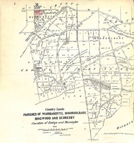
Map, Map showing Parishes of Warrandyte, Mooroolbark, Ringwood and Scoresby. 1870
... Written on front of map: "Country Lands. Parishes of Warrandyte, Mooroolbark, Ringwood and Scoresby. ...Written on front of map: "Country Lands. Parishes of Warrandyte, Mooroolbark, Ringwood and Scoresby. ...Black and white copy of mapWritten on front of map: "Country Lands. Parishes of Warrandyte, Mooroolbark, Ringwood and Scoresby. Counties of Evelyn an Mornington." -
Whitehorse Historical Society Inc.
Map, Nunawading, Ringwood and Scoresby, 16/02/1858 (original)
... Plan of country lands in the Parishes of Nunawading, Ringwood and Scoresby in the Counties of Bourke and Mornington. ...Whitehorse Historical Society Inc. 2-10 Deep Creek Road Mitcham melbourne nunawading ringwood scoresby maps Plan of country lands in the Parishes of Nunawading, Ringwood and Scoresby in the Counties of Bourke and Mornington. ...Plan of country lands in the Parishes of Nunawading, Ringwood and Scoresby in the Counties of Bourke and Mornington. Lithographed at the Public Lands Office, Melbourne, 16 February 1858. Inset: Pound Reserve, Nunawading.nunawading, ringwood, scoresby, maps -
 Whitehorse Historical Society Inc.
Document - Report, Nunawading land, 01/10/1855
... Headed: 'Final Report of a sale by public auction of suburban and country lands held at Melbourne on the 22nd October 1855'....Headed: 'Final Report of a sale by public auction of suburban and country lands held at Melbourne on the 22nd October 1855'. ...Photocopies of 3 sheets of documents in the Public Record Office listing the first land purchases in Nunawading. Headed: 'Final Report of a sale by public auction of suburban and country lands held at Melbourne on the 22nd October 1855'.williams, william, cousens, james, heading, nalborough, phillip, riley, patrick, blood, thomas, cook, holland, john, lobb, burrell, charles, land subdivision -
 Bendigo Historical Society Inc.
Document - RAILWAYS COLLECTION: CROWN LANDS SURVEYED IN DISTRICT OF SANDHURST
... RAILWAYS COLLECTION -large cream -coloured paper photocopy of 'Crown Lands Surveyed in District of Sandhurst' x 2 Information has been entered into columns showing Parish, Town Lands, Suburban Lands, Country Lands, Total Lands Surveyed, Date of Survey, Date of Sale, most Dates of Sale are 1854 The documents have been cancelled....DOCUMENT Crown Land Survey RAILWAYS COLLECTION -large cream -coloured paper photocopy of 'Crown Lands Surveyed in District of Sandhurst' x 2 Information has been entered into columns showing Parish, Town Lands, Suburban Lands, Country Lands, Total Lands Surveyed, Date of Survey, Date of Sale, most Dates of Sale are 1854 The documents have been cancelled. ...RAILWAYS COLLECTION -large cream -coloured paper photocopy of 'Crown Lands Surveyed in District of Sandhurst' x 2 Information has been entered into columns showing Parish, Town Lands, Suburban Lands, Country Lands, Total Lands Surveyed, Date of Survey, Date of Sale, most Dates of Sale are 1854 The documents have been cancelled.document, crown land survey -
 Bendigo Historical Society Inc.
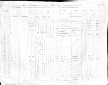
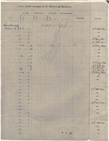
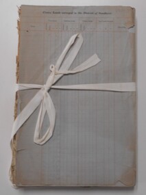
Document - LANDS OFFICE - CROWN LANDS SURVEYED AND SOLD - INDEX, 26.1.1857 - 1871
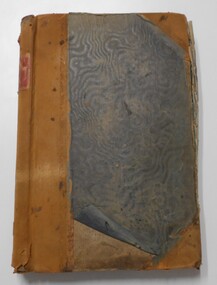
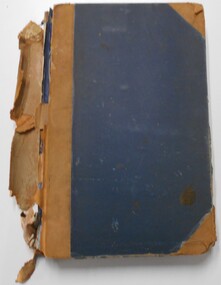
... Document: hard cover journal, faded dark green cover with brown corners and spine. 193 pages filled out - LH page: Parish, town lands, suburban lands, country lands, total lands surveyed, date of survey RH page: date of sale, by auction, by selection, price per acre, total amount, name of purchaser. ...Lands Office Document: hard cover journal, faded dark green cover with brown corners and spine. 193 pages filled out - LH page: Parish, town lands, suburban lands, country lands, total lands surveyed, date of survey RH page: date of sale, by auction, by selection, price per acre, total amount, name of purchaser. ...Document: hard cover journal, faded dark green cover with brown corners and spine. 193 pages filled out - LH page: Parish, town lands, suburban lands, country lands, total lands surveyed, date of survey RH page: date of sale, by auction, by selection, price per acre, total amount, name of purchaser. On spine ' 01, index book O'.Lands Officelands office, bendigo, sandhurst, crown lands sold, rural land. -
 Bendigo Historical Society Inc.
Document - LANDS OFFICE : SPECIAL LAND SALES IN SANDHURST 1861 TO 1864, 1861 - 1864
... LH page: parish, town lands, suburban lands, country lands, total lands surveyed, date of survey. ...LH page: parish, town lands, suburban lands, country lands, total lands surveyed, date of survey. ...Document: light brown cover, hard cover journal. Contains details of crown lands surveyed and sold in the District of Sandhurst. Index and 217 pages. LH page: parish, town lands, suburban lands, country lands, total lands surveyed, date of survey. RH page: date of sale, by auction, by selection, price per acre, total amount, names of purchasers. On spine: '2' in red, ' sales Bendigo 1861 - 1864'Lands Officeplace, bendigo, land sales, bendigo, sandhurst, land sales, land surveyed -
 Bendigo Historical Society Inc.
Document - LANDS OFFICE, CROWN LANDS SURVEYED AND SOLD, 1860/70
... LH page ' town lands, suburban lands, country lands, total lands surveyed, date of survey. ...LH page ' town lands, suburban lands, country lands, total lands surveyed, date of survey. ...Document: buff hard cover journal, embossed on borders. On spine 'Lands and Survey' 'Index Book' and '03'. Contains list of parishes in front cover, indexed to page numbers which describes land surveyed and sold in parishes. Double page entries. 230 pages in book. LH page ' town lands, suburban lands, country lands, total lands surveyed, date of survey. RH page: date of sale, by auction, by selection, price per acre, total amount name of purchaser.Lands Officeland sales, lands office, land surveyed, land sold, bendigo, sandhurst -
 Bendigo Historical Society Inc.
Document - LANDS OFFICE, CROWN LANDS SURVEYED AND SOLD SANDHURST DISTRICT, 1854 (?) onwards
... On LH page, town, suburban or country lands. RH page: auction, selection, price per acre, price and purchaser. ...On LH page, town, suburban or country lands. RH page: auction, selection, price per acre, price and purchaser. ...Document: buff colour hard cover journal. Contains details of crown lands surveyed and sold. On LH page, town, suburban or country lands. RH page: auction, selection, price per acre, price and purchaser. Indexed by parish in front page. Two front pages cut out. On spine ' Index book' ' Lands and Survey' '06' 'E' ' Country' and 'Sales'Lands Officeplace, land sales, bendigo, lands office, land surveyed, land sold, sandhurst -
 Bendigo Historical Society Inc.
Book - CROWN LAND SALES: RECORDS OF SALE 1860 - 1865
... On top of RH page: Crown Lands sold in the District of Sandhurst' Entries contain details of town lands, suburban lands, country lands, total lands surveyed and date of survey. ...On top of RH page: Crown Lands sold in the District of Sandhurst' Entries contain details of town lands, suburban lands, country lands, total lands surveyed and date of survey. ...Land sale journal, blue lined pages, no cover. On top of LH page: Crown Land surveyed in the District of Sandhurst. On top of RH page: Crown Lands sold in the District of Sandhurst' Entries contain details of town lands, suburban lands, country lands, total lands surveyed and date of survey. Date of sale, by auction, by selection and total amount paid. Names of purchasers listed. Entries date from 1860 - 1865. Written across all pages in blue pencil 'Cancelled' and a date for each cancellation: Wm. Rundell 8.9.80.bendigo, land sales, sandhurst -
 Bendigo Historical Society Inc.
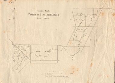
Document - MARKS COLLECTION: MAP OF PARISH OF STRATHFIELDSAYE 1858, 8th September, 1858
... Buff coloured document. On top 'Country Lands, Parish of Strathfieldsaye, County Unnamed'. ...History House 11 Mackenzie Street Bendigo goldfields MAP Bendigo parish of strathfieldsaye 1858 Buff coloured document. On top 'Country Lands, Parish of Strathfieldsaye, County Unnamed'. ...Buff coloured document. On top 'Country Lands, Parish of Strathfieldsaye, County Unnamed'. On bottom 'Scale 40 chains to an inch. Public Lands Office, Melbourne Sept 8th. 1858. William Collis, Lith ( lithographer )'. Map shows Village Reserve on Emu Creek, road from Sandhurst, Sheepwash Creek and Splitters Creek. Wellington Hotel marked on map near intersection of Sheepwash Creek, Axe Creek and Emu Creek. Axe Creek Pound near Splitters Creek.map, bendigo, parish of strathfieldsaye 1858 -
 Bendigo Historical Society Inc.
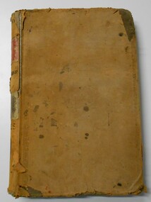
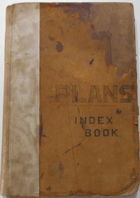
Document - LANDS OFFICE, - INDEX TO CROWN LANDS SURVEYED AND SOLD IN THE DISTRICT OF SANDHURST
... Double page entries: LH side page: town, suburban or country lands, total lands surveyed. Date of survey. ...Double page entries: LH side page: town, suburban or country lands, total lands surveyed. Date of survey. ...Document: Buff hard cover book, with fawn coloured binding on spine (later addition to mend spine?) On front cover drawn in black pen ' PLANS' and 'Index Book' On spine written in black ink ' plans index book'. Contains index of parishes in front of journal with 470 pages indexed to parishes. Double page entries: LH side page: town, suburban or country lands, total lands surveyed. Date of survey. RH page: allotment, section, particulars, no. page. Entries are not dated.Lands Officeland sales, lands office, land surveyed , land sold, bendigo, sandhurst -
 Bendigo Historical Society Inc.
Document - LANDS OFFICE, CROWN LOTS SURVEYED AND SOLD IN THE SANDHURST DISTRICT 1857 - 1905, 1857 - 1914
... LH page: town, suburban or country lands. RH page: auction, selection, price per acre, price overall and purchaser. ...LH page: town, suburban or country lands. RH page: auction, selection, price per acre, price overall and purchaser. ...Document: blue hard cover journal with buff spine and corners. (spine in poor condition, frayed and pieces missing) Contains details of crown lands surveyed and sold in Sandhurst district. LH page: town, suburban or country lands. RH page: auction, selection, price per acre, price overall and purchaser. Indexed by parish inside front cover. On spine ' Index book' ' Lands and Survey' '07' written on spine under damaged spine cover. Dated from 26/6/1857 to 24 February 1914Lands Officeland sales, lands office, land surveyed, land sold, bendigo, sandhurst -
 Kiewa Valley Historical Society
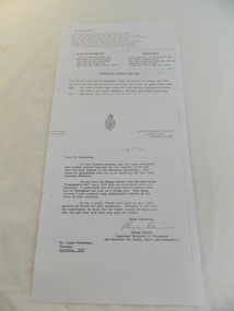
Papers - Edmondson's Hut, The letter is dated 8th October 1974
... country Edmondson's Hut is a cattleman's hut on the Bogong High Plains. Jim Edmondson obtained Run 33 (near Mt Nelse) in the early 1930s. He pre cut the timber at his property in Tawonga and along with iron for the walls, chimney and roof took it up to the Bogong High Plains on pack horse. The hut's wall and ceiling were lined and the hut had a 'fairly good floor and bunks'. In 1971 the hut was donated to the Education Department and was approved for transfer by the Lands ...Edmondson's Hut is a cattleman's hut on the Bogong High Plains. Jim Edmondson obtained Run 33 (near Mt Nelse) in the early 1930s. He pre cut the timber at his property in Tawonga and along with iron for the walls, chimney and roof took it up to the Bogong High Plains on pack horse. The hut's wall and ceiling were lined and the hut had a 'fairly good floor and bunks'. In 1971 the hut was donated to the Education Department and was approved for transfer by the Lands Department in 1974. Bogong Outdoor School camp has been using the hut for students to camp in as well as National Fitness parties when walking in the area. The upper Kiewa Valley was settled from the mid 1860s and from its earliest days cattle were taken on to the Bogong High Plains to graze during summer. Jim Edmondson took his cattle from the Kiewa Valley to Mt Fainter and later to Run 33, near Mt Nelse. His hut is significant in the history of Cattlemen's huts on the Bogong High Plains.Four A4 typed sheets on white paper - 1. Acknowledgement of transfer of Edmondson's Hut. 2. History of Visitors (to the hut) Prior to 1971. 3. Two poems. 4. One poem 1. Emblem of Education Dept. Centre top of page. Addressed to James Edmondson, Tawonga, Victoria. 2. Page headed History and Visitors prior 1971. 3. My Old black Poley Cow (and) Roper's Track. 4. So Long, Mates!education department. edmondson's hut. bogong high plains. cattlemen. poetry. cattleman hut. bush walking. -
 Kiewa Valley Historical Society
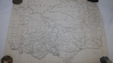
Maps of Victoria
... Lands & Survey 1876'. 2. Map of the Ovens & Murray District, Victoria with handwritten 'F.H. Hiscock & Co's, New Victoria Countries Atlas 1874'. 3. ...Kiewa Valley Historical Society Mount Beauty Information Centre 31 Bogong High Plains Rd Mt Beauty high-country maps of victoria 19th century oven and murray district of victoria Three maps: copies from the 19th century. 1. Handwritten 'Dept of Lands ...Three maps: copies from the 19th century. 1. Handwritten 'Dept of Lands & Survey 1876'. 2. Map of the Ovens & Murray District, Victoria with handwritten 'F.H. Hiscock & Co's, New Victoria Countries Atlas 1874'. 3. Map of the Murray and Gipps Land Distr' with handwritten: "Baillieu's County Atlas of Victoria 1866'.maps of victoria, 19th century, oven and murray district of victoria -
 Kiewa Valley Historical Society
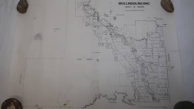
Map - Mullindolingong
... Kiewa Valley Historical Society Mount Beauty Information Centre 31 Bogong High Plains Rd Mt Beauty high-country Land owners of land in the Kiewa Valley in 1928 The Kiewa Valley was farming country with families settling in the area prior to 1928 mullindolingong kiewa valley land owners families of the kiewa valley Two sheets the same: (one old with paper joined together and the other is a copy without any joins. 21 6 1928 dated Map of Mullindolingong / County of Bogong showing land owners along the Kiewa River and beyond.Produced by the Department of Lands and Survey, Melbourne Map - Mullindolingong ...Land owners of land in the Kiewa Valley in 1928The Kiewa Valley was farming country with families settling in the area prior to 1928 Two sheets the same: (one old with paper joined together and the other is a copy without any joins. 21 6 1928 dated Map of Mullindolingong / County of Bogong showing land owners along the Kiewa River and beyond.Produced by the Department of Lands and Survey, Melbournemullindolingong, kiewa valley, land owners, families of the kiewa valley