Showing 107 items matching "county of mornington"
-
 MYLI My Community Library
Map - Nar Nar Goon County of Mornington Map, 1944, H.E Daw - Government Printer, June 1944
... Nar Nar Goon County of Mornington Map, 1944......County of Mornington.... / This plan has been compiled from the Lands Department Record as at June 1944 / Nar-Nar-Goon / County of Mornington / Drawn and reproduced at the department of lands and survey, Melbourne Price 2/. ...Daw Map Nar-Nar-Goon County of Mornington Pakenham Koo-Wee-Rup On Left Side: Pakenham (lot numbers throughout the map) Top side: Gembrook, Tonimbuk Right Side: Bunyip, Koo-wee-rup East Bottom Side: By Authority: / H.E. ...This was a map made in the period before Cardinia shire was created in 1994. With intricate labelling of lot allocations, this map is a invaluable research potential for understanding the settlement of the area and its development in the first half of the 1900s. A paper map with yellow shaded areas and black ink.On Left Side: Pakenham (lot numbers throughout the map) Top side: Gembrook, Tonimbuk Right Side: Bunyip, Koo-wee-rup East Bottom Side: By Authority: / H.E. Daw Government Printer / Melbourne Koo-wee-rup Bottom Right Corner: NOTE: The allotments colored brown are freehold. In respect of which the name. The Area, and the Date where given, are the particulars set out in the Crown grant as issued by the Lands Department. / After the issue of the Crown Grant, all subsequent dealings are effected at the office of titles, Queen Street, Melbourne, and particulars as to present registered ownership, boundaries, subdivisions, etc., may be obtained by search at that office. / This plan has been compiled from the Lands Department Record as at June 1944 / Nar-Nar-Goon / County of Mornington / Drawn and reproduced at the department of lands and survey, Melbourne Price 2/. June 1944 h.e. daw, map, nar-nar-goon, county of mornington, pakenham, koo-wee-rup -
 Emerald Museum & Nobelius Heritage Park
Map - Municipality Road Classification - Beaconsfield-Emerald Rd., Shire of Gembrook 1973, Title Survey Division, Crown Description - Part of Crown Allotment 44, Parish of Gembrook, County of Mornington, c1973
... Title Survey Division, Crown Description - Part of Crown Allotment 44, Parish of Gembrook, County of Mornington...Image of Crown Survey Map for crown allotment 44 (Beaconsfield-Emerald Rd.) parish of Gembrook, County of Mornington...Title Survey Division/Crown Description/Part of Crown Allotment 44, Parish of Gembrook, County of Mornington/Municipality Road Classification, Shire of Berwick, Beaconsfeld-Emerald Rd. ...(MR)/Francis J Webber of Kirkpatrick & Webber, 285 Maroondah Hwy., Ringwood/(Signed) - Principal Title Survey Office 16.1.73/SP13461 Image of Crown Survey Map for crown allotment 44 (Beaconsfield-Emerald Rd.) parish of Gembrook, County of Mornington Title Survey Division, Crown Description - Part of Crown Allotment 44, Parish of Gembrook, County of Mornington Map Municipality Road Classification - Beaconsfield-Emerald Rd., Shire of Gembrook 1973 ...Image of Crown Survey Map for crown allotment 44 (Beaconsfield-Emerald Rd.) parish of Gembrook, County of MorningtonTitle Survey Division/Crown Description/Part of Crown Allotment 44, Parish of Gembrook, County of Mornington/Municipality Road Classification, Shire of Berwick, Beaconsfeld-Emerald Rd. (MR)/Francis J Webber of Kirkpatrick & Webber, 285 Maroondah Hwy., Ringwood/(Signed) - Principal Title Survey Office 16.1.73/SP13461 -
 Ringwood and District Historical Society
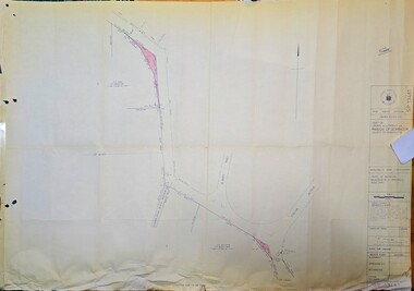
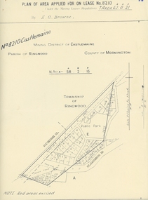
Map, Department of Mines, Plan of area applied for under the mining leases regulations in the township of Ringwood between Maroondah Highway and Mt. Dandenong Road. Mining District of Castlemaine, County of Mornington, Parish of Ringwood T Area 58(A) 2 (R)15(P) Acres, Roods, Perches. 1934, 20-Feb-34
... Mining District of Castlemaine, County of Mornington, Parish of Ringwood T Area 58(A) 2 (R)15(P) Acres, Roods, Perches. 1934...Dandenong Road. the area applied for on lease No.8210 by E.G.Browne.Mining District of Castlemaine, County of Mornington, Parish of Ringwood T Area 58(A) 2 (R)15(P) Acres, Roods, Perches....Mining District of Castlemaine, County of Mornington, Parish of Ringwood T Area 58(A) 2 (R)15(P) Acres, Roods, Perches +Additional Keywords: Browne E.G....Mining District of Castlemaine, County of Mornington, Parish of Ringwood T Area 58(A) 2 (R)15(P) Acres, Roods, Perches. 1934 Map Department of Mines ...Map of the township of Ringwood with subdivisions between Maroondah Highway and Mt. Dandenong Road. the area applied for on lease No.8210 by E.G.Browne.Mining District of Castlemaine, County of Mornington, Parish of Ringwood T Area 58(A) 2 (R)15(P) Acres, Roods, Perches.Buff coloured sheet foolscap with black printing showing map of the township of Ringwood between Maroondah Highway and Mt. Dandenong Road. Mining District of Castlemaine, County of Mornington, Parish of Ringwood T Area 58(A) 2 (R)15(P) Acres, Roods, Perches +Additional Keywords: Browne E.G. -
 Ringwood and District Historical Society
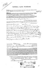
Land Purchase Document, Land Purchase for Samuel George Isaacs of Elizabeth Street, Melbourne for 148 acres, 2 roods and 9 perches in County of Mornington Parish of Ringwood - 1858, Feb-1858
... Land Purchase for Samuel George Isaacs of Elizabeth Street, Melbourne for 148 acres, 2 roods and 9 perches in County of Mornington Parish of Ringwood - 1858....1598 laminated copy on cardboard of Victoria - Land Purchase for Samuel George Isaacs of Elizabeth Street, Melbourne for 148 acres, 2 roods and 9 perches in County of Mornington Parish of Ringwood for the sum of 148 pounds 11 shillings and two pence. ...+Additional Keywords: Isaacs, Samuel George Land Purchase for Samuel George Isaacs of Elizabeth Street, Melbourne for 148 acres, 2 roods and 9 perches in County of Mornington Parish of Ringwood - 1858. Land Purchase Document ...1598 laminated copy on cardboard of Victoria - Land Purchase for Samuel George Isaacs of Elizabeth Street, Melbourne for 148 acres, 2 roods and 9 perches in County of Mornington Parish of Ringwood for the sum of 148 pounds 11 shillings and two pence. +Additional Keywords: Isaacs, Samuel Georgeas above -
 Emerald Museum & Nobelius Heritage Park
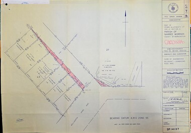
Map - Municipality Road Classification - Shire of Sherbrooke, Belgrave-Gembrook Rd. near Paradise Hotel, Part of Crown Allotments 27 & 43 Section A, Parish of Naree Worran, County of Mornington, c1978
... Part of Crown Allotments 27 & 43 Section A, Parish of Naree Worran, County of Mornington...Title Survey Division/Crown Description/Part of Allotments 27 and 43 Section A, Parish of Naree Worran, county of Mornington/AMG reference 7922'55 361300 5800700/Municipality Road Classification/Shire of Sherbrooke Belgrave-Gembrook Rd....Clarke (signed) Principal Surveyor and Proper Officer 27.2.78/SP14137 Image of map indication road classification for Belgrave-Gembrook Rd., Clematis c1978 Part of Crown Allotments 27 & 43 Section A, Parish of Naree Worran, County of Mornington Map Municipality Road Classification - Shire of Sherbrooke, Belgrave-Gembrook Rd. near Paradise Hotel ...Alteration to the Belgrave-Gembrook Rd., near the Paridise Valley Hotel 1978Image of map indication road classification for Belgrave-Gembrook Rd., Clematis c1978Title Survey Division/Crown Description/Part of Allotments 27 and 43 Section A, Parish of Naree Worran, county of Mornington/AMG reference 7922'55 361300 5800700/Municipality Road Classification/Shire of Sherbrooke Belgrave-Gembrook Rd./Approved S.R. Clarke (signed) Principal Surveyor and Proper Officer 27.2.78/SP14137 -
 Ringwood and District Historical Society
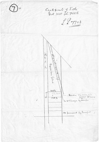
Document - Subdivision Notes, Certificate of Title - LP7703 Mary Ann Williams, Bedford Road Ringwood, County of Mornington dated 18/4/1912
... Certificate of Title - LP7703 Mary Ann Williams, Bedford Road Ringwood, County of Mornington dated 18/4/1912....Mary Ann Williams of Bedford Road Ringwood in the County of Mornington, wife of John Williams of the same place, Gardener, is now the proprietor of and estate in fee simple subject to the encumbrances notified herunder in all that piece of land deliniated and coloured red on the map in the margin, containing 72 acres 3 roods and 30 perches of thereabouts being parts of Crown Portion 16, Parish of Ringwood, County of Mornington, together with a right of carriage way over the road coloured brown on the said map. 18/4/1912. ...Certificate of Title - LP7703 Mary Ann Williams, Bedford Road Ringwood, County of Mornington dated 18/4/1912. Document Subdivision Notes ...Three pages of notes and subdivision sketches on tracing paper.Mary Ann Williams of Bedford Road Ringwood in the County of Mornington, wife of John Williams of the same place, Gardener, is now the proprietor of and estate in fee simple subject to the encumbrances notified herunder in all that piece of land deliniated and coloured red on the map in the margin, containing 72 acres 3 roods and 30 perches of thereabouts being parts of Crown Portion 16, Parish of Ringwood, County of Mornington, together with a right of carriage way over the road coloured brown on the said map. 18/4/1912. Encumbrances - special railway conditions contained in Crown Grant to Nelson Polak. Transfer to Elizabeth Anne Yelland 10/9/1918 Transfer to Mary M Savage 16/5/1912 (?) Easement - Emma Blood 8/10/1919 (?) Turner - 12/3/1924 18 Greenwood Avenue 3/7/1915 Caveat no.63960 25/8/1924 -
 Emerald Museum & Nobelius Heritage Park
Map - Survey Map - Municipality Road Classification - Beaconsfield-Emerald Rd. (near Downey Rd.) 1972, Title Survey Division, Crown Description - part of Crown Allotments 39A and 39D, Parish of Gembrook, County of Mornington, c1972
... Title Survey Division, Crown Description - part of Crown Allotments 39A and 39D, Parish of Gembrook, County of Mornington...Title Survey Division/Crown Description/Part of Crown Allotments 39A and 39D, Parish of Gembrook,County of Mornington/Municipality Road Classification - Shire of Berwick, Beaconsfield - Emerald Rd, Upper Beaconsfield - Upper Pakenham Road/John L Dwyer of Fisher Cleeland Turner & Dwyer Pty. ...Emerald Museum & Nobelius Heritage Park 5 Crichton Rd Emerald yarra-valley-and-the-dandenong-ranges Title Survey Division/Crown Description/Part of Crown Allotments 39A and 39D, Parish of Gembrook,County of Mornington/Municipality Road Classification - Shire of Berwick, Beaconsfield - Emerald Rd, Upper Beaconsfield - Upper Pakenham Road/John L Dwyer of Fisher Cleeland Turner & Dwyer Pty. ...Image of Crown survey map - changes to allotments bordering Beaconsfield-Emerald Rd. near Downey Rd. in 1972Title Survey Division/Crown Description/Part of Crown Allotments 39A and 39D, Parish of Gembrook,County of Mornington/Municipality Road Classification - Shire of Berwick, Beaconsfield - Emerald Rd, Upper Beaconsfield - Upper Pakenham Road/John L Dwyer of Fisher Cleeland Turner & Dwyer Pty. Ltd., 213 King Street, Melbourne - 14 April, 1972/S.R. CLARKE - Principal Title Survey Officer 5.9.72/SP 13072 -
 Queenscliffe Maritime Museum
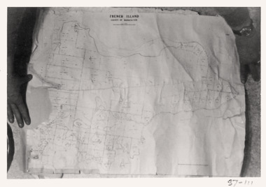
Map - French Island, County of Mornington, French Island map photographs x 2, c1987
... French Island, County of Mornington...Queenscliffe Maritime Museum 2 Wharf St Queenscliff geelong-and-the-bellarine-peninsula Islands off Victorian coast French Island map French Island Reverse " Nil " French Island map photographs x 2 French Island map photographs x 2 Map French Island, County of Mornington ...Islands off Victorian coastFrench Island mapFrench Island map photographs x 2Reverse " Nil "french island -
 Ringwood and District Historical Society
Map - Parish of Ringwood, County of Mornington, Victoria, Original Land Owners
... Parish of Ringwood, County of Mornington, Victoria....Map Parish of Ringwood, County of Mornington, Victoria. ...Laminated Parish map of Ringwood detailing original Land Owners' names, property locations and acreages. Details reproduced in 1957 by the Department of Lands and Survey, Melbourne, from original surveys of varying dates. -
 Ringwood and District Historical Society
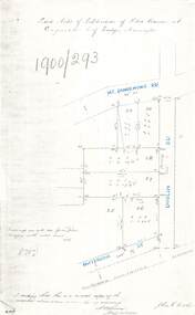
Document - Copy of Lands Department Field Notes - Subdivision of Police Reserve at Ringwood, County of Mornington, Field Notes 1900/293 - Part of O.P. R72C surveyed 1900
... Copy of Lands Department Field Notes - Subdivision of Police Reserve at Ringwood, County of Mornington...R72C surveyed 1900 Document Copy of Lands Department Field Notes - Subdivision of Police Reserve at Ringwood, County of Mornington ...Foolscap size photocopy of survey map with handwritten notations. References include Mount Dandenong Road, Dublin Road, Patterson Street, Melbourne to Lilydale railway line, I certify that this is a correct copy of recorded observations made by my assistant (signed) W. Thorn, Staff Surveyor. -
 Ringwood and District Historical Society
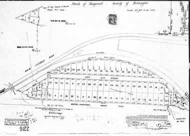
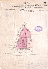
Document, Map - Parish of Ringwood, County of Mornington (Plan of Subdivision, Part of Crown Portion 11) - 1888
... Map - Parish of Ringwood, County of Mornington (Plan of Subdivision, Part of Crown Portion 11) - 1888...A4 photocopy showing numbered allotments abutting the railway line, fronting Pitt Street, and Bedford Road (previously Ferntree Gully Road) Map - Parish of Ringwood, County of Mornington (Plan of Subdivision, Part of Crown Portion 11) - 1888 Document ...A4 photocopy showing numbered allotments abutting the railway line, fronting Pitt Street, and Bedford Road (previously Ferntree Gully Road)Map accuracy certification date - 27th August 1888. Road name amended from Ferntree Gully Road to Bedford Road 8.4.1930. Later re-subdivision notations included on 26.2.1946. -
 Ringwood and District Historical Society
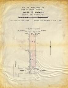
Map - Plan of Subdivision, Part of Crown Portions 6 Parish of Ringwood, County of Mornington - (Undated, circa 1950s)
... Part of Crown Portions 6 Parish of Ringwood, County of Mornington - (Undated, circa 1950s)...Part of Crown Portions 6 Parish of Ringwood, County of Mornington - (Undated, circa 1950s) Map Plan of Subdivision ...Copy of land title map on light cardboard backing showing layout and imperial sizes of 2 residential allotments in Arlington Street and Barkly Street, Ringwood, Victoria. -
 Ringwood and District Historical Society
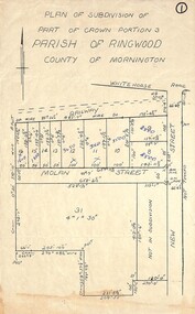
Map, Plan of Subdivision - Part of Crown Portion 3, Parish of Ringwood, County of Mornington (Undated, circa 1930s)
... Plan of Subdivision - Part of Crown Portion 3, Parish of Ringwood, County of Mornington (Undated, circa 1930s)...Plan of Subdivision - Part of Crown Portion 3, Parish of Ringwood, County of Mornington (Undated, circa 1930s) Map ...Hand-drawn map of subdivided allotments in Molan Street and New Street Ringwood, south of railway line.Real estate sales notations on some allotments possibly added post decimal currency changeover date, 1966. Weatherboard shop marked on south-west corner of New Street and Whitehorse Road. -
 Ringwood and District Historical Society
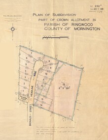
Map - Plan of Subdivision, Part of Crown Allotment 39, Parish of Ringwood, County of Mornington - 1968
... Part of Crown Allotment 39, Parish of Ringwood, County of Mornington - 1968...Part of Crown Allotment 39, Parish of Ringwood, County of Mornington - 1968 Map Plan of Subdivision ...Map showing residential allotments numbered 1 to 14 Headline Court, Heathmont, Victoria, off Bronaldi Street and Yallamba Place. Adjoining lot 15 marked as 2 acres 3 roods 29.8 perches with house and garage.Paul Millar & Associates, Land & Engineering Surveyors, First Floor, 14A Main Street Croydon (Phone) 723 4493. Ref. 232B Date 23.1.68 Amended 12.3.68 & 1.12.71. -
 Ringwood and District Historical Society
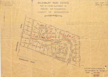
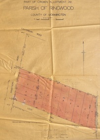
Map - Plan of Subdivision, Aylesbury Park Estate, Part of Crown Allotment 39, Parish of Ringwood, County of Mornington - 1970
... Aylesbury Park Estate, Part of Crown Allotment 39, Parish of Ringwood, County of Mornington - 1970....Aylesbury Park Estate, Part of Crown Allotment 39, Parish of Ringwood, County of Mornington - 1970. Map Plan of Subdivision ...Map showing residential allotments for sale in Armstrong Road, Danielle Crescent and Locksley Close, Heathmont, Victoria.Ref.532A Date 13.4.70. Paul Millar & Associates, Land & Engineering Surveyors, 14A Main Street Croydon (Phone) 723 4493. Ref.532A Date 13.4.70. (Agent) H.G. McLean & Assoc P/L, 166 Canterbury Road Heathmont, Phone 8703422 A.H. 8706726 8700112. -
 Ringwood and District Historical Society
Map - Plan of Subdivision, Part of Crown Allotment 40B, Parish of Ringwood, County of Mornington - 1965
... Part of Crown Allotment 40B, Parish of Ringwood, County of Mornington - 1965...Part of Crown Allotment 40B, Parish of Ringwood, County of Mornington - 1965 Map Plan of Subdivision ...Map showing residential allotments numbered 1 to 5 on Heathmont Road and The Greenway, Heathmont, Victoria.Ref. 2937A Date 19 July 1965. Kirkpatrick & Webber, Licensed Surveyors, Civil Engineers & Town Planners, Maroondah Highway, Ringwood Telephone 870 0321. -
 Ringwood and District Historical Society
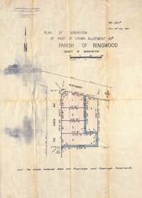
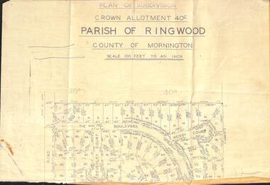
Document - Plan of Subdivision, Part of Crown Allotment 40C, Parish of Ringwood, County of Mornington - (Undated, circa 1960s)
... Part of Crown Allotment 40C, Parish of Ringwood, County of Mornington - (Undated, circa 1960s)...Part of Crown Allotment 40C, Parish of Ringwood, County of Mornington - (Undated, circa 1960s) Document Plan of Subdivision ...Top portion (only) of clipped map on light paper backing showing residential allotments on The Boulevard, Wendy Court and Beverley Court, Heathmont, Victoria. -
 Ringwood and District Historical Society
Map - Plan of Subdivision, Part of Crown Allotment 39, Parish of Ringwood, County of Mornington - 1949
... Part of Crown Allotment 39, Parish of Ringwood, County of Mornington - 1949...Part of Crown Allotment 39, Parish of Ringwood, County of Mornington - 1949 Map Plan of Subdivision ...Map showing residential allotments numbered 1 to 12 on Armstrong Road and Louis Street, Heathmont, Victoria.Certification signed and dated by Russell Francis Kinnane, Licensed Surveyor, 18th February, 1949. -
 Ringwood and District Historical Society
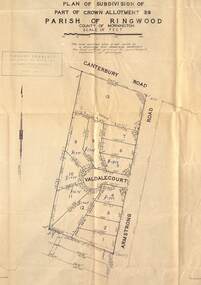
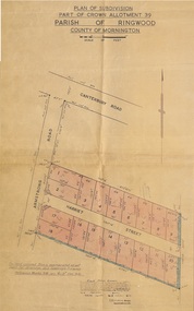
Map - Plan of Subdivision, Part of Crown Allotment 39, Parish of Ringwood, County of Mornington - (Undated, circa 1950)
... Part of Crown Allotment 39, Parish of Ringwood, County of Mornington - (Undated, circa 1950)....Part of Crown Allotment 39, Parish of Ringwood, County of Mornington - (Undated, circa 1950). Map Plan of Subdivision ...Map showing residential allotments numbered 1 to 13 on Valdale Court and Armstrong Road off Canterbury Road, Heathmont, Victoria. Richard Rogalsky, Land Surveyor and Town Planner, 25 Napier Street, Essendon (at Essendon Junction) 37-2642 - 37-6570. -
 Ringwood and District Historical Society
Map - Plan of Subdivision, Part of Crown Allotment 39, Parish of Ringwood, County of Mornington - 1949
... Part of Crown Allotment 39, Parish of Ringwood, County of Mornington - 1949...Part of Crown Allotment 39, Parish of Ringwood, County of Mornington - 1949 Map Plan of Subdivision ...Map showing residential allotments numbered 1 to 18 on Armstrong Road and Harriet Street, Heathmont, Victoria.Certification signed and dated by Russell Francis Kinnane, Licensed Surveyor, 12th October, 1949. -
 Ringwood and District Historical Society
Map - Plan of Subdivision, Part of Crown Allotment 4, Parish of Ringwood, County of Mornington - 1925, amended 1980
... Part of Crown Allotment 4, Parish of Ringwood, County of Mornington - 1925, amended 1980....Part of Crown Allotment 4, Parish of Ringwood, County of Mornington - 1925, amended 1980. Map Plan of Subdivision ...Photocopy of subdivision with allotment numbers and property dimensions. Subdivision includes Grant Crescent, Heatherbrae Avenue, Margaret Street, Mary Street, Hillcrest Avenue, Bon View Avenue and Whitehorse Road, Ringwood, Victoria.W.B. & O. McCutcheon Stamp 13.1.25. Declared by W.J. Bonwick 24.12.24. Amended 15.8.80. LP Ref 10506. -
 Ringwood and District Historical Society
Map - Plan of Subdivision, Part of Crown Allotment 4, Parish of Ringwood, County of Mornington - 1925
... Part of Crown Allotment 4, Parish of Ringwood, County of Mornington - 1925...Part of Crown Allotment 4, Parish of Ringwood, County of Mornington - 1925 Map Plan of Subdivision ...Photocopy of subdivision with allotment numbers and property dimensions. Subdivision includes Grant Crescent, Heatherbrae Avenue, Bon View Avenue, Burwood Avenue, Sherbrook Avenue and Whitehorse Road, Ringwood, Victoria. Area west of Bon View Avenue marked Electrical Commission East, Excised.W.B. & O. McCutcheon Stamp 13.1.25. Declared by W.J. Bonwick 24.12.24. Councis's consent on plan with F.D3 report. LP Ref 10507. -
 Ringwood and District Historical Society
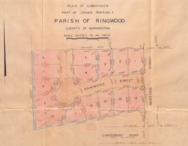
Map - Plan of Subdivision, Part of Crown Portion 7, Parish of Ringwood, County of Mornington - 1966
... Part of Crown Portion 7, Parish of Ringwood, County of Mornington - 1966...Map showing layout of and dimensions of 15 numbered allotments on Hammond Street, off Maidstone Street, Ringwood, Victoria Part of Crown Portion 7, Parish of Ringwood, County of Mornington - 1966 Map Plan of Subdivision ...Map showing layout of and dimensions of 15 numbered allotments on Hammond Street, off Maidstone Street, Ringwood, VictoriaRichard Rogalsky, Licensed Surveyor, 23 Napier Street, Essendon (Telephone) 37-2642, 37-2257, Ref 66/821. -
 Ringwood and District Historical Society
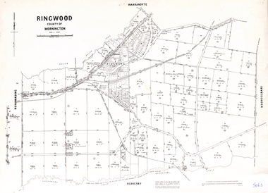
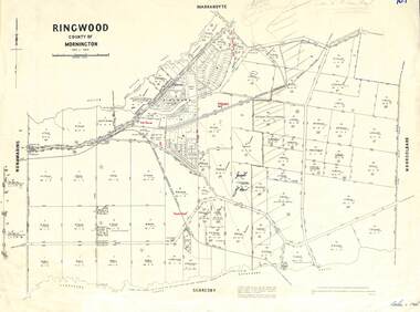
Map - 1957 Reproduction of Plan of Survey, Parish of Ringwood, County of Mornington
... Parish of Ringwood, County of Mornington...Parish of Ringwood, County of Mornington Map 1957 Reproduction of Plan of Survey ...Updated original 1878 map with names of early selectors in area bounded by Nunawading, Warrandyte, Scoresby and Mooroolbark, and Mullum Mullum & Dandenong Creeks.Authorised by W.M. Houston, Government Printer, Melbourne. Drawn and reproduced at the Department of Lands and Survey, Melbourne - 1957. -
 Ringwood and District Historical Society
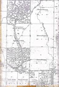
Map, Partial Extract of Department of Lands and Survey Map, County of Mornington - 1955
... Partial Extract of Department of Lands and Survey Map, County of Mornington - 1955...Partial Extract of Department of Lands and Survey Map, County of Mornington - 1955 Map ...Two sections of original Crown Portions survey map of Ringwood and Mooroolbark separated along fold lines. -
 Ringwood and District Historical Society
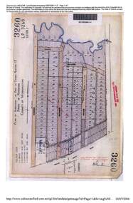
Map - Plan of Subdivision, Part of Crown Portion 12, Parish of Ringwood, County of Mornington - circa 1880s
... Part of Crown Portion 12, Parish of Ringwood, County of Mornington - circa 1880s...Part of Crown Portion 12, Parish of Ringwood, County of Mornington - circa 1880s Map Plan of Subdivision ...2006 LANDATA photcopy of original subdivision map of 144 allotments in Ringwood Street, Hobart Street, Brisbane Street, Melbourne Street, Adelaide Street, Warrandyte Road and White Horse road, Ringwood. Hatched shading marks area redevelopment and roads discontinued by 1980s.LP3260, LP9589, LP17037, LP29340, LP17774, LP12622, LP5704 -
 Ringwood and District Historical Society
Map, Subdivision Plan - Crown Allotment 20 Section E, Parish of Ringwood, Township of Ringwood, County of Mornington. (Undated, circa 1920s)
... Subdivision Plan - Crown Allotment 20 Section E, Parish of Ringwood, Township of Ringwood, County of Mornington. (Undated, circa 1920s)....Subdivision Plan - Crown Allotment 20 Section E, Parish of Ringwood, Township of Ringwood, County of Mornington. (Undated, circa 1920s). Map ...Wax/parchment paper printout of numbered subdivision allotments and store, corner of Mount Dandenong Road and Braeside Avenue, Ringwood.Rubber-stamped with circa 1920s stamp of W.J. Bonwick, Licensed Surveyor, 19 Clarence Street, East Malvern, Telephone U4833. -
 Ringwood and District Historical Society
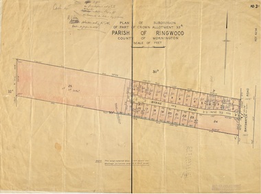
Map, Plan of Subdivision - Part of Crown Allotment 33A, Parish of Ringwood, County of Mornington - (Undated, circa 1920s-30s)
... Plan of Subdivision - Part of Crown Allotment 33A, Parish of Ringwood, County of Mornington - (Undated, circa 1920s-30s)....Plan of Subdivision - Part of Crown Allotment 33A, Parish of Ringwood, County of Mornington - (Undated, circa 1920s-30s). ...Map showing layout of 24 numbered allotments in Byrne Road, off Bayswater Road, North Bayswater, Victoria.Rubber-stamped Garlick and Stewart Engineers and Surveyors, Melbourne. Handwritten price notations ranging between £65-£300. Terms 3 years on £50 deposit at 4-1/2% 6 months. K.P. Rees Solicitors acting for the vendor. -
 Ringwood and District Historical Society
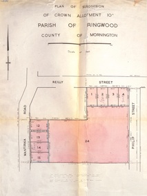
Document, Plan of Subdivision - Part of Crown Allotment 10A, Parish of Ringwood, County of Mornington - 1957
... Plan of Subdivision - Part of Crown Allotment 10A, Parish of Ringwood, County of Mornington - 1957...Plan of Subdivision - Part of Crown Allotment 10A, Parish of Ringwood, County of Mornington - 1957 Document ...Map of residential allotments in Wantirna Road and Reilly Street, Ringwood, and Philip Street, Heathmont, Vic.Footnote includes "Lots numbered 5 to 11 and 16 to 23 both inclusive are not included in this plan. Signature of Consulting Engineer - Alan J. Brown BCE, LS, MVIS, Licensed Surveyor, Dillons Buildings, 1 Riversdale Road, Camberwell (Phone) WF3528 dated 1-4-1957. -
 Ringwood and District Historical Society
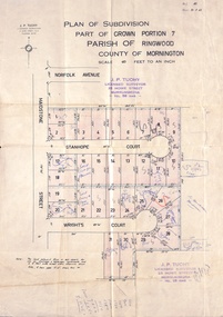
Document, Plan of Subdivision - Part of Crown Portion 7, Parish of Ringwood, County of Mornington - 1962
... Plan of Subdivision - Part of Crown Portion 7, Parish of Ringwood, County of Mornington - 1962...Plan of Subdivision - Part of Crown Portion 7, Parish of Ringwood, County of Mornington - 1962 Document ...Map of residential allotments coloured red, with land coloured blue set apart for drainage & sewerage easements. Rubber stamped J.P. Tuohy, Licensed Surveyor, 25 Howe Street Murrumbeena, Tel. 561945, dated 38.8.1962.Map includes Maidstone Street, Norfolk Avenue, Stanhope Court and Wrights Court, Ringwood, Vic. Also includes handwritten Estate Agent sales notations.