Showing 157 items matching "crown land survey"
-
 Bendigo Historical Society Inc.
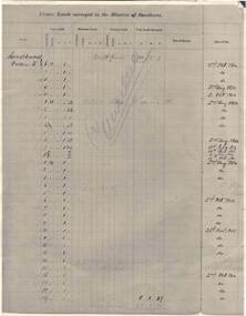
Document - RAILWAYS COLLECTION: CROWN LANDS SURVEYED IN DISTRICT OF SANDHURST
... ...Crown Land Survey...DOCUMENT Crown Land Survey RAILWAYS COLLECTION -large cream -coloured paper photocopy of 'Crown Lands Surveyed in District of Sandhurst' x 2 Information has been entered into columns showing Parish, Town Lands, Suburban Lands, Country Lands, Total Lands Surveyed, Date of Survey, Date of Sale, most Dates of Sale are 1854 The documents have been cancelled. ...RAILWAYS COLLECTION -large cream -coloured paper photocopy of 'Crown Lands Surveyed in District of Sandhurst' x 2 Information has been entered into columns showing Parish, Town Lands, Suburban Lands, Country Lands, Total Lands Surveyed, Date of Survey, Date of Sale, most Dates of Sale are 1854 The documents have been cancelled.document, crown land survey -
 University of Melbourne, Burnley Campus Archives
Plan, Royal Botanic Gardens Melbourne, 1978
... Department of Crown Land and Survey Division of Survey and Mapping...University of Melbourne, Burnley Campus Archives 500 Yarra Boulevard Richmond melbourne jeremy j. wallace royal botanical gardens melbourne Department of Crown Land and Survey Division of Survey and Mapping ornamental lakes Plan of RBG with grid references. ...Plan of RBG with grid references. Produced by Dept. of Crown Lands and Survey, Victoria, Division of Survey and Mapping. Prepared in 1978 from surveys completed in 1976. (1) 2 copies plan. Main areas, buildings, etc., labelled, beds outlined. (2) Original coloured plan and reduced size photocopy. More labelling, particularly beds (handwritten). Labelled Jeremy J. Wallace with handwritten notes on reverse re a project. (3) Reduced size photocopy. Handwritten labelling of beds. (4 - 11) Enlarged photocopies of sections of (1) Handwritten notes and plant labelling. (1). Photgraphed copies by FRESCO 510131-TA. (12) Plan on a grid, coloured. "No Public Access," areas marked.jeremy j. wallace, royal botanical gardens melbourne, department of crown land and survey division of survey and mapping, ornamental lakes -
 Bendigo Historical Society Inc.
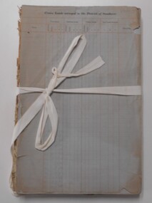
Document - LANDS OFFICE - CROWN LANDS SURVEYED AND SOLD SANDHURST - 1857 - 1879, 1857 - 1879
... Contains details of crown land surveyed and sold, district of Sandhurst. ...Contains details of crown land surveyed and sold, district of Sandhurst. ...Journal: black hard cover with buff spine and corners. Contains details of crown land surveyed and sold, district of Sandhurst. Double pages numbered on top right, page columns - parish, town lands, particulars, survey fees, date of survey, date of sale, auction, selection price per acre, total amount, purchaser. No index. On spine '08' 'Bendigo A' 26th June 1857 to 1879 (?)Lands Officeplace, land sales, lands office, crown land, land surveys, bendigo, sandhurst -
 Bendigo Historical Society Inc.
Document - LANDS OFFICE - CROWN LANDS SURVEYED AND SOLD SANDHURST, 1860 onwards
... Journal: LANDS OFFICE - CROWN LANDS SURVEYED AND SOLD SANDHURST green hard cover journal with buff spine and corners. Contains details of crown land surveyed and sold in the district of Sandhurst. ...Contains details of crown land surveyed and sold in the district of Sandhurst. ...Journal: LANDS OFFICE - CROWN LANDS SURVEYED AND SOLD SANDHURST green hard cover journal with buff spine and corners. Contains details of crown land surveyed and sold in the district of Sandhurst. Indexed in front by parish, alphabetical double pages not numbered. On LH page, parish, town, suburban, country, date of survey. On RH page, date of sale, auction, selection, price, total amount, purchaser. On spine ' index book' 'F' and '09'. Dated from 1860 onwardsLands Officeland sales, bendigo -
 Bendigo Historical Society Inc.
Book - CROWN LAND SALES: RECORDS OF SALE 1860 - 1865
... On top of LH page: Crown Land surveyed in the District of Sandhurst. ...On top of LH page: Crown Land surveyed in the District of Sandhurst. ...Land sale journal, blue lined pages, no cover. On top of LH page: Crown Land surveyed in the District of Sandhurst. On top of RH page: Crown Lands sold in the District of Sandhurst' Entries contain details of town lands, suburban lands, country lands, total lands surveyed and date of survey. Date of sale, by auction, by selection and total amount paid. Names of purchasers listed. Entries date from 1860 - 1865. Written across all pages in blue pencil 'Cancelled' and a date for each cancellation: Wm. Rundell 8.9.80.bendigo, land sales, sandhurst -
 Brighton Historical Society
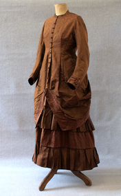
Clothing - Dress, Day dress, circa 1875-1876
... The Blundell family were active members of the Brighton Congregational Church and supported the construction of the Black Street church, where James Jr served as a deacon for sixty years, in addition to his work in the Crown Land and Survey Department. The dress is believed to have been made for Jane in 1875 or 1876 during her early pregnancy, likely by a local dressmaker. ...The Blundell family were active members of the Brighton Congregational Church and supported the construction of the Black Street church, where James Jr served as a deacon for sixty years, in addition to his work in the Crown Land and Survey Department. The dress is believed to have been made for Jane in 1875 or 1876 during her early pregnancy, likely by a local dressmaker. ...This dress belonged to Ethel Nina Blundell (1876-1949), having been first made for her mother Jane Blundell (nee Burkitt, 1845-1878). Born in Dublin, Jane married James John Blundell Jr at the Black Street Congregational Church in Brighton on 16 March 1874. The Blundells were a socially prominent Brighton family who played an important role in the development of the area. James' father, publisher and bookseller James John Blundell Sr, served as a Brighton Borough Councillor between 1862 and 1867 when the local government was still in its formative years, including holding the position of Mayor in 1864. He was involved in the foundation of the Brighton Volunteer Rifle Corps and was also a strong supporter of the Brighton Ladies Benevolent Society. The Blundell family were active members of the Brighton Congregational Church and supported the construction of the Black Street church, where James Jr served as a deacon for sixty years, in addition to his work in the Crown Land and Survey Department. The dress is believed to have been made for Jane in 1875 or 1876 during her early pregnancy, likely by a local dressmaker. Jane died in 1878 when Ethel was very young, and Ethel was then raised by her father and paternal grandmother. As she never married, Ethel remained living in the family home of 'Eumana', 164 Church Street, and as an adult she assumed the role of hostess whenever she or her father had guests. On these occasions, she reportedly wore her mother's dress. The family home was sold on James Jr’s death in 1924 and Ethel was living at 52 Black Street Brighton when she died in 1949. In the 1930s, Ethel gifted the dress to a close family friend, Dr Jean Kelly. She told Jean that the garment held precious memories, perhaps due to the connection it provided to the mother she had never known. Jean donated the dress to the Merimbula Old School Museum in NSW in 1987, where it was on display for many years. The Museum donated the dress to Brighton Historical Society in 2023.This is a good example of a late nineteenth century day dress, made from two different patterns of russet brown silk brocade and featuring a lobster tail style bustle. The lack of boning combined with waist and hip measurements indicates it may have been made as a maternity dress. It is lined with beige leaf pattern cotton fabric. The princess line fitted bodice of herringbone pattern brocade has a high round neck with small 'mandarin' style collar and buttons down the front to below the waist where it forms an overskirt which is bordered with a band of coffee bean patterned brocade. The overskirt drops down to hem length at the back but from the centre front it is draped up to the back to a point below the waist level. Here it is sewn to the edge of the lobster tail style bustle which is also bordered by the coffee bean fabric. There is a concealed pocket with the opening under the right edge of the bustle. The buttons on the front of the dress have a decorative circlet of small blue flowers around a russet silk covered dome. The long sleeves are set in and slightly full with a contrasting three pleat band of coffee bean fabric with an ornamental turn back from the pleats sewn just above the wrist. The skirt section of the dress is in four 20 cm bands of alternate fabric patterns with the top and third band of coffee bean pattern slightly gathered and the second and fourth bands of herringbone forming pleated ruffles.1870s, ethel nina blundell, jane blundell, jane burkitt, eumana -
 Warrnambool and District Historical Society Inc.
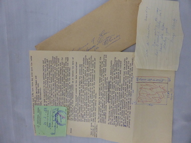
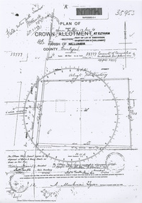
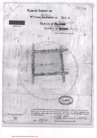
Documents, Swintons Paper att 18/53 Merri St. Contract. Map. Notes, 1959
... The current Swinton business in Timor Street is the oldest family business in Warrnambool and, with the name Swinton associated with businesses in Timor Street Warrnambool for 152 years it is amongst the oldest family businesses in Australia. swinton family, warrnambool .2 ‘Plan of Survey of Part of Crown Allotment 18 Section 3 Township of .2 ‘Plan of Survey of Part of Crown Allotment 18 Section 3 Township of Warrnambool Parish of Wangoom County of Villiers’ .3 ‘Tuesday Dear Mr Swinton I am writing to say that I would like to have the ‘Office’ Thanking You George O’Grady’ The items here relate to the sale of land by Swintons Pty Ltd., Warrnambool. .1 These are three pages of white paper with typed material, a lawyer’s signature in blue ink, one green stamp and a sketch of the land location. .2 This is a sheet of thick paper containing a plan of the land sold. ...These documents relate to the sale of land in Merri Street Warrnambool in 1959 by Swintons Pty Ltd of Warrnambool. The buyer of the land was George O’Grady, a Warrnambool baker. The land sold for £4000 and there was a shed on the land (called the ‘Office’) which George O’Grady indicated he wished to be included in the sale. William and Ann Swinton migrated to Australia in 1854 and for a decade William Swinton worked as a builder and carpenter in the Warrnambool area, erecting many buildings, including the Wangoom Presbyterian Church. In 1865 he opened a store in Timor Street Warrnambool, selling groceries, hardware, china and glassware. By 1888 the business was known as William Swinton and Sons. Branch stores were opened in Wangoom, Cudgee, Nullawarre, South Warrnambool and West Warrnambool. After William Swinton died his son Robert became the first managing director of Swintons Pty Ltd. In 1934 the business split with George Swinton and Sons selling clothing, furnishings and glassware and Swintons Pty Ltd selling seeds, produce and hardware. Today the Swinton family still operates a furniture and bedding shop in Timor St Warrnambool.These items are of some interest as being connected to the Warrnambool business of Swintons Pty Ltd. They will be of interest to researchers. The current Swinton business in Timor Street is the oldest family business in Warrnambool and, with the name Swinton associated with businesses in Timor Street Warrnambool for 152 years it is amongst the oldest family businesses in Australia.The items here relate to the sale of land by Swintons Pty Ltd., Warrnambool. .1 These are three pages of white paper with typed material, a lawyer’s signature in blue ink, one green stamp and a sketch of the land location. .2 This is a sheet of thick paper containing a plan of the land sold. The paper has printed material and a sketch of the land with part of it coloured in pink. .3 This is a small piece of paper torn at the bottom right edge. It has handwritten material (a letter) in blue ink..2 ‘Plan of Survey of Part of Crown Allotment 18 Section 3 Township of .2 ‘Plan of Survey of Part of Crown Allotment 18 Section 3 Township of Warrnambool Parish of Wangoom County of Villiers’ .3 ‘Tuesday Dear Mr Swinton I am writing to say that I would like to have the ‘Office’ Thanking You George O’Grady’swinton family,, warrnambool -
 Emerald Museum & Nobelius Heritage Park
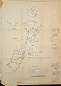
Map - Acquire & declare action for Belgrave-Gembrook Rd., Emerald 1988, Acquire & declare action for Belgrave-Gembrook Rd., Emerald 1988. near Beaconsfield-Emerald Rd. and Emerald Monbulk Rd, c1988
... Land Information and Survey Group/Plan of Survey/Counties of Evelyn and Mornington, Parish of Gembrook, Township of Emerald, Part of a Frmer Govt. Road Section A, Part of Crown...Emerald Museum & Nobelius Heritage Park 5 Crichton Rd Emerald yarra-valley-and-the-dandenong-ranges Land Information and Survey Group/Plan of Survey/Counties of Evelyn and Mornington, Parish of Gembrook, Township of Emerald, Part of a Frmer Govt. Road Section A, Part of Crown ...Image of Map of Acquire & declare action for Belgrave-Gembrook Rd., Emerald 1988 near Beaconsfield-Emerald Rd. and Emerald Monbulk Rd.Land Information and Survey Group/Plan of Survey/Counties of Evelyn and Mornington, Parish of Gembrook, Township of Emerald, Part of a Frmer Govt. Road Section A, Part of Crown Allotment 18, Part of Recreation reserve (Crown Allotment 11C), Part of mechanics Institute & Free Library reserve (Crown Allotment 11B)/AMG Reference 7922/55/363 200/5800700/Municipality - Shire of Sherbrooke/Proposed Action/Belgrave -Gembrook Road acquire & Declare 1 & 4 to 6, revoke and declare 2 & 3.Albert McLaren Road Construction Authority, 60 Denmark Street, Kew/(signed) 5TH December 1988 a.m. LARSEN, licensed surveyor/Approved JD MURRAY, 9/12/88 - Manager - Land Information and Survey Group/SP17861 -
 Emerald Museum & Nobelius Heritage Park
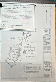
Map - Plan of Survey Acquire & Declare Proposed Action Belgrave-Gembrook Rd., Shire of Sherbrooke, Plan of Survey acquire and declare proposed action, Belgrave-Gembrook Rd, c1988
... SP17861/Land Information and survey Group/Plan of Survey/Counties of Evelyn and Mornington, Parish of Gembrook, Township of Emerald, part of former Govt. Road Section A Part of Crown...Emerald Museum & Nobelius Heritage Park 5 Crichton Rd Emerald yarra-valley-and-the-dandenong-ranges SP17861/Land Information and survey Group/Plan of Survey/Counties of Evelyn and Mornington, Parish of Gembrook, Township of Emerald, part of former Govt. Road Section A Part of Crown ...Image of Plan of Survey Acquire & Declare Proposed Action Belgrave-Gembrook Rd., Shire of SherbrookeSP17861/Land Information and survey Group/Plan of Survey/Counties of Evelyn and Mornington, Parish of Gembrook, Township of Emerald, part of former Govt. Road Section A Part of Crown Allotment 18, Part of recreation Reserve (Crown Allotment 11C), Part of mechanics Institute & Free Library reserve (Crown Allotment 11B)/AMG REFERENCE 7922/55/363200/5800700/municipality, shire of Sherbrooke/Proposed Action, Belgrave-Gembrook Road Acquire & Declare 1 & 4 to 6, revoke & declare 2 & 3/Albert McLaren, Road Construction Authority, 60 Denmark Street, Kew 5th December 1988, (signed) A M Larson, Licensed Surveyor/Approved JD Murray 9/12/88, Manager - Land Information and Survey Group -
Emerald Museum & Nobelius Heritage Park
Map - Plan of Deviation in Crown Allotments 57 & 58 Wright Rd. & McNamara Rd. 1929, Property Acquisition Settlement Advice and plan of deviation in crown allotments in Wright Rd. and McNamara Rd, C 1929 & C 1984
... /Survey Plan 2239/Owner Roy and Judith Ward/dated 10 September, 1984/Signed P J McCulloch, General Manager Admin/ATTACHED MAP/Plan of Deviation in Crown Allotments 57 & 58and part of the formergovernment road, Parish of Gembrook, county of Evelyn/ certified by W.P. BONWICH - 5.2.29 Images of map and letter pertaining to land ...Images of map and letter pertaining to land acquisition and deviation plan for crown allotments adjacent to Crown Allotments 57 & 58Road Construction Authority/Property Acquisition - Settlement advice letter addressd to General manager of Shire of Sherbrooke, Glanfern Way Upwey/Road - Belgrave-Gembrook Rd./Survey Plan 2239/Owner Roy and Judith Ward/dated 10 September, 1984/Signed P J McCulloch, General Manager Admin/ATTACHED MAP/Plan of Deviation in Crown Allotments 57 & 58and part of the formergovernment road, Parish of Gembrook, county of Evelyn/ certified by W.P. BONWICH - 5.2.29 -
Federation University Historical Collection
Document, Zelda Martin, Central Victorian Goldmining towns - Boom Towns or Ghost Towns?, c1996
... Crown Lands and Survey. * Newspaper articles from The Argus, 1849, re the discovery of gold in the Pyrenees region. * Excerpt - a report on schools - A.B.Orlebar, Inspector; re the need for permanent school buildings rather than tents. *Excerpt from - 'Approaches to Urban History', Sean Glynn: The Case for Caution * Except from - 'The Urban Sprinkle', Weston Bate: Country Towns and Australian Regional History *Reference- 'The History of Land Tenure in the Colony of Victoria', John Quick. ...Crown Lands and Survey. * Newspaper articles from The Argus, 1849, re the discovery of gold in the Pyrenees region. * Excerpt - a report on schools - A.B.Orlebar, Inspector; re the need for permanent school buildings rather than tents. *Excerpt from - 'Approaches to Urban History', Sean Glynn: The Case for Caution * Except from - 'The Urban Sprinkle', Weston Bate: Country Towns and Australian Regional History *Reference- 'The History of Land Tenure in the Colony of Victoria', John Quick. ...Zelda Martin was a PhD candidate at the University of Melbourne.[.1] 4th item in light blue display book titled Research Approach/Overview of Chapters/Confirmation of Canditure/Chapters1,2,3&4 of proposed thesis. *Twenty-seven page article on Victorian goldfields towns titled: Central Victorian Goldmining Towns - Boom Towns or Ghost Towns. The article was written during the author's PhD study. It outlines the context methodology, and resources and the chapters of the proposed thesis: (1) Central Victorian Goldmining Towns - The Context (2) Contemporary Views of the Factors Necessary for Town Growth (3) Outward Manifestations of Town Growth (4) The Trappings of Government (5-9) The Main Towns and Their Hinterland. [.2] 5th item in Light Blue display book as above item. *Chapter 1 of proposed thesis titled 'Pick, Shovel and Tin Dish Mining.' Covers in Section A: Central Victoria - Pre 1851: Aborigines in Central Victoria, Squatters, and Government. Section B: The years 1851-1854: The Early Gold Rushes, Government Reaction, Township Surveys, Legislation, Town Development, Local Government and Early Settlement. [.3] 6th item in Light Blue display book as above item. *2A of proposed thesis titled 'Contemporary Views of the Factors Necessary for Town Growth'. Similar information to Chapter 1 plus extra re towns and maps. Sections: Introduction, Context of Place - Geographical Towns Listed, The Context of Time - Pre1851 Aborigines, Governance of Port Phillip, The Squatters, The Villages of Central Victorian Highlands, Conclusion, Condensed Version of Chapter2B. [.4] 7th item in Light Blue display book as above item. *Chapter2B of proposed thesis. Sections: Area of Research, Schools, Banks, Newspapers, Progress Association, Town Development - Sandhurst (Bendigo), Ballarat, Castlemaine,, Maryborough, Ararat and Stawell. [.5] 8th item in Light Blue display book as above item. *Chapter 3 of proposed thesis titled 'Outward Manifestations of Town Growth'. Sections: Introduction, Contemporary Writing, Educationalists, The Bankers, The Townsfolk, Current Theory, General Theories of Urban Development, and Conclusion. [.6] 9th item in Light Blue display book as above item. *Chapter 4 of proposed thesis titled 'Trappings of Government' Sections: Introduction, Early Government Attitudes to Mining and Town Development, Law and Order, Township Surveys, Legislation, Local Government, Transport and Communication, The People and Lobbyists. [.7] 10th item in Light Blue display book as above item. *'The Rise and Fall of Central Victorian Goldmining Towns'. Includes a map showing main Goldfields, a table showing towns and villages at two points in time - 1857 and 1871; a Bibliography of Primary and Secondary Sources. [.8] Resource No1. Black display book titled Local Towns 1 : Alma: *Brief history *Directory *Maps Amphitheatre / Mountain Hut: *Brief History Post Office Directory Ararat: *Brief History *Post Office Directory 1869 - Alphabetical Listing by Occupation *Ararat - Prominent Citizens of 1858 *Langi-Morgala Museum Avoca: *Brief History *Excerpts from 'Avoca The Early Years', Margery and Betty Beavis; pg1 - Beginnings; pg11 - The Midas Touch; pg25 - Local Gold Escorts; pg27 - A Town is Born; pg51- The Administration of Justice; pg53 - The Ways of the Law; pg61 - News of the Day; pg65 - A Time to Play; pg72 - Land Ownership *Post Office Directory (Bailliere's) 1869 *Tourism Map and Information of area *Historic Avoca - A 5.5km Tour *Avoca & the Pyrenees Region - information pamphlet Ballarat: *Early History of Ballarat - Ballarat Historical Society, Publication No.1: origin of the name; Ballaarat - the Beginning; Fabulous Yields from the Ballaarat Goldfield; *Streetscape Lydiard Street. *Hand drawn map showing Leigh River, Old Portland Bay Road, plaque on road to Colac; etc. *Newspaper article re 'The Theatre Royal' ( which stood in the vicinity of the current Owen Williams store) - 'The News'15/04/1998 *Article - 'Ballarat's Mechanics' Institute Lives On' Ballarat Courier, 14/09/1985 *Article - Standing the Test of Time' The News 17/11/1993 re The Mechanics Institute & picture of the Reading Room *'Ballarat a Study of a City, Phyllis Reichl, pub. Nelson, 1968; no.3 place, time and people field studies series *Investigator Vol.33 No.2, 1998 Geelong Historical Society. Article on pg75 describes Ballarat in 1861 *Folded poster - 'Ballarat 100' a history of telegraph communication, pub. Telecom. Beaufort (Fiery Creek): *Brief history *Post Office Directory [.9] Resource No.2 Black Folder Titled Towns cont.No2 Bendigo (Sandhurst): *'Family & Local History at the Bendigo Library - 1851-2001 150 years of gold'. *Bendigo Government Camp in 1853 illustration; key to sketch and names of Government officers stationed there *Excerpts from 'Bendigo and Vicinity' Adolph Haman *The Bendigo Goldfield Registry - pgs 1-7 Introduction *Excerpt: 'Breaking the Grip' *Excerpt: The Most Go-Ahead Place *Excerpts from 'History of Bendigo' - anti license agitation; laying out of town; proposed railway; gold calls and dividends; the Sandhurst Municipality; journalism *Bibliography Blackwood: *Excerpts from 'Aspects of Early Blackwood - The Goldfield, the Landmarks, the Pioneers' Alan J Buckingham and Margaret F Hitchcock, JG Publishing,1980 Buninyong: *A Brief History *Investigator Vol1 No.2 Feb 1966 Geelong Historical Society. Pg3 - Article re gold escort route - Mt Alexander to Adelaide - (see a simple monument on the Western Highway a few miles out of Horsham. Pg 15 - Ballarat Excursion - re the finding of gold. *Three articles published by Buninyong and District Historical Society Inc: (Magpie Exploration; Finding Gold In The Green Hills; Magpie Exploration; Burnt Bridge to Cargarie to Mt Mercer) *Copies of newspaper articles/items *Buninyong Street Directory Carisbrook: *In the Beginning There Was Carisbrook *The History of the Carisbrook Racecourse Carngham / Snake Valley: *Brief History *Directory Castlemaine: *Directory 1865-1866 - Alphabetical and Street *Poster - Castlemaine A Contemporary Guide "The Great Centre" 1866 - A Contemporary Guide to the Fascinating Past *Pamphlet - Castlemaine District Community Hospital *Map - Castlemaine, Maldon & Surrounding Districts *Map and Information - The Dry Diggings Track - a 55kl walk among historic goldfields relics ( Castlemaine Fryerstown Vaughan Mt Franklin Hepburn Daylesford) *Postcard - Former Court House *Directory 1867 - Alphabetical, Trade [.10] Resource No.3 Grey folder Titled Towns 3 Creswick to Maryborough Creswick: *Brief History *Booklet - "Creswick Cemetery Walk" *Booklet - The Buried Rivers of Gold Heritage Trail Creswick *Creswick Historical Museum Information Sheet *Chronological History of Creswick *Alphabetical Directory of the Borough of Creswick *Creswick's Creek Directory 1856 *Historic Creswick Walking Tour *A Brief Account of the Schools of Creswick - Past and Present *100 Years of Railway Travel in Creswick *The Berry Deep Leads *The Spence Home at Jackass Gully in the Creswick State Forest ( William Guthrie Spence - Pioneer) *The New Australian Mine and the 1882 Disaster *Creswick District News, Issue 7, July August 1999 *The Creswick Miners Walk - Information and Map *Maps Chewton: *Brief History *Directory Clunes: *Brief History *Clunes Street Directory Daylesford: *Brief History *Notable Bushfires in Daylesford District Over More Than a Century - "Black Thursday" 1851; 1862; 1899; the Disastrous Hepburn Fire of 1906; 1939; 1944; 1969. *Post Office Directory -Daylesford and Hepburn Dunolly / Inkerman: *Brief History *Directory *Pamphlet - Goldfields Historical Museum *Pamphlet - Historic Dunolly - Victoria's Best Kept Secret *Map of Gold Workings at Dunolly Area - showing where the main gold rushes occurred *Brief History - Inglewood *Directory - Inglewood - Name Occupation, Dwelling Kingower: *Brief History *Directory - Name / Ocupation / Dwelling Linton / Happy Valley / Piggoreet: *Brief History *Directory - Lintons McIvor: *"A History of the Shire and the Township of Heathcote" by J.O. Randell Majorca: *Brief History *Official Post Office Directory 1869 - Name / Occupation/ Address Maldon (Tarrangower): *Brief History Part 1 *Brief History Part 2 *Post Office Directory *List - Alphabetical Order by Names plus Business and Trade (Tarrangower Times Oct/1858) *List - Alphabetical Order by Trade plus Name and Business *Directory - Name / Occupation / Dwelling Maryborough: *Worsley Cottage - built by Arthur Worsley, a contractor in stonework in 1894 [.11] Resource No. 4 Blue Display Book titled Towns 4 Moliagul to Stawell Moliagul: *Brief History *Moligul Legislative Assembly (Voting?) List - Names and Occupations *Moliagul Victorian Post Office Directory 1868 - Name / Ocupation / Address / Comments *"The Welcome Stranger" gold nugget *The Sunday School *The Welcome Stranger Discovery Walk - information and map Moonambel (Mountain Creek) Redbank *Brief History *List of names extracted from advertisments of the Pioneer and Mountain Creek Advertiser 16/02/1861. *Bailliere's Directory 1869 - Alphabetical List of Name / Occupation / Place St Arnaud: *Brief History Sebastapol: *Brief History *Directory 1869 - Alphabetical by Name; plus occupation and address. Browns and Scarsdale: *Brief History *Browns Street Directory - Name and Occupation Smythesdale: *Brief Description *Smythesdale Street Directory -Name and Occupation Stawell (Pleasant Creek) *Brief History *Victorian Official Post Office Directory - Name /Occupation / Dwelling *Chronology - 1841-1920 *Production of gold statistics - 1879 - 1900 *Big Hill *Extracts from "The Golden Years of Stawell". Chapt 1 - Stawell's Coming Out. Capt. 2 - The Gold Rush. Caapt.3 - Cradle of Democracy. Chapt.4 - The Reefs Becomes Stawell. Chapt. 5 - Rushing In. Chapt.6 - The Pioneers. Chapt 7 - The Decade of Optimism. [.12] Resource No. 5: Blue Display Book titled 'Towns Steiglitz to the The Golden Triangle. Steiglitz: Brief History Victorian Post Office Directory 1869 *Map of Steiglitz *List of maps relevant to Steiglitz history *Information 6 tables of data from "Reports of Mining Surveyors Talbot (Back Creek) Brief History Taradale: Post office Directory 1869 - Name/Occupation/Street. Also list in alphabetical order by Occupation Taradale *Chronological Reference to Taradale Mines *Water - The Coliban System of Waterworks *Joseph Brady *The Syphon Tarnagulla (Sandy Creek) *Brief History *Tarnagulla Businessmen Cameos to give depth to advertisments in 'The Tarnagulla Courier' various issues 1864-1871 *Directory - Name/Occupation /Address *List - Name/Business/Trade Wedderburn (Koorong) *Brief History *List - Name/Occupation The Golden Triangle: *The Early Rushes - Wedderburn / Moliagul / Sandy Creek - Tarnagulla / Jones Creek - Waanyarra / Kingower / Dunolly - Goldsborough / Inglweood *Census of 1857 - Population / Occupations *1858-1871 - A Time of Consolidation- Wedderburn / Moliagul / Sandy Creek- Tarnagulla / Arnold *Census 1871 - Population *Information gleaned from the census data - Demographics / Population / Occupations / marital / Birthplace / Religion / Literacy/ Occupation and Housing Cameos *Graphs - Birthplace of settlers /Male-Female Ratio / Married males / Children under 15 as Percentage of Population / Religion *Census 1857 - Statistical data *Maps *Bibliography [.13] Resource No. 6 - Black Display Book Information and Research in Central Victoria including: *Banking - Research from ANZ Bank Archives *Institutions - also includes articles listed from the Ballarat Times Newspaper *Australian mining History Association - A.M.H.A. Bibliography *Australia's Mining History * Bibliography - Land Surveys Victoria - *1853 Administration (Statistics and Other) includes: schools / ministers of religion / police / military / local administration / licences for sale of spirits / distances between various Victorian gold fields. * Victoria Government Gazette (Copy) - N0. 116, 12/12/1854 includes: Gold Felds Commission of Enquiry & No. 85, 15/09/1854 - Addresses presented to the Lieutenant Governor (Sir Charles Hotham) during his tour through the Gold Fields of Victoria,1854. Addresses on behalf of : the people of Bendigo; Members of the Church of England, Bendigo; Members of the Wesleyan Church on the Bendigo Gold Fields; Bendigo Gold District General Hospital; the Bendigo Prospecting Association; Committee of the Bendigo Local Exhibition; Bendigo District Medical Association; Coloured Americans Resident at Bendigo; German Inhabitants of Bendigo; Landowners, Inhabitants, and Miners of Castlemaine; Inhabitants of Forest Creek; Inhabitants of Heathcote and Gold Miners of McIvor; Residents and landholders of the District of Bacchus Marsh; Inhabitants of Kilmore and Vicinity. *Gold Fields Correspondence 1853: letter from Lieutenant Colonel Valiant, (Officer commanding the Troops in Victoria) to the Lieutenant Governor re threatened disturbance at Sandhurst (Bendigo) regarding the Gold License Fee. * Extracts from a book "Victoria" re Gold Fields Commission of Enquiry involving mainly Ballarat and Castlemaine and a chapter titled 'A Tour to the Victorian Gold-Fields' *Lists of central Victorian newspapers - listed by date published 1851to 1874; by first date available to State Library. *A list of cities and towns showing County, population in 1861 &1871, and municipal status. [.14] Resource no.7. Black display book. *Reference: Papers presented to Parliament Victoria - 1859-1860 4 volumes - relevant sections copied. Contains information on Branches of Government. General / Finance / Gold / Gazette / Commission and Warrant / Statistic. *Gold Fields Act. In accordance with the Act the gold fields are divided into six districts - Ballaarat, Castlemaine , Sandhurst, Avoca, Ararat, and Beechworth.. Official staff in each gold district consists of a Resident Warden, Wardens, Wardens' Clerks, Bailiffs, Chinese Protectors, Chinese Interpreters, and Mining Surveyors. *Gold Receiver *Gaols *Police magistrates and Clerks of Petty Sessions, etc. *Field Branch *Immigration and Emigration Overland - Chinese - 1859 *Population on the Goldfields *The Geological Survey - The Government Geologist is assisited by staff from four branches - the office Branch; the Publishing Branch; the Field Branch and the Museum Branch. *Commission to Enquire Into Sludge dated 10/02/1859 (Some sections copied) - Report to the Honorable Chief Commissioner of Public Works, Melbourne re the mode of carrying the sludge from the puddling mills in Sandhurst without interfering with the drainage of the town and the roads in the neighbourhood. [.15] Resource No.8: Camel display book titled Resource No. 8. Aborigines *Lists of book titles - +"Readings in Victorian prehistory" +"The Aborigines of Port Phillip" +Aboriginal languages and clans" +"A History of the Port Phillip District" +"Langi Ghiran 1: Aboriginal Rock...." +"Koorie History: sources for aboriginal studies in the State Library of Victoria", ed. Tom Griffiths, Melb. Friends of the State Library, 1989 +"The Public Lands of Australia Felix"; settlement and land appraisal in Victoria1834-91 with special reference to the Western Plains", J.M.Powell, Melb. Oxford University Press 1970 +*Bibliography of the Victorian Aborigines' from the earliest manuscripts to 31st December 1970, Massoa, Aldo, Melb. Hawthorn Press, 1971 +"Aborigines in Colonial Victoria, 1836-1886", M.F. Christie, Sydney University Press, 1979 +"Urban and Industrial Australia: readings in Human Geography" ed J.M. Powell, Melb. Sorrett Pub. 1974 *Extracts: -Processes of Pioneer Settlement - The Squatting Occupation of Victoria, 1834-60. J.M. Powell -Areal Variations in the Class Structure of the Central-Place Hierarchy. P. Scott - Volume1 and Volume 2: Notes Relating to the Habits of the Natives of Other Parts of Australia and Tasmania. Compiled from various sources for the Government of Victoria by R Brough Smyth. John Curry, O'Neil, Melb. 1st pub. Melb. 1876. p31-45 - Numbers and Distribution of the Aborigines in Victoria -Victorian Aborigines 1835-1901 - A Resource Guide to the Holdings of the Public Record Office, Victoria; published by the Government Information Centre 1984. *History of the Aboriginal Artefacts Displayed in the Daylesford Museum. F. G. Powell (4 page pamphlet) *Letter to Zelda Martin from Peter Lovett, Cultural Officer, Ballarat & District Aboriginal Co- Operative, 05/02/1997 *Map: Ian Clarke Victorian Tribunal Boundary Map - Clans of Central Victoria. *Victorian Rock Art and Mythology - Article about Mount Langhi Ghiran and myths of the Tjapwarong people. *Two Aboriginal myths relating to the Grampians - 'The Monster Emu' / 'The Aquisition of Fire', by the Aborigines in the Grampians Areas *Article titled (chapter 8) Ballarat - information re camping sites in the region. Lake Wendouree / Lake Burrumbeet (includes a myth) / Mt Bunninyong / Lal Lal / Pitfield / Mount Elephant / Mount Egerton / Meredith / Lake Goldsmith / Lake Learmonth / Ercildoune *Notes on the Aborigines of the Wider Ballarat Region plus European names=Aboriginal names. John Morris 26/07/1995 *Role of Aborigines in Town Development in Central Victoria. Mentions Native Police Force est. in Port Phillip 1842 and Central Board for Aborigines est. 1860 *The Grave of King Billy. (Frank Wilson) Pamphlet. *Camping Places in Central and Northern Victoria. Article re Lake Burrumbeet site. *Programme for the Unveiling of Memorial Cairn for Edward Stone Parker 1802-1865. Note portrait not accurate. Accurate portrait is available in the book "A Successful Failure A Trilogy The Aborigines and Early Settlers", Edgar Morrison, Graffiti Publications, 2002. * Large envelope addressed to Mr G Netherway containing newspaper cuttings regarding the life of Edward Stone Parker, the unveiling of the Memorial Cairn as mentioned above, articles titled 'Episodes from Our Early Days' (Edgar Morrison, Yandoit)- The Black's School, A School At Last and The Final years. Also a typed page titled 'Historical Background to E.S.Parker's Career. Includes an interesting tale titled 'When the cat lay doggo' re laying power leads for the unveiling ceremony at the memorial site. [.16] green display folder titled 'Research Aids' *List of references to Commissioners' & W'ardens' Reports (formerly held at La Trobe Library Archives, now at Public Records Office [PRO]). Indicates town referred to / date of report / name of camp if different to town. * Archive information re Anglican Records *Movement around the Goldfields - Miners and Storekeepers - usefulness of newspapers in providing information - areas covered - Castlemaine, Maldon, Ararat, Stawell, Tarnagulla, Dunolly. *Port Phillip /Victoria Directories 1839/1867 - Chronological list of Directories included in this series. *"Notes on the History of Local Government in Victoria" A.W. Greig Melb. University Press 1925 - Photo-copied extract p5-p40. (Source - Deakin University Library) - Introduction by W.Harrison Moore. Section 1 - Development in New South Wales Before Separation. Section 2 - Development in Victoria After Its Separation from New South Wales. Hand written notations: 'roads, markets, and local government 1855 on' ;'opportunity of squatters in parliament' and 'opportunities of matters in parliament p33' * Notes on the Establishment of Surveyor General's Department 1851and Commissioner of Crown Lands and Survey. * Newspaper articles from The Argus, 1849, re the discovery of gold in the Pyrenees region. * Excerpt - a report on schools - A.B.Orlebar, Inspector; re the need for permanent school buildings rather than tents. *Excerpt from - 'Approaches to Urban History', Sean Glynn: The Case for Caution * Except from - 'The Urban Sprinkle', Weston Bate: Country Towns and Australian Regional History *Reference- 'The History of Land Tenure in the Colony of Victoria', John Quick. References the Haines Land Bill, land tenure and Land Leagues. [.17] Light blue envelope folder titled 'Birtchnell's Ballarat, etc. Directory 1862 *Contains various directories for Smythesdale, Buninyong, Clunes, Brown's and Creswick. [.18] Red envelope folder no.2 titled Victorian Gazetteer *Selected pages from 1869 Victorian Gazetteer on A4 paper (with a handwritten note questioning if some pages are from 1868 Victorian Gazetteer as appears to be different sizes - A3 pages.) Information includes locations and descriptions of towns, hotels, banks, communications and populations. (Does not include names, residences and occupations) [.19] Red Envelope folder titled Bailliere's Official Post Office Directory 1868 (or1869 or a mixture of both?) *Preface *Contains a selection of pages of towns highlighted in yellow in the the index *Work on this directory was commenced in 1867. *Information includes: Municipalities - mayors and councilors; lists of towns naming male inhabitants and their occupations. [.20]Yellow manila folder titled Post Grad Seminar Presentation 1996 *Gives some background to Zelda Martin's proposed thesis and why she chose the topic Gold Mining Towns Boom or Bust [.21] A3 display book - No. 1A * A list of 'Relevant Newspapers collected: The Tarrangower Times and Maldon Advertiser (first published 1858) Includes dates 1858-1867. The Mount Alexander Mail. Includes dates 1854-1866 The Tarnagulla Courier. Includes dates from1864-1871 Dunolly and Burnt Creek Express. Includes dates from 1862-1871 * Selection of newspaper pages from The Mount Alexander Mail 1854 to 1856, mostly showing advertisements for businesses and services provided to that community. [.22] A3 display book - No. 1B * Selection of newspaper pages from The Mount Alexander Mail 1857 to 1866, mostly showing advertisements for businesses and services provided to that community. [.23] A3 display book -No. 2 * Selection of newspaper pages from The Tarnagulla Courier 1864 to 1871, mostly showing advertisements for businesses and services provided to that community. [.24] A3 display book - No. 3 *Selection of newspaper pages from The Tarrangower Times (and Maldon and Newstead) Advertiser 1858 to1867, mostly showing advertisements for businesses and services provided to that community. [.25] A3 display book - No.4 * Selection of newspaper pages from The Dunolly and Burnt Creek Express; and The Dunolly and Betbetshire Express 1862 to 1871, mostly showing advertisements for businesses and services provided for that community. [.26] A3 display book - No.5 Includes: * Bryce Ross's Diggings Directory. Includes instructions for using this directory. This directory was used by "all persons having connexion or desiring to communicate with 'working parties, private friends, or Stores at the Diggings." As a directory for each area wwas completed it was published in each month's issue of Bonwick's "Digger's Magazine." Years c1852/1853. This Directory commences first at the head of Forest Creek. Includes a directory for Bendigo and Ballarat. Of interest at the end of the Bendigo and Ballarat directory is a list of the number of storekeepers, butchers, doctors, smiths, eating houses, lemonade sellers and chapels. * The Castlemaine Directory and Book of General Information Comprehending Glass's Model Calendar for the Two Years 1862 and1863. "zelda martin, victorian goldfield towns, bendigo, castlemaine, ballarat, maldon, stawell, ararat, maryborough, creswick, avoca, heathcote, banks, bank of australasia, union bank of australia, government camp, sandhurst, water supply, tarnagulla, talbot, back creek, mountain creek, police court, carisbrook, dunolly, thompson's foundry, charles clacy, anthony trollope, robert cecil, mount alexander, urbanisation, national schools, education, govenrment, industry, railway, transport, settlement, land settlement in central victoria, steiglitz, joseph brady, the new australian mine, berry deep leads, william guthrie spence, creswick state forest, arthur worsley, worsley cottage, the welcome stranger, moliagul, moonambel, redbank, st arnaud, sebastapol, brown's, scarsdale, clunes, chewton, daylesford, bushfires, inkerman, inglewood, kingower, lintons, happy valley, piggoreet, mcivor, majorca, tarrangower, taradale, the coliban system, the syphon, sandy creek, wedderburn, koorong, arnold, jones creek, waanyarra, the golden triangle, census 1857, blackwood, buninyong, durham lead, magpie, carngham, snake valley, alma, amherst, daisy hill, amphitheatre, mountain hut, beaufort, fiery creek, counties, population, gold fields commission of enquiry1854, william westgarth, gold license fee, lieutenant colonel valiant, administration of the victorian gold fields, commission to enquire into sludge 1859, e.s. parker, edward stone parker, edgar morrison, mount franklin protectorate, dja dja wurrung, memorial cairn, franklinford, mt franklin memorial cairn, jajowurrong, dja dja wurung, tjaowarong, wothowurong, assistant protectors, daylesford museum, buluk, rock art - grampians, aboriginal mythology - grampians, aborigines, first nations people, mount franklin, aboriginal artifacts, lake burrumbeet, native police force, central board of aborigines, yandoit, commissioners' reports, wardens' reports, port phillip/victoria directories 1839-1867, local government - victoria 1853/1854, surveyor general's department - 1850's, victorian schools 1850's, a.b.orlebar, haines land bill, william charles haines, wilson gray, land tenure, land leagues, victorian gazetteer, the tarrangower times and maldon advertiser - 1858-1867, the mount alexander mail 1854-1866, the tarnagulla courier 1864, dunolly and burnt creek express 1862-1871, bryce rose's diggings directory, the castlemaine directory 1862-1863 -
 Federation University Historical Collection
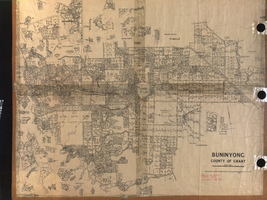
Plan, Department of Crown Lands and Survey, Melbourne, Buninyong County of Grant, 23/07/1929
... Survey, Melbourne Buninyong Scotchman's Mt Buninyong Robert Scott Clarendon Lal Lal Creek yendon warrenheip Yarowee Enfield Thomas Learmonth John Learmonth Archibald Fisken G. Schloo George Innes Peter Inglis Durham Lead J. Fry J. Forrest Parkin Lee Buninyong Recreation Reserve A parish plan of Buninyong, including Robert Scott's Mt Buninyong Pre-emptive Right, Mt Buninyong Public Park, Thomas Learmonth's land, John Learmonth's land, Scotchan's, Yendon. The Buninyong POst Office is Allotment 1. Pisition of tracks in 1859 have been marked on the plan in red. Buninyong County of Grant Plan Department of Crown ...The plan was photo-lithographed at the Departmen tof Lands and Survey, MelbourneA parish plan of Buninyong, including Robert Scott's Mt Buninyong Pre-emptive Right, Mt Buninyong Public Park, Thomas Learmonth's land, John Learmonth's land, Scotchan's, Yendon. The Buninyong POst Office is Allotment 1. Pisition of tracks in 1859 have been marked on the plan in red.buninyong, scotchman's, mt buninyong, robert scott, clarendon, lal lal creek, yendon, warrenheip, yarowee, enfield, thomas learmonth, john learmonth, archibald fisken, g. schloo, george innes, peter inglis, durham lead, j. fry, j. forrest, parkin lee, buninyong recreation reserve -
 Orbost & District Historical Society
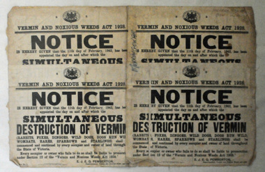
map/poster, Victorian Government Printer, 22.4.1926
... The Department of Crown Lands and Survey was originally established in 1857 as part of the Board of Land and Works. ...Orbost & District Historical Society Ruskin Street Orbost gippsland The Department of Crown Lands and Survey was originally established in 1857 as part of the Board of Land and Works. ...The Department of Crown Lands and Survey was originally established in 1857 as part of the Board of Land and Works. In 1964 it ceased to be controlled by the Board. The Department functioned for almost twenty more years before being combined with other Ministries to form the Department of Conservation, Forests and Land. It was responsible for the management of the State's Crown land and pastoral estates. This map was used by Don Mehlert after 1928. The VERMIN AND NOXIOUS WEEDS ACT 1928 was an Act to consolidate the Law relating relating to Vermin and Noxious Weeds. E. J. E. G. Pemberton who published this poster was Superintendent of Field Staff, Dept. of Lands and Survey. This map and posters are significant records of early settlement history in Murrangower, between Cabbage Tree and Orbost,A paper map of Murrangower showing settlement subdivisions. This is glued onto the back of four overlapping cloth poster of "Notices of Vermin Destruction". All print is black."DON MEHLERT" in black pen. Pike's block shaded in blue. School site marked in blue pencil. on poster "MURRANGOWAR" along side.map-murrangower poster-vermin-and-noxious-weeds murrangower-settlement -
 Orbost & District Historical Society
framed photo, APFA- Davisigns (PG & ME Davis)
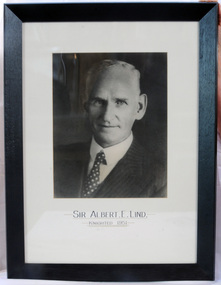
... Lind was made Minister of Forests, President of the Board of Land and Works and Commissioner of Crown Lands and Survey in Albert Dunstan's cabinet. ...Lind was made Minister of Forests, President of the Board of Land and Works and Commissioner of Crown Lands and Survey in Albert Dunstan's cabinet. ...This photo was inherited with the building when the museum was established. Lind was born in 1878 in East Charlton, Victoria, the son of Oliver Nicholas Lind, a farmer from Denmark, and his Welsh wife Mary Ann Clay. In 1882, drought forced the family to move to East Gippsland where Lind was educated at Lucknow, and then to Bairnsdale in 1884 where he attended Bairnsdale state school. In October 1920, he was elected to the Victorian Legislative Assembly for the seat of Gippsland East for the Victorian Farmers' Union. Lind was made Minister of Forests, President of the Board of Land and Works and Commissioner of Crown Lands and Survey in Albert Dunstan's cabinet. He was knighted in 1951. In 1926 two national parks east of Orbost were named the Albert and the Lind national parks after him.A framed photo of Sir Albert Eli Lind. It is a black and white head and shoulders photo in a black wooden frame.Sir Albert E. Lind Knighted !951photograph politician lind-albert government -
 Federation University Historical Collection
Documents, Appointment of New Trustees of the Ballarat School of Mines and Industries, 1894, 1894
... Crown Grant and of every other power enabling him doth hereby appoint the Said Right Reverend Samuel Thornton to be a trustee of the land in place of the said Rivett Henry Bland and James Millhinch Bickett to the addition trustees. .. . A deed appointing the Reverend Samuel Thornton as a trustee of the Ballarat School of Mines, after the death of former Trustee Rivett Henry Bland, and increasing the number of trustees by appointing James Millhinch Bickett. It includes a covering letter of Department of Lands and Survey ...A deed appointing the Reverend Samuel Thornton as a trustee of the Ballarat School of Mines, after the death of former Trustee Rivett Henry Bland, and increasing the number of trustees by appointing James Millhinch Bickett. It includes a covering letter of Department of Lands and Survey Letterhead... and whereas it is intended that forthwith after the execution hereof the said land and premises shall be so transferred that the same may become vested in the said Sir William John Clarke and John Warrington Rogers jointly with the said Right Reverend Samuel Thornton, Andrew Anderson and James Millhinch Bickett now these prexsents witness that the said Governor as such Governor as aforesaid in exercise of the power for this purpose given to him by the said Crown Grant and of every other power enabling him doth hereby appoint the Said Right Reverend Samuel Thornton to be a trustee of the land in place of the said Rivett Henry Bland and James Millhinch Bickett to the addition trustees. .. .department of lands and survey, letterhead, legal, john adrian louis earl of hopetoun, william john clarke, rivett henry bland, john warrington rogers, trustees, ballarat school of mines, ballarat school of mines trustees -
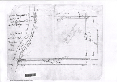
 Eltham District Historical Society Inc
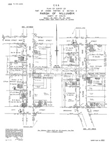
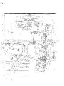
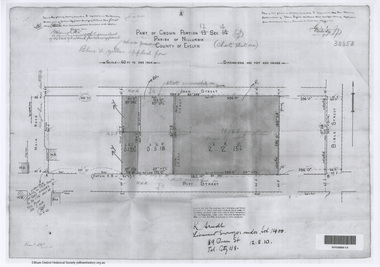
Document - Survey Plan, Country Roads Board, SP 6801, Eltham-Yarra Glen Road; Brougham St to Bridge St, 1958
... Plan of Survey of Part of Crown Portion 12 Section 4 Parish of Nillumbik, County of Evelyn Eltham-Yarra Glen Road, Shire of Eltham Shows Surveyor field notes, property ownership and building type and construction. A.J. Collis A.S. & C.G.H. Fitzpatrick Board of Land ...1958 C.R.B. Plan of Survey of Part of Crown Portion 12 Section 4 Parish of Nillumbik, County of Evelyn Eltham-Yarra Glen Road, Shire of Eltham Shows Surveyor field notes, property ownership and building type and construction.a.j. collis, a.s. & c.g.h. fitzpatrick, board of land & works, bridge street, brougham steet, commonwealth bank of australia, country roads board, eltham, eltham rsl sub-branch, f.h. collis, f.m. smith, f.n. & e.j. burgoyne, franklin street, h.c. & r.e. burgoyne, j. jorgenson, j.f. & j.e. morris, j.n. & h.c. burgoyne, j.s. blow, john street, main road, p.e. smith, pitt street, r.j. dripps, s.j. taylor, survey plan, trustees of the eltham methodist church, 1958, eltham-yarra glen road, neil webster collection -
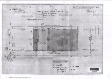
 Eltham District Historical Society Inc
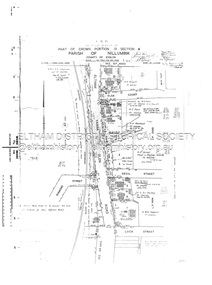
Document - Survey Plan, Country Roads Board, SP 6313, Eltham-Yarra Glen Road; Luck St to Henry St, 1956
... Plan of Survey of Part of Crown Portion 13 Section 4 Parish of Nillumbik, County of Evelyn Eltham-Yarra Glen Road, Shire of Eltham Shows Surveyor field notes, property ownership and building type and construction. Eltham-Yarra Glen Road Country Roads Board Eltham Main Road Survey Plan 1956 A.L. Lyon A.W. Brinkkotter Arthur Street C.R. Burkett Dudley Street E.N. Staff eltham war memorial trust henry street Luck Street Pryor Street The Board of Land ...1956 C.R.B. Plan of Survey of Part of Crown Portion 13 Section 4 Parish of Nillumbik, County of Evelyn Eltham-Yarra Glen Road, Shire of Eltham Shows Surveyor field notes, property ownership and building type and construction.eltham-yarra glen road, country roads board, eltham, main road, survey plan, 1956, a.l. lyon, a.w. brinkkotter, arthur street, c.r. burkett, dudley street, e.n. staff, eltham war memorial trust, henry street, luck street, pryor street, the board of land & works, the equity trustees executors and agency coy ltd, the roman catholic trusts corporation, victorian railways commision, neil webster collection -
 Eltham District Historical Society Inc
Document - Survey Plan, Country Roads Board, SP 6559-6560, Eltham-Yarra Glen Road; Elsa Ct to Luck St, 1957
... Survey of Part of Crown Portion 13 Section 4 and Crown Allotment 1 Section 1 Parish of Nillumbik, County of Evelyn Eltham-Yarra Glen Road, Shire of Eltham Shows Surveyor field notes, property ownership and building type and construction. Eltham-Yarra Glen Road Country Roads Board Eltham Main Road Survey Plan 1957 A.M. & A.A. Iowerson A.McG. Hepburn Cecil Street Coffee Lounge Diamond Street E.G. Murrell Elsa Court H.B. Woodhead J.C. & S.I. Harding la ronde Luck Street R.M. & V.M. White R.N. Mowatt The Board of Land ...1957 C.R.B. Plan of Survey of Part of Crown Portion 13 Section 4 and Crown Allotment 1 Section 1 Parish of Nillumbik, County of Evelyn Eltham-Yarra Glen Road, Shire of Eltham Shows Surveyor field notes, property ownership and building type and construction.eltham-yarra glen road, country roads board, eltham, main road, survey plan, 1957, a.m. & a.a. iowerson, a.mcg. hepburn, cecil street, coffee lounge, diamond street, e.g. murrell, elsa court, h.b. woodhead, j.c. & s.i. harding, la ronde, luck street, r.m. & v.m. white, r.n. mowatt, the board of land & works, w.g. hains, neil webster collection -
 Eltham District Historical Society Inc
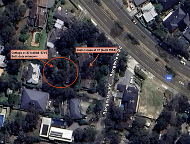
Document - Property Binder, 338 Main Road, Lower Plenty (also 37 Rangeview Road), March 2025
... Survey Field Notes of Part of Crown Portion 2, Parish of Nillumbik, County of Evelyn - Portion of land bounded by New Eltham Road. ...Survey Field Notes of Part of Crown Portion 2, Parish of Nillumbik, County of Evelyn - Portion of land bounded by New Eltham Road. ...EDHS_03095-338 | EDHS_08635-37 338 Main Road Lower Plenty | 37 Rangeview Road, Lower Plenty Original Mudbrick cottage and studio designed and built by Eltham artist, David Alan Newbury See also EDHS_06090 David Newbury (Artist) David Newbury was married to Clare Margaret Newbury. According to the 1954 Electoral Roll they were living at 36A Murphy Street, South Yarra however around 1953 they purchased Lots 3 and 4 of Main Road Lot Plan LP 23911 in Lower Plenty. A building permit, No. 71, was issued 8 December 1953 for a 5-room house of Vertical Board construction, cost £2,840, builder L. Williams, owner D. Newbury of 36 Murphy Cl., South Yarra. The large house was in fact mostly built of mudbrick, the construction method was only just becoming recognised as an acceptable form in the late 1940s for issuance of a building permit. The house was commenced in 1954, designed by David Newbury and built by David Newbury, Horrie Judd and others. Information from Newbury family friends suggests that a second mudbrick building was constructed in the late 1950s, early 1960s for use as an artist studio by Newbury. The building was connected directly to the water mains at the time and was made suitable for living accommodation during the period Newbury was teaching at Bendigo. Apparently he and Claire rented out the main house during their time in Bendigo and would reside in the studio when visiting Melbourne. No permit for this studio was found in the Building Permit Register, Shire of Eltham, 1949-1960. The last recorded entries in the register are dated May 1960. This would suggest that the studio was constructed post May 1960. It is believed the studio was constructed during the latter period of Newbury’s teaching post in Bendigo so possibly late 1960/1961. In 1963 the Newbury’s address in the Electoral Roll has the property recorded as 220 Main Road, Lower Plenty. Between 1967 to 1980 the Electoral Rolls record the property as 338 Main Road. Today the address is 37 Rangeview Road, Lower Plenty. Contents: 1. Extract from 1942 Shire of Eltham Rate Book. Muriel Gladys Reitsma listed as owner 2. Extract from 1984-85 Shire of Eltham Rate Book for Rangeview Road. (No mention of No. 37 so was probably still listed as 338 Main Road.) 3. Certificate of Title, Vol. 5601 Fol. 1120089 - Issued to David James Graham of Lower Plenty, Builder, Heidelberg for Lot 32 Block B on Plan of Subdivision No. 7606, part of Crown Portion Two, Parish of Nillumbik, County of Evelyn, 29 October 1929 4. Certificate of Title, Vol. 8008 Fol. 076 - Issued to David Alan Newbury of 36 Murphy Street, South Yarra, School Teacher for Lot 3 on Plan of Subdivision No. 23911, part of Crown Portion Two, Parish of Nillumbik, County of Evelyn, 29 October 1953. Amended 24 June 1963 to transfer portion for road widening scheme per Country Roads Board Plan 6889 - Cancelled 24 September 1984 5. Certificate of Title, Vol. 9581 Fol. 583 - Issued to Paul Robert Biber and Althea Constance Biber of 139 Lower Heidelberg Road, Ivanhoe for Lot 3 on Plan of Subdivision No. 23911, part of Crown Portion Two, Parish of Nillumbik, County of Evelyn, 24 September 1984. Derived from Vol. 8008 Fol. 076 L276994V - Cancelled 20 Nov 1992 when subdivided from one to two lots in Vol 10092 Fol. 192 and Vol. 10092 Fol. 193; LP222467B 6. Certificate of Title, Vol. 10092 Fol. 192 - Transfer to Lawrie Mein of 20 Dewar Drive, Hurstbridge of Lot 1 on Plan of Subdivision No. 222467B, lodged 17 Feb 1993, Registered 29 March 1996. Parent Titles Vol 08008 Fol 077, Vol 09581 Fol 583 7. Survey Field Notes of Part of Crown Portion 2, Parish of Nillumbik, County of Evelyn - Portion of land bounded by New Eltham Road. Application 23911 dated 8 Sep 1952 with appended Surveyor Field notes per Application 7098; R.D. Steele, Licensed Surveyor, 18 August 1950 8. Survey Field Notes of Part of Crown Portion 2, Parish of Nillumbik, County of Evelyn - Portion of land bounded by Main Road and Rangeview Road; 2 Lot subdivisions, Vol. 9581 Fol. 583 Part Lot 3 on LP 23911 and Vol. 8008 Fol, 077 Lot 4 on LP 23911; Application 221805 dated 27 November 1989; W.J. Goodison, Licensed Surveyor, and attached Surveyor's Report dated 6 June 1990 (Withdrawn) 9. Survey Field Notes of Part of Crown Portion 2, Parish of Nillumbik, County of Evelyn - Portion of land bounded by Main Road and Rangeview Road; 2 Lot subdivisions, Vol. 9581 Fol. 583 Part Lot 3 on LP 23911 and Vol. 8008 Fol, 077 Lot 4 on LP 23911; Application 222467 dated 20 November 1992 (221805 resubmitted); W.J. Goodison, Licensed Surveyor, and attached Surveyor's Report dated 6 June 1990 Notes: Items 1 to 6 donated electronically Items 7 to 9 sourced from LASSI - SPEAR, Department of Transport and Planning, Victoria State Government, https://maps.land.vic.gov.au/lassi/SpearUI.jsp main road, property, mudbrick, david newbury, phoebe mason collection, rate books, shire of eltham, certificate of title, survey plan, 37 rangeview road, 338 main road, application 23911, lower plenty, map, surveyor field notes, application 221805, application 222467 -
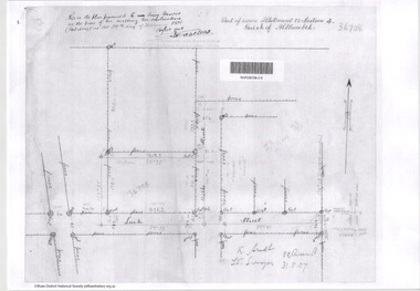
 Eltham District Historical Society Inc
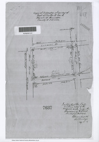
Document - Photocopy, Survey Field Notes of Part of Crown Portion 13, Section 4 at Eltham, Parish of Nillumbik, County of Evelyn, 29 May 1919
... land bounded by: Main Road, Luck Street, Bible Street, Arthur Street Application 7637 R.H. Woodcock, Licensed Surveyor, 29 May 1919 1919 Application 7637 Arthur Street Bible Street Luck Street Main Road Eltham Map Neil Webster Collection Survey Plan Surveyor Field Notes A3 printouts, 2 pages Survey Field Notes of Part of Crown Portion 13, Section 4 at Eltham, Parish of Nillumbik, County of Evelyn Document Photocopy ...Portion of land bounded by: Main Road, Luck Street, Bible Street, Arthur Street Application 7637 R.H. Woodcock, Licensed Surveyor, 29 May 19191919, application 7637, arthur street, bible street, luck street, main road eltham, map, neil webster collection, survey plan, surveyor field notes -
 Eltham District Historical Society Inc
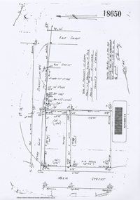
Document - Photocopy, Survey Field Notes of Part of Crown Portion 13, Section 4 at Eltham, Parish of Nillumbik, County of Evelyn, 18 October 1946
... land bounded by: Main Road, Henry Street, Bible Street Application 18650 W. Connolly, Licensed Surveyor, 18 October 1946 Map Neil Webster Collection Survey Plan Surveyor Field Notes 1946 Application 18650 Bible Street henry street Main Road Eltham Maria Street Rose Street A3 printout, 1 page Survey Field Notes of Part of Crown Portion 13, Section 4 at Eltham, Parish of Nillumbik, County of Evelyn Document Photocopy ...Portion of land bounded by: Main Road, Henry Street, Bible Street Application 18650 W. Connolly, Licensed Surveyor, 18 October 1946map, neil webster collection, survey plan, surveyor field notes, 1946, application 18650, bible street, henry street, main road eltham, maria street, rose street -
![Document - Photocopy, Survey Field Notes of Part of Crown Portion 13, Section 4 at Eltham, Parish of Nillumbik, County of Evelyn [Bourke sic], 30 September 1949](/media/collectors/4f729f7b97f83e03086018a5/items/6869da03f3688aa02254c5c2/item-media/6869da22f3688aa02254c6da/item-fit-380x285.jpg?cb=6) Eltham District Historical Society Inc
Eltham District Historical Society IncDocument - Photocopy, Survey Field Notes of Part of Crown Portion 13, Section 4 at Eltham, Parish of Nillumbik, County of Evelyn [Bourke sic], 30 September 1949
... Eltham District Historical Society Inc 728 Main Rd Eltham melbourne Portion of land bounded by: Main Road, Arthur Street, Dudley Street Application 21718 Erwin Dillon, Licensed Surveyor, 30 September 1949 Map Neil Webster Collection Survey Plan Surveyor Field Notes 1949 Application 21718 Arthur Street Dudley Street Main Road Eltham A3 printout, 1 page Survey Field Notes of Part of Crown Portion 13, Section 4 at Eltham, Parish of Nillumbik, County of Evelyn [Bourke sic] Document Photocopy ...Portion of land bounded by: Main Road, Arthur Street, Dudley Street Application 21718 Erwin Dillon, Licensed Surveyor, 30 September 1949map, neil webster collection, survey plan, surveyor field notes, 1949, application 21718, arthur street, dudley street, main road eltham -
 Eltham District Historical Society Inc
Document - Photocopy, Survey Field Notes of Part of Crown Portion 13, Section 4 at Eltham, Part of Lot 19 Subdivision of 13 Section IV (Holloways), Parish of Nillumbik, County of Evelyn, 5 May 1906
... land bounded by: Main Road, Henry Street Application 35953 A. Mackensie Tyers, Licensed Surveyor, 5 May 1906 Map Neil Webster Collection Survey Plan Surveyor Field Notes 1906 Application 33777 Application 35953 henry street Main Road Eltham Maria Street Rechabite Hall* A3 printouts, 2 pages Survey Field Notes of Part of Crown Portion 13, Section 4 at Eltham, Part of Lot 19 Subdivision of 13 Section IV (Holloways), Parish of Nillumbik, County of Evelyn Document Photocopy ...Portion of land bounded by: Main Road, Henry Street Application 35953 A. Mackensie Tyers, Licensed Surveyor, 5 May 1906map, neil webster collection, survey plan, surveyor field notes, 1906, application 33777, application 35953, henry street, main road eltham, maria street, rechabite hall* -
 Eltham District Historical Society Inc
Document - Photocopy, Survey Field Notes of Part of Crown Portion 12, Section 4 at Eltham, Parish of Nillumbik, County of Evelyn, 12 August 1910
... land bounded by: Main Road, John Street, Bible Street, Pitt Street Application 38858 K. Arndt, Licensed Surveyor, 12 August 1910 Map Neil Webster Collection Survey Plan Surveyor Field Notes 1910 Application 38858 Bible Street John Street Main Road Eltham Pitt Street A3 printout, 1 page Survey Field Notes of Part of Crown Portion 12, Section 4 at Eltham, Parish of Nillumbik, County of Evelyn Document Photocopy ...Portion of land bounded by: Main Road, John Street, Bible Street, Pitt Street Application 38858 K. Arndt, Licensed Surveyor, 12 August 1910map, neil webster collection, survey plan, surveyor field notes, 1910, application 38858, bible street, john street, main road eltham, pitt street -
 Eltham District Historical Society Inc
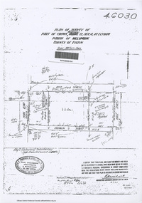
Document - Photocopy, Survey Field Notes of Part of Crown Portion 12, Section 4 at Eltham, Parish of Nillumbik, County of Evelyn, 4 July 1924
... land bounded by: Main Road, Pitt Street, Bible Street, Franklin Street Application 46030 R.H. Woodcock, Licensed Surveyor, 4 July 1924 Map Neil Webster Collection Survey Plan Surveyor Field Notes 1924 Application 46030 Bible Street Corn Store Ernie Andrew franklin street L. Grant Main Road Eltham Maria Street Peel Street Pitt Street A3 printout, 1 page Survey Field Notes of Part of Crown ...Portion of land bounded by: Main Road, Pitt Street, Bible Street, Franklin Street Application 46030 R.H. Woodcock, Licensed Surveyor, 4 July 1924map, neil webster collection, survey plan, surveyor field notes, 1924, application 46030, bible street, corn store, ernie andrew, franklin street, l. grant, main road eltham, maria street, peel street, pitt street -
 Eltham District Historical Society Inc
Document - Photocopy, Survey Fleld Notes of Part of Crown Portion 13, Section 4 at Eltham, Parish of Nillumbik, County of Evelyn, 18 May 1908
... land bounded by: Main Road, Luck Street, Bible Street, Arthur Street Application 37314 W. P. Steane, M.C.E. Civil Engineer and Surveyor, 18 May 1908 Application 37314 Arthur Street Bible Street Eltham Luck Street Main Road Map Survey Plan A4 printouts, 2 pages Survey Fleld Notes of Part of Crown Portion 13, Section 4 at Eltham, Parish of Nillumbik, County of Evelyn Document Photocopy ...Portion of land bounded by: Main Road, Luck Street, Bible Street, Arthur Street Application 37314 W. P. Steane, M.C.E. Civil Engineer and Surveyor, 18 May 1908application 37314, arthur street, bible street, eltham, luck street, main road, map, survey plan -
 Eltham District Historical Society Inc
Document - Photocopy, Survey Fleld Notes of Part of Crown Portion 13, Section 4 at Eltham, Parish of Nillumbik, County of Evelyn, 31 May 1907
... land east of Main Road and north of Luck Street bounded by Bible Street Application 36708 K. Arndt, Licensed Surveyor, 31 May 1907 Application 36708 Bible Street Eltham Luck Street Main Road Map Survey Plan A4 printouts, 2 pages Survey Fleld Notes of Part of Crown Portion 13, Section 4 at Eltham, Parish of Nillumbik, County of Evelyn Document Photocopy ...Portion of land east of Main Road and north of Luck Street bounded by Bible Street Application 36708 K. Arndt, Licensed Surveyor, 31 May 1907application 36708, bible street, eltham, luck street, main road, map, survey plan -
 Eltham District Historical Society Inc
Document - Photocopy, Survey Fleld Notes of Part of Crown Portion 13, Section 4 at Eltham, Parish of Nillumbik, County of Evelyn, November 1909
... land bounded by Main Road, Arthur Street, Bible Street, Henry Street Application 36708 K. Arndt, Licensed Surveyor, November 1909 Application 5289 Arthur Street Bible Street Eltham henry street Main Road Map Survey Plan A4 printout Survey Fleld Notes of Part of Crown Portion 13, Section 4 at Eltham, Parish of Nillumbik, County of Evelyn Document Photocopy ...Portion of land bounded by Main Road, Arthur Street, Bible Street, Henry Street Application 36708 K. Arndt, Licensed Surveyor, November 1909application 5289, arthur street, bible street, eltham, henry street, main road, map, survey plan -
 Eltham District Historical Society Inc
Document - Photocopy, Survey Fleld Notes of Part of Crown Portion 12, Section 4 at Eltham, Parish of Nillumbik, County of Evelyn, 12 October 1910
... land bounded by: Main Road, John Street, Bible Street, Pitt Street Application 38858 K. Arndt, Licensed Surveyor, 12 August 1910 Application 38858 Bible Street Eltham John Street Main Road Map Pitt Street Survey Plan A4 printouts, 2 pages Survey Fleld Notes of Part of Crown Portion 12, Section 4 at Eltham, Parish of Nillumbik, County of Evelyn Document Photocopy ...Portion of land bounded by: Main Road, John Street, Bible Street, Pitt Street Application 38858 K. Arndt, Licensed Surveyor, 12 August 1910application 38858, bible street, eltham, john street, main road, map, pitt street, survey plan -
 Eltham District Historical Society Inc
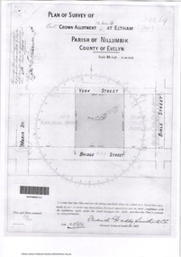
Document - Photocopy, Survey Fleld Notes of Part of Crown Portion 12, Section 4 at Eltham, Parish of Nillumbik, County of Evelyn, 20 May 1911
... land bounded by: Main Road, York Street, Bible Street, Bridge Street Application 38629 Frederick Dudley Smith, M.C.E. Licensed Surveyor, 20 May 1911 Application 38629 Bible Street Bridge Street Eltham Main Road Map Survey Plan York Street A4 printouts, 2 pages Survey Fleld Notes of Part of Crown Portion 12, Section 4 at Eltham, Parish of Nillumbik, County of Evelyn Document Photocopy ...Portion of land bounded by: Main Road, York Street, Bible Street, Bridge Street Application 38629 Frederick Dudley Smith, M.C.E. Licensed Surveyor, 20 May 1911application 38629, bible street, bridge street, eltham, main road, map, survey plan, york street