
Showing 19 items matching "damage to grounds"
-
 University of Melbourne, Burnley Campus Archives
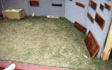
Album - Colour slides, Kodachrome, Garden Week 1985, March 1985
... damage to lawn...damage to grounds...garden week 1985 floral design displays damage to lawn damage to grounds Labelled "Garden Week 1985" Collection of 67 colour slides . ...Collection of 67 colour slides . Mar 85 M2, M4 and M7 mainly showing damage to grass, M7 mainly floral design displays.Labelled "Garden Week 1985"garden week, 1985, floral design displays, damage to lawn, damage to grounds -
![Newspaper Clipping - Digital Image, Tighter security to deter vandals [Greensborough Primary School Gr2062], 2005_](/media/collectors/4f729f5697f83e03086015b8/items/5bb9926621ea6916dc018110/item-media/5bb9928821ea6916dc01a6b8/item-fit-380x285.jpg?cb=6) Greensborough Historical Society
Greensborough Historical SocietyNewspaper Clipping - Digital Image, Tighter security to deter vandals [Greensborough Primary School Gr2062], 2005_
... Vandals entered Greensborough Primary School grounds, causing damage to buildings and 'tagging' a student mural in the playground....Vandals entered Greensborough Primary School grounds, causing damage to buildings and 'tagging' a student mural in the playground. greensborough primary school Newspaper clipping, black and white text and colour image. ...Vandals entered Greensborough Primary School grounds, causing damage to buildings and 'tagging' a student mural in the playground.Newspaper clipping, black and white text and colour image.greensborough primary school -
 City of Moorabbin Historical Society (Operating the Box Cottage Museum)
Newsletter, City of Moorabbin Historical Society Feb 2010 pdf, February 2010
... Water flooded Joyce Park, the grounds of the Cottage and a little seeped into Grace Lewis Room in December 2009 when a water main at the neighbouring Bowling Club burst, but little damage occurred and the Glen Eira Council will install drainage pipes between Box Cottage and the Bowling Club. ...Water flooded Joyce Park, the grounds of the Cottage and a little seeped into Grace Lewis Room in December 2009 when a water main at the neighbouring Bowling Club burst, but little damage occurred and the Glen Eira Council will install drainage pipes between Box Cottage and the Bowling Club. ...The City of Moorabbin Historical Society was formed c 1960 by a group of Moorabbin residents who were concerned that the history of the area should be preserved. A good response to a call for items related to the historical area of Moorabbin Shire brought donations of a wide variety of artefacts which are now preserved by the current members of CMHS at Box Cottage Museum . Helen Stanley, Secretary of CMHS, began producing a Newsletter for members in April 2007 to provide current information and well researched items of historical interestHelen Stanley has produced a bi-monthly Newsletter, 2007 - 2013, for the members of the City of Moorabbin Historical Society that contains well researched interesting historical items, notification of upcoming events, current advice from Royal Australian Historical Society , Museums Australia Victoria and activities of Local Historical Societies. The Newsletter is an important record of the activities of the CMHS5 x A4 paper printed on 1 side Issue 15 of the bi-monthly, City of Moorabbin Historical Society Newsletter produced by Society member and Secretary, Mrs Helen Stanley in February 2010. Notices for the meeting February 28th , subscriptions due, and this is 50th Anniversary of CMHS. Water flooded Joyce Park, the grounds of the Cottage and a little seeped into Grace Lewis Room in December 2009 when a water main at the neighbouring Bowling Club burst, but little damage occurred and the Glen Eira Council will install drainage pipes between Box Cottage and the Bowling Club. In January, 2 brush tailed possums had taken up residence in the Barn and after failed attempts by Helen and Dennis to move them, Glen Eira Council relocated them. A description of the establishment of Cobb & Co Coaches by Freeman Cobb in 1853, for cartage between Melbourne and the Ports but they soon began transporting people and mail to the gold fields around Victoria. 3 photocopied photographs of Cobb & Co Coaches and 1 photo of the 2 Possums CITY of MOORABBIN HISTORICAL SOCIETY / February 2010 NEWSLETTER city of moorabbin historical society, stanley helen, maynard dennis, melbourne, moorabbin, cheltenham, ormond, bentleigh, market gardeners, pioneers, early settlers, moorabbin shire, box cottage museum, lewis grace, cobb freeman, cobb and co coaches, ballarat, goldfields, gold miners, bendigo, castlemaine, governor latrobe, victoria, sydney road, sutherland alexander, chinese gold miners -
 Ringwood and District Historical Society
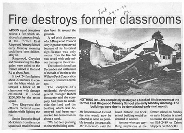
Newspaper, Ringwood East Primary School - Newspaper Clipping - 29 June 1994 - "Fire destroys former classrooms"
... damage. Detectives, including Senior Detective Boyd McKittrick, believe the blaze was deliberately lit, noting several smaller fires around the grounds. ...damage. Detectives, including Senior Detective Boyd McKittrick, believe the blaze was deliberately lit, noting several smaller fires around the grounds. ...Summary: A fire destroyed a block of 10 former classrooms at the old East Ringwood Primary School site around 3 a.m., causing about $200,000 in damage. Detectives, including Senior Detective Boyd McKittrick, believe the blaze was deliberately lit, noting several smaller fires around the grounds. Two Ringwood firefighters received minor injuries while containing the blaze. The site had been sold just a week earlier to Wilbow Peck Corporation, whose general manager Robert Boscarato said the damaged building was already scheduled for demolition and the area would now be cleared for safety. A nearby historic red‑brick classroom was saved with only minor damage. Authorities urged anyone with information to contact the arson squad or Crime Stoppers. (Co-Pilot 4/7/2026)Photo Caption: "NOTHING LEFT: fire completely destroyed a block of 10 classrooms at the former East Ringwood Primary School site early Monday morning. The buildings were due to be demolished early next month" -
 Ararat & District Historical Society (operating the Langi Morgala Museum)
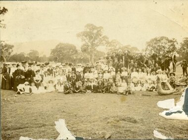
Photograph, Maker not known, 1904
... Grounds in 1904. The photo provides information about leisure wear and leisure activities in the Ararat area at this time. This photo is of local significance (Langi Ghiran and the Ararat district). Although the photo is physically damaged ...This is a photo of a very large group of people at the Langi Ghiran Picnic Grounds in 1904. The photo provides information about leisure wear and leisure activities in the Ararat area at this time. This photo is of local significance (Langi Ghiran and the Ararat district). Although the photo is physically damaged, the detail in most of the photo is still very clear, giving information on clothing and leisure activities. The fact that the date and the donor are known adds to its significance.Black and white photograph mounted on cardboard of a formal group of approximately 110 men, women and children gathered in a rural setting, standing and seated, with trees in the background. The photograph is torn away in several places"Picnic Grounds / Langi Gherin1904".clothing, leisure, 1904, picnic, leisure-activities, picnickers, photograph, langi morgala, ararat, langi ghiran -
 Sunshine and District Historical Society Incorporated
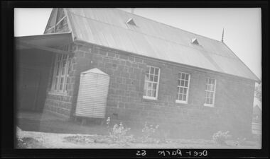
Photograph - Deer Park State School Photographs
... The old 1943–44 red‑brick main building (rebuilt after the 1942 fire), the blue stone remnants and the school grounds are now protected under Brimbank’s Heritage Overlay (HO84). These photographs capture the original blue stone school building, the damaged caused by the 1942 fire and the 1943–44 replacement red‑brick main building. ...Deer Park State School began in 1874 as State School 1434 Braybrook but soon the school became known as the Derrimut on Kororoit Creek State School. This was soon shortened to Kororoit State School The Kororoit State School and was renamed to the Deer Park State School in 1890 when the local area's name was changed from Kororoit Creek to Deer Park. The school suffered several dramatic events due to its proximity to the ICI explosives factory. These events included the windows being blown out after lightning struck the ICI factory, the ceiling collapsed after an explosion at the ICI factory, and a fire destroyed the school in 1942. The 1940's rebuild of the school included a new red brick building with bluestone detailed used from the original building. The new building matched Percy Everett’s Education Department architectural style of the era. This school was relocated to Cairnlea in 2007 and became known as the Cairnlea Park Primary School. The old 1943–44 red‑brick main building (rebuilt after the 1942 fire), the blue stone remnants and the school grounds are now protected under Brimbank’s Heritage Overlay (HO84).These photographs capture the original blue stone school building, the damaged caused by the 1942 fire and the 1943–44 replacement red‑brick main building.5343.01 - Deer Park State School Photo 01.jpg 5343.02 - Deer Park State School Photo 02.jpg 5343.03 - Deer Park State School 1942 Fire Photo 03.jpg 5343.04 - Deer Park State School 1942 Fire Photo 04.jpg 5343.05 - Deer Park State School 1942 Fire Photo 05.jpg 5343.06 - Deer Park State School 1942 Fire Photo 06.jpg 5343.07 - Deer Park State School Photo 07.jpg 5343.08 - Deer Park State School Photo 08.jpg 5343.09 - Deer Park State School Photo 09.jpg 5343.10 - Deer Park State School Photo 10.jpg 5343.11 - Deer Park State School Photo 11.jpg 5343.12 - Deer Park State School Photo 12.jpg 5343.13 - Deer Park State School Photo 13.jpg 5343.14 - Deer Park State School Photo 14.jpg 5343.15 - Deer Park State School Photo 15.jpg 5343.16 - Deer Park State School Photo 16.jpgdeer park state school, ballarat road, deer park, hume and hovell cairn -
 University of Melbourne, Burnley Campus Archives
Newspaper - Newspaper Cutting, The Age, Horticultural Society, 1865
... floods gardens annual general meeting horticultural society of victoria flood damage ornamental garden used for fruit trees additional grant of land Copy of article in "The Age" 20 July, 1865 p7. Description of Annual General Meeting. Grounds ...Copy of article in "The Age" 20 July, 1865 p7. Description of Annual General Meeting. Grounds unfit for purpose after 1863 flood. Young stock being planted in part of Ornamental Garden. Government allowing Society to select more suitable ground near to present garden.floods, gardens, annual general meeting, horticultural society of victoria, flood damage, ornamental garden used for fruit trees, additional grant of land -
 Bacchus Marsh & District Historical Society
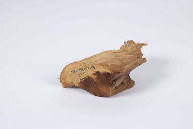
Unknown, Bell Tree Fragment
... grounds in the 1860s. It was one of the first trees planted in the school ground in Lerderderg Street. For many years the school bell was hung from this tree. This practiced ceased about 1969 and some years later the tree had to be removed as it had become damaged. ...grounds in the 1860s. It was one of the first trees planted in the school ground in Lerderderg Street. For many years the school bell was hung from this tree. This practiced ceased about 1969 and some years later the tree had to be removed as it had become damaged. ...This wood fragment comes from a red gum tree which was planted in the Bacchus Marsh Primary School grounds in the 1860s. It was one of the first trees planted in the school ground in Lerderderg Street. For many years the school bell was hung from this tree. This practiced ceased about 1969 and some years later the tree had to be removed as it had become damaged. This wood fragment was saved from the 'bell tree' when this was done. The wood fragment is an indicator of a once common, but now generally non-existent school practice of the ringing of a bell to communicate school commencement and finishing times during the school day. It has particular significance because Bacchus Marsh Primary School was the first government funded public primary school in Victoria.Red Gum tree wood fragmentschools, bacchus marsh primary school -
 Kew Historical Society Inc
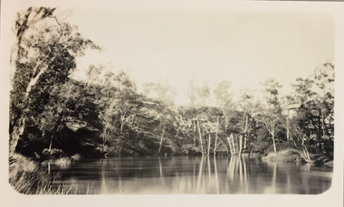
Photograph - Demolishing the Zig-Zag Bridge, 1929
... grounds of the Yarra Bend and Kew Asylums. The wooden bridge was constructed in the 1870s and lasted through numerous floods until its destruction in 1929. A horizontal structure, the walkway was reached via a wooden staircase on the Kew bank of the river. The steps were required due to the different levels of the banks on this stretch of the river. This is a photo of the bridge showing the level of destruction caused by the initial damage...grounds of the Yarra Bend and Kew Asylums. The wooden bridge was constructed in the 1870s and lasted through numerous floods until its destruction in 1929. A horizontal structure, the walkway was reached via a wooden staircase on the Kew bank of the river. The steps were required due to the different levels of the banks on this stretch of the river. This is a photo of the bridge showing the level of destruction caused by the initial damage ...Henry Beater Christian (1886-1962) , was a descendant of one of the earliest settler families in Kew. Employed at the Kew Asylum as a 'public servant', he was a skilled amateur photographer, photographing numerous scenes in Kew and on his travels around Victoria. The majority of his photographs date from 1916 to 1929. His finest photographs are housed in two photograph albums. Rare photograph of the demolition of the Zig-Zag Bridge linking the two asylums on either side of the Yarra River.Digital copy of a photograph from page 16 of the 47-page photograph album containing 261 gelatinous silver images, loaned by Diane Washfold with permission given to digitise and hold a copy in our collection. The Zig-Zag Bridge linked the grounds of the Yarra Bend and Kew Asylums. The wooden bridge was constructed in the 1870s and lasted through numerous floods until its destruction in 1929. A horizontal structure, the walkway was reached via a wooden staircase on the Kew bank of the river. The steps were required due to the different levels of the banks on this stretch of the river. This is a photo of the bridge showing the level of destruction caused by the initial damage from the flood and subsequent dismantling of the horizontal struts and walkway, prior to to its destruction by fire."Demolishing Zig-Zag / 6. 1929"henry beater christian (1886-1962), landscape photography, kew (vic.) — yarra river, christian-washfold collection, photograph albums, zig-zag bridge -
 Kew Historical Society Inc
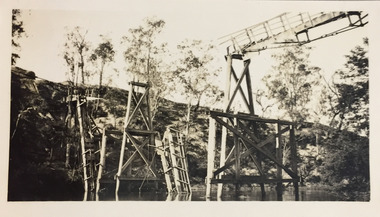
Photograph - Demolishing the Zig-Zag Bridge, 1929
... grounds of the Yarra Bend and Kew Asylums. The wooden bridge was constructed in the 1870s and lasted through numerous floods until its destruction in 1929. A horizontal structure, the walkway was reached via a wooden staircase on the Kew bank of the river. The steps were required due to the different levels of the banks on this stretch of the river. This is a closeup view of the bridge showing the level of destruction caused by the initial damage...grounds of the Yarra Bend and Kew Asylums. The wooden bridge was constructed in the 1870s and lasted through numerous floods until its destruction in 1929. A horizontal structure, the walkway was reached via a wooden staircase on the Kew bank of the river. The steps were required due to the different levels of the banks on this stretch of the river. This is a closeup view of the bridge showing the level of destruction caused by the initial damage ...Henry Beater Christian (1886-1962) , was a descendant of one of the earliest settler families in Kew. Employed at the Kew Asylum as a 'public servant', he was a skilled amateur photographer, photographing numerous scenes in Kew and on his travels around Victoria. The majority of his photographs date from 1916 to 1929. His finest photographs are housed in two photograph albums. Rare photograph of the demolition of the Zig-Zag Bridge linking the two asylums on either side of the Yarra River.Digital copy of a photograph from page 16 of the 47-page photograph album containing 261 gelatinous silver images, loaned by Diane Washfold with permission given to digitise and hold a copy in our collection. The Zig-Zag Bridge linked the grounds of the Yarra Bend and Kew Asylums. The wooden bridge was constructed in the 1870s and lasted through numerous floods until its destruction in 1929. A horizontal structure, the walkway was reached via a wooden staircase on the Kew bank of the river. The steps were required due to the different levels of the banks on this stretch of the river. This is a closeup view of the bridge showing the level of destruction caused by the initial damage from the flood and subsequent dismantling of the horizontal struts and walkway, prior to to its destruction by fire."Demolishing Zig-Zag / 6. 1929"henry beater christian (1886-1962), landscape photography, kew (vic.) — yarra river, christian-washfold collection, photograph albums, zig-zag bridge -
 Kew Historical Society Inc
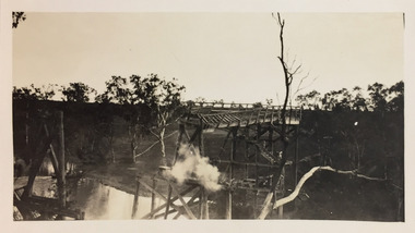
Photograph - Demolishing the Zig-Zag Bridge, 1929
... grounds of the Yarra Bend and Kew Asylums. The wooden bridge was constructed in the 1870s and lasted through numerous floods until its destruction in 1929. A horizontal structure, the walkway was reached via a wooden staircase on the Kew bank of the river. The steps were required due to the different levels of the banks on this stretch of the river. This is a view of the bridge showing the level of destruction caused by the initial damage...grounds of the Yarra Bend and Kew Asylums. The wooden bridge was constructed in the 1870s and lasted through numerous floods until its destruction in 1929. A horizontal structure, the walkway was reached via a wooden staircase on the Kew bank of the river. The steps were required due to the different levels of the banks on this stretch of the river. This is a view of the bridge showing the level of destruction caused by the initial damage ...Henry Beater Christian (1886-1962) , was a descendant of one of the earliest settler families in Kew. Employed at the Kew Asylum as a 'public servant', he was a skilled amateur photographer, photographing numerous scenes in Kew and on his travels around Victoria. The majority of his photographs date from 1916 to 1929. His finest photographs are housed in two photograph albums. Rare photograph of the demolition of the Zig-Zag Bridge linking the two asylums on either side of the Yarra River.Digital copy of a photograph from page 16 of the 47-page photograph album containing 261 gelatinous silver images, loaned by Diane Washfold with permission given to digitise and hold a copy in our collection. The Zig-Zag Bridge linked the grounds of the Yarra Bend and Kew Asylums. The wooden bridge was constructed in the 1870s and lasted through numerous floods until its destruction in 1929. A horizontal structure, the walkway was reached via a wooden staircase on the Kew bank of the river. The steps were required due to the different levels of the banks on this stretch of the river. This is a view of the bridge showing the level of destruction caused by the initial damage from the flood, the subsequent dismantling of the horizontal struts and walkway, and the setting on fire of the remaining structure."Demolishing Zig-Zag / 6. 1929"henry beater christian (1886-1962), landscape photography, kew (vic.) — yarra river, christian-washfold collection, photograph albums, zig-zag bridge -
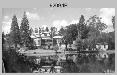 Bendigo Military Museum
Photograph - LHQ Cartographic Company Personnel and Vehicles, Fortuna, Bendigo, 1943 to 1945
... damage of air attack, to investigate suitable safer inland accommodation for LHQ Cartographic Company. Major William Sarll inspected many properties before finding one that would meet the requirements of the Cartographic Company. In late 1941, he came to inspect Fortuna, a rambling old mansion dating back to the gold rush, with about fifteen acres of ground in central Bendigo. On 23 March 1942, the Commonwealth of Australia, under the provisions of the National Security Act of 1939, took possession of the house, the old battery buildings and the fifteen acres of grounds...damage of air attack, to investigate suitable safer inland accommodation for LHQ Cartographic Company. Major William Sarll inspected many properties before finding one that would meet the requirements of the Cartographic Company. In late 1941, he came to inspect Fortuna, a rambling old mansion dating back to the gold rush, with about fifteen acres of ground in central Bendigo. On 23 March 1942, the Commonwealth of Australia, under the provisions of the National Security Act of 1939, took possession of the house, the old battery buildings and the fifteen acres of grounds ...This is a set of 12 photographs taken in 1943 and 1945, during Army’s early years of occupation at Fortuna, Bendigo in WW2. The black and white photographs are contained in a photo album provided by the family of Rosemary (Atkinson) Bowman, who served in the Australian Women's Army Service (AWAS) and a former member of RA Svy. On 1 Feb 1941, a Cartographic Section was reformed as the Land Headquarters (LHQ) Cartographic Company. Deputy Chief of the General Staff, Major General Sidney Rowell instructed Its OC - Major William Sarll, in the interests of security of plant and to provide against possible damage of air attack, to investigate suitable safer inland accommodation for LHQ Cartographic Company. Major William Sarll inspected many properties before finding one that would meet the requirements of the Cartographic Company. In late 1941, he came to inspect Fortuna, a rambling old mansion dating back to the gold rush, with about fifteen acres of ground in central Bendigo. On 23 March 1942, the Commonwealth of Australia, under the provisions of the National Security Act of 1939, took possession of the house, the old battery buildings and the fifteen acres of grounds. LHQ Cartographic Company moved to Bendigo on 11 Jun 1942, from Mitchell House, Melbourne. The responsibilities of this unit were map compilation, fair drawing and lithographic reproduction, including printing the work of other Units as well as their own. A decision of War Cabinet on 13 August 1941 had authorised the formation of the Australian Women's Army Service (AWAS), in order to release men from certain military duties for employment with fighting units. Originally their employment was restricted to traditional female areas and numbers were strictly limited, but the outbreak of the Pacific War in 1942 led to a broadening of employment categories and an increase in numbers. The first AWAS arrived at Fortuna on 26 November 1942 and immediately became an integral part of the unit. Most of these women had artistic talent. Their work included fine drawing work, filling in all the topographical detail on fair copies of field sheets and pasting on names and figures, while others were drawing actual map outlines. Other sections the AWAS worked in were the duffing section, where unwanted features were painted out of the negatives before reproduction, and the retouching section where any defects in the zinc plates were corrected. The AWAS also worked on creating Army posters and other publicity material in this section. Seventy-five AWAS served with the Cartographic Company during the war. Refer to Item 6099.17P for photos taken in 1942, the first year of LHQ Cartographic Company’s occupation at Fortuna, Bendigo in WW2. The Survey Corps’ occupation of Fortuna during WW2 is covered in more detail with additional historic photographs, in pages 17 to 27 of Valerie Lovejoy’s book 'Mapmakers of Fortuna – A history of the Army Survey Regiment’ ISBN: 0-646-42120-4. Other items from Rosemary (Atkinson) Bowman are: 9210.16P, 99211.6P, 9212.6P, 9213.4P and 9214.12 This is a set of 12 photographs taken in 1943 and 1945, during Army’s early years of occupation at Fortuna, Bendigo in WW2. The black and white photographs are printed on photographic paper are contained in a photo album provided by the family of Rosemary (Atkinson) Bowman, who served in the Australian Women's Army Service (AWAS) and a former member of RA Svy. The photographs were scanned at 600 dpi and are part of the Army Survey Regiment’s Collection. .1) - Photo, black & white, 1943. LHQ Cartographic Company, Fortuna Villa, Bendigo. .2) - Photo, black & white, 1943. Ronye Bond. .3) - Photo, black & white, 1943. Rosemary (Atkinson) Bowman. .4) - Photo, black & white, 1943. Billie Hyatt. .5) - Photo, black & white, 1943. Helen Morton. .6) - Photo, black & white, 1943. Wes Runting. .7) - Photo, black & white, 1943. Ronye Bond. .8) - Photo, black & white, 1943. Rosemary (Atkinson) Bowman. .9) - Photo, black & white, 1943. Accommodation Tents L to R: Norma Lewis, Billie Hyatt, Peggy Priest, Ken Taylor, Tiny Lewis, Norma Jeffrey. .10) - Photo, black & white, 1943. Marching Contest in Bendigo’s Charing Cross. .11) - Photo, black & white, 1945. In front of Regimental Office. .12) - Photo, black & white, 1945. Part of Drive.Some personnel are identified with dates in the photo album.royal australian survey corps, rasvy, army survey regiment, asr, fortuna -
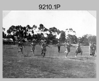 Bendigo Military Museum
Photograph - LHQ Cartographic Company Inter-Section Sports Meeting, Upper Reserve, Bendigo, 1943
... damage of air attack, to investigate suitable safer inland accommodation for LHQ Cartographic Company. Major William Sarll inspected many properties before finding one that would meet the requirements of the Cartographic Company. In late 1941, he came to inspect Fortuna, a rambling old mansion dating back to the gold rush, with about fifteen acres of ground in central Bendigo. On 23 March 1942, the Commonwealth of Australia, under the provisions of the National Security Act of 1939, took possession of the house, the old battery buildings and the fifteen acres of grounds...damage of air attack, to investigate suitable safer inland accommodation for LHQ Cartographic Company. Major William Sarll inspected many properties before finding one that would meet the requirements of the Cartographic Company. In late 1941, he came to inspect Fortuna, a rambling old mansion dating back to the gold rush, with about fifteen acres of ground in central Bendigo. On 23 March 1942, the Commonwealth of Australia, under the provisions of the National Security Act of 1939, took possession of the house, the old battery buildings and the fifteen acres of grounds ...This is a set of 16 photographs of an LHQ Cartographic Company inter-section sports meeting taken in 1943 at Bendigo’s Upper Reserve, during Army’s early years of occupation at Fortuna, Bendigo in WW2. Bendigo’s Upper Reserve was renamed the Queen Elizabeth Oval in 1954 in honour of Queen Elizabeth II. On 1 Feb 1941, a Cartographic Section was reformed as the Land Headquarters (LHQ) Cartographic Company. Deputy Chief of the General Staff, Major General Sidney Rowell instructed Its OC - Major William Sarll, in the interests of security of plant and to provide against possible damage of air attack, to investigate suitable safer inland accommodation for LHQ Cartographic Company. Major William Sarll inspected many properties before finding one that would meet the requirements of the Cartographic Company. In late 1941, he came to inspect Fortuna, a rambling old mansion dating back to the gold rush, with about fifteen acres of ground in central Bendigo. On 23 March 1942, the Commonwealth of Australia, under the provisions of the National Security Act of 1939, took possession of the house, the old battery buildings and the fifteen acres of grounds. LHQ Cartographic Company moved to Bendigo on 11 Jun 1942, from Mitchell House, Melbourne. The responsibilities of this unit were map compilation, fair drawing and lithographic reproduction, including printing the work of other Units as well as their own. A variety of sporting activities were part of the leisure hours of company members. As well as the regular Wednesday afternoon of organised sport, the printing sections in particular played vigorous informal games of volleyball in every break. Others played tennis on the dilapidated tennis courts or the Ironbark courts, while the lake was an attraction for swimmers with its diving board and raft. Highlights of the sporting year were the athletics sports meetings organised by Lieutenant Ralph Westgarth and a keen committee in 1943 and 1944. These were social as well as competitive occasions, providing great entertainment for the participants and their families, and combined with fundraising for local charities. Events ranged from traditional track and field where Phil Flood proved himself an outstanding athlete, to sack races, tunnel ball and obstacle races. Recreational and sporting activities were often hampered by shift routines, but the focus given to them in all Company publications demonstrates their important role in boosting morale. Both working and playing together meant that planned diversions were essential for fitness and relaxation. The importance of sport in building esprit de corps was understood, and in fact continued to be an important facet of regimental life long after the war was over. Refer to Item 6099.17P for photos taken in 1942, the first year of LHQ Cartographic Company’s occupation at Fortuna, Bendigo in WW2. The Survey Corps’ occupation of Fortuna during WW2 is covered in more detail with additional historic photographs, in pages 17 to 27 of Valerie Lovejoy’s book 'Mapmakers of Fortuna – A history of the Army Survey Regiment’ ISBN: 0-646-42120-4. Other items from Rosemary (Atkinson) Bowman are: 9209.16P, 9211.6P, 9212.6P, 9213.4P and 9214.12.This is a set of 16 photographs of an LHQ Cartographic Company inter-section sports meeting taken in 1943 at Bendigo’s Upper Reserve, during Army’s early years of occupation at Fortuna, Bendigo in WW2. The black and white photographs are printed on photographic paper are contained in a photo album provided by the family of Rosemary (Atkinson) Bowman, who served in the Australian Women's Army Service (AWAS) and a former member of RA Svy. The photographs were scanned at 600 dpi and are part of the Army Survey Regiment’s Collection. .1) - Photo, black & white, 1943. First Heat 50 Yards Skipping L to R: O. Keddie, G. John, M. Keddie, Rosemary (Atkinson) Bowman, M. Mays. .2) - Photo, black & white, 1943. 50 Yards Skipping Final. .3) - Photo, black & white, 1943. Sack Race - AWAS .4) - Photo, black & white, 1943. Tunnel Ball - AWAS vs Men over Thirty. .5) - Photo, black & white, 1943. First Heat - AWAS Nomination Race. .6) - Photo, black & white, 1943. Final - AWAS Nomination Race. .7) - Photo, black & white, 1943. Inter Section Flag Race. .8) - Photo, black & white, 1943. Second Heat Mens 100 Yards – Winner H. Fallu. .9) - Photo, black & white, 1943. 220 Yards – Winner D. Sutcliffe. .10) - Photo, black & white, 1943. Tug of War – WO’s & SGTs Team. .11) - Photo, black & white, 1943. Long Jump Winner – P. Flood. .12) - Photo, black & white, 1943. High Jump Winner – P. Flood. .13) - Photo, black & white, 1943. Referee – CAPT Harry Raisbeck. .14) - Photo, black & white, 1943. At the mike – L to R: LT Ralph Westgarth, “PAG” and Gordon Furneaux in background. .15) - Photo, black & white, 1943. At the mike – L to R: J. Elliott, Gordon Furneaux, Eddie Esposito, Les Anderson, “Westy”, Ralph Pickford. .16) - Photo, black & white, 1943. Spectators – L to R: Betty Pleydell, Joan Ashton, Val Edwards, Norma Jeffrey, Rosemary (Atkinson) Bowman, Gwen John, Gwennie McGown, Joan Walters.Some personnel are identified with dates in the photo album.royal australian survey corps, rasvy, army survey regiment, asr, fortuna -
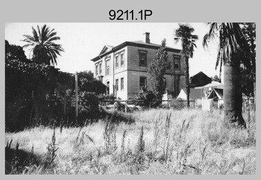 Bendigo Military Museum
Photograph - LHQ Cartographic Company AWAS Accommodation, Westend Hall, Bendigo, 1943
... damage of air attack, to investigate suitable safer inland accommodation for LHQ Cartographic Company. Major William Sarll inspected many properties before finding one that would meet the requirements of the Cartographic Company. In late 1941, he came to inspect Fortuna, a rambling old mansion dating back to the gold rush, with about fifteen acres of ground in central Bendigo. On 23 March 1942, the Commonwealth of Australia, under the provisions of the National Security Act of 1939, took possession of the house, the old battery buildings and the fifteen acres of grounds...damage of air attack, to investigate suitable safer inland accommodation for LHQ Cartographic Company. Major William Sarll inspected many properties before finding one that would meet the requirements of the Cartographic Company. In late 1941, he came to inspect Fortuna, a rambling old mansion dating back to the gold rush, with about fifteen acres of ground in central Bendigo. On 23 March 1942, the Commonwealth of Australia, under the provisions of the National Security Act of 1939, took possession of the house, the old battery buildings and the fifteen acres of grounds ...This is a set of 12 photographs taken during Army’s occupation at Fortuna, Bendigo in WW2. On 1 Feb 1941, a Cartographic Section was reformed as the Land Headquarters (LHQ) Cartographic Company. Deputy Chief of the General Staff, Major General Sidney Rowell instructed Its OC - Major William Sarll, in the interests of security of plant and to provide against possible damage of air attack, to investigate suitable safer inland accommodation for LHQ Cartographic Company. Major William Sarll inspected many properties before finding one that would meet the requirements of the Cartographic Company. In late 1941, he came to inspect Fortuna, a rambling old mansion dating back to the gold rush, with about fifteen acres of ground in central Bendigo. On 23 March 1942, the Commonwealth of Australia, under the provisions of the National Security Act of 1939, took possession of the house, the old battery buildings and the fifteen acres of grounds. LHQ Cartographic Company moved to Bendigo on 11 Jun 1942, from Mitchell House, Melbourne. The responsibilities of this unit were map compilation, fair drawing and lithographic reproduction, including printing the work of other Units as well as their own. A decision of War Cabinet on 13 August 1941 had authorised the formation of the Australian Women's Army Service (AWAS), in order to release men from certain military duties for employment with fighting units. Originally their employment was restricted to traditional female areas and numbers were strictly limited, but the outbreak of the Pacific War in 1942 led to a broadening of employment categories and an increase in numbers. The first AWAS arrived at Fortuna on 26 November 1942 and immediately became an integral part of the unit. Seventy-five AWAS served with the Cartographic Company during the war and Major Sarll paid them a special tribute for their 'untiring efforts' in the Company's war report. The AWAS could not be accommodated at Fortuna, and a nearby house, Westend Hall, on the corner of Lily and Barnard Streets, provided the first barracks with Warrant Officer Durack in charge. The building, designed by Vahland and Getzchmann in 1868, has been described as the 'grandest house on the goldfields with elegant Corinthian columns supporting a balustraded portico.' The building was conveniently situated close to the front gates of Fortuna. The women appreciated their pleasant surroundings as a magazine article written a year after their arrival reveals. 'It was a stroke of luck which gave us West End Hall with its gardens and large airy rooms; and it is to Miss Durack that we must give thanks for the bright furnishings, the good food and ... the splendid atmosphere of comradeship. But not all could be accommodated in the house; some slept in tents through the freezing Bendigo winters. Local girls like Gwen McGown were able to live at home, but had to report for the Monday morning parade after which the women would march to work. Saturday afternoon was designated sports afternoon for the women. They formed teams among themselves for competitions in basketball and softball. The women participated in an active way in the recreational activities of the Company, including athletics sports days, marching contests, concerts and dances. In the later years of the war, the barracks at West End Hall were too cramped and the AWAS were transferred to Lansellstowe, a beautiful old home in Barkly Terrace built originally for Leonard Vere Lansell, the third son of George Lansell. Prior to the AWAS occupation the Army had used the spacious house as a camp hospital. Refer to Item 6099.17P for photos taken in 1942, the first year of LHQ Cartographic Company’s occupation at Fortuna, Bendigo in WW2. The Survey Corps’ occupation of Fortuna during WW2 is covered in more detail with additional historic photographs, in pages 17 to 27 of Valerie Lovejoy’s book 'Mapmakers of Fortuna – A history of the Army Survey Regiment’ ISBN: 0-646-42120-4.Other items from Rosemary (Atkinson) Bowman are: 9209.12P, 9210.16P, 9212.6P, 9213.4P and 9214.12. This is a set of four photographs of AWAS Accommodation at ‘Westend Hall’, taken in 1943 during Army’s early years of occupation at Fortuna, Bendigo in WW2. The black and white photo, graphs are printed on photographic paper are contained in a photo album provided by the family of Rosemary (Atkinson) Bowman, a former member of RA Svy. The photographs were scanned at 600 dpi and are part of the Army Survey Regiment’s Collection. .1) - Photo, black & white, 1943. AWAS Accommodation, Westend Hall. .2) - Photo, black & white, 1943. At front steps of Westend Hall. L to R: Norma Lewis, Tiny Lewis, Billie Hyatt, Norma Jeffrey, Betty Eyval, Peggy Priest. .3) - Photo, black & white, 1943. Hall and stairway inside the old barracks - Westend Hall. .4) - Photo, black & white, 1943. Recreation room inside the old barracks - Westend Hall.Some personnel are identified with dates in the photo album.royal australian survey corps, rasvy, army survey regiment, asr, fortuna -
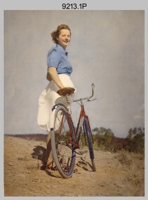 Bendigo Military Museum
Photograph - LHQ Cartographic Company Visit to Spring Gully and Castlemaine, 1943, 1944
... damage of air attack, to investigate suitable safer inland accommodation for LHQ Cartographic Company. Major William Sarll inspected many properties before finding one that would meet the requirements of the Cartographic Company. In late 1941, he came to inspect Fortuna, a rambling old mansion dating back to the gold rush, with about fifteen acres of ground in central Bendigo. On 23 March 1942, the Commonwealth of Australia, under the provisions of the National Security Act of 1939, took possession of the house, the old battery buildings and the fifteen acres of grounds...damage of air attack, to investigate suitable safer inland accommodation for LHQ Cartographic Company. Major William Sarll inspected many properties before finding one that would meet the requirements of the Cartographic Company. In late 1941, he came to inspect Fortuna, a rambling old mansion dating back to the gold rush, with about fifteen acres of ground in central Bendigo. On 23 March 1942, the Commonwealth of Australia, under the provisions of the National Security Act of 1939, took possession of the house, the old battery buildings and the fifteen acres of grounds ...This is a set of four photographs of Land Headquarters (LHQ) Cartographic Company personnel taken on Christmas Day, 25 December 1943 at Spring Gully Reservoir, Bendigo and in March 1944 during a visit to Castlemaine, 37km south of Bendigo. These visits were taken during Army’s WW2 occupation of Fortuna, Bendigo. On 1 Feb 1941, a Cartographic Section was reformed as the LHQ Cartographic Company. Deputy Chief of the General Staff, Major General Sidney Rowell instructed Its OC - Major William Sarll, in the interests of security of plant and to provide against possible damage of air attack, to investigate suitable safer inland accommodation for LHQ Cartographic Company. Major William Sarll inspected many properties before finding one that would meet the requirements of the Cartographic Company. In late 1941, he came to inspect Fortuna, a rambling old mansion dating back to the gold rush, with about fifteen acres of ground in central Bendigo. On 23 March 1942, the Commonwealth of Australia, under the provisions of the National Security Act of 1939, took possession of the house, the old battery buildings and the fifteen acres of grounds. LHQ Cartographic Company moved to Bendigo on 11 Jun 1942, from Mitchell House, Melbourne. The responsibilities of this unit were map compilation, fair drawing and lithographic reproduction, including printing the work of other Units as well as their own. Added to this unlikely mixture of permanent army officers, skilled tradesmen, artists and old soldiers were the women of the Company. A decision of War Cabinet on 13 August 1941 had authorised the formation of the Australian Women's Army Service (AWAS), in order to release men from certain military duties for employment with fighting units. Originally their employment was restricted to traditional female areas and numbers were strictly limited, but the outbreak of the Pacific War in 1942 led to a broadening of employment categories and an increase in numbers. The first AWAS arrived at Fortuna on 26 November 1942 and immediately became an integral part of the unit. Seventy-five AWAS served with the Cartographic Company during the war and Major Sarll paid them a special tribute for their 'untiring efforts' in the Company's war report. Refer to Item 6099.17P for photos taken in 1942, the first year of LHQ Cartographic Company’s occupation at Fortuna, Bendigo in WW2. The Survey Corps’ occupation of Fortuna during WW2 is covered in more detail with additional historic photographs, in pages 17 to 27 of Valerie Lovejoy’s book 'Mapmakers of Fortuna – A history of the Army Survey Regiment’ ISBN: 0-646-42120-4. Other items from Rosemary (Atkinson) Bowman are: 9209.12P, 9210.16P, 99211.6P, 9212.6P, and 9214.12.This is a set of four photographs of Land Headquarters (LHQ) Cartographic Company personnel taking time off at Spring Gully, Bendigo on December 1943 and Castlemaine in March 1944, during Army’s WW2 occupation of Fortuna, Bendigo. The colour and black and white photographs are printed on photographic paper are contained in a photo album provided by the family of Rosemary (Atkinson) Bowman, a former member of RA Svy. The photographs were scanned at 600 dpi and are part of the Army Survey Regiment’s Collection. .2) - Photo, colour, 25 December 1943. Rosemary (Atkinson) Bowman at Spring Gully Reservoir, Bendigo. .2) - Photo, black & white, March 1944. Outside Cumberland Hotel, Castlemaine, L to R: Ken Taylor, Wes Runting, Bob Vincent. .3) - Photo, black & white, March 1944. Outside Cumberland Hotel, Castlemaine, L to R: Rosemary (Atkinson) Bowman, Bob Vincent. .4) - Photo, black & white, March 1944. Halfway back to Bendigo - Rosemary (Atkinson) Bowman.Some personnel are identified with dates in the photo album.royal australian survey corps, rasvy, army survey regiment, asr, fortuna -
 Bendigo Military Museum
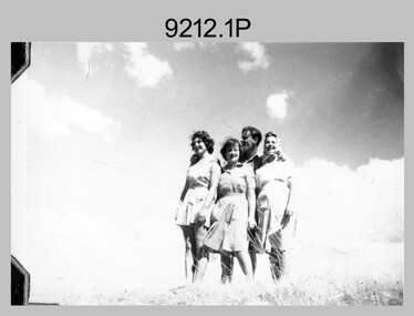
Photograph - LHQ Cartographic Company Picnic, Axe Creek, Bendigo region, 1944
... damage of air attack, to investigate suitable safer inland accommodation for LHQ Cartographic Company. Major William Sarll inspected many properties before finding one that would meet the requirements of the Cartographic Company. In late 1941, he came to inspect Fortuna, a rambling old mansion dating back to the gold rush, with about fifteen acres of ground in central Bendigo. On 23 March 1942, the Commonwealth of Australia, under the provisions of the National Security Act of 1939, took possession of the house, the old battery buildings and the fifteen acres of grounds...damage of air attack, to investigate suitable safer inland accommodation for LHQ Cartographic Company. Major William Sarll inspected many properties before finding one that would meet the requirements of the Cartographic Company. In late 1941, he came to inspect Fortuna, a rambling old mansion dating back to the gold rush, with about fifteen acres of ground in central Bendigo. On 23 March 1942, the Commonwealth of Australia, under the provisions of the National Security Act of 1939, took possession of the house, the old battery buildings and the fifteen acres of grounds ...This is a set of six photographs of Land Headquarters (LHQ) Cartographic Company personnel taken in 1944 at a picnic held at Axe Creek, a locality 15km SE of Bendigo, during Army’s WW2 occupation of Fortuna, Bendigo. On 1 Feb 1941, a Cartographic Section was reformed as the LHQ Cartographic Company. Deputy Chief of the General Staff, Major General Sidney Rowell instructed Its OC - Major William Sarll, in the interests of security of plant and to provide against possible damage of air attack, to investigate suitable safer inland accommodation for LHQ Cartographic Company. Major William Sarll inspected many properties before finding one that would meet the requirements of the Cartographic Company. In late 1941, he came to inspect Fortuna, a rambling old mansion dating back to the gold rush, with about fifteen acres of ground in central Bendigo. On 23 March 1942, the Commonwealth of Australia, under the provisions of the National Security Act of 1939, took possession of the house, the old battery buildings and the fifteen acres of grounds. LHQ Cartographic Company moved to Bendigo on 11 Jun 1942, from Mitchell House, Melbourne. The responsibilities of this unit were map compilation, fair drawing and lithographic reproduction, including printing the work of other Units as well as their own. Added to this unlikely mixture of permanent army officers, skilled tradesmen, artists and old soldiers were the women of the Company. A decision of War Cabinet on 13 August 1941 had authorised the formation of the Australian Women's Army Service (AWAS), in order to release men from certain military duties for employment with fighting units. Originally their employment was restricted to traditional female areas and numbers were strictly limited, but the outbreak of the Pacific War in 1942 led to a broadening of employment categories and an increase in numbers. The first AWAS arrived at Fortuna on 26 November 1942 and immediately became an integral part of the unit. Seventy-five AWAS served with the Cartographic Company during the war and Major Sarll paid them a special tribute for their 'untiring efforts' in the Company's war report. Refer to Item 6099.17P for photos taken in 1942, the first year of LHQ Cartographic Company’s occupation at Fortuna, Bendigo in WW2. The Survey Corps’ occupation of Fortuna during WW2 is covered in more detail with additional historic photographs, in pages 17 to 27 of Valerie Lovejoy’s book 'Mapmakers of Fortuna – A history of the Army Survey Regiment’ ISBN: 0-646-42120-4. Other items from Rosemary (Atkinson) Bowman are: 9209.12P, 9210.16P, 99211.6P, 9213.4P and 9214.12. This is a set of six photographs of Australian Survey Corps personnel at a picnic held at Axe Creek, a locality a locality 15km SE of Bendigo, taken in 1944 during Army’s WW2 occupation of Fortuna, Bendigo. in printed on photographic paper are contained in a photo album provided by the family of Rosemary (Atkinson) Bowman, a former member of RA Svy. The photographs were scanned at 600 dpi and are part of the Army Survey Regiment’s Collection. .1) - Photo, black & white, 1944. L to R: Ronye Bond, Margie, Phil Flood, Rosemary (Atkinson) Bowman. .2) - Photo, black & white, 1944. L to R: Rosemary (Atkinson) Bowman, Margie, Bob Vincent, ‘Noakie’, Wes Runting. .3) - Photo, black & white, 1944. Rosemary (Atkinson) Bowman. .4) - Photo, black & white, 1944. L to R: ‘Noakie’, Wes Runting. .5) - Photo, black & white, 1944. Back row L to R: Ronald ‘Stape’ Stapleton, Wes ‘JD’ Runting, Ray Jones, Centre row L to R: Ronye Bond, Peggy Priest, Rosemary (Atkinson) Bowman. At front: Noakie. .6) - Photo, black & white, 1944. L to R: Ray Jones, Ronye Bond, ‘Noakie’, Rosemary (Atkinson) Bowman, Wes ‘JD’ Runting, Ronald ‘Stape’ Stapleton.Some personnel are identified with dates in the photo album.royal australian survey corps, rasvy, army survey regiment, asr, fortuna -
 Bendigo Military Museum
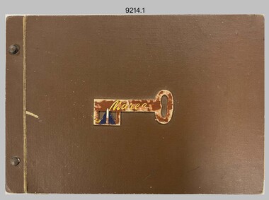
Card - LHQ Cartographic Company Publications, Fortuna, Bendigo, 1943 to 1945
... damage of air attack, to investigate suitable safer inland accommodation for LHQ Cartographic Company. Major William Sarll inspected many properties before finding one that would meet the requirements of the Cartographic Company. In late 1941, he came to inspect Fortuna, a rambling old mansion dating back to the gold rush, with about fifteen acres of ground in central Bendigo. On 23 March 1942, the Commonwealth of Australia, under the provisions of the National Security Act of 1939, took possession of the house, the old battery buildings and the fifteen acres of grounds...damage of air attack, to investigate suitable safer inland accommodation for LHQ Cartographic Company. Major William Sarll inspected many properties before finding one that would meet the requirements of the Cartographic Company. In late 1941, he came to inspect Fortuna, a rambling old mansion dating back to the gold rush, with about fifteen acres of ground in central Bendigo. On 23 March 1942, the Commonwealth of Australia, under the provisions of the National Security Act of 1939, took possession of the house, the old battery buildings and the fifteen acres of grounds ...This is a collection of publications produced from 1943 to 1945, during Army’s early years of occupation at Fortuna, Bendigo in WW2. The first item is a colour photograph of a photo album cover. The remaining items are publications printed on manilla card. The items are from a photo album provided by the family of Rosemary (Atkinson) Bowman, who served in the Australian Women's Army Service (AWAS) and a former member of RA Svy. On 1 Feb 1941, a Cartographic Section was reformed as the Land Headquarters (LHQ) Cartographic Company. Deputy Chief of the General Staff, Major General Sidney Rowell instructed Its OC - Major William Sarll, in the interests of security of plant and to provide against possible damage of air attack, to investigate suitable safer inland accommodation for LHQ Cartographic Company. Major William Sarll inspected many properties before finding one that would meet the requirements of the Cartographic Company. In late 1941, he came to inspect Fortuna, a rambling old mansion dating back to the gold rush, with about fifteen acres of ground in central Bendigo. On 23 March 1942, the Commonwealth of Australia, under the provisions of the National Security Act of 1939, took possession of the house, the old battery buildings and the fifteen acres of grounds. LHQ Cartographic Company moved to Bendigo on 11 Jun 1942, from Mitchell House, Melbourne. The responsibilities of this unit were map compilation, fair drawing and lithographic reproduction, including printing the work of other Units as well as their own. Added to this unlikely mixture of permanent army officers, skilled tradesmen, artists and old soldiers were the women of the Company. A decision of War Cabinet on 13 August 1941 had authorised the formation of the Australian Women's Army Service (AWAS), in order to release men from certain military duties for employment with fighting units. Originally their employment was restricted to traditional female areas and numbers were strictly limited, but the outbreak of the Pacific War in 1942 led to a broadening of employment categories and an increase in numbers. The first AWAS arrived at Fortuna on 26 November 1942 and immediately became an integral part of the unit. Most of these women had artistic talent. Their work included fine drawing work, filling in all the topographical detail on fair copies of field sheets and pasting on names and figures, while others were drawing actual map outlines. Other sections the AWAS worked in were the duffing section, where unwanted features were painted out of the negatives before reproduction, and the retouching section where any defects in the zinc plates were corrected. The AWAS also worked on creating Army posters and other publicity material in this section. Sometimes the women were employed in particularly arduous jobs. With Lieutenant Goodrich in charge, approximately twenty AWAS worked in the folding section where they spent long and arduous hours folding, collating and stapling top secret cipher and code publications. Seventy-five AWAS served with the Cartographic Company during the war and Major Sarll paid them a special tribute for their 'untiring efforts' in the Company's war report. Refer to Item 6099.17P for photos taken in 1942, the first year of LHQ Cartographic Company’s occupation at Fortuna, Bendigo in WW2. The Survey Corps’ occupation of Fortuna during WW2 is covered in more detail with additional historic photographs, in pages 17 to 27 of Valerie Lovejoy’s book 'Mapmakers of Fortuna – A history of the Army Survey Regiment’ ISBN: 0-646-42120-4. Other items from Rosemary (Atkinson) Bowman are: 9209.12P, 9210.16P, 99211.6P, 9212.6P, and 9213.4P.This is a collection of publications produced during Army’s early years of occupation at Fortuna, Bendigo in WW2. The first item is a colour photograph of a photo album cover. The remaining items are publications printed on manilla card. The items are contained in a photo album provided by the family of Rosemary (Atkinson) Bowman, a former member of RA Svy. The photographs were scanned at 600 dpi and are part of the Army Survey Regiment’s Collection. .1) – photo of album cover, brown hard textured cardboard, brown wooden key and purple and white Aust Svy Corps 2nd AIF badge. .2) – LHQ Cartographic Company Christmas Card, colour, 1943. .3) & .4) – LHQ Cartographic Company SGTs Mess Christmas Card, colour, 1943. Folded and unfolded. .5) & .6) – LHQ Cartographic Company Christmas Card, colour, 1945. Front and back. Annotated ‘From Margie’ .7) – Church of England Active Service Memento Card, colour, signed, 1943. .8) – LHQ Cartographic Company AWAS Dance Invitation, colour, dated 15th Jun 1944. Annotated ‘SPR Atkinson.’ .9) & .10) – LHQ Cartographic Company Carto Capers Musical Review Programme, colour, c1944. Front and back. .11) & .12) – LHQ Cartographic Company Christmas Dinner Menu, colour, 1943. Folded and unfolded.There are no annotations.royal australian survey corps, rasvy, army survey regiment, asr, fortuna -
 Sunshine and District Historical Society Incorporated
Administrative record - City of Sunshine - Commissioner Mr Alexander Alex George Gillon Collection 1976 - 1982 - Report of committee meetings 11th March 1980, City of Sunshine, 11th March 1980
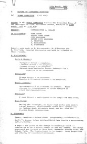
... Major concern is reinstatement of areas damaged by other instrumentalities Drainage Fisher Street Maidstone anticipated to completed next week Road Work During the fortnight no major road works were undertaken however reinstatement carried out in Furlong Road, Allandale Road and Ballarat Road / Station Road Intersection Selwyn Park Tennis Pavilion progressing satisfactorily Aycliffe Avenue Infant Welfare Centre & Child Care Centre progressing satisfactorily Report of buildings damaged due to dry summer More Park, Sunshine Bowling Club & Selwyn Park Orama Street Child Care Centre landscaping in progress Sassella Park work will commence at the end of the Little Athletics Season Major Work is centred on preparation of the grounds for the commencement of the football season I.C.I. ...Major concern is reinstatement of areas damaged by other instrumentalities Drainage Fisher Street Maidstone anticipated to completed next week Road Work During the fortnight no major road works were undertaken however reinstatement carried out in Furlong Road, Allandale Road and Ballarat Road / Station Road Intersection Selwyn Park Tennis Pavilion progressing satisfactorily Aycliffe Avenue Infant Welfare Centre & Child Care Centre progressing satisfactorily Report of buildings damaged due to dry summer More Park, Sunshine Bowling Club & Selwyn Park Orama Street Child Care Centre landscaping in progress Sassella Park work will commence at the end of the Little Athletics Season Major Work is centred on preparation of the grounds for the commencement of the football season I.C.I. ...Report of Committee Meetings 11th March 1980 Report of Works Committee Meeting Kerb & Channel Navigator Street Maribyrnong completed Kerb & Channel Lindenow Street Maidstone in progress Kerb & Channel Forrest Street in progress Kerb & Channel Raleigh Road / Navigator Street Maribyrnong Intersection requires to be excavated Footpath Myamyn Street Braybrook in progress Footpath Hampton Street & Elizabeth Street Braybrook in progress Reinstatements Approximatley 6 to 9 months in arrears. Major concern is reinstatement of areas damaged by other instrumentalities Drainage Fisher Street Maidstone anticipated to completed next week Road Work During the fortnight no major road works were undertaken however reinstatement carried out in Furlong Road, Allandale Road and Ballarat Road / Station Road Intersection Selwyn Park Tennis Pavilion progressing satisfactorily Aycliffe Avenue Infant Welfare Centre & Child Care Centre progressing satisfactorily Report of buildings damaged due to dry summer More Park, Sunshine Bowling Club & Selwyn Park Orama Street Child Care Centre landscaping in progress Sassella Park work will commence at the end of the Little Athletics Season Major Work is centred on preparation of the grounds for the commencement of the football season I.C.I. Oval inspection and final decision of steps to be taken to improve the ground Selwyn Park recently grassed area is progressing satisfactorily Ralph Street Reserve power being switched off at meters thereby rendering the sprinklers non operable Report of the Finance Committee Report of the Swimming Instruction Staff Matters Action Waste Collections Pty Ltd Legal proceedings Project Cost Analysis for Period Ended 11th February 1980 Report of the City Engineer & Planner Cherry Crescent Child Care Centre Braybrook navigator street, maribyrnong, lindenow street, forrest street, sunshine, ardeer, raleigh road, myamyn street, hampton street, elizabeth street, braybrook, fisher street, maidstone, furlong road, sunshine north, allandale road, kings park, ballarat road, station road, deer park, albion tennis club, albion tennis club pavilion, selwyn street, albion, aycliffe avenue infant welfare centre & child care, aycliffe avenue, more park, sunshine bowling club, anderson road, deer park little athletics centre, i.c.i. oval, ralph street reserve, ralph street, sunshine west, action waste collections, cherry crescent child care centre, cherry crescent -
Emerald Museum & Nobelius Heritage Park
Tool - Axe
... There is minor damage to the edge; otherwise it is in good condition. Emerald Victoria Australia Aboriginal culture Hunting Burial grounds R. ...Comment from Andrea Murphy, aboriginal heritage consultant, Upper Beaconsfield, January 2006: This is an axe head, which was most common and the most important implement in the aboriginal stone "assemblage". The implement was a man's tool and would have been in daily use to cut wood off trees, cut notches for foot-holds for climbing trees, or to dispatch game. The axe head was often hafted with resin on to a hard-wood stick. The implement is of diorite or greenstone (although black in appearance), which was obtained from an aboriginal quarry at Mount William in the Lancefield area. Stone from this quarry was often traded for other goods and has been found as distant as Queensland. A piece of greestone this size, unground, was considered worth a possum-skin cloak (a cloak took approximately 28 possum skins). Trading in greenstone therefore had social significance. This type of implement was often handed down from one generation to the next. It was sometimes buried with the dead. The edge of the axe was formed by grinding on a rougher stone. Working with greenstone more recent techonology [than the other stones]. This implement is reasonably small but is a good example of symmetrical grinding. There is minor damage to the edge; otherwise it is in good condition.Aboriginal stone axe found circa 1921 and donated by R. DouglasStoneemerald, victoria, australia, aboriginal culture, hunting, burial grounds, r. douglas
