Showing 25 items matching "dept of conservation"
-
 Lakes Entrance Historical Society
Map - Bairnsdale Region/Nowa Nowa Operations Area, Dept of Conservation and Natural Resources, February 1980
... Dept of Conservation and Natural Resources...Map Bairnsdale Region/Nowa Nowa Operations Area Dept of Conservation and Natural Resources ...Shows forest area, roads, tracks, operational boundery, private property, fire tower, helipad, Renic area hut.forest, roads and streets, private property, fire tower, helipad, huts -
 Wodonga & District Historical Society Inc
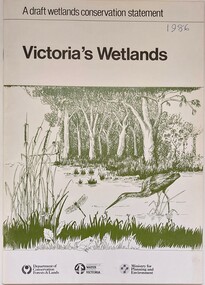
Book - Victoria's Wetlands, Dept. of Conservation, Forests & Lands, 1986
... Dept. of Conservation, Forests & Lands...On foot of cover: Department of Conservation, Forests & Lands, Department of Water Resources, Victoria, Ministry for Planning and Environment An 22 page book containing maps and illustrations Victoria's Wetlands Book Victoria's Wetlands Dept. of Conservation, Forests & Lands ...This publication was the result of an inquiry into the state of wetland environments in Victoria. It produced a draft strategy for conservation of threatened areas in the future.An 22 page book containing maps and illustrationsThis publication was the result of an inquiry into the state of wetland environments in Victoria. It produced a draft strategy for conservation of threatened areas in the future.wetland protection, wetlands victoria, water conservation -
Koorie Heritage Trust
Book, Brown, Rik, The upper Yarra River corridor : sites of conservation significance, 1993
... Dandenong, Vic. : Dept. of Conservation and Natural Resources, Dandenong Region...Dandenong, Vic. : Dept. of Conservation and Natural Resources, Dandenong Region ...179 p.; maps; appendices; 30 cm.environmental protection -- victoria -- yarra river region. floodplain management -- victoria -- yarra river region. ecology -- victoria -- yarra river region. biodiversity conservation -- victoria -- yarra river region. yarra river region (vic.) -
 Beechworth Honey Archive
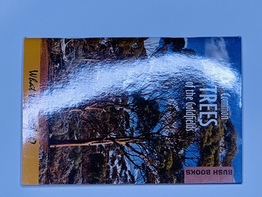
Publication, Common Trees of the Goldfields (Grant Pronk) Dept of Environment & Conservation - Bush Books, 2012
... Common Trees of the Goldfields (Grant Pronk) Dept of Environment & Conservation - Bush Books...Beechworth Honey Archive 87 Ford Street Beechworth high-country Soft cover slightly larger than A7, Photograph of Gimlet woodland on the front & back, white & black writing Common Trees of the Goldfields (Grant Pronk) Dept of Environment & Conservation - Bush Books Publication ...Soft cover slightly larger than A7, Photograph of Gimlet woodland on the front & back, white & black writing -
Marysville & District Historical Society
THE TRIANGLE NEWS-VOL 11 NO 4-21 FEBRUARY 1986
... ...dept of conservation forest and lands...Marysville & District Historical Society 39 Darwin Street Marysville yarra-valley-and-the-dandenong-ranges marysville victoria australia lions ladies tupperware party new babes coffee morning senior citizens baby sitting happy anniversary shopping spree tour community employment program marysville saddle tramps happy birthday kindergarten roster toddler/play group lost dept of conservation forest and lands interruption to s.e.c. supply house to rent wanted for sale buying or selling house or land shire of alexandra mechanic strawberries marysville hardware igloo roadhouse new owners baby sitter required narbethong tennis coaching roofs agistment christ church anglican church marysville newsagency st thomas' buxton THE TRIANGLE NEWS-VOL 11 NO 4-21 FEBRUARY 1986 ...marysville, victoria, australia, lions ladies tupperware party, new babes coffee morning, senior citizens, baby sitting, happy anniversary, shopping spree tour, community employment program, marysville saddle tramps, happy birthday, kindergarten roster, toddler/play group, lost, dept of conservation forest and lands, interruption to s.e.c. supply, house to rent, wanted, for sale, buying or selling house or land, shire of alexandra, mechanic, strawberries, marysville hardware, igloo roadhouse new owners, baby sitter required narbethong, tennis coaching, roofs, agistment, christ church anglican church, marysville newsagency, st thomas' buxton -
Tatura Irrigation & Wartime Camps Museum
Booklet, The State of the Rivers, 1983
... ...dept of conservation...Tatura Irrigation & Wartime Camps Museum 49 Hogan Street Tatura the-murray Produced to present an overall review of the state of our rivers the state of the rivers victorian rivers dept of conservation forests land and state rivers documents reports Cream cover. ...Produced to present an overall review of the state of our riversCream cover. Bushland scene, mist above small waterfallthe state of the rivers, victorian rivers, dept of conservation, forests, land and state rivers, documents, reports -
 Peterborough History Group
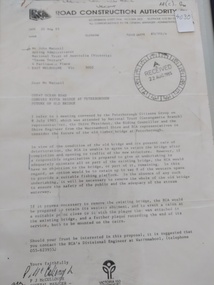
Document - Three letters pertaining to the retention of the Old Bridge
... RCA letter is stamped "Received 22 Aug 1985", Dept of Conservation Forests & Lands has a pencilled phone no inscribed....Its sentimental value saw locals attempt (although unsuccessfully) to retain the old bridge. peterborough curdies river bridge old peterborough bridge department of conservation forest & lands road construction authority RCA letter is stamped "Received 22 Aug 1985", Dept of Conservation Forests & Lands has a pencilled phone no inscribed. ...Upon confirmation that a new bridge was to be built, there was some discussion about the possibility of retaining the old bridge for pedestrian purposes, or part of the old bridge as a fishing platform. These letters are part of the correspondence re an organisation taking responsibility for the ongoing maintenance so the old bridge could be retained.The old bridge was constructed of locally sourced timber and was such an important structure to the town when built. Its sentimental value saw locals attempt (although unsuccessfully) to retain the old bridge.Two A4 Typewritten letters, one from the Road Construction Authority to the National Trust Australia, the other from the Department of Conservation Forests & Lands to Mr John Irvine. And one hand written letter.RCA letter is stamped "Received 22 Aug 1985", Dept of Conservation Forests & Lands has a pencilled phone no inscribed.peterborough, curdies river bridge, old peterborough bridge, department of conservation forest & lands, road construction authority -
 City of Ballarat Libraries
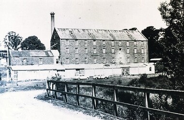
Photograph - Card Box Photographs, Anderson's Mill, Smeaton circa 1960
... Acquired by the then Dept of Conservation Forests & Lands who restored the building & replaced long iron shed with timber veranda....City of Ballarat Libraries Eureka Centre Eureka Street Ballarat East goldfields Acquired by the then Dept of Conservation Forests & Lands who restored the building & replaced long iron shed with timber veranda. ...Acquired by the then Dept of Conservation Forests & Lands who restored the building & replaced long iron shed with timber veranda.anderson's mill, smeaton, building, manufacturing, vehicle -
 Bendigo Historical Society Inc.
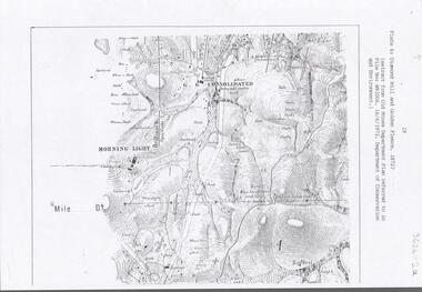
Document - DIAMOND HILL AREA MAP
... Map copy, 2 pages, from 'Old Mines Department Plan, Dept of Conservation and Environment File No W91006, 16.6.1972' Map shows Golden Gully area with 'Town and Country Hotel' on north side and further south, with shafts and mine names marked....History House 11 Mackenzie Street Bendigo goldfields BENDIGO Mining diamond hill Map copy, 2 pages, from 'Old Mines Department Plan, Dept of Conservation and Environment File No W91006, 16.6.1972' Map shows Golden Gully area with 'Town and Country Hotel' on north side and further south, with shafts and mine names marked. ...Map copy, 2 pages, from 'Old Mines Department Plan, Dept of Conservation and Environment File No W91006, 16.6.1972' Map shows Golden Gully area with 'Town and Country Hotel' on north side and further south, with shafts and mine names marked.bendigo, mining, diamond hill -
 Kiewa Valley Historical Society
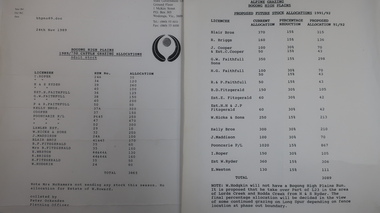
Papers - Cattle Grazing, Bogong High Plains
... 4 pages with black print: 1. 1989/90 Cattle Grazing Allocation and Dept. of Conservation Forests and Lands, Wodonga. 2. .... / Benalla / Received 22nd Feb. 1979 / signed 4 pages with black print: 1. 1989/90 Cattle Grazing Allocation and Dept. of Conservation Forests and Lands, Wodonga. 2. ...Cattle grazing. In the 1990s government departments allocated the number of cattle being taken up to the Bogong High Plains by the families who traditionally leased land there.Cattle grazing had been banned in other Alpine areas due to concerns of their impact on the environment. Kiewa Valley cattle graziers were caught up in the controversy as it was their tradition dating back to the 1840s. This controversy continues as cattle grazing was banned in 2005. 4 pages with black print: 1. 1989/90 Cattle Grazing Allocation and Dept. of Conservation Forests and Lands, Wodonga. 2. Proposed Future Stock Allocations 1991/92 list of 16 families 3. & 4. List of families, ear marks, brands etc. dated 22nd Feb. 1979 stapled togetherex S.C.A. / Benalla / Received 22nd Feb. 1979 / signedcattle grazing, kiewa valley farmers -
Southern Sherbrooke Historical Society Inc.
Information folder - Lockwood House
... -typescript, "Holidays In The Dandenongs" -printed sheets, "Doongala Forest Reserve", Dept of Conservation, Forests & Lands, includes map of Doongalla walking tracks, hand-written on back "Doongala/751 1717/Open week days except/Thursday....-typescript, "Holidays In The Dandenongs" -printed sheets, "Doongala Forest Reserve", Dept of Conservation, Forests & Lands, includes map of Doongalla walking tracks, hand-written on back "Doongala/751 1717/Open week days except/Thursday. ...Folder containing items pertaining to the history of Lockwood House, Belgrave Heights. Contents: -notes, hand-written, on holidays in Belgrave Heights, 6 sheets on Ansett memo pad. -typescript, "Holidays In The Dandenongs" -printed sheets, "Doongala Forest Reserve", Dept of Conservation, Forests & Lands, includes map of Doongalla walking tracks, hand-written on back "Doongala/751 1717/Open week days except/Thursday./Open weekends by appointment" -5 Certificates of Title for parcels of land included in Lockwood Estate.lockwood house, elvery family, guesthouses -
 Bendigo Historical Society Inc.
Document - PETER ELLIS COLLECTION: LETTER FROM BENDIGO FIELD NATURALISTS CLUB
... Conservation Council of Victoria... National Estate Dept...Photocopy of an unsigned letter from The Bendigo Field Naturalists Club with copies sent to the Ministry for Conservation, Premier of Victoria, National Estate Dept, Forests Commission of Victoria, Conservation Council of Victoria, Loddon Campaspe Regional Authority, The Hon D McClure MLA, the Hon F S Grimwade MLC, F J Granter MLC, N B Reid MLC and J Bourchier MP. ...History House 11 Mackenzie Street Bendigo goldfields COMMUNICATION Postal letters Peter Ellis Collection The Bendigo Field Naturalists Club National Estate Funds Forests Commission of Vict Wallaby Caves Mr Ruedin Conservation Council of Victoria National Estate Dept Whipstick Interim Development Order Loddon Campaspe Regional Authority The Hon D McClure MLA The Hon F S Grimwade MLC F J Granter MLC N B Reid MLC J Bourchier MP Photocopy of an unsigned letter from The Bendigo Field Naturalists Club with copies sent to the Ministry for Conservation, Premier of Victoria, National Estate Dept, Forests Commission of Victoria, Conservation Council of Victoria, Loddon Campaspe Regional Authority, The Hon D McClure MLA, the Hon F S Grimwade MLC, F J Granter MLC, N B Reid MLC and J Bourchier MP. ...Photocopy of an unsigned letter from The Bendigo Field Naturalists Club with copies sent to the Ministry for Conservation, Premier of Victoria, National Estate Dept, Forests Commission of Victoria, Conservation Council of Victoria, Loddon Campaspe Regional Authority, The Hon D McClure MLA, the Hon F S Grimwade MLC, F J Granter MLC, N B Reid MLC and J Bourchier MP. Letter refers to the Purchase of land of high conservation value within the Bendigo Whipstick area for consideration in the National Estate Program.communication, postal, letters, peter ellis collection, the bendigo field naturalists club, national estate funds, forests commission of vict, wallaby caves, mr ruedin, conservation council of victoria, national estate dept, whipstick interim development order, loddon campaspe regional authority, the hon d mcclure mla, the hon f s grimwade mlc, f j granter mlc, n b reid mlc, j bourchier mp -
 Orbost & District Historical Society
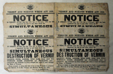
map/poster, Victorian Government Printer, 22.4.1926
... Conservation, Forests and Land. It was responsible for the management of the State's Crown land and pastoral estates. This map was used by Don Mehlert after 1928. The VERMIN AND NOXIOUS WEEDS ACT 1928 was an Act to consolidate the Law relating relating to Vermin and Noxious Weeds. E. J. E. G. Pemberton who published this poster was Superintendent of Field Staff, Dept...Conservation, Forests and Land. It was responsible for the management of the State's Crown land and pastoral estates. This map was used by Don Mehlert after 1928. The VERMIN AND NOXIOUS WEEDS ACT 1928 was an Act to consolidate the Law relating relating to Vermin and Noxious Weeds. E. J. E. G. Pemberton who published this poster was Superintendent of Field Staff, Dept ...The Department of Crown Lands and Survey was originally established in 1857 as part of the Board of Land and Works. In 1964 it ceased to be controlled by the Board. The Department functioned for almost twenty more years before being combined with other Ministries to form the Department of Conservation, Forests and Land. It was responsible for the management of the State's Crown land and pastoral estates. This map was used by Don Mehlert after 1928. The VERMIN AND NOXIOUS WEEDS ACT 1928 was an Act to consolidate the Law relating relating to Vermin and Noxious Weeds. E. J. E. G. Pemberton who published this poster was Superintendent of Field Staff, Dept. of Lands and Survey. This map and posters are significant records of early settlement history in Murrangower, between Cabbage Tree and Orbost,A paper map of Murrangower showing settlement subdivisions. This is glued onto the back of four overlapping cloth poster of "Notices of Vermin Destruction". All print is black."DON MEHLERT" in black pen. Pike's block shaded in blue. School site marked in blue pencil. on poster "MURRANGOWAR" along side.map-murrangower poster-vermin-and-noxious-weeds murrangower-settlement -
Phillip Island and District Historical Society Inc.
Book, Heritage Victoria, Gippsland Heritage Project. Prospectus, 1996
... Phillip Island and District Historical Society Inc. phillip-island-and-the-bass-coast historic buildings victoria conservation restoration historic sites cultural property protection gippsland buildings structures 316003/96 Gippsland Heritage Project. Prospectus Book Heritage Victoria. Public Affairs, Dept ...316003/96historic buildings, victoria, conservation, restoration, historic sites, cultural property, protection, gippsland, buildings, structures -
 Ballarat Tramway Museum
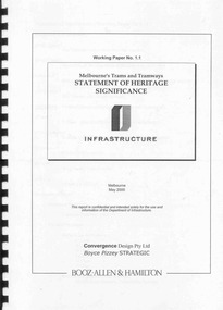
Document - Report, Boyce Pizzey and Booz Allen & Hamilton, "Working paper No. 1.1, Melbourne's Tram and Tramways Statement of Heritage Significance", May. 2000
... Ballarat Tramway Museum South Gardens Reserve Wendouree Parade Ballarat Ballarat goldfields Trams tramways Melbourne Heritage Trams Museum Conservation Various pencil notes throughout by Warren Doubleday Bound report, 48 pages, clear plastic front cover, black card back cover, and black comb binder titled "Working paper No. 1.1, Melbourne's Tram and Tramways Statement of Heritage Significance". Prepared for the Dept ...Bound report, 48 pages, clear plastic front cover, black card back cover, and black comb binder titled "Working paper No. 1.1, Melbourne's Tram and Tramways Statement of Heritage Significance". Prepared for the Dept. of Infrastructure, May 2000, by Booz Allen & Hamilton, Convergence Design Pty Ltd and Boyce Pizzey Strategic. Provides a background, evolution of Melbourne's Tramways, Elements if Significance, the tramway system as an entity. Social and Cultural Influences and a Statement of Significance. Provides a brief history of the Melbourne's Trams and Tramways as an appendix along with some photographs, maps, sources, bibliography, illustrations, photographs, a list of Melbourne and suburban tramways, a list of Pre-MMTB cars, and MMTB cars preserved in Museums in Australia. Has corrections on the list. As a loose item, has a list of corrections prepared by Warren Doubleday. See Reg items 4264 and 4265 for associated papers. Various pencil notes throughout by Warren Doubledaytrams, tramways, melbourne, heritage, trams, museum, conservation -
 University of Melbourne, Burnley Campus Archives
Document - Photocopy, Diane Mathews, Killamont: Conservation Analysis of the Historic Garden of Killamont, July 1991
... diane matthews rmit department of landscape and architecture killamont conservation analysis plan garden plan Copy of Final Project, Dept. of Landscape Architecture, Royal Melbourne Institute of Technology, July 1991 by Diane Matthews. ...Copy of Final Project, Dept. of Landscape Architecture, Royal Melbourne Institute of Technology, July 1991 by Diane Matthews. Printed sketch of Killamont, Homestead. 20 labelled colour photographs and negatives in a plastic folder labelled, "Killamont very late 1990's or early 2000's." 3 scanned colour photographs from Sandra Pullman.Copy of Handdrawn plan labelled, "Plan showing proposed lines for fencing and tiled drains and position of reception dam in connection with garden scheme K." Letter to Sandra (Pullman) feom Wendy with attached sletch of the garden 1990.diane matthews, rmit, department of landscape and architecture, killamont, conservation analysis, plan, garden plan -
 Lakes Entrance Historical Society
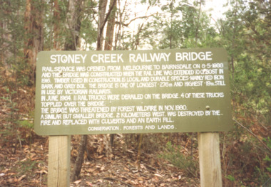
Photograph - Stoney Creek Bridge Nowa Nowa Victoria, Davies Judy, c1990
... Colour photograpf of the sign erected by the Conservation, Forests and Lands Dept. at the Stoney Creek Bridge Nowa Nowa Victoria . ...Lakes Entrance Historical Society 4 Marine Parade Lakes Entrance gippsland Bridges Forestry Tourism Topography Colour photograpf of the sign erected by the Conservation, Forests and Lands Dept. at the Stoney Creek Bridge Nowa Nowa Victoria . ...Colour photograpf of the sign erected by the Conservation, Forests and Lands Dept. at the Stoney Creek Bridge Nowa Nowa Victoria . Plus two other photos of the bridgebridges, forestry, tourism, topography -
University of Melbourne, Burnley Campus Archives
Document - Plant List, Dept. of Sustainability and Environment, Advisory List of Rare or Threatened Plants in Victoria 2005, 2005
... Conservation Status. Advisory List of Rare or Threatened Plants in Victoria 2005 Document Plant List Dept. of Sustainability and Environment ...plants, plant list, victoria, endangered plants, conservation -
Save the Dandenongs League Inc.
Document (item), Save the Dandenongs League Incorporated, S.D.L. Correspondence - 1990 to December 1991 [Part 4 of 10]: Dept. of Conserv. and Environment
... Department of Conservation and Environment S.D.L. Correspondence - 1990 to December 1991 [Part 4 of 10]: Dept. of Conserv. and Environment Document Save the Dandenongs League Incorporated ...department of conservation and environment -
Save the Dandenongs League Inc.
Document (item), Save the Dandenongs League Incorporated, Letters Etc. 87-90 [Part 4 of 10]: Ministry & Dept CF&L
... Department of Conservation Forests & Lands Letters Etc. 87-90 [Part 4 of 10]: Ministry & Dept CF&L Document Save the Dandenongs League Incorporated ...department of conservation forests & lands -
Save the Dandenongs League Inc.
Document (item), Save the Dandenongs League Incorporated, Save the Dandenongs League Correspondence 1984-1985 [Part 9 of 14]: Dept & Ministry Conserv Forests & Lands
... Department of Conservation Forests & Lands Save the Dandenongs League Correspondence 1984-1985 [Part 9 of 14]: Dept & Ministry Conserv Forests & Lands Document Save the Dandenongs League Incorporated ...department of conservation forests & lands -
Save the Dandenongs League Inc.
Document (item), Save the Dandenongs League Incorporated, Save the Dandenongs League Incorporated - January 1986 to September 1986 - Correspondence [Part 4 of 11]: Dept & Mnistry Conserv. Forests & Lands
... Department of Conservation Forests & Lands Save the Dandenongs League Incorporated - January 1986 to September 1986 - Correspondence [Part 4 of 11]: Dept & Mnistry Conserv. ...department of conservation forests & lands -
Save the Dandenongs League Inc.
Document (item), Save the Dandenongs League Incorporated, Save the Dandenongs League Incorporated - October 1986 to September 1987 - Correspondence [Part 3 of 11]: Dept. & Ministry CF & L
... Department of Conservation Forests & Lands Save the Dandenongs League Incorporated - October 1986 to September 1987 - Correspondence [Part 3 of 11]: Dept. & Ministry CF & L Document Save the Dandenongs League Incorporated ...department of conservation forests & lands -
Save the Dandenongs League Inc.
Document (item), Save the Dandenongs League Incorporated, Save the Dandenongs League Incorporated - October 1987 to [no date] - Correspondence [Part 2 of 9]: Ministry & Dept CF & L
... Department of Conservation Forests & Lands Save the Dandenongs League Incorporated - October 1987 to [no date] - Correspondence [Part 2 of 9]: Ministry & Dept CF & L Document Save the Dandenongs League Incorporated ...department of conservation forests & lands -
 Bendigo Historical Society Inc.
Document - PETER ELLIS COLLECTION: LETTER, 4th October, 1976
... Dept of Crown Lands and Survey... Ministry for Conservation...COMMUNICATION Postal letters Peter Ellis Collection The Bendigo Field Naturalists Club Proposed Boyd St Nature Reserve The Hon W A Borthwick Recreation Reserve Extension (Rs 3458) Cemetry Reserve Extension (Rs 3777) Rubbish Depot (Rs 5980) Education Purposes Reserve J Willis Bendigo City Council City Boundary Stone Quarry Hill Golf Club Canberra Botanical Gardens Stony Ridge Flora Reserve Sydney Kings Park Perth Maranoa Gardens Melbourne Kaweka Sanctuary Castlemaine Central and Northern Branch of the National Trust School Sanctuary (Quarry hill) Education Dept Society for Growing Australian Plants - Bendigo Group Lawn Cemetery Bendigo City Council Parks and Recreation Dept Bendigo Trust Afforestation Committee Quality of Life Action Group Ackhurst Plan Winifred Waddell Estate Dept of Crown Lands and Survey Ministry for Conservation Mr G Edwards Mr M Goode Mr J Chellacombe Diana R Collier Letter, dated 4/10/1976 from Diana R. ...Letter, dated 4/10/1976 from Diana R. Collier, Hon. Secretary, The Bendigo Field Naturalists Club to The Minister for Lands, The Hon. W. A. Borthwick making an application to have a reserved area for the preservation of native flora and fauna near the Quarry Hill Golf Club. Features, fauna and flora are mentioned including an original Boundary Stone and the Fairy Waxflower (Eriostemon verrucosus) also known as the Bendigo Wax Flower. Included is a list of birds (including some that nest in the area sometimes) and plants.communication, postal, letters, peter ellis collection, the bendigo field naturalists club, proposed boyd st nature reserve, the hon w a borthwick, recreation reserve extension (rs 3458), cemetry reserve extension (rs 3777), rubbish depot (rs 5980), education purposes reserve, j willis, bendigo city council, city boundary stone, quarry hill golf club, canberra botanical gardens, stony ridge flora reserve sydney, kings park perth, maranoa gardens melbourne, kaweka sanctuary castlemaine, central and northern branch of the national trust, school sanctuary (quarry hill), education dept, society for growing australian plants - bendigo group, lawn cemetery, bendigo city council parks and recreation dept, bendigo trust afforestation committee, quality of life action group, ackhurst plan, winifred waddell estate, dept of crown lands and survey, ministry for conservation, mr g edwards, mr m goode, mr j chellacombe, diana r collier