Showing 33 items matching "derham house"
-
 Kew Historical Society Inc
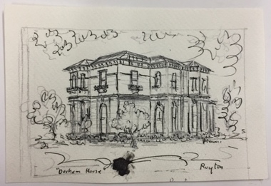
Work on paper, Joy Stewart, Derham House, Ruyton, c.1978
... Derham House, Ruyton......derham house (ruyton)...Prelimiinary sketch of 'Derham House, Ruyton' by the artist Joy Stewart. ...Inscription: "Derham House, Ruyton"....Joy Stewart died in Cairns in 2018. joy stewart derham house (ruyton) Inscription: "Derham House, Ruyton". ...Sydney Joy (joy) Stewart (1925-2018) was a founding member of the Kew Historical Society, and during the 1970s its secretary. During her residence in Kew, she completed numerous property illustrations on commission. These ranged from preliminary sketches, including architectural details to finished pen & ink and wash illustrations on paper. On moving to Queensland, Joy Stewart donated the remaining property illustrations in her possession to the Kew Historical Society. In 1987-88, she fulfilled a commission by the Society of designs for a series of embroideries completed by residents during the Australian Bicentennial commemorations.Sydney Joy (Joy) Stewart was born in Melbourne 1925. She studied at Swinburne Technical College Art School from 1941-1945, then the National Gallery Art School 1946-1948. Her career included employment positions as a display artist, designer/painter, gallery assistant, and art teacher. Joy relocated to Cairns in 1981. Solo exhibitions in Melbourne and Cairns, including 'Done By Me' at Cairns Regional Gallery in 1999. Group exhibitions at Cairns Regional Gallery, 'The Fish John West Regrets, 1993' and 'Facets of Life' 1994. Joy Stewart died in Cairns in 2018.Prelimiinary sketch of 'Derham House, Ruyton' by the artist Joy Stewart. Inscription: "Derham House, Ruyton".joy stewart, derham house (ruyton) -
 Kew Historical Society Inc
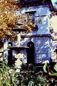
Slide - Derham House (formerly 'Mount View), 8 Selbourne Road, 1979
... Derham House (formerly 'Mount View), 8 Selbourne Road......derham house...Colour positive transparency (slide) of the the fountain and garden of Derham House, formerly 'Mount View', 8 Selbourne Road, Kew. ..."Fountain Ruyton in front of Derham House"...The slides represent a snapshot in time of built architecture in Kew, much of which has changed in the forty-plus period since they were created. historic houses -- kew (vic.) ruyton girls' school derham house mount view italianate architecture fountains "Fountain Ruyton in front of Derham House" Colour positive transparency (slide) of the the fountain and garden of Derham House, formerly 'Mount View', 8 Selbourne Road, Kew. ...One of a group of slides taken by members of the Society of built heritage in Kew in 1979-80. The selection of subject matter reflects the priorities of the period. The colour of some slides has degraded.The slides represent a snapshot in time of built architecture in Kew, much of which has changed in the forty-plus period since they were created.Colour positive transparency (slide) of the the fountain and garden of Derham House, formerly 'Mount View', 8 Selbourne Road, Kew. The house wa designed in 1888 by the architect Frederick de Garis as his home. Prue Sanderson, 'Kew Conservation Study: Vol.II" wrote about Mount View that: "The house is typical of the late Victorian period in it being clad in render and styled in the Italianate. It has an asymmetrical composition with polygon bay windows extending up both floors, to each of the main facades. The ground floor is heavily incised with banded rustication, while the first floor is distinguished by the cast iron balconettes to each window. The fountain and pond in the garden appear to be those depicted in the 1903 MMBW plan of the property.""Fountain Ruyton in front of Derham House"historic houses -- kew (vic.), ruyton girls' school, derham house, mount view, italianate architecture, fountains -
 Kew Historical Society Inc
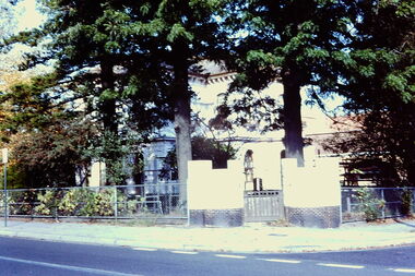
Slide - 'Derham House', Ruyton Girls' School, 1979
... 'Derham House', Ruyton Girls' School...derham house...35mm colour transparency (slide) of 'Derham House' on the corner of Wellington Street and Selbourne Avenue; now part of Ruyton. ...The photo was developed in May 1979. Slide 'Derham House', Ruyton Girls' School ...One of a group of slides taken by members of the Society of built heritage in Kew in 1979-80. The selection of subject matter reflects the priorities of the period. The colour of some slides has degraded.The slides represent a snapshot in time of built architecture in Kew, much of which has changed in the forty-plus period since they were created. 35mm colour transparency (slide) of 'Derham House' on the corner of Wellington Street and Selbourne Avenue; now part of Ruyton. The photo was developed in May 1979.derham house, ruyton girls' school -
 Port Melbourne Historical & Preservation Society
Photograph - Photocopy, Aerial view, Swallow & Ariell to infilled Lagoon, 1946
... . ; three storey Derham houses .... ; three storey Derham houses Photograph Photocopy, Aerial view, Swallow & Ariell to infilled Lagoon ...Donor was researching property on the corner of Stokes and Graham St, as old timers claim it was "the Nelson Hotel" although there is no record of such in licensing records. Particular building is at upper left of this image.Large photocopy of an aerial photo. 1946 view from Swallow & Ariell to the infilled lagoon and HMAS Barracks. Poor quality image but shows St Joseph's Catholic Church; Holy Trinity; Edwards Park; Lady Forster Kindergarten; Methodist Church on Graham St (no longer there), Bay St. ; three storey Derham houses built environment - industrial, industry - food, swallow & ariell ltd, religion - anglican (holy trinity), religion - wesleyan methodist church, religion - roman catholic church (st josephs), nelson hotel, frederick thomas derham, built environment - domestic, business and traders - hotels -
 Port Melbourne Historical & Preservation Society
Photograph - Two houses in Rouse Street, Port Melbourne belonging to Thomas SWALLOW and T H ARIELL, Charles Nettleton, c. 1871-73
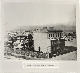
... ARIELL's house (and partnership) was taken over after his death by Frederick DERHAM. Appears to be photographed from original Swallow home across the street. ...Photographic copy of a photo of two houses on the north east corner of Rouse and Stokes Streets belonging to Thomas SWALLOW and T.H. ARIELL c1871-73 (Cat no 679.01). Labelled "Derham's... Charles NETTLETON Thomas SWALLOW Photographic copy of a photo of two houses on the north east corner of Rouse and Stokes Streets belonging to Thomas SWALLOW and T.H. ARIELL c1871-73 (Cat no 679.01). Labelled "Derham's ...ARIELL's house (and partnership) was taken over after his death by Frederick DERHAM. Appears to be photographed from original Swallow home across the street. Used for Council display purposes and still mounted with caption together with photo of POOLMAN's house.(Cat no. 683). Houses demolished 1950s. A building on the left of the photo bears the words "W KENYON / HAPPY HOME HOTEL". William Kenyon was licensee of the Happy Home Hotel in 1871-72 and W Kenyon was listed as the occupier 1872-73. (See Hotels research by Peter Libbis, Cat No 2978).Photographic copy of a photo of two houses on the north east corner of Rouse and Stokes Streets belonging to Thomas SWALLOW and T.H. ARIELL c1871-73 (Cat no 679.01). Labelled "Derham's three storey house in Rouse Street" as part of a display prepared by Council. Sepia photograph mounted on card with Poolman's House (Cat no 683).built environment - domestic, thomas harris ariell, frederick thomas derham, charles nettleton, thomas swallow -
 Bendigo Historical Society Inc.
Photograph - LONG GULLY HISTORY GROUP COLLECTION: LONG GULLY WINNERS HOSE PRACTICE FOR EIGHT MEN
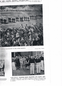
... History House 11 Mackenzie Street Bendigo goldfields BENDIGO History long gully history group The Long Gully History Group - Brigade Review and Long Gully Winners Hose Practice for Eight Men W Tibbett F Arthur W Stewart E Miller H Harvey H Derham W H Robinson Vincent Kelly B Mitchell T Smith G Hall W Wearne W Trahair J Waterson A Polglaise A Truscott Copy of two fire brigade photos. ...Copy of two fire brigade photos. The top one shows the Review in the Upper Reserve with the band in the foreground and the brigade teams marching on the reserve. The lower photos Long Gully, Winners Hose Practice for Eight Men. Team members are: B Mitchell, T Smith, G Hall, W Wearne, W Trahair, J Waterson, A Polglaise and A Truscott. Photographers were Vincent Kelly and W H Robinson.bendigo, history, long gully history group, the long gully history group - brigade review and long gully winners hose practice for eight men, w tibbett, f arthur, w stewart, e miller, h harvey, h derham, w h robinson, vincent kelly, b mitchell, t smith, g hall, w wearne, w trahair, j waterson, a polglaise, a truscott -
 Port Melbourne Historical & Preservation Society
Photograph - Two houses in Rouse Street, Port Melbourne belonging to Thomas SWALLOW and T H ARIELL, Charles Nettleton, c. 1871-73
... ARIELL's house (and partnership) was taken over after his death by Frederick DERHAM. Appears to be photographed from original Swallow home across the street. ...Port Melbourne Historical & Preservation Society Port Melbourne Town Hall 333 Bay Street Port Melbourne melbourne ARIELL's house (and partnership) was taken over after his death by Frederick DERHAM. Appears to be photographed from original Swallow home across the street. ...ARIELL's house (and partnership) was taken over after his death by Frederick DERHAM. Appears to be photographed from original Swallow home across the street. A building on the left of the photo bears the words "W KENYON / HAPPY HOME HOTEL". William Kenyon was licensee of the Happy Home Hotel in 1871-72 and W Kenyon was listed as the occupier 1872-73. (See Hotels research by Peter Libbis, Cat No 2978).Large B&W photo of two houses on the north east corner of Rouse and Stokes Streets belonging to Thomas SWALLOW and T.H. ARIELL c1871-73 in a grey cardboard mount with a border consisting on thin overlapping black lines. "C NETTLETON PHOTO" at bottom left and "MELBOURNE" at bottom right."9" on back in very light pencil.built environment - domestic, thomas harris ariell, frederick thomas derham, thomas swallow, charles nettleton -
 Port Melbourne Historical & Preservation Society
Photograph - Launch of History of a Street Precinct, 25 Sep
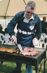
... houses in a Port Melbourne street precinct from the 1880s to 1960. The area is bounded by Evans Street, the E side of Bridge Street, S side of Williamstown Road, Farrell Street both the E & W sides plus the section of Ross Street between Farrell and Bridge and the part of Derham Street between Farrell and Bridge. ...houses in a Port Melbourne street precinct from the 1880s to 1960. The area is bounded by Evans Street, the E side of Bridge Street, S side of Williamstown Road, Farrell Street both the E & W sides plus the section of Ross Street between Farrell and Bridge and the part of Derham Street between Farrell and Bridge. ...In 2005, members of the PMH&PS undertook a study of the residents of the houses in a Port Melbourne street precinct from the 1880s to 1960. The area is bounded by Evans Street, the E side of Bridge Street, S side of Williamstown Road, Farrell Street both the E & W sides plus the section of Ross Street between Farrell and Bridge and the part of Derham Street between Farrell and Bridge. The resulting map and an interactive CD won the Best Community Research, Registers & Records project at the 2007 Victorian Community History Awards. The project was launched on the railway reserve near the corner of Evans & Farrell streets. Jack BOLT is cooking with Ken TURNER in the background.Jack Bolt cooking sausages at the launch of the History of a Street Precinct25/9/05 Jack Bolt 11jack bolt, ken turner, history of a street precinct -
 Port Melbourne Historical & Preservation Society
Photograph - Launch of History of a Street Precinct, 25 Sep
... houses in a Port Melbourne street precinct from the 1880s to 1960. The area is bounded by Evans Street, the E side of Bridge Street, S side of Williamstown Road, Farrell Street both the E & W sides plus the section of Ross Street between Farrell and Bridge and the part of Derham Street between Farrell and Bridge. ...houses in a Port Melbourne street precinct from the 1880s to 1960. The area is bounded by Evans Street, the E side of Bridge Street, S side of Williamstown Road, Farrell Street both the E & W sides plus the section of Ross Street between Farrell and Bridge and the part of Derham Street between Farrell and Bridge. ...In 2005, members of the PMH&PS undertook a study of the residents of the houses in a Port Melbourne street precinct from the 1880s to 1960. The area is bounded by Evans Street, the E side of Bridge Street, S side of Williamstown Road, Farrell Street both the E & W sides plus the section of Ross Street between Farrell and Bridge and the part of Derham Street between Farrell and Bridge. The resulting map and an interactive CD won the Best Community Research, Registers & Records project at the 2007 Victorian Community History Awards. The project was launched on the railway reserve near the corner of Evans & Farrell streets. Liana ThOMPSON is with her mother , Fay BATES/ SHAW nee DEVINE.Liana Thompson & Fay Bates the launch of the History of a Street Precinct. 25/9/05 Liana Thompson, Fay Bates (previously Shaw nee Devine)liana thompson, fay bates, history of a street precinct -
 Port Melbourne Historical & Preservation Society
Photograph - Launch of History of a Street Precinct, 25 Sep
... houses in a Port Melbourne street precinct from the 1880s to 1960. The area is bounded by Evans Street, the E side of Bridge Street, S side of Williamstown Road, Farrell Street both the E & W sides plus the section of Ross Street between Farrell and Bridge and the part of Derham Street between Farrell and Bridge. ...houses in a Port Melbourne street precinct from the 1880s to 1960. The area is bounded by Evans Street, the E side of Bridge Street, S side of Williamstown Road, Farrell Street both the E & W sides plus the section of Ross Street between Farrell and Bridge and the part of Derham Street between Farrell and Bridge. ...In 2005, members of the PMH&PS undertook a study of the residents of the houses in a Port Melbourne street precinct from the 1880s to 1960. The area is bounded by Evans Street, the E side of Bridge Street, S side of Williamstown Road, Farrell Street both the E & W sides plus the section of Ross Street between Farrell and Bridge and the part of Derham Street between Farrell and Bridge. The resulting map and an interactive CD won the Best Community Research, Registers & Records project at the 2007 Victorian Community History Awards. The project was launched on the railway reserve near the corner of Evans & Farrell streets. LL - R - unknown, Pat GRAINGER, Graham BRIDE.Penny MORRISON, Pat GRAINGER and Graham BRIDE at the launch of the History of a Street Precinct project. 25/9/05 Not Known, Pat Grainger, Graham Bridepat grainger, graham bride, history of a street precinct, penny morrison -
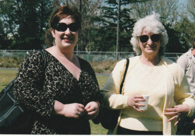
 Port Melbourne Historical & Preservation Society
Photograph - Launch of History of a Street Precinct, 25 Sep
... houses in a Port Melbourne street precinct from the 1880s to 1960. The area is bounded by Evans Street, the E side of Bridge Street, S side of Williamstown Road, Farrell Street both the E & W sides plus the section of Ross Street between Farrell and Bridge and the part of Derham Street between Farrell and Bridge. ...houses in a Port Melbourne street precinct from the 1880s to 1960. The area is bounded by Evans Street, the E side of Bridge Street, S side of Williamstown Road, Farrell Street both the E & W sides plus the section of Ross Street between Farrell and Bridge and the part of Derham Street between Farrell and Bridge. ...In 2005, members of the PMH&PS undertook a study of the residents of the houses in a Port Melbourne street precinct from the 1880s to 1960. The area is bounded by Evans Street, the E side of Bridge Street, S side of Williamstown Road, Farrell Street both the E & W sides plus the section of Ross Street between Farrell and Bridge and the part of Derham Street between Farrell and Bridge. The resulting map and an interactive CD won the Best Community Research, Registers & Records project at the 2007 Victorian Community History Awards. The project was launched on the railway reserve near the corner of Evans & Farrell streets. L- R - Natica SCHROEDER, Pat GRAINGER, Janet BOLITHO.Three members of the PMHPS the launch of the History of a Street Precinct25/9/05 Natica Schroeder, Pat Grainger, Janet Bolithohistory of a street precinct, pat grainger, natica schroeder, janet bolitho -
 Port Melbourne Historical & Preservation Society
Photograph - Launch of History of a Street Precinct, 25 Sep
... houses in a Port Melbourne street precinct from the 1880s to 1960. The area is bounded by Evans Street, the E side of Bridge Street, S side of Williamstown Road, Farrell Street both the E & W sides plus the section of Ross Street between Farrell and Bridge and the part of Derham Street between Farrell and Bridge. ...houses in a Port Melbourne street precinct from the 1880s to 1960. The area is bounded by Evans Street, the E side of Bridge Street, S side of Williamstown Road, Farrell Street both the E & W sides plus the section of Ross Street between Farrell and Bridge and the part of Derham Street between Farrell and Bridge. ...In 2005, members of the PMH&PS undertook a study of the residents of the houses in a Port Melbourne street precinct from the 1880s to 1960. The area is bounded by Evans Street, the E side of Bridge Street, S side of Williamstown Road, Farrell Street both the E & W sides plus the section of Ross Street between Farrell and Bridge and the part of Derham Street between Farrell and Bridge. The resulting map and an interactive CD won the Best Community Research, Registers & Records project at the 2007 Victorian Community History Awards. The project was launched on the railway reserve near the corner of Evans & Farrell streets. L- R - Val POWER, Jim POWER.Two members of the PMHPS the launch of the History of a Street Precinct25/9/05 Val Power, Jim Powerhistory of a street precinct, val power, jim power -
 Port Melbourne Historical & Preservation Society
Photograph - Launch of History of a Street Precinct, 25 Sep
... houses in a Port Melbourne street precinct from the 1880s to 1960. The area is bounded by Evans Street, the E side of Bridge Street, S side of Williamstown Road, Farrell Street both the E & W sides plus the section of Ross Street between Farrell and Bridge and the part of Derham Street between Farrell and Bridge. ...houses in a Port Melbourne street precinct from the 1880s to 1960. The area is bounded by Evans Street, the E side of Bridge Street, S side of Williamstown Road, Farrell Street both the E & W sides plus the section of Ross Street between Farrell and Bridge and the part of Derham Street between Farrell and Bridge. ...In 2005, members of the PMH&PS undertook a study of the residents of the houses in a Port Melbourne street precinct from the 1880s to 1960. The area is bounded by Evans Street, the E side of Bridge Street, S side of Williamstown Road, Farrell Street both the E & W sides plus the section of Ross Street between Farrell and Bridge and the part of Derham Street between Farrell and Bridge. The resulting map and an interactive CD won the Best Community Research, Registers & Records project at the 2007 Victorian Community History Awards. The project was launched on the railway reserve near the corner of Evans & Farrell streets. L- R - Robyn ?, Maralyn KOBELTMaralyn & Robin at the launch of the History of a Street Precinct25/9/05 Robyn ?, Maralyn Kobelthistory of a street precinct, maralyn kobelt -
 Port Melbourne Historical & Preservation Society
Photograph - Launch of History of a Street Precinct, 25 Sep
... houses in a Port Melbourne street precinct from the 1880s to 1960. The area is bounded by Evans Street, the E side of Bridge Street, S side of Williamstown Road, Farrell Street both the E & W sides plus the section of Ross Street between Farrell and Bridge and the part of Derham Street between Farrell and Bridge. ...houses in a Port Melbourne street precinct from the 1880s to 1960. The area is bounded by Evans Street, the E side of Bridge Street, S side of Williamstown Road, Farrell Street both the E & W sides plus the section of Ross Street between Farrell and Bridge and the part of Derham Street between Farrell and Bridge. ...In 2005, members of the PMH&PS undertook a study of the residents of the houses in a Port Melbourne street precinct from the 1880s to 1960. The area is bounded by Evans Street, the E side of Bridge Street, S side of Williamstown Road, Farrell Street both the E & W sides plus the section of Ross Street between Farrell and Bridge and the part of Derham Street between Farrell and Bridge. The resulting map and an interactive CD won the Best Community Research, Registers & Records project at the 2007 Victorian Community History Awards. The project was launched on the railway reserve near the corner of Evans & Farrell streets. Darren Ray, Mayor of City of Port Phillip.City of Port Phillip mayor, Cr Darren Ray at the launch of the History of a Street Precinct25/9/05 Darren Ray Mayor CoPPhistory of a street precinct, darren ray -
 Port Melbourne Historical & Preservation Society
Photograph - Launch of History of a Street Precinct, 25 Sep
... houses in a Port Melbourne street precinct from the 1880s to 1960. The area is bounded by Evans Street, the E side of Bridge Street, S side of Williamstown Road, Farrell Street both the E & W sides plus the section of Ross Street between Farrell and Bridge and the part of Derham Street between Farrell and Bridge. ...houses in a Port Melbourne street precinct from the 1880s to 1960. The area is bounded by Evans Street, the E side of Bridge Street, S side of Williamstown Road, Farrell Street both the E & W sides plus the section of Ross Street between Farrell and Bridge and the part of Derham Street between Farrell and Bridge. ...In 2005, members of the PMH&PS undertook a study of the residents of the houses in a Port Melbourne street precinct from the 1880s to 1960. The area is bounded by Evans Street, the E side of Bridge Street, S side of Williamstown Road, Farrell Street both the E & W sides plus the section of Ross Street between Farrell and Bridge and the part of Derham Street between Farrell and Bridge. The resulting map and an interactive CD won the Best Community Research, Registers & Records project at the 2007 Victorian Community History Awards. The project was launched on the railway reserve near the corner of Evans & Farrell streets. Janet BOLITHO, former mayor of City of Port Phillip.Former City of Port Phillip mayor, Janet Bolitho, at the launch of the History of a Street Precinct25/9/05 Janet Bolithohistory of a street precinct, janet bolitho -
 Port Melbourne Historical & Preservation Society
Photograph - Launch of History of a Street Precinct, 25 Sep
... houses in a Port Melbourne street precinct from the 1880s to 1960. The area is bounded by Evans Street, the E side of Bridge Street, S side of Williamstown Road, Farrell Street both the E & W sides plus the section of Ross Street between Farrell and Bridge and the part of Derham Street between Farrell and Bridge. ...houses in a Port Melbourne street precinct from the 1880s to 1960. The area is bounded by Evans Street, the E side of Bridge Street, S side of Williamstown Road, Farrell Street both the E & W sides plus the section of Ross Street between Farrell and Bridge and the part of Derham Street between Farrell and Bridge. ...In 2005, members of the PMH&PS undertook a study of the residents of the houses in a Port Melbourne street precinct from the 1880s to 1960. The area is bounded by Evans Street, the E side of Bridge Street, S side of Williamstown Road, Farrell Street both the E & W sides plus the section of Ross Street between Farrell and Bridge and the part of Derham Street between Farrell and Bridge. The resulting map and an interactive CD won the Best Community Research, Registers & Records project at the 2007 Victorian Community History Awards. The project was launched on the railway reserve near the corner of Evans & Farrell streets. Co-author Graham BRIDE.Co-author, Graham Bride, at the launch of the History of a Street Precinct25/9/05 Graham Bridehistory of a street precinct, graham bride -
 Port Melbourne Historical & Preservation Society
Photograph - Launch of History of a Street Precinct, 25 Sep
... houses in a Port Melbourne street precinct from the 1880s to 1960. The area is bounded by Evans Street, the E side of Bridge Street, S side of Williamstown Road, Farrell Street both the E & W sides plus the section of Ross Street between Farrell and Bridge and the part of Derham Street between Farrell and Bridge. ...houses in a Port Melbourne street precinct from the 1880s to 1960. The area is bounded by Evans Street, the E side of Bridge Street, S side of Williamstown Road, Farrell Street both the E & W sides plus the section of Ross Street between Farrell and Bridge and the part of Derham Street between Farrell and Bridge. ...In 2005, members of the PMH&PS undertook a study of the residents of the houses in a Port Melbourne street precinct from the 1880s to 1960. The area is bounded by Evans Street, the E side of Bridge Street, S side of Williamstown Road, Farrell Street both the E & W sides plus the section of Ross Street between Farrell and Bridge and the part of Derham Street between Farrell and Bridge. The resulting map and an interactive CD won the Best Community Research, Registers & Records project at the 2007 Victorian Community History Awards. The project was launched on the railway reserve near the corner of Evans & Farrell streets. L - R - Unknown, Norah HOWARD, Mayor Darren RAY.CoPP mayor and PMHPS members at the launch of the History of a Street Precinct25/9/05 Not known, Norah Howard, Darren Ray, Mayorhistory of a street precinct, darren ray, norma howard -
 Port Melbourne Historical & Preservation Society
Photograph - Launch of History of a Street Precinct, 25 Sep
... houses in a Port Melbourne street precinct from the 1880s to 1960. The area is bounded by Evans Street, the E side of Bridge Street, S side of Williamstown Road, Farrell Street both the E & W sides plus the section of Ross Street between Farrell and Bridge and the part of Derham Street between Farrell and Bridge. ...houses in a Port Melbourne street precinct from the 1880s to 1960. The area is bounded by Evans Street, the E side of Bridge Street, S side of Williamstown Road, Farrell Street both the E & W sides plus the section of Ross Street between Farrell and Bridge and the part of Derham Street between Farrell and Bridge. ...In 2005, members of the PMH&PS undertook a study of the residents of the houses in a Port Melbourne street precinct from the 1880s to 1960. The area is bounded by Evans Street, the E side of Bridge Street, S side of Williamstown Road, Farrell Street both the E & W sides plus the section of Ross Street between Farrell and Bridge and the part of Derham Street between Farrell and Bridge. The resulting map and an interactive CD won the Best Community Research, Registers & Records project at the 2007 Victorian Community History Awards. The project was launched on the railway reserve near the corner of Evans & Farrell streets. l - R - Mayor Darren RAY, David THOMPSON, Margaret BRIDE, Janet BOLITHO, Graham BRIDE.CoPP mayor and PMHPS members involved in the production at the launch of the History of a Street Precinct25/9/05 Mayor, David Thompson, Margaret Bride, Janet Bolitho, Graham Bridehistory of a street precinct, darren ray, graham bride, margaret bride, janet bolitho, david thompson -
 Port Melbourne Historical & Preservation Society
Photograph - Launch of History of a Street Precinct, 25 Sep
... houses in a Port Melbourne street precinct from the 1880s to 1960. The area is bounded by Evans Street, the E side of Bridge Street, S side of Williamstown Road, Farrell Street both the E & W sides plus the section of Ross Street between Farrell and Bridge and the part of Derham Street between Farrell and Bridge. ...houses in a Port Melbourne street precinct from the 1880s to 1960. The area is bounded by Evans Street, the E side of Bridge Street, S side of Williamstown Road, Farrell Street both the E & W sides plus the section of Ross Street between Farrell and Bridge and the part of Derham Street between Farrell and Bridge. ...In 2005, members of the PMH&PS undertook a study of the residents of the houses in a Port Melbourne street precinct from the 1880s to 1960. The area is bounded by Evans Street, the E side of Bridge Street, S side of Williamstown Road, Farrell Street both the E & W sides plus the section of Ross Street between Farrell and Bridge and the part of Derham Street between Farrell and Bridge. The resulting map and an interactive CD won the Best Community Research, Registers & Records project at the 2007 Victorian Community History Awards. The project was launched on the railway reserve near the corner of Evans & Farrell streets. L - R - Unknown, Janet BOLITHO, Glen STUART.CoPP mayor and PMHPS members at the launch of the History of a Street Precinct25/9/05 Not known, Janet Bolitho, Glen Stuarthistory of a street precinct, janet bolitho, glen stuart -
Port Melbourne Historical & Preservation Society
Photograph - Photocopy, Aerial view over Swallow & Ariell and surrounds, 1950
... Built Environment - Industrial Industry - Food Swallow & Ariell Ltd Religion - Anglican (Holy Trinity) Religion - Wesleyan Methodist Church Religion - Roman Catholic Church (St Josephs) Nelson Hotel Frederick Thomas DERHAM Built Environment - Domestic Business and Traders - Hotels Large photocopy of an aerial photo. 1950 view over Swallow & Ariell and the Counting House shows St Joseph's Catholic Church; Methodist Church on Graham St (no longer there); Nott Street factories. ...Donor was researching property on the corner of Stokes and Graham St, as old timers claim it was "the Nelson Hotel" although there is no record of such in licensing records. Particular building is at upper left of this image.Large photocopy of an aerial photo. 1950 view over Swallow & Ariell and the Counting House shows St Joseph's Catholic Church; Methodist Church on Graham St (no longer there); Nott Street factories. The "Nelson Hotel" partially showing in the upper left corner.built environment - industrial, industry - food, swallow & ariell ltd, religion - anglican (holy trinity), religion - wesleyan methodist church, religion - roman catholic church (st josephs), nelson hotel, frederick thomas derham, built environment - domestic, business and traders - hotels -
Port Melbourne Historical & Preservation Society
Map - MMBW Map Area No 56, after 1911
... There are also houses at the top end of Derham Street near Williamstown Road....There are also houses at the top end of Derham Street near Williamstown Road. ...The map is based on the 1894 MMBW map (Cat No 271) but shows buildings that were constructed after this date. In particular houses in Bridge Street between Williamstown Road and Derham Street, buildings between the right of way and Derham Street and Williamstown Road including an A T Harmon building constructed in 1911. There are also houses at the top end of Derham Street near Williamstown Road.Photocopy of a section of a larger MMBW map created after 1911.engineering - board of works, built environment, alfred thomas harmon -
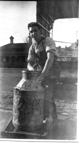 Port Melbourne Historical & Preservation Society
Photograph - William Raeburn Stuart, Woodruff;s Dairy, Bridge Street, 1920
... Black & white photo of William Raeburn Stuart with a milk churn outside Woodruff's Dairy in Bridge Street taken around 1920 when he was about 16 years old & working with Woodruff's. House on corner of Bridge & Derham street in the background....Port Melbourne Historical & Preservation Society Port Melbourne Town Hall 333 Bay Street Port Melbourne melbourne business and traders - dairies william raeburn stuart Black & white photo of William Raeburn Stuart with a milk churn outside Woodruff's Dairy in Bridge Street taken around 1920 when he was about 16 years old & working with Woodruff's. House on corner of Bridge & Derham street in the background. ...Black & white photo of William Raeburn Stuart with a milk churn outside Woodruff's Dairy in Bridge Street taken around 1920 when he was about 16 years old & working with Woodruff's. House on corner of Bridge & Derham street in the background.business and traders - dairies, william raeburn stuart -
 Bendigo Historical Society Inc.
Document - BENDIGO POTTERY (EPSOM) PTY LTD
... History House 11 Mackenzie Street Bendigo goldfields DOCUMENT Names of bendigo pioneers Bendigo Pottery Bendigo Pottery (Epsom) Pty Ltd Mr W Derham Royal Doulton Clay Division of Humes Bendigo Institute of Technology National Gallery George Duncan Guthrie Sailing ship Washington Beehive shaped kilns Typed page on the history of the Bendigo Pottery (Epsom) Pty. ...Typed page on the history of the Bendigo Pottery (Epsom) Pty. Ltd. It tells the story of George Duncan Guthrie, his arrival in Australia, his travels in Australia and finally settling in Bendigo where he set up the Bendigo Pottery.document, names of bendigo pioneers, bendigo pottery, bendigo pottery (epsom) pty ltd, mr w derham, royal doulton, clay division of humes, bendigo institute of technology, national gallery, george duncan guthrie, sailing ship washington, beehive shaped kilns -
 Bendigo Historical Society Inc.
Document - VICTORIA HILL - MISCELLANEOUS NOTES ON VICTORIA HILL
... History House 11 Mackenzie Street Bendigo goldfields DOCUMENT Gold victoria hill Victoria Hill Miscellaneous Notes on Victoria Hill Old Chum Shaft Ballerstedts First Open Cut Mine Workers' Wages Father Stockdale Rotary Club of Bendigo South Bradmill Bendigo Creek Shamrock Shaft Central Deborah Gold Mine Girton College Horwood's Foundry Sacred Heart Cathedral Lansell's Big 180 Flying Fox at Cent Blue Len Bennet Wesley Methodist Church St Johns Presbyterian Church All Saints Pro Cathedral Mr Derham National Trust Day Bendigo Potery H Biggs Clark Jeffrey City Council B & D T A Handwritten notes mentioning sign posts at Victoria Hill, Mine Workers' Wages, a note asking Father Stockdale if it would be possible to type a copy of the 'History of the Victoria Hill' for Rotary Club of Bendigo South', Notes on the Sacred Heart Cathedral and mentions The Wesley Methodist and St Johns Presbyterian Churches and All Saints Pro Cathedral, Bradmill, Bendigo Creek, Shamrock Shaft, Central Deborah Gold Mine, Girton College, Horwood's Foundry and the History We Have. ...Handwritten notes mentioning sign posts at Victoria Hill, Mine Workers' Wages, a note asking Father Stockdale if it would be possible to type a copy of the 'History of the Victoria Hill' for Rotary Club of Bendigo South', Notes on the Sacred Heart Cathedral and mentions The Wesley Methodist and St Johns Presbyterian Churches and All Saints Pro Cathedral, Bradmill, Bendigo Creek, Shamrock Shaft, Central Deborah Gold Mine, Girton College, Horwood's Foundry and the History We Have.document, gold, victoria hill, victoria hill, miscellaneous notes on victoria hill, old chum shaft, ballerstedts first open cut, mine workers' wages, father stockdale, rotary club of bendigo south, bradmill, bendigo creek, shamrock shaft, central deborah, gold mine, girton college, horwood's foundry, sacred heart cathedral, lansell's big 180, flying fox at cent blue, len bennet, wesley methodist church, st johns presbyterian church, all saints pro cathedral, mr derham, national trust day, bendigo potery, h biggs, clark jeffrey, city council b & d t a -
 Bendigo Historical Society Inc.
Document - VICTORIA HILL - RECOMMENDATIONS FOR VICTORIA HILL
... House... Bendigo Pottery... Mr Derham...History House 11 Mackenzie Street Bendigo goldfields BHS Collection DOCUMENT Victoria Hill Recommendations for Victoria Hill North Old Chum Ballerstedt's Rich 24 Yard Claim Floyds Battery Lansell's Big 180 The Bendigonian 26/1/1899 2/2/1899 20/4/1899 11/5/1899 10/8/1899 14/9/1899 Shamrock Mine Undershot Waterwheel at Diamond Hill Phillips Crushing Battery Mr Ballerstedt's Crushing Battery Thompson's Foundry Shenandoah Mine Koch's Pioneer Mine New Chum Railway Mine Fortuna Hustlers G M Co Bendigo New Chum Railway St Mungo Lady Barkly Catherine Reef New Moon Rae's Open Cut Old Court House Eaglehawk Police Barracks Vic Wodetzki Joss House Central Deborah Central Nell Gwynne Mr Harold Curnow Bendigo Branch Royal Historical Society Victoria Mrs Kingerlee Felicity Kingerlee Mr H Biggs City Council Rotary Club of Bendigo South White Hills Cemetry Chinese Joss House Bendigo Pottery Mr Derham Reservoir High Princess Theatre A N A Hall Mr Hattam Col. ...BHS CollectionHandwritten notes on recommendations for cleaning up and signposting Victoria Hill. Also contains list of photos from the Bendigonian of 1899. List of photos: Shamrock Mine, Undershot Water Wheel at Diamond Hill for Phillips Crushing Battery. Mr. Ballerstedt's Crushing Battery at Victoria Hill, Thompson's Foundry at Castlemaine, Machinery made for Bendigo Mines, Air Compressor at Shenandoah Mine, Winding Engine at Koch's Pioneer Mine, Poppet Legs at Koch's Pioneer Mine, Air Compressor at New Chum Railway Mine, Fortune Hustlers G M Co Bendigo View of Mine, Winding Plant and Afternoon Shift and Underground Work in the New Chum Railway. Also mentioned are notes on Machinery made by Thompsons. Also, a carbon copy of Annual Report to Bendigo Branch Royal Historical Society, Victoria 1/7/71. Mentioned in the Report are: Historical Ball, The Central Deborah, Victoria Hill, Tours and Society Business. Albert Richardson document?document, victoria hill, recommendations for victoria hill, north old chum, ballerstedt's rich 24 yard claim, floyds battery lansell's big 180, the bendigonian 26/1/1899, 2/2/1899, 20/4/1899, 11/5/1899, 10/8/1899, 14/9/1899, shamrock mine, undershot waterwheel at diamond hill, phillips crushing battery, mr ballerstedt's crushing battery, thompson's foundry, shenandoah mine, koch's pioneer mine, new chum railway mine, fortuna hustlers g m co bendigo, new chum railway, st mungo lady barkly, catherine reef, new moon, rae's open cut, old court house eaglehawk, police barracks, vic wodetzki, joss house, central deborah, central nell gwynne, mr harold curnow, bendigo branch royal historical society victoria, mrs kingerlee, felicity kingerlee, mr h biggs, city council, rotary club of bendigo south, white hills cemetry, chinese joss house, bendigo pottery, mr derham, reservoir high, princess theatre, a n a hall, mr hattam, col. sprenger, survey corps, a richardson -
 Bendigo Historical Society Inc.
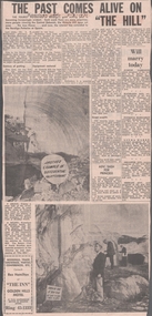
Newspaper - VICTORIA HILL - VICTORIA HILL NEWSPAPER ARTICLE
... House... Bendigo Potteries... Mr A E Richardson... Bendigo Historical Society... Mr J Hattam... Reservoir High School... Mr W J Derham...History House 11 Mackenzie Street Bendigo goldfields NEWSPAPER Bendigo advertiser Victoria Hill Victoria Hill Newspaper Article Central Deborah Victoria Hill Open Cut Joss House Bendigo Potteries Mr A E Richardson Bendigo Historical Society Mr J Hattam Reservoir High School Mr W J Derham Rotary Club of Bendigo South Bendigo and District Tourist Association Victoria Quartz Mine George Lansell's Big 180 Theodore Ballerstedt Goldmines Hotel Two copies of newspaper articles titled ''The Past Comes Alive on 'The Hill'' from the Bendigo Advertiser dated 3/7/1971. ...Two copies of newspaper articles titled ''The Past Comes Alive on 'The Hill'' from the Bendigo Advertiser dated 3/7/1971. Some history, a guided tour by two busloads of students and some plans are mentioned in the article. There are also two photos in the article. In one photo three Rotarians of Bendigo South, Mr. Vic Wodetski, Mr. Jack Bright and Mr. A. E. Richardson are inspecting some of the concentric rings of iron oxide and the quartz spur running through the centre of the outcrop on Victoria Hill. In the other photo Mr. jack Bright is looking at the natural curves of colour in the stone of Victoria Hill.newspaper, bendigo advertiser, victoria hill, victoria hill newspaper article, central deborah, victoria hill open cut, joss house, bendigo potteries, mr a e richardson, bendigo historical society, mr j hattam, reservoir high school, mr w j derham, rotary club of bendigo south, bendigo and district tourist association, victoria quartz mine, george lansell's big 180, theodore ballerstedt, goldmines hotel -
 Sunshine and District Historical Society Incorporated
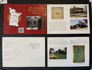
Pamphlet - Snapshots of Sunshine and District, Sunshine & District Historical Societh et al
... Nettlefolds Coronation Celebrations|Gardens of Sunshine - Sunshine Gardens & Lynch's Gardens|Sunshine Street Markets|Sunshine Post Offices|Headlie Shipard Taylor|Sunshine Town Hall|Sunshine Heights Primary School|Charles Pippett and the Russell Street Gates|Historic Houses of Sunshine|Hunt Club Community Arts Centre|The Derham Family|Sunshine Picture Theatre Progressin Through The Years|Sunshine Society Dispensary Sun Crescent Sunshine|Sunshine Municipal Offices|Victoria University and Sunshine|Sunshine RSL (Returned & Services League)|Sunshine Railway Disater Plaque...Small book published by the Snapshots of Sunshine and District Historical Society Sunshine History Nettlefolds Coronation Celebrations|Gardens of Sunshine - Sunshine Gardens & Lynch's Gardens|Sunshine Street Markets|Sunshine Post Offices|Headlie Shipard Taylor|Sunshine Town Hall|Sunshine Heights Primary School|Charles Pippett and the Russell Street Gates|Historic Houses of Sunshine|Hunt Club Community Arts Centre|The Derham Family|Sunshine Picture Theatre Progressin Through The Years|Sunshine Society Dispensary Sun Crescent Sunshine|Sunshine Municipal Offices|Victoria University and Sunshine|Sunshine RSL (Returned & Services League)|Sunshine Railway Disater Plaque Book containing images and text about the history of Sunshine Pamphlet Snapshots of Sunshine and District Sunshine & District Historical Societh Joan Nathan Ken Nathan Melchior Bajada ...Book containing images and text about the history of Sunshinesunshine, history -
![Harry A. Derham, Mayor [of Kew] 1891-2](/media/collectors/550653872162f11fb04854aa/items/59228feed0cf110e040ad5b1/item-media/5c1ec51921eabf0988cd79a3/item-fit-380x285.jpg?cb=6) Kew Historical Society Inc
Kew Historical Society IncPhotograph, J E Barnes, Harry A. Derham, Mayor [of Kew] 1891-2, c.1906
... housed in their original frames. This portrait is one of a series of mounted and framed photographic portraits of mayors and town clerks of the former Borough, Town and City of Kew. The portraits were transferred by the City of Kew to the Kew Historical Society in March 1989. A Significance Assessment in 2018, funded by the National Library of Australia confirmed the historic, and often artistic significance of the series. photographers - kew (vic) - josiah earl barnes cr. harry a. derham mayors of kew (vic) Kew (Vic.) — municipal collection Harry A. ...Kew achieved independence from the Boroondara Roads Board in 1860. As a new municipality, its first three leaders were designated as chairmen. On becoming a borough in 1863, its leaders were identified as mayors. The earliest photographs date from ca.1906, when the Town of Kew commissioned the noted local photographer Josiah E Barnes to produce standardised portraits of former mayors to be displayed in the Mayoral Chamber of the Town Hall. The collection also includes photographs by other well-known photographic studios such as Burlington Studios, Melba – Melbourne, Stuart Tompkins, Spencer Shier and Talma & Co. The majority of mounts identify the photographer. Eighty photographs are housed in their original frames.This portrait is one of a series of mounted and framed photographic portraits of mayors and town clerks of the former Borough, Town and City of Kew. The portraits were transferred by the City of Kew to the Kew Historical Society in March 1989. A Significance Assessment in 2018, funded by the National Library of Australia confirmed the historic, and often artistic significance of the series.Unframed portrait of Cr. Harry A. Derham, Mayor of Kew 1891-2. The mounting and framing of the photograph follows a typical layout or style in that each is framed in dark wood, glazed, and laid down on an inscribed board. The inscription identifies the name of the mayor and the year/s that he/she served.Harry A. Derham, Mayor [of Kew] 1891-2photographers - kew (vic) - josiah earl barnes, cr. harry a. derham, mayors of kew (vic), kew (vic.) — municipal collection -
 Kew Historical Society Inc
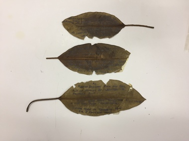
Plant specimen, Dorothy Rogers, Inscribed Moreton Bay Fig Leaves, Hawthorn (Vic), c.1960s
... Kew Historical Society Inc Kew Court House 188 High Street Kew melbourne Collected by the historian Dorothy Rogers denham street - hawthorn (vic) palmer's punt invergowrie - hawthorn 1934 flood - melbourne - hawthorn (vic) 1974.0010.1 "Moreton Bay fig leaf from old tree foot of Derham St Haw - vicinity Palmer's Punt until 1934 flood & hut for Punt passengers was still there. ...Collected by the historian Dorothy RogersDried Moreton Bay fig leaves from the vicinity of Palmer's Punt near Denham Street Hawthorn. Each leaf was inscribed by the historian Dorothy Rogers (sic) before 1973. The leaves are brittle and undated, with the text difficult to decipher. 1974.0010.1 "Moreton Bay fig leaf from old tree foot of Derham St Haw - vicinity Palmer's Punt until 1934 flood & hut for Punt passengers was still there. KH-355." 1974.0010.2 "Moreton Bay fig leaf from old tree foot of Denham St haw - vicinity Palmer's Punt until 1934 flood hut for punt passengers still existed there. A canoe tree in garden from Sir J. Palmer's land. KH-355." 1974.0010.3 "Moreton Bay fig leaf from old tree foot of Denham St leading to Palmer's Punt until 1934 flood there was still there a hut for punt passengers. Canoe tree in gardens from Sir J. Palmer's land. KH-355."denham street - hawthorn (vic), palmer's punt, invergowrie - hawthorn, 1934 flood - melbourne - hawthorn (vic) -
Kew Historical Society Inc
Archive (Series) - Subject File, DERHAM Family, 1958
... Kew Historical Society Inc Kew Court House 188 High Street Kew melbourne Since its foundation in 1958, members of the Kew Historical Society have been compiling and storing information about subjects relating to the history of Kew and its environs, of which this file is an example. Typically files will contain primary and secondary sources. derham ...Various partiesReference, Research, InformationSecondary Values (KHS Imposed Order)Subject file containing sundry copies of notes and references for the Derham Family who at one stage lived at 21 Barry Street. Frederick Derham was most notably MLA for Sandridge in the Victorian Parliament for 1883-92.derham familyderham family