Showing 105 items matching "diamond creek - maps"
-
 Greensborough Historical Society
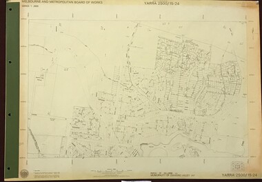
Map, Melbourne and Metropolitan Board of Works. Survey Division, MMBW, Yarra 2500 / 15.24. Diamond Creek, Grassy Flat Road, 1978_02
... ...diamond creek - maps...Yarra 2500 [base map] 15.24. Diamond Creek, Grassy Flat Road. Parish of Nillumbik 3310. ...Features include the Diamond Creek, Nillumbik Park and Diamond Creek Reservoir. mmbw melbourne and metropolitan board of works diamond creek - maps shire of diamond valley MMBW Map in 1:2500 [scale] series. ...Melbourne and Metropolitan Board of Works. Yarra 2500 [base map] 15.24. Diamond Creek, Grassy Flat Road. Parish of Nillumbik 3310. Municipality of Diamond Valley 257. Prominent streets include: Everleigh Drive, Broad Gully Road and Clyde Street. Features include the Diamond Creek, Nillumbik Park and Diamond Creek Reservoir.MMBW Map in 1:2500 [scale] series. Cream parchment with green tape reinforcing on edges and punched holes on left edge.mmbw, melbourne and metropolitan board of works, diamond creek - maps, shire of diamond valley -
 Greensborough Historical Society
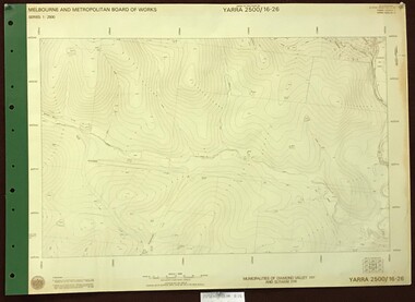
Map, Melbourne and Metropolitan Board of Works. Survey Division, MMBW, Yarra 2500 / 16.26. Diamond Creek, Broadgully Road, 1978_07
... ...diamond creek - maps...Yarra 2500 [base map] 16.26. Diamond Creek, Broad Gully Road. Municipalities of Diamond Valley 257 and Eltham 238. ...Features include the Diamond Creek. mmbw melbourne and metropolitan board of works shire of diamond valley diamond creek - maps MMBW Map in 1:2500 [scale] series. ...Melbourne and Metropolitan Board of Works. Yarra 2500 [base map] 16.26. Diamond Creek, Broad Gully Road. Municipalities of Diamond Valley 257 and Eltham 238. Prominent streets include: Wadeson Road, Broad Gully Road and Glenhaven Road. Features include the Diamond Creek.MMBW Map in 1:2500 [scale] series. Cream parchment with green tape reinforcing on edges and punched holes on left edge.mmbw, melbourne and metropolitan board of works, shire of diamond valley, diamond creek - maps -
 Greensborough Historical Society
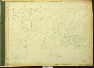
Map, Melbourne and Metropolitan Board of Works. Survey Division, MMBW, Yarra 2500 / 15.23. Diamond Creek Reserve, 1978_02
... ...diamond creek - maps...map] 15.23. Hurstbridge. Municipality of Diamond Valley 257. Prominent streets include: Challenger Street, James Cook Drive and Ryans Road / Main Street. Features include the Diamond Creek... and Diamond Creek Reserve. mmbw melbourne and metropolitan board of works shire of diamond valley diamond creek - maps MMBW Map in 1:2500 [scale] series. ...Melbourne and Metropolitan Board of Works. Yarra 2500 [base map] 15.23. Hurstbridge. Municipality of Diamond Valley 257. Prominent streets include: Challenger Street, James Cook Drive and Ryans Road / Main Street. Features include the Diamond Creek and Diamond Creek Reserve.MMBW Map in 1:2500 [scale] series. Cream parchment with green tape reinforcing on edges and punched holes on left edge.mmbw, melbourne and metropolitan board of works, shire of diamond valley, diamond creek - maps -
 Greensborough Historical Society
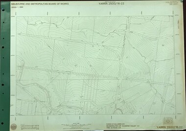
Map, Melbourne and Metropolitan Board of Works. Survey Division, MMBW, Yarra 2500 / 16.22. Research, 1979_05
... ...diamond creek - maps...map] 16-22. Research. Parish of Nillumbik 3310. Municipalities of Diamond Valley 257 and Eltham 238. Prominent streets include: Orme Road and Allendale Road. mmbw melbourne and metropolitan board of works shire of diamond valley diamond creek - maps MMBW Map in 1:2500 [scale] series. ...Melbourne and Metropolitan Board of Works. Yarra 2500 [base map] 16-22. Research. Parish of Nillumbik 3310. Municipalities of Diamond Valley 257 and Eltham 238. Prominent streets include: Orme Road and Allendale Road. MMBW Map in 1:2500 [scale] series. Cream parchment with green tape reinforcing on edges and punched holes on left edge.mmbw, melbourne and metropolitan board of works, shire of diamond valley, diamond creek - maps -
 Greensborough Historical Society
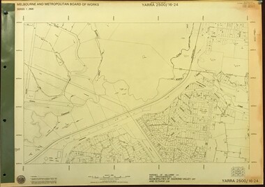
Map, Melbourne and Metropolitan Board of Works. Survey Division, MMBW, Yarra 2500 / 16.24. Northern Diamond Creek and Wattle Glen, 1978_02
... ...diamond creek - maps...Yarra 2500 [base map] 16-24. Northern Diamond Creek and Wattle Glen. Parishes of Nillumbik 3310 and Greensborough 2724. ...Includes Wattle Glen Station. mmbw melbourne and metropolitan board of works shire of diamond valley wattle glen - maps diamond creek - maps MMBW Map in 1:2500 [scale] series. ...Melbourne and Metropolitan Board of Works. Yarra 2500 [base map] 16-24. Northern Diamond Creek and Wattle Glen. Parishes of Nillumbik 3310 and Greensborough 2724. Municipalities of Diamond Valley 257 and Eltham 238. Prominent streets include: Hurstbridge Road, and Reynolds Road. Includes Wattle Glen Station.MMBW Map in 1:2500 [scale] series. Cream parchment with green tape reinforcing on edges and punched holes on left edge.mmbw, melbourne and metropolitan board of works, shire of diamond valley, wattle glen - maps, diamond creek - maps -
 Greensborough Historical Society
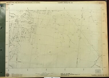
Map, Melbourne and Metropolitan Board of Works. Survey Division, MMBW, Yarra 2500 / 16.23. Diamond Creek, 1978_02
... ...diamond creek - maps...Yarra 2500 [base map] 16-23. Diamond Creek. Parish of Nillumbik 3310. ...MMBW, Yarra 2500 / 16.23. Diamond Creek. Map Map Melbourne and Metropolitan Board of Works. ...Melbourne and Metropolitan Board of Works. Yarra 2500 [base map] 16-23. Diamond Creek. Parish of Nillumbik 3310. Municipalities of Diamond Valley 257 and Eltham 238. Prominent streets include: Phipps Crescent, Bishop Avenue, and Reynolds Road. Includes the former Diamond Creek Technical School.MMBW Map in 1:2500 [scale] series. Cream parchment with green tape reinforcing on edges and punched holes on left edge.mmbw, melbourne and metropolitan board of works, shire of diamond valley, diamond creek - maps -
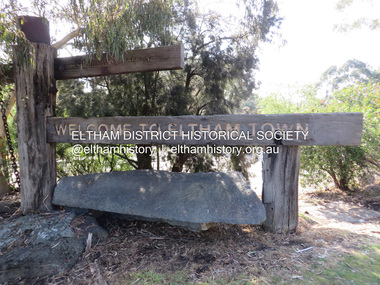
 Eltham District Historical Society Inc
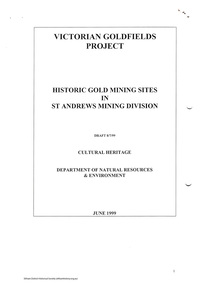
Folder, Victorian Goldfields Project: Historic gold mining sites in St Andrews mining division, 1999
... Includes information on the Warrandyte Goldfield and the Caledonia Goldfield, Queenstown (now known as St Andrews), One Tree Hill, Kingston (now known as Panton Hill), Kangaroo Grounds, You You Hill, Kingstown, South Morang, Nillumbik, (now known as Diamond Creek), Steele's Creek, Yarrambet and Kinglake. Photocopy of map headed: Location of mines and reefs from Geological survey of Victoria, Yan Yean with the Diamond Creek prominant on the map. no date...Includes information on the Warrandyte Goldfield and the Caledonia Goldfield, Queenstown (now known as St Andrews), One Tree Hill, Kingston (now known as Panton Hill), Kangaroo Grounds, You You Hill, Kingstown, South Morang, Nillumbik, (now known as Diamond Creek), Steele's Creek, Yarrambet and Kinglake. Photocopy of map headed: Location of mines and reefs from Geological survey of Victoria, Yan Yean with the Diamond Creek prominant on the map. no date caledonian gold fields, caledonina gold field, david bannear, gold mining, harry gilham collection, queenstown, st andrews, warrandyte goldfield 35 page report with map and print out of cover letter (email form) from donor Victorian Goldfields Project: Historic gold mining sites in St Andrews mining division Folder ...Heritage site report and gazetteer by David Bannear, head consultant for archealogy for the Department of Natural Resources and Environment. Includes information on the Warrandyte Goldfield and the Caledonia Goldfield, Queenstown (now known as St Andrews), One Tree Hill, Kingston (now known as Panton Hill), Kangaroo Grounds, You You Hill, Kingstown, South Morang, Nillumbik, (now known as Diamond Creek), Steele's Creek, Yarrambet and Kinglake. Photocopy of map headed: Location of mines and reefs from Geological survey of Victoria, Yan Yean with the Diamond Creek prominant on the map. no date35 page report with map and print out of cover letter (email form) from donorcaledonian gold fields, caledonina gold field, david bannear, gold mining, harry gilham collection, queenstown, st andrews, warrandyte goldfield -
 Eltham District Historical Society Inc
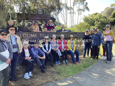
Photograph, Fay Bridge, EDHS Heritage Walk: Shillinglaw Farm, Eltham, 2 September 2023
... Diamond Creek trail behind Andrew Park. The actual farm boundary went past the creek and further up the hill. The original farm comprised lot 90 of Holloway’s 1851 subdivision of Little Eltham. Its area was 30 acres lying east of the Diamond Creek and north of Henry Street. A number of stops were made to look at maps...Diamond Creek trail behind Andrew Park. The actual farm boundary went past the creek and further up the hill. The original farm comprised lot 90 of Holloway’s 1851 subdivision of Little Eltham. Its area was 30 acres lying east of the Diamond Creek and north of Henry Street. A number of stops were made to look at maps ...On Saturday September 2, 2023, Russell Yeoman led a group of 22 society members and interested others on a walk following trhe bounadries of the original Shillingalw farm. Commencing at the corner of Panther Place and Library Place, we proceeded up to Shillinglaw Cafe then the Shillinglaw trees at the former Eltham Shire Office site then along Main Road to the fire station then throughh St Laurence Lane and uinder the railway line , along Diamond Street then return via the Diamond Creek trail behind Andrew Park. The actual farm boundary went past the creek and further up the hill. The original farm comprised lot 90 of Holloway’s 1851 subdivision of Little Eltham. Its area was 30 acres lying east of the Diamond Creek and north of Henry Street. A number of stops were made to look at maps and early photos illustrating the gradual reduction of the farm area and the early history of the railway and other community uses, that occupied parts of the site.fay bridge collection, 2023-09-02, activities, eltham, eltham district historical society, heritage excursion, shillinglaw farm -
 Eltham District Historical Society Inc
Photograph, Liz Pidgeon, EDHS Heritage Walk: Shillinglaw Farm, Eltham, 2 September 2023
... Diamond Creek trail behind Andrew Park. The actual farm boundary went past the creek and further up the hill. The original farm comprised lot 90 of Holloway’s 1851 subdivision of Little Eltham. Its area was 30 acres lying east of the Diamond Creek and north of Henry Street. A number of stops were made to look at maps...Diamond Creek trail behind Andrew Park. The actual farm boundary went past the creek and further up the hill. The original farm comprised lot 90 of Holloway’s 1851 subdivision of Little Eltham. Its area was 30 acres lying east of the Diamond Creek and north of Henry Street. A number of stops were made to look at maps ...On Saturday September 2, 2023, Russell Yeoman led a group of 22 society members and interested others on a walk following trhe bounadries of the original Shillingalw farm. Commencing at the corner of Panther Place and Library Place, we proceeded up to Shillinglaw Cafe then the Shillinglaw trees at the former Eltham Shire Office site then along Main Road to the fire station then throughh St Laurence Lane and uinder the railway line , along Diamond Street then return via the Diamond Creek trail behind Andrew Park. The actual farm boundary went past the creek and further up the hill. The original farm comprised lot 90 of Holloway’s 1851 subdivision of Little Eltham. Its area was 30 acres lying east of the Diamond Creek and north of Henry Street. A number of stops were made to look at maps and early photos illustrating the gradual reduction of the farm area and the early history of the railway and other community uses, that occupied parts of the site.2023-09-02, activities, eltham, eltham district historical society, heritage excursion, shillinglaw farm, 895 main road, amplifon, andrew park, andrew pocket park, arthur street, bar de tapas, barber shop, barry plant estate agent, blockbuster, bus depot, car park, carparks, central park, cleaver & co hair, commonwealth bank, crust pizza, divine bridal, dr ash constance, dudley street, eltham book shop, eltham convenience store, eltham fire station, eltham library, eltham newsagency, eltham optical, eltham railway station, eltham shops, fay bridge, fire bell, flagpole, flight centre, grill'd, information sign, iso chook, jellis craig estate agent, judge book village, kebab nation, kx pilates, la zanyas, liquorland, little drop of poison, lorraine jones & associates solicitors, luck street, machan indian restaurant, main road, mecho en mexico, missing gorilla, morrison kleeman real estate, pavilion menswear, platform 3095, playtherapy melbourne, pryor street, ray white real estate, restaurants, sage bulk whole foods, shillinglaw trees, sign, snap fitness, southern cross medical imaging, specsavers, st laurence lane, st vincents care service, thompson's pharmacy, todaro, united service station, vyve body & skin, welcome to eltham town, westpac bank, yang's kitchen, youth road -
 Eltham District Historical Society Inc
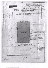
Document - Photocopy, Survey Fleld Notes of Part of Crown Portion 13, Section 4 at Eltham, Parish of Nillumbik, County of Evelyn, 1902-1903
... Diamond Creek (Creek)...Diamond Street...Eltham...Eltham Railway Station...henry street...Main Road...silver street...Survey Plan...Vine street...Application 33777...Map...Eltham District Historical Society Inc 728 Main Rd Eltham melbourne Main Road, Henry Street to Diamond Street; Silver Street to Bible Street Application No. 033777 1902 1903 Arthur Street Bible Street Bird street Diamond Creek (Creek) Diamond Street Eltham Eltham Railway Station henry street Main Road silver street Survey Plan Vine street Application 33777 Map A4 printouts, 7 pages Survey Fleld Notes of Part of Crown Portion 13, Section 4 at Eltham, Parish of Nillumbik, County of Evelyn Document Photocopy ...Main Road, Henry Street to Diamond Street; Silver Street to Bible Street Application No. 0337771902, 1903, arthur street, bible street, bird street, diamond creek (creek), diamond street, eltham, eltham railway station, henry street, main road, silver street, survey plan, vine street, application 33777, map -
 Eltham District Historical Society Inc
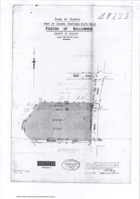
Document - Photocopy, Survey Fleld Notes of Part of Crown Portions 12 & 13, Section 4 at Eltham, Parish of Nillumbik, County of Evelyn, 6 May 1929
... Diamond Creek (Creek)...Eltham...Main Road...Map...Diamond Creek, Swan Street Application 48223 P.N. Guy, Licensed Surveyor, 6 May 1929 Application 48223 Diamond Creek (Creek) Eltham Main Road Map Survey Plan Swan Street York Street A4 printouts, 2 pages Survey Fleld Notes of Part of Crown Portions 12 & 13, Section 4 at Eltham, Parish of Nillumbik, County of Evelyn Document Photocopy ...Portion of land bounded by: Main Road, York Street, Diamond Creek, Swan Street Application 48223 P.N. Guy, Licensed Surveyor, 6 May 1929application 48223, diamond creek (creek), eltham, main road, map, survey plan, swan street, york street -
 Eltham District Historical Society Inc
Document - Folder, Panton, Joseph Anderson
... Creek, Heidelberg, Geelong and Melbourne. He owned land on the Yarra River and Panton Hill is named for him. Contents Map: J A Panton's landholding with surrounding landholders. Printout and photocopy: Panton, Joseph Anderson, Australian Dictionary of Biography entry. Notes: Joseph Anderson Panton, brief biographical notes. Research Enquiry Form: Vivienne Worthington, seeking sources of information regarding Joseph Anderson Panton, 14 June 2017. Email and associated documents: Michael Kennedy seeking assistance of Eltham Gateway Action Group regarding proposed felling of manna gum tree near bridge across Diamond...Creek, Heidelberg, Geelong and Melbourne. He owned land on the Yarra River and Panton Hill is named for him. Contents Map: J A Panton's landholding with surrounding landholders. Printout and photocopy: Panton, Joseph Anderson, Australian Dictionary of Biography entry. Notes: Joseph Anderson Panton, brief biographical notes. Research Enquiry Form: Vivienne Worthington, seeking sources of information regarding Joseph Anderson Panton, 14 June 2017. Email and associated documents: Michael Kennedy seeking assistance of Eltham Gateway Action Group regarding proposed felling of manna gum tree near bridge across Diamond ...Joseph Anderson Panton (1831-1913) came from Scotland to Australia in 1851. In Bendigo, he was appointed assistant gold commissioner 1852 and senior commissioner 1854. Over the years, he served as magistrate at Jamieson-Wood's Point, Anderson's Creek, Heidelberg, Geelong and Melbourne. He owned land on the Yarra River and Panton Hill is named for him. Contents Map: J A Panton's landholding with surrounding landholders. Printout and photocopy: Panton, Joseph Anderson, Australian Dictionary of Biography entry. Notes: Joseph Anderson Panton, brief biographical notes. Research Enquiry Form: Vivienne Worthington, seeking sources of information regarding Joseph Anderson Panton, 14 June 2017. Email and associated documents: Michael Kennedy seeking assistance of Eltham Gateway Action Group regarding proposed felling of manna gum tree near bridge across Diamond Creek, on land once held by Joseph Anderson Panton. Newspaper article: "Historic painting might be lost to Victoria," The Age, 22 October 1985. Painting by Joseph Anderson Panton of Captain William Lonsdale's house, Victoria's first Government House, to be in forthcoming auction. Newspaper clippings, A4 photocopies, etcjoseph anderson panton, william b burnley, w walsh, r hall, r a davidson, j orford, b speers, a speers, william bell, t baillie, d mcloughlin, t prior, g e hodgkins, n rodda, w r belcher, g d boursiquot, j p imley, t b darling, h g jones, t sweny, r lane, w gordon, a e morris, d w thring, j carfrae, thomas sweeney, michael kennedy, vivienne worthington, william crozier, j frank, p carrucan, panton hill -
 Eltham District Historical Society Inc
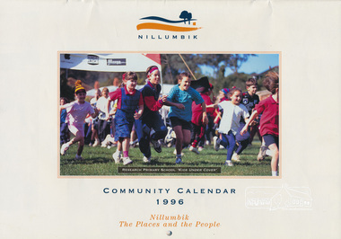
Calendar, Nillumbik Community Calendar 1996: Nillumbik The Places and the People, 1995
... diamond creek trail,yarrambat golf course,sugar loaf reservoir,map...One of a series of calendars which the Shire of Eltham and the Shire of Nillumbik published annually Photography by Graham Hosking Photography. calendar,1996,shire of nillumbik,research primary school,eltham north adventure playground,edendale gateway,tony trembath,eltham leisure centre,diamond valley railway,kangaroo ground pony club,eltham community and reception centre,eltham community centre,shire of nillumbik,swimming pool,yarra river, diamond creek trail,yarrambat golf course,sugar loaf reservoir,map Monthly calendar printed in landscape mode, with feature photograph and template of dates for each of the 12 months presented. ...Community Project. One of a series of calendars which the Shire of Eltham and the Shire of Nillumbik published annually Photography by Graham Hosking Photography. Monthly calendar printed in landscape mode, with feature photograph and template of dates for each of the 12 months presented. Includes advertisements. Back of the calendar includes a list of emergency numbers.calendar,1996,shire of nillumbik,research primary school,eltham north adventure playground,edendale gateway,tony trembath,eltham leisure centre,diamond valley railway,kangaroo ground pony club,eltham community and reception centre,eltham community centre,shire of nillumbik,swimming pool,yarra river,, diamond creek trail,yarrambat golf course,sugar loaf reservoir,map -
 Eltham District Historical Society Inc
Photograph, Tess Justine (Nillumbik Shire Council), Murray's Bridge over the Diamond Creek, Eltham North, 19 Feb 2022
... Diamond Creek). Perhaps this may have been one of the motivators for Murray, who really knows? Knowing when mining operations ceased on his land and how that fits the overall timeline would be useful but at the time the bridge was built, local gold production was minimal at best. The known facts are: • The railway line came to Eltham in 1902. • The extension of the railway from Eltham to Hurstbridge was constructed in 1912 so no railway line even existed through Murray's property until 1912 and the Victorian Railways maps at the time show no such siding on Murray’s property. • In 1923 a new company was formed in anticipation of the old Diamond Creek Gold Mine being re-opened. ...Diamond Creek). Perhaps this may have been one of the motivators for Murray, who really knows? Knowing when mining operations ceased on his land and how that fits the overall timeline would be useful but at the time the bridge was built, local gold production was minimal at best. The known facts are: • The railway line came to Eltham in 1902. • The extension of the railway from Eltham to Hurstbridge was constructed in 1912 so no railway line even existed through Murray's property until 1912 and the Victorian Railways maps at the time show no such siding on Murray’s property. • In 1923 a new company was formed in anticipation of the old Diamond Creek Gold Mine being re-opened. ...Murray's Bridge over the Diamond Creek on the Diamond Creek Trail just prior to demolition and replacement with a new steel bridge. Heritage advice obtained by Nillumbik Shire Council, following a suggestion by the Eltham District Historical Society (EDHS), is that the original bridge appears to have been a simplified version of the Country Roads Board’s (CRB) standard timber bridge design of the early-to-mid 1920s. In c1990 Murray’s bridge was renovated with three recycled steel girders as part of a bike/pedestrian path in the reserve. During these alterations many parts of the bridge were removed, and some were replaced. Heritage advice indicates the condition of Murray’s bridge is poor. The remaining original parts are all in poor condition, with severe weathering, splitting and rot, especially to the stringers retained on the bridge. Heritage advice is that Murray’s Bridge does not have sufficient significance in the cultural history of the Nillumbik area to warrant inclusion in the Nillumbik Shire Heritage Overlay and also does not have sufficient significance as a rare survivor to warrant inclusion in the Nillumbik Shire Heritage Overlay. There are no indications in the historical record that this site was individually important to the cultural history of this area. EDHS is comfortable with the heritage advice provided to Council and has worked closely on this project with Council. EDHS has suggested some of the removed timbers be used in the vicinity of the bridge for landscaping and possibly seating, so as to retain these remnants close to the site of the original bridge, which is the last old timber bridge along the lower reaches of the Diamond Creek. Mary (Sweeney) Murray and John Wright Murray selected 80 acres, Lot C Section 16 and Lot 5 Section 17 Parish of Nillumbik, under an occupation license in 1866. John died in 1867 and freehold was granted to his son John in 1873. The farm was known as ‘Laurel Hill’. John Junior was an Eltham Shire councillor and sometime president from 1887 up until 1897. He added Lot A Section 16 to the farm in ca1888. John and his younger brother James arranged to rent/purchase Lot B Section 17, across Diamond Creek to the west, in ca1900. It appears that John and James farmed separately for a few years, with a new homestead built for James ad family on the high point of Lot B Section 17 in ca1910. John sold off Lot 5 Section 17 in 1912. When John died in 1912 James took over the land on both sides of the Diamond Creek. The old homestead on the west side of the Creek disappeared. A farm bridge over Diamond Creek from this period may have been located close to the northern boundary of the farm. John Langlands, owner of the farm known as ‘Ihurst’ on the west side of Diamond Creek to the south of the Murray’s land, died in 1907. In 1909 his land was then subdivided into 100 lots to become the ‘Glen Park Estate’. Other similar subdivisions of nineteenth century farms around Eltham in this period included the ‘Franktonia (or Beard’s) Estate’ to the northeast and ‘Bonsack’s Estate’ between Eltham and Greensborough. Soon after the opening of the railway extension line from Eltham to Hurstbridge in 1912, Glen Park and nearby residents including James Murray agitated for a railway station or siding to be located half-way between Eltham and Hurstbridge, so that the Glen Park residents who used the railway daily did not have to walk into the Eltham or Hurstbridge stations. Some believed Coleman’s Corner (opposite Edendale Farm) was an appropriate spot for the platform. James Murray was among those who thought the railway should be located on his land, closer to half-way between Eltham and Hurstbridge stations. The Railways Commissioners warned that the locals would have to fund these works themselves. The Glen Park Estate residents initially had difficulty accessing Eltham by road, with only an old low-level bridge over Diamond Creek at the south end of their estate. A new timber trestle bridge across the creek, now on Wattletree Road, was opened in 1915. Road access to the north was gained in 1927 when the new Murray’s Road, which crossed the Murray’s land, was built. Residents continued to agitate for a Glen Park station. By 1926 the Railways Commissioners’ preferred site was on the Murray’s land. They arranged an estimate of cost of a full-length platform. The estimate was too much for the locals, who in 1928 argued unsuccessfully for a shorter and hence cheaper platform. By 1929 Murray had agreed to donate the land, but the locals would still have to fund the works. Murray decided, unilaterally it would appear, to commence work on a timber trestle road bridge over Diamond Creek to link the new Murray Road to the proposed station. Late in 1929 he stopped work on the bridge, for reasons unknown, but started work again and completed the bridge in 1931. There is no further newspaper evidence of the campaign for the Glen Park station until 1939, when Murray and another local, Mr Maxwell, met the Railways Commissioner. The Glen Park locale now included 45 homes on the west side of the creek and 20 on the Eltham side. Most of the residents used the train every day. The Commissioner remained adamant that only a full-length platform could be built for safety reasons. It appears the campaign dissolved at this point. The increasing move to cars may have had an impact. There is no evidence of Murray’s bridge ever being connected to Murray’s Road, or of it having wide use for any purpose by locals. James Murray died in 1947 and the farm was taken over by his son James (Jim). Jim started to sell off parts of the farm in the 1980s, retaining a few acres around the ca1910 homestead and building a new house there. Recreation reserves were established along the creek. In ca1990 Murray’s bridge was renovated with steel girders as part of a bike/pedestrian path in the reserve. The old farmhouse was demolished in ca2014. * * * A theory posted on local community Facebook groups was that the bridge was built in the 1860s and was built to be more robust than was necessary for the movement of cows from one side of the creek to the other. It was suggested the robustness was necessary to support the weight of gold ore being transferred from a mine on Murray’s land to a railway siding near Murrays Bridge (presumably for transfer and processing at Diamond Creek). Perhaps this may have been one of the motivators for Murray, who really knows? Knowing when mining operations ceased on his land and how that fits the overall timeline would be useful but at the time the bridge was built, local gold production was minimal at best. The known facts are: • The railway line came to Eltham in 1902. • The extension of the railway from Eltham to Hurstbridge was constructed in 1912 so no railway line even existed through Murray's property until 1912 and the Victorian Railways maps at the time show no such siding on Murray’s property. • In 1923 a new company was formed in anticipation of the old Diamond Creek Gold Mine being re-opened. The mine had been previously closed and flooded. It was noted in the press at the time that the mine was within a mile of the railway. Nothing really came of this. • Construction of Murrays Bridge was commenced by James Murray in early 1929 in anticipation of a proposed flag station being nominated on his land, but work ceased shortly afterwards. The proposed flag station was commonly referred to as Glen Park as the residents of the Glen Park Estate wanted Option 1, located near them with the platform adjacent to Colemans corner. This was probably never going to fly as it was virtually in eyesight of Eltham station. Allandale Road was the third option, but the Commissioners' preferred option was No. 2 - on Murray's property. • The Railway Commissioners were not going to finance any such station and the works had to be funded by private landowners and residents, hence Murray investing in this himself. • Murray recommenced work two years later and finished his bridge in 1931 but unfortunately for him, the proposed flag station never eventuated. The bluestone siding you reference may well have been built by Murray as part of the proposed station platform. • Up until then, apart from the Main Road bridge, which was washed away in 1924, virtually all local crossings over the Diamond Creek were low lying bridges – Kaylocks Bridge at Brougham Street, Diamond Street bridge, Glen Park Road bridge. It is expected that Murray also had a low-lying bridge to connect his land either side of the creek. These were all washed away or severely damaged multiple times in the 1920s. Lessons were learnt, and Murrays Bridge appears to have been built in accordance with Country Road Board standards of the time. Flood damage was ongoing, and even more recently constructed raised bridges kept getting washed away, e.g., the new Wattle Tree Road bridge in 1958 just months after completion. Murray’s bridge was reinforced with steel some 30 years ago presumably to provide additional floodwater resistance, given the history of bridges disappearing in floodwaters. • In March 1932 it was reported in the Advertiser that there were still some prospectors operating around Eltham North who apart from further scarring the face of the earth over the previous two years had gained significant experience but little gold - hardly a driving factor for constructing a dedicated railway siding and bridge to transfer gold ore. It is far more probable that James Murray was hoping to have the railway station located on his property and invested his money by building the bridge to lead to it as well as a station platform. Had the station eventuated, it may well have driven up the value of his land for subdivision and new housing estates like the Glen Park Estate. That did not eventuate. Whilst the bridge was indeed old (90 years), the core structure being completed in 1931, it had been modified substantially from original and hence had no significant historic value – i.e., it was not a representative example of its type, construction, and age. Given that the bridge was not worthy of saving, the Eltham District Historical Society with Council’s support, and the Eltham Woodworkers group endeavoured to see what suitable sized timbers were salvageable to fabricate a commemorative seat. Unfortunately, the experts at the Woodworkers group were unable to salvage any suitable length/width timbers to fabricate the seat due to the presence of rot. Last remaining wooden trestle bridge on the Diamond Creek Trail just prior to demolition and replacementBorn digital image (27)diamond creek (creek), diamond creek trail, murrays bridge, ‘laurel hill’, john wright murray, mary (sweeney) murra, john murray jnr, james murray, john langlands, ‘ihurst’, ‘glen park estate’, beard's estate, franktonia, bonsack's estate, glen park estate, glen park railway station -
 Greensborough Historical Society
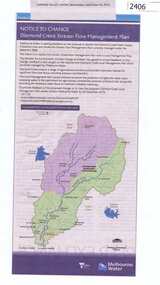
Newspaper Clipping, Diamond Creek stream flow management plan, 30/09/2015
... Greensborough Historical Society 34A Glenauburn Road Lower Plenty Lower Plenty melbourne In this Public Notice, Melbourne Water seeks feedback on the Diamond Creek Stream Flow Management Plan. diamond creek stream flow management plan melbourne water. News clipping, black text, colour map. ...In this Public Notice, Melbourne Water seeks feedback on the Diamond Creek Stream Flow Management Plan.News clipping, black text, colour map.diamond creek stream flow management plan, melbourne water. -
 Greensborough Historical Society
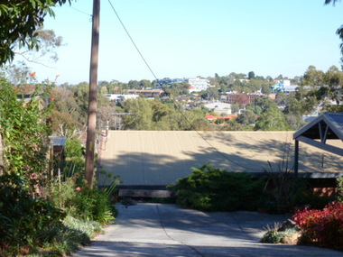
Photograph - Digital image, View of Greensborough from Delfin Crescent, 02/05/2013
... It was at this time also, that major works on Diamond Creek Road raised the level of the road facilitating the connection of Delfin Crescent with Diamond Creek Road. [Note: 'Medhurst Street was only listed on planning maps pre 1950 when the 'street' had no residents or development.]...It was at this time also, that major works on Diamond Creek Road raised the level of the road facilitating the connection of Delfin Crescent with Diamond Creek Road. [Note: 'Medhurst Street was only listed on planning maps pre 1950 when the 'street' had no residents or development.] greensborough and greenhills Digital copy of colour photograph. ...This photograph of Greensborough was taken from Delfin Crescent in 2013 to show changes over 40 years, based on Ron Reynold’s sketches in the 1973 publication “Greensborough and Greenhills” published by Cypress Books. Delphin Crescent [previously known as Medhurst Street] was created about 1970 in association with the Delfin Building Company. It was at this time also, that major works on Diamond Creek Road raised the level of the road facilitating the connection of Delfin Crescent with Diamond Creek Road. [Note: 'Medhurst Street was only listed on planning maps pre 1950 when the 'street' had no residents or development.]Digital copy of colour photograph.greensborough and greenhills -
 Greensborough Historical Society
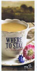
Leaflet, Nillumbik Tourist Association, Where to stay in Nillumbik, 17/10/2015
... Greensborough Historical Society 34A Glenauburn Road Lower Plenty Lower Plenty melbourne Lists 10 major tourist accommodations in: Bundoora, Diamond Creek, Eltham, Hurstbridge, Kangaroo Ground, Panton Hill, Research, St Andrews nillumbik Colour, printed both sides, map of area, A4 folded twice Where to stay in Nillumbik Leaflet Nillumbik Tourist Association ...Lists 10 major tourist accommodations in: Bundoora, Diamond Creek, Eltham, Hurstbridge, Kangaroo Ground, Panton Hill, Research, St AndrewsColour, printed both sides, map of area, A4 folded twicenillumbik -
 Greensborough Historical Society
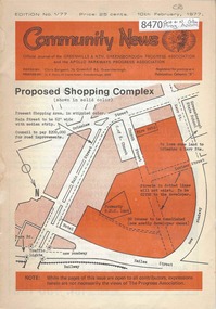
Newsletter, Greenhills and North Greensborough Progress Association, Community News: official journal of the Greenhills and Nth. Greensborough Progress Association and the Apollo Parkways Progress Association.10th February, 1977. Edition No. 1/77, 10/02/1977
... Diamond Creek, This and that,. Supplement to "Community News". No. 1/77. Geoff Kerry has a... Community News "family chat". A digital copy of this Newsletter is available from Greensborough Historical Society. Greenhills and North Greensborough Progress Association greenhills Apollo Parkways Progress Association apollo parkways Newsletter, 20 p., illus., map. ...Proposed shopping complex - Public meeting, Super shops, Letters to the Editor, From the Council Chamber, Freedom from despair, Grow, Co-operative education in Diamond Creek, This and that,. Supplement to "Community News". No. 1/77. Geoff Kerry has a... Community News "family chat". A digital copy of this Newsletter is available from Greensborough Historical Society. Newsletter, 20 p., illus., map.greenhills and north greensborough progress association, greenhills, apollo parkways progress association, apollo parkways -
 Greensborough Historical Society
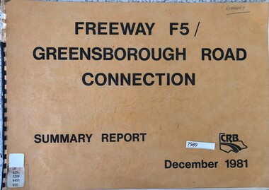
Book - Report, Country Roads Board, Freeway F5 / Greensborough Road connection. December 1981, Summary Report, 1981_
... Diamond Creek Road and the duplication of Greensborough Road (Greensborough By-pass). Historic proposal for roads in the Greensborough area country roads board greensborough bypass metropolitan ring road greensborough road 51 pages, text, colour maps. ...Summary report of the Country Roads Board's 1981 proposals for the F5 Freeway (now Metropolitan Ring Road) between Dalton Road and Diamond Creek Road and the duplication of Greensborough Road (Greensborough By-pass).Historic proposal for roads in the Greensborough area51 pages, text, colour maps. Plastic binding.country roads board, greensborough bypass, metropolitan ring road, greensborough road -
 Greensborough Historical Society
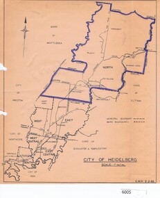
Map, City of Heidelberg, City of Heidelberg, 1962, 02/02/1962
... Map of City of Heidelberg showing boundaries of its six wards; North Ward is highlighted, covering Watsonia, Greensborough, part Bundoora, St Helena, Plenty, Yarrambat and Diamond Creek....Greensborough Historical Society 34A Glenauburn Road Lower Plenty Lower Plenty melbourne Map of City of Heidelberg showing boundaries of its six wards; North Ward is highlighted, covering Watsonia, Greensborough, part Bundoora, St Helena, Plenty, Yarrambat and Diamond Creek. city of heidelberg heidelberg - maps City of Heidelberg Scale: 1" to 1 ml. ...Map of City of Heidelberg showing boundaries of its six wards; North Ward is highlighted, covering Watsonia, Greensborough, part Bundoora, St Helena, Plenty, Yarrambat and Diamond Creek.Blue print mapCity of Heidelberg Scale: 1" to 1 ml. G.M.H. 2.2.62city of heidelberg, heidelberg - maps -
 Greensborough Historical Society
Map, Heidelberg: Historic River Landscape Assessment. Historical Maps. Map B 1838-1851, "The Distinctly aristocratic locality", 1985c
... Bounded by Shire of Diamond Valley to the North, Darebin Creek to the West and Plenty River to the East heidelberg heidelberg - maps Black and white sketch map on white paper Heidelberg: Historic River Landscape Assessment. ...Geographical area of around 35 sq. kilometres marked with physical features such as major roads, rivers, vegetation and properties, with contemporary notes on landowners, descriptions and comments on the land and its development. Bounded by Shire of Diamond Valley to the North, Darebin Creek to the West and Plenty River to the EastBlack and white sketch map on white paperheidelberg, heidelberg - maps -
 Greensborough Historical Society
Map, Heidelberg. Historic River Landscape Assessment. Historical maps: Map C 1851-1863. "The Garden of the colony", 1985c
... Bounded by Shire of Diamond Valley to the North, Darebin Creek to the West and Plenty River to the East. heidelberg heidelberg - maps Black and white sketch map on white paper Heidelberg. ...Geographical area of around 35 sq. kilometres marked with physical features such as major roads, vegetation and properties, with locations and notes of the increasing number of farms, gardens orchards and vineyards which had become established in addition to pastoral runs. Bounded by Shire of Diamond Valley to the North, Darebin Creek to the West and Plenty River to the East.Black and white sketch map on white paperheidelberg, heidelberg - maps -
 Greensborough Historical Society
Map, Heidelberg: Historic River Landscape Assessment. Historical maps. Map D 1864 -1901 "Sleepy Hollow" and "Sleeping beauty", 1985c
... Bounded by Shire of Diamond Valley to the North, Darebin Creek to the West, and Plenty River to the East. heidelberg heidelberg - maps Black and white sketch on white paper. ...Geographical area of c. 35 sq. kilometres marked with physical features such as major roads, rivers, vegetation and properties, with locations and notes on the increasing number of farms, orchards and vineyards that had been developed in addition to pastoral runs. Bounded by Shire of Diamond Valley to the North, Darebin Creek to the West, and Plenty River to the East.Black and white sketch on white paper. Second copy 600 x 430 cm printed in black on semi-opaque paperheidelberg, heidelberg - maps -
 Greensborough Historical Society
Map, Heidelberg: Historic River Landscape Assessment. Historical maps. Map E 1901-1934 "A Time of projects and improvements", 1985c
... Bounded by Shire of Diamond Valley to the North, Darebin Creek to the West and Plenty River to the East. heidelberg heidelberg - maps Black and white sketch map on white paper Heidelberg: Historic River Landscape Assessment. ...Geographical area of around 35 sq. kilometres marked with physical features such as major roads, railways (new extension to Eltham), rivers and properties, also housing sub-divisions and community facilities such as hospitals, parks and sporting reserves and indications of new small scale industries such as dairying. Bounded by Shire of Diamond Valley to the North, Darebin Creek to the West and Plenty River to the East. Black and white sketch map on white paperheidelberg, heidelberg - maps -
 Eltham District Historical Society Inc
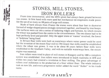
Folder, Eltham Flour Mill
... Also includes pages from an unknown source describing the operation of the mill and map with location of mill marked. The Eltham Flour Mill was situated on the Diamond Creek below the location of the Eltham Community and Reception Centre....Also includes pages from an unknown source describing the operation of the mill and map with location of mill marked. The Eltham Flour Mill was situated on the Diamond Creek below the location of the Eltham Community and Reception Centre. harry gilham collection eltham flour mill henry dendy william ford HG Folders 113 8 Pages Eltham Flour Mill Folder ...Photocopied pages probably from "Flour mills and millers of the Goulburn Valley, 1858-1980" by Myrtle L. Ford (1981) relating to Eltham Flour Mill Proprietor William Ford and his predecessor Henry Dendy and the operation of the Eltham Flour Mill. Also includes pages from an unknown source describing the operation of the mill and map with location of mill marked. The Eltham Flour Mill was situated on the Diamond Creek below the location of the Eltham Community and Reception Centre.8 PagesHG Folders 113harry gilham collection, eltham flour mill, henry dendy, william ford -
 Eltham District Historical Society Inc
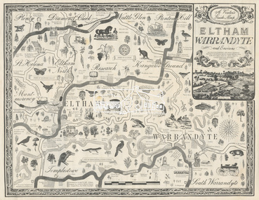
Map, George W. Bell, A Visitor's Guide Map; ELTHAM, WARRANDYTE and Environs, c.1969
... map...country art store...diamond creek...Diamond Creek Handicrafts, Diamond Creek Eltham Crafts, Eltham John Mills, Eltham Potters Cottage, Warrandyte Setel Downs, Kangaroo Ground The Claypot, Warrandyte Warrandyte Quarries and Pottery, Warrandyte GOOD FOOD AND DRINK Alfred's Homestead, Warrandyte Geranium Parlour,. Research Inglenook, Warrandyte La Ronde, Eltham The Barrel, Research The Potters Restaurant, Warrandyte Setel Downs, Kangaroo Ground GALLERIES Hassall's Gallery, Research Lodge Gallery, Warrandyte The Bird Gallery, Eltham Royalat Gallery, Panton Hill PLANTYS, TREES AND SHRUBS Danson's Gardens, Research Dean's Orchids & Dahlias, Templestowe Diamond Vlley Trees & Shrubs, Warrandyte Jum Jum, Diamond Creek Parson's, Research Tantoon, Eltham Warran Glen, Warrandyte eltham warrandyte map country art store diamond creek handicrafts eltham crafts john mills potters cottage setel downs the claypot warrandyte quarries and pottery alfred's homestead geranium parlour inglenook la ronde the barrel the potters restaurant hassall's gallery lodge gallery the bird gallery royalat gallery danson's gardens dean's orchids & dahlias diamond vlley trees & shrubs jum jum parson's tantoon warran glen advertising eltham barrel 44..8 x 57.5 cm (Two copies) On the reverse side (of one copy only) is printed in 8 panels (3 half-folds) advertising A Visitor's Guide Map; ELTHAM, WARRANDYTE and Environs Map Map George W. ...Commissioned by George W. Bell, designed by Anthony Harvey. An old gold mining and wine growing district eighteen miles from Melbourne, now notable for its arts, crafts, good food and historic buildings. On the reverse side (of one copy only) is printed in 8 panels (3 half-folds) advertising for Montsalvat, Eltham; Setel Downs Coffee Kitchen Art Gallery, Kangaroo Ground; Country Art Store, Eltham; Alfred's Homestead, Warrandyte; Neville F Emmerson Estate Agent, Lower Plenty; Eltham Crafts. Monstsalvat, Eltham; Tantoon native plants and culinary herbs, Eltham; Flavour of Eltham, Shillinglaw Coattage Preservation Society; The Eltham Barrel; Potters Cottage, Warrandyte. In addition is provided by cateogory listing: POTTERY AND CRAFTS Country Art Store, Eltham Diamond Creek Handicrafts, Diamond Creek Eltham Crafts, Eltham John Mills, Eltham Potters Cottage, Warrandyte Setel Downs, Kangaroo Ground The Claypot, Warrandyte Warrandyte Quarries and Pottery, Warrandyte GOOD FOOD AND DRINK Alfred's Homestead, Warrandyte Geranium Parlour,. Research Inglenook, Warrandyte La Ronde, Eltham The Barrel, Research The Potters Restaurant, Warrandyte Setel Downs, Kangaroo Ground GALLERIES Hassall's Gallery, Research Lodge Gallery, Warrandyte The Bird Gallery, Eltham Royalat Gallery, Panton Hill PLANTYS, TREES AND SHRUBS Danson's Gardens, Research Dean's Orchids & Dahlias, Templestowe Diamond Vlley Trees & Shrubs, Warrandyte Jum Jum, Diamond Creek Parson's, Research Tantoon, Eltham Warran Glen, Warrandyte44..8 x 57.5 cm (Two copies) On the reverse side (of one copy only) is printed in 8 panels (3 half-folds) advertisingeltham, warrandyte, map, country art store, diamond creek handicrafts, eltham crafts, john mills, potters cottage, setel downs, the claypot, warrandyte quarries and pottery, alfred's homestead, geranium parlour, inglenook, la ronde, the barrel, the potters restaurant, hassall's gallery, lodge gallery, the bird gallery, royalat gallery, danson's gardens, dean's orchids & dahlias, diamond vlley trees & shrubs, jum jum, parson's, tantoon, warran glen, advertising, eltham barrel -
 Eltham District Historical Society Inc
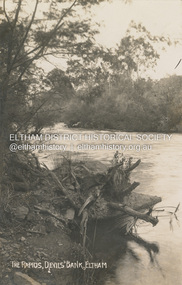
Postcard - Photograph postcard, The Rapids, Devils' Bank, Eltham, 1907
... Diamond Creek. Only three properties existed in this area in 1945 aerial maps, Worlingworth and the adjoining property on the bank of the Diamond Creek in Banoon Road and No. 2 Kent Hughes Road. ...Diamond Creek. Only three properties existed in this area in 1945 aerial maps, Worlingworth and the adjoining property on the bank of the Diamond Creek in Banoon Road and No. 2 Kent Hughes Road. ...Devils' Bank was situated some two miles from Eltham. It is probably the section along the Yarra River where there are a series of rapids stretching past Petty's Orchard to Griffiths Park and the confluence with the Diamond Creek. Only three properties existed in this area in 1945 aerial maps, Worlingworth and the adjoining property on the bank of the Diamond Creek in Banoon Road and No. 2 Kent Hughes Road. Devils' Bank. The death of Ann Edwards, 77 years, an old resident of the district was reported who lived in an old hut at Devil's Bank who had been found dead in her bed on 13 May 1897 FOUND DEAD IN BED. (1897, May 28). Evelyn Observer, and South and East Bourke Record (Vic. : 1882 - 1902), p. 2 (MORNING.). Retrieved September 3, 2022, from http://nla.gov.au/nla.news-article60696388 A very similar view was published in the Leader paper in January 1908 - Devil's Bank Falls, Eltham VIEWS ON THE UPPER YARRA. (1908, January 11). Leader (Melbourne, Vic. : 1862 - 1918, 1935), p. 28. Retrieved September 3, 2022, from http://nla.gov.au/nla.news-article198106006 On the reverse of the postcard it appears to be postmarked Eltham, Dec 27, 1907 addressed to Mrs Christie Millmoss of Bull Street, Bendigo "Arrived here 10.45 am - ? ? raining cause of ? - ? till evenings it is lovely - but quite fresh after the (rain - crossed out) great ? - I may assume it all go well"Digital file only Postcards scanned from the collection of Michael Aitken on loan to EDHS, 2 Sep. 2022michael aitken collection, devils bank, eltham, postcards, rapids, yarra river -
 Eltham District Historical Society Inc
Photograph - Colour Print, Belle Vue, Livingstone Road, Eltham, c.2015
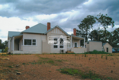
... On the present day map the southern boundary was just north of Elsa Court and Grove Street. The western boundary was the Diamond Creek and extended northerly to Main Road where it turns easterly towards Research. ...On the present day map the southern boundary was just north of Elsa Court and Grove Street. The western boundary was the Diamond Creek and extended northerly to Main Road where it turns easterly towards Research. ...Belle Vue property in Livingstone Road, Eltham was once owned by Society member Jo McCormick. Jo was a valued member of our committee and dear friend of many of our members until her death in 2009. Belle Vue is the farmhouse of a property that is now a significant part of suburban Eltham, just a short distance north of the town centre. Originally purchased by pioneer Eltham farmer Henry Stooke, the present-day old farmhouse sits within an extensive suburban residential area. The history of the property is largely based on a heritage assessment prepared by consultant Lorraine Huddle for Nillumbik Shire Council. Additional information from our Society records reveals Belle Vue farm comprised about 56 ha (140 acres) extending northerly from the northern boundary of Holloway’s 1851 Little Eltham subdivision. On the present day map the southern boundary was just north of Elsa Court and Grove Street. The western boundary was the Diamond Creek and extended northerly to Main Road where it turns easterly towards Research. It was traversed by the main road to Kangaroo Ground and beyond and from 1912 by the railway to Hurstbridge. From 1895 the farm was owned by William Williams and his wife Mary Ann. In 1914 -15 they built a new house now known as Belle Vue. They sold the land in 1920 and residential subdivision began soon after that. Belle Vue remains today on a substantially subdivided and very much reduced size residential lot in Livingstone Road. The house and many old trees on the site were subject to a heritage overlay under the Nillumbik Planning Scheme. Despite that overlay, the development and subdivision of the original land resulted in most of the heritage listed trees being removed. belle vue, eltham, livingstone road -
 Eltham District Historical Society Inc
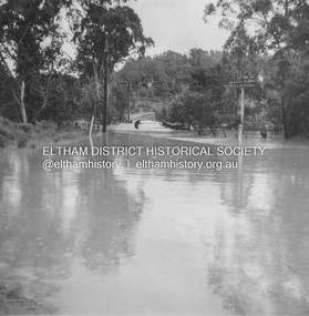
Album - Photograph, J.A. McDonald, Eltham-Diamond Creek Road, 21 Oct. 1953
... Diamond Creek road which ran past the entrance of the present-day carpark for Edendale Farm. This view is looking west across the Glen Park Bridge, and the beginning of Wattletree Road which sweeps around to the right in the distance. Progress Road does not exist though a road reserve is present on maps...Diamond Creek road which ran past the entrance of the present-day carpark for Edendale Farm. This view is looking west across the Glen Park Bridge, and the beginning of Wattletree Road which sweeps around to the right in the distance. Progress Road does not exist though a road reserve is present on maps ...18 October 1956 Flood level on road at corner of Railway Parade. On the immediate left out of view is Mrs Lucy Egan's home. That house still stands today nestled up against the Wattletree Road Bridge on the other side built in 1959 and is owned by the Bakos family purchased by Mrs Heather Bakos in 1960.. Prior to the Wattletree Road bridge being built, Railway Parade extended up the alignment of present-day Gastons Road to the Eltham-Diamond Creek road which ran past the entrance of the present-day carpark for Edendale Farm. This view is looking west across the Glen Park Bridge, and the beginning of Wattletree Road which sweeps around to the right in the distance. Progress Road does not exist though a road reserve is present on maps.Record of various Shire of Eltham infrastructure works undertaken during the period of 1952-1962 involving bridge and road reconstruction projects, sometimes with Eltham Shire Council Project Reference numbers quoted. It was during this period that a number of significant improvements were made to roads and new bridges constructed within the shire that remain in place as of present day (2022). In many situations, the photos provide a tangible visible record of infrastructure that existed throughout the early days of the Shire. The album was put together by or under the direction of the Shire Engineer, J.A. McDonald.infrastructure, road construction, shire of eltham, bridge construction, eltham north, floods, floodwater, glen park bridge, 1956-10-18, diamond creek (creek), eltham, railway parade, wattletree road, wattletree road bridge, gastons road -
 Eltham District Historical Society Inc
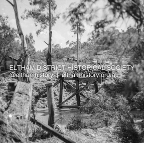
Negative - Photograph, J.A. McDonald, Eltham-Diamond Creek Road, 21 Sep 1959
... Diamond Creek side abutment for the new Wattletree Road bridge under construction. Where the trucks are parked is near the present-day intersection with Progress Road. At the time Progress Road did not exist and was merely a road reserve on the map...Diamond Creek side abutment for the new Wattletree Road bridge under construction. Where the trucks are parked is near the present-day intersection with Progress Road. At the time Progress Road did not exist and was merely a road reserve on the map ...Bridge construction Eltham-Diamond Creek road over the Diamond Creek (Wattletree Road), Eltham, September 1959 After some delay in receiving funds, work started on the bridge approaches in early September 1959. Traffic was still using the old bridge upstream. On Sunday, 20 September 1959, heavy flooding occurred in the stream and at 3:53 pm the old bridge was washed out. This photo was taken the day after. To the left is the Diamond Creek side abutment for the new Wattletree Road bridge under construction. Where the trucks are parked is near the present-day intersection with Progress Road. At the time Progress Road did not exist and was merely a road reserve on the map. The bridge was originally built as a replacement for an older private bridge built by a man named Foley around 1880. In 1911 Heidelberg and Eltham agreed to share the costs to build a new bridge. Construction began in June 1915 and it was officially opened by Cr. Taylor on Cup Day, November 1915.Record of various Shire of Eltham infrastructure works undertaken during the period of 1952-1962 involving bridge and road reconstruction projects, sometimes with Eltham Shire Council Project Reference numbers quoted. It was during this period that a number of significant improvements were made to roads and new bridges constructed within the shire that remain in place as of present day (2022). In many situations, the photos provide a tangible visible record of infrastructure that existed throughout the early days of the Shire. The album was put together by or under the direction of the Shire Engineer, J.A. McDonald.infrastructure, shire of eltham, bridge construction, bridge, diamond creek (creek), eltham, eltham north, glen park bridge, 1959-09-21, flood damage, wattletree road bridge