Showing 36 items matching "east end shops"
-
 Whitehorse Historical Society Inc.
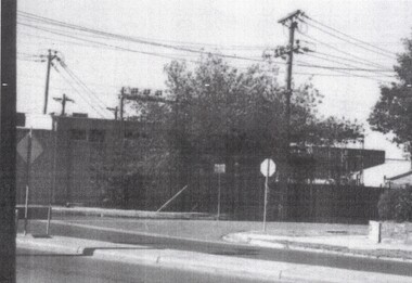
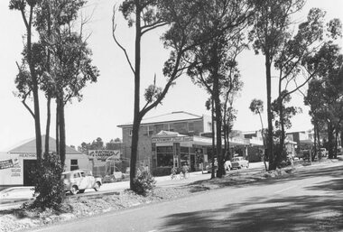
Photograph - Strip photo and photocopy, Railway Road Blackburn, 1/08/1976 12:00:00 AM
... ...East end shops...Whitehorse Historical Society Inc. 2-10 Deep Creek Road Mitcham melbourne Railway Road Blackburn Blackburn East end shops Railway Road, Blackburn. East end in August 1976. ...Railway Road, Blackburn. East end in August 1976.railway road blackburn, blackburn, east end shops -
 Charlton Golden Grains Museum Inc
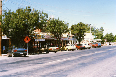
Photograph, Charlton Shire, Shops, east end of High St, Charlton c. 1987, c.1987
... Shops, east end of High St, Charlton c. 1987...shop verandahs. From left to right; The Sun, THE AGE, Bendigo Advertiser , FUN PARLOR, (both partially obscured by a tree), FRUIT & VEGETABLES, 7 DAYS WEEKLY, FISH & CHIPS, CHICKENS B.B.Q. Building at the end of the shops is a Butchery and has a large sign for FEEDLOT STEAKS on the side wall. Shops, east ...Newsagency established c. 1912 by Dudley & Morse. Sold to F Jones in early 1940's. Royal Cafe built for Travaglia's c. 1912Colour photograph showing a row of shops. Cars are parked in front of the shops and there are three trees. An orange school crossing sign is next to dark blue car. Person in pale blue on LH side of photo. There are a variety of signs displayed along the front of the shop verandahs. From left to right; The Sun, THE AGE, Bendigo Advertiser , FUN PARLOR, (both partially obscured by a tree), FRUIT & VEGETABLES, 7 DAYS WEEKLY, FISH & CHIPS, CHICKENS B.B.Q. Building at the end of the shops is a Butchery and has a large sign for FEEDLOT STEAKS on the side wall.dudley, morse, f jones, royal cafe, travaglia, charlton, business -
 Buninyong & District Historical Society
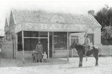
Photograph - B/W photograph, Samuel Bailey's Butcher Shop, Main Rd. Ballarat East, c 1879, 1994
... B/W photo, Samuel Bailey's East End Butchery Shop, Main Rd. Ballarat East, c 1879...shop, Main Rd. Ballarat East, circa 18798, opposite Sovereign Hill (Opposite Nettleton's, which was at the base of Sovereign Hill) B/W photo, Samuel Bailey's East End Butchery Shop, Main Rd. ...Lost buildingB/W photo, Samuel Bailey's East End Butchery Shop, Main Rd. Ballarat East, c 1879"Samuel Bailey's Butcher shop, Main Rd. Ballarat East, circa 18798, opposite Sovereign Hill (Opposite Nettleton's, which was at the base of Sovereign Hill) shop, butcher, samuel bailey -
 Port of Echuca
Colour photograph, Approx. 1979
... east corner of Hare and Anstruther streets. In the front of the building is a small cream brick kiosk used as a bus stop and as a stall for charity group's to sell produce. On the far northern corner the spire of St.Mary's church can be seen above the roof of the Post Office. The old Echuca Post office is at the northern end of the shopping ...The old Echuca Post Office was built circa 1877, a two-storey stucco building with a clock tower over the entrance, on the north east corner of Hare and Anstruther streets. In the front of the building is a small cream brick kiosk used as a bus stop and as a stall for charity group's to sell produce. On the far northern corner the spire of St.Mary's church can be seen above the roof of the Post Office.The old Echuca Post office is at the northern end of the shopping precinct in Hare street Echuca. The building is a beautiful grand building of the late 1870's which was built as a post office on the ground floor and a residence above. The small kiosk building in front of the post office was used by volunteer organisations to raise money selling cakes etc. at various times of the year.Colour photograph (post card size) of Echuca Post Office looking north. The post office was built circa 1877, a two storey building with a clock tower over the entrance door. In front of the building is a small cream brick kiosk and bus shelter.Printed on the reverse "this paper manufactured by Kodak"echuca post office, echuca-historical buildings -
 Eltham District Historical Society Inc
Photograph, Research Shops precinct
... Shops: 1. At Main Road and Warrandyte Road roundabout looking south east towards the shops 2. At the north end of the shops at intersection of Raglan Road and Main Road looking north east...Shops: 1. At Main Road and Warrandyte Road roundabout looking south east towards the shops 2. At the north end of the shops at intersection of Raglan Road and Main Road looking north east Research Shops precinct Photograph ...Two colour photographs in the vicinity of Research Shops: 1. At Main Road and Warrandyte Road roundabout looking south east towards the shops 2. At the north end of the shops at intersection of Raglan Road and Main Road looking north eastmain road, research, ingrams road, shops, roundabouts -
 Montmorency–Eltham RSL Sub Branch
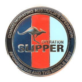
Medal - Commemorative Medallion
... Australia's military contribution to the International Security Assistance Force mission in Afghanistan ended in 2014, making Operation Slipper Australia's longest running operation. commemoration operation slipper afghanistan australian army middle east international security assistance force On front of medallion, "Operation Slipper", "Commemorating Australia's Operation/Afghanistan and the Middle East" On reverse, "Operation Slipper" and "2001 - 2014" and the Australian Coat of Arms. This commemorative medallion features the tri-service colours, navy, red and light blue, representing the Australian Defence Force, and a golden bounding kangaroo to represent non-combatant contributions. Commemorative text encircles the kangaroo motif and Coat of Arms on the front and back, respectively. Medal Commemorative Medallion Military Shop ...In November 2001 Australian SAS troops joined the war in Afghanistan under the operation name "Operation Slipper." Australia's military contribution to the International Security Assistance Force mission in Afghanistan ended in 2014, making Operation Slipper Australia's longest running operation.This commemorative medallion features the tri-service colours, navy, red and light blue, representing the Australian Defence Force, and a golden bounding kangaroo to represent non-combatant contributions. Commemorative text encircles the kangaroo motif and Coat of Arms on the front and back, respectively.On front of medallion, "Operation Slipper", "Commemorating Australia's Operation/Afghanistan and the Middle East" On reverse, "Operation Slipper" and "2001 - 2014" and the Australian Coat of Arms.commemoration, operation slipper, afghanistan, australian army, middle east, international security assistance force -
 Charlton Golden Grains Museum Inc
Photograph, Brownjohn, Reg, War Memorial High St Charlton c. 1990, c. 1990
... shops at the west end of High St Charlton. Shops include Paterson's Welcome Mart, Eddie Harris Mensland, Charlton Cinema, panel beaters, Tippett's Haberdashery & Furnishings paterson's welcome mart charlton cinema Charlton High Street War Memorial Colour photo of War Memorial looking east down High St. ...War Memorial and shops at the west end of High St Charlton. Shops include Paterson's Welcome Mart, Eddie Harris Mensland, Charlton Cinema, panel beaters, Tippett's Haberdashery & FurnishingsColour photo of War Memorial looking east down High St. Back view of memorial. No entry sign.paterson's welcome mart, charlton cinema, charlton, high street, war memorial -
 Charlton Golden Grains Museum Inc
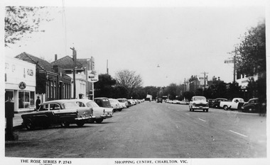
Photograph - Postcard, Jone's Newsagency, Shopping Centre, Charlton. Vic, c.1950
... East Charlton Hotel, Globe Hotel,. Fire station at far end of High Street. Kitchin Garage Kerrs Garage ANZ Bank State Bank East Charlton Hotel Globe Hotel High Street Rose Series Charlton Business Shopping Centre, Charlton. ...Postcard part of a set of photos of Charlton buildings c. 1950 produced for sale at Jones Newsagency.. Businesses on the LH side - Kitchin/Kerrs Garage, Post Office, ANZ Bank, State Bank. On the RH side - East Charlton Hotel, Globe Hotel,. Fire station at far end of High Street.Postcard showing High St Charlton looking west. Cars parked on both sides of the street and several cars driving toward photographer. Woman walking past Holden dealership. Mobil Service sign. Businesses on the LH side - Kitchin/Kerrs Garage, Post Office, ANZ bank, State Bank. On the RH side - East Charlton Hotel, Globe Hotel,. Fire station at far end of High Street.Shopping Centre, Charlton. Vic. The Rose Series P. 2743kitchin garage, kerrs garage, anz bank, state bank, east charlton hotel, globe hotel, high street, rose series, charlton, business -
 Charlton Golden Grains Museum Inc
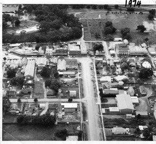
Photograph, Aerial photo of Armstrong St, Charlton, c.1974
... On High St (from L-R) Dr Surgery, H Bath Chemist, Grocery, Roy Dobson, Hairdresser, Stowe's, Westpac Bank (two storey white building), Dillon's Building, Globe Hotel, Charlton Club, butcher shop, Arundell's shoe shop, Watson's Stock & Station Agency, Bullock's grocery, Williams St (Curtin Ave), Bannon's Butchers, East Charlton Hotel, MB Luth & Co, Lou's cafe. The old sale yards are at the end...On High St (from L-R) Dr Surgery, H Bath Chemist, Grocery, Roy Dobson, Hairdresser, Stowe's, Westpac Bank (two storey white building), Dillon's Building, Globe Hotel, Charlton Club, butcher shop, Arundell's shoe shop, Watson's Stock & Station Agency, Bullock's grocery, Williams St (Curtin Ave), Bannon's Butchers, East Charlton Hotel, MB Luth & Co, Lou's cafe. The old sale yards are at the end ...Aerial photo looking down Armstrong St. Camp street on the left, Shire Hall on the right. High St runs across the photo. The Avoca River is visible in the top LH side. The swimming pool and bowling green is above the rive. On High St (from L-R) Dr Surgery, H Bath Chemist, Grocery, Roy Dobson, Hairdresser, Stowe's, Westpac Bank (two storey white building), Dillon's Building, Globe Hotel, Charlton Club, butcher shop, Arundell's shoe shop, Watson's Stock & Station Agency, Bullock's grocery, Williams St (Curtin Ave), Bannon's Butchers, East Charlton Hotel, MB Luth & Co, Lou's cafe. The old sale yards are at the end of Williams Street. Camp St lower side (from L-R) Court House, Police residence, Police Station, Telecom on corner. The photo is thought to be taken from Ossie Sanderson's airplane in 1974.Black & white aerial photo looking down a broad street that ends in a t-intersection. There is a street that comes off to the left about 1/3 of the way up the photo. There is a large building directly opposite this street. In the upper right there is a two storey building with arches on its verandah. In the upper LH side there is a swimming pool and bowling greens.armstrong st charlton, charlton, business, industry, westpac bank, globe hotel, east charlton hotel, dillon building -
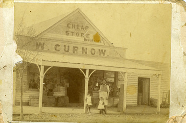 Charlton Golden Grains Museum Inc
Photograph, c.1893
... General store east end of High Street.W. Curnow store High Street Charlton established 1877. Shops Business Charlton Curnow Sepia photo of W. ...Photo of W. Curnow store on 99 High Street Charlton. c.1893. W. Curnow stands in front of the store with two young daughters. General store east end of High Street.W. Curnow store High Street Charlton established 1877.Sepia photo of W. Curnow standing in front of store with two young daughters. Sign on store reads 'Cheap Store. W. Curnow'. W. Curnow store High Street Charlton 1877.shops, business, charlton, curnow -
 Ringwood and District Historical Society
Photographs, Ringwood shops along Maroondah Hwy from Ringwood St to Warrandyte Road in 1997
... 491_001 - east of Melbourne St 491_002 - Melbourne St, showing old library at end 491_003 - shops 491_004 - old State Bank...Ringwood and District Historical Society 125A Warrandyte Road Ringwood North melbourne 491_001 - east of Melbourne St 491_002 - Melbourne St, showing old library at end 491_003 - shops 491_004 - old State Bank Ringwood shops along Maroondah Hwy from Ringwood St to Warrandyte Road in 1997 Photographs ...491_001 - east of Melbourne St 491_002 - Melbourne St, showing old library at end 491_003 - shops 491_004 - old State Bank -
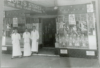 City of Moorabbin Historical Society (Operating the Box Cottage Museum)
Photograph - Black & White, Crofts Grocery 395 Centre Rd Bentleigh c1937, c1937
... After the extension of the Railway line from Caulfield to Mordialloc 1880's the shopping centre moved from the Tucker Rd end to around the East Brighton (Bentleigh) Station area of Centre Road. ...City of Moorabbin Historical Society (Operating the Box Cottage Museum) Joyce Park Jasper Road Ormond melbourne After the extension of the Railway line from Caulfield to Mordialloc 1880's the shopping centre moved from the Tucker Rd end to around the East Brighton (Bentleigh) Station area of Centre Road. ...After the extension of the Railway line from Caulfield to Mordialloc 1880's the shopping centre moved from the Tucker Rd end to around the East Brighton (Bentleigh) Station area of Centre Road. A variety of shops, forges, estate agents, Coles' and Fossey's variety stores, a Hoyts picture theatre, butchers, traded in Centre Rd. Crofts was one many grocery stores along the strip. Crofts Stores was established by Archibald Crofts (1875-1942) as a single grocery store in South Melbourne. It eventually expanded to include 137 branches throughout Victoria, trading as Crofts Stores. The Lees family had established a Seedling Nursery in Thomas St that has continued until the land sold 2018 for housing development.Crofts Grocery Store was one of the shops in the Centre Road Bentleigh shopping strip that were established after the arrival of the train line 1881Black & White photograph of 3 men outside Crofts Grocery Store 395 Centre Rd Bentleigh c 1937 Mr Jack Lees is centre.Handwritten informationcrofts grocery store bentleigh, lees jack, mordialloc railway line, centre road bentleigh, smith j l, smith mary ann, stanley helen, smith vic, smith harry redvers, chaff cutter, horse drawn carts, toll gates brighton, motor cars 1900, steam engines, early settlers, bentleigh, parish of moorabbin, city of moorabbin, county of bourke, moorabbin roads board, shire of moorabbin, henry dendy's special survey 1841, were j.b., bent thomas, o'shannassy john, king richard, charman stephen, highett william, ormond francis, maynard dennis, market gardeners, vineyards -
 Ringwood and District Historical Society
Photograph-B&W, Joan Walker, East Ringwood 2000-Shops in Railway Avenue (Dublin Road end), 2000
... East Ringwood 2000-Shops in Railway Avenue (Dublin Road end)- B&W Photo from Album 6501...Ringwood and District Historical Society 125A Warrandyte Road Ringwood North melbourne East Ringwood 2000-Shops in Railway Avenue (Dublin Road end)- B&W Photo from Album 6501 East Ringwood 2000-Shops in Railway Avenue (Dublin Road end) Photograph-B&W Joan Walker ...East Ringwood 2000-Shops in Railway Avenue (Dublin Road end)- B&W Photo from Album 6501 -
 Ringwood and District Historical Society
Photograph, Heathmont shopping centre - East end, Feb. 1960
... Typed below photograph, "Heathmont shopping centre - East end, Feb. 1960"....Ringwood and District Historical Society 125A Warrandyte Road Ringwood North melbourne Typed below photograph, "Heathmont shopping centre - East end, Feb. 1960". Heathmont shopping centre - East end, Feb. 1960 Photograph ...Typed below photograph, "Heathmont shopping centre - East end, Feb. 1960". -
 Ringwood and District Historical Society
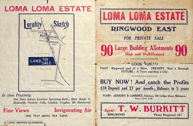
Flyer, Land Sale Brochure, Loma Loma Estate, Ringwood East, Vic. - circa 1924
... shops and 720 people. In 1918 the respective figures were 520, 45 and 2,080. For twelve months ended June, 1924, £51,000 worth of Home Sites were sold and £26,000 worth of new buildings were erected. Outward (train) passenger journeys have increased from 94,000 in 1919 to 182,000 in 1923. Train services have been almost doubled and time to Melbourne reduced from 60 to 37 minutes." Subdivision includes Loma Street, Highton Street, Morinda Street, and Station Street (later Railway Avenue) Ringwood East ...Flyer includes extract from "The Sun" 30/10/1924. "Ringwood has been created a Borough with capital value of £680,000. In 1908 there were 173 houses, 8 shops and 720 people. In 1918 the respective figures were 520, 45 and 2,080. For twelve months ended June, 1924, £51,000 worth of Home Sites were sold and £26,000 worth of new buildings were erected. Outward (train) passenger journeys have increased from 94,000 in 1919 to 182,000 in 1923. Train services have been almost doubled and time to Melbourne reduced from 60 to 37 minutes."Bi-fold double-sided land sale advertisement for Loma Loma Estate, Ringwood East, including area map, layout of the estate, and summary of local facilities and services.Subdivision includes Loma Street, Highton Street, Morinda Street, and Station Street (later Railway Avenue) Ringwood East. Agent: T.W. Burkitt, Ringwood, Phone Ringwood 157. -
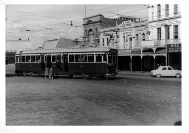
 Ballarat Tramway Museum
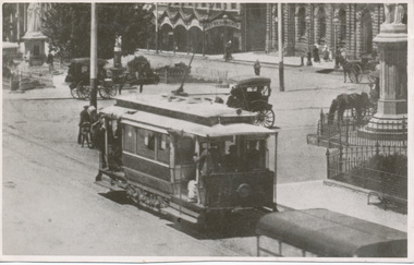
Photograph - Digital image of ESCo tram 5 in Sturt St c1910
... Digital image from the Wal Jack Ballarat Album of ESCo No. 5 in Sturt St, east bound at Armstrong St. with the Town Hall, National Mutual building and other shops in the background. Has a number of horse drawn vehicles, and people on both the rear and front end of the tram....Ballarat Tramway Museum South Gardens Reserve Wendouree Parade Ballarat Ballarat goldfields Digital image from the Wal Jack Ballarat Album of ESCo No. 5 in Sturt St, east bound at Armstrong St. with the Town Hall, National Mutual building and other shops in the background. Has a number of horse drawn vehicles, and people on both the rear and front end of the tram. ...Digital image from the Wal Jack Ballarat Album of ESCo No. 5 in Sturt St, east bound at Armstrong St. with the Town Hall, National Mutual building and other shops in the background. Has a number of horse drawn vehicles, and people on both the rear and front end of the tram.Yields information about Sturt St and ESCo trams.Digital image of a photograph that was made from a postcard.On rear in ink "B'rat ? No. 5 in Sturt St" and in bottom right hand corner, CRC Field of Sydney photograph stamp, "2203 ?" and "per C. Fere"trams, tramways, sturt st, esco, tram 5, town hall -
 Ballarat Tramway Museum
Photograph - Digital image, Wal Jack, 12/08/1961 12:00:00 AM
... In the background are the shops at the south east end of Sturt St, including Gear Chemist, Rowes for Cakes, Lascotte Tea Rooms, Union Hotel and Bill? ...east end. Trams tramways Sturt St Grenville St tram 37 On rear of photograph in ink "SEC, Ballarat 2nd No. 37 ex Bendigo No. 1 bogies, Sturt St 12-8-61" and Wal Jack stamp in top right hand corner with number "T1262" written in. Digital image from the Wal Jack Ballarat Album of a photograph of No. 37 in Sturt St, after crossing Grenville St. Has two young children alongside the tram. In the background are the shops ...Yields information about the tram operation in 1961 and the appearance of the Sturt St east end.Digital image from the Wal Jack Ballarat Album of a photograph of No. 37 in Sturt St, after crossing Grenville St. Has two young children alongside the tram. In the background are the shops at the south east end of Sturt St, including Gear Chemist, Rowes for Cakes, Lascotte Tea Rooms, Union Hotel and Bill? High Class Milk Bar. Photo Wal Jack 12-8-1961. See image i2 for rear of photograph. See image i3 for hi res scan of print. See image i4 for hi res scan of negativeOn rear of photograph in ink "SEC, Ballarat 2nd No. 37 ex Bendigo No. 1 bogies, Sturt St 12-8-61" and Wal Jack stamp in top right hand corner with number "T1262" written in.trams, tramways, sturt st, grenville st, tram 37 -
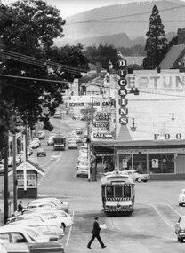 Ballarat Tramway Museum
Photograph - Black & White Photograph/s, Peter Bruce, Digital image - "City Loop and Bridge St", 1971
... Black and white photograph of SEC No. 31 and two other single truckers in the City Loop at the bottom end of Sturt St. near Grenville St and another single trucker in Bridge St. heading west, just after leaving the junction with Main and Victoria Sts. Has the Grenville St. tramway shelter. Telephoto lens used from about the intersection with Lydiard St. looking east. Has "Dickins" store and other shops...Ballarat Tramway Museum South Gardens Reserve Wendouree Parade Ballarat Ballarat goldfields Yields information about the buildings and trams in view from Lydiard St looking east along Bridge St. trams tramways Sturt St City Loop Bridge St Dickins tram 31 Black and white photograph of SEC No. 31 and two other single truckers in the City Loop at the bottom end of Sturt St. near Grenville St and another single trucker in Bridge St. heading west, just after leaving the junction with Main and Victoria Sts. Has the Grenville St. tramway shelter. Telephoto lens used from about the intersection with Lydiard St. looking east. Has "Dickins" store and other shops ...Yields information about the buildings and trams in view from Lydiard St looking east along Bridge St.Black and white photograph of SEC No. 31 and two other single truckers in the City Loop at the bottom end of Sturt St. near Grenville St and another single trucker in Bridge St. heading west, just after leaving the junction with Main and Victoria Sts. Has the Grenville St. tramway shelter. Telephoto lens used from about the intersection with Lydiard St. looking east. Has "Dickins" store and other shops in the background. Tram 31 shows the destination of City and has a Twin Lakes sign as well. Photograph by Peter Bruce, 1971. Digital image added 7/7/10. Peter Bruce title "City Loop and Bridge St"trams, tramways, sturt st, city loop, bridge st, dickins, tram 31 -
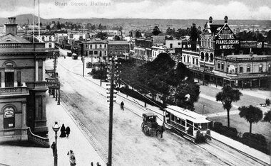 Ballarat Tramway Museum
Photograph - Black & White Photograph/s, c1905
... east. Photo taken soon after opening as tram is not fitted with a destination box. Has horse drawn vehicle and person on bicycle travelling up hill alongside the tram indicating traffic arrangements at the time. Post office steps in photograph as well as Sutton store, Yankee Doodle store and Morris draper shop. Photo title "Sturt St. Ballarat". Another two tramcars at end...east. Photo taken soon after opening as tram is not fitted with a destination box. Has horse drawn vehicle and person on bicycle travelling up hill alongside the tram indicating traffic arrangements at the time. Post office steps in photograph as well as Sutton store, Yankee Doodle store and Morris draper shop. Photo title "Sturt St. Ballarat". Another two tramcars at end ...Black and white print with negative (N148) of an ESCo tram descending the Sturt St. hill from Lydiard St. North towards Grenville St. Photograph taken from possibly the post office. looking south east. Photo taken soon after opening as tram is not fitted with a destination box. Has horse drawn vehicle and person on bicycle travelling up hill alongside the tram indicating traffic arrangements at the time. Post office steps in photograph as well as Sutton store, Yankee Doodle store and Morris draper shop. Photo title "Sturt St. Ballarat". Another two tramcars at end of Bridge St. Copy negative and photograph by John Phillips of a Postcard High Res Images added 5/3/2011. Original neg scanned at hi res and updated 11/5/2020.trams, tramways, sturt st, esco, grenville st, bridge st -
 Ballarat Tramway Museum
Slide - 35mm slide/s - set of 3, Dave Simpson, late 1960's early 1970's
... shop is a letter box and telephone Box. The tram stop sign has a "End of Section" sign. A lady is boarding the tram. .3 - View form the top of the hill looking East towards Main Road with the Fire Station in the Background. ...shop is a letter box and telephone Box. The tram stop sign has a "End of Section" sign. A lady is boarding the tram. .3 - View form the top of the hill looking East towards Main Road with the Fire Station in the Background. ...Yields information about Barkly St Mt PleasantSet of three 35mm slides - AGFA dark blue / white plastic mounts or a Anscochrome white plastic slide of trams in Barkly St, Mount Pleasant. .1 - No. 11 inbound to Gardens via Drummond St, with the Ballarat Fire station in the distant background. Tram has a Twin Lakes sign on the rear. On the left hand side is a sign for "Mobil Anti wear" petrol. .2 - No. 11 inbound to Gardens via Drummond St, at the intersection with Grant St. On the left hand side is a Butchers shop and a Milk bar mixed Grocery shop. The shop has a advert for Woman's Weekly. Along side the shop is a letter box and telephone Box. The tram stop sign has a "End of Section" sign. A lady is boarding the tram. .3 - View form the top of the hill looking East towards Main Road with the Fire Station in the Background. Has a tram in the distance.tramways, trams, barkly st, grant st, mt pleasant, fire station, tram 11 -
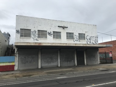 Sunshine and District Historical Society Incorporated
Photograph - Sunshine Photographs 2021 Part 3, John Alchin, 2021
... 5617.01 - Hampshire Rd 122 - 126 Sunshine - Former Shops and Timber Yard2021 Photo 01.JPG 5617.02 - Hampshire Rd 130 Sunshine - Centre Com (Former Picture Theatre) 2021 Photo 01.JPG 5617.03 - Hampshire Rd 134 - Car Yard 2021 Photo 01.JPG 5617.04 - Hampshire Rd 134 - Car Yard 2021 Photo 03.JPG 5617.05 - Hampshire Rd 195 Sunshine 2021 Photo 01.JPG 5617.06 - Hampshire Rd 215 - 219 Sunshine 2021.JPG 5617.07 - Hampshire Rd 215 - 221A Sunshine 2021 Photo 01.JPG 5617.08 - Hampshire Rd 215 - 221A Sunshine 2021 Photo 02.JPG 5617.09 - Hampshire Rd 215 - 221A Sunshine 2021 Photo 05.JPG 5617.10 - Hampshire Rd 234 - 236 Sunshine - Shops 2021 Photo 01.JPG 5617.11 - Hampshire Rd 237 Sunshine 2021 Photo 01.JPG 5617.12 - Hampshire Rd 240 - 242 Sunshine Photo 01.JPG 5617.13 - Hampshire Rd 240 - 252 Sunshine 2021 Photo 01.JPG 5617.14 - Hampshire Rd 254 Sunshine - Former Coles Site 2021 Photo 01.JPG 5617.15 - Hampshire Rd 260 - 280 Sunshine 2021 Photo 01.JPG 5617.16 - Hampshire Rd 330 Sunshine - Tobin Brothers (Former Fire Station) 2021 Photo 01.JPG 5617.17 - Hampshire Rd Sunshine - Brimbank Community and Civic Centre 2021 Photo 02.JPG 5617.18 - Hampshire Rd Sunshine - Brimbank Community and Civic Centre 2021 Photo 01.JPG 5617.19 - Rd Sunshine - Brimbank Council Offices Hampshire Rd Sunshine 2021 Photo 01.JPG 5617.20 - Hampshire Rd Sunshine - Church of Christ Elias Church of St the Prophet Greek-Melkite 2021 Photo 01.JPG 5617.21 - Hampshire Rd Sunshine - Lynch Gardens 2021 Photo 01.JPG 5617.22 - Hampshire Rd Sunshine - Lynch Gardens 2021 Photo 02.JPG 5617.23 - Hampshire Rd Sunshine - Lynch Gardens 2021 Photo 04.JPG 5617.24 - Hampshire Rd Sunshine - Lynch Gardens 2021 Photo 05.JPG 5617.25 - Hampshire Rd Sunshine 2021 Photo 02.JPG 5617.26 - Hampshire Rd Sunshine North - East Cnr Dickson St 2021 Photo 01.JPG 5617.27 - Hamsphire Rd 122 Sunshine - Former Shops And Timber Yard 2021 Photo 01.JPG 5617.28 - Hertford Rd 20 Sunshine - Former SEVC Office 2021 Photo 01.JPG 5617.29 - Hertford Rd 110 Sunshine - Former Shop 2021 Photo 01.JPG 5617.30 - Kororoit Creek At End Of Morris St Sunshine 2021 Photo 01.JPG 5617.31 - Fraser St 27 - 33 Sunshine - Kingdom Hall of Jehovah's Witnesses (Former Bus Depot) 2021 Photo 01.JPG 5617.32 - Kororoit Creek Couper-Angus Grove Sunshine Swimming Hole 2021 Photo 01.JPG 5617.33 - Kororoit Creek South Of Derby Rd Sunshine 2021 Photo 01.JPG 5617.34 - Kororoit Creek Trail Sign Anderson Rd 2021 Photo 02.JPG 5617.35 - McIntosh St Sunshine Looking East 2021 Photo 01.JPG 5617.36 - McIntosh St Sunshine Looking West 2021 Photo 01.JPG 5617.37 - Monash St 96 Sunshine 2021 Photo 01.JPG 5617.38 - Monash St 106 Sunshine 2021 Photo 01.JPG 5617.39 - Monash St 106 Sunshine 2021 Photo 02.JPG 5617.40 - Devonshire Rd 51 Sunshine - Nelson Bros Funeral 2021 Photo 01.JPG ...Sunshine Hampshire Road Hertford Road McIntosh street Monash Street Devonshire Road Centrecom Tobin Brothers Brimbank Community And Civic Centre Brimbank Council Offices Church of Christ Elias Church of St the Prophet Greek-Melkite Lynch Gardens Kingdom Hall of Jehovah's Witnesses Couper-Angus Grove Nelson Bros 5617.01 - Hampshire Rd 122 - 126 Sunshine - Former Shops and Timber Yard2021 Photo 01.JPG 5617.02 - Hampshire Rd 130 Sunshine - Centre Com (Former Picture Theatre) 2021 Photo 01.JPG 5617.03 - Hampshire Rd 134 - Car Yard 2021 Photo 01.JPG 5617.04 - Hampshire Rd 134 - Car Yard 2021 Photo 03.JPG 5617.05 - Hampshire Rd 195 Sunshine 2021 Photo 01.JPG 5617.06 - Hampshire Rd 215 - 219 Sunshine 2021.JPG 5617.07 - Hampshire Rd 215 - 221A Sunshine 2021 Photo 01.JPG 5617.08 - Hampshire Rd 215 - 221A Sunshine 2021 Photo 02.JPG 5617.09 - Hampshire Rd 215 - 221A Sunshine 2021 Photo 05.JPG 5617.10 - Hampshire Rd 234 - 236 Sunshine - Shops 2021 Photo 01.JPG 5617.11 - Hampshire Rd 237 Sunshine 2021 Photo 01.JPG 5617.12 - Hampshire Rd 240 - 242 Sunshine Photo 01.JPG 5617.13 - Hampshire Rd 240 - 252 Sunshine 2021 Photo 01.JPG 5617.14 - Hampshire Rd 254 Sunshine - Former Coles Site 2021 Photo 01.JPG 5617.15 - Hampshire Rd 260 - 280 Sunshine 2021 Photo 01.JPG 5617.16 - Hampshire Rd 330 Sunshine - Tobin Brothers (Former Fire Station) 2021 Photo 01.JPG 5617.17 - Hampshire Rd Sunshine - Brimbank Community and Civic Centre 2021 Photo 02.JPG 5617.18 - Hampshire Rd Sunshine - Brimbank Community and Civic Centre 2021 Photo 01.JPG 5617.19 - Rd Sunshine - Brimbank Council Offices Hampshire Rd Sunshine 2021 Photo 01.JPG 5617.20 - Hampshire Rd Sunshine - Church of Christ Elias Church of St the Prophet Greek-Melkite 2021 Photo 01.JPG 5617.21 - Hampshire Rd Sunshine - Lynch Gardens 2021 Photo 01.JPG 5617.22 - Hampshire Rd Sunshine - Lynch Gardens 2021 Photo 02.JPG 5617.23 - Hampshire Rd Sunshine - Lynch Gardens 2021 Photo 04.JPG 5617.24 - Hampshire Rd Sunshine - Lynch Gardens 2021 Photo 05.JPG 5617.25 - Hampshire Rd Sunshine 2021 Photo 02.JPG 5617.26 - Hampshire Rd Sunshine North - East Cnr Dickson St 2021 Photo 01.JPG 5617.27 - Hamsphire Rd 122 Sunshine - Former Shops And Timber Yard 2021 Photo 01.JPG 5617.28 - Hertford Rd 20 Sunshine - Former SEVC Office 2021 Photo 01.JPG 5617.29 - Hertford Rd 110 Sunshine - Former Shop 2021 Photo 01.JPG 5617.30 - Kororoit Creek At End Of Morris St Sunshine 2021 Photo 01.JPG 5617.31 - Fraser St 27 - 33 Sunshine - Kingdom Hall of Jehovah's Witnesses (Former Bus Depot) 2021 Photo 01.JPG 5617.32 - Kororoit Creek Couper-Angus Grove Sunshine Swimming Hole 2021 Photo 01.JPG 5617.33 - Kororoit Creek South Of Derby Rd Sunshine 2021 Photo 01.JPG 5617.34 - Kororoit Creek Trail Sign Anderson Rd 2021 Photo 02.JPG 5617.35 - McIntosh St Sunshine Looking East 2021 Photo 01.JPG 5617.36 - McIntosh St Sunshine Looking West 2021 Photo 01.JPG 5617.37 - Monash St 96 Sunshine 2021 Photo 01.JPG 5617.38 - Monash St 106 Sunshine 2021 Photo 01.JPG 5617.39 - Monash St 106 Sunshine 2021 Photo 02.JPG 5617.40 - Devonshire Rd 51 Sunshine - Nelson Bros Funeral 2021 Photo 01.JPG Large collection of digital photographs that have be split over five identification numbers. ...These photographs provide a visual record of assorted buildings, street views, and notable locations throughout Sunshine in 2021.This collection of photographs preserves a visual record of Sunshine 2021.5617.01 - Hampshire Rd 122 - 126 Sunshine - Former Shops and Timber Yard2021 Photo 01.JPG 5617.02 - Hampshire Rd 130 Sunshine - Centre Com (Former Picture Theatre) 2021 Photo 01.JPG 5617.03 - Hampshire Rd 134 - Car Yard 2021 Photo 01.JPG 5617.04 - Hampshire Rd 134 - Car Yard 2021 Photo 03.JPG 5617.05 - Hampshire Rd 195 Sunshine 2021 Photo 01.JPG 5617.06 - Hampshire Rd 215 - 219 Sunshine 2021.JPG 5617.07 - Hampshire Rd 215 - 221A Sunshine 2021 Photo 01.JPG 5617.08 - Hampshire Rd 215 - 221A Sunshine 2021 Photo 02.JPG 5617.09 - Hampshire Rd 215 - 221A Sunshine 2021 Photo 05.JPG 5617.10 - Hampshire Rd 234 - 236 Sunshine - Shops 2021 Photo 01.JPG 5617.11 - Hampshire Rd 237 Sunshine 2021 Photo 01.JPG 5617.12 - Hampshire Rd 240 - 242 Sunshine Photo 01.JPG 5617.13 - Hampshire Rd 240 - 252 Sunshine 2021 Photo 01.JPG 5617.14 - Hampshire Rd 254 Sunshine - Former Coles Site 2021 Photo 01.JPG 5617.15 - Hampshire Rd 260 - 280 Sunshine 2021 Photo 01.JPG 5617.16 - Hampshire Rd 330 Sunshine - Tobin Brothers (Former Fire Station) 2021 Photo 01.JPG 5617.17 - Hampshire Rd Sunshine - Brimbank Community and Civic Centre 2021 Photo 02.JPG 5617.18 - Hampshire Rd Sunshine - Brimbank Community and Civic Centre 2021 Photo 01.JPG 5617.19 - Rd Sunshine - Brimbank Council Offices Hampshire Rd Sunshine 2021 Photo 01.JPG 5617.20 - Hampshire Rd Sunshine - Church of Christ Elias Church of St the Prophet Greek-Melkite 2021 Photo 01.JPG 5617.21 - Hampshire Rd Sunshine - Lynch Gardens 2021 Photo 01.JPG 5617.22 - Hampshire Rd Sunshine - Lynch Gardens 2021 Photo 02.JPG 5617.23 - Hampshire Rd Sunshine - Lynch Gardens 2021 Photo 04.JPG 5617.24 - Hampshire Rd Sunshine - Lynch Gardens 2021 Photo 05.JPG 5617.25 - Hampshire Rd Sunshine 2021 Photo 02.JPG 5617.26 - Hampshire Rd Sunshine North - East Cnr Dickson St 2021 Photo 01.JPG 5617.27 - Hamsphire Rd 122 Sunshine - Former Shops And Timber Yard 2021 Photo 01.JPG 5617.28 - Hertford Rd 20 Sunshine - Former SEVC Office 2021 Photo 01.JPG 5617.29 - Hertford Rd 110 Sunshine - Former Shop 2021 Photo 01.JPG 5617.30 - Kororoit Creek At End Of Morris St Sunshine 2021 Photo 01.JPG 5617.31 - Fraser St 27 - 33 Sunshine - Kingdom Hall of Jehovah's Witnesses (Former Bus Depot) 2021 Photo 01.JPG 5617.32 - Kororoit Creek Couper-Angus Grove Sunshine Swimming Hole 2021 Photo 01.JPG 5617.33 - Kororoit Creek South Of Derby Rd Sunshine 2021 Photo 01.JPG 5617.34 - Kororoit Creek Trail Sign Anderson Rd 2021 Photo 02.JPG 5617.35 - McIntosh St Sunshine Looking East 2021 Photo 01.JPG 5617.36 - McIntosh St Sunshine Looking West 2021 Photo 01.JPG 5617.37 - Monash St 96 Sunshine 2021 Photo 01.JPG 5617.38 - Monash St 106 Sunshine 2021 Photo 01.JPG 5617.39 - Monash St 106 Sunshine 2021 Photo 02.JPG 5617.40 - Devonshire Rd 51 Sunshine - Nelson Bros Funeral 2021 Photo 01.JPG sunshine, hampshire road, hertford road, mcintosh street, monash street, devonshire road, centrecom, tobin brothers, brimbank community and civic centre, brimbank council offices, church of christ elias church of st the prophet greek-melkite, lynch gardens, kingdom hall of jehovah's witnesses, couper-angus grove, nelson bros -
 Sunshine and District Historical Society Incorporated
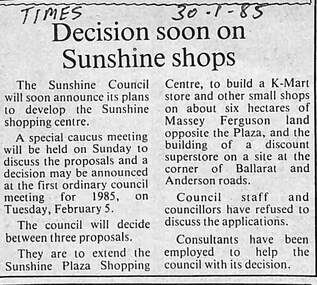
Archive - Sunshine Plaza / Market Place Development
... shopping complex. After complex discussions between developers, the site owners, councillors, consultants, legal advice and with the Victorian Government, the Council was forced to sell the site to private developers. The Victorian State Government stepped in and prevented the City of Sunshine in becoming the developers of the site due to the possible exposure to large amounts of financial debts. In the end, Sunshine ended up with two distinct shopping complexes, the Sunshine Plaza on the east ...The former Massey Ferguson site became a contentious issue for the City of Sunshine from the mid 1980's. The Council had acquired the land from Massey Ferguson and were considering developing the land into a large shopping complex. After complex discussions between developers, the site owners, councillors, consultants, legal advice and with the Victorian Government, the Council was forced to sell the site to private developers. The Victorian State Government stepped in and prevented the City of Sunshine in becoming the developers of the site due to the possible exposure to large amounts of financial debts. In the end, Sunshine ended up with two distinct shopping complexes, the Sunshine Plaza on the east side of Hampshire Road, which is also on former Massey Ferguson land, and the Sunshine Market Place, on the west side of Hampshire Road, the large site of the former Massey Ferguson manufacturing site. Both sites are now privately owned.5691.01 - Sunshine Plaza Development - Decision Soon On Sunshine Shops.jpg 5691.02 - Sunshine Plaza Development - Advice.jpg 5691.03 - Sunshine Plaza Development - Council May Become A Developer.jpg 5691.04 - Sunshine Plaza Development - Judge To Rule On Shop Site.jpg 5691.05 - Sunshine Plaza Development - Outspoken Plaza Boss To Stand For Council.jpg 5691.06 - Sunshine Plaza Development - Gwen Goedecke Letter Of Concerns 1989 Back.jpg 5691.06 - Sunshine Plaza Development - Gwen Goedecke Letter Of Concerns 1989 Front.jpg sunshine plaza, city of sunshine, george herscue, massey ferguson, sunshine market place, gwen goedecke -
 Clunes Museum
Photograph, BLACK PHOTO
... PHOTOGRAPH OF LOWER END FRASER STREET CLUNES LOOKING EAST, HORSE AND DRAY IN STREET. PHOTOGRAPH SHOWS BUTCHER SHOP, SEVEN STARS HOTEL, DOWNES RESIDENCE WAS SHAMROCK HOTEL SYMONS IRONMONGERS STORE TIMBER YARD. ...Clunes Museum 36 Fraser Street enter building through Collins Place Clunes goldfields local history photography photographs shops symons ironmongers store seven stars hotel shamrock hotel luckraft hotel commercial hotel . township - hotels PHOTOGRAPH OF LOWER END FRASER STREET CLUNES LOOKING EAST, HORSE AND DRAY IN STREET. ...PHOTOGRAPH OF LOWER END FRASER STREET CLUNES LOOKING EAST, HORSE AND DRAY IN STREET. PHOTOGRAPH SHOWS BUTCHER SHOP, SEVEN STARS HOTEL, DOWNES RESIDENCE WAS SHAMROCK HOTEL SYMONS IRONMONGERS STORE TIMBER YARD. [LUCKRAFT HOTEL, COMMERCIAL HOTEL] TAKEN ABOUT 1899 .1 BLACK AND WHITE PHOTO PRINT .2 ENLARGED PHOTO PRINT .3 SEPIA PHOTOGRAPH MOUNTED ON MATT BOARD WITH LOCATION WRITTEN AROUND PHOTOlocal history, photography, photographs, shops, symons ironmongers store, seven stars hotel, shamrock hotel, luckraft hotel, commercial hotel ., township - hotels -
 Clunes Museum
Photograph, CIRCA 1860 - 1892
... FRASER STREET. 1860- 1892 shops red boot palace clunes township CLUNES VIC. PHOTOGRAPH OF FRASER STREET, LOOKING TOWARDS THE EAST END, AND THE ANZ BANK. ...THE DONOR OF THIS PHOTOGRAPH IS A DESCENDENT OF J.S. MULCAHY, BOOT STORE. FRASER STREET. 1860- 1892PHOTOGRAPH OF FRASER STREET, LOOKING TOWARDS THE EAST END, AND THE ANZ BANK. THE RED BOOT PALACE IS FIRST 2 STOREY BUILDING ON THE RIGHT.CLUNES VIC.shops, red boot palace, clunes township -
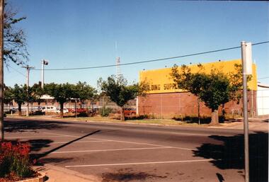 Hume City Civic Collection
Photograph, Mid 1990's
... end of Evans Street and in the past were away from the main shopping centre. As Sunbury expanded and Sunbury Shopping Square was built on the opposite side of Evans Street, the building suppliers closed down and the CFA depot was moved out of the town centre to two other locations to avoid traffic conjestion. building suppliers shopping centres sunbury country fire authority (cfa) evans street george evans collection A coloured photograph of the east side of Evans Street showing the building suppliers yard and the Sunbury CFA station and towers. ...The building suppliers and the Sunbury CFA were sited at the northern end of Evans Street and in the past were away from the main shopping centre. As Sunbury expanded and Sunbury Shopping Square was built on the opposite side of Evans Street, the building suppliers closed down and the CFA depot was moved out of the town centre to two other locations to avoid traffic conjestion.A coloured photograph of the east side of Evans Street showing the building suppliers yard and the Sunbury CFA station and towers. The road in the foreground has been marked out for angle parking. There is a metal pole on the extreme RHS of the photograph.building suppliers, shopping centres, sunbury country fire authority (cfa), evans street, george evans collection -
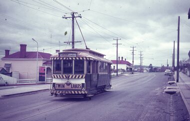
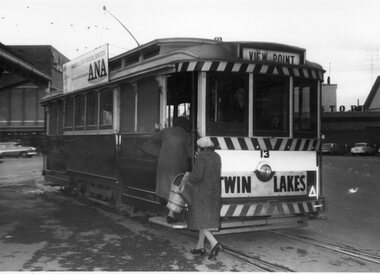 Ballarat Tramway Museum
Photograph - Black & White Photograph/s, The Courier Ballarat, 19/07/1968 12:00:00 AM
... east end of Sturt St, advertisements on the tram and the way the stop was used. tramways trams Bridge St Grenville St Sturt St Twin Lakes tram 13 On rear stamped "Copyright, The Ballarat Courier Proprietary Limited." Black and White copy photograph of a newspaper photograph taken by The Courier, published 19/7/1968 of No. 13 picking up passengers, Sturt & Grenville Sts corner, after Govt announced intention to close Ballarat & Bendigo systems. Tram has the destination of View Point, a "Twin Lakes" sign and a roof advertisement for ANA medical services. Two lady passengers, one with a shopping ...Yields information about the tram stop at the east end of Sturt St, advertisements on the tram and the way the stop was used.Black and White copy photograph of a newspaper photograph taken by The Courier, published 19/7/1968 of No. 13 picking up passengers, Sturt & Grenville Sts corner, after Govt announced intention to close Ballarat & Bendigo systems. Tram has the destination of View Point, a "Twin Lakes" sign and a roof advertisement for ANA medical services. Two lady passengers, one with a shopping basket boarding the tram. In the background are Morsheads and Dickins stores. See Reg Item 2921 for the Newspaper cutting the photograph used in. Collected by Alan Bradley from the Ballarat Courier early 1980's. See Excel file "Record of Ballarat Courier Photos SEC era" (Archive Documents) for source of details.On rear stamped "Copyright, The Ballarat Courier Proprietary Limited."tramways, trams, bridge st, grenville st, sturt st, twin lakes, tram 13 -
 Whitehorse Historical Society Inc.
Photograph, Whitehorse Road, Mitcham, 1/10/2000 12:00:00 AM
... Coloured photograph of Whitehorse Road, Mitcham, looking east taken from western end of shopping centre opposite old police station....Coloured photograph of Whitehorse Road, Mitcham, looking east taken from western end of shopping centre opposite old police station. ...Coloured photograph of Whitehorse Road, Mitcham, looking east taken from western end of shopping centre opposite old police station.whitehorse road, mitcham, mitcham. -
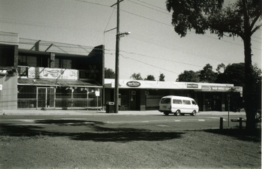
 Whitehorse Historical Society Inc.
Photograph - Strip Photos and photo copy, Railway Road Blackburn, 1/08/1976 12:00:00 AM
... Whitehorse Historical Society Inc. 2-10 Deep Creek Road Mitcham melbourne Railway Road Blackburn east end in August 1976. Railway Road Blackburn Shops One strip photo and one photocopy. ...Railway Road Blackburn east end in August 1976.One strip photo and one photocopy.railway road, blackburn, shops -
 Whitehorse Historical Society Inc.
Photograph - Strip photo and photocopy, Railway Road Blackburn, 1/08/1976 12:00:00 AM
... Whitehorse Historical Society Inc. 2-10 Deep Creek Road Mitcham melbourne Railway Road Blackburn. East end. Blackburn Railway Road Shops Railway Road Blackburn. ...Railway Road Blackburn. East end.Railway Road Blackburn. East End.blackburn, railway road, shops