Showing 19 items matching "eastern reefs"
-
 Federation University Historical Collection
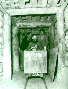
Photograph - Black and White, 1988, Three men standing behind a trolley in a mine tunnel, 06/1988
... ...eastern reefs...This image was taken at the conclusion of a special eight week "Crash course" in mining, requested by Eastern Reefs. It was used in the Ballarat School of Mines Review, 1988, page 7....Barker Library (top floor) Mount Helen goldfields This image was taken at the conclusion of a special eight week "Crash course" in mining, requested by Eastern Reefs. It was used in the Ballarat School of Mines Review, 1988, page 7. ballarat school of mines mines mining mining trolley mine truck mining railway malcolm vallance mal vallance raymond collins ernie terrill eastern reefs Sovereign hill mining education Black and white image of three men standing behind a trolley in a mine tunnel showing supporting beams (thought to be Sovereign Hill) They are from left to right Ernie Terrill (Ballarat CES), Raymond Collins (Ballarat School of Mines Mining Student) and Malcolm Vallance (Ballarat School of Mines Special Projects Manager). ...This image was taken at the conclusion of a special eight week "Crash course" in mining, requested by Eastern Reefs. It was used in the Ballarat School of Mines Review, 1988, page 7.Black and white image of three men standing behind a trolley in a mine tunnel showing supporting beams (thought to be Sovereign Hill) They are from left to right Ernie Terrill (Ballarat CES), Raymond Collins (Ballarat School of Mines Mining Student) and Malcolm Vallance (Ballarat School of Mines Special Projects Manager).ballarat school of mines, mines, mining, mining trolley, mine truck, mining railway, malcolm vallance, mal vallance, raymond collins, ernie terrill, eastern reefs, sovereign hill, mining education -
 Bendigo Historical Society Inc.
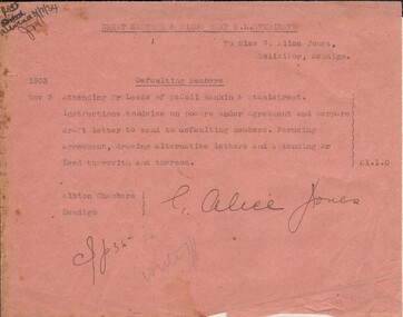
Document - MISS G ALICE JONES COLLECTION: ACCOUNT
... ... Great Eastern & Birds Reef N L Syndicte...Great Eastern & Birds Reef N. L. Syndicate to Miss G. Alice Jones. ...Alice Jones - Solicitor - Account Great Eastern & Birds Reef N L Syndicte Mr Leeds McColl Rankin & Stanistreet Great Eastern & Birds Reef N. ...Great Eastern & Birds Reef N. L. Syndicate to Miss G. Alice Jones. Pink paper dated Nov 3 1933. Re Defaulting Members. Cost £1.1.0. "R693 delivered 3/7/34" written in the top left corner.miss g. alice jones - solicitor - account, great eastern & birds reef n l syndicte, mr leeds mccoll rankin & stanistreet -
 Federation University Historical Collection
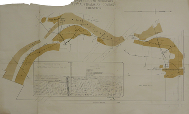
Plan, Underground Workings New Australasian Company Creswick, not dated
... ...reef wash...eastern...It als shows the locations of the Red streak or Australasian Gutter, Reef wash, Eastern Wash, Australasian and Eaglehawk Shaft and prospecting drives....It als shows the locations of the Red streak or Australasian Gutter, Reef wash, Eastern Wash, Australasian and Eaglehawk Shaft and prospecting drives. ...A plan of the underground working of the New Australasian Mine at Creswick, showing Wheeler's Bridge Road, a transverse section on the West Main Reef Drive and Line AB. It als shows the locations of the Red streak or Australasian Gutter, Reef wash, Eastern Wash, Australasian and Eaglehawk Shaft and prospecting drives.mining, plans, cgt, creswick, new australasian company, wheeler's bridge, red streak gutter, australasian gutter, reef wash, eastern wash, australiasian shaft, eaglehawk shaft -
 Bendigo Historical Society Inc.
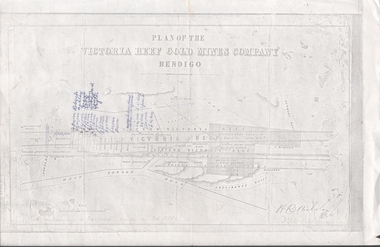
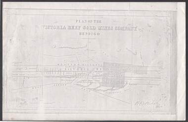
Document - VICTORIA HILL - PLAN OF THE VICTORIA REEF GOLD MINES COMPANY
... Plan of the Victoria Reef Gold Mines Company, Bendigo showing the Eastern Victoria Reef, Victoria Reef and the Western Victoria Reef. ...Co and Wheadon Plan of the Victoria Reef Gold Mines Company, Bendigo showing the Eastern Victoria Reef, Victoria Reef and the Western Victoria Reef. ...Plan of the Victoria Reef Gold Mines Company, Bendigo showing the Eastern Victoria Reef, Victoria Reef and the Western Victoria Reef. Streets, gullies and leases drawn in. Some amounts of money and names have been written on the page. Signed by H. B. Nicholas. Locations of Ballerstedt's, Luffsman's, Wittscheibe's, Midway Co and Rae's engines are shown. Ironbark, Derwent, Providence and Long Gullies are shown. Also Mount Korong Road. Leases mentioned are: Jackson, Burrows, Wybarndt, Ballerstedt, Luffsman, Roberts, Ashley, Grant, Troy, Tezeau, Woodward, Croath, Taylor, Cranshaw, Gou?d & Co, Midway, Wittscheibe, Specimen Hill Co, Endeavour, Albert Co, Ballerstedt & Son, Hy? Co, and Wheadon.document, gold, victoria hill, plan of the victoria reef gold mines company, h b nicholas, spiers, jackson, burrows, wybarndt, ballerstedt, luffsman, roberts, ashley, grant, troy, tezeau, woodward, croath, taylor, cranshaw, gou?d & co, midway, wittscheibe, specimen hill co, endeavour, albert co, ballerstedt & son, hy? co, and wheadon -
 Bendigo Historical Society Inc.
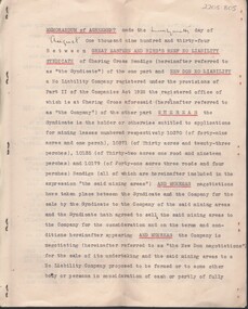
Document - MCCOLL, RANKIN AND STANISTREET COLLECTION: MEMORANDUM OF AGREEMENT GREAT EASTERN AND BIRDS REEF, 10/2/1933
... MCCOLL, RANKIN AND STANISTREET COLLECTION: MEMORANDUM OF AGREEMENT GREAT EASTERN AND BIRDS REEF...... Great Eastern and Birds Reef No Liability syndicate...Memorandum of agreement between Great Eastern and Birds Reef No Liability syndicate and New Don No Liability. ...Memorandum of agreement between Great Eastern and Birds Reef No Liability syndicate and New Don No Liability. ...Document: McColl, Rankin & Stanistreet , 7 page document, typed, prepared by Ford Aspinwall & DeGruchy, Solicitors, Melbourne. Memorandum of agreement between Great Eastern and Birds Reef No Liability syndicate and New Don No Liability. Signed under common seal of New Don James Barclay and Geo. Kingsley ( director ) and Stanistreet ( legal manager ) Also asigned by Jack Reginald Ingram, Thomas Watson Haynes and Henry George De Gruchy.organization, business, new don no liability, mccoll, rankin & stanistreet , great eastern and birds reef no liability syndicate, new don no liability, bendigo, gold, goldmining, lease -
 Bendigo Historical Society Inc.
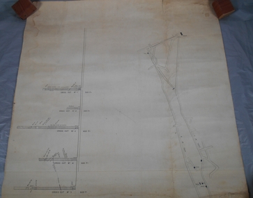
Document - VICTORIA REEF GOLD MINES COMPANY BENDIGO PLAN
... Between the Eastern Victoria Reef and the Prince Albert Reef is the White Lead. ...Between the Eastern Victoria Reef and the Prince Albert Reef is the White Lead. ...Photocopy of a Plan of the Victoria Reef Gold Mines Company, Bendigo. Shaded area is the Victoria Reef Gold Mines Company Lease No. 2 and Lease No. 3. The gullies are named Happy Valley, Long, Derwent, Providence and Ironbark Gullies. The reefs are: Western Victoria, Victoria, Eastern Victoria and Prince Albert Reef. Between the Eastern Victoria Reef and the Prince Albert Reef is the White Lead. Mount Korong Road is at the bottom of the plan. Other Leaseholders are: Burrows, Wybrant, Ballerstedt, Jackson,Roberts & Co, Ashley, Grant, ?rpe, ?eau, Woodward, Coath, Taylor, Cranshaw, Roberts, Gould & Co, Midway, Witscheibe, Endeavour Co, Albert Co, Ballerstedt & Son, Late Iron Bark Quartz Mining Co, McDougall, Specimen Hill Co, Hygrect?, Wheadon, Evans and Bannerman. Signed by H. B. Nicholas. Location of Ballerstedt, Luffsman, Midway Co, Witscheibe and Rae & Co engine locations. Hills are shown as hatch shading. Written at the bottom left ocrner is: Accompanying prospectus issued in Nov. 1859. Signed H.B. Nicholas.plan, bendigo, victoria reef gold mines company, victoria reef gold mines company bendigo - plan, h b nicholas, burrows, wybrant, ballerstedt, jackson, roberts & co, ashley, grant, ?rpe, ?eau, woodward, coath, taylor, cra-shaw, roberts, gou-d & co, midway, witscheibe, endeavour co, albert co, ballerstedt & son, late iron bark quartz mining co, mcdougall, specimen hill co, hyo?, wheadon, evans, bannerman. -
 Bendigo Historical Society Inc.
Plan - South Frederick The Great Mine, Sebastian
... Reef, Sebastian Map Reference Raywood 1:25000 - BV488.447 Mine site: Capped shaft still surrounded by its mullock paddock. At the base of the paddock on the northern side is a concrete winding engine foundation measuring 8 by 4 feet, and standing 2 feet high. The foundation has ¾-inch mounting bolts. Battery site 70 metres to the west of the mine site are the concrete foundations of a 10head battery. The foundations measure 16 by 11 feet, and stand 4 feet high. Part of the battery's loading ramp still survives, and on the eastern...Reef, Sebastian Map Reference Raywood 1:25000 - BV488.447 Mine site: Capped shaft still surrounded by its mullock paddock. At the base of the paddock on the northern side is a concrete winding engine foundation measuring 8 by 4 feet, and standing 2 feet high. The foundation has ¾-inch mounting bolts. Battery site 70 metres to the west of the mine site are the concrete foundations of a 10head battery. The foundations measure 16 by 11 feet, and stand 4 feet high. Part of the battery's loading ramp still survives, and on the eastern ...SOUTH FREDERICK THE GREAT MINE Location Unreserved Crown Land along the southern boundary of Sebastian School, east of Three Chain Road, Frederick the Great/Carshalton Reef, Sebastian Map Reference Raywood 1:25000 - BV488.447 Mine site: Capped shaft still surrounded by its mullock paddock. At the base of the paddock on the northern side is a concrete winding engine foundation measuring 8 by 4 feet, and standing 2 feet high. The foundation has ¾-inch mounting bolts. Battery site 70 metres to the west of the mine site are the concrete foundations of a 10head battery. The foundations measure 16 by 11 feet, and stand 4 feet high. Part of the battery's loading ramp still survives, and on the eastern side of the battery foundations is a large concrete engine foundation. Near this engine foundation is a 3 foot square concrete pad, which still retains a circular impression. Presumably this was a stand for a gas producer cylinder. Located between the battery and the mine site is a rubbish dump which contains sections of an iron stack, and perhaps the remains of the gas producer cylinder. History Period of activity: 1871 (South Frederick the Great); 1881-1889 (Amalgamated South Frederick the Great); 1897-1906 (South Frederick the Great); 1933-1937 (South Frederick the Great) Line of reef: Sebastian/Carshalton Maximum recorded annual production: unknown Total production: 511ozs obtained from 1773 tons between 1934 and 1937 Deepest working level: 300 feet (Amalgamated South Frederick the Great) Deepest shaft: 307 feet (Amalgamated South Frederick the Great)(below water level) Source: City of Greater Bendigo: Marong Heritage Study chrome-extension://efaidnbmnnnibpcajpcglclefindmkaj/http://images.heritage.vic.gov.au/attachment/70493Mining SitesTransverse and longitudinal plans on one sheet, of South Frederick The Great Mine, Sebastian. Forms part of the Margaret Roberts Collection of mining records.bendigo, margaret roberts, gold, south frederick the great mine, margaret roberts collection, sebastian -
 Bendigo Historical Society Inc.
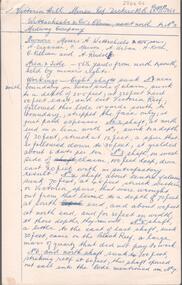
Document - ALBERT RICHARDSON COLLECTION: VICTORIA HILL MINES
... reefs passing through this ground at small intervals in every part of this claim, they all dip north. The mass of leaders struck in No. 4 (shaft) yielded, on an average about 1 1/2 ounces to the ton to the amount, in all, of about 12,000 pounds. From the eastern...reefs passing through this ground at small intervals in every part of this claim, they all dip north. The mass of leaders struck in No. 4 (shaft) yielded, on an average about 1 1/2 ounces to the ton to the amount, in all, of about 12,000 pounds. From the eastern ...Two page handwritten document titled 'Victoria Hill Mines, Dickers M.R. 23.11.1861. Wittschiebe and Co. Claim. Next north to No. 2, Midway Company' Transcribed by Albert Richardson. Extract from text: 'There are reefs passing through this ground at small intervals in every part of this claim, they all dip north. The mass of leaders struck in No. 4 (shaft) yielded, on an average about 1 1/2 ounces to the ton to the amount, in all, of about 12,000 pounds. From the eastern Victoria, the present proprietors extracted in nine months 55,000 pounds worth of gold.' Owners of mine. Messrs A. Witrtschiebe, A. Sagasser, F. Meison, A. Urban, H. Koch, C. Killian and A. Rudolf. Document details the claim, the shafts sunk, their depth, issues re workings and gold found.Albert Richardsonbendigo, mining, wittschiebe & co. claim -
 Bendigo Historical Society Inc.
Document - ALBERT RICHARDSON COLLECTION: TAMBOUR MAJOR AND CHRISTMAS LINE OF REEF
... Eastern and Bismark Coys) 400 ft 1882 Tambour Major 847 feet 1881 - 1890 Christmas Reef Co. 200 ft. 1895 - 1897 Open Cuts...Eastern and Bismark Coys) 400 ft 1882 Tambour Major 847 feet 1881 - 1890 Christmas Reef Co. 200 ft. 1895 - 1897 Open Cuts Document ALBERT RICHARDSON COLLECTION: TAMBOUR MAJOR AND CHRISTMAS LINE OF REEF ...Three page document. Front page, extracts from F. Chamber's Report on Tambour Major Shaft, includes reference to Allingham and Moore's shaft and Specimen Hill Reservoir. Early workings on the Christmas Reef line, Specimen Hill or Tambour Major, are listed in a table format, example - Great Western Gold Mining and Crushing Coy, 1855 Fajeon and Coy, 1859, tunnel in hillside. Specimen Hill Coy 1861 Indefatigable 1862, 64, 67 - 1881 Agamemnon 1862-1863 - 1881 Invincible Co. 1865 - 1867 Old Bendigo Tribute 140 ft 1870 Great Eastern Co 1870 - 1881 Great Eastern Tribute Co. Bismark Co, No. 1 North 150 ft 1870 - 1881 Bismark No. 2 Tribute 212 ft Allingham and Moore 338 ft 1872 Specimen Hill United 450 ft 1881 Great Western United (amalgamation of Old Bendigo, Invincible, Gt. Eastern and Bismark Coys) 400 ft 1882 Tambour Major 847 feet 1881 - 1890 Christmas Reef Co. 200 ft. 1895 - 1897 Open Cutsbendigo, mining, christmas reef gold mining -
 Queenscliffe Maritime Museum
Sign - Metal letter A
... On 21st June 1904, due to pilot error, the Australia hit the notorious Corsair Rock, part of the Point Nepean Reef, on the eastern side of Port Philip heads, opening a gaping 5 meter hole along her keel. ...On 21st June 1904, due to pilot error, the Australia hit the notorious Corsair Rock, part of the Point Nepean Reef, on the eastern side of Port Philip heads, opening a gaping 5 meter hole along her keel. ...The steamship, SS Australia, was built in Greenock, Scotland in 1892, for the P & O Steam Navigation Company. Australia was considered to be one of the most luxurious vessels afloat and she held the speed record from England to Australia at the time. On 21st June 1904, due to pilot error, the Australia hit the notorious Corsair Rock, part of the Point Nepean Reef, on the eastern side of Port Philip heads, opening a gaping 5 meter hole along her keel. Passengers and some of the crew were rescued by craft sent from Queenscliff.Relic from a significant wreck on Corsair Rock at Point NepeanMetal letter A mounted on timber board in front with salvage account on the backAccount of salvage of artefactsign, ships name, ss australia -
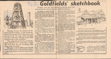 Bendigo Historical Society Inc.
Newspaper - GOLDFIELDS SKETCHBOOK ARTICLE, BENDIGO ADVERTISER, 23rd July 1970
... Eastern Goldfields Sketchbook with Drawings by Unk White and text by John Bechervaise, first published 1970, 64 pages, hardback edition, $1.95. Extract from article ' our poppet-head sketch is of the Deborah superstructure, rising above a shaft 2017 feet deep, the site on Quarry Hill being easily accessible. The mine yielded 52,000 ounces of gold and in 1954 was one of the last three mines all on the Deborah line of reef...Eastern Goldfields Sketchbook with Drawings by Unk White and text by John Bechervaise, first published 1970, 64 pages, hardback edition, $1.95. Extract from article ' our poppet-head sketch is of the Deborah superstructure, rising above a shaft 2017 feet deep, the site on Quarry Hill being easily accessible. The mine yielded 52,000 ounces of gold and in 1954 was one of the last three mines all on the Deborah line of reef ...Newspaper article titled' Goldfields' sketchbook. Article on book release ' Bendigo and Eastern Goldfields Sketchbook with Drawings by Unk White and text by John Bechervaise, first published 1970, 64 pages, hardback edition, $1.95. Extract from article ' our poppet-head sketch is of the Deborah superstructure, rising above a shaft 2017 feet deep, the site on Quarry Hill being easily accessible. The mine yielded 52,000 ounces of gold and in 1954 was one of the last three mines all on the Deborah line of reef, to close down'Bendigo Advertiser July 23rd 1970.bendigo, mining, gold discovery, 'bendigo advertiser -
 Bendigo Historical Society Inc.
Document - TYSON'S LINE - EASTERN LINES
... Eastern Lines... Hustler's... New Chum... Slaughteryard Line... Lightning Hill... Tyson's... Isabella Mine... Ironstone Hill Reef...Reef, on which a mine owned by a man named Stevenson mined a fair amount of gold. Ref. Anon; 1899. Spec. Ed. Aust. Min. Stand. June 1st 1899: p 61. Notes prepared by Albert Richardson. Document TYSON'S LINE - EASTERN ...BHS CollectionTyped carbon copy and typed copy of General notes on the lines East of the Hustlers. Lines mentioned are: Hustler's, New Chum, Lightning Hill, Tysons, Slaughteryard, Isabella Mine, Ironstone Hill Reef, Nicholson Reef, on which a mine owned by a man named Stevenson mined a fair amount of gold. Ref. Anon; 1899. Spec. Ed. Aust. Min. Stand. June 1st 1899: p 61. Notes prepared by Albert Richardson.mining, parish map, tyson's line, eastern lines, hustler's, new chum, slaughteryard line, lightning hill, tyson's, isabella mine, ironstone hill reef, nicholson reef, mr stevenson, aust min stand 1 june 1899 -
 Bendigo Historical Society Inc.
Document - VICTORIA QUARTZ - NOTES ON THE VICTORIA QUARTZ & RAE'S OPEN CUT
... Reef Company... Wm Rae... Eastern...History House 11 Mackenzie Street Bendigo goldfields DOCUMENT Gold victoria quartz Victoria Quartz Notes on the Victoria Quartz & Rae's Open Cut Victoria Reef Company Wm Rae Eastern Victoria Reef Handwritten page and carbon copy of notes on the Victoria Quartz Mine and Rae's Open Cut. ...Handwritten page and carbon copy of notes on the Victoria Quartz Mine and Rae's Open Cut.document, gold, victoria quartz, victoria quartz, notes on the victoria quartz & rae's open cut, victoria reef company, wm rae, eastern victoria reef -
 Bendigo Historical Society Inc.
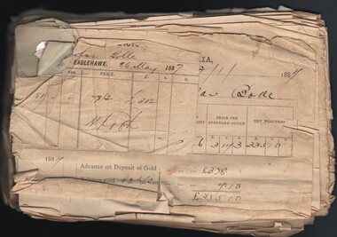
Document - GOLD SALE NOTES FOR NICHOLAS BOLLE, 1868 - 1887
... reef workings there is an area of hydraulic sluicing. West of the cyanide works and along Scotchman Gully there are patches of shallow alluvial workings. Battery site On the eastern...reef workings there is an area of hydraulic sluicing. West of the cyanide works and along Scotchman Gully there are patches of shallow alluvial workings. Battery site On the eastern ...Nicholas John Bolle was born in Dorstadt, Germany in 1836 to parents Heinrich (Johannes Heinrich Wilhelm) and Friederike Hartmann (Anne Marie Friedericke). Around the age of 20 he immigrated to Australia and made his way, most likely on foot, 150km in a northerly direction to the Bendigo goldfields. In March 1863 Nicholas registered his first mining claim, naming it Bolle’s Reef. Having worked this reef until it no longer paid, he went on a prospecting tour of the area and found another gold reef towards Elysian Flat, staked a claim and registered it under the name of his beloved wife ‘Rosanna’. Sadly, as was often the case, the cost of hiring men to get the gold out of the ground, and removing it from the clay and quartz, outweighed the amount of profit he was making from his discoveries. In November 1863 while living and working at Old Tom Gully, Nicholas appeared in the Government Gazette as insolvent. Nicholas continued to struggle on, scoping out the surrounding area in the Whipstick Forest, and having some little success and by 1869 he was given a government reward of 25 pounds for discovering a new area of gold in the Whipstick. The Government Gazette records this reward – 'for the discovery of the Whipstick, 25 pounds' (Government Gazette 1869) By 1872 Nicholas had established a quartz crushing plant at his mine in Old Tom Gully, (the Old Tom mine) a remote place in the middle of the Whipstick. Mining was a dangerous business, and in 1875 Nicholas was called as a witness in a coroner’s inquest into the death of a John Bashton who was accidentally killed in a mining accident at nearby Easter Claim in December. In 1881, he was again called to give evidence when one of his employees Mr Thomas Garrett was killed while working at his claim at Old Tom Reef. So we are fortunate to have Nicholas describing his day’s work in his own words. Reference: Michelle Dennis Family History http://www.michelledennis.com.au/?page_id=1067) The Old Tom Mine site is situated between Old Tom Road, Scotsman Road, Eaglehawk-Neilborough Road and an unnamed road, Whipstick VIC 3556. The Marong Heritage Study, Mining Sites ( City of Greater Bendigo) describes the former mine site as follows: '40 metre-long mullock heap with one dumping line running north from a filled shaft. The heap has been partially quarried. 20 metres south is a scatter of red hand-made bricks and rough concrete rubble. Further south there are smaller mullock dumps and a line of shallow reef workings Surface workings 30 metres west of the mullock dump, running north, is a line of small mullock paddocks, terminating in a shallow open cut. On the same line to the south, in an area north and west of the most southerly section of reef workings there is an area of hydraulic sluicing. West of the cyanide works and along Scotchman Gully there are patches of shallow alluvial workings. Battery site On the eastern side of the open-cut is a small mullock paddock, below which is a spread of hand-made red bricks and fire bricks. Near this rubble is a dry dam, with traces of battery sand nearby. Puddling machine site 10 metres north of the water race is the outline of a 20 foot diameter puddling machine. The central mound retains its wooden post and fragments of timber side-boarding are still present in the puddling trench. Water was fed to the puddling machine from the race by a pipe, now largely buried. The dumps are weathered and partially quarried, but the puddling machine is in good con 40 metre-long mullock heap with one dumping line running north from a filled shaft. The heap has been partially quarried. 20 metres south is a scatter of red hand-made bricks and rough concrete rubble. Further south there are smaller mullock dumps and a line of shallow reef workings Surface workings 30 metres west of the mullock dump, running north, is a line of small mullock paddocks, terminating in a shallow open cut. On the same line to the south, in an area north and west of the most southerly section of reef workings there is an area of hydraulic sluicing. West of the cyanide works and along Scotchman Gully there are patches of shallow alluvial workings'. Reference: https://www.goldfieldsguide.com.au/explore-location/553/old-tom-mine/ Document. Gold Sale notes for Nicholas Bolle. Papers pinned together covering the years 1868 - 1887 being statement of gold melted and assayed for Nicholas Bolle from the Eaglehawk branch of the Bank of Victoria. A few of the papers are from the Bank of New South Wales - Eaglehawk Branch, Bank of Australasia, Bank of Australasia Gold Office. The earliest statement dated 3 Jul 1868 is for Messrs Harrison & Bashton. Other early ones are for Derbyshire Reef. The Bank of Victoria cards mention R. H. Andrews, Agent on the back. The Bank of Australasia Gold Office statement contains an ink picture of the building on the back.gold sale notes for nicholas bolle, bank of victoria - eaglehawk branch, bank of new south wales, bank of australasia, bank of australasia gold office, messrs harrison & bashton, derbyshire reef, r. h. andrews -
 Federation University Historical Collection
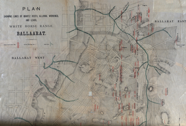
Plan, White Horse Range Ballarat, 1885, 06/1885
... Reefs include: Promised Land, Daniash, Sir Garnet Wolsley, Norwegian, Rothschile, Band and Albion, Finns, Llanberis, Roberts Lode, Tynworths and Black Hill, Oregan, Yorkshire, Try Again, Yorkshire, Post Office, Clarke's, Western Slates, Black Slate, Danks Slates, Eastern Slates, Queen's Lode, Fire Brigade. ...Reefs include: Promised Land, Daniash, Sir Garnet Wolsley, Norwegian, Rothschile, Band and Albion, Finns, Llanberis, Roberts Lode, Tynworths and Black Hill, Oregan, Yorkshire, Try Again, Yorkshire, Post Office, Clarke's, Western Slates, Black Slate, Danks Slates, Eastern Slates, Queen's Lode, Fire Brigade. ...Two plans .1) Plan of the Ballarat Goldfields showing leads, rivers, streets and topography. Quartz reefs include: Yorkshire, Try Again, Promised Land, Western Slates, Norwegian, Robert's Lode, Finn's, Band and albion, Rothschild, Old Post Office, Queen Lode. Leads include: Navy jacks, Gays, Canadian, Prince Regent, Sailors Gully, White Horse, Little White Horse, Milkmans, Nightingale, Golden Point, Gravel Pits. Scale is 8 Chains to 1 inch .2) Plan showing lines of quartz reefs, alluvial workings and leads, White Horse Range, Ballarat. Leads include White Horse LEad, Little White Horse Lead, One Eye Gully, Terrible Lead, Sailor's Gully, Canadian Lead, Prince Regent Gully, Canadian Lead, Cavs Lead, Navy jacks Lead, Eureka Lead, Old Gravel Pits Lead, Gravel Pits Lead, Nightingale Lead, Malakoff Lead, Milkmans Lead, Redan Lead, Woolshed Lead, Jacksons Lead, Winters Lead, SCtochman's Lead, Canadian Lead. Reefs include: Promised Land, Daniash, Sir Garnet Wolsley, Norwegian, Rothschile, Band and Albion, Finns, Llanberis, Roberts Lode, Tynworths and Black Hill, Oregan, Yorkshire, Try Again, Yorkshire, Post Office, Clarke's, Western Slates, Black Slate, Danks Slates, Eastern Slates, Queen's Lode, Fire Brigade. Mines include Red Streak, New Chum, Tinworths, Woah Hawp, Normanby, Speedwell, Llanberris Extended, Llanberis, Last Chance, Major, Countess, Pioneer and a number of batteries along Main Road Hills include: Mount Clear, Pennyweight Hill, Sovereign Hillballarat, plan, white horse range, white horse, goldfields, mines, reefs, indicators, leigh river, cgt, tinworth, mining -
 Wodonga & District Historical Society Inc
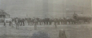
Photograph - North-Eastern Gold Days, 1900
... reef on New Year’s Day 1876. The 'Gift' mine site is located southeast of Kurrajong Gap lookout to the west of Bethanga township. The Great Eastern...reef on New Year’s Day 1876. The 'Gift' mine site is located southeast of Kurrajong Gap lookout to the west of Bethanga township. The Great Eastern ...Bethanga was established as a result of the discovery of gold. Gold was first reported in the Bethanga area in 1852. Before 1876 gold mining in the Bethanga district occurred to the north of the town and was known as the 'Talgarno diggings'. Reports of alluvial gold date back to 1852. Early gold fields were worked at Ruby Creek, Gold Creek and Jarvis Creek. The opening of the Bethanga goldfields began with the discovery of a gold-bearing quartz reef on New Year’s Day 1876. The 'Gift' mine site is located southeast of Kurrajong Gap lookout to the west of Bethanga township. The Great Eastern Copper Smelting Works was opened in 1878. Due to the nature of the gold-bearing quartz reef, the gold was difficult to extract, and the discovery of copper led to a change in focus. It was not until the early 1890s that an efficient technique for extracting the gold from the ore was discovered, and once again gold became the focus, with copper as a by-product. Bethanga was removed from the official list of goldfields in 1912, however some mining activity has taken place since.This image reflects an important time in the development of Bethanga and Northeast Victoria.A large mounted and framed image of horse teams and their owners hauling a large boiler to the gold mine near Bethanga, Victoria. On label beneath image: "North-eastern "Gold Days"/ Combined teams hauling a boiler to Bethanga Mines, 1900. Teamsters - Mr. G. Pearce, W. Chapple, G, Bannon." Donated by Ron Saunders and Barbara Cadman"bethanga, gold mining northeast victoria, gold mining bethanga, bethanga history -
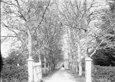 Stawell Historical Society Inc
Photograph, “The Sycamores” Driveway entrance Gates
... eastern side of the creek along which was planted pine and cypress trees. He built a comfortable house and line the carriage way with Sycamores. Osmand was on the of the men who made money in the Stawell reefs...eastern side of the creek along which was planted pine and cypress trees. He built a comfortable house and line the carriage way with Sycamores. Osmand was on the of the men who made money in the Stawell reefs ...Entrance gates to “The Sycamores” Driveway. A show place on Concongella from mid 1860's. "The Sychmores" where William Osmand lived. Osmand's "Sycamores" was in a secluded block of the eastern side of the creek along which was planted pine and cypress trees. He built a comfortable house and line the carriage way with Sycamores. Osmand was on the of the men who made money in the Stawell reefs mines. "The Sycamores" has been owned by the West family since c 1920. Black & white photograph (2 copies) of an entrance gateway with an avenue of deciduous trees.concongella -
 Bendigo Historical Society Inc.
Document - REMINISCENCES OF MR JACK HATTAM: ORAL HISTORY ASSIGNMENT
... Reef Company... Great Eastern Company...PERSON Individual Jack Hattam St Just Point Long Gully Voictorian Quarts Mining Company White Hills Cemetry Mr Henry Hattam Mayor of Bendigo Midway Company Victoria Reef Energetic ompany Bird's Reef Company Great Eastern Company (Sedgewick) Hercules Company Frank Cusack Bendigo Creek Bendigo Valley grub-staking Hopetoun Street John and Ellen O'Connell Hunters Brewery. ...Reminiscences of Mr Jack Hattam - 38 pp. Oral History assignment by Phyllis Smithson 1982. Introduction: ''This paper is a transcript of a taped interview with Mr Jack Hattam with annotations to augment his comments by Phyllis Smithson. Mr Hattam did not know a lot about his forebears so I have endeavoured to recreate some of the background and conditions his grandparents and relations would have encountered''. Bibliography and family tree.Jack Hattamperson, individual, jack hattam, st just point, long gully, voictorian quarts mining company, white hills cemetry, mr henry hattam mayor of bendigo, midway company, victoria reef, energetic ompany, bird's reef company, great eastern company, (sedgewick), hercules company, frank cusack, bendigo creek, bendigo valley, grub-staking, hopetoun street, john and ellen o'connell, hunters brewery. -
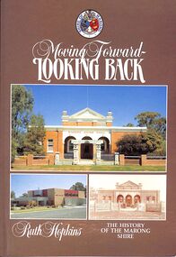 Bendigo Historical Society Inc.
Book - "Moving Forward - Looking Back", 1985
... eastern boundary enclosed Kangaroo Flat which after World War II had a population of about 1000 persons. By 1990 Kangaroo Flat had an estimated population of about 10,000, thus giving the shire a pronounced urban component. Accordingly, the shire was proclaimed a rural city on 1 October 1990. Marong shire had a mixture of agricultural districts, eucalypt forests and mining localities. There was gold mining at Maiden Gully, Wilson’s Reef...eastern boundary enclosed Kangaroo Flat which after World War II had a population of about 1000 persons. By 1990 Kangaroo Flat had an estimated population of about 10,000, thus giving the shire a pronounced urban component. Accordingly, the shire was proclaimed a rural city on 1 October 1990. Marong shire had a mixture of agricultural districts, eucalypt forests and mining localities. There was gold mining at Maiden Gully, Wilson’s Reef ...Marong Shire (1864-1994), immediately west and north of Bendigo, was proclaimed on 23 December 1864. Its western boundary was the Loddon River and its eastern boundary enclosed Kangaroo Flat which after World War II had a population of about 1000 persons. By 1990 Kangaroo Flat had an estimated population of about 10,000, thus giving the shire a pronounced urban component. Accordingly, the shire was proclaimed a rural city on 1 October 1990. Marong shire had a mixture of agricultural districts, eucalypt forests and mining localities. There was gold mining at Maiden Gully, Wilson’s Reef near Marong, Neilborough and Sebastian. The mining borough of Raywood was united with the shire on 1 October 1915. Lockwood was the shire’s administrative centre until 1908, when the centre was transferred to Marong. Marong municipality was served by two railway lines from Bendigo: north-westerly to Bridgwater-on-Loddon (1876) and northerly to Raywood and Pyramid Hill (1882). The Calder and Loddon Valley highways run generally north-west through the former municipality, through undulating to flat terrain, suitable for cereal growing and grazing. South of the Calder Highway the land is undulating to gullied. At the far south-west the Laanecoorie Reservoir lies on the Loddon River. In 1994 Marong rural city, with an area of 1489 sq km, had about 9000 cattle, 240,000 sheep and lambs and 11,000 pigs. About 6800 tonnes of barley and 27,000 tonnes of wheat were harvested. On 7 April 1994, Marong rural city was united with Bendigo city, Eaglehawk borough and Huntly and Strathfieldsaye shires to form Greater Bendigo city."Moving Forward - Looking Back" by Ruth Hopkins. Published for the Shire of Morong, Victoria 150th Anniversary Committee, by C G P Printing and Publishing, Bendigo. Printed in 1985. Soft cover book. Front cover is dark fawn brown in color with three photographs inset. Title and author's name in white on front cover and spine. Shire of Marong crest on front cover. Contains map of the then Marong Shire. Covers the history of Marong Shire. 119 pp. Contains both text and black and white images. ISBN 0949248037. shire, marong shire, kangaroo flat, marong