Showing 420 items matching "elevation"
-
 National Wool Museum
Blueprint, "Elevation of Four Cylinder Shearing Machine Shewing3 Cuts on Face and 1 Cut on Back"
... "Elevation of Four Cylinder Shearing Machine Shewing3 Cuts on Face and 1 Cut on Back"...Blueprint, printed white on blue paper, of the mechanical engineering drawings of "Elevation of Four Cylinder Shearing Machine Shewing3 Cuts on Face and 1 Cut on Back" -395C..."Elevation of Four Cylinder Shearing Machine Shewing3 Cuts on Face and 1 Cut on Back" -395C...."Elevation of Four Cylinder Shearing Machine Shewing3 Cuts on Face and 1 Cut on Back" Blueprint ...Blueprint, printed white on blue paper, of the mechanical engineering drawings of "Elevation of Four Cylinder Shearing Machine Shewing3 Cuts on Face and 1 Cut on Back" -395C"Elevation of Four Cylinder Shearing Machine Shewing3 Cuts on Face and 1 Cut on Back" -395C.ELEVATIOB OF FOUR CYLINDER SHEARING MACHINE SHEWING 3 CUTS ON FACE AND 1 CUT ON BACK -395Cshearing machinery shearing sheds shearing, shearing machinery, shearing sheds, shearing -
 National Wool Museum
Architectural Plan, Wool Warehouse, Moorabool St, Geelong for Messrs C.J. Dennys & Co., Plan Elevation in Moorabool Street
... Dennys & Co., Plan Elevation in Moorabool Street...Dennys & Co., Plan Elevation in Moorabool Street"....Dennys & Co., Plan Elevation in Moorabool Street...Dennys & Co., Plan Elevation in Moorabool Street Architectural Plan ...Original Jacob Pitman architectural plan of the Dennys Lascelles bluestone woolstore dated 1 March 1871. Titled "Wool Warehouse, Moorabool St, Geelong for Messrs C.J. Dennys & Co., Plan Elevation in Moorabool Street".Wool Warehouse, Moorabool St, Geelong for Messrs C.J. Dennys & Co., Plan Elevation in Moorabool Streetwool stores, pitman, mr jacob, dennys lascelles wool store -
 Bendigo Military Museum
Photograph - Johnson Ground Elevation Meter (JGEM) Survey Vehicle - Army Survey Regiment, Fortuna, Bendigo, c1960s
... Johnson Ground Elevation Meter (JGEM) Survey Vehicle - Army Survey Regiment, Fortuna, Bendigo....This is a set of 16 photograph of the Royal Australian Survey Corps’ Johnson Ground Elevation Meter (JGEM) Survey Vehicle taken at the Army Survey Regiment, Fortuna, Bendigo. ...This is a set of 16 photograph of the Royal Australian Survey Corps’ Johnson Ground Elevation Meter (JGEM) Survey Vehicle taken at the Army Survey Regiment, Fortuna, Bendigo. ...Bendigo Military Museum 37 - 39 Pall Mall Bendigo goldfields This is a set of 16 photograph of the Royal Australian Survey Corps’ Johnson Ground Elevation Meter (JGEM) Survey Vehicle taken at the Army Survey Regiment, Fortuna, Bendigo. ...This is a set of 16 photograph of the Royal Australian Survey Corps’ Johnson Ground Elevation Meter (JGEM) Survey Vehicle taken at the Army Survey Regiment, Fortuna, Bendigo. The JGEM vehicle was extensively used by RA Svy within Australia from the late 1960s. A limited number of Ground Elevation Meter (GEM) station wagon type vehicles were manufactured by General Motors Corporation (GMC) in the USA for the United States Geological Survey, Canada’s mapping agencies, RA Svy and National Mapping (Natmap). The GEM was a four-wheel drive, four-wheel steer vehicle. Four-wheel steering was necessary to avoid systematic errors caused by non-tracking of front and rear wheels on conventionally steered vehicles. The manufacturer substituted the rear axle with a front axle and connected them to form the four-wheel steering mechanism. The two Australian GEM vehicles, referred to as Johnson GEMs (JGEMs) were converted into right-hand drive. After delivery in 1964, acceptance Natmap and RA Svy testing and operator training was undertaken at the Army's School of Military Survey located at Balcombe, Victoria. A small fifth wheel was mounted on a cantilever arm suspension midway between the front and rear wheels on the right side of the vehicle. It was lowered to and raised from its operating position by use of a constant pressure air cylinder. A telescopic bar, suspended between the front and rear axles, provided the reference datum for the angle measurement. The wheel provided the velocity or distance signal through a pulse generator system. A sensitive pendulum mounted on this bar provided the angle measurement for each minute distance traversed. The JGEM contained electromechanical instruments used to determine relative elevations, by trigonometric principles, along a traversed path. These relative elevations were obtained through apparatus which measures the instantaneous angle of inclination of the road and the instantaneous velocity of the meter along such a path. Road routes over which the JGEM operated were planned so that each started and ended as near as practicable to an existing point of known elevation (formally referred to as a level traverse bench mark). The difference in height from the bench mark and the road surface alongside the JGEM’s fifth wheel was measured with a level and staff. Along each route, mapping control photo reference points where new elevation values were required were identified on aerial photographs. Under favourable conditions it was possible to survey as much as 160km in an ordinary working day. The first of RA Svy’s JGEM operations was undertaken in 1:250,000 scale map areas of Queensland. CPL John Hook was the JGEM’s main operator in the early 1970s undertaking operations covering 1:250,000 scale map blocks over northern Victoria and central NSW, each requiring 36 points (9 runs of photography and 4 points across. SPR Lyn Thompson and SPR Bob McDonagh teamed with CPL Hook on some of these JGEM operations. When RA Svy was integrated into the Royal Australian Engineers in 1996, the JGEM vehicle with the Survey Corps collection was donated to its museum. It is believed to be the last of the original manufactured fleet in existence. The JGEM has undergone extensive refurbishment to achieve roadworthiness and is currently housed at The Australian Army Museum of Military Engineering, Hoslworthy Barracks, NSW. It can be viewed by making an appointment with the museum’s curator.This is a set of 16 photograph of the Royal Australian Survey Corps’ Johnson Ground Elevation Meter (JGEM) Survey Vehicle taken at the Army Survey Regiment, Fortuna, Bendigo. The photographs were on 35mm slide film and were scanned at 96 dpi. They are part of the Army Survey Regiment’s Collection. .1) - Photo, colour, c1960s, Johnson Ground Elevation Meter (JGEM) Survey Vehicle .2) - Photo, colour, c1960s, JGEM instrumentation, on-board computer. .3) - Photo, colour, c1960s, JGEM instrumentation. .4) - Photo, colour, c1960s, JGEM instrumentation, on-board computer. .5) - Photo, colour, c1960s, JGEM tyre pressure controller .6) - Photo, colour, c1960s, JGEM rear doors, SGT Geoff Briggs. .7) - Photo, colour, c1960s, JGEM 5th wheel distance/angle measurement device in lowered position, SGT Geoff Briggs. .8) - Photo, colour, c1960s, JGEM 5th wheel distance/angle measurement device in lowered position. .9) & .10) - Photo, colour, c1960s, JGEM tyre pressure system, SGT Geoff Briggs. .11) - Photo, colour, c1960s, JGEM tyre pressure system. SGT Geoff Briggs. .12) - Photo, colour, c1960s, JGEM levelling scope, levelling staff, unidentified technicians. .13) & .14) - Photo, colour, c1960s, JGEM levelling scope, unidentified technician. .15) & .16) - Photo, colour, c1960s, probably survey operation adjusted height plotted on block base sheet. .1P to .16P - Some of the equipment is annotated on the frame of the 35mm slides.royal australian survey corps, rasvy, army survey regiment, army svy regt, fortuna, asr, surveying -
 Federation University Historical Collection
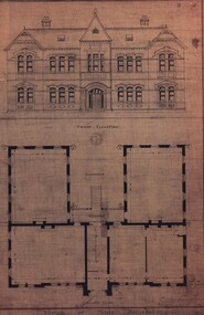
Plan - Architectural Plan, Architectural Plan for the Back and Flank Elevation of the Ballarat School of Mines New Classrooms, 1899
... Architectural Plan for the Back and Flank Elevation of the Ballarat School of Mines New Classrooms...Framed original plan of the back and flank elevation of Ballarat School of Mines New Classrooms (later called the Administration Building). ...Architectural Plan for the Back and Flank Elevation of the Ballarat School of Mines New Classrooms Plan Architectural Plan ...Framed original plan of the back and flank elevation of Ballarat School of Mines New Classrooms (later called the Administration Building). ballarat school of mines, architectural plan, administration building, new classrooms -
 Federation University Historical Collection
Plan - Postcard, Front Elevation of the Ballarat School of Mines New Classrooms (now Administration Building), 1898, 16/02/1899
... Front Elevation of the Ballarat School of Mines New Classrooms (now Administration Building), 1898...The plan shows the front elevation, section on line, ground and 1st floor plan. ...The plan shows the front elevation, section on line, ground and 1st floor plan. ...In 1900 this building was described as 'handsome in design, well lit, well ventilated, commodious - containing Council room, office, chemical laboratory, mineralogical laboratory, students room and six lecture rooms. Postcard of the original hand coloured plan on linen of the Ballarat School of Mines New Classrooms (from 2014 known as the Federation University Australia SMB campus Administration Building). The plan shows the front elevation, section on line, ground and 1st floor plan. ballarat school of mines, new classrooms, administration building, architectural plans -
 Uniting Church Archives - Synod of Victoria
Document - Form, Methodist Order of Knights: Petition for elevation to Christian Knighthood
... Methodist Order of Knights: Petition for elevation to Christian Knighthood...Methodist Church of Australasia Methodist Order of Knights: Petition for Elevation to Christian Knighthood forms. The forms are addressed to the Bishop of the Court who after he had endorsed and recommended the candidate forwarded it on the the Grand Chief Knight for final approval. ...Methodist Order of Knights: Petition for elevation to Christian Knighthood Document Form ...The Methodist Order of Knights was the official youth organisation of the Methodist Church of Australasia. It originated in Hurstville, NSW, on the 4th October 1914 by the then Mr and later Rev Alex Bray. Alex Bray was a Sunday School teacher and spoke to his class of the Knights of the Round Table. In 1917 the Order of Knights was officially recognised by the Sunday School Dept of the NSW Methodist Conference. Courts spread thoroughout Australia. In 1927 the High Court of NSW called for designs for a badge and in 1929 the General Conference of the Methodist Church of Australasia recognised the Order as an approved Organisation. In 1938 the Senior Section was organised into Degrees of Sincerity, Service and Sacrifice; the Junior Section into Pages' Degree with advancement to Esquire. In 1954 the Junior Section was reorganised into two groups: Pages 8 to 11 years and Esquires 12 to 15 years. The Knight's Motto: "Live Pure, Speak True, Right Wrong, Follow Christ the King, else wherefore born?" Courts of the Order: General Conference Department of the Christian Education - General Court - Provincial High Court - District Court - Local Court - Senior Court - Intermediate Court - Junior Court . Regalia: All members of the Intermediate and Senior Courts wore regalia consisting of a cloth shield superimposed by a cross of light and dark blue ribbons, and supported by a cloth collar. Esquire and Degree of Sincerity regalia: White collar and white shield. Degree of Service regalia: Green collar and shield. Degree of Sacrifice: Scarlet collar and shield. District Court regalia: Blue collar and gold shield. High Court regalia: Gold collar and purple sheild. General Court regalia: Purple collar and shield. Officers of the local courts wore their symbols as part of their regalia.Blank forms in two sizes: E3112.33.1 (three forms) and E3112.2 (two forms). Methodist Church of Australasia Methodist Order of Knights: Petition for Elevation to Christian Knighthood forms. The forms are addressed to the Bishop of the Court who after he had endorsed and recommended the candidate forwarded it on the the Grand Chief Knight for final approval. methodist order of knights -
 Ballarat Tramway Museum
Document - Photocopy, Alan Bradley, "Plan and Front Elevation of Car Depot", 2000
... "Plan and Front Elevation of Car Depot"...Drawn at a scale of 1/16" = 1', shows building layout, track layout, overall dimensions, a proposed extension to hold eleven trailers, a front elevation showing pits, extension (drawn at 1/8" = 1'). ..."Plan and Front Elevation of Car Depot" Document Photocopy Alan Bradley ...Set of three A3 size photocopies of a drawing held by the Public Records Office Victoria of the Ballarat ESCo Tramway Depot, dated 2/8/1912. Drawn at a scale of 1/16" = 1', shows building layout, track layout, overall dimensions, a proposed extension to hold eleven trailers, a front elevation showing pits, extension (drawn at 1/8" = 1'). On the current tracks, shows the individual track capacities - 26 trams. Drawings copied by Alan Bradley for archives and research.trams, tramways, ballarat, esco, depot, drawings -
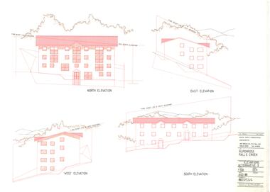
 Falls Creek Historical Society
Plan - Alpenrose Redevelopment - Alternative 1 Elevations, 1988
... A coloured plan showing the side elevation views of the Alpenrose Ski Lodge. ...Alpenrose Falls Creek Alternative 1 Elevations Prepared by David C Hoff and Associates - Architects...Alpenrose Redevelopment - Alternative 1 Elevations Plan Alpenrose Redevelopment - Alternative 1 Elevations ...Charles (Bill) Bridgford built a family lodge at Falls Creek called St. Trinian's in the early 1950s. Bill had previously worked in the family shipping firm and had been Member for South Eastern in the Victorian Parliament. He became one of the shareholders in the Village rope tow which had been a failure partly because too many people had been involved. In 1960 Bridgford approached Toni St. Elmo with an offer to buy the Nissen tow and Nissen Lodge which was accepted. With friends Geoff Henke and Ron McCallum, an engineer, he formed Alpine Developments (Holdings) Pty. Ltd. Ron had also been Lift Manager at Mt. Buller and together they acquired the Village rope tow and replaced it with a T-bar. They gained the franchise to operate all ski lifts and T-bars and later the Falls Creek Ski School. Alpine Developments (Holdings) Pty. Ltd continued to expand the lift network until 1983 when the lifts were sold to Transfield. In 1964 Bridgford, along with Geoff Henke and L G Morrison acquired a license to construct a restaurant which became known as the Frying Pan. About this time he also built the Alpenrose located next to the Wagga Ski Club Lodge in Sitzmark Street, Falls Creek. These plans illustrate the proposed redevelopment of the Alpenrose in 1988.These plans represent a business development by a significant member of the Falls Creek community.A coloured plan showing the side elevation views of the Alpenrose Ski Lodge. Alpenrose Falls Creek Alternative 1 Elevations Prepared by David C Hoff and Associates - Architectsfalls creek businesses, bill bridgford, alpenrose falls creek -
 Falls Creek Historical Society
Plan - Alpenrose Redevelopment - Alternative 3 Elevations, 1988
... A coloured plan showing the side elevation views of the Alpenrose Ski Lodge. ...Alpenrose Falls Creek Alternative 3 Elevations Prepared by David C Hoff and Associates - Architects...Alpenrose Redevelopment - Alternative 3 Elevations Plan Alpenrose Redevelopment - Alternative 3 Elevations ...Charles (Bill) Bridgford built a family lodge at Falls Creek called St. Trinian's in the early 1950s. Bill had previously worked in the family shipping firm and had been Member for South Eastern in the Victorian Parliament. He became one of the shareholders in the Village rope tow which had been a failure partly because too many people had been involved. In 1960 Bridgford approached Toni St. Elmo with an offer to buy the Nissen tow and Nissen Lodge which was accepted. With friends Geoff Henke and Ron McCallum, an engineer, he formed Alpine Developments (Holdings) Pty. Ltd. Ron had also been Lift Manager at Mt. Buller and together they acquired the Village rope tow and replaced it with a T-bar. They gained the franchise to operate all ski lifts and T-bars and later the Falls Creek Ski School. Alpine Developments (Holdings) Pty. Ltd continued to expand the lift network until 1983 when the lifts were sold to Transfield. In 1964 Bridgford, along with Geoff Henke and L G Morrison acquired a license to construct a restaurant which became known as the Frying Pan. About this time he also built the Alpenrose located next to the Wagga Ski Club Lodge in Sitzmark Street, Falls Creek. These plans illustrate the proposed redevelopment of the Alpenrose in 1988.These plans represent a business development by a significant member of the Falls Creek community.A coloured plan showing the side elevation views of the Alpenrose Ski Lodge. Alpenrose Falls Creek Alternative 3 Elevations Prepared by David C Hoff and Associates - Architectsfalls creek businesses, bill bridgford, alpenrose falls creek -
 Federation University Historical Collection
Plan, School of Mines, Ballarat: Front elevation plan for new building, 1899, 1899
... School of Mines, Ballarat: Front elevation plan for new building, 1899...Barker Library (top floor) Mount Helen goldfields ballarat school of mines plan front elevation new classrooms administration building a building architectural drawing Mounted photocopy of plans for 1899 School of Mines, Ballarat: Front elevation plan for new building, 1899 Plan ...Mounted photocopy of plans for 1899ballarat school of mines, plan, front elevation, new classrooms, administration building, a building, architectural drawing -
Federation University Historical Collection
Plan - Architectural Plan, Architectural Plan for the Front Elevation of the Ballarat School of Mines New Classrooms, 1899
... Architectural Plan for the Front Elevation of the Ballarat School of Mines New Classrooms...Architectural Plan for the Front Elevation of the Ballarat School of Mines New Classrooms Plan Architectural Plan ...Framed original plan of the fron televation of Ballarat School of Mines New Classrooms (later called the Administration Building). ballarat school of mines, architectural plan, administration building, new classrooms -
 Eltham District Historical Society Inc
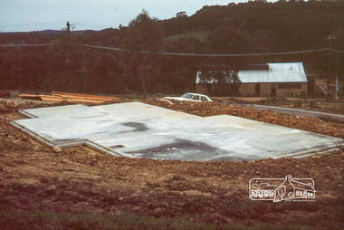
Photograph, Concrete slab from north elevation
... Concrete slab from north elevation...It was one of the earliest estates in Eltham following the nearby Woodridge Estate development. stokes place eltham stokes orchard stokes orchard estate streets houses peter and carla vermey Scanned by EDHS from 49 x 35mm colour transparencies provided on loan Digital file Concrete slab from north elevation Photograph ...14 Stokes Place (Lot 83) was the home of Peter and Carla Vermey. The land was purchased in May 1979 and construction commenced September 1979. The home was built by Peter and Carla Vermey after the developer, Macquarie Builders went bankrupt. Sold October 2017 by Morrison and Kleeman Real Estate. Stokes Place was part of the Stokes Orchard Estate which was developed from the break-up of the the orchard owned by Frank Stokes who lived on the northeast corner of Nyora Road and Eucalyptus Road. His daughter Beryl advised that the Shire had levied a rate assessment on individual parcels of land within the orchard which became unaffordable resulting in its sub-division and sell off. The Stokes Orchard Estate was developed by Macquarie Builders in two stages starting with stage 1 in 1976. Stokes Place was part of Stage 2 in 1979. The Estate was bounded between Nyora Road, Eucalyptus Road, Diosma Road and Stokes Place. The original orchard only just reached the left most portions of Stokes Place and did not go fully up to Diosma, rather to just beyond the extant of Stokes Place. Stokes Place was known within the family as "The Oats" as that is where they grew oats. Frank Stokes moved to Eltham c.1945 after visiting Harold Bird to view his orchard, located diagonally opposite Stokes Orchard from the intersection of Eucalyptus Road, Pitt Street and Nyora Road. It was on Harold Bird's recommendation that Frank purchased the land.The Stokes Orchard Estate collection is typical of housing developments of the late 1970s and 1980s. It was one of the earliest estates in Eltham following the nearby Woodridge Estate development.Digital fileScanned by EDHS from 49 x 35mm colour transparencies provided on loanstokes place, eltham, stokes orchard, stokes orchard estate, streets, houses, peter and carla vermey -
 Eltham District Historical Society Inc
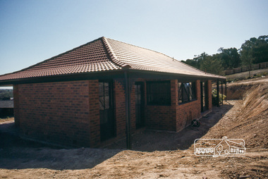
Photograph, House, south elevation and back excavation, April 1980
... House, south elevation and back excavation, April 1980...It was one of the earliest estates in Eltham following the nearby Woodridge Estate development. stokes place eltham stokes orchard stokes orchard estate streets houses peter and carla vermey Scanned by EDHS from 49 x 35mm colour transparencies provided on loan Digital file House, south elevation and back excavation, April 1980 Photograph ...14 Stokes Place (Lot 83) was the home of Peter and Carla Vermey. The land was purchased in May 1979 and construction commenced September 1979. The home was built by Peter and Carla Vermey after the developer, Macquarie Builders went bankrupt. Sold October 2017 by Morrison and Kleeman Real Estate. Stokes Place was part of the Stokes Orchard Estate which was developed from the break-up of the the orchard owned by Frank Stokes who lived on the northeast corner of Nyora Road and Eucalyptus Road. His daughter Beryl advised that the Shire had levied a rate assessment on individual parcels of land within the orchard which became unaffordable resulting in its sub-division and sell off. The Stokes Orchard Estate was developed by Macquarie Builders in two stages starting with stage 1 in 1976. Stokes Place was part of Stage 2 in 1979. The Estate was bounded between Nyora Road, Eucalyptus Road, Diosma Road and Stokes Place. The original orchard only just reached the left most portions of Stokes Place and did not go fully up to Diosma, rather to just beyond the extant of Stokes Place. Stokes Place was known within the family as "The Oats" as that is where they grew oats. Frank Stokes moved to Eltham c.1945 after visiting Harold Bird to view his orchard, located diagonally opposite Stokes Orchard from the intersection of Eucalyptus Road, Pitt Street and Nyora Road. It was on Harold Bird's recommendation that Frank purchased the land.The Stokes Orchard Estate collection is typical of housing developments of the late 1970s and 1980s. It was one of the earliest estates in Eltham following the nearby Woodridge Estate development.Digital fileScanned by EDHS from 49 x 35mm colour transparencies provided on loanstokes place, eltham, stokes orchard, stokes orchard estate, streets, houses, peter and carla vermey -
 Port Melbourne Historical & Preservation Society
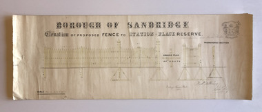
Plan, Charles Clay, Borough Surveyor, Elevation of Proposed Fence to Station Place Reserve, c. 1881
... Elevation of Proposed Fence to Station Place Reserve...Undated Borough of Sandridge hand-drawn plan for a proposed picket fence at Station Place Reserve. Elevation of Proposed Fence to Station Place Reserve Plan Charles Clay, Borough Surveyor ...Although undated, the plan is probably from 1880-81. The plan is signed by Charles CLAY, Fred WILLIAMS and Witney Henry BATES. Charles CLAY was the Borough Surveyor from 1860 to 1884. Fred WILLIAMS was a Councillor 1875 to 1886 and served as Mayor, 1880-81. It is not known who Witney Henry BATES was. A note in pencil, probably added later, indicates the fence was between Graham and Bridge Streets.Undated Borough of Sandridge hand-drawn plan for a proposed picket fence at Station Place Reserve.'between Graham and Bridge Streets' handwritten in pencil below and to the right of the main title.local government - borough of sandridge, engineering - fences, charles clay, witney henry bates, frederick williams -
 Ringwood and District Historical Society
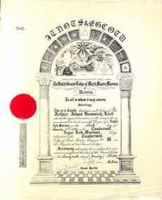
Certificate, Elevation Certificate, United Grand Lodge of Mark Master Masons - Collection of Masonic Degrees and Correspondence maintained by Aird family of Ringwood, Victoria
... Elevation Certificate, United Grand Lodge of Mark Master Masons - Collection of Masonic Degrees and Correspondence maintained by Aird family of Ringwood, Victoria...Signed and dated 26th January, 1944. Elevation Certificate, United Grand Lodge of Mark Master Masons - Collection of Masonic Degrees and Correspondence maintained by Aird family of Ringwood, Victoria Certificate ...Buff coloured certificate with red Lodge seal. Certification that Bro. Arthur James Bromwich Aird was elevated to the honorable Degree of a Royal Ark Mariner on 9th November 1943 in the Camberwell Royal Ark Mariner Lodge attached to the Camberwell Lodge of Mark Master Masons No. 86. Signed and dated 26th January, 1944. -
 Ringwood and District Historical Society
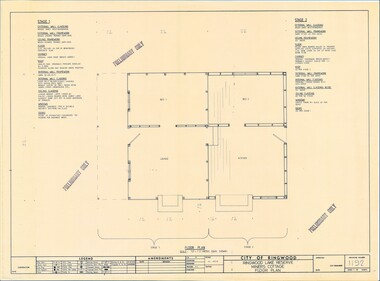
Plan - Ringwood Lake Reserve Miners Cottage - 1983, Preliminary Building Plans - 3 Sheets. Floor Plan, Elevation, Sectional Views and Details
... Preliminary Building Plans - 3 Sheets. Floor Plan, Elevation, Sectional Views and Details ...Preliminary Building Plans - 3 Sheets. Floor Plan, Elevation, Sectional Views and Details Plan Ringwood Lake Reserve Miners Cottage - 1983 ...Sheets 1, 2 & 3 - Construction of replica miners cottage at Ringwood Lake Reserve, opened May, 1983.Preliminary Only -
 Federation University Historical Collection
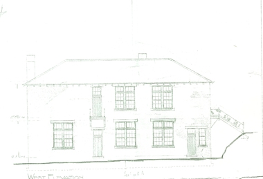
Plan, West Elevation of the Ballarat School of Mines Building Old Plumbing Building
... West Elevation of the Ballarat School of Mines Building Old Plumbing Building ...(Research by David Rowe) ballarat school of mines plans building o plumbing old plumbing building h.j. kerr s.c. brittingham Copy of the Plumbing building on the grounds of the Ballarat School of Mines campus West Elevation of the Ballarat School of Mines Building Old Plumbing Building Plan ...This building was built in 1918-19 to a design by H.J. Kerr, District Architect (Western District), under the design control of the Chief Architect, S.C. Brittingham, Public Works Department. Their initials appear on the attached copy of the original drawing of the building. (Research by David Rowe)Copy of the Plumbing building on the grounds of the Ballarat School of Mines campusballarat school of mines, plans, building o, plumbing, old plumbing building, h.j. kerr, s.c. brittingham -
 Federation University Historical Collection
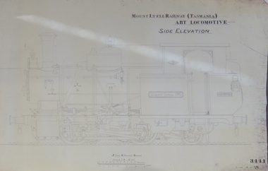
Plan, Mount Lyell Railway (Tasmania) ABT Locomotive Side Elevation, undated
... Mount Lyell Railway (Tasmania) ABT Locomotive Side Elevation...Mount Lyell Railway (Tasmania) ABT Locomotive Side Elevation Plan Plan ...On 29 March 1893 the Mount Lyell Mining and Railway Company was formed. This Tasmanian mining company was often referred to as Mount Lyell. Mount Lyell, and was the dominant copper mining company of the Tasmanian West Coast from 1893 to 1994, and was based in Queenstown, Tasmania. After consolidation of leases and company assets at the beginning of the twentieth century, Mount Lyell was the major company for the communities of Queenstown, Strahan and Gormanston. It closed in 1994. The Mount Lyell mining operations produced more than a million tonnes of copper, 750 tonnes of silver and 45 tonnes of gold since mining commenced in the early 1890s – which is equivalent to over 4 billion dollars worth of metal in 1995 terms.Copy of a plan of a locomotive.mount lyell, locomotive, mount lyell railway, quuenstown, tasmania, strahan, gormamston, railway -
 Beechworth Honey Archive
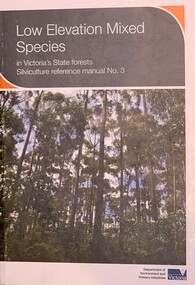
Publication, Low Elevation Mixed Species in Victoria's State forests Silviculture reference manual No. 3 (Dept of Environment and Primary Industries)Simon Murphy, Ron Hateley and Peter Fagg, 2013
... Low Elevation Mixed Species in Victoria's State forests Silviculture reference manual No. 3 (Dept of Environment and Primary Industries)Simon Murphy, Ron Hateley and Peter Fagg...Beechworth Honey Archive 87 Ford Street Beechworth high-country Soft cover book, slightly larger than A5 size, white & grey cover with a photo of a forest 158 pages Low Elevation Mixed Species in Victoria's State forests Silviculture reference manual No. 3 (Dept of Environment and Primary Industries)Simon Murphy, Ron Hateley and Peter Fagg Publication ...Soft cover book, slightly larger than A5 size, white & grey cover with a photo of a forest 158 pages -
 Bayside Gallery - Bayside City Council Art & Heritage Collection
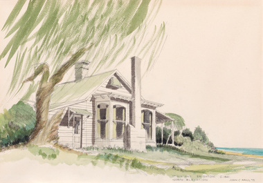
Work on paper - watercolour, John C. Paul, St. Ninian's north elevation c.1841, 1971
... St. Ninian's north elevation c.1841...The property was demolished in 1974. st ninian's brighton historic house george ward cole thomas bent St. Ninian's north elevation c.1841 Work on paper watercolour John C. ...Built around 1841, St Ninian’s, located at 10 Miller Street, was one of Brighton’s earliest buildings. It is best known as being the home of merchant shipping agent, politician and former British naval officer, George Ward Cole between the 1840s and 1902. Following the death of George Ward Cole in 1879 and his wife in 1898, their only surviving child, Margaret, sold the property to Sir Thomas Bent, who subdivided the land in the early 1900s. The property was demolished in 1974. John C. Paul, St. Ninian's north elevation c.1841 1971, watercolour, 29.5 x 42.3 cm. Bayside City Council Art and Heritage Collection. Purchased 1974.st ninian's, brighton, historic house, george ward cole, thomas bent -
 Bayside Gallery - Bayside City Council Art & Heritage Collection
Work on paper - watercolour, John C. Paul, St. Ninian's south elevation c.1841, 1971
... St. Ninian's south elevation c.1841...The property was demolished in 1974. st ninian's brighton historic house george ward cole thomas bent St. Ninian's south elevation c.1841 Work on paper watercolour John C. ...Built around 1841, St Ninian’s, located at 10 Miller Street, was one of Brighton’s earliest buildings. It is best known as being the home of merchant shipping agent, politician and former British naval officer, George Ward Cole between the 1840s and 1902. Following the death of George Ward Cole in 1879 and his wife in 1898, their only surviving child, Margaret, sold the property to Sir Thomas Bent, who subdivided the land in the early 1900s. The property was demolished in 1974. John C. Paul, St. Ninian's south elevation c.1841 1971, watercolour, 29.5 x 43 cm. Bayside City Council Art and Heritage Collection. Purchased 1974.st ninian's, brighton, historic house, george ward cole, thomas bent -
 Department of Health and Human Services
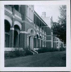
Photograph, The front facade, built in 1899, showing the existing elevation, of the Queen Victoria Ward, originally 'the women's ward', Ballarat Hospital in September 1957 - Regional & District Hospital Collection - Department of Health & Human Services (DHHS)
... The front facade, built in 1899, showing the existing elevation, of the Queen Victoria Ward, originally 'the women's ward', Ballarat Hospital in September 1957 - Regional & District Hospital Collection - Department of Health & Human Services (DHHS)...Department of Health and Human Services 50 Lonsdale St Melbourne melbourne Photo taken by the Department of Health - Building & Services Division - Facilities Development - Ballarat Hospital - September 1957 The front facade, built in 1899, showing the existing elevation, of the Queen Victoria Ward, originally 'the women's ward', Ballarat Hospital in September 1957 - Regional & District Hospital Collection - Department of Health & Human Services (DHHS) Photograph ...Photo taken by the Department of Health - Building & Services Division - Facilities Development - Ballarat Hospital - September 1957 -
University of Melbourne, Burnley Campus Archives
Plan, Concept Plan, Cross-Section Elevation, c. 1990
... Concept Plan, Cross-Section Elevation...Concept Plan, Cross-Section Elevation Plan ...Plans for 2 different gardens by Amanda McLaurin (student). Scale 1:50.amanda mclaurin, concept plans, home garden design -
 Friends of Ballarat Botanical Gardens History Group
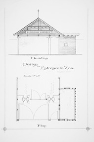
Plan - Elevation Design for Entrance to Zoo
... Elevation Design for Entrance to Zoo...Friends of Ballarat Botanical Gardens History Group George Longley Building Gillies Street North entrance Ballarat West 3350 Historical Ballaarat Botanical Gardens Zoo Entrance design Plan photocopy Elevation Design for Entrance to Zoo Plan Elevation Design for Entrance to Zoo ...Historical photocopyballaarat botanical gardens, zoo, entrance design, plan -
Moorabbin Air Museum
Drawing (item) - Bristol Beaufort Front-on Technical Drawing, Front Elevation of Beaufort Torpedo Bomber
... Front Elevation of Beaufort Torpedo Bomber...Moorabbin Air Museum Moorabbin Airport 12 First Street Moorabbin melbourne Large technical drawings on paper Front Elevation of Beaufort Torpedo Bomber Drawing Bristol Beaufort Front-on Technical Drawing ... -
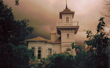 Kew Historical Society Inc
Photograph - 'Swinton', 23 Swinton Avenue, 2000
... Original colour positive photograph of the west elevation of Swinton, 23 Swinton Avenue, Kew. ...Ink on reverse: "Swinton - west elevation / Feb 2000"...Ink on reverse: "Swinton - west elevation / Feb 2000" Original colour positive photograph of the west elevation of Swinton, 23 Swinton Avenue, Kew. ...Swinton is of significance as one of the earliest examples of the use of the Italianate in Australian domestic architecture, and for the elegance of its design, particularly in the tower.Original colour positive photograph of the west elevation of Swinton, 23 Swinton Avenue, Kew. Facade facing Yarra River featuring tower and balcony with door and fanlight below. Projecting bay window at left. Rendered brick with slate roof. Ink on reverse: "Swinton - west elevation / Feb 2000"swinton, swinton avenue -- kew (vic.) -
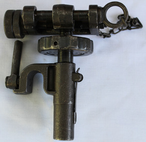 Dandenong/Cranbourne RSL Sub Branch
Equipment - Training & Elevation Device, Circa 1941
... Traverse and Elevation Mechanism T&E for the U.S. Browning M1919A4 .30 cal M2 Tripod...B166489-4, conjoined AD, CSW, A139987, B.195549 2.A, and has graduated markings on two knurled training and elevation nuts....Dandenong/Cranbourne RSL Sub Branch 44 – 50 Clow Street Dandenong melbourne Military B166489-4, conjoined AD, CSW, A139987, B.195549 2.A, and has graduated markings on two knurled training and elevation nuts. Traverse and Elevation Mechanism T&E for the U.S. ...Traverse and Elevation Mechanism T&E for the U.S. Browning M1919A4 .30 cal M2 TripodB166489-4, conjoined AD, CSW, A139987, B.195549 2.A, and has graduated markings on two knurled training and elevation nuts.military -
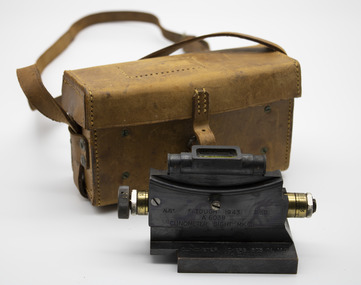 Rutherglen RSL Sub-Branch
Functional object - Clinometer sight in leather carrying case
... Clinometer sight has black metal and brass elevation scale, spirit level on top of sight with base...M.G/MKII REVERSE SIDE : ELEVATION SCAALE NUMBER 20D-5D. 0-20E BASE : TARGET...M.G/MKII REVERSE SIDE : ELEVATION SCAALE NUMBER 20D-5D. 0-20E BASE : TARGET Clinometer sight has black metal and brass elevation scale, spirit level on top of sight with base Functional object Clinometer sight in leather carrying case ...Clinometer sight has black metal and brass elevation scale, spirit level on top of sight with baseAUST. F. TOUGH 1943 D^D/A.6038/CLINCOMETER. SIGHT MK (ii)/CLINOMETER VICKERS .303 IN. M.G/MKII REVERSE SIDE : ELEVATION SCAALE NUMBER 20D-5D. 0-20E BASE : TARGET -
 Kew Historical Society Inc
Slide - Architectural Drawing, Kew Public Offices, 1887
... FRONT ELEVATION...They are historically and architecturally significant to the State Of Victoria because Watson and Harvey's designs exhibit diversity in integrating civil offices, they accommodate the apex of road junctions, and they demonstrate a departure from the contemporaneously favoured High Victorian Classical to the Queen Anne style in the design of civic buildings. kew court house kew police station kew post office architectural drawings khs - slides new public offices — kew (vic.) architecture — queen anne style FRONT ELEVATION 35mm colour transparency of an original plan by George Watson and John Henry Harvey, architects of the Department of Public Works (Victoria), in 1887 for New Public Offices at Kew. ...A civic campaign for new public offices developed in Kew in the 1880s. After much deliberation, the location chosen was the junction of Bulleen and Cotham Roads. The buildings were designed by George Watson and John Henry Harvey, architects within the Department of Public Works (Victoria). Building was commenced in 1887, and after one year, the buildings were opened. The Post Office was transferred to the new Commonwealth Government in 1901. The Police Station and Court House, sold by the Victorian Government to the City of Boroondara in 2007, are now a community cultural centre and performing arts venue.The buildings were listed on the Victorian Heritage Register Register (HO885) in 1991. They are historically and architecturally significant to the State Of Victoria because Watson and Harvey's designs exhibit diversity in integrating civil offices, they accommodate the apex of road junctions, and they demonstrate a departure from the contemporaneously favoured High Victorian Classical to the Queen Anne style in the design of civic buildings. 35mm colour transparency of an original plan by George Watson and John Henry Harvey, architects of the Department of Public Works (Victoria), in 1887 for New Public Offices at Kew. This plan was copied by the donor from an original held at the Commonwealth Archives in Brighton (Vic). The copy was made to illustrate a report that the donor made on ‘The functional planning design, building materials and construction methods of the Kew Post Office’ as part of course work at RMIT.FRONT ELEVATIONkew court house, kew police station, kew post office, architectural drawings, khs - slides, new public offices — kew (vic.), architecture — queen anne style -
 Federation University Art Collection
Architectural Drawing, Measured drawing ornament House Fitzroy Gardens by Albert E. Williams, c1920, c1920
... Pen and ink measured drawing showing side elevation, front elevation, sectional elevation and scales....The Art Collection features over 1000 works and was listed as a 'Ballarat Treasure' in 2007. art artwork williams albert e. williams ballarat technical art school architecture art teachers' certificate Pen and ink measured drawing showing side elevation, front elevation, sectional elevation and scales. ...Albert E. Williams first studied art under Fred Foster after being awarded a scholarship to the Ballarat East Art School. In 1913 he became one of the first intake of 83 students to study the Merit Certificate at the newly opened Ballarat Junior Technical School. Williams was the second person to receive a certificate from that institution. He then studied under H.H. Smith for the Art Teachers’ Certificate at the Ballarat School of Mines Technical Art School between 1915 and 1920. Williams joined the staff of the Ballarat Junior Technical School in 1921, teaching sign writing, ticket writing and house decoration. He taught in other technical schools between 1923 and 1928, returning to Ballarat in that year to fill a vacancy left by John Rowell . Williams continued his teaching career at both the Ballarat School of Mines Technical Art School and the Junior Technical School until 1942. He taught in various other technical schools from 1943, retiring as Headmaster of the Brighton Technical School in 1964. Albert E. Williams continued producing artwork throughout his career, and was responsible for the education of generations of artists and art teachers. This item is part of the Federation University Art Collection. The Art Collection features over 1000 works and was listed as a 'Ballarat Treasure' in 2007.Pen and ink measured drawing showing side elevation, front elevation, sectional elevation and scales.art, artwork, williams, albert e. williams, ballarat technical art school, architecture, art teachers' certificate