Showing 40 items matching "fairfield bridge"
-
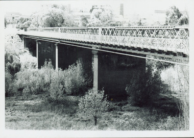
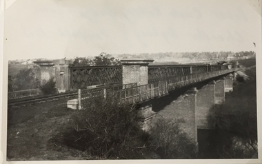
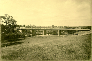
![The Fairfield Bridge [circa 1891]](/media/collectors/550653872162f11fb04854aa/items/579eab98d0cdd117c4af1c89/item-media/579eac23d0cdd117c4afb1ad/item-fit-380x285.jpg?cb=6) Kew Historical Society Inc
Kew Historical Society IncPrint, The Fairfield Bridge [circa 1891], c. 1891
... The Fairfield Bridge [circa 1891]...fairfield bridge...A reproduction of a photograph of the Fairfield Bridge. The bridge was one of the first constructed for the Outer Circle Railway in 1891. ..."Outer Circle Railway Bridge over River Yarra at Fairfield (last section of line opened 1891)"...The Fairfield Bridge [circa 1891] Print Print ...This work forms part of the collection assembled by the historian Dorothy Rogers, that was donated to the Kew Historical Society by her son John Rogers in 2015. The manuscripts, photographs, maps, and documents were sourced by her from both family and local collections or produced as references for her print publications. Many were directly used by Rogers in writing ‘Lovely Old Homes of Kew’ (1961) and 'A History of Kew' (1973), or the numerous articles on local history that she produced for suburban newspapers. Most of the photographs in the collection include detailed annotations in her hand. The Rogers Collection provides a comprehensive insight into the working habits of a historian in the 1960s and 1970s. Together it forms the largest privately-donated collection within the archives of the Kew Historical Society.A reproduction of a photograph of the Fairfield Bridge. The bridge was one of the first constructed for the Outer Circle Railway in 1891. Its supervising engineer was [Sir] John Monash. The bridge was later to be repurposed as a road linking the Chandler Highway to Fairfield."Outer Circle Railway Bridge over River Yarra at Fairfield (last section of line opened 1891)"fairfield bridge, chandler highway bridge, dorothy rogers, john monash, outer circle railway -
 Kew Historical Society Inc
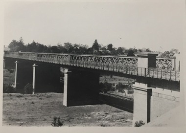
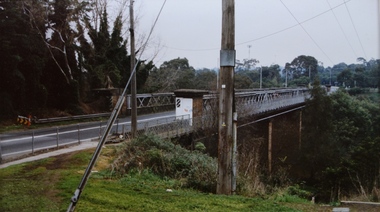
Photograph - Outer Circle Railway Viaduct
... ...Fairfield Bridge...The heritage listed Fairfield Bridge was originally constructed for the Outer Circle Railway to bridge the Yarra River between East Kew and Fairfield stations. ...Fairfield. The original photo predates the conversion of the viaduct into the Chandler Highway Bridge in the 1930s, when the Bridge was adapted to carry vehicular traffic. ...Kew Historical Society Inc Kew Court House 188 High Street Kew melbourne The heritage listed Fairfield Bridge was originally constructed for the Outer Circle Railway to bridge the Yarra River between East Kew and Fairfield stations. ...The heritage listed Fairfield Bridge was originally constructed for the Outer Circle Railway to bridge the Yarra River between East Kew and Fairfield stations. In the 1930s it was converted for vehicular traffic. In the 2010s a new concrete bridge was erected beside it to increase vehicular capacity.Print copy, enlarged from original snapshot, of the former railway viaduct crossing the Yarra and linking Kew and Fairfield. The original photo predates the conversion of the viaduct into the Chandler Highway Bridge in the 1930s, when the Bridge was adapted to carry vehicular traffic. The date on the reverse indicates the date of donation rather than the date on which the photograph was taken. CHANDLER HIGHWAY BRIDGE OVER RIVER / (ORIGINALLY PART OF OUTER CURCLE RAILWAY) / OCTOBER 1977railway viaduct -- kew (vic.), fairfield bridge, fairfield railway viaduct, outer circle railway, sir john monash -
 Kew Historical Society Inc
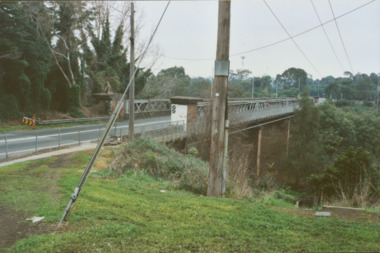
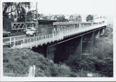
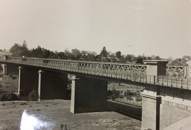
Photograph - Former Chandler Highway Bridge, 2001
... ...Fairfield bridge...The heritage listed Fairfield Bridge was originally constructed for the Outer Circle Railway to bridge the Yarra River between East Kew and Fairfield stations. ...Original colour print positive of the (former) Chandler Highway bridge in 2001. The point of view is from the Fairfield side of the river looking towards Kew. ...Ink inscription on reverse: "Chandler Highway bridge / (Originally Outer Circle Railway Bridge) / From Fairfield side towards Kew / July 2001"...Kew Historical Society Inc Kew Court House 188 High Street Kew melbourne The heritage listed Fairfield Bridge was originally constructed for the Outer Circle Railway to bridge the Yarra River between East Kew and Fairfield stations. ...The heritage listed Fairfield Bridge was originally constructed for the Outer Circle Railway to bridge the Yarra River between East Kew and Fairfield stations. In the 1930s it was converted for vehicular traffic. In the 2010s a new concrete bridge was erected beside it to increase vehicular capacity. Original colour print positive of the (former) Chandler Highway bridge in 2001. The point of view is from the Fairfield side of the river looking towards Kew. The heritage listed bridge was originally constructed for the Outer Circle Railway to bridge the Yarra River between East Kew and Fairfield stations. In the 1930s it was converted for vehicular traffic. In the 2010s a new concrete bridge was erected beside it to increase vehicular capacity. Ink inscription on reverse: "Chandler Highway bridge / (Originally Outer Circle Railway Bridge) / From Fairfield side towards Kew / July 2001"bridges -- kew (vic), fairfield bridge, chandler highway bridge, outer circle railway viaduct -
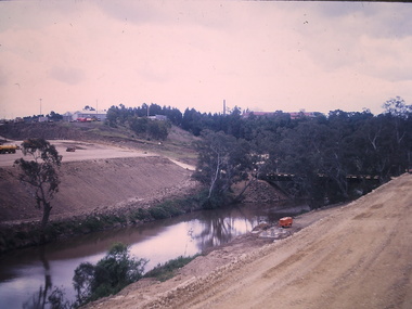
![Photograph - Construction of the F19 [Eastern Freeway], Ron Setford, January 1977](/media/collectors/550653872162f11fb04854aa/items/6808c6dc025de50d1e73affc/item-media/6808c6f7025de50d1e73b2c2/item-fit-380x285.jpg?cb=6) Kew Historical Society Inc
Kew Historical Society IncPhotograph - Construction of the F19 [Eastern Freeway], Ron Setford, January 1977
... "Freeway / Kew Fairfield Bridges"...Ron Setford Eastern Freeway F19 Freeway "Freeway / Kew Fairfield Bridges" Photograph Construction of the F19 [Eastern Freeway] Ron Setford ...Ron Setford and his wife Grace Setford lived in Tanner Avenue, East Kew, from c.1946 to c.1995. A keen photographer, he recorded the changing face of Kew over a 20 year period. Apart from 30 photographs of built structures and places in Kew dating from 1960 and 1961, 145 of his 35mm colour slides chronicle the development of the F19 (later renamed Eastern) Freeway through the Yarra Valley in Kew over a five year period from c.1972 to c.1977. This important collection was donated to the Society by his granddaughter in 2025.This collection of 175 35mm slides is of local and statewide significance, owing to its subject matter, particularly the major development of road transport infrastructure during the 1970s with the construction of the Eastern Freeway. The photographer also took care to annotate and date most of his slides which enable the researcher to pinpoint temporal and spatial locations."Freeway / Kew Fairfield Bridges"ron setford, eastern freeway, f19 freeway -
![Photograph - Construction of the F19 [Eastern Freeway], Ron Setford, January 1977](/media/collectors/550653872162f11fb04854aa/items/6808c850025de50d1e73cadc/item-media/6808c875025de50d1e73cdae/item-fit-380x285.jpg?cb=6) Kew Historical Society Inc
Kew Historical Society IncPhotograph - Construction of the F19 [Eastern Freeway], Ron Setford, January 1977
... "Freeway / Kew - Fairfield Bridges"...Ron Setford Eastern Freeway F19 Freeway "Freeway / Kew - Fairfield Bridges" Photograph Construction of the F19 [Eastern Freeway] Ron Setford ...Ron Setford and his wife Grace Setford lived in Tanner Avenue, East Kew, from c.1946 to c.1995. A keen photographer, he recorded the changing face of Kew over a 20 year period. Apart from 30 photographs of built structures and places in Kew dating from 1960 and 1961, 145 of his 35mm colour slides chronicle the development of the F19 (later renamed Eastern) Freeway through the Yarra Valley in Kew over a five year period from c.1972 to c.1977. This important collection was donated to the Society by his granddaughter in 2025.This collection of 175 35mm slides is of local and statewide significance, owing to its subject matter, particularly the major development of road transport infrastructure during the 1970s with the construction of the Eastern Freeway. The photographer also took care to annotate and date most of his slides which enable the researcher to pinpoint temporal and spatial locations."Freeway / Kew - Fairfield Bridges"ron setford, eastern freeway, f19 freeway -
![Photograph - Construction of the F19 [Eastern Freeway], Ron Setford, January 1977](/media/collectors/550653872162f11fb04854aa/items/6808c8dd025de50d1e73d331/item-media/6808c8ff025de50d1e73d73b/item-fit-380x285.jpg?cb=6) Kew Historical Society Inc
Kew Historical Society IncPhotograph - Construction of the F19 [Eastern Freeway], Ron Setford, January 1977
... "Freeway / Kew Fairfield Bridges"...Ron Setford Eastern Freeway F19 Freeway "Freeway / Kew Fairfield Bridges" Photograph Construction of the F19 [Eastern Freeway] Ron Setford ...Ron Setford and his wife Grace Setford lived in Tanner Avenue, East Kew, from c.1946 to c.1995. A keen photographer, he recorded the changing face of Kew over a 20 year period. Apart from 30 photographs of built structures and places in Kew dating from 1960 and 1961, 145 of his 35mm colour slides chronicle the development of the F19 (later renamed Eastern) Freeway through the Yarra Valley in Kew over a five year period from c.1972 to c.1977. This important collection was donated to the Society by his granddaughter in 2025.This collection of 175 35mm slides is of local and statewide significance, owing to its subject matter, particularly the major development of road transport infrastructure during the 1970s with the construction of the Eastern Freeway. The photographer also took care to annotate and date most of his slides which enable the researcher to pinpoint temporal and spatial locations."Freeway / Kew Fairfield Bridges"ron setford, eastern freeway, f19 freeway -
![Photograph - Construction of the F19 [Eastern Freeway], Ron Setford, January 1977](/media/collectors/550653872162f11fb04854aa/items/68287b8764071e7c58e66597/item-media/68287bc964071e7c58e66779/item-fit-380x285.jpg?cb=6) Kew Historical Society Inc
Kew Historical Society IncPhotograph - Construction of the F19 [Eastern Freeway], Ron Setford, January 1977
... "Freeway / Kew - Fairfield Bridges"...Ron Setford Eastern Freeway F19 Freeway "Freeway / Kew - Fairfield Bridges" Photograph Construction of the F19 [Eastern Freeway] Ron Setford ...Ron Setford and his wife Grace Setford lived in Tanner Avenue, East Kew, from c.1946 to c.1995. A keen photographer, he recorded the changing face of Kew over a 20 year period. Apart from 30 photographs of built structures and places in Kew dating from 1960 and 1961, 145 of his 35mm colour slides chronicle the development of the F19 (later renamed Eastern) Freeway through the Yarra Valley in Kew over a five year period from c.1972 to c.1977. This important collection was donated to the Society by his granddaughter in 2025.This collection of 175 35mm slides is of local and statewide significance, owing to its subject matter, particularly the major development of road transport infrastructure during the 1970s with the construction of the Eastern Freeway. The photographer also took care to annotate and date most of his slides which enable the researcher to pinpoint temporal and spatial locations."Freeway / Kew - Fairfield Bridges"ron setford, eastern freeway, f19 freeway -
![Photograph - Construction of the F19 [Eastern Freeway], Ron Setford, January 1977](/media/collectors/550653872162f11fb04854aa/items/683bd42569688f11138e678b/item-media/683bd46269688f11138e6862/item-fit-380x285.jpg?cb=6) Kew Historical Society Inc
Kew Historical Society IncPhotograph - Construction of the F19 [Eastern Freeway], Ron Setford, January 1977
... "Freeway / Kew Fairfield Bridges"...Ron Setford Eastern Freeway F19 Freeway "Freeway / Kew Fairfield Bridges" Photograph Construction of the F19 [Eastern Freeway] Ron Setford ...Ron Setford and his wife Grace Setford lived in Tanner Avenue, East Kew, from c.1946 to c.1995. A keen photographer, he recorded the changing face of Kew over a 20 year period. Apart from 30 photographs of built structures and places in Kew dating from 1960 and 1961, 145 of his 35mm colour slides chronicle the development of the F19 (later renamed Eastern) Freeway through the Yarra Valley in Kew over a five year period from c.1972 to c.1977. This important collection was donated to the Society by his granddaughter in 2025.This collection of 175 35mm slides is of local and statewide significance, owing to its subject matter, particularly the major development of road transport infrastructure during the 1970s with the construction of the Eastern Freeway. The photographer also took care to annotate and date most of his slides which enable the researcher to pinpoint temporal and spatial locations."Freeway / Kew Fairfield Bridges"ron setford, eastern freeway, f19 freeway -
![Photograph - Construction of the F19 [Eastern Freeway], Ron Setford, January 1977](/media/collectors/550653872162f11fb04854aa/items/683bd4de69688f11138e6afa/item-media/683bd50569688f11138e6d14/item-fit-380x285.jpg?cb=6) Kew Historical Society Inc
Kew Historical Society IncPhotograph - Construction of the F19 [Eastern Freeway], Ron Setford, January 1977
... "Freeway / Kew - Fairfield Bridges"...Ron Setford Eastern Freeway F19 Freeway "Freeway / Kew - Fairfield Bridges" Photograph Construction of the F19 [Eastern Freeway] Ron Setford ...Ron Setford and his wife Grace Setford lived in Tanner Avenue, East Kew, from c.1946 to c.1995. A keen photographer, he recorded the changing face of Kew over a 20 year period. Apart from 30 photographs of built structures and places in Kew dating from 1960 and 1961, 145 of his 35mm colour slides chronicle the development of the F19 (later renamed Eastern) Freeway through the Yarra Valley in Kew over a five year period from c.1972 to c.1977. This important collection was donated to the Society by his granddaughter in 2025.This collection of 175 35mm slides is of local and statewide significance, owing to its subject matter, particularly the major development of road transport infrastructure during the 1970s with the construction of the Eastern Freeway. The photographer also took care to annotate and date most of his slides which enable the researcher to pinpoint temporal and spatial locations."Freeway / Kew - Fairfield Bridges"ron setford, eastern freeway, f19 freeway -
![Photograph - Construction of the F19 [Eastern Freeway], Ron Setford, January 1977](/media/collectors/550653872162f11fb04854aa/items/683bd56369688f11138e6e9c/item-media/683bd58d69688f11138e709a/item-fit-380x285.jpg?cb=6) Kew Historical Society Inc
Kew Historical Society IncPhotograph - Construction of the F19 [Eastern Freeway], Ron Setford, January 1977
... "Freeway / Kew - Fairfield Bridges"...Ron Setford Eastern Freeway F19 Freeway "Freeway / Kew - Fairfield Bridges" Photograph Construction of the F19 [Eastern Freeway] Ron Setford ...Ron Setford and his wife Grace Setford lived in Tanner Avenue, East Kew, from c.1946 to c.1995. A keen photographer, he recorded the changing face of Kew over a 20 year period. Apart from 30 photographs of built structures and places in Kew dating from 1960 and 1961, 145 of his 35mm colour slides chronicle the development of the F19 (later renamed Eastern) Freeway through the Yarra Valley in Kew over a five year period from c.1972 to c.1977. This important collection was donated to the Society by his granddaughter in 2025.This collection of 175 35mm slides is of local and statewide significance, owing to its subject matter, particularly the major development of road transport infrastructure during the 1970s with the construction of the Eastern Freeway. The photographer also took care to annotate and date most of his slides which enable the researcher to pinpoint temporal and spatial locations."Freeway / Kew - Fairfield Bridges"ron setford, eastern freeway, f19 freeway -
![Photograph - Construction of the F19 [Eastern Freeway], Ron Setford, May 1976](/media/collectors/550653872162f11fb04854aa/items/6815adc98b33318343788a83/item-media/6815adff8b33318343788c4d/item-fit-380x285.jpg?cb=6) Kew Historical Society Inc
Kew Historical Society IncPhotograph - Construction of the F19 [Eastern Freeway], Ron Setford, May 1976
... "Pile driving Kew - Fairfield bridges"...Ron Setford Eastern Freeway F19 Freeway "Pile driving Kew - Fairfield bridges" Photograph Construction of the F19 [Eastern Freeway] Ron Setford ...Ron Setford and his wife Grace Setford lived in Tanner Avenue, East Kew, from c.1946 to c.1995. A keen photographer, he recorded the changing face of Kew over a 20 year period. Apart from 30 photographs of built structures and places in Kew dating from 1960 and 1961, 145 of his 35mm colour slides chronicle the development of the F19 (later renamed Eastern) Freeway through the Yarra Valley in Kew over a five year period from c.1972 to c.1977. This important collection was donated to the Society by his granddaughter in 2025.This collection of 175 35mm slides is of local and statewide significance, owing to its subject matter, particularly the major development of road transport infrastructure during the 1970s with the construction of the Eastern Freeway. The photographer also took care to annotate and date most of his slides which enable the researcher to pinpoint temporal and spatial locations."Pile driving Kew - Fairfield bridges"ron setford, eastern freeway, f19 freeway -
 Kew Historical Society Inc
Book, Stories They Tell : A history of Kew through objects, 2022
... ...Fairfield bridge...Each item selected is full pictured in colour. collection -- kew historical society museum catalogues Henty family Cartwheel pennies kew lunatic asylum patchwork quilts John Carson george bouchier richardson gb richardson Coombs family James dannock back to kew 1875 Francis Barnard Denbigh family Cullis Hill & Co Ordsall Southesk Kew Volunteer fire brigade jfc farquhar Henry kellett MMBW Detail Plan 1580 William Nicholls Anderson Young Workers patriotic guild Roll of honor -- town of kew Alice Anderson Kew War Memorial flapper dresses Fairfield bridge chandler highway bridge warren trestrail furniture -- 1930s war savings streets Kew Library children's libraries Voluntary aid detachments - Kew (Vic.) ...'Stories They Tell : A history of Kew through objects' explores diverse narratives from European settlement to the first decades of the twenty-first century. These stories use as their starting point artworks, texts and artefacts from the nationally significant collection of the Kew Historical Society. Limited to 100 copies.117 pp : illustrated : Appendices Chapters: Preface / Robert Baker p4. The collection / Robert Baker p5. Cartwheel penny / Robert Baker p6. Creek and old watering stage / David White p10. John Carson: Mayor 1863–4 1 / Julie King p4. Wedding dress / Suzanne McWha p18. Back to Kew 1875 / Judith Scurfield p22. Barnard’s clock / Margaret Robinson p26. Denbigh quilt / Suzanne McWha p28. Fragments of art decoration / Robert Baker p32. Mr Richardson’s sock / Felicity Renowden p36. Kew Volunteer Fire Brigade / David White p38. Kew Where We Live / Judith Scurfield p42. [MMBW} Detail Plan No. 1580 / Judith Scurfield p46. Adeney Avenue / Suzanne McWha p50. Young Workers’ Patriotic Guild / Margaret Robinson p54. Roll of Honor [Thomas Rand] / Robert Baker p56. Alice Anderson in her tourer / Felicity Renowden p60. Kew War Memorial / David White p62. Beaded dance dress / Suzanne McWha p 66. The great flood of 1934 / Desley Reid p68. Depression-era toolbox / Robert Baker p72. War Savings Street / Julie King p74. Kew Public L.ibrary / Suzanne McWha p78. Signature supper cloth / Desley Reid p82. View from the garden of Rockingham / Desley Reid p86. Cr Marie Dalley / Felicity Renowden p90. Centenary of Kew / Robert Baker p94. Doris Dickinson’s gown / Julie King p98. [Model Dairy] Milk bottles / Robert Baker p100. Kew Civic Centre / David White p102. Bicentennial tapestries / Margaret Robinson p106. Crest of the City of Kew / Desley Reid p110. Town Crier [outfit] / Desley Reid p112. Acknowledgements p114. List of works p115.non-fiction'Stories They Tell : A history of Kew through objects' explores diverse narratives from European settlement to the first decades of the twenty-first century. These stories use as their starting point artworks, texts and artefacts from the nationally significant collection of the Kew Historical Society. Limited to 100 copies.collection -- kew historical society, museum catalogues, henty family, cartwheel pennies, kew lunatic asylum, patchwork quilts, john carson, george bouchier richardson, gb richardson, coombs family, james dannock, back to kew 1875, francis barnard, denbigh family, cullis hill & co, ordsall, southesk, kew volunteer fire brigade, jfc farquhar, henry kellett, mmbw detail plan 1580, william nicholls anderson, young workers patriotic guild, roll of honor -- town of kew, alice anderson, kew war memorial, flapper dresses, fairfield bridge, chandler highway bridge, warren trestrail, furniture -- 1930s, war savings streets, kew library, children's libraries, voluntary aid detachments - kew (vic.), rockingham, james govett, centenary of kew, mayoresses -- kew (vic.), model dairy -- kew (vic.), doris dickinson, crests -- city of kew (vic.), town criers -- kew (vic.), joy stewart, australian bicentennial -- kew (vic.), kew civic centre, ak lines mcfarlane marshall, adeney avenue -- kew, wwi -
![Photograph - Construction of the F19 [Eastern Freeway], Ron Setford, December 1977](/media/collectors/550653872162f11fb04854aa/items/683bd7b769688f11138e7f2c/item-media/683bd7da69688f11138e80fc/item-fit-380x285.jpg?cb=6) Kew Historical Society Inc
Kew Historical Society IncPhotograph - Construction of the F19 [Eastern Freeway], Ron Setford, December 1977
... "Fairfield River Bridges towards city"...Ron Setford Eastern Freeway F19 Freeway "Fairfield River Bridges towards city" Photograph Construction of the F19 [Eastern Freeway] Ron Setford ...Ron Setford and his wife Grace Setford lived in Tanner Avenue, East Kew, from c.1946 to c.1995. A keen photographer, he recorded the changing face of Kew over a 20 year period. Apart from 30 photographs of built structures and places in Kew dating from 1960 and 1961, 145 of his 35mm colour slides chronicle the development of the F19 (later renamed Eastern) Freeway through the Yarra Valley in Kew over a five year period from c.1972 to c.1977. This important collection was donated to the Society by his granddaughter in 2025.This collection of 175 35mm slides is of local and statewide significance, owing to its subject matter, particularly the major development of road transport infrastructure during the 1970s with the construction of the Eastern Freeway. The photographer also took care to annotate and date most of his slides which enable the researcher to pinpoint temporal and spatial locations."Fairfield River Bridges towards city"ron setford, eastern freeway, f19 freeway -
![Photograph - Construction of the F19 [Eastern Freeway], Ron Setford, October 1973](/media/collectors/550653872162f11fb04854aa/items/6808c3e9025de50d1e73220c/item-media/6808c404025de50d1e7324ef/item-fit-380x285.jpg?cb=6) Kew Historical Society Inc
Kew Historical Society IncPhotograph - Construction of the F19 [Eastern Freeway], Ron Setford, October 1973
... "Eastern Freeway / Chandler H/way to Fairfield / River Bridge Oct 73"...Ron Setford Eastern Freeway F19 Freeway "Eastern Freeway / Chandler H/way to Fairfield / River Bridge Oct 73" Photograph Construction of the F19 [Eastern Freeway] Ron Setford ...Ron Setford and his wife Grace Setford lived in Tanner Avenue, East Kew, from c.1946 to c.1995. A keen photographer, he recorded the changing face of Kew over a 20 year period. Apart from 30 photographs of built structures and places in Kew dating from 1960 and 1961, 145 of his 35mm colour slides chronicle the development of the F19 (later renamed Eastern) Freeway through the Yarra Valley in Kew over a five year period from c.1972 to c.1977. This important collection was donated to the Society by his granddaughter in 2025.This collection of 175 35mm slides is of local and statewide significance, owing to its subject matter, particularly the major development of road transport infrastructure during the 1970s with the construction of the Eastern Freeway. The photographer also took care to annotate and date most of his slides which enable the researcher to pinpoint temporal and spatial locations."Eastern Freeway / Chandler H/way to Fairfield / River Bridge Oct 73"ron setford, eastern freeway, f19 freeway -
 Kew Historical Society Inc
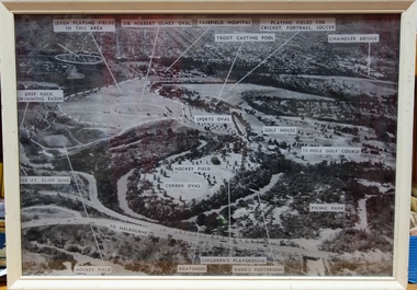
Photograph, Yarra Bend Park Trust, Yarra Bend Park Facilities, 1940s
... ...fairfield hospital...chandler bridge...Kew Historical Society Inc Kew Court House 188 High Street Kew melbourne Old aerial photograph of Yarra bend Park labelled with park facilities yarra bend park sports facilities - kew - fairfield sir herbert olney oval fairfield hospital chandler bridge deep rock swimming basin kane's footbridge Framed annotated aerial photograph of Yarra Bend Park. ...Old aerial photograph of Yarra bend Park labelled with park facilitiesFramed annotated aerial photograph of Yarra Bend Park. The white frame is original to the work.yarra bend park, sports facilities - kew - fairfield, sir herbert olney oval, fairfield hospital, chandler bridge, deep rock swimming basin, kane's footbridge -
 Kew Historical Society Inc
Photograph - Chandler Highway Bridge, 1977
... The heritage listed Fairfield Bridge was originally constructed for the Outer Circle Railway to bridge the Yarra River between East Kew and Fairfield stations. ...Print copy of the Chandler Highway Bridge, [formerly the Fairfield Viaduct of the Outer Circle Railway] showing the original position of the walkway beside the bridge. ...Kew Historical Society Inc Kew Court House 188 High Street Kew melbourne The heritage listed Fairfield Bridge was originally constructed for the Outer Circle Railway to bridge the Yarra River between East Kew and Fairfield stations. ...The heritage listed Fairfield Bridge was originally constructed for the Outer Circle Railway to bridge the Yarra River between East Kew and Fairfield stations. In the 1930s it was converted for vehicular traffic. In the 2010s a new concrete bridge was erected beside it to increase vehicular capacity.Print copy of the Chandler Highway Bridge, [formerly the Fairfield Viaduct of the Outer Circle Railway] showing the original position of the walkway beside the bridge. The POV is from the Fairfield side looking towards Kew. CHANDLER HWY BRIDGE OVER YARRA / OCTOBER 1977 / ORIGINALLY BUILT FOR OUTER CIRCLE RWYchandler highway bridge, outer circle railway viaduct, bridges -- kew (vic.) -
 Kew Historical Society Inc
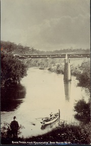
Postcard, River Yarra near Macauleys' Boathouse Kew, c.1910
... The Pipe Bridge was constructed to bring fresh water from Fairfield to Kew. This bridge was destroyed in the 1934 Flood and later reconstructed....Reverse: "(Pipe Water Line) / Kew to Fairfield above boat house / Pipe Bridge / Received from L. Bennett 1980"....Kew Historical Society Inc Kew Court House 188 High Street Kew melbourne The Pipe Bridge was constructed to bring fresh water from Fairfield to Kew. This bridge was destroyed in the 1934 Flood and later reconstructed. bridges - kew (vic.) bridges - yarra river -- kew (vic.) pipe bridge Obverse: "River Yarra near Macauleys' Boat House Kew". ...The Pipe Bridge was constructed to bring fresh water from Fairfield to Kew. This bridge was destroyed in the 1934 Flood and later reconstructed.Early sepia real photo postcard of the first Pipe Bridge bringing water from the Yan Yean Reservoir to Kew. The site is upriver of the original Macauley's boathouse. Obverse: "River Yarra near Macauleys' Boat House Kew". Reverse: "(Pipe Water Line) / Kew to Fairfield above boat house / Pipe Bridge / Received from L. Bennett 1980".bridges - kew (vic.), bridges - yarra river -- kew (vic.), pipe bridge -
 Warrnambool and District Historical Society Inc.
Framed Paintings, 1 The Frame Shop, Fairfield, Melbourne .2 Kardinia Picture Framing, Geelong, 1Warrnambool Botanical Gardens .2 Hopkins River, Warrnambool, 1953
... bridge, Lyndoch bungalow and boathouse. The frame is wooden with a mottled varnish and a white insert edging. .1Warrnambool Botanical Gardens .2 Hopkins River, Warrnambool Framed Paintings .1 The Frame Shop, Fairfield, Melbourne .2 Kardinia Picture Framing, Geelong ...These two works of art are by Dr Don Edgar, a sociologist, educator and author. He taught sociology at Stanford University, the University of Chicago, Monash University and La Trobe University and was the founding Director of the Australian Institute of Family Studies. In the 1950s Dr Edgar was a student at Warrnambool High School and these works of art were produced at that time. For a school project he researched the early history of the Warrnambool Art Gallery and some of its collection, dating from the 19th century. In 2019 he published a book, ‘Art For the Country’, the story of Victoria’s regional art galleries and the book includes information on the founding and the later history of the Warrnambool Art Gallery.These works of art are of interest as they were painted by Dr Don Edgar, a noted academic and author today and a former resident of Warrnambool. The two works of art also have historical interest as they depict Warrnambool scenes painted over 60 years ago. .1 An art work (oil on artboard) – the Warrnambool Botanical Gardens with bridge and reflections, a gum tree and a poplar tree, all in green and orange tonings. The wooden frame has a light varnish with gold and white trim .2 An art work (oil on artboard) – multi-coloured view of the mouth of Hopkins River with the Hopkins River bridge, Lyndoch bungalow and boathouse. The frame is wooden with a mottled varnish and a white insert edging. .1 Don Edgar 1953 Don Edgar 1953 (High School Student) .2 D.E. 53 Don Edgar 1953 (High School Student) dr don edgar, sociologist, author and educator, warrnambool art gallery, history of warrnambool -
 Eltham District Historical Society Inc
Document - Folder, Spence, Maxwell
... Fairfield RSL Youth Club...Bristcoes Hardware Merchants...Montmorency RSL...Jack Shallard...Ted Weiland...Petrie Park...South Riding Ratepaers and Tenants Association...Dr Keith Alexander...Fred Durham...Eltham Shire Council...Meruka Park...Max Watson...Eric Harmer...Spence Park Montmorency...Mountain View Railway Bridge...Maxwell Spence Briar Hill Montmorency Fernside Avenue Briar Hill Montmorency State School Were Street Montmorency Briar Hill State School Stan Stainsby Hee Alcock Ned Haughton Australian Paper Mills Lovitool Tomasetti baker of Greensborough Gladstone Avenue Briar Hill Beaconsfield Road Briar Hill Williams Road Briar Hill Ellis family Hillcrest playfield field Ben Barnett Bill Slater Colin Pugh Clifton Pugh St Helena Karingal Drive St Helena Ted Walker Weidligh Roslind Miller Graham Kennedy Jimmy Beale Leach Street St Helena Plenty River St Faith's Chrch of England Briar Hil St Andrew's Church Briar Hill St Francis Xavier Catholic Church Briar Hill Herbie Wilson Victoria Coffee Palace Eltham Higher Elementary School Kate McKenie Diamond Creek Frank Phillips Wingrove Park Bremner's Park Orrs Dam Pecks Dam Wal Scriver Montmorency Tennis Club Albert Price Hill Fred Balaam Greensborough RSL Joe Poulter Fairfield RSL Youth Club Bristcoes Hardware Merchants Montmorency RSL Jack Shallard Ted Weiland Petrie Park South Riding Ratepaers and Tenants Association Dr Keith Alexander Fred Durham Eltham Shire Council Meruka Park Max Watson Eric Harmer Spence Park Montmorency Mountain View Railway Bridge Montmrency Pre School Lower Plenty Fire Brigade Eltham High School Newspaper clippings, A4 photocopies, etc Spence, Maxwell Document Folder ...Max Spence came to Briar Hill as a child in 1923, and lived in the area for many years. Contents Typed and manuscript notes (2pp missing from MS), undated but ?c1990. "Spence: My Briar Hill and Montmorency." Reminiscences of Maxwell Spence of Briar Hill and Montmorency from 1923. Manuscript notes, AGM 1991, "Max Spence". Newspaper clippings, A4 photocopies, etcmaxwell spence, briar hill, montmorency, fernside avenue briar hill, montmorency state school, were street montmorency, briar hill state school, stan stainsby, hee alcock, ned haughton, australian paper mills, lovitool, tomasetti baker of greensborough, gladstone avenue briar hill, beaconsfield road briar hill, williams road briar hill, ellis family, hillcrest playfield field, ben barnett, bill slater, colin pugh, clifton pugh, st helena, karingal drive st helena, ted walker, weidligh, roslind miller, graham kennedy, jimmy beale, leach street st helena, plenty river, st faith's chrch of england briar hil, st andrew's church briar hill, st francis xavier catholic church briar hill, herbie wilson, victoria coffee palace, eltham higher elementary school, kate mckenie, diamond creek, frank phillips, wingrove park, bremner's park, orrs dam, pecks dam, wal scriver, montmorency tennis club, albert price hill, fred balaam, greensborough rsl, joe poulter, fairfield rsl youth club, bristcoes hardware merchants, montmorency rsl, jack shallard, ted weiland, petrie park, south riding ratepaers and tenants association, dr keith alexander, fred durham, eltham shire council, meruka park, max watson, eric harmer, spence park montmorency, mountain view railway bridge, montmrency pre school, lower plenty fire brigade, eltham high school -
 Kew Historical Society Inc
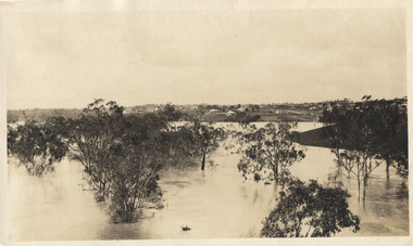
Photograph, Marnie McLeod, Floods on the River Yarra at Kew, 1916
... Panoramic view, believed to be looking north towards Fairfield from the Zig-Zag Bridge on the River Yarra. The inscription on the reverese identifies it as taken before 1920....Together with our original MMBW River Yarra map showing flood levels, these items, when compared allow researchers to gain a visual perspective of the extent of the flood in 1916. river yarra kew floods 1916 zig-zag bridge Inscription on reverse in ink "(pre 1920) Flood from Zig-zag bridge Yarra River, Kew Vic." Panoramic view, believed to be looking north towards Fairfield from the Zig-Zag Bridge on the River Yarra. ...The donation was accompanied by the following letter from the donor: "Hi. I found these in with family photos. Taken by family as Mamie McLeod was living in Fellows Street, Kew, so would be near there. Retain (or discard) as you see fit." [Donor's name and address withheld from public view]. To gain an insight into the flood levels at Kew, it is worth reading newspaper accounts of the event. The Age published an article - Valuable Gardens Destroyed at Kew - on 25 September 1916: "VALUABLE GARDENS DESTROYED AT KEW. From the heights of Studley Park, Kew, a splendid view of the flood waters can be obtained, and yesterday afternoon, despite continuous rain, crowds of citizens assembled there to witness the spectacle. There is a vast stretch of water some 300 or 400 yards broad, above the foot bridge connecting Gipps-street, Collingwood, and Studley Park. The river is only about 3 feet from the top of the embankment connecting with the ramp of the bridge on the Studiey Park side. When the upper llood waters come down it is almost a certainty that tne embankment will be submerged and the bridge rendered impassible. Below the bridge the waters again stretch out, and have submerged all the low-lying land on the Collingwood side and invaded the back premises ot the Kodak Co., Phoenix Biscuit Factory, a tannery adjoining thereto, the Shamrock Brewery, and Chinese gardens in the vicinity. At Walmer-street-bridge, at the end of Studley Park, the low-lying land on the Kew side is covered with water to the depth of many feet. Tlie land in question is owned in a great part by Mr Frank Lavers who haa gone in for intense culture on a pretty liberal scale on both the slopes of the hill and on the river flat. On the latter he is cultivating many acres of asparagus, and has at a considerable cost spent three years in preparing the ground and installing an irrigation system, reticulated from the Yan Yean water supply. This year the asparagus was put down, and the plants were in a promising condition. Tlie flood waters are now flowing fast over the land. The crop is ruined, and three years' work and expenditure destroyed. Mr. Laver's private residence fortunately is high above flood level, but two houses he owns off Young-street have been flooded out. Having been warned in time, the tenants removed their furniture hefore the water came down to Mr. Laver's residence, where they themselves have been given accommodation in the meantime. All the river flats in East Kew are under water. One or two low-lying houses have been flooded. Chipperfield's boat shed at Willsmere is nearly covered, and some Chinese gardens in the vicinity are several feet under water."This, and the other three photographs donated of floods in Kew are believed to be the earliest in the collection. Together with our original MMBW River Yarra map showing flood levels, these items, when compared allow researchers to gain a visual perspective of the extent of the flood in 1916. Panoramic view, believed to be looking north towards Fairfield from the Zig-Zag Bridge on the River Yarra. The inscription on the reverese identifies it as taken before 1920.Inscription on reverse in ink "(pre 1920) Flood from Zig-zag bridge Yarra River, Kew Vic."river yarra, kew, floods 1916, zig-zag bridge -
 Kew Historical Society Inc
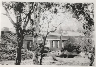
Photograph, Railway Viaduct, c.1919
... Fairfield. Built by John Monash for the Outer Circle Railway. In 1930 converted into the Chandler Highway Bridge for vehicular traffic. ...Annotations on reverse: "Outer Circle Railway Bridge (now Chandler Highway) Fairfield-Kew, about 1919. Property of Miss Foley....Kew Historical Society Inc Kew Court House 188 High Street Kew melbourne The railway viaduct linking Kew and Fairfield was created for the Outer Circle railway. outer circle railway railway viaduct (kew) john monash Annotations on reverse: "Outer Circle Railway Bridge (now Chandler Highway) Fairfield-Kew, about 1919. ...The railway viaduct linking Kew and Fairfield was created for the Outer Circle railway.Railway viaduct, Yarra River, linking Kew and Fairfield. Built by John Monash for the Outer Circle Railway. In 1930 converted into the Chandler Highway Bridge for vehicular traffic. The point-of-view of the photograph shows Kew in the distance. Annotations on reverse: "Outer Circle Railway Bridge (now Chandler Highway) Fairfield-Kew, about 1919. Property of Miss Foley.outer circle railway, railway viaduct (kew), john monash -
 Kew Historical Society Inc
Photograph, Railway Viaduct, c.1900
... Fairfield. Built by John Monash for the Outer Circle Railway. In 1930 converted into the Chandler Highway Bridge for vehicular traffic. ...Outer Circle Railway Bridge (over Yarra) looking from Kew side to site of Paper Mills, Alphington. Railway viaduct, Yarra River, linking Kew and Fairfield. ...Railway viaduct, Yarra River, linking Kew and Fairfield. Built by John Monash for the Outer Circle Railway. In 1930 converted into the Chandler Highway Bridge for vehicular traffic. Annotations on reverse: "KH-71. Outer Circle Railway Bridge (over Yarra) looking from Kew side to site of Paper Mills, Alphington.outer circle railway, railway viaduct (kew), john monash, chandler highway bridge -
 Kew Historical Society Inc
Photograph, Outer Circle Railway Viaduct, 1919
... Photograph of Outer Circle Railway Bridge over River Yarra, Fairfield. Looking toward Lugton Street, showing fence underneath taken from the Chandler Highway. ...Reverse: "Outer Circle Railway Bridge over River Yarra Fairfield, H0276, Property of Miss Foley"...Dateable photo of an important piece of Victorian railway infrastructure. railway viaduct chandler highway Reverse: "Outer Circle Railway Bridge over River Yarra Fairfield, H0276, Property of Miss Foley" Photograph of Outer Circle Railway Bridge over River Yarra, Fairfield. ...Railway Viaduct constructed for the Outer Circle Railway. Bridge designed by John Monash, engineer. Converted into a state highway, 1930s.Dateable photo of an important piece of Victorian railway infrastructure.Photograph of Outer Circle Railway Bridge over River Yarra, Fairfield. Looking toward Lugton Street, showing fence underneath taken from the Chandler Highway. Reverse: "Outer Circle Railway Bridge over River Yarra Fairfield, H0276, Property of Miss Foley"railway viaduct, chandler highway -
 Kew Historical Society Inc
Photograph, Chandler Highway Bridge, 1930s
... fairfield)...john monash...chandler highway bridge...The railway viaduct linking the Outer Circle railway from Kew to Fairfield was constructed in the 1890s. In the 1930s it was converted into a motorway bridge....Photocopy of a photograph of the bridge linking Kew and Fairfield. Dated to the 1930s following the construction off the Chanler Highway....Kew Historical Society Inc Kew Court House 188 High Street Kew melbourne The railway viaduct linking the Outer Circle railway from Kew to Fairfield was constructed in the 1890s. In the 1930s it was converted into a motorway bridge. outer circle railway viaduct (kew fairfield) john monash chandler highway bridge Photocopy of a photograph of the bridge linking Kew and Fairfield. ...The railway viaduct linking the Outer Circle railway from Kew to Fairfield was constructed in the 1890s. In the 1930s it was converted into a motorway bridge.Photocopy of a photograph of the bridge linking Kew and Fairfield. Dated to the 1930s following the construction off the Chanler Highway.outer circle railway, viaduct (kew fairfield), john monash, chandler highway bridge -
 Kew Historical Society Inc
Photograph, J F C Farquhar, Railway Bridge Over the Yarra, 1891
... Completed in November 1890, the railway viaduct (now the Chandler Highway Bridge) linked Kew and Fairfield. The viaduct is significant as the most substantial extant engineering remnant of the Outer Circle Railway Line. ...The individual images have proved essential in identifying buildings and places of heritage value in the district. kew illustrated kew where we live photographic books henry kellett railway viaduct - - kew (vic) Railway Bridge Over the Yarra Completed in November 1890, the railway viaduct (now the Chandler Highway Bridge) linked Kew and Fairfield. The viaduct is significant as the most substantial extant engineering remnant of the Outer Circle Railway Line. ...At the beginning of the 1890s, the Kew businessman and Town Councillor, Henry Kellett, commissioned J.F.C. Farquhar to photograph scenes of Kew. These scenes included panoramas as well as pastoral scenes. The resulting set of twelve photographs was assembled in an album, Kew Where We Live, from which customers could select images for purchase.The preamble to the album describes that the photographs used the ‘argentic bromide’ process, now more commonly known as the gelatine silver process. This form of dry plate photography allowed for the negatives to be kept for weeks before processing, hence its value in landscape photography. The resulting images were considered to be finely grained and everlasting. Evidence of the success of Henry Kellett’s venture can be seen today, in that some of the photographs are held in national collections.It is believed that the Kew Historical Society’s copy of the Kellett album is unique and that the photographs in the book were the first copies taken from the original plates. It is the first and most important series of images produced about Kew. The individual images have proved essential in identifying buildings and places of heritage value in the district.Completed in November 1890, the railway viaduct (now the Chandler Highway Bridge) linked Kew and Fairfield. The viaduct is significant as the most substantial extant engineering remnant of the Outer Circle Railway Line. Opened in March 1891, the viaduct crossed the Yarra River in a single span, atop three supporting brick pillars. Following the closure of the railway line in 1927, and the construction of the Chandler Highway in 1930, the bridge was used for vehicular traffic. In 1891 when this panoramic photograph was taken, the grounds of what was then the Kew Lunatic Asylum extended down to the River and eastward beyond the viaduct. The landscape surrounding the Asylum was planted with traditional exotic trees such as Oaks, Pines and Cedars, and landmark trees from northern Australia such as the Hoop Pine. Remnant indigenous trees such as the River Red Gum, Yellow Box and Lightwood were scattered around the site, including beside the Yarra River.Railway Bridge Over the Yarrakew illustrated, kew where we live, photographic books, henry kellett, railway viaduct - - kew (vic) -
 Kew Historical Society Inc
Photograph - Chandler Highway Bridge, Stewart West, 2001
... Colour photograph by Stuart West of the Chandler Highway Bridge from the Fairfield side of the River....Kew Historical Society Inc Kew Court House 188 High Street Kew melbourne chandler highway bridge stewart west Nil Colour photograph by Stuart West of the Chandler Highway Bridge from the Fairfield side of the River. Photograph Chandler Highway Bridge Stewart West ...Colour photograph by Stuart West of the Chandler Highway Bridge from the Fairfield side of the River.Nilchandler highway bridge, stewart west -
 Kew Historical Society Inc
Photograph - Construction of the Eastern Freeway (F19), Ron Setford, November 1972
... "Temporary across bridge at rear / New bridge embankments / Kew - Fairfield"...Ron Setford Eastern Freeway F19 Freeway "Temporary across bridge at rear / New bridge embankments / Kew - Fairfield" Photograph Construction of the Eastern Freeway (F19) Ron Setford ...Ron Setford and his wife Grace Setford lived in Tanner Avenue, East Kew, from c.1946 to c.1995. A keen photographer, he recorded the changing face of Kew over a 20 year period. Apart from 30 photographs of built structures and places in Kew dating from 1960 and 1961, 145 of his 35mm colour slides chronicle the development of the F19 (later renamed Eastern) Freeway through the Yarra Valley in Kew over a five year period from c.1972 to c.1977. This important collection was donated to the Society by his granddaughter in 2025.This collection of 175 35mm slides is of local and statewide significance, owing to its subject matter, particularly the major development of road transport infrastructure during the 1970s with the construction of the Eastern Freeway. The photographer also took care to annotate and date most of his slides which enable the researcher to pinpoint temporal and spatial locations."Temporary across bridge at rear / New bridge embankments / Kew - Fairfield"ron setford, eastern freeway, f19 freeway -
 Kew Historical Society Inc
Photograph - Construction of the Eastern Freeway (F19), Ron Setford, November 1972
... "New bridge approach / Embankments / Kew - Fairfield"...Ron Setford Eastern Freeway F19 Freeway "New bridge approach / Embankments / Kew - Fairfield" Photograph Construction of the Eastern Freeway (F19) Ron Setford ...Ron Setford and his wife Grace Setford lived in Tanner Avenue, East Kew, from c.1946 to c.1995. A keen photographer, he recorded the changing face of Kew over a 20 year period. Apart from 30 photographs of built structures and places in Kew dating from 1960 and 1961, 145 of his 35mm colour slides chronicle the development of the F19 (later renamed Eastern) Freeway through the Yarra Valley in Kew over a five year period from c.1972 to c.1977. This important collection was donated to the Society by his granddaughter in 2025.This collection of 175 35mm slides is of local and statewide significance, owing to its subject matter, particularly the major development of road transport infrastructure during the 1970s with the construction of the Eastern Freeway. The photographer also took care to annotate and date most of his slides which enable the researcher to pinpoint temporal and spatial locations."New bridge approach / Embankments / Kew - Fairfield"ron setford, eastern freeway, f19 freeway -
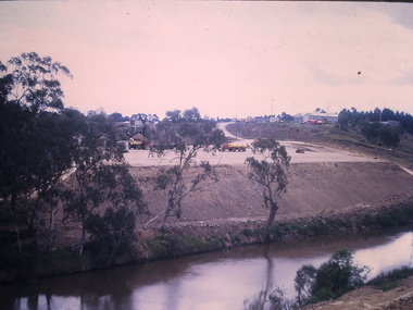
![Photograph - Construction of the F19 [Eastern Freeway], Ron Setford, ca. 1973](/media/collectors/550653872162f11fb04854aa/items/6804bf9ce716c23079f56c8e/item-media/6804bfc2e716c23079f56eab/item-fit-380x285.jpg?cb=6) Kew Historical Society Inc
Kew Historical Society IncPhotograph - Construction of the F19 [Eastern Freeway], Ron Setford, ca. 1973
... "Eastern Freeway / Bridge over river Fairfield - Kew / Hornibrook contractor"...Ron Setford Eastern Freeway F19 Freeway "Eastern Freeway / Bridge over river Fairfield - Kew / Hornibrook contractor" Photograph Construction of the F19 [Eastern Freeway] Ron Setford ...Ron Setford and his wife Grace Setford lived in Tanner Avenue, East Kew, from c.1946 to c.1995. A keen photographer, he recorded the changing face of Kew over a 20 year period. Apart from 30 photographs of built structures and places in Kew dating from 1960 and 1961, 145 of his 35mm colour slides chronicle the development of the F19 (later renamed Eastern) Freeway through the Yarra Valley in Kew over a five year period from c.1972 to c.1977. This important collection was donated to the Society by his granddaughter in 2025.This collection of 175 35mm slides is of local and statewide significance, owing to its subject matter, particularly the major development of road transport infrastructure during the 1970s with the construction of the Eastern Freeway. The photographer also took care to annotate and date most of his slides which enable the researcher to pinpoint temporal and spatial locations."Eastern Freeway / Bridge over river Fairfield - Kew / Hornibrook contractor"ron setford, eastern freeway, f19 freeway -
![Photograph - Construction of the F19 [Eastern Freeway], Ron Setford, May 1973](/media/collectors/550653872162f11fb04854aa/items/6804c045e716c23079f571fd/item-media/6804c1cce716c23079f5783e/item-fit-380x285.jpg?cb=6) Kew Historical Society Inc
Kew Historical Society IncPhotograph - Construction of the F19 [Eastern Freeway], Ron Setford, May 1973
... "Eastern Freeway / Bridge over Yarra / Kew-Fairfield / May 73"...Ron Setford Eastern Freeway F19 Freeway "Eastern Freeway / Bridge over Yarra / Kew-Fairfield / May 73" Photograph Construction of the F19 [Eastern Freeway] Ron Setford ...Ron Setford and his wife Grace Setford lived in Tanner Avenue, East Kew, from c.1946 to c.1995. A keen photographer, he recorded the changing face of Kew over a 20 year period. Apart from 30 photographs of built structures and places in Kew dating from 1960 and 1961, 145 of his 35mm colour slides chronicle the development of the F19 (later renamed Eastern) Freeway through the Yarra Valley in Kew over a five year period from c.1972 to c.1977. This important collection was donated to the Society by his granddaughter in 2025.This collection of 175 35mm slides is of local and statewide significance, owing to its subject matter, particularly the major development of road transport infrastructure during the 1970s with the construction of the Eastern Freeway. The photographer also took care to annotate and date most of his slides which enable the researcher to pinpoint temporal and spatial locations."Eastern Freeway / Bridge over Yarra / Kew-Fairfield / May 73"ron setford, eastern freeway, f19 freeway