Showing 261 items matching "fires 1939"
-
 Lakes Entrance Historical Society
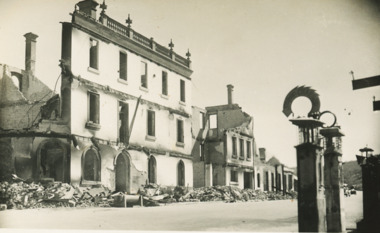
Postcard - Golden Age Hotel Omeo- Black Saturday Fires 1939, Bulmer
... Golden Age Hotel Omeo- Black Saturday Fires 1939...Friday 13 January 1939 showing ruins of the fires...Also a second postcard with a different view of the ruins of Omeo shops Day St Omeo January 1939 05384.1 8.5 x 14 cm Bushfires Natural Disasters Townships Friday 13 January 1939 showing ruins of the fires Black and white postcard showing remains of Golden Age Hotel after Black Saturday Bush fires Omeo Victoria Postcard Golden Age Hotel Omeo- Black Saturday Fires 1939 Bulmer ...Also a second postcard with a different view of the ruins of Omeo shops Day St Omeo January 1939 05384.1 8.5 x 14 cmBlack and white postcard showing remains of Golden Age Hotel after Black Saturday Bush fires Omeo VictoriaFriday 13 January 1939 showing ruins of the firesbushfires, natural disasters, townships -
 Lakes Entrance Historical Society
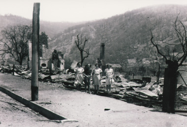
Photograph - After the Fires - Omeo 1939, 1/01/1939 12:00:00 AM
... After the Fires - Omeo 1939...Omeo after big fire 13 /1/ 1939...Also an enlarged copy of same photograph 05383.1 10 x 15 cm Fires Natural Disasters Omeo after big fire 13 /1/ 1939 Black and white photograph of Day Street showing ruins of burnt out shops after Black Saturday bush fires with four women looking at sight Omeo Victoria Photograph After the Fires - Omeo 1939 ...Also an enlarged copy of same photograph 05383.1 10 x 15 cmBlack and white photograph of Day Street showing ruins of burnt out shops after Black Saturday bush fires with four women looking at sight Omeo VictoriaOmeo after big fire 13 /1/ 1939fires, natural disasters -
 Save the Dandenongs League Inc.
Archive (item), Save the Dandenongs League Incorporated, Ash Regrowth from the 1939 Fires, and Other Papers
... Ash Regrowth from the 1939 Fires, and Other Papers...Ash Regrowth from the 1939 Fires, and Other Papers Archive Save the Dandenongs League Incorporated ... -
 Linton and District Historical Society Inc
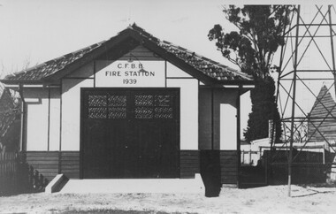
Photograph, New Linton Fire Brigade Building, 1939, 1939
... New Linton Fire Brigade Building, 1939...Black and white photograph printed as a postcard, which shows a building with large front doors standing next to a metal tower. "CFBB / FIRE STATION / 1939" across top of building.... Text: "CFBB / FIRE STATION / 1939"...."CFBB / FIRE STATION / 1939" across top of building. New Linton Fire Brigade Building, 1939 Photograph Photograph ...Black and white photograph printed as a postcard, which shows a building with large front doors standing next to a metal tower. "CFBB / FIRE STATION / 1939" across top of building. Text: "CFBB / FIRE STATION / 1939".linton fire brigade building, buildings -
Southern Sherbrooke Historical Society Inc.
Information folder - Ray Tremain
... ...fires 1939...Southern Sherbrooke Historical Society Inc. 127 Colby Drive Belgrave Heights 3160 yarra-valley-and-the-dandenong-ranges belgrave south state school fires 1939 Information folder pertaining to Ray Tremain. ...Information folder pertaining to Ray Tremain. Contents: -article, "Ray recalls the run of his life", Ferntree Gully Belgrave Mail, 20 January 2009belgrave south state school, fires 1939 -
 Kiewa Valley Historical Society
Photographs – Set of 9 black and white photographs and photocopies of original photographs depicting the early days of Bogong Village during the 1940’s, circa 1940's
... Bogong Village; 1939 fires; Kiewa Hydro Electric Scheme;...The road to Bogong had reached the lookout spur just beyond Roper’s Spur track just before the 1939 fires. The early forties saw rapid growth of the village, with single and married men’s quarters, workshops, mess huts and administrative offices. ...fires. (some official SECV photographs) 1. Bogong Village in heavy snow 2. Bogong Township during heavy snow (SECV Official Photo) 3. VIP Lodge at Bogong in the snow 4. Bogong Village - circa 1940’s 5. Bogong Village under street lights 6. Lewis Construction Camp (SECV Official Photo) 7. Albion Quarrying Co. Camp (SECV Official Photo) 8. Tent camp and early buildings following 1939...Bogong Village; 1939 fires; Kiewa Hydro Electric Scheme; 1. Handwritten under photo – August 1948 2. ...Bogong Village, which was known as “The Junction”, is well recorded. The first tent camp was at the junction of Pretty Valley and Rocky Valley streams in the early 40’s. Further downstream were the sawmill, stables and blacksmith’s forge. Horses were the main mode of transport in the early days. The road to Bogong had reached the lookout spur just beyond Roper’s Spur track just before the 1939 fires. The early forties saw rapid growth of the village, with single and married men’s quarters, workshops, mess huts and administrative offices. The facilities necessary for communal living were quickly in place- a post office, police station, co-op store, medical centre, community hall/theatre, tennis courts and school. Much of the temporary accommodation that housed groups such as the Albion Quarrying Company were in the area now under water.Pictorial history of the early years of Bogong Village including one photo taken following the devastating fires of 1939. Photos show the terrain in which Bogong Village was built, the early construction used for the temporary buildings and the housing and the amount of infrastructure required to accommodate the needs of the residents of the area including workers, their families and other support staff. Set of 9 black and white photographs and photocopies of photographs depicting early buildings at Bogong Village . Photos show very early construction buildings as well as the village in various weather conditions, including snowing and after bush fires. (some official SECV photographs) 1. Bogong Village in heavy snow 2. Bogong Township during heavy snow (SECV Official Photo) 3. VIP Lodge at Bogong in the snow 4. Bogong Village - circa 1940’s 5. Bogong Village under street lights 6. Lewis Construction Camp (SECV Official Photo) 7. Albion Quarrying Co. Camp (SECV Official Photo) 8. Tent camp and early buildings following 1939 fires 9. Typical house – Bogong Village 1. Handwritten under photo – August 1948 2. Printed under photo: STATE ELECTRICITY COMMISSION OF VICTORIA Date: 25.8.48 Time: 9am No:K 4680 Kiewa Hydro-Electric Works. Bogong Township 3. Handwritten on back of photo- V.I.P. Lodge, Bogong 4 – 5. No markings 6. Printed under photo: STATE ELECTRICITY COMMISSION OF VICTORIA Date: 28.11.40 Time: 1.40pm No:K284 Kiewa Hydro-Electric Works. Lewis Construction Camp 7. Printed under photo: STATE ELECTRICITY COMMISSION OF VICTORIA Date: 11.1.41 Time: 10.40am No:K294 Kiewa Hydro-Electric Works. Albion Quarrying Co. Camp – Bogong. Handwritten on back of photo: On the floor of the present dam 8. No markings 9. Printed under photo: STATE ELECTRICITY COMMISSION OF VICTORIA Date: 11.1.46 Time: 1.23pm No:K2181 Kiewa Hydro-Electric Works. Bogong – Typical House bogong village; 1939 fires; kiewa hydro electric scheme; -
 City of Melbourne Libraries
Photograph, Bull, Hugh Jones, 1897-1993, Fire at Cathedral Hotel, Swanston Street, Melbourne
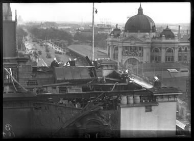
... fires...1930-1939...Retrieved February 5, 2024, from http://nla.gov.au/nla.news-article52000751 'Flinders Lane Melbourne 1966', Peter Andrew Barrett, Facebook, 12 June 2020, https://www.facebook.com/120943481324886/photos/a.512123662206864/3025002490918956/?type=3 fires 1930-1939 hotels Photographer notations on slide: "Fire at Cathedral Hotel Swanston St 1936 B104". ...Fire at the Cathedral Hotel! Southward view Firemen in their shiny brass Merryweather style helmets battle a fire in the roof of the Cathedral Hotel, Tuesday 3 March 1936. It was located on the corner of Swanston Street and Flinders Lane and so named for its proximity to St Paul’s Cathedral, just visible at top left. The fire broke out in between the roof space and wooden ceiling of the hotel at around 4.30 pm, causing disruption to afternoon commuters – hence the banked-up trams along St Kilda Road. The hoses snaking across the roof have been dragged up through the hotel’s front door. The scene of devastation on the roof appears to be a result of both the fire and firefighting efforts. The panoramic background is dominated by the dome of Flinders Street Station, the wide, treed boulevard of St Kilda Road, and a densely built-up industrial area south of the Yarra with its elevated signage and substantial buildings. Featured in "Newsworthy: Melbourne in photographs 1933-1936" exhibition at East Melbourne Library, October to December 2023. Exhibition caption by project volunteer, Louise McKenzie. Photographer notations on slide: "Fire at Cathedral Hotel Swanston St 1936 B104" Description: This photo, taken from an adjacent building, shows 12 firemen fighting a fire on the roof of the Cathedral Hotel, Melbourne. There is evidence of considerable damage to the roof of the building as a result of the fire and fire fighting efforts. The photo gives a feeling of elevation, as the firemen are in focus, with an out of focus panoramic background, showing the dome of Flinders Street Station, and St Kilda Road down to the Shrine. Research by project volunteer, Louise McKenzie: The Age reported on 4 March 1936 that the fire broke out in rubbish between the roof space and wooden ceiling of the Cathedral Hotel at 4.30 pm. “The Eastern Hill fire brigade was notified by telephone, and an almost simultaneous call was also received at fire brigade headquarters from a street alarm.” The firemen in their dark uniforms with brass buttons, gold epaulettes and shiny brass Merryweather helmets, stand out against the broken slate tiles and dislodged timber of the damaged roofing, all of which look blackened and in disarray. Two pale water hoses snake thickly across the roof. It is a scene of some devastation and chaos. Three chimney pots by contrast sit plump and strong against the damage. The Cathedral Hotel is located on the corner of Swanston Street and Flinders Lane, so named due to its proximity to St Pauls Cathedral (just visible at far left) on the corner of Flinders and Swanston streets. This intersection is a hub and focus of Melbourne activity. The backgrounded Melbourne skyline, while not in clear focus, is of interest. On the right is the impressive dome of Flinders Street Station, with the clock at 4.50 pm. Its grand frontage, and some of the façade along Flinders Street, are visible. To the left is the wide and grand-scaled St Kilda Road, leading down to the Shrine of Remembrance. There are many trams on Princes Bridge (mostly heading northward), together with some trucks and pedestrians. The pedestrian walkway along Princes Bridge is wide, and the Bridge balustrade lined with flag poles. The middle background shows a large number of trees. This was the site of Wirths Brothers Circus, an impressive complex including an octagonal circus Hippodrome (5000 seat auditorium), Pleasure Park, roller skating rink, and Dance Hall. Today it is the site of the Melbourne Arts Centre. Adjacent to the station is a large covered area, still extant today as part of the Station precinct. Floating above the horizon is sign advertising 'DUNLOP', located in the formerly industrial area which is today’s Southbank. Port Phillip Bay is faintly visible in the distance. The city seems sprawling, but uncrowded, and well punctuated by trees. Two photos were included an Age pictorial, one showing the firefighters at work, the other a crowd scene at street level (see References). These images are not part of the McKenzie Collection. References: No title (1936, March 4). The Age (Melbourne, Vic. : 1854 - 1954), p. 13. Retrieved February 5, 2024, from http://nla.gov.au/nla.news-article205256255 FIRE AT A CITY HOTEL. (1936, March 4). The Age (Melbourne, Vic. : 1854 - 1954), p. 12. Retrieved February 5, 2024, from http://nla.gov.au/nla.news-article205256231 FIRE IN ROOF OF CITY HOTEL (1936, March 4). The Argus (Melbourne, Vic. : 1848 - 1957), p. 8. Retrieved February 5, 2024, from http://nla.gov.au/nla.news-article11018696 Hotel Roof Fire Draws Crowd (1936, March 4). Examiner (Launceston, Tas. : 1900 - 1954), p. 8 (DAILY). Retrieved February 5, 2024, from http://nla.gov.au/nla.news-article52000751 'Flinders Lane Melbourne 1966', Peter Andrew Barrett, Facebook, 12 June 2020, https://www.facebook.com/120943481324886/photos/a.512123662206864/3025002490918956/?type=3Photographer notations on slide: "Fire at Cathedral Hotel Swanston St 1936 B104".fires, 1930-1939, hotels -
 City of Melbourne Libraries
Photograph, Bull, Hugh Jones, 1897-1993, Theatre Royal, Bourke Street
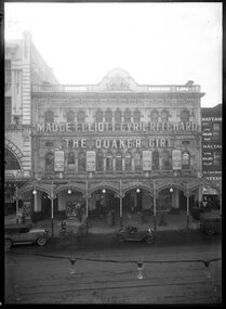
... 1939...fires...Retrieved March 25, 2026, from http://nla.gov.au/nla.news-article205554863 It's smart to be thrifty: the story of Manton's department store, Annette Cooper, https://www.slv.vic.gov.au/sites/default/files/3%20Annette%20Cooper%20-%20It%E2%80%99s%20smart%20to%20be%20thrifty%2C%20the%20story%20of%20Manton%27s%20department%20store.pdf theatres 1930-1939 fires musicals films department stores demolished buildings commemorative plaques incidents concrete Whelan the Wrecker bricks Kmart Bourke Street Melbourne Manton's department store Theatre Royal Coles Target Photographer notations on slide: "Theatre Royale 1933 B4". ...Closing time for the Theatre Royal Melbourne’s Theatre Royal opened 16 July 1855 at 236 Bourke Street, between Swanston and Russell, in the heart of the city’s entertainment district and it was comparable in size to London’s Drury Lane and Covent Garden. It was rebuilt in 1872 following a fire, remodelled in 1904, and demolished in 1933, due in part to the Great Depression, and also to the growing popularity of moving pictures. On the site was erected Manton’s department store, then Coles, Target, and now Kmart. The Quaker Girl, a 1910 Edwardian musical comedy with long running success in London, Paris and Broadway, opened in Melbourne at the Theatre Royal on 22 July 1933. Stars Cyril Ritchard and Madge Elliott were to become husband and wife, their Sydney wedding photograph now an iconic Australian image of that time. The theatre closed 13 November 1933. MCK080 Published: The Age 4 November 1933 Featured in "Newsworthy: Melbourne in photographs 1933-1936" exhibition at East Melbourne Library, October to December 2023. Exhibition caption by project volunteer, Louise McKenzie. THEATRE ROYAL (1933, November 4). The Age (Melbourne, Vic. : 1854 - 1954), p. 5. Retrieved October 16, 2025, from http://nla.gov.au/nla.news-article203364238 Additional research by project volunteer, Fiona Collyer and librarian, Fiona Campbell: The Theatre Royal closed on 13 November 1933. During demolition in December, a worker was pinned by the legs under two tons of collapsing ceiling concrete. Miraculously he escaped with only a broken leg. A commemorative plaque was unveiled in 1937, displayed at the front of Manton's department store. The event was covered in The Age on 20 Dec 1937. It was a beautiful blue enamel and brass with the comedy and tragedy masks, one crying and one laughing, at the top with a timeline of the theatre underneath. Its whereabouts became unknown after the multiple changes with department stores on the site. In 2019 Greg Sampson set out on a mission to find it and in 2021 eventually tracked it down, on a wall behind the door of a staff tea room in Kmart. After much arduous lobbying by Greg it was eventually relocated to the Kmart arcade on the site where the Theatre Royal was originally located. Annette Cooper's history of Manton's and the Bourke Street site described the process of acquisition and demolition of the theatre: "Around 1933, the theatre came on the market – ‘a gift from heaven’ for its enterprising neighbours. Manton’s acquired the theatre and started planning for its demolition to enable the expansion of the store. William Manton and his sons, Jack and Ivor, watched the final production at the theatre, Harold Fraser-Simson’s musical comedy The Maid of the Mountains. 'It was, for the theatre-goers, a nostalgic last appearance, an emotional night, the end of an era. There were those who were mortified at the prospect of a store taking the place of their palace of dreams.' Even Whelan the Wrecker sensed the importance of the occasion and donated four bricks from the theatre to the National Museum of Victoria. They are the oldest bricks in the museum’s collection and form part of its Whelan the Wrecker collection." UNDER BIG FALL OF CONCRETE (1933, December 8). The Herald (Melbourne, Vic. : 1861 - 1954), p. 1. Retrieved April 14, 2026, from http://nla.gov.au/nla.news-article243215969 The Relocation of the Theatre Royal Plaque, Greg Sampson, https://theatreheritage.org.au/on-stage-magazine/news/item/989-the-relocation-of-the-theatre-royal-plaque Photo of theatre interior, Arts Centre Melbourne, https://collections.artscentremelbourne.com.au/#details=ecatalogue.184409 OLD THEATRE ROYAL (1937, December 20). The Age (Melbourne, Vic. : 1854 - 1954), p. 10. Retrieved March 25, 2026, from http://nla.gov.au/nla.news-article205554847 AMATEUR ATHLETICS -- LIFE SAVING DISPLAY MEMORIAL PLAQUE UNVEILED (1937, December 20). The Age (Melbourne, Vic. : 1854 - 1954), p. 15. Retrieved March 25, 2026, from http://nla.gov.au/nla.news-article205554863 It's smart to be thrifty: the story of Manton's department store, Annette Cooper, https://www.slv.vic.gov.au/sites/default/files/3%20Annette%20Cooper%20-%20It%E2%80%99s%20smart%20to%20be%20thrifty%2C%20the%20story%20of%20Manton%27s%20department%20store.pdfPhotographer notations on slide: "Theatre Royale 1933 B4". theatres, 1930-1939, fires, musicals, films, department stores, demolished buildings, commemorative plaques, incidents, concrete, whelan the wrecker, bricks, kmart, bourke street melbourne, manton's department store, theatre royal, coles, target -
 City of Melbourne Libraries
Photograph, Bull, Hugh Jones, 1897-1993, Fire at Cathedral Hotel, Swanston Street, Melbourne
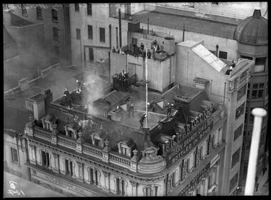
... fires...hotels...1930-1939...type=3 Fire Alarm Call Box, Wikipedia, https://en.wikipedia.org/wiki/Fire_alarm_call_box Research notes, 'A city lost and found', Robyn Annear, https://robynannear.com/docs/whelan-the-wrecker-notes.pdf fires hotels 1930-1939 Photographer notations on slide: "Fire at Cathedral Hotel Swanston St City March 1936 B104". ...Fire at the Cathedral Hotel! Bird’s eye view These firemen on the roof of the Cathedral Hotel are very bold in their approach to firefighting! One heroically aims a firehose at the roof while another holds onto the flagpole with one hand as he walks around the narrow edge, three storeys up! Onlookers from adjacent buildings make the most of their front row view, and The Age reported that on street level, hundreds of people gathered to watch, enthralled by “a thrilling spectacle when three firemen walked along the stone coping on the top floor of the building and, despite the clouds of smoke and sheets of flame which shot through the roof they ripped off the hot slate tiles and provided an outlet for the flames”. The Cathedral Hotel was built in 1883 and demolished in 1966 to make way for the City Square. Featured in "Newsworthy: Melbourne in photographs 1933-1936" exhibition at East Melbourne Library, October to December 2023. Exhibition caption by project volunteer, Louise McKenzie. Photographer notations on slide: "Fire at Cathedral Hotel Swanston St City March 1936 B104" Description: View looking down on roof of the Cathedral Hotel showing 16 firefighters battling a fire. There is smoke coming through the roof. Onlookers watch from adjoining buildings, not perturbed by the proximity of the fire. The firemen look bold and impressive in their brass helmets. Research by project volunteer, Louise McKenzie: The Age reported on 4 March 1936 that the fire broke out in rubbish between the roof space and wooden ceiling of the Cathedral Hotel at 4.30 pm. “The Eastern Hill fire brigade was notified by telephone, and an almost simultaneous call was also received at fire brigade headquarters from a street alarm.” These red fire alarm call boxes were typically installed on street corners, and when the knob was turned, a pulsed electric signal corresponding to the box’s number was received at fire headquarters. A large detachment of firemen with full fire-fighting equipment, including two large extension ladders, were quickly on the scene, pouring vast quantities of water into the hotel, causing several hundred pounds of damage to hotel and guest property, but quickly bringing the fire under control. Lengths of hose had to be carried through the front entrance and up several flights of stairs. On street level hundreds of people gathered to watch, but were controlled by police in order to keep them at a safe distance and ensure that tram and motor traffic was not seriously disorganised. The crowd were enthralled by “a thrilling spectacle when three firemen walked along the stone coping on the top floor of the building and, despite the clouds of smoke and sheets of flame which shot through the roof, they ripped off the hot slate tiles and provided an outlet for the flames”. The firemen are noteworthy for their highly polished brass helmets, known as Merryweather helmets, based on those of French sapeurs-pompiers and introduced to the British Metropolitan Fire Brigade in London in 1868. Metal helmets are conductive, a safety issue as the use of electricity became widespread, so a composite cork and rubber helmet was introduced in London from 1936. In Queensland, traditional brass helmets remained in service until 1970. The firemen are very bold in their actions – one heroically aiming a fire hose at the roof of the building, another holding onto the flagpole with one hand as he walks around the narrow top edge of the roof, three storeys up! The onlookers from adjoining buildings are interested in the spectacle, rather than dismayed by the fire. Lettering around the building exterior reads "Cathedral Hotel - Erected 1883". Prominent signage for “Richardson’s whisky, brandy, gin & rum" sits along the edge of the roof. The Cathedral Hotel was located on the corner of Swanston Street and Flinders Lane. It was built in 1883, and its name derived from St Paul’s Cathedral on the south side of Flinders Lane. It was demolished in 1966 as Melbourne City Council wished to create a City Square. Robyn Annear notes that at the time, the development was referred to as “Whelan’s Square” due to the large number of buildings which needed to be demolished to create the Square. Ironically the Hotel had been the victim of a previous fire in 1917, when its then licensee, also named Whelan, was charged with two failed arson attempts. References: No title (1936, March 4). The Age (Melbourne, Vic. : 1854 - 1954), p. 13. Retrieved February 5, 2024, from http://nla.gov.au/nla.news-article205256255 FIRE AT A CITY HOTEL. (1936, March 4). The Age (Melbourne, Vic. : 1854 - 1954), p. 12. Retrieved February 5, 2024, from http://nla.gov.au/nla.news-article205256231 FIRE IN ROOF OF CITY HOTEL (1936, March 4). The Argus (Melbourne, Vic. : 1848 - 1957), p. 8. Retrieved February 5, 2024, from http://nla.gov.au/nla.news-article11018696 Hotel Roof Fire Draws Crowd (1936, March 4). Examiner (Launceston, Tas. : 1900 - 1954), p. 8 (DAILY). Retrieved February 5, 2024, from http://nla.gov.au/nla.news-article52000751 'Flinders Lane Melbourne 1966', Peter Andrew Barrett, Facebook, 12 June 2020, https://www.facebook.com/120943481324886/photos/a.512123662206864/3025002490918956/?type=3 Fire Alarm Call Box, Wikipedia, https://en.wikipedia.org/wiki/Fire_alarm_call_box Research notes, 'A city lost and found', Robyn Annear, https://robynannear.com/docs/whelan-the-wrecker-notes.pdfPhotographer notations on slide: "Fire at Cathedral Hotel Swanston St City March 1936 B104".fires, hotels, 1930-1939 -
 Clunes Museum
Photograph
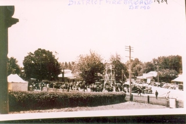
... SEPIA PHOTOGRAPH OF FIRE BRIGADE DEMONSTRATION IN CLUNES 1939 ....DISTRICT FIRE BRIGADE DEMO 1939...Clunes Museum 36 Fraser Street enter building through Collins Place Clunes goldfields local history photography photographs fire brigade DISTRICT FIRE BRIGADE DEMO 1939 SEPIA PHOTOGRAPH OF FIRE BRIGADE DEMONSTRATION IN CLUNES 1939 . ...SEPIA PHOTOGRAPH OF FIRE BRIGADE DEMONSTRATION IN CLUNES 1939 .DISTRICT FIRE BRIGADE DEMO 1939local history, photography, photographs, fire brigade -
Bendigo Historical Society Inc.
Document - Forests Commission of Victoria Northern Area Fire Protection Policy, Statement, Future Bush Fire Policy, Plan for Fire Control, 1938-1939
... ...1939 Bush Fires...Fanned by powerful winds, the Black Friday fires (13 January 1939) swept rapidly across large areas of Victoria, causing widespread destruction. ...Four Files Forests Commission of Victoria Northern Area Report on the 1938-39 Fire Season; and the Fire Protection Policy in Respect of Field activities Prior to the Incidence of the 1939 Fires. ...History House 11 Mackenzie Street Bendigo goldfields Fanned by powerful winds, the Black Friday fires (13 January 1939) swept rapidly across large areas of Victoria, causing widespread destruction. ...Fanned by powerful winds, the Black Friday fires (13 January 1939) swept rapidly across large areas of Victoria, causing widespread destruction. Flames leaped large distances, and giant trees were blown out of the ground by fierce winds. Large pieces of burning bark (embers) were carried for kilometres, starting new fires in places that had not previously been affected by flames. Almost two million hectares burned across the state. Large areas of state forest, containing giant stands of Mountain Ash and other valuable timbers, were destroyed. As a result, approximately 575,000 hectares of reserved forest and 780,000 hectares of Crown land burned.Four Files Forests Commission of Victoria Northern Area Report on the 1938-39 Fire Season; and the Fire Protection Policy in Respect of Field activities Prior to the Incidence of the 1939 Fires. history, bendigo, forests commision of victoria, 1939 bush fires -
 Stawell Historical Society Inc
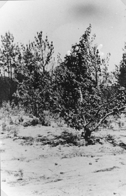
Photograph, Bushfire Damage at the Apple tree orchard at Pomonal 1939
... Apple tree orchard after 1939 Fires at Pomonal...Stawell Historical Society Inc 46 Longfield St Stawell grampians Apple tree orchard after 1939 Fires at Pomonal stawell Black and white photo of what looks to be an orchard as fruit on the ground. ...Apple tree orchard after 1939 Fires at PomonalBlack and white photo of what looks to be an orchard as fruit on the ground.stawell -
 Kiewa Valley Historical Society
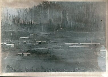
Photograph - Bogong Village (7 copies), Approx 1940
... Set of 7 identical black and white photographs of Bogong Village after 1939 bush fires...Handwritten on the back of one photo - Bogong Village approx. 1940, after 1939 bush fires. Staff residences to left. Kiewa House, General offices and test lab to the right. ...Set of 7 identical black and white photographs of Bogong Village after 1939 bush fires Photograph - Bogong Village (7 copies) ...In 1940 Field Headquarters for the Kiewa Scheme were established at Bogong with office, workshop facilities and accommodation for workmen, staff and some families constructed. (There had been a 'tent camp' on this site in 1939 but was destroyed by bushfires) Construction of accommodation continued until 1947. A total of 40 houses plus a hostel for single staff, post office, police station, medical centre and primary school all with water and sewerage and electricity supply. The staff hostel was known as Kiewa House and is now occupied by the Education Department. Lake Guy was named after Mr. L.T. Guy who was the Resident Engineer in charge of construction work and associated activities on the Kiewa area. He held this position from 1939 to November 1946 when he was transferred to Head Office. The Bogong Township was developed firstly as an accommodation centre (base camp) for construction workers employed under the Kiewa Hydroelectric Scheme. Due to the influx of European workers into the Township the beautification of the immediate surrounds (gardens etc.) had a distinct European flavour. This environment has been very beneficial for tourism in later years. At the completion of the scheme, in the 1960's, the village was opened to public/tourism use. Strict environmental control has not allowed for any extensive redevelopment in tourist accommodation and basically restricted it to the accommodation initially built for the construction workers. Activities such a bike riding, snow skiing, restricted horse riding and bush walking on the Alpine plains and mountains are now a viable part of the Kiewa Valley Tourist Industry. The lake is one of the many water storage reservoirs used to supply the power stations their main power to run the huge turbines generating the final product, electricity. Evidence can be seen of the 1939 bushfires.Set of 7 identical black and white photographs of Bogong Village after 1939 bush firesHandwritten on the back of one photo - Bogong Village approx. 1940, after 1939 bush fires. Staff residences to left. Kiewa House, General offices and test lab to the right. Hand drawn map on the back of one photo.bogong village, secv -
 Stawell Historical Society Inc
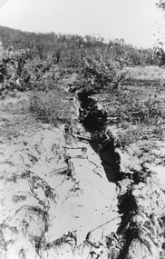
Photograph, Bushfire damage showing Soil Erosion 1939
... The erosion has resulted from the 1939 bush fire....The erosion has resulted from the 1939 bush fire. Bushfire damage showing Soil Erosion 1939 Photograph ...Scene showing soil erosion after 1939 bushfire. Black and white photograph of a ravine down the side of a hill. The erosion has resulted from the 1939 bush fire.stawell -
 Linton and District Historical Society Inc
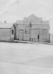
Photograph, Old Linton Fire Station, circa 1930
... Linton fire station pre 1939 - at LHS is the Linton weighbridge used until the 1930s. ...Linton and District Historical Society Inc 69 Sussex Street Linton 3360 goldfields Linton fire station pre 1939 - at LHS is the Linton weighbridge used until the 1930s. ...Linton fire station pre 1939 - at LHS is the Linton weighbridge used until the 1930s. The lamp on the fire station was powered by gas.Small black and white photograph of wooden building, with small hut on LHS, gas lamp in centre and large expanse of road in front."Front of the old/ fire brigade at/ Linton/ Linton weigh bridge".linton weighbridge, linton fire station -
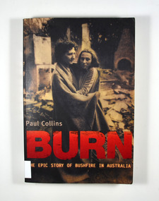 Marysville & District Historical Society
Book, Paul Collins, Burn-The Epic Story of Bushfire in Australia, 2006
... From the 1851 Black Thursday fire and the 1939 Black Friday fires to the Canberra inferno of 2003 this book tells the epic story of bushfire in Australia....Marysville & District Historical Society 39 Darwin Street Marysville yarra-valley-and-the-dandenong-ranges From the 1851 Black Thursday fire and the 1939 Black Friday fires to the Canberra inferno of 2003 this book tells the epic story of bushfire in Australia. forest fires bush fires australia history The story of bushfires in Australia Stamp of Marysville & District / Historical Society Inc / P.O. ...The story of bushfires in AustraliaFront cover has a photograph of Sharon Guest and her daughter Patricia in the ruins of their Mt Macedon home, Ash Wednesday.non-fictionThe story of bushfires in Australiaforest fires, bush fires, australia, history -
Moorabbin Air Museum
Document (Item) - Ansett Transport Industries Ltd Company History
... Includes a range of subjects as listed below, The Hangar Fire ..... 1939 Ansett Airways' War Years Pioneer Country Dealership And Road Services Ansett Hotels The Two-Airliner And The Ansett Purchase Of A.N.A The First Road Services 'Going Public" And The First Financial Crisis MacRobertson Miller Airline Services A History Of Aviation Spanning 56 Years Wridgways Ansett General Aviation Television Developments Austarama Television Pty Ltd And Universal Telecasters Qld Ltd The Rose Fight Thomas Nationwide Transport Ltd Take-Over Bid For Ansett Transport Industries Ltd The First Air Services Ansett Airways Ltd The Butler Take-Over ATI Associated Companies Other ATI Subsidiaries The Air Race ...... 1936 Ansair Pty Ltd ...Moorabbin Air Museum Moorabbin Airport 12 First Street Moorabbin melbourne Includes a range of subjects as listed below, The Hangar Fire ..... 1939 Ansett Airways' War Years Pioneer Country Dealership And Road Services Ansett Hotels The Two-Airliner And The Ansett Purchase Of A.N.A The First Road Services 'Going Public" And The First Financial Crisis MacRobertson Miller Airline Services A History Of Aviation Spanning 56 Years Wridgways Ansett General Aviation Television Developments Austarama Television Pty Ltd And Universal Telecasters Qld Ltd The Rose Fight Thomas Nationwide Transport Ltd Take-Over Bid For Ansett Transport Industries Ltd The First Air Services Ansett Airways Ltd The Butler Take-Over ATI Associated Companies Other ATI Subsidiaries The Air Race ...... 1936 Ansair Pty Ltd Ansett Transport Industries Ltd Company History Document Ansett Transport Industries Ltd Company History ...Includes a range of subjects as listed below, The Hangar Fire ..... 1939 Ansett Airways' War Years Pioneer Country Dealership And Road Services Ansett Hotels The Two-Airliner And The Ansett Purchase Of A.N.A The First Road Services 'Going Public" And The First Financial Crisis MacRobertson Miller Airline Services A History Of Aviation Spanning 56 Years Wridgways Ansett General Aviation Television Developments Austarama Television Pty Ltd And Universal Telecasters Qld Ltd The Rose Fight Thomas Nationwide Transport Ltd Take-Over Bid For Ansett Transport Industries Ltd The First Air Services Ansett Airways Ltd The Butler Take-Over ATI Associated Companies Other ATI Subsidiaries The Air Race ...... 1936 Ansair Pty Ltd -
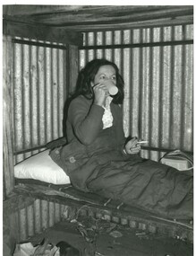 Falls Creek Historical Society
Photograph - Joan Meyer at Diamantina Hut, c1968
... It was rebuilt in about 1968 as the original hut was burnt down in the 1939 fires....It was rebuilt in about 1968 as the original hut was burnt down in the 1939 fires. Joan Meyer at Diamantina Hut Photograph Joan Meyer at Diamantina Hut ...MEYER COLLECTION - FALLS CREEK PHOTOS In 1947 a determined group of like-minded State Electricity Commission (SEC) staff including Ray Meyer, the chief surveyor of the Kiewa Hydro-Electric Scheme, had a common interest that revolved around the skiing potential of the snow-covered high plains which included what is now the resort of Falls Creek. The six SEC employees, Toni St Elmo, Ray Meyer, Jack Minogue, Lloyd Dunn, Adrian Ruffenacht and Dave Gibson (together with their families) banded together to secretly build a 'hut' that was the first ski lodge at Falls Creek. Using a road built in 1930s to gain access to Falls Creek, their hut project was carried out in secret as efforts by other skiers were blocked by H.H.C. Williams – the engineer in charge of the Hydro Scheme. In 1946 Ray Meyer made a trip to the Lands Office in Melbourne. He came away with a 99-year lease on three acres that was ideally suited for a hut designed by Lloyd Dunn. Adrian Ruffenacht (Design Engineer for the KHS) had suggested where the group should build because of easy access to a spring for water. Much of the building material required was scavenged from derelict huts on the high plains. Due to the need for secrecy, the determined group worked on the hut in the evenings and weekends to avoid detection. During the building period the group had met at Echidna Rock (now known as Eagle Rock) where Skippy St Elmo announced, "This is my favourite ‘Skyline’.” And so the first lodge in the area at Falls Creek Ski Resort came into existence. With the development of the International Poma in the 1970s, the Skyline Lodge, which was sited between the ski-lift’s pole one and pole two, was demolished. However, the legacy of Ray Meyer, Toni St Elmo, Jack Minogue, Lloyd Dunn, Adrian Ruffenacht and Dave Gibson and Skyline lives on in the vibrant atmosphere of Falls Creek Resort. The MEYER COLLECTION documents developments on the Kiewa Hydro Scheme and their life at Falls Creek from the mid 1930s to 1960s.This image is significant because it depicts a member of a pioneering family of Falls Creek area, and one of the founders of Skyline Lodge.A black and white image of Joan Meyer in Diamantina Hut. The hut on Mt Hotham, was built originally as a Country Roads Board workers hut in the early 1920s to shelter workers who were building and maintaining the Great Alpine Rd. It was rebuilt in about 1968 as the original hut was burnt down in the 1939 fires.falls creek, victorian snowfields, joan meyer, diamantina hut -
 Orbost & District Historical Society
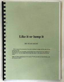
book, Like It Or Lump It, 2001
... It was written by Stan Hunt and tells of his and his family's experience of the 1939 fire in which he was caught as a child as well as the sugar beet industry in Maffra where he worked at as a teenager. ...It was written by Stan Hunt and tells of his and his family's experience of the 1939 fire in which he was caught as a child as well as the sugar beet industry in Maffra where he worked at as a teenager. ...Originally written for children and family between 1998-2000. This book of memoirs provides a personal insight to the history of Maffra in the first half of the 20th century.A 296 pp spiral bound book with a green cover titled Like It Or lump It. It was written by Stan Hunt and tells of his and his family's experience of the 1939 fire in which he was caught as a child as well as the sugar beet industry in Maffra where he worked at as a teenager. The author describes carting the beet and working in the factory where they processed the beet.Inside front cover - autographed by Stan Huntmaffra-history-memoirs hunt-stan -
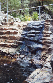 Lakes Entrance Historical Society
Photograph - Costick's Weir Nowa Nowa 1999
... Built 1942 - 43 to ensure as adequate water supply for fire fighting purposes, after the devastation of the 1939 forest fires. ...Built 1942 - 43 to ensure as adequate water supply for fire fighting purposes, after the devastation of the 1939 forest fires. ...Built 1942 - 43 to ensure as adequate water supply for fire fighting purposes, after the devastation of the 1939 forest fires. Used by locals as a swimming pool until flooding in the 1980's filled the weir with silt.Two Colour photograph of Costicks Weir, Old Colquhoun Road, Colquhoun Forest. Shows manmade dam in bush setting. Constructed by building a weir wall across a small natural gorge. Nowa Nowa Victoriavegetation, weir's, local history -
 Kiewa Valley Historical Society
Photographs and copies of photographs of the pack horses and early horsemen who transported supplies to outposts in the Bogong High Plains, via cattle tracks before access roads were made
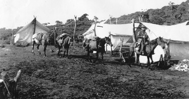
... The tent city at Bogong was destroyed by bush fires in 1939 after which an access road was built from Mt Beauty to transport building materials for more permanent dwellings for workmen. ...The tent city at Bogong was destroyed by bush fires in 1939 after which an access road was built from Mt Beauty to transport building materials for more permanent dwellings for workmen. ...In the mid to late 1930’s survey outposts were established to plot the early stages of the Kiewa Hydro Electric System for the SECV in the Bogong High Plains. Before any roads were built, the old cattleman’s tracks were used with packhorses to deliver supplies, wages and mail and collect timesheets and correspondence from the workmen and dam builders living in canvas tents and at the outlying survey posts. The trip up the mountain was long and hard and dangerous for both horse and man Most of the men of the survey teams were not bush-men and were often ill equipped for the harsh weather and living conditions of bush camping, often arriving in their city clothes ready for work. The tent city at Bogong was destroyed by bush fires in 1939 after which an access road was built from Mt Beauty to transport building materials for more permanent dwellings for workmen. Pack horses continued to be used for transporting goods etc. to workers further up the mountain.Without the work of horsemen and their pack horses providing supplies and communications for outlying outposts, surveying and early planning for the Kiewa Valley Hydro Electric scheme could not have gone ahead and the dams and power stations which support the system could not have been constructed. The Hydro-electric scheme, and the workers who planned and built it play a major part in the early history of the Kiewa Valley and many original families still remain living, or have ties with the local area.: Set of 21 black and white photographs and copies of photographs depicting the pack horses and the men who handled them, transporting supplies and correspondence to the outlying camps and survey posts in the Bogong High Plains, via the rough cattlemen’s tracks. Photographs also show the early tent camps of the workers. Some photos mounted on A4 white paper. Some photos enlarged to A3 poster size for display1. Handwritten on back – Max Lawrence 2. -8 No inscriptions 9. Handwritten on back- Packing in supplies for early workers of the Kiewa Hydro scheme. There were no roads in the early days of the scheme 10. Printed on bottom of photo- Roper’s cattle on road below Howman’s Gap 11. Handwritten on back – Roper’s et al about to leave for the high plains 12. Printed under photo- Syd Ryder at the Pretty Valley Cut-Out (JBR) 13-16. No markings 17. Printed under photo- Gwen Talbot visits the Camp area. 1937 18. Handwritten on back- 14/1 Barbara Talbot 19. No markings 20-21. No markings 22. Printed under photo- STATE ELECTRICITY COMMISSION OF VICTORIA. Date: 15-3-45 Time: 8.0pm No: K 1838 Kiewa Hydro-Electric Works, Investigations 1944-1945 – Survey Camp at Young’s Hut pack horses; bogong high plains; survey posts; supplies delivery -
 Falls Creek Historical Society
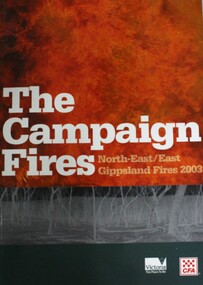
Book - The Campaign Fires - North-East/East Gippsland Fires 2003, Lyndel Hunter
... Eight of these fires were unable to be contained; they joined together to form the largest fire in Victoria since the Black Friday fires in 1939. The majority of the area burnt in Victoria was public land, 1.19 million hectares of parks and forests, including 60 per cent of the Alpine National Park and 81 per cent of the Mt Buffalo National Park. ...Eight of these fires were unable to be contained; they joined together to form the largest fire in Victoria since the Black Friday fires in 1939. The majority of the area burnt in Victoria was public land, 1.19 million hectares of parks and forests, including 60 per cent of the Alpine National Park and 81 per cent of the Mt Buffalo National Park. ...A description of efforts to fight the bushfires in Gippsland in 2003, including maps and illustrations. This volume was published as a tribute to the work of staff and volunteers who put themselves at risk to protect local communities. It shows the impact on those communities in Victoria and the support they gave to those involved in fighting largest bushfires in Victoria for 60 years. The Alpine bushfires started on 8th January 2003, a day of Total Fire Ban. Lightning ignited 87 fires in the North-East and East Gippsland regions. Eight of these fires were unable to be contained; they joined together to form the largest fire in Victoria since the Black Friday fires in 1939. The majority of the area burnt in Victoria was public land, 1.19 million hectares of parks and forests, including 60 per cent of the Alpine National Park and 81 per cent of the Mt Buffalo National Park. Firefighting efforts were made difficult in hard-to-access, remote forest terrain. Approximately 90,000 hectares of private land was burnt.This book is significant because it documents the 2003 Victorian Bushfires and serves as a tribute to the CFA staff and volunteers who fought them.This publication of 119 pages features text, colour images, maps and detailed information related to the 2003 bushfires in Victoria.At bottom of front cover:- CFA Victoria Logo Victorian Government Logovictorian fires 2003, cfa (vic) -
 Stawell Historical Society Inc
Photograph, Saw Mills at Childe’s Glenbower Creek in Halls Gap 1866
... Wherever there are large tracts of natural bushland, fires are always a danger. A huge fire in January 1939 caused havoc in the Grampians, burning out towns and sawmills such as the one pictured. ...Wherever there are large tracts of natural bushland, fires are always a danger. A huge fire in January 1939 caused havoc in the Grampians, burning out towns and sawmills such as the one pictured. ...Saw Mills Halls Gap (Childe’s Glenbower Creek). Part of a collection of Photographs by Mr. O.G. Armstrong as commissioned by the Shire of Stawell for the Inter-colonial and Paris Exhibition in Melbourne in 1866. During the years of gold, the hardwood forests around Stawell were ravaged to provide timber for the mines. It was used undergrounds to shore up workings, and millions of feet of it were fed into furnaces and kilns in which the quartz was roasted. In the years after the gold boom, hardwood from the Grampians was milled for building timber. Wherever there are large tracts of natural bushland, fires are always a danger. A huge fire in January 1939 caused havoc in the Grampians, burning out towns and sawmills such as the one pictured. There have been no sawmills in the Grampian since that fire. stawell industry -
 Kiewa Valley Historical Society
Photographs – Set of 10 black and white photographs and photocopies of original photographs documenting early residents of Bogong Village
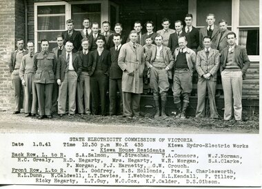
... The road to Bogong had reached the lookout spur just beyond Roper’s Spur track just before the 1939 fires. The early forties saw rapid growth of the village, with single and married men’s quarters, workshops, mess huts and administrative offices. ...The road to Bogong had reached the lookout spur just beyond Roper’s Spur track just before the 1939 fires. The early forties saw rapid growth of the village, with single and married men’s quarters, workshops, mess huts and administrative offices. ...Bogong Village, which was known as “The Junction”, is well recorded. The first tent camp was at the junction of Pretty Valley and Rocky Valley streams in the early 40’s. Further downstream were the sawmill, stables and blacksmith’s forge. Horses were the main mode of transport in the early days. The road to Bogong had reached the lookout spur just beyond Roper’s Spur track just before the 1939 fires. The early forties saw rapid growth of the village, with single and married men’s quarters, workshops, mess huts and administrative offices. The facilities necessary for communal living were quickly in place- a post office, police station, co-op store, medical centre, community hall/theatre, tennis courts and school. Much of the temporary accommodation that housed groups such as the Albion Quarrying Company were in the area now under water.This group of photographs are a pictorial record of the early history of the Kiewa Hydro Scheme, the people who worked in the background supplying administrative support and the workers and their families. It also shows a glimpse into how a large group of people from very diverse backgrounds came together to enjoy social activities and share each others companyGroup of 10 black and white photographs and photocopies of original photographs of varying sizes (some official SECV photos) Some Photos are labelled with the date and the names of SECV staff members. Depicting early life at Bogong Village 1. Group photo – Kiewa House Residents 1.8.41 (SECV official photo) 2. Female staff residents 3. Female office staff 4. Kitchen staff – Junction Mess (SECV official photo) 5. Male administration staff Bogong 6. Bogong Social Club fancy dress ball, 1940 7. Wives and children of SECV workers 8. Children in fancy dress 9. Opening of Volunteer Air Observers post 1943 10. Flag raising at opening of Volunteer Air Observers post 1. Printed under photo: STATE ELECTRICITY COMMISSION OF VICTORIA Date: 1.8.41 Time: 12.30pm No:K 435 Kiewa Hydro-Electric Works. Kiewa House Residents Back Row L to R: S.A. Salmon, W. Strachn, T.A Connors, W.J Norman, R.C Grealey, R.D Hegarty, Mrs Hegarty, W.R Morgan, S.A Clarke, P. Morgan, P.J. Harnetty, G.W Crouch. Front Row L to R: W.L Godfrey, R.S Hollands, Pte. R Charlesworth, R.L Dunn, N Caldwell, L.T Davies, I Webber, H.L Kendall, P Tiller, Ricky Hegarty, L.T Guy, M.C Cox, K.F Calder, D.S Gibson 2. Printed on bottom: Staff who lived at Kiewa House and worked in the Administration Office c 1943 Handwritten at bottom Priscilla Johnson (nee Reid) At top of page A GOOD LIFE: WOMEN’S RECOLLECTIONS OF LIFE IN THE UPPER KIEWA VALLEY 3. Printed under photo- Office Staff – Bogong 4. Printed under photo: STATE ELECTRICITY COMMISSION OF VICTORIA Date: 18.5.40 Time: 11.05am No:K 103. Kiewa Hydro-Electric Works. Kitchen Staff- Junction Mess. Opening night of the new staff mess Bogong. 5. Printed under photo -Administration staff Bogong 6. Printed under photo- The social club raised money for patriotic fund from fancy dress nights. (1st Fancy Dress Ball, Bogong 1940) 7. Printed above photo: ---- and family life begins (1942 Bogong) 8. Printed under photo: A favourite photograph 9. Printed under photo: STATE ELECTRICITY COMMISSION OF VICTORIA Date: 24.5.43 Time: 2.8pm No:K 1151 Kiewa Hydro-Electric Works. Bogong- Squadron Leader Leggett speaking at opening of Air Observer’s Post 10. Printed under photo: Raising the flag at the opening of the Volunteer Air Observer’s Post at Bogong - 1943 bogong village; kiewa hydro electric scheme; social activities; community clubs -
 Sunshine and District Historical Society Incorporated
Archive - Saint Teresa's (St. Theresa's) Adelaide Street Albion
... Donchi|Photo Old church after 1939 fire|Photo Old Our Ladies Hall|Photo St. ...Donchi|Photo Old church after 1939 fire|Photo Old Our Ladies Hall|Photo St. ...Saint Teresa's (St. Theresa's) Boundaries|Archbishop D. Mannix|Parish Priest Rev. Fr. Murply, Rev. Fr. Walsh|President A. J. Strachan|Team's Chairman L. Donchi|Photo Old church after 1939 fire|Photo Old Our Ladies Hall|Photo St. Teresa's during construction|Photo Parish Hall Committe 1926 T. Fox, M. Martin, J. Donovan Rev. J. P. Carney, P. Cannon, Mr. Maher & Mr. M. Laffan|Photo St. Teresa's at completion|The History Of oue Parish|Photo Fr. Francis Ryder|Photo Fr. James Egan|Photo School Childrenst. theresa's church, church, adelaide street, albion -
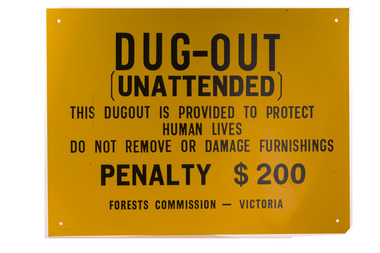 Department of Energy, Environment and Climate Action
Dugout sign, Post 1966
... Dugouts became mandatory for those few sawmills that remained in the forest after the 1939 fires. Many remote logging coupes and FCV roading camps also had dugouts. ...Dugouts became mandatory for those few sawmills that remained in the forest after the 1939 fires. Many remote logging coupes and FCV roading camps also had dugouts. ...Considered in terms of both loss of property and loss of life, the Black Friday bushfires on 13 January 1939 were one of the worst disasters to have occurred in Australia and certainly the worst bushfire up to that time. The fires burnt 2 million hectares, 69 sawmills were destroyed, 71 people died, and several towns and sawmills were entirely obliterated. Among those killed were four men from the Commission The subsequent Royal Commission conducted by Judge Leonard Stretton has been described as one of the most significant inquiries in the history of Victorian public administration. Its recommendations led to sweeping changes. In addition to building dams and water points, the Stretton Royal Commission recommended expanding and controlling the use of bushfire dugouts at forest sawmills. Well-constructed dugouts had saved the lives of many sawmill workers and their families during the 1939 bushfires. But in some locations, they had proved fatal. Dugouts became mandatory for those few sawmills that remained in the forest after the 1939 fires. Many remote logging coupes and FCV roading camps also had dugouts. The local District Forester was required to make annual pre-season inspections of all dugouts on State forests and those within the Fire Protected Area (FPA). Some were built privately on private land. Most were primitive construction with a log or corrugated iron roof covered with earth. A hessian bag often hung at the entrance to keep the heat and smoke out. But they were dark and damp with snakes and other creepy crawlies often lurking inside. By 1940-41 there were 19 new dugouts constructed by the Commission and a further 128 by forest licensees. Ten years later there were 8 new Commission dugouts and 21 new ones built by other interests. By 1960-61 the rate of new builds was declining but the Commission still managed 103 dugouts while 127 were looked after by others. However, as the forest road network improved and gave all-weather access to modern two-wheel-drive vehicles the reliance on dugouts receded.Large metal sign that was positioned near forest dugoutsbushfire, forest signs, forests commission victoria (fcv) -
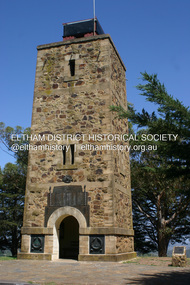 Eltham District Historical Society Inc
Photograph - Digital Photograph, Alan King, Shire of Eltham War Memorial, Kangaroo Ground, 28 January 2008
... It was suggested that if the Shire were to appoint a caretaker for the Memorial Park, his duties could also include raising the alarm in the event of a fire. Later in 1939 Council applied for a radio transmitter, which the Forestry Commission planned to install at vantage places throughout the state. ...It was suggested that if the Shire were to appoint a caretaker for the Memorial Park, his duties could also include raising the alarm in the event of a fire. Later in 1939 Council applied for a radio transmitter, which the Forestry Commission planned to install at vantage places throughout the state. ...The Eltham Shire War Memorial, a tower of remembrance, was built with public donations to commemorate the memory of the fallen soldiers from the shire who enlisted in the 1914-1918 war. The tower is reminiscent of the peel-towers or watchtowers that lined the English-Scottish border from the mid 14th century to around 1600 and is constructed from locally quarried stone. This uncommon and picturesque war memorial, which affords an excellent view of the surrounding district was unveiled by His Excellency the Governor-General (Lord Stonehaven) on November 11, 1926. In July 1922 a deputation of returned soldiers from Panton Hill, presumably the Panton Hill branch of the Returned Sailors and Soldiers Imperial League of Australia (RSSILA), proposed to Eltham Shire Council that the monument should be a cairn of local stone “sufficiently high to form a prominent and conspicuous landmark, and crowned with some suitable device”. Eltham Shire Councillor and President of the Panton Hill branch of the RSSILA, Basil Hall, was credited with being the first to suggest a tower, and with organising a Memorial Park committee to raise funds for the monument in the Memorial Park. A meeting for those interested in the establishing a War Memorial monument in the park was held in January 1924 and the Eltham Shire War Memorial League was formed for this purpose. It appears that the broad and rounded cairn that had been recently built was considered by the League a temporary affair, and not the substantial cairn-as-monument, sufficiently high to form the conspicuous landmark, which had been envisaged by the Panton Hill RSSILA. A design competition was held for the monument. The chairman of the League, Councillor Basil Hall, suggested that the site of the memorial in Kangaroo Ground would lend itself to something rugged, instead of polished stone. By April 1924 thirty designs for a memorial had been received from which three designs were selected and of those, the design by the shire engineer Mr McCormack, for a 70ft tower suitable for construction in rough stone, was chosen. Artist Harold Herbert suggested that a peel tower-like design reminiscent of those along the English-Scottish border would be fitting for the site. Herbert drew up a rough sketch that was approved of, and later, Melbourne architect Percy Meldrum volunteered to draw up the design from sketch to architectural drawings. By January 1925 the Soldiers’ Memorial League had adopted Meldrum’s design for a 50ft high tower. Meldrum had also offered his design and supervision of construction free of charge. The Shire provided the stone to the builders, which was a gift quarried from land owned at Kangaroo Ground by Dr Ethel and Professor William Osborne The Shire of Eltham War Memorial, a tower of remembrance, and honour board were unveiled on November 11, 1926, by the Governor General Lord Stonehaven. At this stage a temporary honour roll was painted on the panels on either side of the tower entrance. In September 1930 bronze plates were added above the portal with the names of men who fell in the 1914-18 war. On November 16, 1951, the Governor of Victoria, Sir Dallas Brooks re-dedicated the war memorial tower and unveiled the names of men who gave their lives in the 1939-45 war. Two additional bronze plaques which recognise service in the armed conflicts of Korea, Borneo, Malaya, and Vietnam were unveiled November 11, 2001, by the Governor of Victoria, John Landy, A.C., M.B.E. The tower was first used for fire spotting activities following the Black Friday bushfire in January 1939 in response to a request from Mr R.D. Ness, secretary of the Kangaroo Ground bush fire brigade, who asked Council that the tower be used as an observation tower for detecting bush fires, and asked Council to arrange a telephone to be installed. It was suggested that if the Shire were to appoint a caretaker for the Memorial Park, his duties could also include raising the alarm in the event of a fire. Later in 1939 Council applied for a radio transmitter, which the Forestry Commission planned to install at vantage places throughout the state. The first dedicated fire spotter appointed from December1948, was Mr Smith of Warrandyte. A prefabricated glazed cabin was installed in 1974, which involved the removal of the original stone structure around the rooftop exit door. A new fire spotting cabin, which included the latest technology, was installed soon after the 2009 Black Saturday fires and is manned by CFA personnel on high fire danger days. Covered under Heritage Overlay, Nillumbik Planning Scheme. Published: Nillumbik Now and Then / Marguerite Marshall 2008; photographs Alan King with Marguerite Marshall.; p123This collection of almost 130 photos about places and people within the Shire of Nillumbik, an urban and rural municipality in Melbourne's north, contributes to an understanding of the history of the Shire. Published in 2008 immediately prior to the Black Saturday bushfires of February 7, 2009, it documents sites that were impacted, and in some cases destroyed by the fires. It includes photographs taken especially for the publication, creating a unique time capsule representing the Shire in the early 21st century. It remains the most recent comprehenesive publication devoted to the Shire's history connecting local residents to the past. While published in the book in black and white, this collection features the original colour digital photographs. nillumbik now and then (marshall-king) collection, garden hill, kangaroo ground, memorial park, shire of eltham war memorial -
Federation University Historical Collection
Document, Zelda Martin, Central Victorian Goldmining towns - Boom Towns or Ghost Towns?, c1996
... *Three articles published by Buninyong and District Historical Society Inc: (Magpie Exploration; Finding Gold In The Green Hills; Magpie Exploration; Burnt Bridge to Cargarie to Mt Mercer) *Copies of newspaper articles/items *Buninyong Street Directory Carisbrook: *In the Beginning There Was Carisbrook *The History of the Carisbrook Racecourse Carngham / Snake Valley: *Brief History *Directory Castlemaine: *Directory 1865-1866 - Alphabetical and Street *Poster - Castlemaine A Contemporary Guide "The Great Centre" 1866 - A Contemporary Guide to the Fascinating Past *Pamphlet - Castlemaine District Community Hospital *Map - Castlemaine, Maldon & Surrounding Districts *Map and Information - The Dry Diggings Track - a 55kl walk among historic goldfields relics ( Castlemaine Fryerstown Vaughan Mt Franklin Hepburn Daylesford) *Postcard - Former Court House *Directory 1867 - Alphabetical, Trade [.10] Resource No.3 Grey folder Titled Towns 3 Creswick to Maryborough Creswick: *Brief History *Booklet - "Creswick Cemetery Walk" *Booklet - The Buried Rivers of Gold Heritage Trail Creswick *Creswick Historical Museum Information Sheet *Chronological History of Creswick *Alphabetical Directory of the Borough of Creswick *Creswick's Creek Directory 1856 *Historic Creswick Walking Tour *A Brief Account of the Schools of Creswick - Past and Present *100 Years of Railway Travel in Creswick *The Berry Deep Leads *The Spence Home at Jackass Gully in the Creswick State Forest ( William Guthrie Spence - Pioneer) *The New Australian Mine and the 1882 Disaster *Creswick District News, Issue 7, July August 1999 *The Creswick Miners Walk - Information and Map *Maps Chewton: *Brief History *Directory Clunes: *Brief History *Clunes Street Directory Daylesford: *Brief History *Notable Bushfires in Daylesford District Over More Than a Century - "Black Thursday" 1851; 1862; 1899; the Disastrous Hepburn Fire of 1906; 1939; 1944; 1969. *Post Office Directory -Daylesford and Hepburn Dunolly / Inkerman: *Brief History *Directory *Pamphlet - Goldfields Historical Museum *Pamphlet - Historic Dunolly - Victoria's Best Kept Secret *Map of Gold Workings at Dunolly Area - showing where the main gold rushes occurred *Brief History - Inglewood *Directory - Inglewood - Name Occupation, Dwelling Kingower: *Brief History *Directory - Name / Ocupation / Dwelling Linton / Happy Valley / Piggoreet: *Brief History *Directory - Lintons McIvor: *"A History of the Shire and the Township of Heathcote" by J.O. ...*Three articles published by Buninyong and District Historical Society Inc: (Magpie Exploration; Finding Gold In The Green Hills; Magpie Exploration; Burnt Bridge to Cargarie to Mt Mercer) *Copies of newspaper articles/items *Buninyong Street Directory Carisbrook: *In the Beginning There Was Carisbrook *The History of the Carisbrook Racecourse Carngham / Snake Valley: *Brief History *Directory Castlemaine: *Directory 1865-1866 - Alphabetical and Street *Poster - Castlemaine A Contemporary Guide "The Great Centre" 1866 - A Contemporary Guide to the Fascinating Past *Pamphlet - Castlemaine District Community Hospital *Map - Castlemaine, Maldon & Surrounding Districts *Map and Information - The Dry Diggings Track - a 55kl walk among historic goldfields relics ( Castlemaine Fryerstown Vaughan Mt Franklin Hepburn Daylesford) *Postcard - Former Court House *Directory 1867 - Alphabetical, Trade [.10] Resource No.3 Grey folder Titled Towns 3 Creswick to Maryborough Creswick: *Brief History *Booklet - "Creswick Cemetery Walk" *Booklet - The Buried Rivers of Gold Heritage Trail Creswick *Creswick Historical Museum Information Sheet *Chronological History of Creswick *Alphabetical Directory of the Borough of Creswick *Creswick's Creek Directory 1856 *Historic Creswick Walking Tour *A Brief Account of the Schools of Creswick - Past and Present *100 Years of Railway Travel in Creswick *The Berry Deep Leads *The Spence Home at Jackass Gully in the Creswick State Forest ( William Guthrie Spence - Pioneer) *The New Australian Mine and the 1882 Disaster *Creswick District News, Issue 7, July August 1999 *The Creswick Miners Walk - Information and Map *Maps Chewton: *Brief History *Directory Clunes: *Brief History *Clunes Street Directory Daylesford: *Brief History *Notable Bushfires in Daylesford District Over More Than a Century - "Black Thursday" 1851; 1862; 1899; the Disastrous Hepburn Fire of 1906; 1939; 1944; 1969. *Post Office Directory -Daylesford and Hepburn Dunolly / Inkerman: *Brief History *Directory *Pamphlet - Goldfields Historical Museum *Pamphlet - Historic Dunolly - Victoria's Best Kept Secret *Map of Gold Workings at Dunolly Area - showing where the main gold rushes occurred *Brief History - Inglewood *Directory - Inglewood - Name Occupation, Dwelling Kingower: *Brief History *Directory - Name / Ocupation / Dwelling Linton / Happy Valley / Piggoreet: *Brief History *Directory - Lintons McIvor: *"A History of the Shire and the Township of Heathcote" by J.O. ...Zelda Martin was a PhD candidate at the University of Melbourne.[.1] 4th item in light blue display book titled Research Approach/Overview of Chapters/Confirmation of Canditure/Chapters1,2,3&4 of proposed thesis. *Twenty-seven page article on Victorian goldfields towns titled: Central Victorian Goldmining Towns - Boom Towns or Ghost Towns. The article was written during the author's PhD study. It outlines the context methodology, and resources and the chapters of the proposed thesis: (1) Central Victorian Goldmining Towns - The Context (2) Contemporary Views of the Factors Necessary for Town Growth (3) Outward Manifestations of Town Growth (4) The Trappings of Government (5-9) The Main Towns and Their Hinterland. [.2] 5th item in Light Blue display book as above item. *Chapter 1 of proposed thesis titled 'Pick, Shovel and Tin Dish Mining.' Covers in Section A: Central Victoria - Pre 1851: Aborigines in Central Victoria, Squatters, and Government. Section B: The years 1851-1854: The Early Gold Rushes, Government Reaction, Township Surveys, Legislation, Town Development, Local Government and Early Settlement. [.3] 6th item in Light Blue display book as above item. *2A of proposed thesis titled 'Contemporary Views of the Factors Necessary for Town Growth'. Similar information to Chapter 1 plus extra re towns and maps. Sections: Introduction, Context of Place - Geographical Towns Listed, The Context of Time - Pre1851 Aborigines, Governance of Port Phillip, The Squatters, The Villages of Central Victorian Highlands, Conclusion, Condensed Version of Chapter2B. [.4] 7th item in Light Blue display book as above item. *Chapter2B of proposed thesis. Sections: Area of Research, Schools, Banks, Newspapers, Progress Association, Town Development - Sandhurst (Bendigo), Ballarat, Castlemaine,, Maryborough, Ararat and Stawell. [.5] 8th item in Light Blue display book as above item. *Chapter 3 of proposed thesis titled 'Outward Manifestations of Town Growth'. Sections: Introduction, Contemporary Writing, Educationalists, The Bankers, The Townsfolk, Current Theory, General Theories of Urban Development, and Conclusion. [.6] 9th item in Light Blue display book as above item. *Chapter 4 of proposed thesis titled 'Trappings of Government' Sections: Introduction, Early Government Attitudes to Mining and Town Development, Law and Order, Township Surveys, Legislation, Local Government, Transport and Communication, The People and Lobbyists. [.7] 10th item in Light Blue display book as above item. *'The Rise and Fall of Central Victorian Goldmining Towns'. Includes a map showing main Goldfields, a table showing towns and villages at two points in time - 1857 and 1871; a Bibliography of Primary and Secondary Sources. [.8] Resource No1. Black display book titled Local Towns 1 : Alma: *Brief history *Directory *Maps Amphitheatre / Mountain Hut: *Brief History Post Office Directory Ararat: *Brief History *Post Office Directory 1869 - Alphabetical Listing by Occupation *Ararat - Prominent Citizens of 1858 *Langi-Morgala Museum Avoca: *Brief History *Excerpts from 'Avoca The Early Years', Margery and Betty Beavis; pg1 - Beginnings; pg11 - The Midas Touch; pg25 - Local Gold Escorts; pg27 - A Town is Born; pg51- The Administration of Justice; pg53 - The Ways of the Law; pg61 - News of the Day; pg65 - A Time to Play; pg72 - Land Ownership *Post Office Directory (Bailliere's) 1869 *Tourism Map and Information of area *Historic Avoca - A 5.5km Tour *Avoca & the Pyrenees Region - information pamphlet Ballarat: *Early History of Ballarat - Ballarat Historical Society, Publication No.1: origin of the name; Ballaarat - the Beginning; Fabulous Yields from the Ballaarat Goldfield; *Streetscape Lydiard Street. *Hand drawn map showing Leigh River, Old Portland Bay Road, plaque on road to Colac; etc. *Newspaper article re 'The Theatre Royal' ( which stood in the vicinity of the current Owen Williams store) - 'The News'15/04/1998 *Article - 'Ballarat's Mechanics' Institute Lives On' Ballarat Courier, 14/09/1985 *Article - Standing the Test of Time' The News 17/11/1993 re The Mechanics Institute & picture of the Reading Room *'Ballarat a Study of a City, Phyllis Reichl, pub. Nelson, 1968; no.3 place, time and people field studies series *Investigator Vol.33 No.2, 1998 Geelong Historical Society. Article on pg75 describes Ballarat in 1861 *Folded poster - 'Ballarat 100' a history of telegraph communication, pub. Telecom. Beaufort (Fiery Creek): *Brief history *Post Office Directory [.9] Resource No.2 Black Folder Titled Towns cont.No2 Bendigo (Sandhurst): *'Family & Local History at the Bendigo Library - 1851-2001 150 years of gold'. *Bendigo Government Camp in 1853 illustration; key to sketch and names of Government officers stationed there *Excerpts from 'Bendigo and Vicinity' Adolph Haman *The Bendigo Goldfield Registry - pgs 1-7 Introduction *Excerpt: 'Breaking the Grip' *Excerpt: The Most Go-Ahead Place *Excerpts from 'History of Bendigo' - anti license agitation; laying out of town; proposed railway; gold calls and dividends; the Sandhurst Municipality; journalism *Bibliography Blackwood: *Excerpts from 'Aspects of Early Blackwood - The Goldfield, the Landmarks, the Pioneers' Alan J Buckingham and Margaret F Hitchcock, JG Publishing,1980 Buninyong: *A Brief History *Investigator Vol1 No.2 Feb 1966 Geelong Historical Society. Pg3 - Article re gold escort route - Mt Alexander to Adelaide - (see a simple monument on the Western Highway a few miles out of Horsham. Pg 15 - Ballarat Excursion - re the finding of gold. *Three articles published by Buninyong and District Historical Society Inc: (Magpie Exploration; Finding Gold In The Green Hills; Magpie Exploration; Burnt Bridge to Cargarie to Mt Mercer) *Copies of newspaper articles/items *Buninyong Street Directory Carisbrook: *In the Beginning There Was Carisbrook *The History of the Carisbrook Racecourse Carngham / Snake Valley: *Brief History *Directory Castlemaine: *Directory 1865-1866 - Alphabetical and Street *Poster - Castlemaine A Contemporary Guide "The Great Centre" 1866 - A Contemporary Guide to the Fascinating Past *Pamphlet - Castlemaine District Community Hospital *Map - Castlemaine, Maldon & Surrounding Districts *Map and Information - The Dry Diggings Track - a 55kl walk among historic goldfields relics ( Castlemaine Fryerstown Vaughan Mt Franklin Hepburn Daylesford) *Postcard - Former Court House *Directory 1867 - Alphabetical, Trade [.10] Resource No.3 Grey folder Titled Towns 3 Creswick to Maryborough Creswick: *Brief History *Booklet - "Creswick Cemetery Walk" *Booklet - The Buried Rivers of Gold Heritage Trail Creswick *Creswick Historical Museum Information Sheet *Chronological History of Creswick *Alphabetical Directory of the Borough of Creswick *Creswick's Creek Directory 1856 *Historic Creswick Walking Tour *A Brief Account of the Schools of Creswick - Past and Present *100 Years of Railway Travel in Creswick *The Berry Deep Leads *The Spence Home at Jackass Gully in the Creswick State Forest ( William Guthrie Spence - Pioneer) *The New Australian Mine and the 1882 Disaster *Creswick District News, Issue 7, July August 1999 *The Creswick Miners Walk - Information and Map *Maps Chewton: *Brief History *Directory Clunes: *Brief History *Clunes Street Directory Daylesford: *Brief History *Notable Bushfires in Daylesford District Over More Than a Century - "Black Thursday" 1851; 1862; 1899; the Disastrous Hepburn Fire of 1906; 1939; 1944; 1969. *Post Office Directory -Daylesford and Hepburn Dunolly / Inkerman: *Brief History *Directory *Pamphlet - Goldfields Historical Museum *Pamphlet - Historic Dunolly - Victoria's Best Kept Secret *Map of Gold Workings at Dunolly Area - showing where the main gold rushes occurred *Brief History - Inglewood *Directory - Inglewood - Name Occupation, Dwelling Kingower: *Brief History *Directory - Name / Ocupation / Dwelling Linton / Happy Valley / Piggoreet: *Brief History *Directory - Lintons McIvor: *"A History of the Shire and the Township of Heathcote" by J.O. Randell Majorca: *Brief History *Official Post Office Directory 1869 - Name / Occupation/ Address Maldon (Tarrangower): *Brief History Part 1 *Brief History Part 2 *Post Office Directory *List - Alphabetical Order by Names plus Business and Trade (Tarrangower Times Oct/1858) *List - Alphabetical Order by Trade plus Name and Business *Directory - Name / Occupation / Dwelling Maryborough: *Worsley Cottage - built by Arthur Worsley, a contractor in stonework in 1894 [.11] Resource No. 4 Blue Display Book titled Towns 4 Moliagul to Stawell Moliagul: *Brief History *Moligul Legislative Assembly (Voting?) List - Names and Occupations *Moliagul Victorian Post Office Directory 1868 - Name / Ocupation / Address / Comments *"The Welcome Stranger" gold nugget *The Sunday School *The Welcome Stranger Discovery Walk - information and map Moonambel (Mountain Creek) Redbank *Brief History *List of names extracted from advertisments of the Pioneer and Mountain Creek Advertiser 16/02/1861. *Bailliere's Directory 1869 - Alphabetical List of Name / Occupation / Place St Arnaud: *Brief History Sebastapol: *Brief History *Directory 1869 - Alphabetical by Name; plus occupation and address. Browns and Scarsdale: *Brief History *Browns Street Directory - Name and Occupation Smythesdale: *Brief Description *Smythesdale Street Directory -Name and Occupation Stawell (Pleasant Creek) *Brief History *Victorian Official Post Office Directory - Name /Occupation / Dwelling *Chronology - 1841-1920 *Production of gold statistics - 1879 - 1900 *Big Hill *Extracts from "The Golden Years of Stawell". Chapt 1 - Stawell's Coming Out. Capt. 2 - The Gold Rush. Caapt.3 - Cradle of Democracy. Chapt.4 - The Reefs Becomes Stawell. Chapt. 5 - Rushing In. Chapt.6 - The Pioneers. Chapt 7 - The Decade of Optimism. [.12] Resource No. 5: Blue Display Book titled 'Towns Steiglitz to the The Golden Triangle. Steiglitz: Brief History Victorian Post Office Directory 1869 *Map of Steiglitz *List of maps relevant to Steiglitz history *Information 6 tables of data from "Reports of Mining Surveyors Talbot (Back Creek) Brief History Taradale: Post office Directory 1869 - Name/Occupation/Street. Also list in alphabetical order by Occupation Taradale *Chronological Reference to Taradale Mines *Water - The Coliban System of Waterworks *Joseph Brady *The Syphon Tarnagulla (Sandy Creek) *Brief History *Tarnagulla Businessmen Cameos to give depth to advertisments in 'The Tarnagulla Courier' various issues 1864-1871 *Directory - Name/Occupation /Address *List - Name/Business/Trade Wedderburn (Koorong) *Brief History *List - Name/Occupation The Golden Triangle: *The Early Rushes - Wedderburn / Moliagul / Sandy Creek - Tarnagulla / Jones Creek - Waanyarra / Kingower / Dunolly - Goldsborough / Inglweood *Census of 1857 - Population / Occupations *1858-1871 - A Time of Consolidation- Wedderburn / Moliagul / Sandy Creek- Tarnagulla / Arnold *Census 1871 - Population *Information gleaned from the census data - Demographics / Population / Occupations / marital / Birthplace / Religion / Literacy/ Occupation and Housing Cameos *Graphs - Birthplace of settlers /Male-Female Ratio / Married males / Children under 15 as Percentage of Population / Religion *Census 1857 - Statistical data *Maps *Bibliography [.13] Resource No. 6 - Black Display Book Information and Research in Central Victoria including: *Banking - Research from ANZ Bank Archives *Institutions - also includes articles listed from the Ballarat Times Newspaper *Australian mining History Association - A.M.H.A. Bibliography *Australia's Mining History * Bibliography - Land Surveys Victoria - *1853 Administration (Statistics and Other) includes: schools / ministers of religion / police / military / local administration / licences for sale of spirits / distances between various Victorian gold fields. * Victoria Government Gazette (Copy) - N0. 116, 12/12/1854 includes: Gold Felds Commission of Enquiry & No. 85, 15/09/1854 - Addresses presented to the Lieutenant Governor (Sir Charles Hotham) during his tour through the Gold Fields of Victoria,1854. Addresses on behalf of : the people of Bendigo; Members of the Church of England, Bendigo; Members of the Wesleyan Church on the Bendigo Gold Fields; Bendigo Gold District General Hospital; the Bendigo Prospecting Association; Committee of the Bendigo Local Exhibition; Bendigo District Medical Association; Coloured Americans Resident at Bendigo; German Inhabitants of Bendigo; Landowners, Inhabitants, and Miners of Castlemaine; Inhabitants of Forest Creek; Inhabitants of Heathcote and Gold Miners of McIvor; Residents and landholders of the District of Bacchus Marsh; Inhabitants of Kilmore and Vicinity. *Gold Fields Correspondence 1853: letter from Lieutenant Colonel Valiant, (Officer commanding the Troops in Victoria) to the Lieutenant Governor re threatened disturbance at Sandhurst (Bendigo) regarding the Gold License Fee. * Extracts from a book "Victoria" re Gold Fields Commission of Enquiry involving mainly Ballarat and Castlemaine and a chapter titled 'A Tour to the Victorian Gold-Fields' *Lists of central Victorian newspapers - listed by date published 1851to 1874; by first date available to State Library. *A list of cities and towns showing County, population in 1861 &1871, and municipal status. [.14] Resource no.7. Black display book. *Reference: Papers presented to Parliament Victoria - 1859-1860 4 volumes - relevant sections copied. Contains information on Branches of Government. General / Finance / Gold / Gazette / Commission and Warrant / Statistic. *Gold Fields Act. In accordance with the Act the gold fields are divided into six districts - Ballaarat, Castlemaine , Sandhurst, Avoca, Ararat, and Beechworth.. Official staff in each gold district consists of a Resident Warden, Wardens, Wardens' Clerks, Bailiffs, Chinese Protectors, Chinese Interpreters, and Mining Surveyors. *Gold Receiver *Gaols *Police magistrates and Clerks of Petty Sessions, etc. *Field Branch *Immigration and Emigration Overland - Chinese - 1859 *Population on the Goldfields *The Geological Survey - The Government Geologist is assisited by staff from four branches - the office Branch; the Publishing Branch; the Field Branch and the Museum Branch. *Commission to Enquire Into Sludge dated 10/02/1859 (Some sections copied) - Report to the Honorable Chief Commissioner of Public Works, Melbourne re the mode of carrying the sludge from the puddling mills in Sandhurst without interfering with the drainage of the town and the roads in the neighbourhood. [.15] Resource No.8: Camel display book titled Resource No. 8. Aborigines *Lists of book titles - +"Readings in Victorian prehistory" +"The Aborigines of Port Phillip" +Aboriginal languages and clans" +"A History of the Port Phillip District" +"Langi Ghiran 1: Aboriginal Rock...." +"Koorie History: sources for aboriginal studies in the State Library of Victoria", ed. Tom Griffiths, Melb. Friends of the State Library, 1989 +"The Public Lands of Australia Felix"; settlement and land appraisal in Victoria1834-91 with special reference to the Western Plains", J.M.Powell, Melb. Oxford University Press 1970 +*Bibliography of the Victorian Aborigines' from the earliest manuscripts to 31st December 1970, Massoa, Aldo, Melb. Hawthorn Press, 1971 +"Aborigines in Colonial Victoria, 1836-1886", M.F. Christie, Sydney University Press, 1979 +"Urban and Industrial Australia: readings in Human Geography" ed J.M. Powell, Melb. Sorrett Pub. 1974 *Extracts: -Processes of Pioneer Settlement - The Squatting Occupation of Victoria, 1834-60. J.M. Powell -Areal Variations in the Class Structure of the Central-Place Hierarchy. P. Scott - Volume1 and Volume 2: Notes Relating to the Habits of the Natives of Other Parts of Australia and Tasmania. Compiled from various sources for the Government of Victoria by R Brough Smyth. John Curry, O'Neil, Melb. 1st pub. Melb. 1876. p31-45 - Numbers and Distribution of the Aborigines in Victoria -Victorian Aborigines 1835-1901 - A Resource Guide to the Holdings of the Public Record Office, Victoria; published by the Government Information Centre 1984. *History of the Aboriginal Artefacts Displayed in the Daylesford Museum. F. G. Powell (4 page pamphlet) *Letter to Zelda Martin from Peter Lovett, Cultural Officer, Ballarat & District Aboriginal Co- Operative, 05/02/1997 *Map: Ian Clarke Victorian Tribunal Boundary Map - Clans of Central Victoria. *Victorian Rock Art and Mythology - Article about Mount Langhi Ghiran and myths of the Tjapwarong people. *Two Aboriginal myths relating to the Grampians - 'The Monster Emu' / 'The Aquisition of Fire', by the Aborigines in the Grampians Areas *Article titled (chapter 8) Ballarat - information re camping sites in the region. Lake Wendouree / Lake Burrumbeet (includes a myth) / Mt Bunninyong / Lal Lal / Pitfield / Mount Elephant / Mount Egerton / Meredith / Lake Goldsmith / Lake Learmonth / Ercildoune *Notes on the Aborigines of the Wider Ballarat Region plus European names=Aboriginal names. John Morris 26/07/1995 *Role of Aborigines in Town Development in Central Victoria. Mentions Native Police Force est. in Port Phillip 1842 and Central Board for Aborigines est. 1860 *The Grave of King Billy. (Frank Wilson) Pamphlet. *Camping Places in Central and Northern Victoria. Article re Lake Burrumbeet site. *Programme for the Unveiling of Memorial Cairn for Edward Stone Parker 1802-1865. Note portrait not accurate. Accurate portrait is available in the book "A Successful Failure A Trilogy The Aborigines and Early Settlers", Edgar Morrison, Graffiti Publications, 2002. * Large envelope addressed to Mr G Netherway containing newspaper cuttings regarding the life of Edward Stone Parker, the unveiling of the Memorial Cairn as mentioned above, articles titled 'Episodes from Our Early Days' (Edgar Morrison, Yandoit)- The Black's School, A School At Last and The Final years. Also a typed page titled 'Historical Background to E.S.Parker's Career. Includes an interesting tale titled 'When the cat lay doggo' re laying power leads for the unveiling ceremony at the memorial site. [.16] green display folder titled 'Research Aids' *List of references to Commissioners' & W'ardens' Reports (formerly held at La Trobe Library Archives, now at Public Records Office [PRO]). Indicates town referred to / date of report / name of camp if different to town. * Archive information re Anglican Records *Movement around the Goldfields - Miners and Storekeepers - usefulness of newspapers in providing information - areas covered - Castlemaine, Maldon, Ararat, Stawell, Tarnagulla, Dunolly. *Port Phillip /Victoria Directories 1839/1867 - Chronological list of Directories included in this series. *"Notes on the History of Local Government in Victoria" A.W. Greig Melb. University Press 1925 - Photo-copied extract p5-p40. (Source - Deakin University Library) - Introduction by W.Harrison Moore. Section 1 - Development in New South Wales Before Separation. Section 2 - Development in Victoria After Its Separation from New South Wales. Hand written notations: 'roads, markets, and local government 1855 on' ;'opportunity of squatters in parliament' and 'opportunities of matters in parliament p33' * Notes on the Establishment of Surveyor General's Department 1851and Commissioner of Crown Lands and Survey. * Newspaper articles from The Argus, 1849, re the discovery of gold in the Pyrenees region. * Excerpt - a report on schools - A.B.Orlebar, Inspector; re the need for permanent school buildings rather than tents. *Excerpt from - 'Approaches to Urban History', Sean Glynn: The Case for Caution * Except from - 'The Urban Sprinkle', Weston Bate: Country Towns and Australian Regional History *Reference- 'The History of Land Tenure in the Colony of Victoria', John Quick. References the Haines Land Bill, land tenure and Land Leagues. [.17] Light blue envelope folder titled 'Birtchnell's Ballarat, etc. Directory 1862 *Contains various directories for Smythesdale, Buninyong, Clunes, Brown's and Creswick. [.18] Red envelope folder no.2 titled Victorian Gazetteer *Selected pages from 1869 Victorian Gazetteer on A4 paper (with a handwritten note questioning if some pages are from 1868 Victorian Gazetteer as appears to be different sizes - A3 pages.) Information includes locations and descriptions of towns, hotels, banks, communications and populations. (Does not include names, residences and occupations) [.19] Red Envelope folder titled Bailliere's Official Post Office Directory 1868 (or1869 or a mixture of both?) *Preface *Contains a selection of pages of towns highlighted in yellow in the the index *Work on this directory was commenced in 1867. *Information includes: Municipalities - mayors and councilors; lists of towns naming male inhabitants and their occupations. [.20]Yellow manila folder titled Post Grad Seminar Presentation 1996 *Gives some background to Zelda Martin's proposed thesis and why she chose the topic Gold Mining Towns Boom or Bust [.21] A3 display book - No. 1A * A list of 'Relevant Newspapers collected: The Tarrangower Times and Maldon Advertiser (first published 1858) Includes dates 1858-1867. The Mount Alexander Mail. Includes dates 1854-1866 The Tarnagulla Courier. Includes dates from1864-1871 Dunolly and Burnt Creek Express. Includes dates from 1862-1871 * Selection of newspaper pages from The Mount Alexander Mail 1854 to 1856, mostly showing advertisements for businesses and services provided to that community. [.22] A3 display book - No. 1B * Selection of newspaper pages from The Mount Alexander Mail 1857 to 1866, mostly showing advertisements for businesses and services provided to that community. [.23] A3 display book -No. 2 * Selection of newspaper pages from The Tarnagulla Courier 1864 to 1871, mostly showing advertisements for businesses and services provided to that community. [.24] A3 display book - No. 3 *Selection of newspaper pages from The Tarrangower Times (and Maldon and Newstead) Advertiser 1858 to1867, mostly showing advertisements for businesses and services provided to that community. [.25] A3 display book - No.4 * Selection of newspaper pages from The Dunolly and Burnt Creek Express; and The Dunolly and Betbetshire Express 1862 to 1871, mostly showing advertisements for businesses and services provided for that community. [.26] A3 display book - No.5 Includes: * Bryce Ross's Diggings Directory. Includes instructions for using this directory. This directory was used by "all persons having connexion or desiring to communicate with 'working parties, private friends, or Stores at the Diggings." As a directory for each area wwas completed it was published in each month's issue of Bonwick's "Digger's Magazine." Years c1852/1853. This Directory commences first at the head of Forest Creek. Includes a directory for Bendigo and Ballarat. Of interest at the end of the Bendigo and Ballarat directory is a list of the number of storekeepers, butchers, doctors, smiths, eating houses, lemonade sellers and chapels. * The Castlemaine Directory and Book of General Information Comprehending Glass's Model Calendar for the Two Years 1862 and1863. "zelda martin, victorian goldfield towns, bendigo, castlemaine, ballarat, maldon, stawell, ararat, maryborough, creswick, avoca, heathcote, banks, bank of australasia, union bank of australia, government camp, sandhurst, water supply, tarnagulla, talbot, back creek, mountain creek, police court, carisbrook, dunolly, thompson's foundry, charles clacy, anthony trollope, robert cecil, mount alexander, urbanisation, national schools, education, govenrment, industry, railway, transport, settlement, land settlement in central victoria, steiglitz, joseph brady, the new australian mine, berry deep leads, william guthrie spence, creswick state forest, arthur worsley, worsley cottage, the welcome stranger, moliagul, moonambel, redbank, st arnaud, sebastapol, brown's, scarsdale, clunes, chewton, daylesford, bushfires, inkerman, inglewood, kingower, lintons, happy valley, piggoreet, mcivor, majorca, tarrangower, taradale, the coliban system, the syphon, sandy creek, wedderburn, koorong, arnold, jones creek, waanyarra, the golden triangle, census 1857, blackwood, buninyong, durham lead, magpie, carngham, snake valley, alma, amherst, daisy hill, amphitheatre, mountain hut, beaufort, fiery creek, counties, population, gold fields commission of enquiry1854, william westgarth, gold license fee, lieutenant colonel valiant, administration of the victorian gold fields, commission to enquire into sludge 1859, e.s. parker, edward stone parker, edgar morrison, mount franklin protectorate, dja dja wurrung, memorial cairn, franklinford, mt franklin memorial cairn, jajowurrong, dja dja wurung, tjaowarong, wothowurong, assistant protectors, daylesford museum, buluk, rock art - grampians, aboriginal mythology - grampians, aborigines, first nations people, mount franklin, aboriginal artifacts, lake burrumbeet, native police force, central board of aborigines, yandoit, commissioners' reports, wardens' reports, port phillip/victoria directories 1839-1867, local government - victoria 1853/1854, surveyor general's department - 1850's, victorian schools 1850's, a.b.orlebar, haines land bill, william charles haines, wilson gray, land tenure, land leagues, victorian gazetteer, the tarrangower times and maldon advertiser - 1858-1867, the mount alexander mail 1854-1866, the tarnagulla courier 1864, dunolly and burnt creek express 1862-1871, bryce rose's diggings directory, the castlemaine directory 1862-1863 -
 Warrnambool and District Historical Society Inc.
Administrative record - Warrnambool Waterworks Newspaper Cuttings, 1891 to 1917
... fire suppression was supplied by tanks, wells and springs. In the 1870s various schemes were proposed to find a better supply of water. In 1891 the Warrnambool Waterworks Trust was formed using water from the Merri River. This system lasted until 1939...fire suppression was supplied by tanks, wells and springs. In the 1870s various schemes were proposed to find a better supply of water. In 1891 the Warrnambool Waterworks Trust was formed using water from the Merri River. This system lasted until 1939 ...This ledger contains newspaper cuttings form The Warrnambool Standard newspaper from May 1891 to October 1917. The cuttings are reports of meetings of the Warrnambool Waterworks Trust. In the early days of Warrnambool domestic water and water for fire suppression was supplied by tanks, wells and springs. In the 1870s various schemes were proposed to find a better supply of water. In 1891 the Warrnambool Waterworks Trust was formed using water from the Merri River. This system lasted until 1939 when the Warrnambool water supply came from the Otway ranges. This system is still the water supply for Warrnambool today. The cuttings in this ledger will be useful for research.This is a ledger with a brown mottled cover and a leather spine and leather corners. The spine is partly detached. The front cover has a label pasted on it. The pages originally had hand written entries (The Minutes of a Warrnambool organisation). Newspaper cuttings have been pasted over the original writing. Warrnambool Waterworks Trust Newspaper Reports From 19th May 1891 To --- warrnambool waterworks trust, warrnambool water supply -
 Warrnambool and District Historical Society Inc.
Photograph - Framed Coloured Photograph of The Palais, Palais de Danse
... When the hotel was destroyed by fire in 1929 the Palais was moved to the Oddfellows Hall in Koroit Street operating as a cinema. In 1939...When the hotel was destroyed by fire in 1929 the Palais was moved to the Oddfellows Hall in Koroit Street operating as a cinema. In 1939 ...The first Palais dance theatre in Warrnambool was established in the Hotel Mansions on the corner of Kepler and Koroit Streets. When the hotel was destroyed by fire in 1929 the Palais was moved to the Oddfellows Hall in Koroit Street operating as a cinema. In 1939 the area in the Oddfellows Hall was converted into a dance floor, a skating rink and a squash court. The Palais dance hall continued until 1974. It had been a major entertainment venue in Warrnambool featuring many well known bands and singers over the years. This photograph is a fine memento of a most important entertainment venue in Warrnambool in the second half of the 20th century.A colour photograph of the interior of a dance hall showing the dance space, the lighting and the alcoves. The photograph is in two sections placed together. It is mounted on a yellow cardboard mount with a cut-out, printed name in cursive script. The black frame is made of composite material. A glass covering is over the photograph. On the back is a wire attachment for the hanging of the frame. There are crease and scratch markings in the bottom of the photograph.Palais de Dansepalais de danse warrnambool, the palais warrnambool, interior of the palais warrnambool, dance hall warrnambool, warrnambool