Showing 365 items matching "footbridges"
-
 Eltham District Historical Society Inc
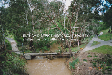
Photograph, Fay Bridge, Flood damage to footbridges over the Diamond Creek, Eltham, 14 November 2004
... Flood damage to footbridges over the Diamond Creek, Eltham......Footbridge...Fay Bridge Collection 2004-11-14 Bridge Street Bridge Diamond Creek (Creek) Diamond Street Bridge Flood damage floods Floodwater Footbridge main road bridge Susan Street Oval Withers Way 5 images - scanned from colour prints on loan Flood damage to footbridges over the Diamond Creek, Eltham Photograph Photograph Fay Bridge ...Significant flood events occurred Nov-Dec 2004 and Jan-Feb 2005.fay bridge collection, 2004-11-14, bridge street bridge, diamond creek (creek), diamond street bridge, flood damage, floods, floodwater, footbridge, main road bridge, susan street oval, withers way -
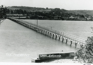
 Lakes Entrance Historical Society
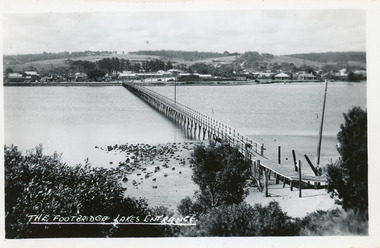
Postcard - Footbridge Lakes Entrance Victoria c1940, Bulmer HD
... Black and white postcard of the footbridge over the Cunninghame Arm. It shows natural vegetation in the foreground the ramp extension to the bridge, rocks at waters edge town beyond northern shore....The Footbridge Lakes Entrance...Bridges Waterways Township The Footbridge Lakes Entrance Black and white postcard of the footbridge over the Cunninghame Arm. ...Black and white postcard of the footbridge over the Cunninghame Arm. It shows natural vegetation in the foreground the ramp extension to the bridge, rocks at waters edge town beyond northern shore.The Footbridge Lakes Entrance bridges, waterways, township -
 Lakes Entrance Historical Society
Domestic object - Souvenirs
... One ashtray has scene of Footbridge at Lakes Entrance and the other has a photograph of Broome's Federal Hotel Lakes Entrance....Broome's Federal and Footbridge...Lakes Entrance Historical Society 4 Marine Parade Lakes Entrance gippsland One ashtray has scene of Footbridge at Lakes Entrance and the other has a photograph of Broome's Federal Hotel Lakes Entrance. souvenirs Broome's Federal and Footbridge Two glass ashtrays Domestic object Souvenirs ...One ashtray has scene of Footbridge at Lakes Entrance and the other has a photograph of Broome's Federal Hotel Lakes Entrance.Two glass ashtraysBroome's Federal and Footbridgesouvenirs -
 Numurkah & District Historical Society
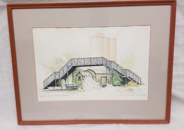
Painting - Water colour painting of Numurkah Railway footbridge & goods shed
... Wooden framed, glass covered water coloured print of Numurkah Railway Station footbridge & goods shed, with silo in background...Numurkah Railway Station & Footbridge / Vicki Wilkinson-Byme 1988...Numurkah & District Historical Society Old Bank Building cnr Melville and Knox Street (118-120 Melville St) Numurkah the-murray Numurkah Railway Station & Footbridge / Vicki Wilkinson-Byme 1988 Wooden framed, glass covered water coloured print of Numurkah Railway Station footbridge & goods shed, with silo in background Painting Water colour painting of Numurkah Railway footbridge & goods shed ...Wooden framed, glass covered water coloured print of Numurkah Railway Station footbridge & goods shed, with silo in backgroundNumurkah Railway Station & Footbridge / Vicki Wilkinson-Byme 1988 -
 Lakes Entrance Historical Society
Postcard - Footbridge Lakes Entrance c1950
... Black and white small format postcard of footbridge over Cunninghame Arm. It shows people on bare sand dunes in foreground boat moored beside bridge, motor vehicles parked along retaining wall on North shore with town buildings in background. ...Footbridge Lakes Entrance...2 copies 6 x 9 Bridges Waterways Township People Footbridge Lakes Entrance Black and white small format postcard of footbridge over Cunninghame Arm. ...2 copies 6 x 9Black and white small format postcard of footbridge over Cunninghame Arm. It shows people on bare sand dunes in foreground boat moored beside bridge, motor vehicles parked along retaining wall on North shore with town buildings in background. Footbridge Lakes Entrancebridges, waterways, township, people -
 Lakes Entrance Historical Society
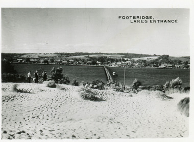
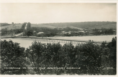
Postcard - Footbridge Lakes Entrance Victoria c1940, No14 Bulmer HD
... Black and white small format postcard of the footbridge across the Cunninghame Arm, which is the access to the southern shore and ocean beach from the town. ...Footbridge to Ninety Mile Beach, Lakes Entrance...Lakes Entrance Victoria Postcard Footbridge Lakes Entrance Victoria c1940 No14 Bulmer HD ...1 same image 6.5x10.5 valentine Series donated by Keith West|1 other similar image 6.5 x 10.5|1 other similar image 9 x 14|1 other similar postcard, message on back in Spares BoxBlack and white small format postcard of the footbridge across the Cunninghame Arm, which is the access to the southern shore and ocean beach from the town. Lakes Entrance VictoriaFootbridge to Ninety Mile Beach, Lakes Entrance bridges, waterways, township -
 Lakes Entrance Historical Society
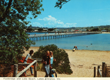
Postcard - Footbridge Cunninghame Arm Lakes Entrance c1970
... Colour postcards showing views of footbridge, part of Cunninghame Arm, east end of township and Myer Street hill in background and approach to ocean beach Lakes Entrance Victoria...Footbridge and lake beach Lakes Entrance Vic...Bridges Footbridge and lake beach Lakes Entrance Vic Colour postcards showing views of footbridge, part of Cunninghame Arm, east end of township and Myer Street hill in background and approach to ocean beach Lakes Entrance Victoria Postcard Footbridge Cunninghame Arm Lakes Entrance c1970 ...Colour postcards showing views of footbridge, part of Cunninghame Arm, east end of township and Myer Street hill in background and approach to ocean beach Lakes Entrance VictoriaFootbridge and lake beach Lakes Entrance Vicbridges -
 Surrey Hills Historical Society Collection
Photograph, Footbridge across Back Creek, 1980, 1980
... Footbridge across Back Creek, 1980......footbridges...The family sold the land to the Camberwell Council in the 1950s. The original footbridge was opened by Sir Winston Dugan in 1936....Black and white photo of a wooden footbridge with large trees and shrubs obscuring its surrounds....Footbridge across Back Creek, 1980 Photograph Photograph ...South Surrey Park was developed on land which had been the property of the Kleinert family. Their land extended from Union Road to Essex Road. They ran horses, ducks and fowls and Emily Kleinert grew flowers. Alan Holt research: Lot 6 was sold to Martin Klienert by Karl Richter in 1860 together with a portion of another adjacent lot. From 1860-1885 Martin worked it as a market garden leasing some land for grazing when it was not required for gardening. He died in 1898. In a formal document, William declared he was the son of Martin "who purchased land in 1860, died in 1898 and the land has been continually occupied by father and family since. It has been cultivated as a market garden; when not being used for gardening it was let for cultivation and grazing." William died in 1939 and the property passed to his sons Martin and Ernest. The family sold the land to the Camberwell Council in the 1950s. The original footbridge was opened by Sir Winston Dugan in 1936.Black and white photo of a wooden footbridge with large trees and shrubs obscuring its surrounds.parks and reserves, creeks, south surrey park, back creek, verdun street, footbridges -
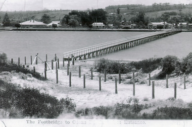
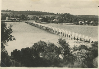
 Lakes Entrance Historical Society
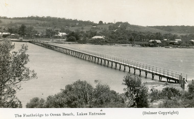
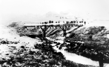
Postcard - Footbridge Lakes Entrance Victoria c1937
... Black and white postcard showing waterfront, some buildings along esplanade, no buildings on Myer St Hill. Footbridge across Cunninghame Arm completed to high tide mark, ramp constructed later, scrub in foreground. ...The Footbridge to Ocean Beach Lakes Entrance...Postcard Footbridge Lakes Entrance Victoria c1937 ...Copies as follows|One Miniture postcard tinted 6.5 x 9|One Black and white copy 6.5 x 11|One Tinted copy 20 x 28|One Postcard 17 x 12Black and white postcard showing waterfront, some buildings along esplanade, no buildings on Myer St Hill. Footbridge across Cunninghame Arm completed to high tide mark, ramp constructed later, scrub in foreground. The Footbridge to Ocean Beach Lakes Entrancevegetation, bridges, waterways, township -
 Lakes Entrance Historical Society
Photograph - Cunninghame Arm footbridge Lakes Entrance Victoria. c1937, 1937c
... Black and white photograph showing waterfront, Esplanade, some buildings and background hill almost completed footbridge across Cunninghame Arm. Posts defining pathway over sand dune to ocean beach. ...Footbridge to Ocean Beach, Lakes Entrance...Lakes Entrance Victoria Photograph Cunninghame Arm footbridge Lakes Entrance Victoria. c1937 ...Two other copies 6.5 x 9 imageBlack and white photograph showing waterfront, Esplanade, some buildings and background hill almost completed footbridge across Cunninghame Arm. Posts defining pathway over sand dune to ocean beach. Lakes Entrance VictoriaFootbridge to Ocean Beach, Lakes Entrancewaterways, bridges, township -
 Port Fairy Historical Society Museum and Archives
Photograph
... Moyne River Footbridge...Coloured photograph of the Moyne river taken from the West side of the footbridge looking to the wharf...Port Fairy Historical Society Museum and Archives 30 Gipps Street Port Fairy great-ocean-road Moyne River Footbridge moyne river foot bridge jetties Wharf boats Coloured photograph of the Moyne river taken from the West side of the footbridge looking to the wharf Photograph Photograph ...Moyne River FootbridgeColoured photograph of the Moyne river taken from the West side of the footbridge looking to the wharfmoyne river, foot bridge, jetties, wharf, boats -
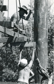 Lakes Entrance Historical Society
Photograph - Bridges, Bairnsdale Advertiser, 1990
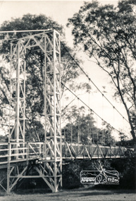
... Also a second photograph showing men constructing the footbridge....Black and white photograph showing Army Reservists building the suspension footbridge over the backwater near Bairnsdale, Victoria...Lakes Entrance Historical Society 4 Marine Parade Lakes Entrance gippsland Also a second photograph showing men constructing the footbridge. Boats and Boating Bridges Waterways Construction Black and white photograph showing Army Reservists building the suspension footbridge over the backwater near Bairnsdale, Victoria Photograph Bridges Bairnsdale Advertiser ...Also a second photograph showing men constructing the footbridge.Black and white photograph showing Army Reservists building the suspension footbridge over the backwater near Bairnsdale, Victoriaboats and boating, bridges, waterways, construction -
 Lakes Entrance Historical Society
Photograph - Foreshore Lakes Entrance, Lakes Entrance Tidy Town Committee
... Also a colour photograph of toilet block at North end of footbridge taken from the car park on the Eastern side 04268.1 20 x 15cm...Also a second photo showing toilet block near the footbridge...Also a second photo showing toilet block near the footbridge Foreshore Lakes Entrance Photograph Foreshore Lakes Entrance Lakes Entrance Tidy Town Committee ...Also a colour photograph of toilet block at North end of footbridge taken from the car park on the Eastern side 04268.1 20 x 15cmColour photograph taken from the forecourt at the North end of the footbridge looking towards the service station on the corner of Myers Street and Esplanade Lakes Entrance Victoria. Also a second photo showing toilet block near the footbridgebridges, people -
 Surrey Hills Historical Society Collection
Photograph, Opening of the footbridge across Back Creek, 1936, 1936
... Opening of the footbridge across Back Creek, 1936......footbridges...This photo was taken at the opening of the footbridge over Back Creek by Sir Winston Dugan, Governor of Victoria, in 1936. ...Black and white photo taken at the opening of the footbridge across Back Creek in the area later known as South Surrey Park. ...Opening of the footbridge across Back Creek, 1936 Photograph Photograph Ken Hall ...This photo was taken at the opening of the footbridge over Back Creek by Sir Winston Dugan, Governor of Victoria, in 1936. He is cutting bunting draped along the bridge rails. South Surrey Park was developed on land which had been the property of the Kleinert family. Their land extended from Union Road to Essex Road. They ran horses, ducks and fowls and Emily Kleinert grew flowers. Alan Holt research: Lot 6 was sold to Martin Klienert by Karl Richter in 1860 together with a portion of another adjacent lot. From 1860-1885 Martin worked it as a market garden leasing some land for grazing when it was not required for gardening. He died in 1898. In a formal document, William declared he was the son of Martin "who purchased land in 1860, died in 1898 and the land has been continually occupied by father and family since. It has been cultivated as a market garden; when not being used for gardening it was let for cultivation and grazing." William died in 1939 and the property passed to his sons Martin and Ernest. The family sold the land to the Camberwell Council in the 1950s.This photo is significant as it documents the change from rural to urban land use in the area.Black and white photo taken at the opening of the footbridge across Back Creek in the area later known as South Surrey Park. Back Creek runs diagonally through the photo with a wooden footbridge prominent. Dignitaries are gathered on the bridge. A tent and houses can just be distinguished in the background.parks and reserves, creeks, south surrey park, civic occasion, official events, back creek, verdun street, footbridges, governor of victoria, sir winston duggan, surrey hills, kleinert family, (mr) karl richter, (mr) martin kleinert, topography -
Surrey Hills Historical Society Collection
Photograph, Opening of the footbridge across Back Creek, 1936, 1936
... Opening of the footbridge across Back Creek, 1936......footbridges...This photo was taken at the opening of the footbridge over Back Creek by Sir Winston Dugan, Governor of Victoria, in 1936. ...Black and white photo taken at the opening of the footbridge across Back Creek in the area later known as South Surrey Park. ...Opening of the footbridge across Back Creek, 1936 Photograph Photograph Ken Hall ...This photo was taken at the opening of the footbridge over Back Creek by Sir Winston Dugan, Governor of Victoria, in 1936. He is cutting bunting draped along the bridge rails. South Surrey Park was developed on land which had been the property of the Kleinert family. Their land extended from Union Road to Essex Road. They ran horses, ducks and fowls and Emily Kleinert grew flowers. Alan Holt research: Lot 6 was sold to Martin Klienert by Karl Richter in 1860 together with a portion of another adjacent lot. From 1860-1885 Martin worked it as a market garden leasing some land for grazing when it was not required for gardening. He died in 1898. In a formal document, William declared he was the son of Martin "who purchased land in 1860, died in 1898 and the land has been continually occupied by father and family since. It has been cultivated as a market garden; when not being used for gardening it was let for cultivation and grazing." William died in 1939 and the property passed to his sons Martin and Ernest. The family sold the land to the Camberwell Council in the 1950s.This photo is significant as it documents the change from rural to urban land use in the area.Black and white photo taken at the opening of the footbridge across Back Creek in the area later known as South Surrey Park. Back Creek runs diagonally through the photo with a wooden footbridge prominent. Dignitaries are gathered on the bridge. A tent and houses can just be distinguished in the background.parks and reserves, creeks, south surrey park, civic occasion, official events, back creek, verdun street, footbridges, governor of victoria, sir winston duggan, surrey hills, kleinert family, (mr) karl richter, (mr) martin kleinert, topography -
 Lakes Entrance Historical Society
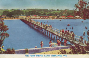
Photograph - Cunninghame Arm footbridge Lakes Entrance Victoria. c1955, Rose Series, 1955 c
... Cunninghame Arm footbridge Lakes Entrance Victoria. c1955....Also another colour postcard similar view of footbridge made by Murray Views donor Susan Samuel 2 January 2015 number 04272.1, 9 x 14 cm...Also another colour postcard similar view of footbridge ...Also another colour postcard similar view of footbridge Cunninghame Arm footbridge Lakes Entrance Victoria. c1955. ...Cunninghame Arm footbridge showing crowd on bridge, cars parked on Esplanade, new concrete wall between dunes and lake at south end of bridge Lakes Entrance Victoria. c1955. Also another colour postcard similar view of footbridge made by Murray Views donor Susan Samuel 2 January 2015 number 04272.1, 9 x 14 cmColour postcard taken from south end of the Cunninghame Arm footbridge showing crowd on bridge, cars parked on Esplanade, new concrete wall between dunes and lake at south end of bridge Lakes Entrance Victoria. c1955. Also another colour postcard similar view of footbridge The Foot-Bridge, Lakes Entrance. Vicrecreation, waterfront, land reclamation, gippsland lakes -
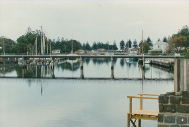
 Lakes Entrance Historical Society
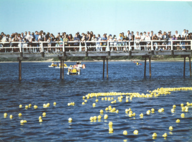
Photograph - Cunninghame Arm footbridge, LE Tidy Town Committee, Lakes Entrance Victoria, 1994 c
... Also a colour photograph of four people at picnic table adjacent to Northern end of Cunninghame Arm Footbridge Lakes Entrance 05158.1. 10 x 15 cm...Also a colour photograph of four people at picnic table adjacent to Northern end of Cunninghame Arm Footbridge Lakes Entrance...Also a colour photograph of four people at picnic table adjacent to Northern end of Cunninghame Arm Footbridge Lakes Entrance Lakes Entrance Victoria Photograph Cunninghame Arm footbridge LE Tidy Town Committee ...Also a colour photograph of four people at picnic table adjacent to Northern end of Cunninghame Arm Footbridge Lakes Entrance 05158.1. 10 x 15 cmColour photograph showing crowd of people on Cunninghame Arm footbridge at start of the Duck Race a local fundraiser with paddle boats in background Lakes Entrance Victoria. Also a colour photograph of four people at picnic table adjacent to Northern end of Cunninghame Arm Footbridge Lakes Entrancewaterfront, bridges -
 Lakes Entrance Historical Society
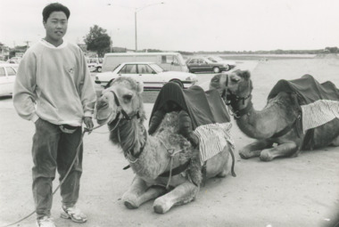
Photograph - Woodend Camel Farm Lakes Entrance Victoria, Lakes Post Newspaper, 1/12/1995 12:00:00 AM
... Kym Handley of Woodend Camel Farm with two camels on the sand area east of the Footbridge Lakes Entrance Victoria...Black and white photograph showing Kym Handley of Woodend Camel Farm with two camels on the sand area east of the Footbridge Lakes Entrance Victoria...Lakes Entrance Historical Society 4 Marine Parade Lakes Entrance gippsland Kym Handley of Woodend Camel Farm with two camels on the sand area east of the Footbridge Lakes Entrance Victoria Tourism Festival Animals Farm Black and white photograph showing Kym Handley of Woodend Camel Farm with two camels on the sand area east of the Footbridge Lakes Entrance Victoria Woodend Camel Farm Lakes Entrance Victoria Photograph Woodend Camel Farm Lakes Entrance Victoria Lakes Post Newspaper ...Kym Handley of Woodend Camel Farm with two camels on the sand area east of the Footbridge Lakes Entrance VictoriaBlack and white photograph showing Kym Handley of Woodend Camel Farm with two camels on the sand area east of the Footbridge Lakes Entrance Victoriatourism, festival, animals, farm -
 Lakes Entrance Historical Society
Postcard - Cunninghame Arm footbridge Lakes Entrance Victoria, H D Bulmer, 1940
... Cunninghame Arm footbridge Lakes Entrance Victoria ...Also two black and white postcards looking across footbridge to township 04271.1, 04271.2 size 9.5 x 14 cm 1940 c...Also two black and white postcards looking across footbridge to township 04271.1, 04271.2 size 9.5 x 14 cm 1940 c...Also two black and white postcards looking across footbridge to township 04271.1, 04271.2 size 9.5 x 14 cm 1940 c Cunninghame Arm footbridge Lakes Entrance Victoria Postcard Cunninghame Arm footbridge Lakes Entrance Victoria H D Bulmer ...Also two black and white postcards looking across footbridge to township 04271.1, 04271.2 size 9.5 x 14 cm 1940 cBlack and white postcard of Cunninghame Arm footbridge taken from the top of the sand dunes looking towards the few houses of Lakes Entrance Victoria Stamp on back The Lakes Studio Lakes Entrance. Also two black and white postcards looking across footbridge to township 04271.1, 04271.2 size 9.5 x 14 cm 1940 cbridges, recreational facilities, surf lifesaving, waterfront -
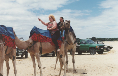 Lakes Entrance Historical Society
Photograph - Camels at Lakes Entrance, Lakes Post Newspaper, 1996 c
... three camels and two people, female rider taking a selfie while on camel ride on the sand beach east side of the Footbridge Lakes Entrance Victoria Also two more colour photographs showing the four camels and the attendants on the beach east of the Footbridge number 04179.1 size 10 x 15 cm, and 04179.2 size 10 x 15 cm...Colour photograph showing three camels and two people, female rider taking a selfie while on camel ride on the sand beach east side of the Footbridge Lakes Entrance Victoria.Also two more colour photographs showing the four camels and the attendants on the beach east of the Footbridge number 04179.1 size 10 x 15 cm, and 04179.2 size 10 x 15 cm ...Lakes Entrance Historical Society 4 Marine Parade Lakes Entrance gippsland three camels and two people, female rider taking a selfie while on camel ride on the sand beach east side of the Footbridge Lakes Entrance Victoria Also two more colour photographs showing the four camels and the attendants on the beach east of the Footbridge number 04179.1 size 10 x 15 cm, and 04179.2 size 10 x 15 cm Tourism Beaches Business Colour photograph showing three camels and two people, female rider taking a selfie while on camel ride on the sand beach east side of the Footbridge Lakes Entrance Victoria.Also two more colour photographs showing the four camels and the attendants on the beach east of the Footbridge number 04179.1 size 10 x 15 cm, and 04179.2 size 10 x 15 cm Camels at Lakes Entrance Photograph Camels at Lakes Entrance Lakes Post Newspaper ...three camels and two people, female rider taking a selfie while on camel ride on the sand beach east side of the Footbridge Lakes Entrance Victoria Also two more colour photographs showing the four camels and the attendants on the beach east of the Footbridge number 04179.1 size 10 x 15 cm, and 04179.2 size 10 x 15 cmColour photograph showing three camels and two people, female rider taking a selfie while on camel ride on the sand beach east side of the Footbridge Lakes Entrance Victoria.Also two more colour photographs showing the four camels and the attendants on the beach east of the Footbridge number 04179.1 size 10 x 15 cm, and 04179.2 size 10 x 15 cm tourism, beaches, business -
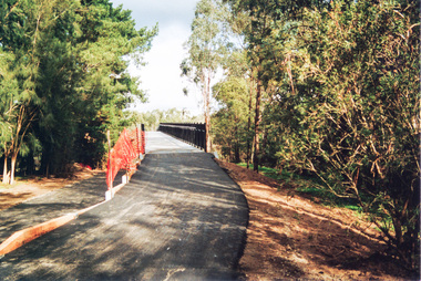 Eltham District Historical Society Inc
Photograph, Doug Orford, Completion of bridge works across Yarra River at rear of Eltham Lower Park, July 2004
... The Yarra River Footbridge was opened in August 2004 and links the Diamond Creek Trail between the Shire of Nillumbik and City of Manningham. ...Three colour photographs showing commencement of construction of Eltham-Templestowe footbridge over Yarra River off Homestead Road, Eltham which was completed July 2004. ...The Yarra River Footbridge was opened in August 2004 and links the Diamond Creek Trail between the Shire of Nillumbik and City of Manningham. ...Bitumen shared pathway under construction at the new Eltham-Templestowe footbridge over the Yarra River off Homestead Road, Eltham which was completed in July 2004. The Yarra River Footbridge was opened in August 2004 and links the Diamond Creek Trail between the Shire of Nillumbik and City of Manningham. It is a shared pathway and also links with the Main Yarra Trail. It affords lovely views over the Yarra River.Three colour photographs showing commencement of construction of Eltham-Templestowe footbridge over Yarra River off Homestead Road, Eltham which was completed July 2004. Third photograph of dedictaion plaque at opening 30 Aug 2004bridges, yarra river, eltham south, eltham lower park, lenister farm, homestead road, asphaldt, bitumen, shared pathway, diamond creek trail -
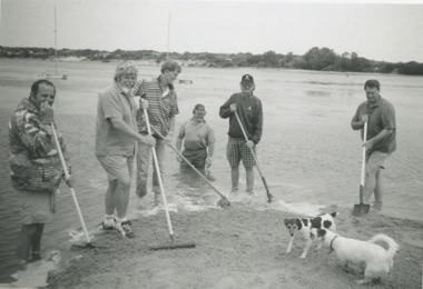 Lakes Entrance Historical Society
Photograph - Volunteer Beach Cleanup, Lakes Post Newspaper, 1996
... cleaning up beach area east of the footbridge Lakes Entrance VictoriaGerard Kelly, Mike Lorimer, Mal Martin, Denis McGrath coordinator Trevor McCubbin and Greg Horin - 1996...Black and white photograph showing Gerard Kelly, Mike Lorimer, Mal Martin, Denis McGrath coordinator Trevor McCubbin and Greg Horin cleaning up beach area east of the footbridge Lakes Entrance Victoria...Lakes Entrance Historical Society 4 Marine Parade Lakes Entrance gippsland cleaning up beach area east of the footbridge Lakes Entrance VictoriaGerard Kelly, Mike Lorimer, Mal Martin, Denis McGrath coordinator Trevor McCubbin and Greg Horin - 1996 Volunteering People Beaches Black and white photograph showing Gerard Kelly, Mike Lorimer, Mal Martin, Denis McGrath coordinator Trevor McCubbin and Greg Horin cleaning up beach area east of the footbridge Lakes Entrance Victoria Photograph Volunteer Beach Cleanup Lakes Post Newspaper ...cleaning up beach area east of the footbridge Lakes Entrance VictoriaGerard Kelly, Mike Lorimer, Mal Martin, Denis McGrath coordinator Trevor McCubbin and Greg Horin - 1996Black and white photograph showing Gerard Kelly, Mike Lorimer, Mal Martin, Denis McGrath coordinator Trevor McCubbin and Greg Horin cleaning up beach area east of the footbridge Lakes Entrance Victoriavolunteering, people, beaches -
 Lakes Entrance Historical Society
Photograph - Footbridge Lakes Entrance Victoria c1940, Bulmer HD
... The Footbridge Lakes Entrance...1 black and white copy 13x18 has glue on back|1 copy tinted 9x14 Bridges Waterways Township The Footbridge Lakes Entrance Black and white photograph of the foot bridge over the Cunninghame Arm. ...1 black and white copy 13x18 has glue on back|1 copy tinted 9x14Black and white photograph of the foot bridge over the Cunninghame Arm. It shows a concrete wall at the edge of lake in foreground, two light poles on the bridge buildings on Esplanade and Myer Street. The Footbridge Lakes Entrancebridges, waterways, township -
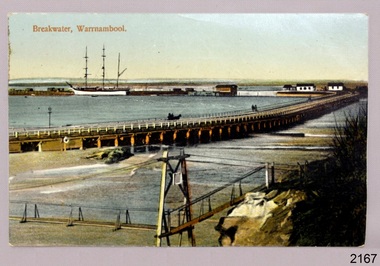 Flagstaff Hill Maritime Museum and Village
Postcard - Historical, maritime, Breakwater, Warrnambool, ca. 1890
... The local photograph shows the original footbridge across the Merri River near its mouth, the Viaduct road and the Warrnambool Breakwater with the Titan crane on it. ...Postcard, coloured, of the Warrnambool Breakwater, with the Merri River footbridge and the Viaduct in the foreground. ...The Viaduct has since been filled in to prevent water from passing through the pylons, and the footbridge has been replaced. The postcard has a personal message written on the back to a Dr Scott from May. ...The local photograph shows the original footbridge across the Merri River near its mouth, the Viaduct road and the Warrnambool Breakwater with the Titan crane on it. The breakwater's construction was completed in 1890, the year this photograph was taken. The Viaduct has since been filled in to prevent water from passing through the pylons, and the footbridge has been replaced. The postcard has a personal message written on the back to a Dr Scott from May. The photograph is locally significant for recording the completion of the Warrnambool Breakwater, for showing the original design of the Viaduct and for a clear view of the original footbridge across the Merri River. It is also of significance for being used by a female to send a greeting from Warrnambool to a doctor. Postcard, coloured, of the Warrnambool Breakwater, with the Merri River footbridge and the Viaduct in the foreground. Pedestrians and a horse-drawn cart are on the Viaduct, The lifeboat house and other buildings are near the beginning of the Breakwater. A three-masted sailing ship is in port. The photograph was taken from Middle Island. A personal message is written on the back, and a title is printed on the front. Produced in Germany in the 1890s.On the front: "Breakwater, Warrnambool" Written on the reverse: "Warrnambool Wishing Dear Dr Scott the Compliments of the Season With love and best wishes, From May"warrnambool, shipwreck coast, flagstaff hill, flagstaff hill maritime museum, flagstaff hill maritime village, postcard, coloured postcard, warrnambool breakwater, breakwater, viaduct, 1890s, merri river footbridge, dr scott, may -
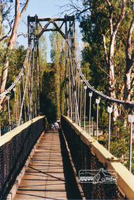 Eltham District Historical Society Inc
Photograph, Pedestrian suspension bridge over the Yarra River at Lower Plenty
... Because of the poor and circuitous road access, a suspension footbridge was built across the river. As well as providing easy access for the priests residents of Templestowe could attend services at the seminary. ...Colour photograph of footbridge over Yarra River, part of the Ruffey Trail just off the Main Yarra Trail near the former seminary (now Odyssey House) Lower Plenty...Because of the poor and circuitous road access, a suspension footbridge was built across the river. As well as providing easy access for the priests residents of Templestowe could attend services at the seminary. ...Odyssey House drug rehabilitation centre in Bonds Road, Lower Plenty is a distinctive landmark, especially when viewed from across the Yarra at Templestowe. It was built in the 1950’s as a seminary for the Blessed Sacrament Fathers. Because of the poor and circuitous road access, a suspension footbridge was built across the river. As well as providing easy access for the priests residents of Templestowe could attend services at the seminary. The bridge is now part of the Yarra Trails system.Colour photograph of footbridge over Yarra River, part of the Ruffey Trail just off the Main Yarra Trail near the former seminary (now Odyssey House) Lower Plentybridges, yarra river, lower plenty, seminary, blessed sacrament fathers, odyssey house, bonds road -
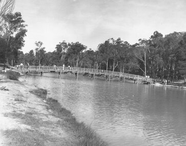 Ringwood and District Historical Society
Photograph, Ringwood Lake, 1973. Previously Sandy Gully Creek (1854)
... Image shows a footbridge over the lake....Image shows a footbridge over the lake. Black and white photograph Ringwood Lake, 1973. ...Black and white photographImage shows a footbridge over the lake. -
 Eltham District Historical Society Inc
Photograph, Pedestrian suspension bridge over the Yarra River at Lower Plenty
... Because of the poor and circuitous road access, a suspension footbridge was built across the river. As well as providing easy access for the priests residents of Templestowe could attend services at the seminary. ...Two black and white photographs of footbridge over Yarra River, part of the Ruffey Trail just off the Main Yarra Trail near the former seminary (now Odyssey House) Lower Plenty...Because of the poor and circuitous road access, a suspension footbridge was built across the river. As well as providing easy access for the priests residents of Templestowe could attend services at the seminary. ...Odyssey House drug rehabilitation centre in Bonds Road, Lower Plenty is a distinctive landmark, especially when viewed from across the Yarra at Templestowe. It was built in the 1950’s as a seminary for the Blessed Sacrament Fathers. Because of the poor and circuitous road access, a suspension footbridge was built across the river. As well as providing easy access for the priests residents of Templestowe could attend services at the seminary. The bridge is now part of the Yarra Trails system.Two black and white photographs of footbridge over Yarra River, part of the Ruffey Trail just off the Main Yarra Trail near the former seminary (now Odyssey House) Lower Plentybridges, yarra river, odyssey house, bonds road, lower plenty, seminary, blessed sacrament fathers -
 Lakes Entrance Historical Society
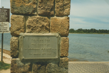
Photograph - Plaque on footbridge Lakes Entrance Victoria, Bessie Larkins, 1985
... plaque at Northern end of the footbridge noting the date of opening by Hon. ...Colour photograph of plaque at Northern end of the footbridge noting the date of opening by Hon. ...Lakes Entrance Historical Society 4 Marine Parade Lakes Entrance gippsland plaque at Northern end of the footbridge noting the date of opening by Hon. ...plaque at Northern end of the footbridge noting the date of opening by Hon. AE Lind MLA. View across Cunninghame Arm to timbered area at hummocks Lakes Entrance Victoria. Plus a second photo from the foot bridge looking east toward the rotundaColour photograph of plaque at Northern end of the footbridge noting the date of opening by Hon. AE Lind MLA. View across Cunninghame Arm to timbered area at hummocks Lakes Entrance Victoria. Plus a second photo from the foot bridge looking east toward the rotundabridges, waterways, gippsland lakes -
Port Melbourne Historical & Preservation Society
Plan - Footbridge, Borough of Sandridge, 1860 - 1884
... Plan for a footbridge, Borough of Sandridge, undated....Port Melbourne Historical & Preservation Society Port Melbourne Town Hall 333 Bay Street Port Melbourne melbourne Built Environment - Civic Charles CLAY Gordon FYFE Signed by Charles Clay and Gordon Fyfe. Plan for a footbridge, Borough of Sandridge, undated. Plan Footbridge, Borough of Sandridge ...Plan for a footbridge, Borough of Sandridge, undated.Signed by Charles Clay and Gordon Fyfe.built environment - civic, charles clay, gordon fyfe -
 Ringwood and District Historical Society
Photograph, Ringwood Lake, 1972. Three photographs
... Images show 3 views of the footbridge over the lake....Images show 3 views of the footbridge over the lake. Black and white photograph (3 images- RE0095 A,B,C.) ...Black and white photograph (3 images- RE0095 A,B,C.)Images show 3 views of the footbridge over the lake.