Showing 60 items matching "geographical names"
-
 Victorian Aboriginal Corporation for Languages
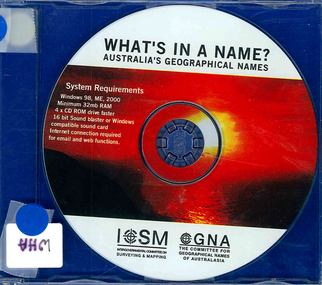
CD-ROM, Committee for Geographical Names of Australasia, What's in a name? : Australia's geographical names, 2002
... : Australia's geographical names...geographical names...Committee for Geographical Names of Australasia...: Australia's geographical names CD-ROM Committee for Geographical Names of Australasia ...CD-ROMgeographical names, gazetteers -
 Victorian Aboriginal Corporation for Languages
Video, Committee for Geographical Names of Australasia, What's in a name? : Australia's geographical names, 2002
... : Australia's geographical names...Committee for Geographical Names of Australasia...: Australia's geographical names Video Committee for Geographical Names of Australasia ...videocassetteindigenous place names -
 Eltham District Historical Society Inc
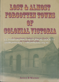
Book, Angus B. Watson, Lost & almost forgotten towns of colonial Victoria : a comprehensive analysis of census results for Victoria, 1841-1901, 2003
... ...Geographical Names Victoria...Cities and Towns Victoria History 19th Century Statistics Ghost Towns - Victoria Geographical Names Victoria Victoria Census Soft cover, 519 p. : ill. ; 25 cm. includes index Lost & almost forgotten towns of colonial Victoria : a comprehensive analysis of census results for Victoria, 1841-1901 Book Book Angus B. ...Lists all towns and villages with entries in the Victorian censuses between 1841 and 1901. It includes in excess of 1400 entries with the latitude and longitude for each town, numbers males and females in the town, and the number of occupied dwellings (where available). For many of these settlements the only visible trace of them today is in the census results collected by the fledgling governments of Colonial Victoria. It is a comprehensive reference and a fascinating insight into the movements of early populations of new Australians.cities and towns victoria, history 19th century, statistics, ghost towns - victoria, geographical names victoria, victoria census -
 Victorian Aboriginal Corporation for Languages
Book, An alphabetical list of loose bags, parishes, shires, stations, butter factories, hamlets, state schools, streets, village settlements, and places not being post towns in the colony of Victoria
... Victorian geographical names...Victorian Aboriginal Corporation for Languages 33 Saxon Street Brunswick melbourne Victorian geographical names street names listing of place and street names Photocopy of the original document of c. 1895-1897 listing all places not a Post Town in Victoria. ...Photocopy of the original document of c. 1895-1897 listing all places not a Post Town in Victoria.listing of place and street namesvictorian geographical names, street names -
 Victorian Aboriginal Corporation for Languages
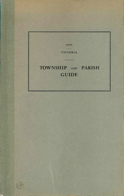
Book, Department of Crown Lands and Survey Victoria, Township and parish guide : Victoria, 1955
... Victorian geographical names...Victorian Aboriginal Corporation for Languages 33 Saxon Street Brunswick melbourne Victorian geographical names Victorian administration A alphabetical list of townships proclaimed under the Land Acts of Victoria. ...A alphabetical list of townships proclaimed under the Land Acts of Victoria. Shows the parish, land district and the municipality in which each is situated, and the particulars of Gazettal of Proclamation.victorian geographical names, victorian administration -
Phillip Island and District Historical Society Inc.
Book, REED, A.W, Aboriginal place names and their meanings, 1967
... names...geographical...Phillip Island and District Historical Society Inc. phillip-island-and-the-bass-coast names geographical australia australian languages Cowes Public Library Aboriginal place names and their meanings Book REED, A.W. ...Cowes Public Librarynames, geographical, australia, australian languages -
Koorie Heritage Trust
Book, Bader, Frances, Naming St. Kilda, 2007
... Names...Geographical -- Victoria -- St. Kilda. | St. ...Koorie Heritage Trust Levels 1 & 3, Yarra Building Federation Square, Melbourne melbourne Names Geographical -- Victoria -- St. Kilda. | St. ...Mentions the indigenous inhabitants of the area.i - vi; 214 P.; ports,; facs.; refs.; bib.; Mentions the indigenous inhabitants of the area. names, geographical -- victoria -- st. kilda. | st. kilda (vic.) -- name -- history. -
 Wonthaggi & District Historical Society
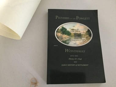
Book and Map, Barbara Moyle, Pioneers on tthe Powlett and at Wonthaggi 1878-1910, 2015
... Book - families social histories, maps, photograps Map - block numbers town names physical / geographical features...Wonthaggi & District Historical Society Murray Street Wonthaggi gippsland Book - families social histories, maps, photograps Map - block numbers town names physical / geographical features Farming and social history of pioneers of the Powlett River are prior to the establishment of the State Coal Mine at Wonthaggi. ...Book - families social histories, maps, photograps Map - block numbers town names physical / geographical featuresFarming and social history of pioneers of the Powlett River are prior to the establishment of the State Coal Mine at Wonthaggi. Significant land marks, buildings and photographs are included. Dark green cover with oval artists impression of Powlett river and bridge Associated map which covers the parishes plus key places of interestlPioneers on the Powlett and at Wonthaggi 1878-1910 Barbara R Moyle 2015 Early History of Settlement Map - Parish names, significant sitesfarming, pioneers of wonthaggi and district, wonthaggi families -
 Federation University Historical Collection
Book, The Plants Indigenous to the Colony of Victoria, 1865 (exact); "1864-1865, CR"
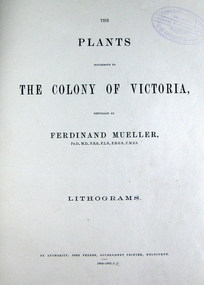
... Many of Australian geographical features were named after him such as: the Mueller Ranges (WA), Muellers Range (Qld), Mount Mueller (in WA, NT, Tas and Vic) and many more. ...Many of Australian geographical features were named after him such as: the Mueller Ranges (WA), Muellers Range (Qld), Mount Mueller (in WA, NT, Tas and Vic) and many more. ...Baron Sir Ferdinand Jacob Heinrich von Mueller was born in Germany on 30 June 1825. Ferdinand was a German-Australian physician, geographer, and a botanist. After passing the pharmaceutical examinations he studied botany at Kiel University. In 1847 he received the degree of Doctor of Philosophy from Kiel University.when he was 21 years old for a thesis on the flora of Schleswig-Holstein. In 1847, he moved to Adelaide, Australia and worked as a chemist. From 1848 to 1852 he travelled through the colony, discovering and describing a large number of unknown to Western science plants. He wrote a few papers to German periodicals on botanical subjects. In 1851, Mueller moved to Melbourne, capital of the new colony of Victoria. In 1853, He was appointed Government Botanist for Victoria by Governor Charles La Trobe. In 1873, Ferdinand received an honorary doctorate of the University of Rostock. In 1883, he was awarded the Clarke Medal by the Royal Society of New South Wales. He published many volumes on the Victorian plants. Many of Australian geographical features were named after him such as: the Mueller Ranges (WA), Muellers Range (Qld), Mount Mueller (in WA, NT, Tas and Vic) and many more. Mueller died in Melbourne on 10 October 1896 and is buried in the St. Kilda Cemetery A green cloth hard cover book. Title and author's name is engraved in gold on spine. It includes an introduction, a table of contents and plates. Lithograms in b/w. Each plate accompanied by a page with descriptive print. Number of plates XIII-LXXI. No. of supplement plates XII-XVII. The book illustrates Victorian plants and outlines the principal characters of those species. This book is No 1290 in the Original Register of Books (Cat. No. 005)Hand written pencil notes on contents page. Stamped throughout with "The School of Mines, Industries & Science, Ballarat. Ingenio Effodere Opes. In the University of Melbourne."australia, botany victoria, plants, ferdinand mueller, ferdinand von mueller, biodiversity, flora -
 Warrnambool and District Historical Society Inc.
Literary work - Antiquarian Book, Heroes of The United Service, 1901
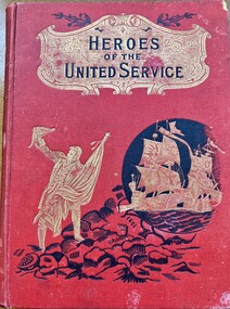
... geography,Spelling and dictation. Sadly he died in September 1901 from meningitis following influenza and pneumonia and is buried with other members of the Jackman family at the Clear Lake cemetery near Horsham. The two schools mentioned on the name...geography,Spelling and dictation. Sadly he died in September 1901 from meningitis following influenza and pneumonia and is buried with other members of the Jackman family at the Clear Lake cemetery near Horsham. The two schools mentioned on the name ...This book contains a number of stories which relate to heroes of the British Army and Navy . After a brief synopsis of the history of British military, it then commences from the conquest of Canada in 1759 and relates the stories of renown personnel through to the beginning of the 20th century.This book has a red cloth over card cover with black text mounted in a gold shield at the top of the cover with a gold figure of a sailor who is standing on black rocks. There is a gold image of two galleons inside a black circle. The spine has the title in black on a gold shield , similar to the front cover . The back cover is plain. It has 248 pages relating to the Armed Forces and 256 pages relating to naval stories.There are a number of colour plates and black and white drawings many depicting military scenes. Inside front and back covers are faced with brown and mustard coloured pages. There is a name plate inside the front cover. non-fictionThis book contains a number of stories which relate to heroes of the British Army and Navy . After a brief synopsis of the history of British military, it then commences from the conquest of Canada in 1759 and relates the stories of renown personnel through to the beginning of the 20th century.heroes of the united service, arthur jackman, jackman family, clear lake cemetery, jesuits st patricks college melbourne, jesuits st francis xavier melbourne, rector patrick keating -
 Warrnambool and District Historical Society Inc.
Book, African trader, Late 19th Century
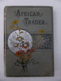
... ‘Ellerslie College, Warrnambool, Non Scholae Sed Vitae Discimus, Name. Miss Bessie Mackay, Class V, For Geography’. ...Ellerslie College, Warrnambool History of Warrnambool Bella Davidson William Lawson Bessie Mackay ‘Ellerslie College, Warrnambool, Non Scholae Sed Vitae Discimus, Name. Miss Bessie Mackay, Class V, For Geography’. This is a hard cover book of 128 pages. ...This is a book prize given to Bessie Mackay some time in the 1890s. Unfortunately neither the book nor the book plate has any date. Bessie Mackay is probably Marie Elizabeth Mackay, born to Thomas and Marie Mackay in 1883. Thomas Mackay was an auctioneer and commission agent in Warrnambool in the later decades of the 19th century. Ellerslie College was an important private school in Warrnambool and the building still stands (Koroit Street). It was a purpose-built school, initially for girls and it was erected in 1889 for Bella Davidson. Miss Davidson conducted this school until 1891 when it was taken over by William Lawson. He had had a school for boys and girls in King Street and when he moved his school to Ellerslie College he was employing three lady teachers as well as his male staff. It is not known whether Bessie Mackay was a pupil at Miss Davidson’s school or Lawson’s school or both. This book is of great interest as a memento of Ellerslie College, a well-known private school in Warrnambool in the late 19th century and early 20th century. At that time, most pupils in Warrnambool wishing to go on to higher education attended private schools. This is a hard cover book of 128 pages. The cover is dark green with an image of a bunch of flowers in silver, red and black colouring on the front cover and on the spine. The printing is in black lettering on the front cover and in silver colouring on the spine. The book has eight chapters with a full page colour sketch at the front of the book. The cover is slightly frayed and a little stained. The book plate has black printing on a white background and handwriting in black ink. ‘Ellerslie College, Warrnambool, Non Scholae Sed Vitae Discimus, Name. Miss Bessie Mackay, Class V, For Geography’. ellerslie college, warrnambool, history of warrnambool, bella davidson, william lawson, bessie mackay -
 Warrnambool and District Historical Society Inc.
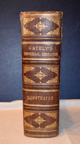
Book - educational encyclopaedia, Charles Beale & M. Gately, Gately's Universal Educator, 1886
... This book is an encyclopaedia containing three volumes within the one book and has information on such topics as natural history, geology, astronomy, geography, legal matters, history, agriculture, mathematics, music and poetry. No information has been found on the two names in the inscription but the way the date has been written suggests an American or other foreign influence....Warrnambool and District Historical Society Inc. 2 Gilles Street (south of Merri St) Warrnambool great-ocean-road This book is an encyclopaedia containing three volumes within the one book and has information on such topics as natural history, geology, astronomy, geography, legal matters, history, agriculture, mathematics, music and poetry. No information has been found on the two names in the inscription but the way the date has been written suggests an American or other foreign influence. ...An encyclopaedia and business guide (late 19th century)This book has a brown leather cover which is heavily embossed with brown and gold patterns and gold lettering, The spine is torn at the top and the cover is worn at the edges.The pages are gilt-edged and contain printed text and black and white sketches, illustrations, maps and diagrams. non-fictionAn encyclopaedia and business guide (late 19th century)19th century australia, 19th century encyclopaedia, 19th century business guide -
 Warrnambool and District Historical Society Inc.
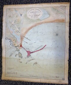
Map - Warrnambool Port 1879, 1879
... The chart detail is hand-drawn and hand-tinted on canvas with the names of places, geographical and marine features and local points of interest added in print. ...The chart detail is hand-drawn and hand-tinted on canvas with the names of places, geographical and marine features and local points of interest added in print. ...The port facilities in Warrnambool Bay were in constant use from the first years of Warrnambool’s settlement but there were also difficulties for the shipping trade – a small and unsafe anchorage, the lack of loading facilities and little natural protection from the southerly gales. From the 1870s on there was local agitation for some sort of Breakwater to be built and an Andrew Kerr design was approved by the Warrnambool Council but no funds were made available from the Victorian Government. Throughout the 1870s the building of a Breakwater was a major political issue in the district with preliminary work being funded and started in 1874. In 1879 the Government agreed to a further inspection of the area and an official report. Sir John Coode (1816-1892) was commissioned to make this report. He had come to Australia in 1872 to advise on harbour construction. Coode recommended a 1800 feet long Breakwater and wharf connected to the shore and it was this proposal that the plan described herein and drawn up in 1879 was to accompany. The original plan was eventually modified because of the cost and a Breakwater was completed in 1890 under the direction of the engineer, Arthur Dudley Dobson, with extensions early in the 20th century. This plan is of great interest as it shows in simple graphic form the original plans proposed by Sir John Coode for the Warrnambool Breakwater. It is therefore of great historical importance. The Breakwater was not the maritime success that it was hoped it would be but it is today a significant feature of our foreshore. This is a Plan drawn up in 1879 by Victorian Harbours to accompany Sir John Coode’s Report on the proposed Warrnambool Breakwater. The chart detail is hand-drawn and hand-tinted on canvas with the names of places, geographical and marine features and local points of interest added in print. The edges of the chart are rubbed and the chart is somewhat faded and dirty but the main colours of red, green and brown are still clearly discernible. The title of the plan is printed in an oval inset at the top of the chart. The plan shows two possible Breakwater designs, one from the Borough Surveyor (Andrew Kerr?) and one from Sir John Coode.Victorian Harbours Warrnambool Plan to accompany Sir John Coode’s report Dated 28th Feby 1879 warrnambool breakwater, andrew kerr, sir john coode, arthur dudley dobson, warrnambool, warrnambool harbour, warrnambool history, warrnambool beach -
 Bendigo Military Museum
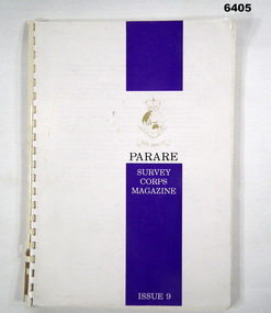
Magazine - "Parare" Survey Corps Magazine Issue 9, Royal Australian Survey Corps, 1993
... Names mentioned in "Unit sports pages 73, 74. Exercise Kokoda Cartographer July 1992 list of participants on Page 78. Iraq - The Gulf War, Topographic Support page 52. Adelaide (4 Fd Svy Sqn) 1992 page 65. 8 Fd Svy Sqn manning wind down list pages 89-90. Military Geographic...Names mentioned in "Unit sports pages 73, 74. Exercise Kokoda Cartographer July 1992 list of participants on Page 78. Iraq - The Gulf War, Topographic Support page 52. Adelaide (4 Fd Svy Sqn) 1992 page 65. 8 Fd Svy Sqn manning wind down list pages 89-90. Military Geographic ...An annual magazine published for release on RASvy Corps birthday 1st July. All units with RASvy Corps are invited / expected to submit an article depicting their activities over the preceding years 1991 to 1993. 4Fd Svy Sqn Adventure training list pages 7, 8. Army Map Depot - Unit Ski Day, pages 20, 21. The William Patton Expedition - Locating his grave as part of the " Burke and Wills " expedition, list of personnel involved - page 43. 8 Fd Svy Sqn - names mentioned and photo - page 50. 4 Fd Svy Sqn (1992) names mentioned page 69. The G Res manning list on page 70. Names mentioned in "Unit sports pages 73, 74. Exercise Kokoda Cartographer July 1992 list of participants on Page 78. Iraq - The Gulf War, Topographic Support page 52. Adelaide (4 Fd Svy Sqn) 1992 page 65. 8 Fd Svy Sqn manning wind down list pages 89-90. Military Geographic Information Pilot Project page 92. Royal Australian Survey Corps Aerial photography Team personnel list page 95. Operation Belama 92 Team list page 96. Long term Schooling attendees and promotions, page 105. Litho Sqn Postings in and out pages 116-117. Special awards SGT Durrant page 113, SSGT SR Hill page 114. RASvy completes 1:50,000 scale mapping of the Pilbara Region page 121. 1st Topo Svy Sqn personnel mentioned on page 122. A4 sized booklet with soft glossy card covers, paper pages held together with a plastic spiral binder.army survey regiment, army survey regt, fortuna, royal australian survey corps, rasvy, asr -
 Emerald Museum & Nobelius Heritage Park
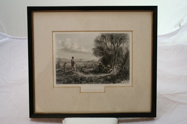
Relief prints, Thomas Baines et al, An Explorer's Camp, Circa 1875
... Thomas Baines joined Augustus Gregory as official artist and storekeeper, in the expedition across northern Australia between 1855-1857 sponsored by the Royal Geographical Society to evaluate the northern area of Australia for suitability as a colonial settlement. The Baines River was named after him....Thomas Baines joined Augustus Gregory as official artist and storekeeper, in the expedition across northern Australia between 1855-1857 sponsored by the Royal Geographical Society to evaluate the northern area of Australia for suitability as a colonial settlement. The Baines River was named after him....Thomas Baines joined Augustus Gregory as official artist and storekeeper, in the expedition across northern Australia between 1855-1857 sponsored by the Royal Geographical Society to evaluate the northern area of Australia for suitability as a colonial settlement. The Baines River was named after him. ...From 'Australia' by Edwin Carton Booth. Thomas Baines joined Augustus Gregory as official artist and storekeeper, in the expedition across northern Australia between 1855-1857 sponsored by the Royal Geographical Society to evaluate the northern area of Australia for suitability as a colonial settlement. The Baines River was named after him.The item is socially and artistically significant as it is a very early image of Northern Australia.Framed black and white etching depicting a cap site located near the ocean.Artist T. Baines - J.J. Crew. From 'Australia' by Edwin Carton Booth. Thomas Baines joined Augustus Gregory as official artist and storekeeper, in the expedition across northern Australia between 1855-1857 sponsored by the Royal Geographical Society to evaluate the northern area of Australia for suitability as a colonial settlement. The Baines River was named after him.print, baines -
 Ballarat Clarendon College
Book, Queechy, 1885
... Geography in the fourth form. Amy entered Ballarat College in January of 1885 at the age of 12. Parent/Guardian named in Registry as Ed Bailey residing in [Mt. ...Geography in the fourth form. Amy entered Ballarat College in January of 1885 at the age of 12. Parent/Guardian named in Registry as Ed Bailey residing in [Mt. ...This book was awarded to Amy Evelyn Bailey for second prize in Geography in the fourth form. Amy entered Ballarat College in January of 1885 at the age of 12. Parent/Guardian named in Registry as Ed Bailey residing in [Mt. Rowan?]. It is also noted in the Register that Amy came from Miss. [Keeps?] Ladies' School.During 1877 - 1891 Ballarat College accepted enrolments from female students. The school holds the original register of this period and notes that Amy Bailey entered the College at the age of 12. Presbyterian educators placed great value on a classical education matched with diligence in study. Book prizes were highly regarded and academic success admired. In the school’s early years prizes were ordered direct from London and had the school crest embossed in gold on the front or back cover. Many of the prizes given in early years were returned to the school to equip the Weatherly Library when it opened in 1936.Bound in red half calf with marble edging, gilt lettering and decoration on spine. Six raised bands on spine with gold decoration; gold writing on second compartment with green calf; College crest embossed on front cover; colour illustrations, end papers marbled, slight foxing on pages, detached spine, 670 p.Book plate inside front cover: college crest, Geography/ Fourth Form/ Second prize/ Awarded to/ Amy E. Bailey./ Christmas,1886.amy-evelyn-bailey, ballarat-college, ed-bailey, miss.-[keeps?]-ladies'-college -
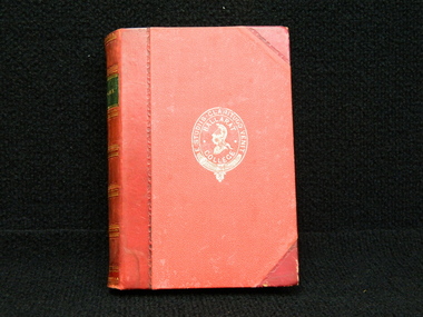
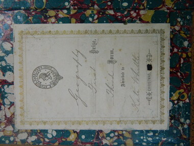
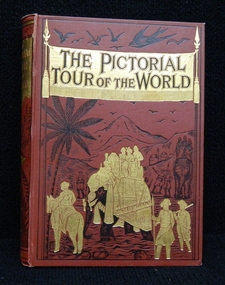 Ballarat Clarendon College
Book, Frederick Warne and Co, The pictorial tour of the world, Prior to the book prize given on December, 1897
... Geography. May entered Clarendon Ladies' College in 1891. On the original register father's name is listed as William and the residence as Neil St, Ballarat....Geography. May entered Clarendon Ladies' College in 1891. On the original register father's name is listed as William and the residence as Neil St, Ballarat. ...This book was awarded to May Adelaide Anstis in 1897 for first prize in Geography. May entered Clarendon Ladies' College in 1891. On the original register father's name is listed as William and the residence as Neil St, Ballarat.Presbyterian educators placed great value on a classical education matched with diligence in study. Book prizes were highly regarded and academic success admired. In the school’s early years prizes were ordered direct from London and had the school crest embossed in gold on the front or back cover. Many of the prizes given in early years were returned to the school to equip the Weatherly Library when it opened in 1936.Bound in red calf with gilt and black illustrations on front cover and spine. Gilt edges on pages, color and black and white illustrations throughout. 507 p.Book plate inside front cover: Clarendon Ladies' College/ BALLARAT./ First Prize/ Geography-Class II/ Awarded to/ May Adelaide Anstis/ MRS. KENNEDY,/ PRINCIPAL./ DECEMBER 1897. "Clarendon Presbyterian ladies' college" stamped inside first page. Book plate on fly leaf: Clarendon Presyterian/ Ladies' College/ Ballarat/ college crest/ Presented by:/ Miss Kimberly/ Date: 30/11/61may-adelaide-anstis, book-prize, 1897, clarendon-ladies'-college, william. -
 Ballarat Clarendon College
Book, Self-help: with illustrations of conduct and perseverance
... Letitia and Annie attended Ballarat College Girls School (names are embroidered on tablecloth) ; The school holds extensive family history records. Bookplate: Ballarat College crest / Geography / First Prize / Third Form / Awarded to / Kate Whittle / Christmas [date obliterated] Full calf binding in mid-brown with raised bands and Ballarat College crest and borders embossed in gold on cover and spine; marbel endpages; page edges have gold leaf; bookplate fixed inside front cover Self-help: with illustrations of conduct and perseverance Book ...Prize awarded to Kate (Letitia) Whittle (DoB 6/12/1863; entered Ballarat College Girls' School 1881), for excellence in french; daughter of James Whittle, Chemist, 131 Sturt St, sister of Annie Louise, Louis Clarendon, Henry John, Samuel Unsworth, Arthur Walter; sisters Elsie Eleanor and Lilian May possibly attended Clarendon Ladies College. Letitia and Annie attended Ballarat College Girls School (names are embroidered on tablecloth) ; The school holds extensive family history records.Full calf binding in mid-brown with raised bands and Ballarat College crest and borders embossed in gold on cover and spine; marbel endpages; page edges have gold leaf; bookplate fixed inside front coverBookplate: Ballarat College crest / Geography / First Prize / Third Form / Awarded to / Kate Whittle / Christmas [date obliterated] -
 Eltham District Historical Society Inc
Photograph - Digital Photograph, Alan King, Panton Hill Hotel, 27 March 2008
... named after Joseph Panton, who in 1862 was appointed Police Magistrate for the Woods Point, Heidelberg and Yarra districts. Panton was an outstanding man, who in 1852, was Commissioner of Crown Lands and Assistant Commissioner of Goldfields at Bendigo. In 1874 he was promoted to Chief Magistrate for the Melbourne Police. Panton was also an artist, becoming president of the Victorian Arts Society in 1888, and in 1913, president of the Royal Geographical...named after Joseph Panton, who in 1862 was appointed Police Magistrate for the Woods Point, Heidelberg and Yarra districts. Panton was an outstanding man, who in 1852, was Commissioner of Crown Lands and Assistant Commissioner of Goldfields at Bendigo. In 1874 he was promoted to Chief Magistrate for the Melbourne Police. Panton was also an artist, becoming president of the Victorian Arts Society in 1888, and in 1913, president of the Royal Geographical ...Today’s Panton Hill Hotel was built around 1920. Published: Nillumbik Now and Then / Marguerite Marshall 2008; photographs Alan King with Marguerite Marshall.; p61 Panton Hill was originally known as Kingstown, and consisted of only one hotel when the Orams Reef was discovered in 1859. Kingstown was a quartz mining centre and many old mine shafts remain in the area. Orams Reef was one of the first reefs with a rich find of gold in the area. The Hotel Francais, which had been operating in 1861, was well situated on the way to Queenstown (later St Andrews). So was Herr Hirt’s Hotel and store at Smiths Gully. The Kingstown hotel, known as the Frenchman’s and in 1864 as the Hotel de France, was run by a Monsieur Emile Hude and his wife Jeanne, and known for its good food. They hosted social events, business conventions and debates, attracting patrons from as far as Melbourne. The hotel’s name was changed to Panton Hill Hotel in 1905. In 1883 Charles Caudwell built another hotel nearby, possibly in Long Gully Road,3 which it is thought, was burnt down early last century. Today’s Panton Hill Hotel, built around 1920, is the only one of the cluster of buildings in the main road, not to date from around the turn of last century. It was severely damaged by fire in 2003, then underwent extensive alterations. It is the township’s only hotel and is an example of a modest hotel building exterior, constructed early last century. In its early days the hotel also housed the first post office, newsagency and store. Orams Reef yielded a total of £100,000, and fossikers also found alluvial gold in the creeks and gullies, but there is no record of the total value of their finds. Gold greatly increased the Panton Hill population, which peaked between 1865 and 1885. On holidays large sports meetings were held with wood chopping contests and foot races and the day would end with a ball. Miners came from various countries to seek their fortune, including many from China. The Chinese became unpopular however, and gradually left the district, although some stayed and grew and sold vegetables.5 Panton Hill was named after Joseph Panton, who in 1862 was appointed Police Magistrate for the Woods Point, Heidelberg and Yarra districts. Panton was an outstanding man, who in 1852, was Commissioner of Crown Lands and Assistant Commissioner of Goldfields at Bendigo. In 1874 he was promoted to Chief Magistrate for the Melbourne Police. Panton was also an artist, becoming president of the Victorian Arts Society in 1888, and in 1913, president of the Royal Geographical Society. Despite Panton Hill’s prosperity, it still lacked many services as poor roads made access to Melbourne difficult. A horse-drawn mail coach travelled to Melbourne until 1890, when the railway came to Heidelberg. The nearest doctor was at Yarra Glen or Heidelberg, and the Indian hawker Singh’s annual visit was very welcome. A miner’s shack opposite the school was used as a post office. Today’s general store and post office in the main road dates from early last century, and has changed considerably. While most people searched for gold, the more enterprising ones established farms to feed the diggers. Farmers grew wheat, barley and oats, and sent animal skins to the Eltham tannery, to make furs in Melbourne. As gold became scarce from around 1880, miners took up farming on 19 to 20 acre (8ha) allotments. The first settlers in Cherry Tree Road included Purcell, Smith, Owens, Hughes and Shillinglaw. By 1900 all the land had been taken up around Panton Hill and Hurstbridge. The orchards in Panton Hill and the wider district, particularly of apple and pear, were very successful, and made Panton Hill a cohesive and successful community. About 1914 the Moores built the first cool-store and refrigeration plant at their orchard in Cherry Tree Road. Many settlers planted vineyards and made high quality wine, but in 1922 the blight destroyed them.This collection of almost 130 photos about places and people within the Shire of Nillumbik, an urban and rural municipality in Melbourne's north, contributes to an understanding of the history of the Shire. Published in 2008 immediately prior to the Black Saturday bushfires of February 7, 2009, it documents sites that were impacted, and in some cases destroyed by the fires. It includes photographs taken especially for the publication, creating a unique time capsule representing the Shire in the early 21st century. It remains the most recent comprehenesive publication devoted to the Shire's history connecting local residents to the past. nillumbik now and then (marshall-king) collection, panton hill hotel -
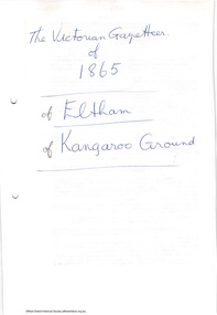 Eltham District Historical Society Inc
Folder, The Victorian Gazetteer of 1865. Entries for Eltham and Kangaroo Ground, 1999
... The Gazetteer is a geographical dictionary or directory for place names in Victoria. ...Eltham District Historical Society Inc 728 Main Rd Eltham melbourne The Gazetteer is a geographical dictionary or directory for place names in Victoria. Entries for Eltham and Kangaroo Ground have been photocopied. ...The Gazetteer is a geographical dictionary or directory for place names in Victoria. Entries for Eltham and Kangaroo Ground have been photocopied. These entries provide physical descriptions, some description of local industry and amenities and more at the time of publication in 1865.3 pages. Copies HG Booklet 118harry gilham collection, gazetteer, eltham, kangaroo ground, 1865 -
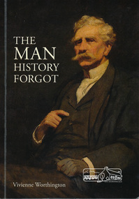 Eltham District Historical Society Inc
Book, The Man history forgot by Vivienne Worthington, 2018
... named for. The cover painting "J.A. Panton, Esq., PM" 1904 is by Frederick McCubbin. Sections in the book refer to : J. A. Panton CMG, Discovery of gold, 1854 Year of Exhibitions, Mining commission, Europe, Bohemia, art and marriage, artist in the western district, patron of Victorian Academy of Art, First Police Magistrate of city court, pioneer pastoralist, aboard the yacht "Cushie Doo", fellow of Royal Geographical Society, London, Inaugural President of Victorian Artists Society, Later Life of Joseph Panton....named for. The cover painting "J.A. Panton, Esq., PM" 1904 is by Frederick McCubbin. Sections in the book refer to : J. A. Panton CMG, Discovery of gold, 1854 Year of Exhibitions, Mining commission, Europe, Bohemia, art and marriage, artist in the western district, patron of Victorian Academy of Art, First Police Magistrate of city court, pioneer pastoralist, aboard the yacht "Cushie Doo", fellow of Royal Geographical Society, London, Inaugural President of Victorian Artists Society, Later Life of Joseph Panton. jospeh anderson panton biography frederick mccubbin cushie doo (ship) gold discovery police magistrate victorian artists society Softcover book The Man history forgot by Vivienne Worthington Book Publishing Productions ...Biography of Goldfields Commissioner Joseph Anderson Panton for whom Panton Hill was named for. The cover painting "J.A. Panton, Esq., PM" 1904 is by Frederick McCubbin. Sections in the book refer to : J. A. Panton CMG, Discovery of gold, 1854 Year of Exhibitions, Mining commission, Europe, Bohemia, art and marriage, artist in the western district, patron of Victorian Academy of Art, First Police Magistrate of city court, pioneer pastoralist, aboard the yacht "Cushie Doo", fellow of Royal Geographical Society, London, Inaugural President of Victorian Artists Society, Later Life of Joseph Panton.Softcover bookjospeh anderson panton, biography, frederick mccubbin, cushie doo (ship), gold discovery, police magistrate, victorian artists society -
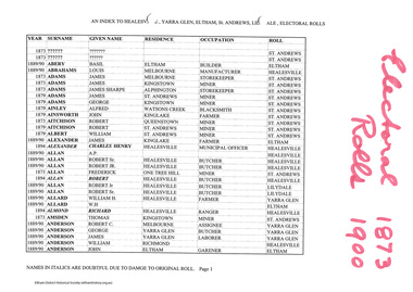 Eltham District Historical Society Inc
Folder, An index to Healesville, Yarra Glen, Eltham, St Andrews, Lilydale, electoral rolls, 1873-1900
... Printed spreadsheet arranged alphabetically by surname, with year, given name, residence, occupation and roll (geographic area) listed....Eltham District Historical Society Inc 728 Main Rd Eltham melbourne Printed spreadsheet arranged alphabetically by surname, with year, given name, residence, occupation and roll (geographic area) listed. Electoral Roll (1873-1900), Harry Gilham Collection, shire of eltham HG Booklet 33 61 pages An index to Healesville, Yarra Glen, Eltham, St Andrews, Lilydale, electoral rolls, 1873-1900 Folder ...Printed spreadsheet arranged alphabetically by surname, with year, given name, residence, occupation and roll (geographic area) listed.61 pagesHG Booklet 33electoral roll (1873-1900), harry gilham collection, shire of eltham -
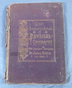 Bendigo Historical Society Inc.
Book - Atlas of Physical Geography
... History House 11 Mackenzie Street Bendigo goldfields Geography Atlas 1871 On first page in pencil the name Carrie Van Damme. ...The student's atlas of physical geography consisting of twenty maps, constructed and engraved by Edward Weller F.R.G.S. with descriptive letterpress by James Bryce L.L.D F.R.G.S. Published by William Collins, Sons & Company, London, Glasgow and Edinburgh 1871. Brown cover with the title of the book in gold letters. to the left of the title, also in gold, three circles with different pictures inside. the first of two boats on the sea, a volcanic eruption and a mountain peak.On first page in pencil the name Carrie Van Damme.geography, atlas, 1871 -
 Bendigo Historical Society Inc.
Book - Geographical dictionary
... Geographic dictionary Colony of Victoria Unreadable name on first page and the name of F. ...The Gazetteer presents an extensive a to z list of Victorian towns and villages, lakes, rivers and creeks, islands, bays, hills and mountains, runs and other localities and features. Entries include latitude and longitude, populations, proximity to other towns, local industries, coach and mail runs, hotels, churches and schools.Bailliere's Victorian Gazetteer and road guide containing the most recent and accurate information as to every place in the colony. Brown hardcover book, on the spine: Victorian Gazetteer with map 1865. The first and last pages are advertisements. The book has 442 pages listing every place in the colony. The map is not included. Compiled by Robert P. Whitworth. Published by Bailliere, Regent Street Unreadable name on first page and the name of F. Houston in blue pen on first page geographic dictionary, colony of victoria -
 Bendigo Historical Society Inc.
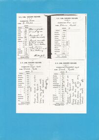
Document - GOLDEN SQUARE LAUREL STREET P.S. COLLECTION: EXAMINATION CARDS
... Each outlines numbered marks out of ten for student named Elaine Rudd for subjects, Reading, Recitation, Spelling, Writing, Composition, English, Arithmetic A-B-C-D, History, Geography, Handwork, Art. ...Each outlines numbered marks out of ten for student named Elaine Rudd for subjects, Reading, Recitation, Spelling, Writing, Composition, English, Arithmetic A-B-C-D, History, Geography, Handwork, Art. ...Four white photocopy examination cards laminated upon blue cardboard and printed, SS 1189 , Golden Square, years 1941-42. Each outlines numbered marks out of ten for student named Elaine Rudd for subjects, Reading, Recitation, Spelling, Writing, Composition, English, Arithmetic A-B-C-D, History, Geography, Handwork, Art. B Rutherford and F Baggaley signatures. Written note states, 'Position; 3rd in class of 45. Excellent result. Elaine has done good work all the year. She seems to be very interested in her school work. Initialled FB.bendigo, institutions, golden square primary school -
 Bendigo Historical Society Inc.
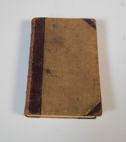
Document - MAJOR MITCHELL AND MOUNT ALEXANDER
... History House 11 Mackenzie Street Bendigo goldfields DOCUMENT Major Mitchell and Mount Alexander Tommy-Came-Last The Major Mitchell Tourist Trail Major General John Byng Phillip of Macedonia Alexander the Great Henty s Surveyor Davidson Alexander Mollison George Augustus Robinson William Morton Mr Charles Hotson Ebden John Randell Public Library of Melbourne Les Blake Governor Burke Phillip Parker King Crown Solicitor Henry Field Gurner Arthur Phillip Hume Australia Felix Expedition L Blake Place Names of Victoria G Brenmer Booklet for Secondary Schools M Cannon Historical Records of Victoria Vol 1 J H L Cumpston Thomas Mitchell Surveyor General and Explorer H F Gurner Chronicle of Port Phillip T L Mitchell Three Expeditions into the Interior of Eastern Australia A F Mollison An Overlanding Diary W L Morton Adventures of a Pioneer M S 5188 Itinerary from the Journal of the Exploring Expedition returning from Portland Bay M S 5189 Mitchell's 1837 Map J O Randell Pastoral Settlement in Northern Victoria Vol 1 Pastoral Settlement in Northern Victoria Vol 2 Records of the Victorian Archaeological Survey Number 5 Journals of George Augustus Robinson T C Sargent Some Peninsular Names in Australia Felix W H Wells A Geographical Dictionary or Gazetteer of the Australian Colonies Typed notes mentioning the naming of Mount Alexander, Coliban, Campaspe and who named them. ...Typed notes mentioning the naming of Mount Alexander, Coliban, Campaspe and who named them. Also the origins of the names.document, major mitchell and mount alexander, tommy-came-last, the major mitchell tourist trail, major general john byng, phillip of macedonia, alexander the great, henty s, surveyor davidson, alexander mollison, george augustus robinson, william morton, mr charles hotson ebden, john randell, public library of melbourne, les blake, governor burke, phillip parker king, crown solicitor henry field gurner, arthur phillip, hume, australia felix expedition, l blake, place names of victoria, g brenmer, booklet for secondary schools, m cannon, historical records of victoria vol 1, j h l cumpston, thomas mitchell surveyor general and explorer, h f gurner, chronicle of port phillip, t l mitchell, three expeditions into the interior of eastern australia, a f mollison, an overlanding diary, w l morton, adventures of a pioneer, m s 5188, itinerary from the journal of the exploring expedition returning from portland bay, m s 5189, mitchell's 1837 map, j o randell, pastoral settlement in northern victoria vol 1, pastoral settlement in northern victoria vol 2, records of the victorian archaeological survey number 5, journals of george augustus robinson, t c sargent, some peninsular names in australia felix, w h wells, a geographical dictionary or gazetteer of the australian colonies -
 Flagstaff Hill Maritime Museum and Village
Book - Reference Book, Mr Salmon (Thomas Salmon) et al, Modern History: or, the Present State of All Nations. Vol III, 1746
... Geographical Part of this Work by Herman Moll. Third Edition with considerable Additions and Improvements, interspersed in the Body of the Work: Also the History and Revolutions of each Country, brought down to the present Time. " Thomas Longman founded his publishing firm in 1724 in London by the name Longman. ...Geographical Part of this Work by Herman Moll. Third Edition with considerable Additions and Improvements, interspersed in the Body of the Work: Also the History and Revolutions of each Country, brought down to the present Time. " Thomas Longman founded his publishing firm in 1724 in London by the name Longman. ...The author was Mr. Salmon (Thomas Salmon), (1679-1788). The fly page of the book has the following writing in red and black print: "Describing their Respective Situations, Persons, Habits, and Buildings; Manners, Laws and Customs, Religion and Policy; Arts and Sciences, Trades, Manufacturers and Husbandry; Plants, Animals and Minerals. Illustrated with Cuts and Maps, accurately drawn according to the Geographical Part of this Work by Herman Moll. Third Edition with considerable Additions and Improvements, interspersed in the Body of the Work: Also the History and Revolutions of each Country, brought down to the present Time. " Thomas Longman founded his publishing firm in 1724 in London by the name Longman. In August of that year, he bought the two shops and goods of William Taylor and set up his publishing house there at 39 Paternoster Row. The shops were called Black Swan and Ship, and it is said that the 'ship' sign was the inspiration for Longman's Logo. After many changes of name and management, including the name T Longman and T Shewell in 1746. The firm was incorporated in 1926 as Longmans, Green & Co. Pty Ltd. The firm was acquired by Pearson in 1968 and was known as Pearson Longman or Pearson PLC. The book is part of Flagstaff Hill's Pattison Collection, a large group of books and records, some of which are rare and valuable. The collection was originally owned by the Warrnambool Mechanics' Institute, which was founded in 1853 and is named after Warrnambool's Public Librarian, Ralph Pattison.The book is significant for its age – it is one of the oldest books in Flagstaff Hill’s collection, published in 1746. The book is a record of Modern History at that time and allows studying and comparing those times with today. The book is important for its connection with the London publisher T Longman and T Sewell, who only operated under this name between 1745 and 1747. The firm has been established for over two centuries and is renowned for publishing encyclopedias, dictionaries, books on English grammar, textbooks, poetry, reference books, novels, magazines and more. The book has additional importance for its connection to the Pattison Collection, which, along with other items at Flagstaff Hill Maritime Village, was originally part of the Warrnambool Mechanics' Institutes’ Collection. The Warrnambool Mechanics’ Institute book collection has historical and social significance for its strong association with the Mechanics Institute movement and its important role in people's intellectual, cultural and social development throughout the latter part of the nineteenth century and the early twentieth century. The collection of books is a rare example of an early lending library and its significance is enhanced by the survival of an original collection of many volumes. The Warrnambool Mechanics' Institute’s publication collection is of both local and state significance.Modern History: or, the Present State of All Nations Vol III Author: Mr. Salmon (Thomas Salmon) Illustrator: Herman Moll Publisher: T Longman and T Shewell in Paternoster Row, London Date: 1746 (MDCCXLVI), 3rd Edition Further Information: In Three Volumes, Vol. III The large hardcovered book has reinforcing on the spine and corners. The cover is very well worn and has remnants of a coloured design. The fly page is printed in red and black ink and has a long description of the contents. Inside the cover is printed a Coat of Arms. There is a stocker on the inside cover, The book is part of the Pattison Collection.Label on the spine "RH F910 SAL" Sticker on the pastedown front endpaper "Corangamite Regional Library Service" Printed on pastedown front endpaper "Coat of arms, crown above a shield with an inverted V with three stars on it" Sticker on front loose endpaper "Coat of arms, with "F C G Ritso"flagstaff hill, flagstaff hill maritime museum and village, warrnambool, maritime museum, maritime village, great ocean road, shipwreck coast, pattison collection, ralph eric pattison, warrnambool mechanics’ institute, mechanics’ institute library, warrnambool library, free library, corangamite regional library service, mr salmon, thomas salmon, 18th century, 1746, history, geography, social studies, culture, maps, modern history, present state of all nations vol iii, herman moll, t longman and t shewell, social history -
 Flagstaff Hill Maritime Museum and Village
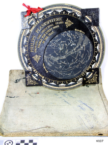
Planisphere, Early 20th Century
... name "Planisphere" was made in 1624 by Jacob Bartsch. Bartsch was the son-in-law of Johannes Kepler, discoverer of Kepler's laws of planetary motion. A significant item of celestial mapping used by marine navigators This particular item was made and used in the first quarter to half of the 20th century flagstaff hill warrnambool shipwrecked-coast flagstaff-hill flagstaff-hill-maritime-museum maritime-museum shipwreck-coast flagstaff-hill-maritime-village planisphere star map marine navigation maps george philip & sons "Made in Germany for GEORGE PHILIP & SONS Ltd. Geographical ...The word Planisphere (Latin planisphaerium) was originally used in the second century by Claudius Ptolemy to describe the representation of a spherical Earth by a map drawn in the plane. This usage continued into the Renaissance: for example Gerardus Mercator described his 1569 world map as a Planisphere. The word describes the representation of the star-filled celestial sphere on the plane. The first star chart to have the name "Planisphere" was made in 1624 by Jacob Bartsch. Bartsch was the son-in-law of Johannes Kepler, discoverer of Kepler's laws of planetary motion. A significant item of celestial mapping used by marine navigators This particular item was made and used in the first quarter to half of the 20th centuryPlanisphere of northern hemisphere, with canvas bag. Planisphere consists of a circular star chart attached at its centre to an opaque circular overlay that has a clear elliptical window or hole so that only a portion of the sky map will be visible in the window or hole area at any given time. The chart and overlay are mounted so that they are free to rotate about a common pivot point at their centres. The star chart contains the brightest stars, constellations and (possibly) deep-sky objects visible from a particular latitude on Earth. The night sky that one sees from the Earth depends on whether the observer is in the northern or southern hemispheres and the latitude. A Planisphere window is designed for a particular latitude and will be accurate enough for a certain band either side of that. Planisphere makers will usually offer them in a number of versions for different latitudes. Planispheres only show the stars visible from the observer's latitude; stars below the horizon are not included. A complete twenty-four-hour time cycle is marked on the rim of the overlay. A full twelve months of calendar dates are marked on the rim of the starchart. The window is marked to show the direction of the eastern and western horizons. The disc and overlay are adjusted so that the observer's local time of day on the overlay corresponds to that day's date on the star chart disc. The portion of the star chart visible in the window then represents (with a distortion because it is a flat surface representing a spherical volume) the distribution of stars in the sky at that moment for the Planispheres designed location. Users hold the Planisphere above their head with the eastern and western horizons correctly aligned to match the chart to actual star positions. "Made in Germany for GEORGE PHILIP & SONS Ltd. Geographical and Educational Depot, 32 Fleet Street, London" Canvas bag has "Capt. H (Howard) Tyler from Captain H. F. Woolf" "Tyler 22 ? St East Brighton" also "13 Halls St Flinders"flagstaff hill, warrnambool, shipwrecked-coast, flagstaff-hill, flagstaff-hill-maritime-museum, maritime-museum, shipwreck-coast, flagstaff-hill-maritime-village, planisphere, star map, marine navigation, maps, george philip & sons -
 Greensborough Historical Society
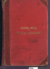
Book, W. & A.K. Johnston, School atlas of physical geography: the elementary facts of geology; hydrography; meteorology and natural history by Alex Keith Johnston, 1871_
... This volume illustrates a 19th century view of physical geography. physical geography school books atlases Inscribed on fly leaf with original owner's name (1890) 51 pages, 20 plates, maps. ...This atlas of physical geography has 20 plates illustrating maps and various rock formations.This volume illustrates a 19th century view of physical geography.51 pages, 20 plates, maps. Red hard cover with title in gold lettering.Inscribed on fly leaf with original owner's name (1890)physical geography, school books, atlases -
 Flagstaff Hill Maritime Museum and Village
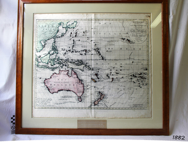
Map, Australien (Sudland) auch Polynesien oder Inselwelt, insgemein der funfte Welltheil, c.1990
... This reprint of an 1802 is significant for its historical and geographical contant, showing the voyages of many early explorers to the southern regions of the world including Australia. It also shows the early names ...This map is a reprint of Johann (Johannes) Walch’s “Australien (Sudland) auch Polynesien oder Inselwelt, insgemein der funfte Welltheil”, published in 1802. It shows Australia, New Zealand, South East Asia and the Pacific Islands shows a large number of places names, many of which have changed since the map was drawn. The map includes the routes and dates of the voyages of Tasman, Cook, Bougainville, Carteret, Byron, and others up to 1802. The shapes of the lands on this early map show that some of the areas had not yet been charted. The map was donated to Flagstaff Hill Maritime Village in April 1990 by the Group Study Exchange Team from Rotary District 233, Sweden. It was framed and presented by Rotary District 978 and presented by Barry Lange, the Governor of District 978 in 1989-90. (District 978, Geelong East, is now District 9780.) Johann (Johannes) Walch Johann Walch, painter and engraver, was born in 1757. He was well known for creating miniature portraits. He gained his training in Geneva, Venice and Rome. His publications include atlases and sheet maps, many of which were reprinted after his death in 1816. This reprint of an 1802 is significant for its historical and geographical contant, showing the voyages of many early explorers to the southern regions of the world including Australia. It also shows the early names used for countries and towns and is a valuable reference to historical interpretation. The map itself is a fine example of hand drawn and hand coloured maps of the early 19th century, the method of production, detail included, layout, symbols and so forth.Map, reprint of Johann (Johannes) Walch’s “Australien (Sudland) auch Polynesien oder Inselwelt, insgemein der funfte Welltheil “, first published by in Ausburg in 1802. The image on this Map No 5B, shows Australia and the south Pacific. The timber framed, glass covered, printed and coloured map was created in two sections and joined. Brass plaque at base of map states that the map was presented to Flagstaff Hill by Rotary International in April 1990. Feint lines used for aligning lettering can be seen on the map and there are large erased letters such as a “D” and “S” that are almost obscured.Plague “ROTARY INTERNATIONAL / THE MAP WAS DONATED BY THE GROUP STUDY EXCHANGE TEAM / FROM ROTARY DISTRICT 233 SWEDEN IN APRIL 1990 / AND WAS FRAMED AND PRESENTED BY ROTARY DISTRICT 978 / BARRY LANGE – GOVERNOR DISTRICT 978 1989/90” Stamped on back “ELLIMINOOK FRAMES / MRS. JILL FALKINER / ELLIMINOOK / BIRREGURRA, VIC. 3242 / PHONE: (052) 36 2080” flagstaff hill, warrnambool, shipwrecked coast, flagstaff hill maritime museum, maritime museum, shipwreck coast, flagstaff hill maritime village, great ocean road, australien (sudland) auch polynesien oder inselwelt, insgemein der funfte welltheil, johann (johannes) walch, cartographer johann (johannes) walch, ausburg publisher johann (johannes) walch, johann (johannes) walch map number 5b, 1802 map of australia and south pacific, rotary international group study exchange team, rotary district 233 sweden, elliminook frames, voyages of tasman, voyages of cook, voyages of bougainville, voyages of carteret, voyages of byron, barry lange, painter of miniature portraits johann (johannes) walch