Showing 1984 items matching "glen eira rd"
-
 Glen Eira Historical Society
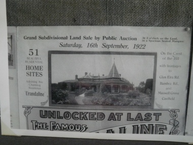
Historical Caulfield to 1972, photo album by Jenny O’Donnell, Glen Eira Rd
... Historical Caulfield to 1972, photo album by Jenny O’Donnell, Glen Eira Rd......Glen Eira Rd...Glen Eira Historical Society 965 Glen Huntly Rd Caulfield VIC 3162 melbourne Elsternwick Glen Eira Rd Uraldine Edwardian houses Houses Caulfield Town Hall O’Donnell Jenny Prints of 4 extracts re sale of Uraldine 1922, Caulfield Town Hall also pictured Historical Caulfield to 1972, photo album by Jenny O’Donnell, Glen Eira Rd ...Prints of 4 extracts re sale of Uraldine 1922, Caulfield Town Hall also picturedelsternwick, glen eira rd, uraldine, edwardian houses, houses, caulfield town hall, o’donnell, jenny -
 Glen Eira Historical Society
Article - Glen Eira Parks and Gardens
... Glen Eira Council... Hawthorn Rd...Glen Eira Historical Society 965 Glen Huntly Rd Caulfield VIC 3162 melbourne This file contains four items. 1/ An article in the Glen Eira News reporting on a new park with indigenous planting and an interpretive walk being developed to link Duncan McKinnon Reserve and Packer Park in Murrumbeena, dated September 2000. 2/ An article from the Glen Eira Leader on the converting of sports grounds from cool season to warm season grasses, as well as the installation of subsurface drip irrigation at Princes Park, Caulfield South, dated March 2012. 3/ An article from the Caulfield/Port Phillip leader reporting Caulfield RSL military historian Carl Johnson’s appeal to have a “lone pine” in Caulfield Park designated as a war memorial, dated 11/9/2012 4/ An article from the Glen Eira/Port Phillip Leader reporting on the Friends of Caulfield Park organising the first band stand concert in over twenty years with the City of Glen Eira Band, dated 6/11/2012 Glen Eira Council Hawthorn Rd Caulfield Glen Eira Rd Caulfield Glen Eira Caulfield Parks Reserves Leila Rd Caulfield Glen Eira City Council Landscaping Memorial Park Kooyong Rd Caulfield North Caulfield Recreation Tennis Club Murrumbeena Rd Caulfield Churchill Green housing estate North Rd Caulfield Boake Street Caulfield Exservices organisation RSL Clubs Sporting Clubs Recreations Sportsgrounds Clubs Tennis Clubs Associations Leisure Cultural Events Cultural Activities Sports Establishments Recreations Establishments Irrigation Water Conservation Conservation of Natural Resources Water Supply Ovals Playing fields Tennis Courts Murrumbeena Park School Concerts Musical Activities Musical Events Glen Eira Artists society DiMarco Lisa St. ...This file contains four items. 1/ An article in the Glen Eira News reporting on a new park with indigenous planting and an interpretive walk being developed to link Duncan McKinnon Reserve and Packer Park in Murrumbeena, dated September 2000. 2/ An article from the Glen Eira Leader on the converting of sports grounds from cool season to warm season grasses, as well as the installation of subsurface drip irrigation at Princes Park, Caulfield South, dated March 2012. 3/ An article from the Caulfield/Port Phillip leader reporting Caulfield RSL military historian Carl Johnson’s appeal to have a “lone pine” in Caulfield Park designated as a war memorial, dated 11/9/2012 4/ An article from the Glen Eira/Port Phillip Leader reporting on the Friends of Caulfield Park organising the first band stand concert in over twenty years with the City of Glen Eira Band, dated 6/11/2012glen eira council, hawthorn rd caulfield, glen eira rd caulfield, glen eira, caulfield, parks, reserves, leila rd caulfield, glen eira city council, landscaping, memorial park, kooyong rd caulfield north, caulfield recreation tennis club, murrumbeena rd caulfield, churchill green housing estate, north rd caulfield, boake street caulfield, exservices organisation, rsl clubs, sporting clubs, recreations, sportsgrounds, clubs, tennis clubs, associations, leisure, cultural events, cultural activities, sports establishments, recreations establishments, irrigation, water conservation, conservation of natural resources, water supply, ovals, playing fields, tennis courts, murrumbeena park, school concerts, musical activities, musical events, glen eira artists society, dimarco lisa, st. aloysius college, band rotundas, entertainment structures, musical ensembles, city of glen eira band, bands, the friends of caulfield park, gallipoli lone pine, princes park, packer park, duncan mckinnon reserve, king george reserve, caulfield park, glenhuntly park, glen huntly park, bentleigh reserve, victory park, schools, education establishments, recycling, water disposal, cultural structures, cultural establishments, caulfield rsl, johnson carl, war memorials, monuments, memorials, avenue of honour, “lone pine”, glen eira leader, glen eira news, caulfield/port phillip leader, glen eira leader -
 Glen Eira Historical Society
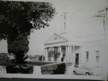
Historical Caulfield to 1972, photo album by Jenny O’Donnell, Hawthorn Rd
... ...Glen Eira Rd...Glen Eira Historical Society 965 Glen Huntly Rd Caulfield VIC 3162 melbourne Caulfield South Glen Eira Rd Hawthorn Rd Caulfield Town Hall O’Donnell Jenny 5 photos of Caulfield Town Hall 1972 Historical Caulfield to 1972, photo album by Jenny O’Donnell, Hawthorn Rd ...5 photos of Caulfield Town Hall 1972caulfield south, glen eira rd, hawthorn rd, caulfield town hall, o’donnell, jenny -
 Hume City Civic Collection
Photograph, Circa 1916
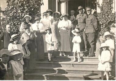
... Handwritten on back: VISIT OF RED CROSS AT RUPERTSWOOD Stamped on back: FROM F.W. TOLRA / 79 GLEN EIRA RD /RIPPON LEA...Hume City Civic Collection 44 Macedon Street Sunbury melbourne red cross rupertswood community activities george evans collection Handwritten on back: VISIT OF RED CROSS AT RUPERTSWOOD Stamped on back: FROM F.W. TOLRA / 79 GLEN EIRA RD /RIPPON LEA A b/w photograph of a community activity showing the visit of the Red Cross at Rupertswood. ...A b/w photograph of a community activity showing the visit of the Red Cross at Rupertswood.Handwritten on back: VISIT OF RED CROSS AT RUPERTSWOOD Stamped on back: FROM F.W. TOLRA / 79 GLEN EIRA RD /RIPPON LEAred cross, rupertswood, community activities, george evans collection -
 Glen Eira Historical Society
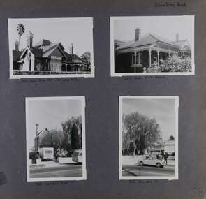
Album - Album page, Glen Eira Road, Circa 1972
... Hand written: Glen Eira Road [top right] / 105 Glen Eira Rd 3rd July 1972 [under top left photo] / 245 Glen Eira Road [under top right photo] / 356 Glen Eira Road [under bottom left photo] / 356 Glen Eira Rd [under bottom right photo] / 58 [bottom right] ...All photographs are black and white except where stated, with 386 photographs over 198 pages. trevor hart glen eira road caulfield north victorian streetscape cars verandahs Hand written: Glen Eira Road [top right] / 105 Glen Eira Rd 3rd July 1972 [under top left photo] / 245 Glen Eira Road [under top right photo] / 356 Glen Eira Road [under bottom left photo] / 356 Glen Eira Rd [under bottom right photo] / 58 [bottom right] Page 58 of Photograph Album with four photographs of three different properties on Glen Eira Road. ...This photograph is part of the Caulfield Historical Album 1972. This album was created in approximately 1972 as part of a project by the Caulfield Historical Society to assist in identifying buildings worthy of preservation. The album is related to a Survey the Caulfield Historical Society developed in collaboration with the National Trust of Australia (Victoria) and Caulfield City Council to identify historic buildings within the City of Caulfield that warranted the protection of a National Trust Classification. Principal photographer thought to be Trevor Hart, member of Caulfield Historical Society. Most photographs were taken between 1966-1972 with a small number of photographs being older and from unknown sources. All photographs are black and white except where stated, with 386 photographs over 198 pages. Page 58 of Photograph Album with four photographs of three different properties on Glen Eira Road.Hand written: Glen Eira Road [top right] / 105 Glen Eira Rd 3rd July 1972 [under top left photo] / 245 Glen Eira Road [under top right photo] / 356 Glen Eira Road [under bottom left photo] / 356 Glen Eira Rd [under bottom right photo] / 58 [bottom right] trevor hart, glen eira road, caulfield north, victorian, streetscape, cars, verandahs -
 Melbourne Tram Museum
Magazine, Glen Eira Historical Society, "Glen Eira Historical Society Newsletter", Sep. 2014
... Glen Eira... McKinnon Rd...Melbourne Tram Museum 8 Wallen Road Hawthorn melbourne Trams tramways Caulfield Horse Trams Glen Eira McKinnon Rd Parts OF the Glen Eira Historical Society Newsletter" for September 2014 with items on the McKinnon Road shopping centre, a report on a talk by Ian Jenkin of the ARHS Vic Div about the Caulfield horse tramway and the PMTT and a report of a walk along the horse tram route conducted by Peter Carwardine of the ARHS in July 2014. ...Parts OF the Glen Eira Historical Society Newsletter" for September 2014 with items on the McKinnon Road shopping centre, a report on a talk by Ian Jenkin of the ARHS Vic Div about the Caulfield horse tramway and the PMTT and a report of a walk along the horse tram route conducted by Peter Carwardine of the ARHS in July 2014. Includes a donation note from Member Keith Stodden, dated 25-9-2014trams, tramways, caulfield, horse trams, glen eira, mckinnon rd -
Glen Eira Historical Society
Document - Seymour Road, 67, Elsternwick
... ... Glen Eira Road... Orrong Rd...Seymour Road Elsternwick Beemery Park Glen Eira Road Orrong Rd Allison Rd Kooyong Rd Beemery Langdon Charles Rosecraddock Park St Nelson Annie Mills Eva Symon Synot Callarhan Margaret Peterson Alexander Peterson DM Bullock Hilary Landells Rosemary Document Seymour Road, 67, Elsternwick ...One typed and one handwritten document on 67 Seymour Road. Document details owners/tenants from 1919 to 1974 and brief history on subdivision from Brighton Historical Society.seymour road, elsternwick, beemery park, glen eira road, orrong rd, allison rd, kooyong rd, beemery, langdon charles, rosecraddock, park st, nelson annie, mills eva, symon synot, callarhan margaret, peterson alexander, peterson dm, bullock hilary, landells rosemary -
Shelford Girls' Grammar
Tie Pin, Stokes, 1922-1955
... The school was closely linked to St Mary's Church of England, Glen Eira Rd, Caulfield, Victoria. The badge was designed by Canon Langley and Mr. ...The school was closely linked to St Mary's Church of England, Glen Eira Rd, Caulfield, Victoria. The badge was designed by Canon Langley and Mr. ...This tie pin features the school crest used by Shelford Girls Grammar during the period 1922-1955 when the school was known as a Church of England Girls Grammar School. The school was closely linked to St Mary's Church of England, Glen Eira Rd, Caulfield, Victoria. The badge was designed by Canon Langley and Mr. W.E.L. Wears in 1922 when the school was taken over by the Church of England. The motto means "Seek Ye First the Kingdom of God."This tie pin is representative of tie pins worn by all students at Shelford C.E.G.G.S during the period 1922-1955. It forms an official part of the school uniform at that time. Metal tie pin featuring the crest of Shelford Church of England Grammar School. The crest is silver and dark royal blue and features a large silver "S" in the centre of a blue oval. The oval features the words "Querite Primo Regnum Dei. St Mary's C of E". A banner underneath reads "CAULFIELD" .STOKES stamped on reverseshelford, shelford church of england girls grammar school, shelford girls grammar, st. mary's, church of england, canon langley, w. e. l. wears -
 Yarra Ranges Regional Museum
Brassiere
... Zilpah, known as Win, married Harold Stewart (Bill) Carroll on Dec 21, 1938 at St MAry's Anglican Church on Glen Eira Rd, Caulfield. The Carrolls moved to Belgrave with their children in 1954 and lived there for over 40 years. ...Zilpah, known as Win, married Harold Stewart (Bill) Carroll on Dec 21, 1938 at St MAry's Anglican Church on Glen Eira Rd, Caulfield. The Carrolls moved to Belgrave with their children in 1954 and lived there for over 40 years. ...This Brassiere belong to Mrs Zilpah Winifred Carroll (nee Parker) (1914 - 2001) and formed part of her trousseau. Zilpah, known as Win, married Harold Stewart (Bill) Carroll on Dec 21, 1938 at St MAry's Anglican Church on Glen Eira Rd, Caulfield. The Carrolls moved to Belgrave with their children in 1954 and lived there for over 40 years. Zilpah was supposed to be names "Zilpha" after a fictional heroine, however her father misspelled the name on her birth certificate. Cream lace bra with elastic and ribbon shoulder straps, two buttons to stretch and fasten at front. -
 Ballarat Tramway Museum
Postcard, ESCo tram at the east end of Sturt St
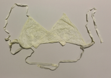
... Recipient - Mr. A. Steer, Glen Eira Rd. Elsternwick. Has a Ballarat Post office and stamp and Victorian 1d stamp (red). ...Recipient - Mr. A. Steer, Glen Eira Rd. Elsternwick. Has a Ballarat Post office and stamp and Victorian 1d stamp (red). ...B&W postcard of an ESCo tram at the east end of Sturt St. Ballarat, with the Grenville St. shelter in the background. Shows buildings along both sides of Sturt St. Has a few pedestrians in the photo and some horse drawn vehicles in the background. Tram in style with destination box/lights at back of drivers canopy. Has title "Sturt Street - looking West, Ballarat" in top left hand corner. On rear "H.J. Summerscales, next Post Office, Ballarat - Printed in Germany" on left hand edge vertically. Post card dated 29/12/10 (1910), from E.H. Colson? at 49 Webster St. wishing the recipient a happy new year. Recipient - Mr. A. Steer, Glen Eira Rd. Elsternwick. Has a Ballarat Post office and stamp and Victorian 1d stamp (red). As well in pencil, a price "$15". See also scanned image file and prints from negative at Reg. Item 833. Image cropping is slightly different at the bottom to that of Reg. Item 833. Used in postcard display 2017-2018trams, tramways, esco, sturt st, postcards -
 Melbourne Tram Museum
Letter - Correspondence, Melbourne & Metropolitan Tramways Board (MMTB), "Trolley Buses", 1922-36
... Has been damaged. 3/2/1926 Letter from Bruce Henderson re transport in the Glen Eira Rd area – poor private bus. 25/10/1925 Letter to G. ...Has been damaged. 3/2/1926 Letter from Bruce Henderson re transport in the Glen Eira Rd area – poor private bus. 25/10/1925 Letter to G. ...File containing correspondence between the MMTB Chief Engineer Mr. Strickland and various companies, including Railless Ltd, Australian General Electric, English Electric / Dick Kerr and its UK consultants Heap and Digby (H&D) between the period August 1922 and August 1936. Includes drawings, technical specifications, some of which are duplicated in the Reg Item 535 file. For a listing of the contents of this file and of Reg Item 535, see Related Documents - htd535-536list.pdf Item 536 - Trolley Buses Listed from top of file, in order found. Letters generally to/from MMTB Chief Engineer. Date Type Notes 7/8/1936 Letter from TE Barnes – re Bremen Germany Steam Omnibus. Three pages. On foolscap paper – rest quarto. Has been damaged. 3/2/1926 Letter from Bruce Henderson re transport in the Glen Eira Rd area – poor private bus. 25/10/1925 Letter to G. Higgins, regarding a paper he had presented and printed in Australian Municipal Journal about transport around Melbourne, predicted the demise of trams, trains. Notes Spencer St bridge. Copy of paper is pinned with letters. 28/819/22 Copy of letter to H&D from AEC (see above) Includes the Mexborough test gradient drawing. Undated Pamphlet from Railless Limited about Birmingham’s new trolley buses. 16/3/1923 Extract from Electric Railway and Tramway Journal – wages of trolleybus drivers not getting paid extra in Bradford. Two copies pinned together. 9/4/1923 Letter from H&D re pamphlet exchange You should have had it! 23/2/1923 Letter to H&D asking for information. Has a note re the Board’s attitude towards motor buses. 28/8/1922 to 24/23 Series of letters pinned together with L. de Koenneritz regard trolley buses and Paris. Noted that the MMTB did not have the legislative power to run trolley buses. 15/2/1922 to 10/4/23 Series of letters pinned together with the Aust. GE regarding trolley buses and references to their operation in journals. 10/1/1923 Letter from H&D re request for information on driving gear of Railless Ltd. vehicles 23/2/1923 Letter to H&D re above. 23/2/1923 Sheet of paper on “Steads Review” paper – pamphlet not yet to hand. 8/11/1922 to 10/1/1923 Series of letters with H&D pinned together asking for Railless driving gear – reluctant to provide. 26/9/1922 Letter from H&D, with copy of letter from English Electric enclosing materials regarding Trolley Bus equipment. Note much of this material is the same as that in Reg Item 535 contained within the green cloth tape. Performance curves for DK 26B motor Blueprint – 4449 – outline of controller DK, Type D, form B. Specification for DK 26B trolley motor. Blueprint – drawing 2810 – DK 26 Motor Blueprint – No. 1312D – controller diagram Pamphlet – EE – tramcar Type D automatic circuit Breakers. Publication No. 230, dated 9/1920. Ditto, Form A, drawings No 3565, 1/1/19. Performance curves for DK85A motor Blueprint – P2002M034 – DK85 Motor. EE specification for Traction Motor DK85 Modified from a tram motor. Blueprint – EE drawing – P2002M036 – DK85 motor with ball bearings. EE blueprint P2102F021, traction control wiring for form D controller. EE blueprint P2103F033 – outline of controller type SE1, form C and D. EE blueprint P2102Z011 – wiring diagram for type SE1 form controller. EE blueprint – P2102F025 – diagram of connections (wiring) for Type SE1, form D controller.trams, tramways, trolley buses, melbourne, mmtb, aec, heap and digby, english electric, railless, dick kerr, general electric -
Glen Eira Historical Society
Book - Ormond Amateur Football Club
... Glen Eira Historical Society 965 Glen Huntly Rd Caulfield VIC 3162 melbourne This file contains two items: 1/A 50 page book on history of Ormond Junior Football Club, from its days as St. ...This file contains two items: 1/A 50 page book on history of Ormond Junior Football Club, from its days as St. Annes Football Club to its amalgamation with Ormond Amateur Football. Book compiled by Claire Barton from AGM meetings 2009. 2/A copy of six football club addresses from the city of Moorabbin Community Directory 1987.ormond junior football club, stock jack, stevens harold r., st. annes church hall, halls, maylan street, east bentleigh, bentleigh mckinnon youth club, clubs and associations, smith brian, scott r. ken, steve stevens, keane adrian, oaten max, dight john, southam david, patterson don, stait ron, ceresa jack, forward cyril, moorehouse bob, forward may, heggert joan, morris jill, brabner martene, williams margaret, jackson judy, mcinery loris, mckinnon high school, walnut street, bailey reserve, boundary road, dowling russell, miller ian, keane david, starke neil “speedie.”, red cross, schweppes, sponsors, claremont junior football club, glenorchy football club, hudson peter, heggert keith, hilton ken, ormond blues, barassi ron, dargavel marita, beggs mr., smith mr., kaighal mr., gunn e. e., morcum glen, cochrane b., clark d., tate geoff, dargavel b., pappas sid, melbourne football club, brabner cameron, siderellis terry, morris wayne, burns robbie, kemp malcolm, siderellis tim, tinsley warwick, grant tom, middleton mick, dowling ian, clarke grant, young morgan, dawes bernie, dawes gerry, montgomery peter, peebles gordon, bentleigh bulldogs football club, mckinnon reserve, sheehy marnie, doble john, kerford phil, gleeson ian, rollasom brian, beynon wayne, societal events and activities, sheehy fay, wood ron, mckinnon butchers, brabner graham, begg john, moorabbin ufa, melbourne football club little league, interleague football matches, brandella cup, mccarthy justin, lough chris, montgomery stephen, carey tim, roe anthony, hardy chris, mccarthy justin, thomas matthew, perry richard, birch david, king denise, sparrow family, wilson ron, dupe stephen, karrageorgiov chris, hardy chris, borrett john, edgells darren, sparrow peter, ormond amateur football club, duncan john, beard j., warren e., pearson martin, waldron gary, marwood shane, collingwood vfl, jackson ricky, melbourne vfl, smith terry, richmond vfl, perkin phil, bentleigh juniors, beham m., neville david, taylor stephen, palmer tony, o’hara matt, ‘the cedric keane perpetual trophy’, st. anne’s football club, ormond east, valkstone, glenhuntly, st. patricks, primary schools, st. kilda junior leagues, lightening premiership, measures paul, msjfl u15 best and fairest, birch david, eishold lewis, eishold rohan, murrumbeena j. f. club, vic kick clinic, lough david, pennacchia luigi, best and fairest, buckley mark, rombotis john, d’astoli michael, msjfl team, king geoff, stumbles roger, williams cameron, byron noel, gillot heather, lehner elaine, oakleigh districts, stevens h. r., forward c. c., beggs j. w., scott k. k., kaighan t. a., dargavel m. mrs., forward n. c., keane m. j. mrs., woodhouse r. j. (dec), smith b. w., keane c. b., morgom g. m. (dec), dowling r. a., starke n., montgomery p., pearson p., kerford p., king d. mrs., lough d., perkin p., lehner e. mrs., russell r., interleague team, byron jason, guzzo anthony, kinsella trent, pym dominic, turner davis, b. f., artz ben, ralogaivav joe, jones alan, martin rick, editor, barton claire, australian rules football, sporting clubs, ormond, mckinnon, bentleigh, sports officials, committees of management, murrumbeena -
Glen Eira Historical Society
Article - Ormond Amateur Football Club
... Glen Eira Historical Society 965 Glen Huntly Rd Caulfield VIC 3162 melbourne Four items on Ormond Junior Club: 1/One item from Glen Eira Leader, dated c.2009, on winning teams for season 2009. 2/One item on Ormond Auskick parent information night, dated 20/04/2011, from Melbweekly Bayside.. 3/One item on Sam Frost, player. ...Four items on Ormond Junior Club: 1/One item from Glen Eira Leader, dated c.2009, on winning teams for season 2009. 2/One item on Ormond Auskick parent information night, dated 20/04/2011, from Melbweekly Bayside.. 3/One item on Sam Frost, player. Includes photograph. Also from Melbweekly Bayside. 4/Ormond News printout, June edition 2013.ormond junior football club, ‘monders’, moorabbin saints, sherman andrew, wood matthew, hille tim, higgins jack, capicciano michael, johnson roland, kerstens marlon, artz ben, anastasio anthony, davies jordan, parne nick, houghton nick, ormond’s auskick, e. e. gunn reserve, malane street, ormond, frost sam, ormond blues, ormond, johnson belinda, rolfe kerri, president, seaton anthony, nille jackson, smyth harry, trusler aaron, burt herrison, hayward reuben, green max, hankin spencer, johnson emma, nash will, harty joel, spackman darcy, teihrintzis nathaniel, holdring liam, cavey will, mcgrath nicholas, pvin hugh, pekaj paul, matthews darcy, cooke sam, forest pat, northey chris, sutherland noah, sporting clubs, australian rules football, sports officials, atkinson jack, mizrahi ben, clarkson matthew, seemen chris, seemen james, marlow toby, lovett ethan, doherty conor, smith millie, marlaw sharon, mahon sam, urban magnus, steele david, mcquie, urban michael, mccambley garry, mclaren greg, phillips louis, harte george, leontaritis george, mcleod matthew, forrest pat, bernes sam, cove mick, defegely james, barnes tim, tabakman jordan, tahana izzy, hemming lucas, jordan matt, hardwick bj, gurevich yasha, mccambley jack, mason sam, landman james, martin rick -
Glen Eira Historical Society
Article - Ormond Amateur Football Club
... Glen Eira Historical Society 965 Glen Huntly Rd Caulfield VIC 3162 melbourne This file contains 4 items about Ormond Club Members: 1/Article from Leader newspaper, dated 22/06/2010, about Demetrios Stoupas winning a Glen Eira Council Volunteer award. 2/Photocopied article from Leader newspaper, dated 30/03/2013, about former Ormond player David Chisholm. 3/Memorial Service, dated 28/07/2010, for Justin Harte, Ormond Junior Club Team manager. 4/Flyer and article from the Herald Sun, dated 24/06/2012, about Zaidee Turner, ex-player for Ormond Junior Football Club. ...This file contains 4 items about Ormond Club Members: 1/Article from Leader newspaper, dated 22/06/2010, about Demetrios Stoupas winning a Glen Eira Council Volunteer award. 2/Photocopied article from Leader newspaper, dated 30/03/2013, about former Ormond player David Chisholm. 3/Memorial Service, dated 28/07/2010, for Justin Harte, Ormond Junior Club Team manager. 4/Flyer and article from the Herald Sun, dated 24/06/2012, about Zaidee Turner, ex-player for Ormond Junior Football Club.stoupas demetrios, bentleigh, mckinnon basketball association, ormond football club, ormond auskick, moorabbin saints junior football league, ormond junior football club, sporting clubs, chisholm david, mixed netball championships, chisholm john, president, harte justin timothy, turner zaidee, turner allan, turner kim, zaidees rainbow foundation, clubs and associations, ormond, australian rules football, voluntary workers, charitable organisations, sports officials -
Glen Eira Historical Society
Document - Ormond Amateur Football Club
... Glen Eira Historical Society 965 Glen Huntly Rd Caulfield VIC 3162 melbourne This file contains one item: 1/A 42 page printed Ormond Junior Football Club 2010 Annual Report. ...This file contains one item: 1/A 42 page printed Ormond Junior Football Club 2010 Annual Report. The report covers Life Members, Premierships, committee, coaches and team managers, reports from the President and treasurer, property, social, medical and Auskick and Fair Go Footy. Also a report on every team.ormond junior football club, rolfe kerri, president, harkin tim, vice president, naylor alan, secretary, treasurer, scanlan greg, committees of management, barton claire, bisognim livio, harty scott, harms hans w., houghton bruce, macri christine, murray gary, raymond david, sherman andrew, johnson belinda, robinson jenny, harms fran, adlington sue, clubs and association, sporting clubs, sports officials, australian rules football, annual reports -
Glen Eira Historical Society
Book - Ormond Amateur Football Club
... Glen Eira Historical Society 965 Glen Huntly Rd Caulfield VIC 3162 melbourne This file contains 2 items: 1/An 83 page book titled ‘The First Fifty Years. ...This file contains 2 items: 1/An 83 page book titled ‘The First Fifty Years. Ormond Amateur Football Club.’ The book details why it was written and by whom. It then goes on to describe the playing years from 1931-1981, missing the 6 years from 1940-1946 during WWII. Includes 11 photographs, Presidents’ history, captains and Premiership coaches, Best and fairest winners, life members. 2/A responsible drinking poster distributed in 2013.ormond amateur football club, burdekin e., donaldson e., foulsham c., kingston j., rowe g., scott d., sheehan j., bray j., dart s., godfredson r., hassed m., johnston m., yewdall m., dalton fine paper, sponsors, berby graham, typographical services pil, ashley ray, ashley dean pic, the campaign palace, peterson janis, hall tony, rankine chris, harris geoff, moran g. f., lacey scott, victorian amateur football association, districtclub, smith l. e., president, organizations, sporting clubs, emblems, sports, uniforms, johnson alex, ormond park, smith mr., stevens mr., gunn e. e., elliston mr., hogan mr., coffey mr., skates mr., gymnasiums, jasper road, junior club, smith east suburban football league, ormond junior football club, kingston jack, australian rules football, football clubs, sports officials, clubs and associations -
Glen Eira Historical Society
Document - Ormond Amateur Football Club
... Glen Eira Historical Society 965 Glen Huntly Rd Caulfield VIC 3162 melbourne This file contains 2 items: 1/An article from the website of the Southern Metro Junior Football League, dated 04/04/2014, forwarded to Ormond Amateur Football Club, about Max Gawn, former Auskick and amateur club player, on his decision to coach at his junior club, U16 team, whilst working around his AFL obligations as a senior player. 2/An article from the Caulfield/Glen Eira Leader, dated 08/04/2014, on the return of number one ticket holder Bob Skilton to Ormond Football Club after having surgery. ...This file contains 2 items: 1/An article from the website of the Southern Metro Junior Football League, dated 04/04/2014, forwarded to Ormond Amateur Football Club, about Max Gawn, former Auskick and amateur club player, on his decision to coach at his junior club, U16 team, whilst working around his AFL obligations as a senior player. 2/An article from the Caulfield/Glen Eira Leader, dated 08/04/2014, on the return of number one ticket holder Bob Skilton to Ormond Football Club after having surgery. Also mentions Ormond’s return to Premier C grading.southern metro junior football league, gawn max, mccooke alistair, ormond, lovett craig, mclaren greg, coaches, auskick, ormond football club, brownlaw medallist, sporting clubs, clubs and associations, australian rules football, skilton bobby, e. e. gunn reserve, buckley tom -
Glen Eira Historical Society
Newspaper - ORMOND PARK CRICKET CLUB
... Glen Eira Historical Society 965 Glen Huntly Rd Caulfield VIC 3162 melbourne This file contains folders A-D awaiting checking Newspaper ORMOND PARK CRICKET CLUB ...This file contains folders A-D awaiting checking -
Glen Eira Historical Society
Document - Racing Stables In Caulfield
... Glen Eira Historical Society 965 Glen Huntly Rd Caulfield VIC 3162 melbourne This file contains 3 items. 1/ Document provided by Veterinarian Dr G. ...This file contains 3 items. 1/ Document provided by Veterinarian Dr G. G. Heslop about racing stables in the Caulfield area adjacent to the Caulfield Race Course, in both typed and handwritten form. 2/ A letter of request from a Sydney based sports writer Geoff Armstrong for information about the attempted shooting for Phar Lap. 3/ A letter to the Editor in the Glen Eira/Port Phillip Leader dated 02/04/2013 about the proposal to ban horse training from the Caulfield Racecourse.clubs and associations, victorian amateur turf club, racecourses, caulfield race course, racecourse trainers, stables, racehorses, schools, secondary school, caulfield high school, hotels, caulfield club hotel, wattle tree hotel, petrol stations, veterinarian clinic, norman myers veterinarian hospital, baker norma, bence j., bird j., cadby lou, conaghan basil, cameron ron, couseng harry, cox cecil, creighton norman, delaney g., eules darce, farmer h. (dick), fraser mick, foulsham fred, fryer j., gatell harry, garton a. (rod), garland f., godby cecil, godby frank, goodfellow claude, guinane p., hayes t. j., hilton h., hodgkinson george, james jack, jenkins e. j., jennings reg, judd des, jury jack, king frank, mcgregor j. n., mcnamara dave, mcphee sonny, mclaughlin, mulcahy j., murphy geoff, muskett j., parkinson j., phillipson mr., quinlan pat, ralph stan, reid stanley, robinson f., rolfe w. j., sanderson chris, telford w., tie jerry, torr harry, bernborough, black caviar, garryowen, phar lap, purser, revenue, spearfelt, surround, arthur jr., murrel violet, farmer violet, kemball w. r., mcdonald leslie, brockhoff mr., carslake mr., gullifer h., heywood j. g., llord mr., davies mr., palfreman mr., caulfield, caulfield north, caulfield south, carnegie, glen huntly, glenhuntly, eskdale road, balaclava road, bambra road, glen eira road, heywood street, hudson street, hawthorn road, kambrook road, kooyong road, tudor court, lloyds paddock, payne street, park crescent, service street, slaney’s paddock, station street, booran road, ‘moidart’, cadby court, glen huntly road, glenhuntly road, neerim road, ‘cintra’, stephen street, uranda line grove, willgra road, epsom street, lloyds street, lord street, queens avenue, st vincents street, roseberry grove, manchester grove, safeway supermarket, hesop g. g. dr veterinary surgeon -
Glen Eira Historical Society
Document - SWIMMING POOLS
... Glen Eira Historical Society 965 Glen Huntly Rd Caulfield VIC 3162 melbourne This file contains eight items pertaining to Caulfield’s swimming pools: 1/Report entitled ‘Future Options in the Provision of Public Swimming Facilities in the City of Caulfield’, dated March, 1983, prepared by Caulfield Planning Department of approx. 50 pages. 2/Photocopy of an article from ‘Port Phillip/Caulfield Leader’, dated 11/02/2002, concerning the cost of pool maintenance. 3/Public consultation paper entitled ‘Pools Past, Present and Future’, dated 07/03/2006, prepared by Glen Eira City Council, of 24 pages. 4/Article dated 08/03/2006 from ‘The Age’ concerning Glen Eira Residents’ fight to save swimming pools in Glen Eira. 5/Two page printed leaflet entitled ‘Save Our Pools’ dated 18/03/2006 produced by the northern memorial action group. 6/Three page printed survey sheet entitled ‘The East Bentleigh Swim Centre; an assessment of community needs’ undated, with accompanying return envelope. 7/Front page article from the ‘Glen Eira Caulfield Leader’ dated 04/04/2006 entitled ‘Save Our Pools’. 8/An article from ‘Port Phillip/Caulfield Leader’ dated 04/04/2006, concerning a former Glen Eira Council employee’s information about the Council’s pools report and a ‘letter to the editor’ by Sue Litchfield of Elsternwick containing her view of Glen Eira’s pool requirements. ...This file contains eight items pertaining to Caulfield’s swimming pools: 1/Report entitled ‘Future Options in the Provision of Public Swimming Facilities in the City of Caulfield’, dated March, 1983, prepared by Caulfield Planning Department of approx. 50 pages. 2/Photocopy of an article from ‘Port Phillip/Caulfield Leader’, dated 11/02/2002, concerning the cost of pool maintenance. 3/Public consultation paper entitled ‘Pools Past, Present and Future’, dated 07/03/2006, prepared by Glen Eira City Council, of 24 pages. 4/Article dated 08/03/2006 from ‘The Age’ concerning Glen Eira Residents’ fight to save swimming pools in Glen Eira. 5/Two page printed leaflet entitled ‘Save Our Pools’ dated 18/03/2006 produced by the northern memorial action group. 6/Three page printed survey sheet entitled ‘The East Bentleigh Swim Centre; an assessment of community needs’ undated, with accompanying return envelope. 7/Front page article from the ‘Glen Eira Caulfield Leader’ dated 04/04/2006 entitled ‘Save Our Pools’. 8/An article from ‘Port Phillip/Caulfield Leader’ dated 04/04/2006, concerning a former Glen Eira Council employee’s information about the Council’s pools report and a ‘letter to the editor’ by Sue Litchfield of Elsternwick containing her view of Glen Eira’s pool requirements.city of caulfield, caulfield, glen eira, caulfield planning department, palmer david, caulfield memorial pool, erlich noel, newton andrew, bentleigh east swim centre, city of glen eira, glen eira town hall, carnegie library, carnegie, shepparson avenue, mckinnon secondary college, east boundary road, koornang road, east bentleigh, feldman david, northern memorial pool, centre road, bentleigh, hudson rob, magee jim, antoine marc, swimming pools, olympic pools, public baths, baths, memorials, local government, northern memorial action group, community groups -
Glen Eira Historical Society
Article - CAULFIELD RAILWAY STATION
... Glen Eira Historical Society 965 Glen Huntly Rd Caulfield VIC 3162 melbourne This file contains four items: 1/Press cutting from Caulfield Contact, November 1991 (brief report, with photograph of Caulfield Station passengers boarding the steam engine K163 bound for Frankston on Public Transport Open Day). 2/Five pages (stapled together) of photo copied recommendations and assessment by Andrew Ward, March 1995, relating to the history, condition and conservation of the Caulfield Railway Station complex (includes four photocopied photographs). 3/Six pages (stapled together) of material from Heritage Victoria, to B. ...This file contains four items: 1/Press cutting from Caulfield Contact, November 1991 (brief report, with photograph of Caulfield Station passengers boarding the steam engine K163 bound for Frankston on Public Transport Open Day). 2/Five pages (stapled together) of photo copied recommendations and assessment by Andrew Ward, March 1995, relating to the history, condition and conservation of the Caulfield Railway Station complex (includes four photocopied photographs). 3/Six pages (stapled together) of material from Heritage Victoria, to B. Evans, Environment Offices, Bayside Trains, 05/03/1999 (two sheets), with enclosure (4 sheets) relating to the cultural heritage significance of the Caulfield Railway Station complex (includes one photocopied photograph). 4/Photocopy of postcard (gelatin silver photograph) of ‘Three new railway lines, train going to Oakleigh [at Caulfield Railway Station]’ c1915, from State Library of Victoria (print dated 12/06/2013).caulfield railway station, b. evans, steam engines, railway stations, railway buildings, ray tonkin, heritage victoria, andrew ward -
Glen Eira Historical Society
Newspaper - MELBOURNE AND METROPOLITAN TRAMWAYS: TRAMS
... Glen Eira Historical Society 965 Glen Huntly Rd Caulfield VIC 3162 melbourne This file contains 2 items about the organisation. 1/Copy of photograph of horse-drawn tram. ...This file contains 2 items about the organisation. 1/Copy of photograph of horse-drawn tram. The image is of a tram behind 2 horses, unidentified tramway official, a lady and child. Date and location unknown 2/Original 4 page document including 4 images. Document is titled ‘The Development of Melbourne’s trams’ issued by the Melbourne and Metropolitan Tramways Board as part of M.M.T.B. News dated 1965. The document details the development of trams in Melbourne from 1860 followed by the 1869 formation of The Melbourne Omnibus Company and then the creation of The Melbourne and Metropolitan Tramways Board in 1919. Document covers the operations of horsedrawn trams, cable trams and electric trams and buses until 1965. Document also shows 4 images of various trams, ie horse drawn cable and electric trams.the melbourne and metropolitan tramways board (m.m.t.b), horse tramways, tram companies, trams, public transport, tram services, elsternwick railway station, land transport, glenhuntly road, caulfield railway station, glenhuntly railway station, prahran and malvern tramways trust, buses, point ormond bus, point ormond shuttle tram, tram depots, melbourne tramway and omnibus company, melbourne tramways trust, melbourne omnibus company, glenhuntly tram depot -
 Glen Eira Historical Society
Article - MURRUMBEENA ROAD RAILWAY CROSSING
... Glen Eira Historical Society 965 Glen Huntly Rd Caulfield VIC 3162 melbourne This file contains eleven items: 10 original photographs and 1 newspaper cutting. 1/A black and white photograph titled in the format of the shot ‘Murrumbeena. 4. ...This file contains eleven items: 10 original photographs and 1 newspaper cutting. 1/A black and white photograph titled in the format of the shot ‘Murrumbeena. 4. The Railway Crossing’, date unknown, estimated to be 1905. Donated by the Hermes Studio on 19/11/1980. 2/A black and white photograph with a white border of the signal box at Murrumbeena Station by R.P Dunbar dated 16/03/1979 with a handwritten description on the back. 3/A black and white photograph with a white border of the interior of the Murrumbeena Train Station Signal box with a man identified as Michael sitting, taken by R.P Dunbar dated 17/03/1979 with a handwritten description on the back. 4/A black and white photograph with a white border of the removal the boom gates at Murrumbeena Train Station railway crossing. Taken by R.P Dunbar printed 28/04/1979, which includes a handwritten description on the back. 5/A black and white photograph with a white border of the removal of the boom gates taken by R.P Dunbar dated 29/04/1979, with a handwritten description on the back. 6/A black and white photograph with a white border of Murrumbeena Road Crossing during the removal of the boom gates taken by R.P Dunbar printed 29/04/1979. This includes a hand written description on the back. 7/A black and white photograph with a white border of the Murrumbeena Road Railway Crossing during the removal of the boom games dated 29/04/1979, taken by R.P Dunbar, with a hand written description of the photograph on the back. 8/A black and white photograph with a white border of Murrumbeena Road Crossing during the removal of the boom gates dated 29/04/1979 taken by R.P Dunbar with a handwritten description on the back. 9/A black and white photograph with a white border of Murrumbeena Road Railway Crossing with a new boom barrier replacing the boom gates, taken by R.P Dunbar dated 29/04/1979. Including a handwritten description on the back. 10/A black and white photograph with a white border of Murrumbeena Railway Station, Murrumbeena Road with the replacement boom barriers in place, taken by R.P Dunbar dated 29/04/1979. Including a hand written description on the back. 11/A newspaper article titled ‘Boom gates to create road Chaos’ written by Adam Carey from ‘The Age’ dated 29/11/2011. This includes a coloured photograph of the Murrumbeena Road Level Crossing taken by Michael Clayton Jones, and a map of the train line and level crossing between Carnegie Station and Hughesdale Station. The article makes educated predictions based on VicRoads Studies of future implications on road traffic unless more level crossings are removed. In particular the Dandenong corridor and Murrumbeena Road crossings are identified as high priority on the list of potential crossings which may have to be removed. Additionally the article discusses options the government has in addressing the dilemma, and the opinion of a Carnegie pharmacist Gerald Galatis whose business is near the level crossing on Koornang Road.transport, railway crossing, koornang road, railways, level crossing, gates, trains, road crossing, transport establishments, signal boxes, murrumbeena railway station, dunbar r.p., murrumbeena road, carnegie station, railway lines, railway buildings, road traffic, galatis gerald, construction sites, poath road, neerim road, hermes studio -
 Glen Eira Historical Society
Document - NEERIM ROAD RAILWAY CROSSING AND GATES GLEN HUNTLY
... Glen Eira Historical Society 965 Glen Huntly Rd Caulfield VIC 3162 melbourne This file contains two items: 1/Twelve photographs of the Glen Huntly, Neerim Road hand-operated railway gates, dated 1983 and November 1985, photographer unknown, and two black and white copies of two of the original photographs. ...This file contains two items: 1/Twelve photographs of the Glen Huntly, Neerim Road hand-operated railway gates, dated 1983 and November 1985, photographer unknown, and two black and white copies of two of the original photographs. Four photographs are in black and white and eight are in colour, all picturing the Gatekeeper’s shelter and/or the railway gates. Six photographs dated 1985 include the Gatekeeper, unidentified, in some photos operating the gates. 2/A three-page pamphlet dated 03/05/1979 promoting a public meeting at the Caulfield Town Hall to debate Road Grade Separation proposals for the Neerim Road and Glenhuntly Road railway crossings. Document details the proposed VicRail improvement and four alternative improvements as we as a blank questionnaire for the submission of ideas regarding the proposals to the Caulfield City Council Urban Planner. A short summary of other concerns held by two councillors and an engineer regarding the proposal is also included, as is a Railway Noise Level. Railway Pamphlet also includes a map of the area surrounding the railway crossings under discussion 1977.glenhuntly road, neerim road, caulfield, railway gates, gates, hand-operated railway gates, railways, roads and streets, railway crossings, architectural features, town halls, official buildings, vicrail, meetings, public meetings, caulfield town hall, gatekeepers, caulfield city council, elsternwick, glen huntly, caulfield park, caulfield racecourse, normanby road, dandenong road, railway buildings, railway stations, land transport, transport establishments, hordern a.g., dunstan don, hordern bill, needham j.g., advertisements, graphics, advertising, advertising signs, signs, estate agents, business people, stockdale and leggo, buildings structures and establishments, occupations, united signs, signs, communication devices, motor vehicles, glenhuntly railway station, town planning, civic and landscape art, engineers, professionals, traffic, road transport, transport, maps, documents, plans -
Glen Eira Historical Society
Article - ORMOND RAILWAY STATION
... Glen Eira Historical Society 965 Glen Huntly Rd Caulfield VIC 3162 melbourne This file contains two items: 1/ Six letters of correspondence to and from Victorian Railways regarding the decision to change the name of North Road Railway Station to South Caulfield and ultimately Ormond Station. ...This file contains two items: 1/ Six letters of correspondence to and from Victorian Railways regarding the decision to change the name of North Road Railway Station to South Caulfield and ultimately Ormond Station. The letters date from March 1891 til August 1897. 2/ An article from the Glen Eira/Port Phillip Leader dated 12/04/2013 regarding planning and construction works being undertaken to grade-separate the North Road level crossing.north road, caulfield south, south caulfield, north road railway station, ormond, oakley e., warrein, pritchard t. h., caulfield, caulfield shire council, glen huntly station, glenhuntly station, hyams jamie, railway stations, railways, mayors, stations, public transport, railway crossings, correspondence, local officials and employees, local government, engineering, railways construction, glen eira/port phillip leader -
Glen Eira Historical Society
Article - OUTER CIRCLE RAILWAY
... Glen Eira Historical Society 965 Glen Huntly Rd Caulfield VIC 3162 melbourne This file contains five items: 1/Two copies of a document titled THE OUTER CIRCLE RAILWAY by the Royal Historical Society of Victoria and the Australian Railway Historical Society, Vic div. ...This file contains five items: 1/Two copies of a document titled THE OUTER CIRCLE RAILWAY by the Royal Historical Society of Victoria and the Australian Railway Historical Society, Vic div. It details the history of the construction of the Outer Circle Railway and discussed expenses and other factors affecting the construction of the line. Notes compiled by R.K Whitehead, Research and Archives Officer Australian Railway Historical Society Victoria Division. The document includes three maps of the outer circle railway line. 2/Four newspaper articles detailing the history of the Outer Circle Railway Line. They include ten black and white images of various aspects of the railway and three line maps. The first article is titled ‘Rail Link with the Past’. In the COLLINGWOOD COURIER dated 07/10/1970, author unknown. The second article titled ‘Ghost trains of the Outer’ by Kenneth Joachim in the HERALD dated 18/04/1975. The third article is titled ‘Tracks in Time’ by Norman Thompson from NEWS, dated 13/02/1973. The fourth article is titled ‘Our Ghost Railway’ by John Townsley from the HERALD, dated 06/11/1974. 3/A letter from Victorian Railways Chief Estate Officer N.A Wigmore to the Honorary Secretary of the Caulfield Historical Society, dated 19/11/1975 regarding the leasing of land along the Outer Circle Railway Reserve from Dandenong Road to the Hughesdale Station. 4/Two copies of an article titled ‘Outer Circle Railway’ in the CAULFIELD HISTORICAL SOCIETY NEWSLETTER undated detailing the history of the outer circle line. The article includes a map of the section of the line in Caulfield. 5/A Photocopy of two images of train line locations on the Outer Circle Line. One on Warrigal Road, looking south from Ashburton dated 1936. The second is of the Black Bridge over Gardiners Creek dated 1935.outer circle railway, normanby road, caulfield station, outer circle line, rosstown junction railway, monash john, caulfield historical society, poath road, deepdene dasher, ashby dasher, dandenong road, gippsy goods, mallee root mercury, outer circle railway reserve, railway lines, railway stations, steam trains -
 Glen Eira Historical Society
Document - PRAHRAN AND MALVERN TRAMWAYS TRUST
... Glen Eira Historical Society 965 Glen Huntly Rd Caulfield VIC 3162 melbourne This file has 3 items. 1/Photocopy of Caulfield Conservation Study Report by Andrew Ward dated January 1995 of 6-8 Rusden Street, Elsternwick being former Prahran and Malvern Tramways Trust substation. ...This file has 3 items. 1/Photocopy of Caulfield Conservation Study Report by Andrew Ward dated January 1995 of 6-8 Rusden Street, Elsternwick being former Prahran and Malvern Tramways Trust substation. Report includes image, existing registrations, description of substation building and condition. 2/Original photograph (black and white) of tram shelter at corner of Balaclava Road and Orrong Road, Caulfield North, outside Grimwade House (school), description written on back of photo. 3/Original copy of magazine of the Tramway Museum Society of Victoria Ltd. ‘Running Journal’ Vol 7 No. 3 dated June 1970. Article (pages 3-7) entitled ‘Feeding & Filling, The Story of the Prahran & Malvern Tramways Trust’ written by Graeme Breydon. Article written for the 60th anniversary of the trust which opened for business on 30/05/1910 and describes the establishment and development of Tramways between suburbs of Malvern & Prahran including Elsternwick, Caulfield & Glen Huntly. Article includes 4 images plus map and diagram. Included: Photograph 3: Opening ceremony of tramway extension from Balaclava junction to Elsternwick railway station on Glen Huntly Road dated 13/11/1913. Diagram of various tramway routes including Prahran & Malvern Tramways Trust routes.prahran and malvern tramways trust, p+mtt, tram companies, land transport, public transport, substation, tram shelter, powerhouse, parapet, brick, stuccoed, roof lanterns, historic buildings register, national estate register, national trust register, rusden street, balaclava road, orrong road, hawthorn road, dandenong road, glen huntly road, grange road, elsternwick, elsternwick railway station, caulfield, caulfield north, caulfield railway station, point ormond, grimwade house, breydon graeme, tramcar, edwardian, transport, trams, tram depot -
 Glen Eira Historical Society
Letter - Rosstown Railway
... Glen Eira Historical Society 965 Glen Huntly Rd Caulfield VIC 3162 melbourne This file contains two items: 1/A group of eight letters, predominantly between Hon. ...This file contains two items: 1/A group of eight letters, predominantly between Hon. Secretary of Caulfield Historical Society R. Ballantyne and members of the Caulfield City Council written between 1981 and 1983, regarding the installation of a plaque in commemoration of the centenary of the Rosstown Railway. The first two letters are handwritten from R. Ballantyne to G. Calder and Carol Camy, dated 01/06/1981 and 22/02/1982. The letter to G. Calder supports a suggestion in the May edition of the CAULFIELD CONTACT for the installation of a plaque in celebration of the centenary of the Rosstown Railway, suggesting a potential site for another plaque on Curraweena Road. The letter to Carol Harry discusses the costing of the plague and a possible contribution towards this cost from the Caulfield Historical Society. The letter appears to be incomplete, having no sign off from the author. Attached to the letter is what appears to be a suggestion for the inscription of the plaque. The letters addressed to R. Ballantyne are typed and dated 12/06/1981, 24/06/1981, 14/07/19891, 17/12/1981 and 08/09/1983, from A. Craig and D.B. Hogan on behalf of City Manager G.K. Calder and City Liason Officer Carol Harry. All letters concern the commemorative plaque, with these from Carol Harry including handwritten notes which appear to be in R. Ballantyne’s handwriting. The final letter is from Mayoral Secretary Norma Polglase to Miss B. Snowball, dated 23/08/1983, inviting her to attend the unveiling of the plaque. Also included in the item are Council Committee Meeting minutes, dated 16/05/1981, broaching the subject of installing the plaque in Koornang Road. 2/Four colour photographs and two black and white copies of one of the photographs, all dated 18/09/1983 and showing the opening of the commemorative plaque in Marrara Gardens. Two photographs picture Mayor Brian Rudski and City Manager Graham Calder with a crowd of unidentified people present. One photograph and both copies are of the inscription on the plaque, with the wording identical to that of the handwritten note by R. Ballantyne, in item one.caulfield, caulfield south, calder g.k., calder g., hawthorn road, glen eira road, ballantyne r., office workers, caulfield contact, norman peter, groups, glen huntly, koornang road, mills, sugar mills, caulfield historical society, caulfield city council, caulfield town hall, official buildings, glen huntly neville street fourteen, parliamentary representatives, rosstown, rosstown railway, rosstown railway centenary, festivals and celebrations, centenaries, historical markers, plaques, monuments and memorials, ross murray, railways, land transport, curraweena road, parts of buildings or structures, bluestone structures, construction materials, caulfield community liaison officer, harry carol, currency, finances, onley peter, elsternwick, oakleigh, council meetings, caulfield council chambers, caulfield municipal chambers, caulfield municipal offices, craig a., caulfield city manager, city of caulfield, caulfield physical environment committee, public meetings, meetings, ross james, hogan o.b., arrow engraving, campbell f., snowball miss., elsternwick gladstone parade nineteen, walters w.r., marara road gardens, marara road, marara gardens, narrawong road, ceremonies, caulfield mayors, polglase norma, mayoral secretaries, railways routes, documents, correspondence, rudski brian, calder graham, events and activities, official buildings, insignia, local government, local officials and employees, parks and reserves, buildings structures and establishments, official events, festivals and celebrations, occupations, political processes, local history, history, financial economics, local government finance -
Glen Eira Historical Society
Article - Rosstown Railway
... Glen Eira Historical Society 965 Glen Huntly Rd Caulfield VIC 3162 melbourne This file contains three items: 1/A review of the ROSSTOWN RAIL TRAIL from LIVING IN GLEN EIRA, vol. 11, 2004, Issue 4, no. 25, date and author unknown. ...This file contains three items: 1/A review of the ROSSTOWN RAIL TRAIL from LIVING IN GLEN EIRA, vol. 11, 2004, Issue 4, no. 25, date and author unknown. The review explains the purpose of the Rail Trail with a brief narrative of the history behind Rosstown Sugar Mill Railway line. Concluding with information on the location of the Trail and the expected time required to walk the entire track included in the review is a map of the Rail Trail, which marks significant sites along the trail with historic pictures. 2/A newspaper article from THE AGE, dated Tuesday 21/10/1980 and written by Iola Matthews, reporting on the circumstances that led to the publication of the book RETURN TO ROSSTOWN written by Des Jowett and Ian Weickhardt. The article begins with a brief biography of the authors before moving into details of the book’s content, providing a further biography of W. Murray Ross which includes information on his financial ventures – particularly the Rosstown Rail – his marriage and children. The article includes a black and white photograph of Weickhardt and Jowett walking along the route of the railway line, an illustration of the Rosstown sugar works and a map of the area surrounding the site of the mill. 3/Three photocopies of a black and white illustration of the Rosstown sugar works from the east, undated and artist unknown.rosstown rail trail, rosstown, ross william, ross w. murray, ross murray, sugar beet mills, mills, elsternwick, land transport, railways, railway lines, railway routes, carnegie neville street, carnegie miller street, factories, market gardens, horticulture, peat, soils, land forms, topography, geology, civic issues, cone sugar industry, elsternwick plaza, elsternwick, glenhuntly road, parks and reserves, ee gunn reserve, caulfield racecourse, sportsgrounds, caulfield, carnegie, riddell parade, clarence street, aileen avenue, princes park, dover street, marara road, oakleigh road, rosanna street, murrumbeena crescent, north road, kooyong road, hawthorn road, booran road, koornang road, poath road, warragul road, railway platforms, railway buildings, bambra road, swamps, landforms, landfill, council landfill, railway bridges, bridges, railway underpasses, sporting clubs, tennis clubs, bowls clubs, rosstown railway, rosanna street reserve, maps, railway maps, living in glen eira, weickhardt ian, jowett des, caulfield south, curraweena road, oakleigh, caulfield technical school, return to rosstown, beet sugar industry, crops, land booms, land development and subdivisions, bent thomas, fink benjamin, sugar works, rosstown hotel, oamdenong road, rosstown dry cleaners, shops, rosstown road, rosstown plate, people by circumstance, migrants, accountants, occupations, professionals, the grange, real estate, grange road, financial agents, judges, rosstown estate, financial trouble, rabbit preserving, breweries, political debates, political issues, political electorates, politics, political science, debt, financial loans, court procedures, court cases, legal events and activities, malleson and riggall, widowers, seabeach railway, economics, economic deadline, depression 1890s, economic crash, mortgages, divorce, social problems, poverty, ross claude, ross roderick, world war 1914-1918, wars, military history, servicemen, australian flying corps, engineers, caulfield council, swagmen, homelessness, glenhuntly road, glenhuntly road tram, woornack road, leila road, wild cherry road, melten avenue, illustrations, steam trains, trains, horse and cart, horse-drawn transport, railway stations -
Glen Eira Historical Society
Letter - Rosstown Railway
... Glen Eira Historical Society 965 Glen Huntly Rd Caulfield VIC 3162 melbourne This file contains four items: 1/A black and white photocopy of a letter dated either 07/08/1889 or 09/08/1889, from Robert Lundon to an unidentified recipient discussing an agreement reached between the author – on behalf of the recipient – and Soon Hang Hi in regard, in regards to the allotment known as Webber’s. ...This file contains four items: 1/A black and white photocopy of a letter dated either 07/08/1889 or 09/08/1889, from Robert Lundon to an unidentified recipient discussing an agreement reached between the author – on behalf of the recipient – and Soon Hang Hi in regard, in regards to the allotment known as Webber’s. The agreement is outlined in the letter in what appears to be Chinese characters, and includes the marks of Robert Lundon and Soon Hang Hi. File note from Joy Wu states that the calligraphy is not Mandarin or traditional Chinese. 2/Three sheets of hand-written working notes with information taken from the Victorian Government Gazette on THE ROSSTOWN AND MURRUMBEENA LAND COMPANY LIMITED, THE ROSSTOWN JUNCTION RAILWAY AND PROSPERITY COMPANY LIOMITED, and THE ROSSTOWN JUNCTION, ELSTERNWICK, AND OAKLEIGH RAILWAY COMPANY LIMITED, covering dates between 1887 and 1894. The notes concern meetings and creditors claims relevant to the companies, with reference numbers for the information source. Date and author of the notes are not recorded. 3/A black and white photocopy of the a partial map of the Rosstown Railway and surrounding area, undated. The map includes the names of landholders in the areas of Brighton, Garden Vale and Elsternwick, as well as other railway lines present in the region. 4/A fold-out map and guide of the Rosstown Rail Trail, including a brief general history of Caulfield as well as a more extensive biography of William Murray Ross and the Rosstown Railway. The map marks and describes significant sites along the trail, including photographs of some of these sites, provided by DF Jowett.documents, correspondence, webber’s, lundon robert, chinese characters, ethnic communities, signatures, text, settlements, taxes, fraser john grieves, lovell r.h., price davies, meetings, communication activities, soon hang hi, commercial events and activities, the rosstown and murrumbeena land company limited, victorian government gazette, bulmer richard, parry john, osment henry, shareholders, creditors claims, the rosstown junction railway and property company limited, finch and best, lawyers, the rosstown junction elsternwick and oakleigh railway company limited, cameron w.c., phillips p.d., garden vale, elsternwick, elsternwick railway station, rosstown, rosstown railway, thomas street, bay street, kooyong road, melbourne and brighton railway, hawthorn road, bambra road, caulfield and frankston railway, booran road, grange road, koornang road, murrumbeena road, north road, north road railway station, east brighton railway station, south road, railway routes, railway lines, railways, land transport, murphy j., caulfield, hamilton t.f., dane p., holloway, webb, ailee john, payne t.b., brodie chas, dane john, o’neil h., mccombie john, mcmillane a., smyth c.d., cooper, ebden, landholders, jeffrey j.d., gill j., balcombe a.e., cooper h., mcnab j., white j., sutherland j., greeves a.f.a., newton m.c., chamley f.b., fowler j., inglis p., grant t., stooke j., swanson g., cochrane c., adams e.b., mccombie thas, keyes robert, brighton cemetery, burials grounds and graveyards, war-ein road, were j.b., holland j., mcmahon c., winter t.l.m., dendy henry, mitchell w., jackson s., were j.e., wickham francis dawe, bryant jane, east brighton railway station, railway stations, maps, allotments, land titles, roads and streets, rosstown rail trail, city of glen eira, tourism, trains, tourism information bureaus, tours, pamphlets, elsternwick railway park, oakleigh junction, princes park, ee gunn reserve, packer park, sites, jowett d.f., weickhardt i.g., return to rosstown: railways land sales and sugar beet ventures in caulfield, land sales, walking trails, ross william murray, transport objects, locomotion, walking, cycling, driving, sports, country mansions, people, caulfield john, builders, construction and demolition workers, occupations, careers, professionals, topography, geology, landforms, horticulture, market gardens, primary industry workers, city of caulfield, mood kee, pennington harold, annual general meetings, caulfield town hall, glen eira city council, carnegie, carnegie station, rosstown station, people by circumstance, migrants, sugar beet, sugar beet mill, sugar beet industry, mills, factories, sea beach lines, bent thomas, parliamentary representatives, neville street, miller street, lemann’s swamp reserve, koornang park, cane sugar industry, breweries, rabbit processing plants, health establishments, hospitals, food production establishments, abattoirs, thieves, social problems, vagrants, theft, squatting, financial economics, debt, finance industry, insurance companies, company managers, bentleigh, ross leila, the grange, leila road, wild cherry road, financial trouble, mortgages, gisborne street, archibald street, riddell parade, victoria railways, glen huntly road, clarence street, college street, gladstone parade, parrell street, aileen avenue, seaview street, land subdivisions, dover street, sussex street, landfill, marara road, booran road, woodville avenue, dorothy avenue, ormond park, royal avenue, ormond railway station, oakleigh road, melten avenue, miller street, munro avenue, lord reserve, neerim road, toolambool road, the rosstown hotel, rosanna street, murrumbeena crescent, commercial establishments, the national bank, rosstown road, kangaroo road, poath road, freda street, hughesdale kindergarten, oakleigh council, hughesdale community centre, civic establishments, galbally reserve, plaques, warrigal road, out and about brochures, orion estate