Showing 177 items matching "glenelg highway"
-
 Lake Bolac & District Historical Society
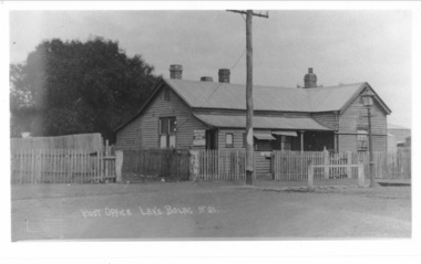
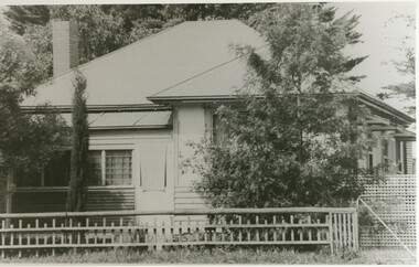
Photograph - Black and white photograph, Lake Bolac Post Office - Glenelg Highway Lake Bolac c.1940s, c1940
... Lake Bolac Post Office - Glenelg Highway Lake Bolac c.1940s......glenelg highway...Lake Bolac Post Office Glenelg Highway. Initially the Post Office was established at the Store in 1868. ...Lake Bolac & District Historical Society 2110 Glenelg Highway Lake Bolac grampians Lake Bolac Post Office Glenelg Highway. ...Lake Bolac Post Office Glenelg Highway. Initially the Post Office was established at the Store in 1868. This official weatherboard building was opened in 1887 incorporating a telegraph office, money order office and post office savings bank. The Post Office business was relocated in 1944 and the building was used as a private residence with the front room leased to Dennys Lascelles. Note the horse hitching rail and kerosene street light.Photograph depicting a weatherboard building across a road. The building is fenced. In front of the building there is a telegraphic or electric post and a lamp post.lake bolac, post office, glenelg highway, dennys lascelles -
 Linton and District Historical Society Inc
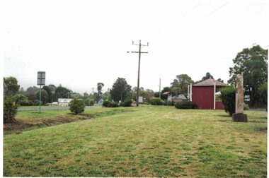
Photograph, View to south-east, Glenelg Highway, Linton, 2014
... View to south-east, Glenelg Highway, Linton, 2014...Colour photograph which shows the memorial to firefighters who died near Linton in 1998, the rotunda near the Linton takeaway shop, and a house further along on the east side of the Glenelg Highway....Linton and District Historical Society Inc 69 Sussex Street Linton 3360 goldfields Linton rotunda Memorials Monuments Firefighters Colour photograph which shows the memorial to firefighters who died near Linton in 1998, the rotunda near the Linton takeaway shop, and a house further along on the east side of the Glenelg Highway. View to south-east, Glenelg Highway, Linton, 2014 Photograph ...Colour photograph which shows the memorial to firefighters who died near Linton in 1998, the rotunda near the Linton takeaway shop, and a house further along on the east side of the Glenelg Highway.linton rotunda, memorials, monuments, firefighters -
 Lake Bolac & District Historical Society
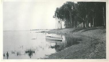
Photograph - black and white photograph, Lake Bolac 1920, c1920
... ...glenelg highway...This photograph of Lake Bolac was taken at the northern, Glenelg Highway end of the lake near the property known as 'Lakeview' - the O'Rorke Family home....Lake Bolac & District Historical Society 2110 Glenelg Highway Lake Bolac grampians This photograph of Lake Bolac was taken at the northern, Glenelg Highway end of the lake near the property known as 'Lakeview' - the O'Rorke Family home. lake bolac glenelg highway lakeview mr o'rorke Black and white photograph Lake Bolac 1920 Photograph black and white photograph ...This photograph of Lake Bolac was taken at the northern, Glenelg Highway end of the lake near the property known as 'Lakeview' - the O'Rorke Family home.Black and white photographlake bolac, glenelg highway, lakeview, mr o'rorke -
 Lake Bolac & District Historical Society
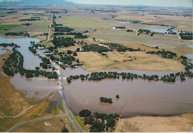
Colour photograph, Wickliffe Flood, Jan .2011
... Wickliffe, Hopkins River, flood, Glenelg Highway...Wickliffe, the flooded Hopkins River flowing from left to right, both under and over the bridge, showing the inundated Glenelg Highway and township. January, 2011. Photograph courtesy James Davidson....Lake Bolac & District Historical Society 2110 Glenelg Highway Lake Bolac grampians Wickliffe, the flooded Hopkins River flowing from left to right, both under and over the bridge, showing the inundated Glenelg Highway and township. ...Wickliffe, the flooded Hopkins River flowing from left to right, both under and over the bridge, showing the inundated Glenelg Highway and township. January, 2011. Photograph courtesy James Davidson.wickliffe, hopkins river, flood, glenelg highway -
 Lake Bolac & District Historical Society
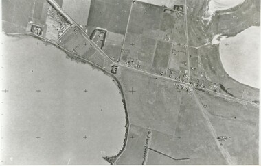
Black and white photograph, Aerial View of Lake Bolac, 1947
... Lake Bolac, 1947, Glenelg Highway...Fresh water lake at bottom left, salt lakes at top right, village at crossroads of north-south Glenelg highway and Ararat-Mortlake road....Fresh water lake at bottom left, salt lakes at top right, village at crossroads of north-south Glenelg highway and Ararat-Mortlake road. Lake Bolac, 1947, Glenelg Highway Aerial View of Lake Bolac, 1947. ...Aerial view of Lake Bolac (Boloke) taken in 1947. Fresh water lake at bottom left, salt lakes at top right, village at crossroads of north-south Glenelg highway and Ararat-Mortlake road.lake bolac, 1947, glenelg highway -
 Lake Bolac & District Historical Society
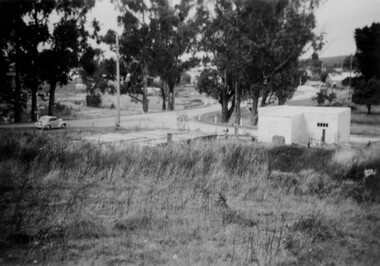
Black and white photograph, Second Lake Bolac Bush Nursing Centre
... Second Lake Bolac Bush Nursing Centre on Glenelg Highway. Centre was in use from 1933 until 1957....Lake Bolac & District Historical Society 2110 Glenelg Highway Lake Bolac grampians Second Lake Bolac Bush Nursing Centre on Glenelg Highway. ...Second Lake Bolac Bush Nursing Centre on Glenelg Highway. Centre was in use from 1933 until 1957. -
 Linton and District Historical Society Inc
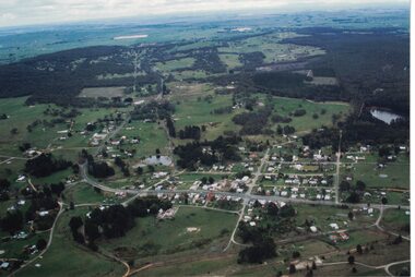
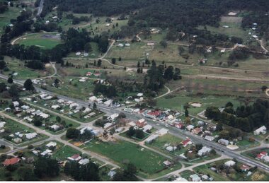
Photograph, Photographer: Alan Giles, Aerial View, Sussex Street, Linton, 1991, 1.9.1991
... Aerial view of Linton, Sussex St (Glenelg Highway) running from RH bottom corner, Mortchup Road reservoir centre RH side....Aerial view of Linton, Sussex St (Glenelg Highway) running from RH bottom corner, Mortchup Road reservoir centre RH side. ...Aerial view of Linton, Sussex St (Glenelg Highway) running from RH bottom corner, Mortchup Road reservoir centre RH side."Linton Township, Vic-1st September 1991".linton township, sussex street linton -
 Linton and District Historical Society Inc
Photograph, Memorial to Firefighters, Linton
... Colour photograph of the memorial on the Glenelg Highway at the Ballarat-end entrance to Linton. ...Memorials Monuments Firefighters CFA volunteers Linton bushfire 1998 Colour photograph of the memorial on the Glenelg Highway at the Ballarat-end entrance to Linton. ...The memorial was erected in August 2000, and the design represents an eternal flame.Colour photograph of the memorial on the Glenelg Highway at the Ballarat-end entrance to Linton. The monument commemorates the five firefighters who died in a bushfire near Linton in December 1998.memorials, monuments, firefighters, cfa volunteers, linton bushfire 1998 -
 Linton and District Historical Society Inc
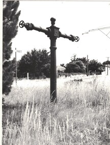
Photograph, Standpipe at Linton
... Black and white copy of original photograph, mounted on white card, which shows the standpipe at Linton, located near the corner of the Glenelg Highway and the Linton-Naringhil Road....Standpipe Water supply Black and white copy of original photograph, mounted on white card, which shows the standpipe at Linton, located near the corner of the Glenelg Highway and the Linton-Naringhil Road. Standpipe at Linton Photograph ...The standpipe is thought to have been installed in the 1880s, and pre-dates piped water to Linton. Water from it was used for domestic purposes, and also to fight fires.Black and white copy of original photograph, mounted on white card, which shows the standpipe at Linton, located near the corner of the Glenelg Highway and the Linton-Naringhil Road.standpipe, water supply -
 City of Ballarat Libraries
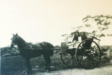
Photograph - Card Box Photographs, Una & Mary Kent at their Dairy circa 1925
... Una & Mary in their horse drawn gig on their property in Smythes Road (Glenelg Highway)....City of Ballarat Libraries Eureka Centre Eureka Street Ballarat East goldfields Una & Mary in their horse drawn gig on their property in Smythes Road (Glenelg Highway). kent's dairy una kent mary kent smythes road vehicle persons Una & Mary Kent at their Dairy circa 1925. ...Una & Mary in their horse drawn gig on their property in Smythes Road (Glenelg Highway).kent's dairy, una kent, mary kent, smythes road, vehicle, persons -
 Linton and District Historical Society Inc
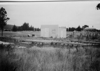
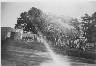
Photograph, McDonald Home Under Construction, Linton, 1954
... Looking south from Glenelg Highway....Looking south from Glenelg Highway. Buildings Houses Basil McDonald Marjorie McDonald Black and white photograph of a shed and brick foundations of a house with small house on hill in background. ...House being built by Basil McDonald in 1954. Looking south from Glenelg Highway.Black and white photograph of a shed and brick foundations of a house with small house on hill in background.buildings, houses, basil mcdonald, marjorie mcdonald -
 Lake Bolac & District Historical Society
black & white photograph, Second Lake Bolac Bush Nursing Centre, 1933-57
... Second Lake Bolac Bush Nursing Centre, Glenelg Highway, Lake Bolac. 1933-1957....Lake Bolac & District Historical Society 2110 Glenelg Highway Lake Bolac grampians Second Lake Bolac Bush Nursing Centre, Glenelg Highway, Lake Bolac. 1933-1957. ...Second Lake Bolac Bush Nursing Centre, Glenelg Highway, Lake Bolac. 1933-1957.lake bolac, bush nursing centre -
 Linton and District Historical Society Inc
Photograph, McDonald Home Under Construction, Linton, 1954
... Photo taken looking east along Glenelg Highway. Vauxhall car in photo belonged to Basil McDonald whose house was under construction....Linton and District Historical Society Inc 69 Sussex Street Linton 3360 goldfields Photo taken looking east along Glenelg Highway. Vauxhall car in photo belonged to Basil McDonald whose house was under construction. ...Photo taken looking east along Glenelg Highway. Vauxhall car in photo belonged to Basil McDonald whose house was under construction.Black and white photograph of a shed and foundations of a house on a corner with car parked on the side of the road.buildings, houses, basil mcdonald, marjorie mcdonald -
 Linton and District Historical Society Inc
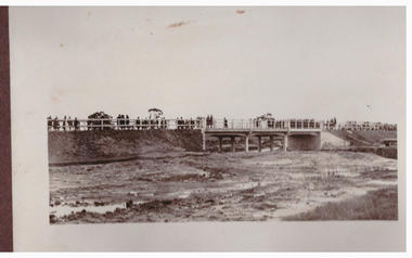
Photograph, Bridge Opening
... The picture shows the opening of the Glenelg Highway Bridge over the Woady Yaloak Creek between Linton and Scarsdale....The picture shows the opening of the Glenelg Highway Bridge over the Woady Yaloak Creek between Linton and Scarsdale. ...Part of photograph album donated by Mrs Faull. The picture shows the opening of the Glenelg Highway Bridge over the Woady Yaloak Creek between Linton and Scarsdale.Black and white photograph of bridge opening. Bridge in background with people and cars.events, bridge openings, faull collection, woady yaloak creek -
 Linton and District Historical Society Inc
Photograph, McDonald Home Under Construction, Linton, 1954
... Home being constructed on the corner of the Glenelg Highway and Geelong Road, Linton, for Basil and Marjorie McDonald - Basil being the builder. ...Linton and District Historical Society Inc 69 Sussex Street Linton 3360 goldfields Home being constructed on the corner of the Glenelg Highway and Geelong Road, Linton, for Basil and Marjorie McDonald - Basil being the builder. ...Home being constructed on the corner of the Glenelg Highway and Geelong Road, Linton, for Basil and Marjorie McDonald - Basil being the builder. The house was built on the site formerly occupied by the Victoria Hotel.Black and white photograph of a shed and house under construction with frame and pitched roof. Light streaming across photo."Taken from across the road on the corner 1954"buildings, houses, basil mcdonald, marjorie mcdonald -
 Ballarat Heritage Services
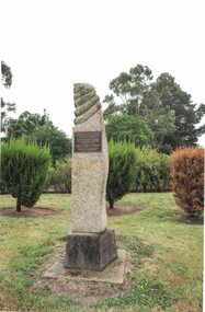
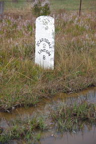
Photograph, LJ Gervasoni, Scarsdale/Linton Milepost (or Milestone), 20-06/2009
... The stone mileposts on the Glenelg Highway are listed on the Victorian Heritage Reigister as being significant to the State of Victoria. ...The stone mileposts on the Glenelg Highway are listed on the Victorian Heritage Reigister as being significant to the State of Victoria. ...Stone mileposts dating from the 1870s are found on the Glenelg Highway. Stone and iron mileposts are now a rarity, and have remanining markers have become a tourist attaction in many smaller towns with remnant markers. The stone mileposts on the Glenelg Highway are listed on the Victorian Heritage Reigister as being significant to the State of Victoria. Their primary purpose is to inform the travelling public of distances and directions to various destinations. The stone milepost in the current City of Ballarat are located on the Glenelg Highway (between Ballarat and Scarsdale), Smythes Creek and Delacombe, and have been registered by Heritage Victoria, (HO155) Other stone mileposts are located In Golden Plains Shire at Smythesdale (Victorian Heritage Register H1701) Metrication in Australia caused former mile markers to be gradually replaced with 10 km markers on highways and country roads, which are referred to as "kilometre plates".Colour photograph of a stone mile post on between Ballarat, Scarsdale and Lintonmilepost, mile post, scarsdale, linton, ballarat, mile marker, stone milepost, milestone -
 Linton and District Historical Society Inc
Photograph, Photographer: Alan Giles, Aerial View of Linton, 1991, 1.9.1991
... Shows oval, left top corner, Sussex St (Glenelg Highway) running from bottom RH corner....Shows oval, left top corner, Sussex St (Glenelg Highway) running from bottom RH corner. ...Photograph taken by Alan Giles whilst on a joy flight over Linton. Shows oval, left top corner, Sussex St (Glenelg Highway) running from bottom RH corner.Colour photograph, aerial view of Linton township looking north."Linton township, Vic-1st September 1991".linton township -
 Ballarat Tramway Museum
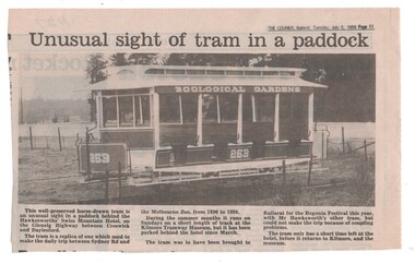
Newspaper, The Courier Ballarat, "Unusual sight of tram in a paddock", 5/07/1988 12:00:00 AM
... Newspaper cutting from The Courier, Ballarat, Tuesday 5/7/1988, page 11 of replica Melbourne Zoo horse tram 269 at Daryl Hawksworth's Swiss Mountain Hotel on the Glenelg Highway between Creswick and Daylesford. ...Ballarat Tramway Museum South Gardens Reserve Wendouree Parade Ballarat Ballarat goldfields Trams tramways Zoo Tram Kilmore Swiss Mountain Hotel Daryl Hawksworth Horse Trams Newspaper cutting from The Courier, Ballarat, Tuesday 5/7/1988, page 11 of replica Melbourne Zoo horse tram 269 at Daryl Hawksworth's Swiss Mountain Hotel on the Glenelg Highway between Creswick and Daylesford. ...Newspaper cutting from The Courier, Ballarat, Tuesday 5/7/1988, page 11 of replica Melbourne Zoo horse tram 269 at Daryl Hawksworth's Swiss Mountain Hotel on the Glenelg Highway between Creswick and Daylesford. Mentions use of tram at Kilmore, proposed use at Ballarat but coupling problems and soon to return to Kilmore.trams, tramways, zoo tram, kilmore, swiss mountain hotel, daryl hawksworth, horse trams -
 Lake Bolac & District Historical Society
Black and white photo, Lake Bolac Post Office 1904
... This was the original Post Office opened in 1887 and was located on the Glenelg Highway. It later became an office for Denny's Lascelles stock agents....Lake Bolac & District Historical Society 2110 Glenelg Highway Lake Bolac grampians Pictured outside the Lake Bolac Post Office in 1904 are Mr Dalgleish and Post Mistress, Miss Frances Pola (later Mrs George Murray). ...Pictured outside the Lake Bolac Post Office in 1904 are Mr Dalgleish and Post Mistress, Miss Frances Pola (later Mrs George Murray). This was the original Post Office opened in 1887 and was located on the Glenelg Highway. It later became an office for Denny's Lascelles stock agents.black and white photographpost office, frances murray, 1904, dalgleish, post mistress -
 Warrnambool and District Historical Society Inc.
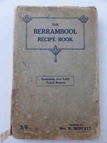
Book, The Berrambool recipe book, 1915
... Wickliffe is a small town in Western Victoria situated on the banks of the Hopkins River on the Glenelg Highway 100 kilometres from Warrnambool. ...Wickliffe is a small town in Western Victoria situated on the banks of the Hopkins River on the Glenelg Highway 100 kilometres from Warrnambool. ...This recipe book has been compiled by Mrs W. Moffatt to raise funds for the Wickliffe Hall Improvement Fund (1915). Wickliffe is a small town in Western Victoria situated on the banks of the Hopkins River on the Glenelg Highway 100 kilometres from Warrnambool. Jessie Moffatt (nee McLellan) married William Moffatt in 1885 and died in 1938. William Moffatt leased the Berrambool Estate near Wickliffe in 1893, bought it in 1903 and the Moffatts lived there until their deaths in the 1930s. This recipe book is of interest because of its social history, telling us what recipes were popular in the early 1900s and the use made of a recipe book to raise funds for local community projects. The book is also of interest because it is an example of the voluntary work done by a woman in the Western District in the early 20th century. The book is also of interest because the names of some of those who contributed the recipes are listed and many of them have local connections. The Warrnambool names listed include Williams and McCormick. This is a soft cover book of 149 pages. The cover is grey with dark blue lettering and some ornamental patterning. The book contains over 1400 recipes and many advertisements for businesses in Victoria at the back and front of the book. There are two loose sheets of paper with recipes. The binding has come apart and has been loosely mended with adhesive tape. The cover and some of the pages are a little tattered. jessie and william moffatt of berrambool, history of warrnambool -
 Warrnambool and District Historical Society Inc.
Book, Streets of Hamilton, 2007 (revised and reprinted 2009)
... Hamilton is a city in Western Victoria at the intersection of the Glenelg Highway and the Henty Highway. European settlement began with the arrival of pastoralists following the 1836 explorations of Major Thomas Mitchell. ...Hamilton is a city in Western Victoria at the intersection of the Glenelg Highway and the Henty Highway. European settlement began with the arrival of pastoralists following the 1836 explorations of Major Thomas Mitchell. ...This is a book providing information on the streets of Hamilton, Victoria and the origin of the names. Hamilton is a city in Western Victoria at the intersection of the Glenelg Highway and the Henty Highway. European settlement began with the arrival of pastoralists following the 1836 explorations of Major Thomas Mitchell. The Wedge family in 1839 had the property ‘The Grange’ which covered the site of Hamilton today. The town was gazetted in 1851 and named after a place in Scotland. Hamilton Victoria is the centre of a sheep-grazing and agricultural district. The book won an award in the 2008 Victorian Community History Awards. This book is of interest as it gives information on the Hamilton streets and the origin of their names. The history of Hamilton is of particular interest to those also living in the Western District. The book will be a useful research tool. This is a soft cover book of 174 pages. The back cover has a white background with black and white photographs of five local Hamilton people. The front cover has a yellow and brown background with black and white photographs of five local Hamilton people, an outline of a map of Victoria and a photograph of a map of the Hamilton area with some artefacts placed on the map. The book contains an Introduction, a Preface, a Foreword, an Early Days Overview, a list of Contents, a list of the streets in alphabetical order with information on the origin of the names, two Appendices and an Index. The book has many black and white photographs and sketches. Front Cover: ‘2nd Edition’ ‘The Streets of Hamilton’ ‘Western Victoria Australia’ ‘By John McKay’ ‘A History of the People behind the Names’hamilton, victoria, john mckay, street names of hamilton, warrnambool -
 Glenelg Shire Council Cultural Collection
Photograph - Photograph - Thomas Borthwick and Sons abattoirs and Australian Estates wool stores, 1968
... Glenelg Shire Council Cultural Collection History House Cliff Street Portland great-ocean-road Port of Portland Authority archives. Port of Portland Archives Front: (no inscriptions) Back: OPEN COUNTRY WEEST OF THE HENTY HIGHWAY AT NORTH PORTLAND JAN 1968/ PORTLAND HARBOUR TRUST COMMISSIONERS Black and white photograph taken from the west. ...Port of Portland Authority archives.Front: (no inscriptions) Back: OPEN COUNTRY WEEST OF THE HENTY HIGHWAY AT NORTH PORTLAND JAN 1968/ PORTLAND HARBOUR TRUST COMMISSIONERSport of portland archives -
Glenelg Shire Council Cultural Collection
Card - Mobile Road Guide, c. 1970
... Glenelg Shire Council Cultural Collection History House Cliff Street Portland great-ocean-road Back: Purple stamp 'REYNOLDS MOTORS PTY LTD 64 PERCY STREET PORTLAND TEL. 167.168 Light card. Mobile Road Guide of Victoria with insets of interstate routes to Sydney and Adelaide. Pale green card, major highways ...Light card. Mobile Road Guide of Victoria with insets of interstate routes to Sydney and Adelaide. Pale green card, major highways in red, secondary roads dark green, major cities in black, mileage between markers, red. Road guide folded, black and white cityscape on front, bordered by dark green with white print, other symbols red, white, black.Back: Purple stamp 'REYNOLDS MOTORS PTY LTD 64 PERCY STREET PORTLAND TEL. 167.168 -
 Lake Bolac & District Historical Society
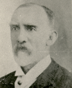
Black and white photograph, W.E. Veale Senior 1839-1911
... Lake Bolac & District Historical Society 2110 Glenelg Highway Lake Bolac grampians This photo shows Mr William E. ...This photo shows Mr William E. Veale Senior, owner of the Lake Bolac Store from 1874 to 1938.black and white photographwilliam e. veale, 1879 -
 Lake Bolac & District Historical Society
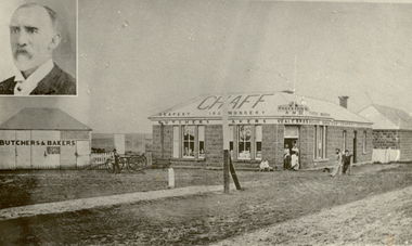
Black and white photo, Original Lake Bolac Store erected in 1868
... Lake Bolac & District Historical Society 2110 Glenelg Highway Lake Bolac grampians This bluestone store replaced a small wooden store on the cross roads site in 1858. ...This bluestone store replaced a small wooden store on the cross roads site in 1858. Store owned by William Veale and his brothers Arthur and George . Originally built by Cecil Louisson. Sold to William Veale Senior in 1874 who owned it until 1938 when it was sold to Mr Dixon. black and white photographbluestone store, lake bolac 1868, 1879, w.e. veale, veale brothers, chaff, butcher, baker, drapery, ironmongery, post office -
 Lake Bolac & District Historical Society
Photograph - Black and white photograph, Lake Bolac Post Office Opening, 1887
... Lake Bolac & District Historical Society 2110 Glenelg Highway Lake Bolac grampians Photograph showing the opening of the first Post Office in Lake Bolac in 1887. ...Photograph showing the opening of the first Post Office in Lake Bolac in 1887. Pictured at the opening are G Veale, Marion Ward, Mrs Tom Ward, Robert McMillan and Blanche Ward.Photograph depicting a group of 5 men and women in front of a building. post office, lake bolac, g. veale, mrs tom ward, robert mcmillan, blanche ward, marion ward -
 Lake Bolac & District Historical Society
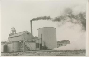
Black and white photograph, Lake Bolac Flax Mill
... Lake Bolac & District Historical Society 2110 Glenelg Highway Lake Bolac grampians Photograph of Lake Bolac Flax Mill boiler house and pits in full production. ...Photograph of Lake Bolac Flax Mill boiler house and pits in full production. The mill operated between 1942 and 1959 and was located on the shores of Lake Bolac. Local farmers grew flax which was transported into the factory to be processed. The mill employed Land Army girls, locals and migrant workers.Photograph of Lake Bolac Flax Mill boiler house and pits in full production. -
 Lake Bolac & District Historical Society
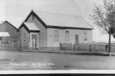
Photograph - Black and white photograph, Lake Bolac Public Hall 1896, 1896
... Lake Bolac & District Historical Society 2110 Glenelg Highway Lake Bolac grampians Lake Bolac Public Hall, Mongomery Street in 1896. ...Lake Bolac Public Hall, Mongomery Street in 1896. Weatherboard construction by Mr Ollie Anderson of Ararat. Opened by district MP Mr McLellan. In 1922 this building was relocated across Montgomery Street to become the supper room for the newly erected Memorial Hall honouring World War 1 soldiers.black and white photographlake bolac, public hall, montgomery street, ollie anderson, mr mclellan -
 Lake Bolac & District Historical Society
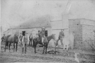
Photograph - Blacksmith Shop Lake Bolac, Blacksmith Shop Lake Bolac
... Lake Bolac & District Historical Society 2110 Glenelg Highway Lake Bolac grampians The Blacksmith Shop was built c.1865 by Mr Child. ...The Blacksmith Shop was built c.1865 by Mr Child. It was purchased by his employee Josiah McNickle Park in 1869, who began the business of J.Park & Son Blacksmith & Wheelwright. It is constructed from bluestone and weatherboard. Photograph shows 7 men, 3 horses and assorted tools. -
 Lake Bolac & District Historical Society
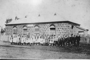
Photograph - Lake Bolac State School 1893, Lake Bolac State School No. 854
... Lake Bolac & District Historical Society 2110 Glenelg Highway Lake Bolac grampians Application was made for a mixed school known as Parupa Common School in 1865. ...Application was made for a mixed school known as Parupa Common School in 1865. Building by Robert Pitkethley commenced in 1867. The name was changed to Lake Bolac State School No. 854 in 1870. The school was bluestone with galvanised iron roof. 30ft x 18ft x 10ft high with teacher residence attached. The building was used from 1867 to 1925 when it was sold for removal. Photograph shows Teacher William Bartlett and students in 1893.