
Showing 12 items matching "gravel reserve"
-
 Federation University Historical Collection
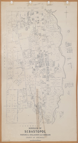
Plan, Borough of Sebastopol, 1940, 01/07/1940
... ...Gravel reserve...Sebastopol became a suburb of the City of Ballarat. sebastopol t. rider yarrowee creek leigh river St George's Reserve Leigh Creek Sebastopol Public Gardens Sebastopol Recreation Reserve Gravel reserve Night Soil Depot Sanitary depot Rubbish depot Plan showing the streets, allotments creeks in the Borough of Sebastopol, Parishes of Ballaarat and Cardigan, County of Grenville, in 1940. ...Sebastopol became a suburb of the City of Ballarat.Plan showing the streets, allotments creeks in the Borough of Sebastopol, Parishes of Ballaarat and Cardigan, County of Grenville, in 1940. sebastopol, t. rider, yarrowee creek, leigh river, st george's reserve, leigh creek, sebastopol public gardens, sebastopol recreation reserve, gravel reserve, night soil depot, sanitary depot, rubbish depot -
 Federation University Historical Collection
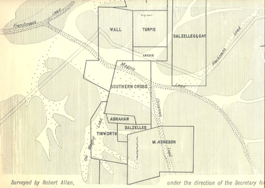
Plan, Underground Survey of Mines, Ballarat East, 1885, 09/1889
... gravel pitts lead golden point lead navy jack's lead mopoke lead eureka lead association lead warrenheip lead cgt plans Rectangular plan showing placement of mines in 1889. Mines include Hick's and Gilpin's lease, Comstock, Melbourne Company, Victoria United, Speedwell Company, New Normanby, Pasha Surprise, Central Sulieman, West Llanberris, Britannia United, Victoria Unites, Clinton's, Orient Company, North Sulieman, Sulieman Extended, Pasha Surprise, Golden Fountain, Prince regent, Clark and Company, Tinworth, North Woah Hawp, Detering, R.A. Thompson, Dazelles and buchanan, Barnett, Braybrook, Ladt Cornwall, Hanthorne, Dalzelles and gay, Southern Cross, M. Acheson, Cricket Reserve ...Surveyed by Robert Allan under the direction of the Secretary of Mines.Rectangular plan showing placement of mines in 1889. Mines include Hick's and Gilpin's lease, Comstock, Melbourne Company, Victoria United, Speedwell Company, New Normanby, Pasha Surprise, Central Sulieman, West Llanberris, Britannia United, Victoria Unites, Clinton's, Orient Company, North Sulieman, Sulieman Extended, Pasha Surprise, Golden Fountain, Prince regent, Clark and Company, Tinworth, North Woah Hawp, Detering, R.A. Thompson, Dazelles and buchanan, Barnett, Braybrook, Ladt Cornwall, Hanthorne, Dalzelles and gay, Southern Cross, M. Acheson, Cricket Reserveballarat east, mines, mining, underground survey, robert allan, chinese, ah chong, ah young, bakery hill, black hill, black hill lead, bakery hill lead, cricket, pennyweight hill, gravel pitts lead, golden point lead, navy jack's lead, mopoke lead, eureka lead, association lead, warrenheip lead, cgt, plans -
 Federation University Historical Collection
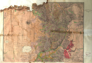
Map, Ballarat Goldfield, c1898
... reserve...Winter's swamp...Kneeshar Co...Monte Cristo line of reef...Chinaman's Gully or Black Snake...Milkmaid's Gully...Ballarat gold field...Bakery Hil Lead...Old gravel...The Ballarat Industrial School ran from 1869-1879, but the term Ballarat Industrial School Reserve was still in use in 1898 and possibly beyond. ballarat warrenheip lake wendouree ballarat east winters swamp winter swamp wyndholm premptive right cemetery vale park reserve little bendigo kneeshaw co. industrial school reserve kirks dam pincotts dam black hill wombat hill dead horse gully miners rest mt rowan salton and waldie rose hill co great north west no 1 rose's freehold co hand and band co police reserve police paddock mount rowan ballarat industrial school reserve market reserve Winter's swamp Kneeshar Co Monte Cristo line of reef Chinaman's Gully or Black Snake Milkmaid's Gully Ballarat gold field Bakery Hil Lead Old gravel pits lead Golden point lead Eureka Lead Miner's Rest Yarrowee Creek Leigh Creek Black Swamp Lead Yorkshire Reef Nil Desperandum reef Cockatoo Lead HIt or Miss Gully herbert werner frederick de nully Pennyweight Hill Esmond's Lead Ash's Lead Nightingale Lead John Bull Gully Gladstone Reef Whitehorse reef Petticoat Creek Pincott's Dam Frenchman's Gully Tim's Crushing Plant Jenkin's Gully California Gully Drake's Creek Sulton and Waldie Ballarat Undustrial School Ballarat & Mariborough Railway Geological Map of Ballarat with 3 holes in the left hand side. ...This map shows geological features, suggests the last basalt flow, and includes alotments and names of Mining Companies. Although this map has no date on it the Ballarat Industrial School is used for dating purposed. The Ballarat Industrial School ran from 1869-1879, but the term Ballarat Industrial School Reserve was still in use in 1898 and possibly beyond.Geological Map of Ballarat with 3 holes in the left hand side. The map indicates the position of Lake Wendouree, Township of Warrenheip, Ballarat East, Industrial School Reserve, Winters Swamp, Police Paddock, Wyndholm Premptive Right (Salton and Waldie), Black Hill, Vale Park Reserve, Pennyweight Hill, Little Bendigo, Black Swamp Lead, monte Christo Reef, Chinaman's Gully, Miners Rest, Pincotts Dam, Northumberland Gully. It also show the following goldmining companies: City of Ballarat, Kohinor, Hand and Band, Great North West, Northern Junction, Kneeshaw, Rossers Freehold, Silurial.ballarat, warrenheip, lake wendouree, ballarat east, winters swamp, winter swamp, wyndholm premptive right, cemetery, vale park reserve, little bendigo, kneeshaw co., industrial school reserve, kirks dam, pincotts dam, black hill, wombat hill, dead horse gully, miners rest, mt rowan, salton and waldie, rose hill co, great north west no 1, rose's freehold co, hand and band co, police reserve, police paddock, mount rowan, ballarat industrial school reserve, market reserve, winter's swamp, kneeshar co, monte cristo line of reef, chinaman's gully or black snake, milkmaid's gully, ballarat gold field, bakery hil lead, old gravel pits lead, golden point lead, eureka lead, miner's rest, yarrowee creek, leigh creek, black swamp lead, yorkshire reef, nil desperandum reef, cockatoo lead, hit or miss gully, herbert werner frederick de nully, pennyweight hill, esmond's lead, ash's lead, nightingale lead, john bull gully, gladstone reef, whitehorse reef, petticoat creek, pincott's dam, frenchman's gully, tim's crushing plant, jenkin's gully, california gully, drake's creek, sulton and waldie, ballarat undustrial school, ballarat & mariborough railway -
 Federation University Historical Collection
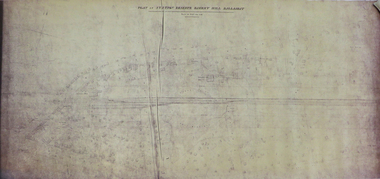
Plan, Station Reserve Bakery Hill, Ballaarat
... reserve...bakery hill...railway...Ballarat...Mair Street...Humffray Street NOrth...Duke of York Hotel...Duke of richmond hotel...union hotel...kingston st...otway st...Wellington Claim...gravel...Station reserve bakery hill railway Ballarat Mair Street Humffray Street NOrth Duke of York Hotel Duke of richmond hotel union hotel kingston st otway st Wellington Claim gravel pits gold workings Robert Burns Hotel .1) Oversized photocopy of large plan depicting railway right of way where Mair and Humffray Streets meet. ....1) Oversized photocopy of large plan depicting railway right of way where Mair and Humffray Streets meet. Main landmarks include Duke of Richmond Hotel, Prince of Wales Hotel, Duke of York Hotel, Welcome Nugget Claim and Shaft, Imperial Hotel, Union Hotel, Kingston St, Otway St, Wellington Claim, Gravel Pits Gold Working and Robert Burns Hotel. .2) Same of above. station reserve, bakery hill, railway, ballarat, mair street, humffray street north, duke of york hotel, duke of richmond hotel, union hotel, kingston st, otway st, wellington claim, gravel pits, gold workings, robert burns hotel -
 Bendigo Historical Society Inc.
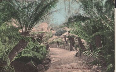
Postcard - ELAINE ROBB COLLECTION: BENDIGO FERNERY
... In centre of image, gravel pathway bordered by stonework, ferns on either side. On bottom of card: Fernery,Camp Reserve, Bendigo. ...In centre of image, gravel pathway bordered by stonework, ferns on either side. On bottom of card: Fernery,Camp Reserve, Bendigo. ...Hand coloured postcard: image shows Fernery, Rosalind Park, Bendigo. In centre of image, gravel pathway bordered by stonework, ferns on either side. On bottom of card: Fernery,Camp Reserve, Bendigo. Possibly late 1890's ? On rear of card: Post card W.T.P. in ornate diamond shape (produced by WT Pater, printers & stationers )W.T.Pater -
 Bendigo Historical Society Inc.
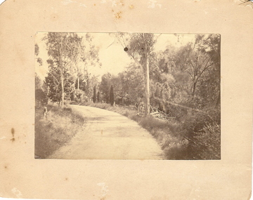
Photograph - BOTANICAL GARDENS
... gravelled, eucalypt and conifer trees, uncut grass, wire fence middle distance. Pathway curving to left from front of photo. Written in blue pen on rear of photo : Botanical Gardens or early path in Fortuna. English trees planted, e.g. cypress. Holdsworth Road, adj. White Hills Cemetery Reserve...gravelled, eucalypt and conifer trees, uncut grass, wire fence middle distance. Pathway curving to left from front of photo. Written in blue pen on rear of photo : Botanical Gardens or early path in Fortuna. English trees planted, e.g. cypress. Holdsworth Road, adj. White Hills Cemetery Reserve ...sepia photograph on cream board. Driveway/pathway, gravelled, eucalypt and conifer trees, uncut grass, wire fence middle distance. Pathway curving to left from front of photo. Written in blue pen on rear of photo : Botanical Gardens or early path in Fortuna. English trees planted, e.g. cypress. Holdsworth Road, adj. White Hills Cemetery Reserve. Crowned road grade. Heavy intermediate fence posts.unknownplace, land, botanical gardens, fortuna ? -
 Bendigo Historical Society Inc.
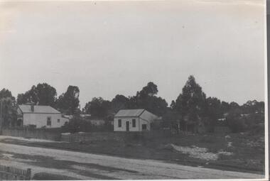
Photograph - Nell Gwynne Gold Mine site, 1934
... Reserve, north west of the reservoir near Diamond Hill Road. An abridged prospectus for the Nell Gwynne (B.M.L.) No Liability, was published in the Sun News Pictorial on 7th June 1934, page 26 (Advertising).https://trove.nla.gov.au/newspaper/article/277316940?searchTerm=napoleon%20bml Significant to mining history of Bendigo. Nell Gwynne Gold Mine Written in pencil on back of photograph in pencil: 'Nell Gwynne 25.9.34' Black and white photograph of two weatherboard houses in bush setting. Gravel ...The Nell Gwynne mine site was within the Spring Gully Water Reserve, north west of the reservoir near Diamond Hill Road. An abridged prospectus for the Nell Gwynne (B.M.L.) No Liability, was published in the Sun News Pictorial on 7th June 1934, page 26 (Advertising).https://trove.nla.gov.au/newspaper/article/277316940?searchTerm=napoleon%20bmlSignificant to mining history of Bendigo.Black and white photograph of two weatherboard houses in bush setting. Gravel road in foreground. Written in pencil on back of photograph in pencil: 'Nell Gwynne 25.9.34'nell gwynne gold mine -
 Lakes Entrance Historical Society
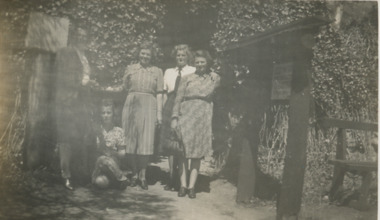
Photograph - St Annes Girls School Teachers at Buchan Caves Buchan Victoria c1949
... Also a black and white photograph of gravel road in Buchan Caves reserve 05439.1 14 X 7 CM...Also a black and white photograph of gravel road in Buchan Caves reserve 05439.1 14 X 7 CM Tourism Schools Teachers Black and white photograph of Miss Dora Bradley, Miss Bailey,Miss Rivers, Miss Carlyle and Miss Turner teachers from St Annes Girls School on visit to Buchan Caves Buchan Victoria Photograph St Annes Girls School Teachers at Buchan Caves Buchan Victoria c1949 ...Also a black and white photograph of gravel road in Buchan Caves reserve 05439.1 14 X 7 CMBlack and white photograph of Miss Dora Bradley, Miss Bailey,Miss Rivers, Miss Carlyle and Miss Turner teachers from St Annes Girls School on visit to Buchan Caves Buchan Victoriatourism, schools, teachers -
 Ballarat Heritage Services
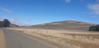
Photograph - Colour Photograph, Clare Gervasoni, Mount Greenock, 2025, 28/06/2025
... gravels). A line of mine tailing and abandoned mining relics associated with the former Union Mine occur on the margins of the lava flow. Mount Greenock is a 120 hectare ‘Geological Reserve...gravels). A line of mine tailing and abandoned mining relics associated with the former Union Mine occur on the margins of the lava flow. Mount Greenock is a 120 hectare ‘Geological Reserve ...Mt Greenock is an extinct volcano with lava flows associated with a deep lead. It is a tall scoria cone with a broad shallow crater open to the northwest. In the crater are blocks and bombs of scoriaceous basalt. Long lava flows extend both north and south from the cone. It is considered a significant geological site, and part of the Major Mitchell Trail, with a 1936 ‘Centenary of Major Mitchell ‘monument on the summit. The flow to the north has been eroded by McCallum Creek which is a lateral stream. On the eastern base of the cone, the stream valley exposes a lava flow and underlying sedimentary rocks. The lava flow and the scoria cone overlie the Greenock lead (a buried valley with auriferous gravels). A line of mine tailing and abandoned mining relics associated with the former Union Mine occur on the margins of the lava flow. Mount Greenock is a 120 hectare ‘Geological Reserve’, is one of the few large scoria cones on public land and contains abundant outcrop and morphological evidence of its volcanic origin. Colour Photographs of Mt Greenock, near Talbot, Victoria. The photographs were taken in winter not long after the first post drought rains. Mt Greenock was climbed by Major Thomas Mitchell on 26 September 1936, and he gave it the current name. At that time the mount was part of Alexander McCallum's Dunach Forest Pastoral Run.mt greenock, mount greenock, mining, mullock heap, mt greenock geological reserve, union mine, volcanic grasslands, dunach -
 Ballarat Heritage Services
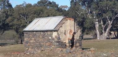
Photograph - Colour Photograph, Clare Gervasoni, Built Remains near Mount Greenock, 2025, 28/06/2025
... gravels). A line of mine tailing and abandoned mining relics associated with the former Union Mine occur on the margins of the lava flow. Mount Greenock is a 120 hectare ‘Geological Reserve...gravels). A line of mine tailing and abandoned mining relics associated with the former Union Mine occur on the margins of the lava flow. Mount Greenock is a 120 hectare ‘Geological Reserve ...Mt Greenock is an extinct volcano with lava flows associated with a deep lead. It is a tall scoria cone with a broad shallow crater open to the northwest. In the crater are blocks and bombs of scoriaceous basalt. Long lava flows extend both north and south from the cone. It is considered a significant geological site, and part of the Major Mitchell Trail, with a 1936 ‘Centenary of Major Mitchell ‘monument on the summit. The flow to the north has been eroded by McCallum Creek which is a lateral stream. On the eastern base of the cone, the stream valley exposes a lava flow and underlying sedimentary rocks. The lava flow and the scoria cone overlie the Greenock lead (a buried valley with auriferous gravels). A line of mine tailing and abandoned mining relics associated with the former Union Mine occur on the margins of the lava flow. Mount Greenock is a 120 hectare ‘Geological Reserve’, is one of the few large scoria cones on public land and contains abundant outcrop and morphological evidence of its volcanic origin. Colour Photographs of bluestone and brick buildings at Mt Greenock, near Talbot, Victoria. The photographs were taken in winter not long after the first post drought rains. mt greenock, mount greenock, mining, mullock heap, mt greenock geological reserve, union mine, volcanic grasslands, dunach -
 Whitehorse Historical Society Inc.
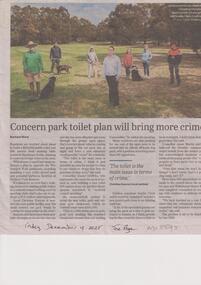
Article, Ward, Rachael, Park Toilet Plan, 19/12/2025
... Whitehorse Council endorsed a plan to upgrade the Wurundjeri Walk parklands including installing a new toilet, gravel path and potential barbecue facilities at Orchard Park Reserve....Whitehorse Council endorsed a plan to upgrade the Wurundjeri Walk parklands including installing a new toilet, gravel path and potential barbecue facilities at Orchard Park Reserve. City og Whitehorse Toilet Block Blackburn South Crime Wurundjeri Walk Ward Rachael Residents are worried about plans to build a $150,000 public toilet just 200 metres from existing bathrooms in Blackburn South, claiming it could encourage crime. ...Residents are worried about plans to build a $150,000 public toilet just 200 metres from existing bathrooms in Blackburn South, claiming it could encourage crime.non-fictionResidents are worried about plans to build a $150,000 public toilet just 200 metres from existing bathrooms in Blackburn South, claiming it could encourage crime.city og whitehorse, toilet block, blackburn south, crime, wurundjeri walk, ward rachael -
 Ringwood and District Historical Society
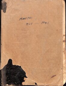
Administrative record, East Ringwood Progress Association Minute Book 1925-1930 and 1946-1948
... Members also undertook practical work themselves, forming working bees to gravel paths, clear drains, and maintain the reserve. The minutes record frequent deputations to Council, correspondence with government departments, and ongoing advocacy for safer crossings, better road surfaces, and public conveniences such as telephone booths and lighting. ...Members also undertook practical work themselves, forming working bees to gravel paths, clear drains, and maintain the reserve. The minutes record frequent deputations to Council, correspondence with government departments, and ongoing advocacy for safer crossings, better road surfaces, and public conveniences such as telephone booths and lighting. ...Hand-written minutes of the East Ringwood Progress Association from 16 November 1925 until 16 June 1930, then continued from 20 May 1946 until 29 November 1948. An additional scan repeats pages 1-3, due to misalignment, and adds names and addresses, for insertion after page 86. Some of 1925-1930 members had surnames Howship, Kelley, Klix, Wedge, Skerritt, Walmsley, Saywell, Watson, Herbert, Neal, Vogel, Hodgkins, etc. Includes records of the formation of the East Ringwood Football Club, and many other local matters. Names for the 1946-48 period were Maggs, Meyland, Rawson, Wedge, Codd, Burke, Hall, Purser, Gowland, Guest, etc. Meetings took place at the Klix's residence then the East Ringwood Pavilion at the Reserve CO-PILOT SUMMARY Between 1925 and 1929 the Ringwood East Progress Association worked steadily to improve local amenities, public safety, and community facilities during a period of rapid growth in the district. The Association secured the opening of the Ringwood East Railway Station, arranged for a daily letter‑receiving box, organised Arbor Day plantings, and repeatedly pressed the Borough Council and Railway Department for footpaths, culverts, drainage works, lighting at dangerous intersections, and improvements to Dublin Road, Eastfield Road, and the approaches to the station. Members also undertook practical work themselves, forming working bees to gravel paths, clear drains, and maintain the reserve. The minutes record frequent deputations to Council, correspondence with government departments, and ongoing advocacy for safer crossings, better road surfaces, and public conveniences such as telephone booths and lighting. The Association also focused on community development, responding to the death of key members, encouraging new membership, and exploring facilities such as a swimming pool, tennis courts, and a public hall for Ringwood East. Although some proposals—such as the Chandler Estate swimming hole—were ultimately rejected, the group continued to investigate suitable hall sites and funding options. Support was given to emerging local clubs, including the Ringwood East Cricket and Junior Football Clubs. Despite occasional low attendance, the Association maintained a consistent program of civic improvement, laying foundations for the future growth of Ringwood East and demonstrating a strong commitment to the welfare and progress of the district.
