Showing 24 items matching "hamilton hume"
-
 Ballarat Heritage Services
Image, Hamilton Hume
... Hamilton Hume......hamilton hume...Reproducation of a image of Hamilton Hume....Ballarat Heritage Services PO Box 2209 Bakery Hill Post Office goldfields portrait hamilton hume explorer Reproducation of a image of Hamilton Hume. ...Reproducation of a image of Hamilton Hume.portrait, hamilton hume, explorer -
 Wodonga & District Historical Society Inc
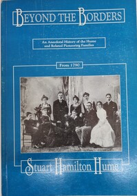
Book - Beyond the Border, Stuart Hamilton Hume, 1991
... Hamilton Hume...Stuart Hamilton Hume...Wodonga & District Historical Society Inc Hut 97, Bonegilla Migrant Experience, 132 Bonegilla Road Bonegilla the-murray Hamilton Hume Australian Pioneers Pioneer life This publication traces the achievements of descendants of Hamilton Hume and connected families. ...This publication traces the achievements of descendants of Hamilton Hume and connected families. This includes the Mitchell, Hume, Kennedy and Huon pastoral families who had strong links to North East VIctoria.A publication of 216 pages includes a detailed account of descendants of the Hume family and their achievements. It includes genealogical tables, portraits, and index and maps on the inside covers.This publication traces the achievements of descendants of Hamilton Hume and connected families. This includes the Mitchell, Hume, Kennedy and Huon pastoral families who had strong links to North East VIctoria. hamilton hume, australian pioneers, pioneer life -
 Sunshine and District Historical Society Incorporated
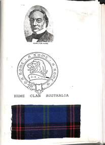
Document - Hume Clan Australia
... Collection of document relating to Andrew Hamilton Hume...Hume & Hovell Hume Clan Australia|Hume & Hovell Overland Journey 1824 - 1825|Hume & Hovell Monuments NSW to Victoria Collection of document relating to Andrew Hamilton Hume Document Hume Clan Australia ...Hume Clan Australia|Hume & Hovell Overland Journey 1824 - 1825|Hume & Hovell Monuments NSW to Victoriahume & hovell -
 The Beechworth Burke Museum
Photograph
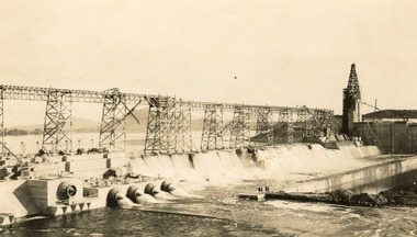
... ...Hamilton Hume...Hume and Hovell: Hamilton Hume (1979-1873) and William Hilton Hovell (1786-1875). ...Hume and Hovell: Hamilton Hume (1979-1873) and William Hilton Hovell (1786-1875). ...Taken on 25 October 1930, various houses with the Hume Dam under construction are depicted in the background. The construction of the Hume Dam took place from 1919 to 1936. At the time of construction, it was the second largest dam in the world. It was also one of the earliest civil projects developed after the Federation. Some of the Dam workers consisted of World War I veterans. Dam workers often settled their families in Mitta Junction Village and Wodonga. Archaeological surveys were completed by Austral Archaeology, which was done when the Department of Land & Water Conservation was doing work to improve Hume Dam. The archaeological report that came out of the survey recommended three sites of interest where archaeological excavation should be done: Camp Ganger’s Quarters, Stableman’s Quarters, and the Industrial Dump. The excavation uncovered artefacts. Mitta Mitta: Mitta Mitta is situated between Mount Welcome and Mount Misery. It is named after the river that explorers Hume and Hovell discovered in 1824. The town would eventually become a huge gold mining town. Mitta Mitta is called Midamodunga by the local Indigenous peoples Wodonga: Wodonga is situated on the Murray River and is part of North East Victoria. Hume and Hovell: Hamilton Hume (1979-1873) and William Hilton Hovell (1786-1875). W. H. Hovell was born in Norfolk England and Hume was born in Parramatta, New South Wales Hovell and Hume undertook an exploration journey in 1824 and thought they discovered a river, which turned out to be the Murray River. They returned home in 1825, but returned to the area in 1826 and discovered coal in the area. This photo is historically significant as it shows the Hume Dam under construction in 1930. The Dam was named after Hamilton Hume, who is an important historical figure for this area as he helped discover the area where resources were found.Sepia rectangular photograph printed unmountedReverse: 84-19-5 / 1997.3185/ Values & spillway. / When completed the wall / will be as high as the / scaffolding. [featuring trademark: kodak print]construction, houses, veterans, mitta junction village, hume dam, world war i, federation, wodonga, archaeological survey, excavation, austral archaeology, department of land & water conservation, camp ganger's quarter's, stableman's quarters, industrial dump, artefacts, mitta mitta, mount welcome, mount misery, murray river, hamilton hume, william hilton hovell, hume and hovell expedition -
 The Beechworth Burke Museum
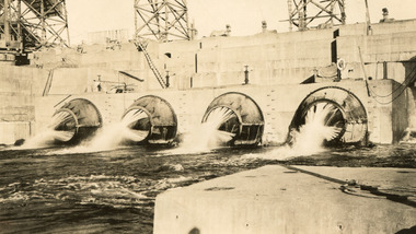
Photograph, c1930
... ...Hamilton Hume...Hume and Hovell: Hamilton Hume (1979-1873) and William Hilton Hovell (1786-1875). ...Hume and Hovell: Hamilton Hume (1979-1873) and William Hilton Hovell (1786-1875). ...Taken on 25 October 1930, various houses with the Hume Dam under construction are depicted in the background. The construction of the Hume Dam took place from 1919 to 1936. At the time of construction, it was the second largest dam in the world. It was also one of the earliest civil projects developed after the Federation. Some of the Dam workers consisted of World War I veterans. Dam workers often settled their families in Mitta Junction Village and Wodonga. Archaeological surveys were completed by Austral Archaeology, which was done when the Department of Land & Water Conservation was doing work to improve Hume Dam. The archaeological report that came out of the survey recommended three sites of interest where archaeological excavation should be done: Camp Ganger’s Quarters, Stableman’s Quarters, and the Industrial Dump. The excavation uncovered artefacts. Mitta Mitta: Mitta Mitta is situated between Mount Welcome and Mount Misery. It is named after the river that explorers Hume and Hovell discovered in 1824. The town would eventually become a huge gold mining town. Mitta Mitta is called Midamodunga by the local Indigenous peoples Wodonga: Wodonga is situated on the Murray River and is part of North East Victoria. Hume and Hovell: Hamilton Hume (1979-1873) and William Hilton Hovell (1786-1875). W. H. Hovell was born in Norfolk England and Hume was born in Parramatta, New South Wales Hovell and Hume undertook an exploration journey in 1824 and thought they discovered a river, which turned out to be the Murray River. They returned home in 1825, but returned to the area in 1826 and discovered coal in the area.This photo is historically significant as it shows the Hume Dam under construction in 1930. The Dam was named after Hamilton Hume, who is an important historical figure for this area as he helped discover the area where resources were found.Sepia rectangular photograph printed unmountedReverse: 84-19-2/ 1997.3188/ These are the four / release valves they are / not always open (illegible) this / when closed the water flows / over the spillway. [featuring trademark: kodak print] photograph number: 354construction, houses, veterans, mitta junction village, hume dam, world war i, federation, wodonga, archaeological survey, excavation, austral archaeology, department of land & water conservation, camp ganger's quarter's, stableman's quarters, industrial dump, artefacts, mitta mitta, mount welcome, mount misery, murray river, hamilton hume, william hilton hovell, hume and hovell expedition -
 The Beechworth Burke Museum
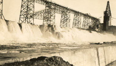
Photograph, 25 October 1930
... ...Hamilton Hume...Hume and Hovell: Hamilton Hume (1979-1873) and William Hilton Hovell (1786-1875). ...Hume and Hovell: Hamilton Hume (1979-1873) and William Hilton Hovell (1786-1875). ...Taken on 25 October 1930, various houses with the Hume Dam under construction are depicted in the background. The construction of the Hume Dam took place from 1919 to 1936. At the time of construction, it was the second largest dam in the world. It was also one of the earliest civil projects developed after the Federation. Some of the Dam workers consisted of World War I veterans. Dam workers often settled their families in Mitta Junction Village and Wodonga. Archaeological surveys were completed by Austral Archaeology, which was done when the Department of Land & Water Conservation was doing work to improve Hume Dam. The archaeological report that came out of the survey recommended three sites of interest where archaeological excavation should be done: Camp Ganger’s Quarters, Stableman’s Quarters, and the Industrial Dump. The excavation uncovered artefacts. Mitta Mitta: Mitta Mitta is situated between Mount Welcome and Mount Misery. It is named after the river that explorers Hume and Hovell discovered in 1824. The town would eventually become a huge gold mining town. Mitta Mitta is called Midamodunga by the local Indigenous peoples Wodonga: Wodonga is situated on the Murray River and is part of North East Victoria. Hume and Hovell: Hamilton Hume (1979-1873) and William Hilton Hovell (1786-1875). W. H. Hovell was born in Norfolk England and Hume was born in Parramatta, New South Wales Hovell and Hume undertook an exploration journey in 1824 and thought they discovered a river, which turned out to be the Murray River. They returned home in 1825, but returned to the area in 1826 and discovered coal in the area.This photo is historically significant as it shows the Hume Dam under construction in 1930. The Dam was named after Hamilton Hume, who is an important historical figure for this area as he helped discover the area where resources were found.Sepia rectangular photograph printed unmountedReverse: 84-19-6/ 1997.3187/ The spillway [featuring trademark: kodak print] construction, houses, veterans, mitta junction village, hume dam, world war i, federation, wodonga, archaeological survey, excavation, austral archaeology, department of land & water conservation, camp ganger's quarter's, stableman's quarters, industrial dump, artefacts, mitta mitta, mount welcome, mount misery, murray river, hamilton hume, william hilton hovell, hume and hovell expedition -
 The Beechworth Burke Museum
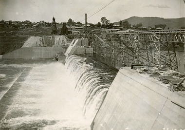
Photograph, 25 October 1930
... ...Hamilton Hume...Hume and Hovell: Hamilton Hume (1979-1873) and William Hilton Hovell (1786-1875). ...Hume and Hovell: Hamilton Hume (1979-1873) and William Hilton Hovell (1786-1875). ...Taken on 25 October 1930, various houses with the Hume Dam under construction are depicted in the background. The construction of the Hume Dam took place from 1919 to 1936. At the time of construction, it was the second largest dam in the world. It was also one of the earliest civil projects developed after the Federation. Some of the Dam workers consisted of World War I veterans. Dam workers often settled their families in Mitta Junction Village and Wodonga. Archaeological surveys were completed by Austral Archaeology, which was done when the Department of Land & Water Conservation was doing work to improve Hume Dam. The archaeological report that came out of the survey recommended three sites of interest where archaeological excavation should be done: Camp Ganger’s Quarters, Stableman’s Quarters, and the Industrial Dump. The excavation uncovered artefacts. Mitta Mitta: Mitta Mitta is situated between Mount Welcome and Mount Misery. It is named after the river that explorers Hume and Hovell discovered in 1824. The town would eventually become a huge gold mining town. Mitta Mitta is called Midamodunga by the local Indigenous peoples Wodonga: Wodonga is situated on the Murray River and is part of North East Victoria. Hume and Hovell: Hamilton Hume (1979-1873) and William Hilton Hovell (1786-1875). W. H. Hovell was born in Norfolk England and Hume was born in Parramatta, New South Wales Hovell and Hume undertook an exploration journey in 1824 and thought they discovered a river, which turned out to be the Murray River. They returned home in 1825, but returned to the area in 1826 and discovered coal in the area.This photo is historically significant as it shows the Hume Dam under construction in 1930. The Dam was named after Hamilton Hume, who is an important historical figure for this area as he helped discover the area where resources were found.Black and white rectangular photograph printer unmountedReverse: 84-20-1/ 1997.3147construction, houses, veterans, mitta junction village, hume dam, world war i, federation, wodonga, archaeological survey, excavation, austral archaeology, department of land & water conservation, camp ganger's quarter's, stableman's quarters, industrial dump, artefacts, mitta mitta, mount welcome, mount misery, murray river, hamilton hume, william hilton hovell, hume and hovell expedition -
 The Beechworth Burke Museum
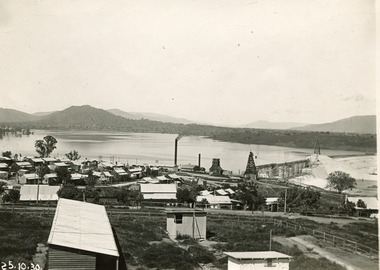
Photograph, 25 October 1930
... ...Hamilton Hume...Hume and Hovell: Hamilton Hume (1979-1873) and William Hilton Hovell (1786-1875). ...Hume and Hovell: Hamilton Hume (1979-1873) and William Hilton Hovell (1786-1875). ...Taken on 25 October 1930, various houses with the Hume Dam under construction are depicted in the background. The construction of the Hume Dam took place from 1919 to 1936. At the time of construction, it was the second largest dam in the world. It was also one of the earliest civil projects developed after the Federation. Some of the Dam workers consisted of World War I veterans. Dam workers often settled their families in Mitta Junction Village and Wodonga. Archaeological surveys were completed by Austral Archaeology, which was done when the Department of Land & Water Conservation was doing work to improve Hume Dam. The archaeological report that came out of the survey recommended three sites of interest where archaeological excavation should be done: Camp Ganger’s Quarters, Stableman’s Quarters, and the Industrial Dump. The excavation uncovered artefacts. Mitta Mitta: Mitta Mitta is situated between Mount Welcome and Mount Misery. It is named after the river that explorers Hume and Hovell discovered in 1824. The town would eventually become a huge gold mining town. Mitta Mitta is called Midamodunga by the local Indigenous peoples Wodonga: Wodonga is situated on the Murray River and is part of North East Victoria. Hume and Hovell: Hamilton Hume (1979-1873) and William Hilton Hovell (1786-1875). W. H. Hovell was born in Norfolk England and Hume was born in Parramatta, New South Wales Hovell and Hume undertook an exploration journey in 1824 and thought they discovered a river, which turned out to be the Murray River. They returned home in 1825, but returned to the area in 1826 and discovered coal in the area. This photo is historically significant as it shows the Hume Dam under construction in 1930. The Dam was named after Hamilton Hume, who is an important historical figure for this area as he helped discover the area where resources were found. Black and white rectangular photograph printer unmountedReverse: 1997.3145/ 84-20-2construction, houses, veterans, mitta junction village, hume dam, world war i, federation, wodonga, archaeological survey, excavation, austral archaeology, department of land & water conservation, camp ganger's quarter's, stableman's quarters, industrial dump, artefacts, mitta mitta, mount welcome, mount misery, murray river, hamilton hume, william hilton hovell, hume and hovell expedition -
 Koorie Heritage Trust
Book, Bland, William, Journey of discovery to Port Phillip, 1985
... Hume...Hamilton...(William Hilton) 1786-1875. | Hume Hamilton 1797-1873. | Victoria -- Discovery and exploration. | New South Wales -- Discovery and exploration. ...Prehistory, early culture contact and history -- Early European contact -- Exploration and expeditions -- Colonisation -- 1788-1850.137 p. : 2 plates. ; 21 cm.Prehistory, early culture contact and history -- Early European contact -- Exploration and expeditions -- Colonisation -- 1788-1850.hovell, w. h. (william hilton), 1786-1875. | hume, hamilton, 1797-1873. | victoria -- discovery and exploration. | new south wales -- discovery and exploration. -
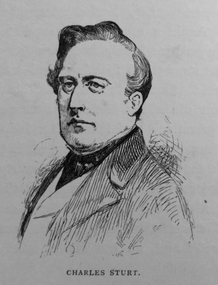
 Orbost & District Historical Society
£1 note, 1966
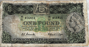
... On the reverse are Charles Sturt and Hamilton Hume. The signatories are: H. C. Coombs, Governor, Reserve Bank of Australia and Roland Wilson, Secretary to the Treasury. ...On the reverse are Charles Sturt and Hamilton Hume. The signatories are: H. C. Coombs, Governor, Reserve Bank of Australia and Roland Wilson, Secretary to the Treasury. ...The one pound note was the most prevalent banknote in circulation with the pound series, with the last series of 1953-66 having 1,066 million banknotes printed. The serial number HK 02 suggests it was printed in 1966.this item is an example of pre-decimal currency used in Australia.A green rectangular paper Australian £1 note. On the obverse is the Australian Coat of Arms and a picture of Queen Elizabeth II facing left. On the reverse are Charles Sturt and Hamilton Hume. The signatories are: H. C. Coombs, Governor, Reserve Bank of Australia and Roland Wilson, Secretary to the Treasury. The watermark is Captain Cook in left oval. Behind each signature is ’ONE POUND’. The serial number is HK 456416 02 currency-australia one-pound-note -
 Whitehorse Historical Society Inc.
Memorabilia - One pound Note, not known
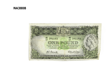
... The back of the note has 4 circles, one with 'One pound', one with picture of Charles Sturt 1795 - 1869, one with Hamilton Hume 1797 - 1873 and one with James Cook Endeavour. ...The back of the note has 4 circles, one with 'One pound', one with picture of Charles Sturt 1795 - 1869, one with Hamilton Hume 1797 - 1873 and one with James Cook Endeavour. ...The pound note was donated along with a one dollar note and several silver coins by Society member Joyce SutoPound was legal tender until 1966 when decimal currency replaced it with a gold coloured two dollar coinGreen minted stamp on white background of treated paper. The front of the note has a picture of Queen Elizabeth 2nd, the Australian Coat of Arms and 'One Pound' stamped on it. The back of the note has 4 circles, one with 'One pound', one with picture of Charles Sturt 1795 - 1869, one with Hamilton Hume 1797 - 1873 and one with James Cook Endeavour. Commonwealth of Australia is on the lower edge of the note.One Pound, Commonwealth of Australianumismatics, notes -
 Queenscliffe Maritime Museum
Map - Chart of Geelong Harbour, Geelong Harbour
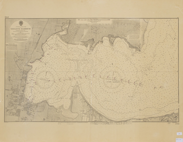
... When Hamilton Hume and William Hovell arrived at the bay in 1824 they met with the local Wautharong people who referred to the bay as "Jillong" and the surround land "Corayo", but by the time the area was surveyed in the late 1830s the Aboriginal names had been swapped. ...Queenscliffe Maritime Museum 2 Wharf St Queenscliff geelong-and-the-bellarine-peninsula When Hamilton Hume and William Hovell arrived at the bay in 1824 they met with the local Wautharong people who referred to the bay as "Jillong" and the surround land "Corayo", but by the time the area was surveyed in the late 1830s the Aboriginal names had been swapped. ...When Hamilton Hume and William Hovell arrived at the bay in 1824 they met with the local Wautharong people who referred to the bay as "Jillong" and the surround land "Corayo", but by the time the area was surveyed in the late 1830s the Aboriginal names had been swapped. The names "Corayo" and "Jillong" had since been Anglicised to "Corio" and "Geelong".Corio Bay is an important harbour and leisure location in the West and continues to attract development such as the new Tasmania Ferry Terminal.An Admiralty Chart of Geelong Harbour revised in 1954Geelong Harbour Map Ref: 2731geelong, corio, admiralty charts -
 Wodonga & District Historical Society Inc
Souvenir - Cup Hovell's Tree, Albury
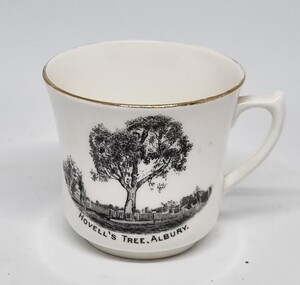
... The Hovell Tree, marked by William Hovell on November 17, 1824 was flanked by another tree marked by Hamilton Hume which was destroyed by fire in the 1840's. ...The Hovell Tree, marked by William Hovell on November 17, 1824 was flanked by another tree marked by Hamilton Hume which was destroyed by fire in the 1840's. ...This souvenir represents the Hovell Tree, a local historic landmark in Albury, NSW. This item is from a collection donated by descendants of John Francis Turner of Wodonga. The Hovell Tree commemorates the exploration and naming of the Hume River (now the Murray) by Hume and Hovell`s expedition of 1824. In 1824, Governor Brisbane asked Hume to join forces with an English sea captain, William Hovell, to go from Lake George to the Spencer Gulf in South Australia. The Hovell Tree, marked by William Hovell on November 17, 1824 was flanked by another tree marked by Hamilton Hume which was destroyed by fire in the 1840's. The river gum was marked by William Hovell when discovering river. Hume and Hovell travelled from the Yass area and after crossing the Murray River where Lake Hume now is, they crossed the Mitta Mitta River and proceeded to Corio Bay, Westernport.This item is representative of souvenirs produced to represent key buildings and historic landmarks in the Albury-Wodonga district.A white cup with gilt trim around the lip. It bears an image of the Hovell Tree in Albury, NSWBeneath image: "HOVELL'S TREE, ALBURY."albury souvenirs, hovell tree, hume and hovell, australian exploration -
 Bendigo Historical Society Inc.
Postcard - Elliot Postcard Collection: Australia, 1895 - 1914
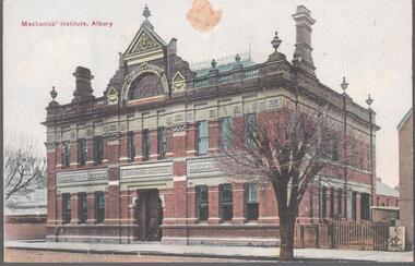
... Augustine, Yass 1405.074 Hume and Hovell Monument 1405.075 Flat Rock, Middle Harbour, Sydney 1405.076 the Dam, National Park, New South Wales 1405.077 Hamilton Hume's Monument, Albury Gardens 1405.078 The weir, Yass 1405.079 Lane Cove River, Sydney, N.S.W. 1405.080 Suspension Bridge, North Sydney...Augustine, Yass 1405.074 Hume and Hovell Monument 1405.075 Flat Rock, Middle Harbour, Sydney 1405.076 the Dam, National Park, New South Wales 1405.077 Hamilton Hume's Monument, Albury Gardens 1405.078 The weir, Yass 1405.079 Lane Cove River, Sydney, N.S.W. 1405.080 Suspension Bridge, North Sydney Postcard Elliot Postcard Collection: Australia ...Thought to have originated in Austria in 1869, postcards first gained popularity in Australia in the 1890s.They were used to send short messages to friends and family. This collection was generated by Mary Emma Elliot of Talgarno. Talgarno is a rural locality in Victoria, Australia, situated on the southern shoreline of Lake Hume, about 23 km east of Albury-Wodonga. The collection contains postcards from across the world. Mary Emma Sibley was born in Ironbark, Bendigo in 1859. She married James Elliot in 1893 and they settled at “Kelso”, Talgarno. They had two children – Mona and Sibley. Mary Emma Elliot died in Melbourne in 1944, aged 84 years. Australian postcards collected by Mrs. James Elliot between 1898 and 1915. 1405.061 Mechanic's Institute, Albury 1405.062 Kiama, N.S.W. 1405.063 Dean Street, Albury, N.S.W. 1405.064 Union Bank and Post Office, Temora 1405.065 Middle Harbour, Sydney 1405.066 Sydney University, Sydney 1405.067 Botanic Gardens, Sydney 1405.068 Bridge Street, Sydney 1405.069 Botanic Gardens, Sydney 1405.070 The Two Bridges, Yass 1405.071 Court house, Yass 1405.072 Church of St. Augustine, Yass 1405.073 The Grotto, Church of St. Augustine, Yass 1405.074 Hume and Hovell Monument 1405.075 Flat Rock, Middle Harbour, Sydney 1405.076 the Dam, National Park, New South Wales 1405.077 Hamilton Hume's Monument, Albury Gardens 1405.078 The weir, Yass 1405.079 Lane Cove River, Sydney, N.S.W. 1405.080 Suspension Bridge, North Sydneypostcards, collecting, collections, talgarno -
 Wodonga & District Historical Society Inc
Work on paper - Wodonga Lagoon (Huon's Lake), Des Martin, 1987
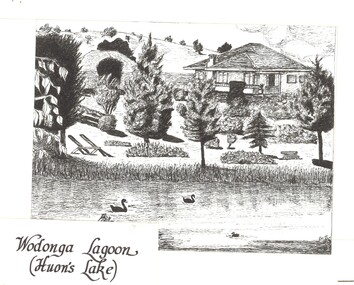
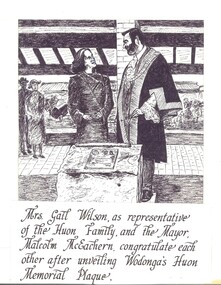
... Paul and Charles were to become the “founders’ of the Wodonga District. In 1824 Hamilton Hume and William Hovell discovered the Hume River, later renamed to the Murray River and the rich land surrounding it. ...Paul and Charles were to become the “founders’ of the Wodonga District. In 1824 Hamilton Hume and William Hovell discovered the Hume River, later renamed to the Murray River and the rich land surrounding it. ...Gabriel Louis Marie Huon de Kerilleau was born to a French aristocratic family in 1769. He escaped to England during the French Revolution and enlisted in the New South Wales Corps. He married in Parramatta to Louisa Emmanuel Le Sage. They had five children who took the name of Huon – Elizabeth, Paul, Jean Francois, Aime Augustus and Charles. Paul and Charles were to become the “founders’ of the Wodonga District. In 1824 Hamilton Hume and William Hovell discovered the Hume River, later renamed to the Murray River and the rich land surrounding it. By 1835, squatters began arriving at the Hume River. During the following year, Paul Huon arrived at the Hume (Murray) River, then "taking up" 40,000 acres on the south side of the river bank. To this property he gave the name WOODONGA RUN. Charles Huon, younger brother of Paul, was sent to manage the "Run" until Paul's son, William, became old enough to take over management. Charles Huon built a mud brick home on the eastern side of a rise south of the now Wodonga Creek. Thus was Charles the first permanent settler in the district. He was a great admirer of the English Lord Belvoir hence "Belvoir" was the name Charles Huon gave to the first permanent home on Woodonga Run. By the 1857, residents numbered fifty, and the Government had surveyed a township area, proclaiming it "Belvoir" in the new State of Victoria. However, the residents wanted their own choice of a name for the town. Huon’s first home overlooked a lagoon which was often referred to as Huon’s Lagoon. It has borne several names since then including Lake Huon and Belvoir Lagoon. After much redevelopment and many roles including the location of sporting fields and the Wodonga Golf Course, it is now known as Belvoir Park, a major parkland and recreation area in Wodonga.Donated by Des Martin & Rosemary BoyesPart of a set of original sketches by Des Martin for "A Record of the 150th Anniversary" Celebrations of the Rural City of Wodonga held on 30th October 1986.huon family, belvoir park wodonga, huon's lagoon -
 Wodonga & District Historical Society Inc
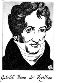
Work on paper - Huon Family Portraits, Des Martin, 1987
... Paul and Charles were to become the “founders’ of the Wodonga District. In 1824 Hamilton Hume and William Hovell discovered the Hume River, later renamed to the Murray River and the rich land surrounding it. ...Paul and Charles were to become the “founders’ of the Wodonga District. In 1824 Hamilton Hume and William Hovell discovered the Hume River, later renamed to the Murray River and the rich land surrounding it. ...Gabriel Louis Marie Huon de Kerilleau was born to a French aristocratic family in 1769. He escaped to England during the French Revolution and enlisted in the New South Wales Corps. He married in Parramatta to Louisa Emmanuel Le Sage. They had five children who took the name of Huon – Elizabeth, Paul, Jean Francois, Aime Augustus and Charles. Paul and Charles were to become the “founders’ of the Wodonga District. In 1824 Hamilton Hume and William Hovell discovered the Hume River, later renamed to the Murray River and the rich land surrounding it. By 1835, squatters began arriving at the Hume River. During the following year, Paul Huon arrived at the Hume (Murray) River, then "taking up" 40,000 acres on the south side of the river bank. To this property he gave the name WOODONGA RUN. Charles Huon, younger brother of Paul, was sent to manage the "Run" until Paul's son, William, became old enough to take over management. Charles Huon built a mud brick home on the eastern side of a rise south of the now Wodonga Creek. Thus was Charles the first permanent settler in the district. He was a great admirer of the English Lord Belvoir hence "Belvoir" was the name Charles Huon gave to the first permanent home on Woodonga Run. By the 1857, residents numbered fifty, and the Government had surveyed a township area, proclaiming it "Belvoir" in the new State of Victoria. However, the residents wanted their own choice of a name for the town. A battle lasting thirteen years followed over the name of the town until the residents won in 1874 when the Victorian Government dropped the name "Belvoir" and proclaimed the town's name as "Wodonga." A local government Shire formed two years later became the Shire of Wodonga. The Huon name features in the town today including Huon Hill, Huon Creek, Huon Street and the former township and railway siding at Huon. The name "Belvoir" is used today by organisations and locations in Wodonga including Belvoir Park formerly known as Huon’s Lagoon. On 3rd October 1986 the Wodonga community celebrated the 150th anniversary of the first settlement by Charles Huon of the district that was to become Wodonga. These drawings were completed by Desmond Martin as part of a booklet produced to record the event.Donated by Des Martin & Rosemary BoyesThree portraits of members of the Huon De Kerilleau Family, pioneers of Wodonga in Victoria. charles huon, huon de kerilleau, wodonga pioneers -
 Wodonga & District Historical Society Inc
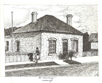
Work on paper - Stonleigh, Wodonga - Home of Paul Huon, Des Martin, 1987
... Paul and Charles were to become the “founders’ of the Wodonga District. In 1824 Hamilton Hume and William Hovell discovered the Hume River, later renamed to the Murray River and the rich land surrounding it. ...Paul and Charles were to become the “founders’ of the Wodonga District. In 1824 Hamilton Hume and William Hovell discovered the Hume River, later renamed to the Murray River and the rich land surrounding it. ...Gabriel Louis Marie Huon de Kerilleau was born to a French aristocratic family in 1769. He escaped to England during the French Revolution and enlisted in the New South Wales Corps. He married in Parramatta to Louisa Emmanuel Le Sage. They had five children who took the name of Huon – Elizabeth, Paul, Jean Francois, Aime Augustus and Charles. Paul and Charles were to become the “founders’ of the Wodonga District. In 1824 Hamilton Hume and William Hovell discovered the Hume River, later renamed to the Murray River and the rich land surrounding it. By 1835, squatters began arriving at the Hume River. During the following year, Paul Huon arrived at the Hume (Murray) River, then "taking up" 40,000 acres on the south side of the river bank. To this property he gave the name WOODONGA RUN. Charles Huon, younger brother of Paul, was sent to manage the "Run" until Paul's son, William, became old enough to take over management. Charles Huon built a mud brick home on the eastern side of a rise south of the now Wodonga Creek. Thus was Charles the first permanent settler in the district. He was a great admirer of the English Lord Belvoir hence "Belvoir" was the name Charles Huon gave to the first permanent home on Woodonga Run. By the 1857, residents numbered fifty, and the Government had surveyed a township area, proclaiming it "Belvoir" in the new State of Victoria. However, the residents wanted their own choice of a name for the town. A battle lasting thirteen years followed over the name of the town until the residents won in 1874 when the Victorian Government dropped the name "Belvoir" and proclaimed the town's name as "Wodonga." A local government Shire formed two years later became the Shire of Wodonga. The Huon name features in the town today including Huon Hill, Huon Creek, Huon Street and the former township and railway siding at Huon. The name "Belvoir" is used today by organisations and locations in Wodonga including Belvoir Park formerly known as Huon’s Lagoon. On 3rd October 1986 the Wodonga community celebrated the 150th anniversary of the first settlement by Charles Huon of the district that was to become Wodonga. These drawings were completed by Desmond Martin as part of a booklet produced to record the event. Stonleigh in Wodonga was once owned by Paul Huon.Donated by Des Martin & Rosemary BoyesPart of a set of original sketches by Des Martin for "A Record of the 150th Anniversary" Celebrations of the Rural City of Wodonga held on 30th October 1986.150th anniversary celebrations, huon family, early wodonga, stonleigh wodonga -
 Wodonga & District Historical Society Inc
Work on paper - 150th Anniversary Celebrations of the Rural City of Wodonga, Des Martin, 1987
... Paul and Charles were to become the “founders’ of the Wodonga District. In 1824 Hamilton Hume and William Hovell discovered the Hume River, later renamed to the Murray River and the rich land surrounding it. ...Paul and Charles were to become the “founders’ of the Wodonga District. In 1824 Hamilton Hume and William Hovell discovered the Hume River, later renamed to the Murray River and the rich land surrounding it. ...Gabriel Louis Marie Huon de Kerilleau was born to a French aristocratic family in 1769. He escaped to England during the French Revolution and enlisted in the New South Wales Corps. He married in Parramatta to Louisa Emmanuel Le Sage. They had five children who took the name of Huon – Elizabeth, Paul, Jean Francois, Aime Augustus and Charles. Paul and Charles were to become the “founders’ of the Wodonga District. In 1824 Hamilton Hume and William Hovell discovered the Hume River, later renamed to the Murray River and the rich land surrounding it. By 1835, squatters began arriving at the Hume River. During the following year, Paul Huon arrived at the Hume (Murray) River, then "taking up" 40,000 acres on the south side of the river bank. To this property he gave the name WOODONGA RUN. Charles Huon, younger brother of Paul, was sent to manage the "Run" until Paul's son, William, became old enough to take over management. Charles Huon built a mud brick home on the eastern side of a rise south of the now Wodonga Creek. Thus was Charles the first permanent settler in the district. He was a great admirer of the English Lord Belvoir hence "Belvoir" was the name Charles Huon gave to the first permanent home on Woodonga Run. By the 1857, residents numbered fifty, and the Government had surveyed a township area, proclaiming it "Belvoir" in the new State of Victoria. However, the residents wanted their own choice of a name for the town. A battle lasting thirteen years followed over the name of the town until the residents won in 1874 when the Victorian Government dropped the name "Belvoir" and proclaimed the town's name as "Wodonga." A local government Shire formed two years later became the Shire of Wodonga. The Huon name features in the town today including Huon Hill, Huon Creek, Huon Street and the former township and railway siding at Huon. The name "Belvoir" is used today by organisations and locations in Wodonga including Belvoir Park formerly known as Huon’s Lagoon. On 3rd October 1986 the Wodonga community celebrated the 150th anniversary of the first settlement by Charles Huon of the district that was to become Wodonga. These drawings were completed by Desmond Martin as part of a booklet produced to record the event. Donated by Des Martin & Rosemary BoyesPart of a set of original sketches by Des Martin for "A Record of the 150th Anniversary" Celebrations of the Rural City of Wodonga held on 30th October 1986.150th anniversary celebrations, huon family -
Marysville & District Historical Society
Article (item) - Book Extract, Aboriginal History, Unknown
... hume and hovell...molesworth...broadford...william hamilton...The extract also covers current (1991) status of Aboriginal affairs and European settlement of the area. kulin nation woiworung taungurong bunurong watherong jajowrong wurrundjeri-willam waring-ilam-balluk goulburn valley acheron valley upper goulburn district eildon-thornton eildon homestead o'rourke thornton assistant protector thomas yarra valley kilmore mount william jt gellibrand william buckley major mitchell port phillip murray river yorta yorta yowung-illam-balluk waring-illam-balluk ngurai-illam-wurrung kurnai nation protectorate system victoria george robinson chief protector willam thomas james dredge edward parker charles sievewright central board for the protection of aborigines presbyterian mission anglican mission moravian mission wonga munnarin beaning murrin murrin parugean baruppin koo-gurrin acheron river little river acheron run peter snodgrass stephen jones barak dividing range black spur watts river badger creek healesville coranderrk victorian christmas bush aboriginal and torres strait islander heritage protection act 1984 archaelological and aboriginal relics preservation act 1972 camp jungai rubicon warrawa college victorian archaeological survey hume and hovell molesworth broadford william hamilton alexandra mansfield avenel tallarook worrough john cotton trawool valley seymour pyalong gold mining central victoria strath creek reedy creek yea jamieson marysville jordan goldfields comet mine wandong melbourne-albury railway rabbit plague narbethong lord kitchener puckapunyal military camp 1944 decentralisation policy eildon weir hume freeway bypass timber industry australian paper manufacturers mill An extract from a book regarding a brief history of the Kulin nation of the North Central district of Victoria. ...An extract from a book regarding a brief history of the Kulin nation of the North Central district of Victoria.An extract from a book regarding a brief history of the Kulin nation of the North Central district of Victoria. This history covered is both prior to European history and post-European history. The extract also covers current (1991) status of Aboriginal affairs and European settlement of the area.kulin nation, woiworung, taungurong, bunurong, watherong, jajowrong, wurrundjeri-willam, waring-ilam-balluk, goulburn valley, acheron valley, upper goulburn district, eildon-thornton, eildon homestead, o'rourke, thornton, assistant protector thomas, yarra valley, kilmore, mount william, jt gellibrand, william buckley, major mitchell, port phillip, murray river, yorta yorta, yowung-illam-balluk, waring-illam-balluk, ngurai-illam-wurrung, kurnai nation, protectorate system, victoria, george robinson, chief protector, willam thomas, james dredge, edward parker, charles sievewright, central board for the protection of aborigines, presbyterian mission, anglican mission, moravian mission, wonga, munnarin, beaning, murrin murrin, parugean, baruppin, koo-gurrin, acheron river, little river, acheron run, peter snodgrass, stephen jones, barak, dividing range, black spur, watts river, badger creek, healesville, coranderrk, victorian christmas bush, aboriginal and torres strait islander heritage protection act 1984, archaelological and aboriginal relics preservation act 1972, camp jungai, rubicon, warrawa college, victorian archaeological survey, hume and hovell, molesworth, broadford, william hamilton, alexandra, mansfield, avenel, tallarook, worrough, john cotton, trawool valley, seymour, pyalong, gold mining, central victoria, strath creek, reedy creek, yea, jamieson, marysville, jordan goldfields, comet mine, wandong, melbourne-albury railway, rabbit plague, narbethong, lord kitchener, puckapunyal military camp, 1944 decentralisation policy, eildon weir, hume freeway bypass, timber industry, australian paper manufacturers mill -
 Hume City Civic Collection
Photograph, 1906
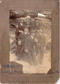
... Hume City Civic Collection 44 Macedon Street Sunbury melbourne This is a photo of a group of six men taken at Sorrento Back Beach February 1906. eadie bill ford gus hamilton tom millet frank wilson jim o'brien terence sorrento m'nicol a. e. photographers clothing and dress george evans collection Printed on mounting: A. ...This is a photo of a group of six men taken at Sorrento Back Beach February 1906.B/W photo of a group of six men in suits and hats.Printed on mounting: A. E. M'NICOL Written in biro across photo at bottom: TOP. Bill Eadie, Gus Ford, Tom Hamilton Bottom row Frank Millet, Jim Wilson, Terence O'Brieneadie, bill, ford, gus, hamilton, tom, millet, frank, wilson, jim, o'brien, terence, sorrento, m'nicol, a. e., photographers, clothing and dress, george evans collection -
 Wodonga & District Historical Society Inc
Book - Table Top 1824 - 1984, Merrick L Webb
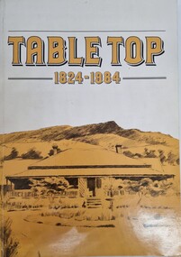
... Known by the Aborigines as Mullyan-argina, or breeding place of eagles, the flat topped hill attracted the attention of Hume and Hovell's expedition in November 1824 and Hamilton Hume named Battery Mount. Later on, when the Mitchell family acquired the run they named it Table Top. ...This publication was compiled for the Centenary celebrations of the Table Top school in 1984. Known by the Aborigines as Mullyan-argina, or breeding place of eagles, the flat topped hill attracted the attention of Hume and Hovell's expedition in November 1824 and Hamilton Hume named Battery Mount. Later on, when the Mitchell family acquired the run they named it Table Top. The book contains detailed information about the district and pioneer families who contributed to its development.A paperback publication of 80 pages including photographs and maps compiled by the Table Top History Committee.This publication was compiled for the Centenary celebrations of the Table Top school in 1984. Known by the Aborigines as Mullyan-argina, or breeding place of eagles, the flat topped hill attracted the attention of Hume and Hovell's expedition in November 1824 and Hamilton Hume named Battery Mount. Later on, when the Mitchell family acquired the run they named it Table Top. The book contains detailed information about the district and pioneer families who contributed to its development.table top nsw, hume & hovell, the mitchell family, table top pioneers -
 Wodonga & District Historical Society Inc
Book - The Old Hume Highway - History begins with a Road, 2014
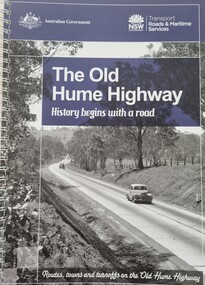
... Old Hume Highway hume highway Travel Guide Hume Highway \ The Hume Highway was officially named in 1928, when both the New South Wales and Victorian governments agreed to give the unified inland route between Sydney and Melbourne the name, honouring explorer Hamilton Hume who, with William Hovell, first found the overland path in 1824. ...The Hume Highway was officially named in 1928, when both the New South Wales and Victorian governments agreed to give the unified inland route between Sydney and Melbourne the name, honouring explorer Hamilton Hume who, with William Hovell, first found the overland path in 1824. Much of the original highway followed their overland route wherever the landscape allowed. The road connected many small communities and rural properties, although in many parts was narrow and unsurfaced. Over the following years alterations and some deviations occurred with changing transport needs and heavier traffic loads. One of these deviations was completed in 1933 at Table Top north of Albury between Ettamogah and Mullengandra due to the construction of the Hume Weir which flooded the existing highway. Gradually sections of the road were converted to a dual carriageway. In 1961 the first modern freeway-standard, four-lane section was completed in Victoria at Craigieburn. The Hume Highway was also rerouted in Albury to avoid the town centre. Many major bypasses and duplications in New South Wales were completed throughout the 1980s and 1990s. In 1994 the last section of the Hume Highway in Victoria was duplicated with the completion of the Wangaratta bypass. The Albury-Wodonga bypass was opened in 2007 and in 2013 the final section, the Holbrook Bypass in NSW, was opened to traffic on August 7, completing the full Sydney-Melbourne dual carriageway link. In the course of this gigantic engineering achievement, many small, historic towns throughout Victoria and New South Wales were bypassed and often forgotten by passing commuters in a rush to reach their destination. This publication includes maps and information about the sites and landmarks in these towns. It encourages travellers to venture of the modern highway and rediscover the Old Hume Highway and the stories it holds about out past.A spiral bound volume of 122 pages including maps, photographs and illustrations prepared as a travel guide to the Old Hume Highway. It includes a Foreword by Peter FitzSimons.The Hume Highway was officially named in 1928, when both the New South Wales and Victorian governments agreed to give the unified inland route between Sydney and Melbourne the name, honouring explorer Hamilton Hume who, with William Hovell, first found the overland path in 1824. Much of the original highway followed their overland route wherever the landscape allowed. The road connected many small communities and rural properties, although in many parts was narrow and unsurfaced. Over the following years alterations and some deviations occurred with changing transport needs and heavier traffic loads. One of these deviations was completed in 1933 at Table Top north of Albury between Ettamogah and Mullengandra due to the construction of the Hume Weir which flooded the existing highway. Gradually sections of the road were converted to a dual carriageway. In 1961 the first modern freeway-standard, four-lane section was completed in Victoria at Craigieburn. The Hume Highway was also rerouted in Albury to avoid the town centre. Many major bypasses and duplications in New South Wales were completed throughout the 1980s and 1990s. In 1994 the last section of the Hume Highway in Victoria was duplicated with the completion of the Wangaratta bypass. The Albury-Wodonga bypass was opened in 2007 and in 2013 the final section, the Holbrook Bypass in NSW, was opened to traffic on August 7, completing the full Sydney-Melbourne dual carriageway link. In the course of this gigantic engineering achievement, many small, historic towns throughout Victoria and New South Wales were bypassed and often forgotten by passing commuters in a rush to reach their destination. This publication includes maps and information about the sites and landmarks in these towns. It encourages travellers to venture of the modern highway and rediscover the Old Hume Highway and the stories it holds about out past.old hume highway, hume highway, travel guide hume highway, \ -
Koorie Heritage Trust
Booklet, Boys, Robert Douglass, Australian History : Summary of historical events from 1768
... Koorie Heritage Trust Levels 1 & 3, Yarra Building Federation Square, Melbourne melbourne Australia-History-Summary 1768-1834 Australia-Discovery and exploration-summary Port Phillip-Settlement p.17-35 Contents:James Cook; Arthur Phillip; John Pascoe Fawkner; The Sydney Cove; George Bass; Tobias Furneaux; John Hunter; Matthew Flinders and George Bass; John Batman; James Grant; John Murray; Discovery of Port Phillip Bay; Proposed Settlement at Port Phillip; Matthew Flinders; Nicolas Baudin and Emmanuel Hamelin; Charles Robbins; Charles Grimes; The Settlement at Sullivan Bay, Sorrento; General Orders; Garrison Orders; Some Events at Sullivan Bay; Western Port; Edward Henty; Sealing; The Geordy; John Oxley; Hamilton Hume and William Hilton Hovell; The Settlement at Western Port; Port Fairy and Portland Bay; Charles Sturt; The Lively; Portland Bay and the Hentys; 36 p. ; footnotes; 24 cm. ...Contents: James Cook; Arthur Phillip; John Pascoe Fawkner; The Sydney Cove; George Bass; Tobias Furneaux; John Hunter; Matthew Flinders and George Bass; John Batman; James Grant; John Murray; Discovery of Port Phillip Bay; Proposed Settlement at Port Phillip; Matthew Flinders; Nicolas Baudin and Emmanuel Hamelin; Charles Robbins; Charles Grimes; The Settlement at Sullivan Bay, Sorrento; General Orders; Garrison Orders; Some Events at Sullivan Bay; Western Port; Edward Henty; Sealing; The Geordy; John Oxley; Hamilton Hume and William Hilton Hovell; The Settlement at Western Port; Port Fairy and Portland Bay; Charles Sturt; The Lively; Portland Bay and the Hentys;36 p. ; footnotes; 24 cm.Contents: James Cook; Arthur Phillip; John Pascoe Fawkner; The Sydney Cove; George Bass; Tobias Furneaux; John Hunter; Matthew Flinders and George Bass; John Batman; James Grant; John Murray; Discovery of Port Phillip Bay; Proposed Settlement at Port Phillip; Matthew Flinders; Nicolas Baudin and Emmanuel Hamelin; Charles Robbins; Charles Grimes; The Settlement at Sullivan Bay, Sorrento; General Orders; Garrison Orders; Some Events at Sullivan Bay; Western Port; Edward Henty; Sealing; The Geordy; John Oxley; Hamilton Hume and William Hilton Hovell; The Settlement at Western Port; Port Fairy and Portland Bay; Charles Sturt; The Lively; Portland Bay and the Hentys; australia-history-summary 1768-1834, australia-discovery and exploration-summary, port phillip-settlement p.17-35 -
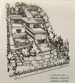 Kew Historical Society Inc
Drawing - Property Illustration, Margaret Picken, 7 Hume Street, Kew, 1998
... Hume Street was designed in 1955 by the modernist architect Douglas Alexandra (1922-2000). Between 1951 and 1996, Alexandra completed a number of significant projects including a regional art gallery and library complex at Hamilton, Victoria (1958-59). ...Hume Street was designed in 1955 by the modernist architect Douglas Alexandra (1922-2000). Between 1951 and 1996, Alexandra completed a number of significant projects including a regional art gallery and library complex at Hamilton, Victoria (1958-59). ...After training as a Cartographic Draftsman within the mining industry, I worked as a property illustrator for real estate firms in the eastern suburbs of Melbourne for 23 years from 1983. I initially photographed houses with a Polaroid camera and made a 'thumbnail' sketch while there. The photos were used to scale off a sketch in pencil and then that sketch was overlaid with drafting film and the 'pen and ink' completed. The pens I used were the Rotring ‘Rapidigraph’ drafting pens. The ink was also made by Rotring (German).The film was ‘Rapidraw’, polyester drafting film, double matte. It takes a very fine line and doesn’t bleed. As well as house sketches, there were often floor plans and site plans ordered. Aerial sketches were ordered when the property needed an overall view. (Margaret Picken, 2020)The house at 7 Hume Street was designed in 1955 by the modernist architect Douglas Alexandra (1922-2000). Between 1951 and 1996, Alexandra completed a number of significant projects including a regional art gallery and library complex at Hamilton, Victoria (1958-59). The residence in Hume Street is included in the RAIA Victorian Chapter's 20th Century Buildings Register. The house, and another residence in Molesworth Street (1961), is one of his notable residential projects. The aerial property illustration of the house by Margaret Picken was commissioned by the real estate agent Woodards in 1998. Gift of Margaret Picken, 2020Pen and ink property illustration on drafting film of 7 Hume Street, Kew by Margaret Picken.7 HUME ST., KEW / MARGARET PICKEN ~98 / WOODARDS ~ HAWTHORN artist -- margaret picken 1950-, 7 hume street - kew (vic)., d.d. alexandra - architect, property illustrations -- buildings -- kew (vic.)