Showing 228 items matching "hand-drawn map"
-
 Wodonga & District Historical Society Inc
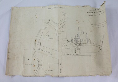
Map - Hamilton-Smith Collection Hand Drawn Map of Wodonga c1938
... Hamilton-Smith Collection Hand Drawn Map of Wodonga c1938...Hamilton-Smith Collection Hand Drawn Map of Wodonga c1938...A map hand drawn in black pen on thick beige paper. ...Hamilton-Smith Collection Hand Drawn Map of Wodonga c1938 Map Hamilton-Smith Collection Hand Drawn Map of Wodonga c1938 ...The Hamilton-Smith collection was donated by the children of Grace Mary Hamilton-Smith nee Ellwood (1911-2004) and John Hamilton-Smith (1909-1984) who settled in Wodonga in the 1940s. The Ellwood family had lived in north-east Victoria since the late 1800s. Grace’s mother, Rosina Ellwood nee Smale, was the first teacher at Baranduda in 1888, and a foundation member of the C.W.A. Rosina and her husband Mark retired to Wodonga in 1934. Grace and John married at St. David’s Church, Albury in 1941. John was a grazier, and actively involved in Agricultural Societies. The collection contains significant items which reflect the local history of Wodonga, including handmade needlework, books, photographs, a wedding dress, maps, and material relating to the world wars. This item is unique, handmade and has a known owner. It forms part of a significant and representative historical collection which reflects the local history of Wodonga. It contributes to our understanding of social and family life in early twentieth century Wodonga, as well as providing interpretative capacity for themes including local history and social history.A map hand drawn in black pen on thick beige paper. map, subdivison, development, wodonga, local history, hamilton-smith, hamilton-smith collection -
 Marysville & District Historical Society
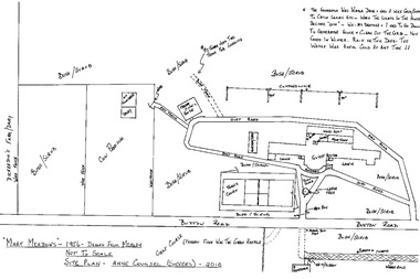
Map (item) - Hand drawn map, Anne Counsel, 2010
... Hand drawn map......hand-drawn map...A hand-drawn map of Mary-Meadows guest house drawn by Anne Counsel (Sievers) from her memories of the guest house. ...A hand-drawn map of Mary-Meadows guest house drawn by Anne Counsel (Sievers) from her memories of the guest house. ...Marysville & District Historical Society 39 Darwin Street Marysville yarra-valley-and-the-dandenong-ranges A hand-drawn map of Mary-Meadows guest house drawn by Anne Counsel (Sievers) from her memories of the guest house. ...A hand-drawn map of Mary-Meadows guest house drawn by Anne Counsel (Sievers) from her memories of the guest house. The map was of Mary-Meadows in 1956 and was drawn in 2010. Mary-Meadows and was part of the Mary Chain of guest houses built by Eric Dowdle in Marysville. A hand-drawn map of Mary-Meadows guest house drawn by Anne Counsel (Sievers) from her memories of the guest house.marysville, victoria, australia, mary chain guesthouses, eric dowdle, rita dowdle, marylands, mary lyn, mary lodge, kerami, mary meadows, mary brook, barron of beef, mary port, guest house, photograph, sherbrooke, mount martha, the golf house, el kanah, mary chain golf links, map, anne counsel (sievers), hand-drawn map, alec sievers, rene sievers, robert sievers, anne sievers -
 Beechworth Honey Archive
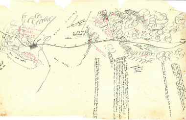
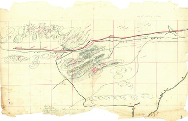
Hand-Drawn Map Centred on Ararat by Frank Lebbell Frost December 1916
... Hand-Drawn Map Centred on Ararat by Frank Lebbell Frost December 1916...Hand Drawn...Hand-Drawn...Map...Front Side: Hand-drawn map centred on Ararat, central Victoria. ... Drawn Hand-Drawn Map Ararat Frost Beekeeper Beechworth Honey Front Side: Hand-drawn map centred on Ararat, central Victoria. ...This is one of the maps drawn by Frank L. Frost while he was beekeeping in North-East Victoria. This particular map may be reference in the "Wooden" Diary on page 11. Front Side: Hand-drawn map centred on Ararat, central Victoria. Details road and railway and vegetation with comments on flowering. Back Side: Comments in grey lead [ca 1923]hand drawn, hand-drawn, map, ararat, frost, beekeeper, beechworth honey -
 Beechworth Honey Archive
Hand-Drawn Map Centred on Armstrong by Frank Lebbell Frost Dec 1916
... Hand-Drawn Map Centred on Armstrong by Frank Lebbell Frost Dec 1916...Hand Drawn...Hand-Drawn...Map...Hand-drawn map centred on Armstrong, a town 6 miles from Ararat. ... Drawn Hand-Drawn Map Armstrong Ararat Frost Beekeeper Beechworth Honey Hand-drawn map centred on Armstrong, a town 6 miles from Ararat. ...This is one of the maps drawn by Frank L. Frost while he was beekeeping in North-East Victoria. This particular map may be reference in the "Wooden" Diary on page 11.Hand-drawn map centred on Armstrong, a town 6 miles from Ararat. Details vegetation along Great Western Highway. Drawn with black pen and grey lead on paper. Features are marked in red.hand drawn, hand-drawn, map, armstrong, ararat, frost, beekeeper, beechworth honey -
![Hand-Drawn Map Centred on Myrtleford by Frank Lebbell Frost [ca 1915-1918]](/media/collectors/51d110e42162ef12e06aa06b/items/51fb0bb72162ef156c79aeee/item-media/52a11c442162ef1f0c9c052b/item-fit-380x285.jpg?cb=6) Beechworth Honey Archive
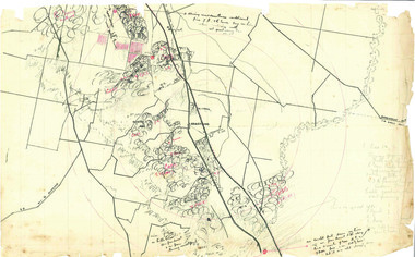
Beechworth Honey ArchiveHand-Drawn Map Centred on Myrtleford by Frank Lebbell Frost [ca 1915-1918]
... Hand-Drawn Map Centred on Myrtleford by Frank Lebbell Frost [ca 1915-1918]...Hand Drawn...Hand-Drawn...Map...Hand-drawn map centred on Myrtleford, Palmerston, Gapstead Road, the Ovens River and the Myrtleford-Wangaratta Road. ... Drawn Hand-Drawn Map Myrtleford Palmerston Gapstead Ovens Beekeeping Frost Beechworth Honey Hand-drawn map centred on Myrtleford, Palmerston, Gapstead Road, the Ovens River and the Myrtleford-Wangaratta Road. ...This is one of the maps drawn by Frank L. Frost while he was beekeeping in North-East Victoria. This particular map may be reference in the "Wooden" Diary on page 8.Hand-drawn map centred on Myrtleford, Palmerston, Gapstead Road, the Ovens River and the Myrtleford-Wangaratta Road. Shows locations of flowering eucalypts. Scale is 1 mile to 1 inch. Drawn with black pen and grey lead on paper. Names of towns are marked in red pen. hand drawn, hand-drawn, map, myrtleford, palmerston, gapstead, ovens, beekeeping, frost, beechworth honey -
 Beechworth Honey Archive
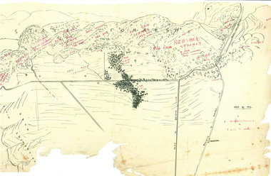
Hand-Drawn Map Centred on Worouly by Frank Lebbell Frost December 1916
... Hand-Drawn Map Centred on Worouly by Frank Lebbell Frost December 1916...Hand Drawn...Hand-Drawn...Map...Hand-drawn map centred on Whorouly and showing other towns, including Oxley, Byrne, Edi and Whitfield. ... Drawn Hand-Drawn Map Oxley Byrne Whitfield Edi Frost Beekeeping Beechworth Honey Hand-drawn map centred on Whorouly and showing other towns, including Oxley, Byrne, Edi and Whitfield. ...This is one of the maps drawn by Frank L. Frost while he was beekeeping in North-East Victoria. This particular map may be reference in the "Wooden" Diary on page 10.Hand-drawn map centred on Whorouly and showing other towns, including Oxley, Byrne, Edi and Whitfield. Details the local flowering eucalypts. Scale is each red square equals three miles. Drawn with black pen and grey lead on paper. Grid and other features are marked in red.hand drawn, hand-drawn, map, oxley, byrne, whitfield, edi, frost, beekeeping, beechworth honey -
 Beechworth Honey Archive
Hand-Drawn Map Centred on Buckland Gap Road by Frank Lebbell Frost July 1916
... Hand-Drawn Map Centred on Buckland Gap Road by Frank Lebbell Frost July 1916...Hand Drawn...Hand-Drawn...Map...Hand-drawn map centred on Buckland Gap road (near Murmungee). ... Drawn Hand-Drawn Map Buckland Gap Frost Beekeeper Beechworth Honey Hand-drawn map centred on Buckland Gap road (near Murmungee). ...This is one of the maps drawn by Frank L. Frost while he was beekeeping in North-East Victoria. This particular map may be reference in the "Wooden" Diary on page 8.Hand-drawn map centred on Buckland Gap road (near Murmungee). Details the quantity and quality of flowering timber in the nearby State Forest. Scale is 1/2 mile to 1 inch. Map was drawn on the 16th July, 1916. Drawn with black pen and grey lead on paper. Features are marked in red.hand drawn, hand-drawn, map, buckland gap, frost, beekeeper, beechworth honey -
![Hand-Drawn Map Centred on Chiltern by Frank Lebbell Frost [ca 1915-1918]](/media/collectors/51d110e42162ef12e06aa06b/items/51fb08452162ef156c79a623/item-media/52a11e6d2162ef1f0c9c0af4/item-fit-380x285.jpg?cb=6) Beechworth Honey Archive
Beechworth Honey ArchiveHand-Drawn Map Centred on Chiltern by Frank Lebbell Frost [ca 1915-1918]
... Hand-Drawn Map Centred on Chiltern by Frank Lebbell Frost [ca 1915-1918]...Hand Drawn...Hand-Drawn...map...Front Side: Hand-drawn map centred on Chiltern showing the Melbourne road [Hume Freeway] and the Beechworth-Rutherglen road with detailed locations of flora in the region. ... Drawn Hand-Drawn map Chiltern 1915 Beekeeper Frost Beechworth Honey Front Side: Hand-drawn map centred on Chiltern showing the Melbourne road [Hume Freeway] and the Beechworth-Rutherglen road with detailed locations of flora in the region. ...This is one of the maps drawn by Frank L. Frost while he was beekeeping in North-East Victoria. This particular map may be reference in the "Wooden" Diary on pages 12, 13 and 17.Front Side: Hand-drawn map centred on Chiltern showing the Melbourne road [Hume Freeway] and the Beechworth-Rutherglen road with detailed locations of flora in the region. Flora includes; Iron Bark, Stringy Bark, Red Box and Yellow Box. Details regarding quantity of flowers and quality of trees is included. Back Side: Some names and addresses are recorded in pencil. Drawn with black pen and grey lead on paper. A grid and other symbols are marked in red ink.hand drawn, hand-drawn, map, chiltern, 1915, beekeeper, frost, beechworth honey -
 Warrnambool RSL Sub Branch
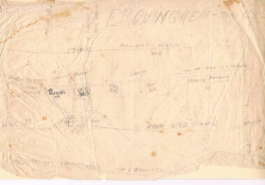
Bob Snape's HAND-DRAWN MAP of ERQUINGHAM-SUR -LYS, FRANCE, centring on 6th Field Ambulance base
... Bob Snape's HAND-DRAWN MAP of ERQUINGHAM-SUR -LYS, FRANCE, centring on 6th Field Ambulance base....Warrnambool RSL Sub Branch Cnr Merri & Liebig Streets Warrnambool great-ocean-road Snape Collection Bob Snape's HAND-DRAWN MAP of ERQUINGHAM-SUR -LYS, FRANCE, centring on 6th Field Ambulance base. ...snape collection -
 Bendigo Historical Society Inc.
Document - CONSTABLE RYAN COLLECTION: HAND DRAWN MAP OF AREA OF CONSTABLE RYAN DISAPPEARANCE
... CONSTABLE RYAN COLLECTION: HAND DRAWN MAP OF AREA OF CONSTABLE RYAN DISAPPEARANCE...An hand drawn map of the area of constable Ryan disappearance. ...History House 11 Mackenzie Street Bendigo goldfields DOCUMENT An hand drawn map of the area of constable Ryan disappearance. ...An hand drawn map of the area of constable Ryan disappearance. The map is not to scale.document -
 Peterborough History Group
Map - Map of Peterborough House 1921, 1921
... This hand drawn map of the buildings and out buildings was done for insurance purposes. ...A4 photocopy of a hand drawn map of the buildings and out buildings comprising Peterborough House. ...Hand drawn map...For example, 'sleep outs' and external bathrooms. Hand drawn map A4 photocopy of a hand drawn map of the buildings and out buildings comprising Peterborough House. ...This hand drawn map of the buildings and out buildings was done for insurance purposes. It indicates which buildings are covered and which are uninsured. Significant as it shows a plan of the hotel as it was in 1921. Each building is labelled by its purpose, which provides an interesting insight into holidays of the time. For example, 'sleep outs' and external bathrooms. A4 photocopy of a hand drawn map of the buildings and out buildings comprising Peterborough House. Hand drawn map -
 Ringwood and District Historical Society
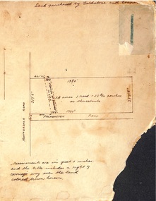
Map, Hand-drawn map of block of land on Heatherdale Road and Palmerston Road, Ringwood, Vic. (Undated)
... Hand-drawn map of block of land on Heatherdale Road and Palmerston Road, Ringwood, Vic. ...One of three unrelated maps on cardboard backing. Hand-drawn map of block of land on Heatherdale Road and Palmerston Road, Ringwood, Vic. ...One of three unrelated maps on cardboard backing.Handwritten notations - Land purchased by Goldstone and Cooper; 14 acres, 1 rood and 28-8/10 perches or thereabouts; Creation of easement to S.E.C. -
 Ringwood and District Historical Society
Drawing - Hand-drawn map, Part of Crown Allotment 22, Ringwood East, Victoria (Undated)
... Hand-drawn map ...Part of Crown Allotment 22, Ringwood East, Victoria (Undated). Drawing Hand-drawn map ...Pencil drawing on light cardboard backing. Colour-shaded residential allotments on Rosedale Crescent, Patterson Street and Federal Road, Ringwood East.(Railway line to Healesville marked on the map indicates creation date precedes closure of line beyond Lilydale in 1980) -
 Croydon Conservation Society Inc.
Map, Hand drawn location map of Cheong Wildflower Sanctuary, Croydon 1991
... Hand drawn location map of Cheong Wildflower Sanctuary, Croydon 1991...Croydon melbourne Handwritten inscription on top of map: Croydon 1991 A4 sized handwritten map Hand drawn location map of Cheong Wildflower Sanctuary, Croydon 1991 Map ...A4 sized handwritten mapHandwritten inscription on top of map: Croydon 1991 -
 Eltham District Historical Society Inc
Map, Geoff Braithwaite, Braithwaite ma0p of Eltham circa 1920
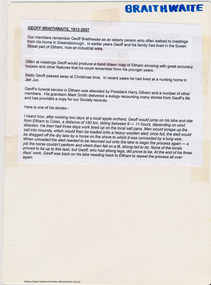
... A3 photocopy of hand drawn map of Eltham created by Geoff Braithwaite (1914-2008) of his memory of the township about 1920. ...Folder of information on Geoff Braithwaite Includes A3 photocopy of hand drawn map of Eltham with coloured shading of Eltham in 1920s and 1930s...Eltham District Historical Society Inc 728 Main Rd Eltham melbourne A3 photocopy of hand drawn map of Eltham created by Geoff Braithwaite (1914-2008) of his memory of the township about 1920. ...A3 photocopy of hand drawn map of Eltham created by Geoff Braithwaite (1914-2008) of his memory of the township about 1920. It includes names of streets and property owners. Folder of information on Geoff Braithwaite Includes A3 photocopy of hand drawn map of Eltham with coloured shading of Eltham in 1920s and 1930sharry gilham collection, eltham, 1920, geoff braithwaite, map, smart family cottage, eltham cemetery, flora caroline braithwaite (nee gamble), geoffrey braithwaite -
Whitehorse Historical Society Inc.
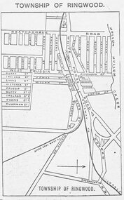
Map, This is Vermont, 1895-1920?
... Hand-drawn map of Vermont from Springvale Road to Heatherdale Road, showing the names of owners of houses, main roads and streets, shops and schools....'Now you have seen it, tell your friends' - hand-drawn map of Vermont from Springvale Road to Heatherdale Road, showing the names of owners of houses, main roads and streets, shops and schools....Whitehorse Historical Society Inc. 2-10 Deep Creek Road Mitcham melbourne Hand-drawn map of Vermont from Springvale Road to Heatherdale Road, showing the names of owners of houses, main roads and streets, shops and schools. ...'Now you have seen it, tell your friends''Now you have seen it, tell your friends' - hand-drawn map of Vermont from Springvale Road to Heatherdale Road, showing the names of owners of houses, main roads and streets, shops and schools.'Now you have seen it, tell your friends' vermont south, vermont, roads and streets -
 Greensborough Historical Society
Article - Cemeteries, David Weatherill, Donnybrook (Kalkallo) Cemetery, 10/09/1857o
... Hand drawn map of cemetery....Weatherill donnybrook (kalkallo) cemetery Hand drawn map of cemetery. 4 pages, text and maps. ...A short history of the Donnybrook (Kalkallo) Cemetery by David W. Weatherill4 pages, text and maps.Hand drawn map of cemetery.donnybrook (kalkallo) cemetery -
 Port Melbourne Historical & Preservation Society
Document, Hotels in Port Melbourne
... I did know that there was a murder there."Inside is hand drawn map of Port Melbourne with the hotels marked in position as well as a Key down the left hand side. ...A large ruled sheet of paper with a letter on the outside & inside a hand drawn map of Port Melbourne with the location of hotels marked. ...I did know that there was a murder there."Inside is hand drawn map of Port Melbourne with the hotels marked in position as well as a Key down the left hand side. ...The letter on the outside of the sheet is from Jim (?) to Les (Turner). It gives some of his childhood recollections of Port Melbourne Hotels These include the Shamrock which he understood that it was "... a weatherboard Building - very Badly Conducted and when it was burned down it was not rebuilt... I did know that there was a murder there."Inside is hand drawn map of Port Melbourne with the hotels marked in position as well as a Key down the left hand side. The accompanying typed sheet lists the 50 original hotels on the left hand side and the 20 remaining on the right.A large ruled sheet of paper with a letter on the outside & inside a hand drawn map of Port Melbourne with the location of hotels marked. A typed sheet lists the hotels.Hotels of Port Melbourne. Originally there were 50. today there are 20.business and traders - hotels, shamrock hotel, leslie stanley turner -
 City of Moorabbin Historical Society (Operating the Box Cottage Museum)
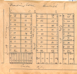
Plan - Grandview Estate
... Hand drawn map of subdivision ...Example of the progress of the Municipality of Moorabbin Centre Road Evelyn Street (now Wilson Street) Lily Street Bentleigh realestate auction Grandview Estate, Bentleigh Hand drawn map of subdivision Plan Grandview Estate ...The train line from the city to Frankston was electrified in 1922 which intensified the sale in the municipality of Moorabbin, particularly land which was in the vicinity of the railway stations.The train line from the city to Frankston was electrified in 1922 which intensified the sale in the municipality of Moorabbin, particularly land which was in the vicinity of the railway stations. The Grandview Estate was auctioned on Saturday 10 November 1922.Example of the progress of the Municipality of MoorabbinHand drawn map of subdivision Grandview Estate, Bentleighcentre road, evelyn street (now wilson street), lily street, bentleigh, realestate, auction -
 Ringwood and District Historical Society
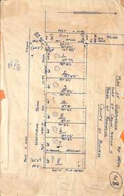
Map, Subdivision Plan - 8 residential allotments south of City Road on Wantirna Road, Ringwood, Victoria - (Undated - circa 1950s)
... Hand-drawn map on cardboard backing....(North arrow incorrectly points east.) Hand-drawn map on cardboard backing. Subdivision Plan - 8 residential allotments south of City Road on Wantirna Road, Ringwood, Victoria - (Undated - circa 1950s) Map ...Hand-drawn map on cardboard backing.Part of Crown Portion 11, Parish of Ringwood, County of Bourke. Some allotments include real estate sales notations. (North arrow incorrectly points east.) -
 Ringwood and District Historical Society
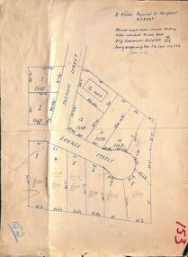
Map, Subdivision Plan - House and 13 residential allotments fronting Fremont Street Ringwood, Vic., and George Street (later Tudor Court), Heathmont, Vic. - Undated, circa 1922
... Hand-drawn map on cardboard backing....Willis, Fremont Street Ringwood - WU6073. Hand-drawn map on cardboard backing. Subdivision Plan - House and 13 residential allotments fronting Fremont Street Ringwood, Vic., and George Street (later Tudor Court), Heathmont, Vic. - Undated, circa 1922. ...Hand-drawn map on cardboard backing.Formed road with concrete kerbing. Water available to each block. No. of subdivision A139880 73/419. Part of Certificate of Title Vol 5323 Fol 539. Real estate sales notations on some allotments include price. Heading also includes address and phone number of H. Willis, Fremont Street Ringwood - WU6073. -
 Ringwood and District Historical Society
Document, Directory of Ringwood Township, from Sands and McDougall Directory - 1905
... Black and white hand drawn map...Black and white hand drawn map Directory of Ringwood Township, from Sands and McDougall Directory - 1905. ...Black and white hand drawn mapStreet shown as Heatherdale Road should read New Street. -
Stawell Historical Society Inc
Map, Farm Plan Bryn Avon Callawadda
... Beige Hand Drawn map of farm and paddocks...Stawell Historical Society Inc 46 Longfield St Stawell grampians Farming Agriculture Farm Plan "BRYN AVON" Callawadda Scale 1 in = 10 chains Beige Hand Drawn map of farm and paddocks Farm Plan Bryn Avon Callawadda Map ...Beige Hand Drawn map of farm and paddocksFarm Plan "BRYN AVON" Callawadda Scale 1 in = 10 chainsfarming, agriculture -
Whitehorse Historical Society Inc.
Document, Mitcham Township 1914 - 1917, n.d
... Hand drawn map of Mitcham township c1914....Whitehorse Historical Society Inc. 2-10 Deep Creek Road Mitcham melbourne Boxshall Hilda Mitcham Hand drawn map of Mitcham township c1914. Hand drawn map of Mitcham township c1914. ...Hand drawn map of Mitcham township c1914.Hand drawn map of Mitcham township c1914.Hand drawn map of Mitcham township c1914.boxshall, hilda, mitcham -
 Ringwood and District Historical Society
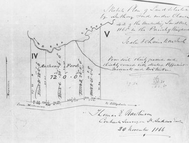
Document, Ford's land at Heatherdale Road, north side of Whitehorse Road, 1866
... Black and white copy of hand drawn map...Black and white copy of hand drawn map Ford's land at Heatherdale Road, north side of Whitehorse Road, 1866. ...Black and white copy of hand drawn mapNote written on document reads: "Sketch plan of land selected by Anthony Ford under Clause 42 of the amending Land Act 1865 in the Parish of Ringwood. Signed by Thomas E Rawlinson, Contract Surveyor, 20 November, 1866. -
 Peterborough History Group
Document - Establishment of Peterborough
... Copies of maps, pages of books and hand drawn map...Peterborough History Group Peterborough great-ocean-road Details progress of establishment of the district and the town Information about the town being Gazetted; Massacre Bay information baradh clan peterborough peterborough history buckley creek run massacre bay Copies of maps, pages of books and hand drawn map Establishment of Peterborough Document Establishment of Peterborough ...Details progress of establishment of the district and the town Information about the town being Gazetted; Massacre Bay informationCopies of maps, pages of books and hand drawn mapbaradh clan, peterborough, peterborough history, buckley creek run, massacre bay -
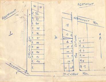 Ringwood and District Historical Society
Map - Subdivision Plans, Residential allotments in Orchid Street and The Outlook, between Heathmont Road and Dickason Road, Heathmont, Victoria - (Undated - circa 1940)
... Two adjoing hand-drawn maps on light cardboard backing....Ringwood and District Historical Society 125A Warrandyte Road Ringwood North melbourne Two adjoing hand-drawn maps on light cardboard backing. Residential allotments in Orchid Street and The Outlook, between Heathmont Road and Dickason Road, Heathmont, Victoria - (Undated - circa 1940) Map Subdivision Plans ...Two adjoing hand-drawn maps on light cardboard backing. -
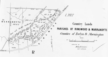 Ringwood and District Historical Society
Map, Early map of Parishes of Ringwood and Warrandyte in Counties of Evelyn and Mornington - c.1868, 1868
... Black and white hand drawn map of Ringwood and Warrandyte areas....(From Parish Map collection) Black and white hand drawn map of Ringwood and Warrandyte areas. ...Black and white hand drawn map of Ringwood and Warrandyte areas.Map surveyed by M. Callanan, Assistant Surveyor. Written on rear of backing sheet: "c1868. Vol. 5, Fol.13/1224." (From Parish Map collection) -
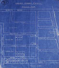 Ringwood and District Historical Society
Map, Plan of Subdivision - Cherry Garden Estate, Ringwood East, Victoria. Circa 1950
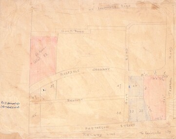
... Blue hand-drawn map of residential subdivision surrounding Tintern School....Ringwood and District Historical Society 125A Warrandyte Road Ringwood North melbourne Map includes Dublin Road, Shasta Avenue, Education Department land in Alexandra Road, and numbered allotments in Knaith Road, Northwood Street, Langley Street and Bondi Street, Ringwood East, Victoria. Blue hand-drawn map of residential subdivision surrounding Tintern School. ...Blue hand-drawn map of residential subdivision surrounding Tintern School.Map includes Dublin Road, Shasta Avenue, Education Department land in Alexandra Road, and numbered allotments in Knaith Road, Northwood Street, Langley Street and Bondi Street, Ringwood East, Victoria. -
Whitehorse Historical Society Inc.
Document, List of schools in the city of Nunawading, 1969
... List of schools in the City of Nunawading and hand drawn map showing locations....Whitehorse Historical Society Inc. 2-10 Deep Creek Road Mitcham melbourne City of Nunawading Schools List of schools in the City of Nunawading and hand drawn map showing locations. List of schools in the city of Nunawading Document Document ...List of schools in the City of Nunawading and hand drawn map showing locations.city of nunawading, schools